3 minute read
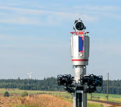
RIEGL VMR


Robotic Rail Laser Scanning System
• automated stop & go solution for high precision 3D measurements
• fast and easy setup, transportable in a standard car
• >6 h continuous operation with only one battery
• track gauge adjustable from 1,000 mm to 1,435 mm
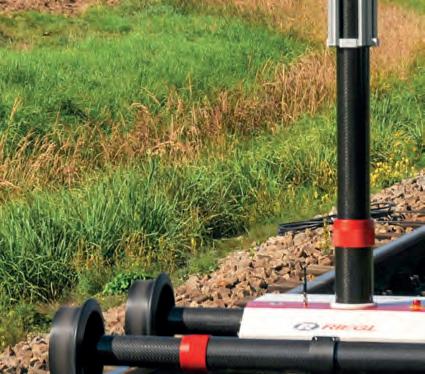
• RTK GNSS possible via internal or external receiver


• external control points can be integrated into the workflow
• internal data storage

Singaporean alliance organizes geospatial-oriented AI challenge
In collaboration with AI Singapore, the Singapore Land Authority (SLA) has launched an innovative challenge centered on visual localization, aimed at addressing how AI can accurately extract camera pose data from 2D images. This is an essential concept in computer vision that refers to the exact position and orientation of a camera in 3D space relative to reference coordinate systems. AI Singapore is a partnership between economic agencies and academia. The search for new solutions that combine artificial intelligence (AI) and geospatial technology fits in with Singapore’s role as a leader in technology and innovation. AI technologies have revolutionized 3D mapping, benefiting smart city applications and improving quality of life. However, acquiring 3D data is expensive, hindering frequent or large-scale updates. To overcome this, researchers and technologists are investigating the use of AI to extract 3D information from readily available 2D images. Through advancements in visual odometry, the organizers of the AI challenge aim to expand 3D learning, making it affordable and sustainable for diverse real-world applications. Participants of the challenge are tasked with developing AI models capable of accurately extracting camera pose data from a provided set of 2D monocular images. The results must be submitted in a prescribed plain text format. This exciting competition offers a platform for talented individuals and teams to showcase their expertise and innovation in the realm of AI.

Trimble introduces new 3D laser scanning system
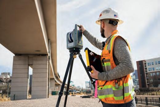
Trimble has recently announced the Trimble X9 3D laser scanning system, a versatile reality capture solution for surveying, construction and engineering professionals. The X9 is built on Trimble’s proven laser scanning technologies and is engineered to enhance performance in various environments. It incorporates innovations such as Trimble X-Drive technology for automatic instrument calibration, survey-grade self-levelling, and a laser pointer for georeferencing. The new Trimble X9 expands on the industry-proven Trimble X7, offering longer range, higher accuracy, shorter scan times and exceptional sensitivity. These improvements lead to better scan results and increased productivity. Advanced processing and a high-performance laser enhance the sensitivity of all scans, positioning the X9 at the forefront of capturing difficult dark or reflective surfaces. Additionally, a new centre unit design enhances signal transmission, resulting in better scan quality. With its more efficient reality capture capabilities, the X9 widens the range of potential applications for customers in surveying, building construction, oil and gas, rail, forensics, monitoring, tunnelling, mining and other fields. The newly developed laser scanning system is designed to offer substantial time savings while providing extremely accurate and reliable data. This capability enables confident decision-making, both in the field and in the office, by allowing in-field registration within Trimble Perspective and Trimble FieldLink. This innovative feature minimizes the requirement for target deployment, streamlining the workflow.
Field buys AI drone-tech firm PrecisionHawk
Field has announced its acquisition of PrecisionHawk, a US-based artificial intelligence (AI) and drone technology company for infrastructure management. With a premium client list of Fortune 500 companies,
PrecisionHawk supports Field’s international growth strategy, particularly in terms of expansion in the USA. “We’re on a mission to build and maintain a better tomorrow with smarter and more sustainable insights from geospatial data. We’re thrilled to merge our products and technology to offer world-class infrastructure management solutions to customers across the US, Europe and beyond,” says Cato Vevatne, CEO of Field. The two companies’ proprietary software and inspection technologies using artificial intelligence and machine learning offer an exciting new inspection and analytics solution to the US infrastructure and energy sectors. Field is a renowned provider of digital reality services in Europe, specializing in utilizing a combination of software, sensors and autonomous technologies to improve efficiency and reliability in the infrastructure, construction, environment and public sectors. Its innovative approach puts data to work in practical ways, streamlining operations and enhancing performance. Meanwhile, PrecisionHawk is a leading industry player with a comprehensive offering that spans from high-quality data collection to advanced AI algorithms which provide actionable intelligence. As a result, the company is well-equipped to deliver end-to-end solutions that support a variety of needs and use cases.
Leica Geosystems unveils autonomous mobile mapping solution

Leica Geosystems, part of Hexagon, has introduced the Leica Pegasus TRK100 as the latest addition to its portfolio of mobile mapping solutions. Specifically designed for GIS professionals, the new mobile mapping system is a powerful, user-friendly geospatial solution built for large-scale infrastructure measurement and digital twin creation. The Pegasus TRK portfolio is known for its simplicity, lightweight yet robust design, and integration with intelligent, autonomous systems. The Pegasus TRK100 is lighter and smaller, weighing just 14kg, which makes it easy for just one person to mount on any vehicle. The new mobile mapping system features the same modular hardware approach that allows users to add more cameras to expand the range of use cases. The Pegasus TRK100 is designed to excel in GIS mapping and asset management applications, providing essential location intelligence for georeferenced visual data. Tailored for GIS professionals, it empowers them to transform their business operations. The system puts control into their hands for quick and autonomous data collection and asset information capture.
How is the role of surveyors evolving in the age of AI?


