20 minute read
Report: FIG Congress 2022
LOOKING BACK ON THE FIG CONGRESS 2022
Shining a Light on the Surveying Profession
The 27th edition of the FIG Congress took place in the Polish capital of Warsaw from 11-15 September 2022. As always, this gathering of the land surveying community featured a large number of highly relevant keynotes, seminars and sessions. But after more than two years of COVID-19 restrictions, it also turned out to be an event full of enthusiastic reunions between acquaintances as well as a place for forming new friendships. This article starts by giving an impression of the congress in a nutshell, followed by contributions from two young participants. Between them, they paint a picture of the event from the refreshing perspective of the new generation of surveyors.
The focus of the 27th edition of the FIG Congress was on the changing face of the surveying profession. The job of a land surveyor has changed radically over the years. Nowadays, geospatial data is applied across a wide range of disciplines in a much broader context. It is being recognized as a vital part of the solution for the well-being and betterment of society as a whole. This is being further accelerated by the rapidly advancing technological developments of the past decade, such as increased computational power and the miniaturization of sensors. The geospatial experts of today are continuously exploring new ways of tapping into the potential of these and other technological advancements.
GETTING TOGETHER TO SHARE EXPERTISE
The backbone of the FIG Congress was formed by the keynote sessions and a broad
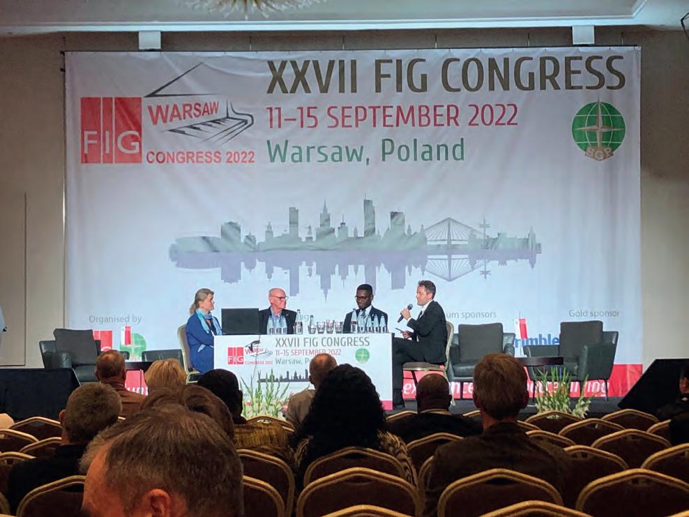
The top-class panel discussion with Paula Dijkstra, Stig Enemark and Kwabena Obeng Asiama on land governance in support of the 2030 Global Agenda was one of the highlights of the FIG Congress 2022.
range of technical sessions. The abundance of presentations covered almost every conceivable topic under the ‘geospatial data umbrella’. The content of the keynotes varied from land governance in support of the 2030 Global Agenda – zooming in on the concept of responsible land governance and the importance of including all land, people and land rights at a countrywide scale – to mapping plastic pollution in the Earth’s oceans by employing multispectral imagery in conjunction with artificial intelligence and deep learning algorithms. With support from the local organizers from the Association of Polish Surveyors (SGP), this year’s FIG Congress was an important hub for intensive learning and a valuable platform for the FIG community to exchange knowledge and experiences during the workshops, seminars and sessions. One of the keynotes, given by outgoing FIG president (and incoming DVW president) Rudolf Staiger, took the audience on a journey through the history of surveying. Staiger visibly entertained the audience with his dynamic insights into how the 3rd and 4th industrial revolutions have had huge impact on the surveying profession. He explained that the profession is now based on connectivity and computing power, and the ‘Surveyor 4.0’ is “using his or her equipment like a big office software package – just push the button.” Staiger ended his keynote by emphasizing the need for events such as the FIG Congress and other gatherings where the geospatial community can get together to exchange knowledge. And after the inspiring days in Warsaw, most participants will probably agree that meeting up in person is indeed a very enjoyable and effective way of keeping pace with the changing face of the surveying profession!
The upcoming issues of GIM International will feature various articles written by land surveying professionals and geospatial experts who spoke during the FIG Congress in Warsaw. In the meantime, for an overview of all the keynote sessions, see the FIG website: https://www.fig.net/news/news_2022/10_ congress_report.asp.
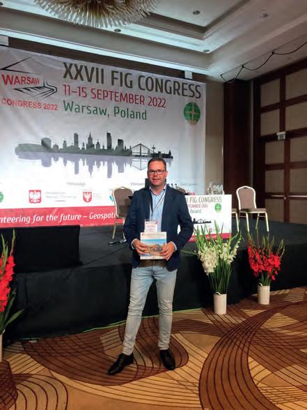
GIM International was official media partner of the FIG Congress 2022. Pictured here: Head of Content Wim van Wegen.
A Sense of Community
BY ANGELINA AGEENKO
After a COVID-19 break, the FIG Congress finally opened its doors again to participants in 2022. It was attended by professionals from all over the world across numerous surveying disciplines including geoinformatics, geodesy and land management, to name but a few. Warsaw, the beautiful and charming capital of Poland, with its castles, palaces, universities and parks, served as the backdrop to this year’s congress. As a first-timer at a FIG conference, I had a perfect and long-awaited opportunity to attend the event in person, get exposed to new ideas, build professional relationships and become a part of the international surveying community.
The congress was preceded by a number of events, of which I attended the FIG Young Surveyors Network. The programme, tightly packed with activities, was not only dedicated to the professional development of young surveyors through technical lectures. A special place in the Young Surveyors Network was given to building a strong sense of the international surveying community though social activities such as field games, geo-puzzles, competitions related to the use of the newest surveying equipment and a museum visit that introduced us to the hospitable Polish culture. This sense of community is indispensable and precious in the world, where cooperation and volunteering for a professional organization such as FIG are an urgent need. This was so precisely captured and reflected by the overall theme of the congress: ‘Volunteering for the Future – Geospatial excellence for better living’. It was a great inspiration to listen to peers from North America and Africa who
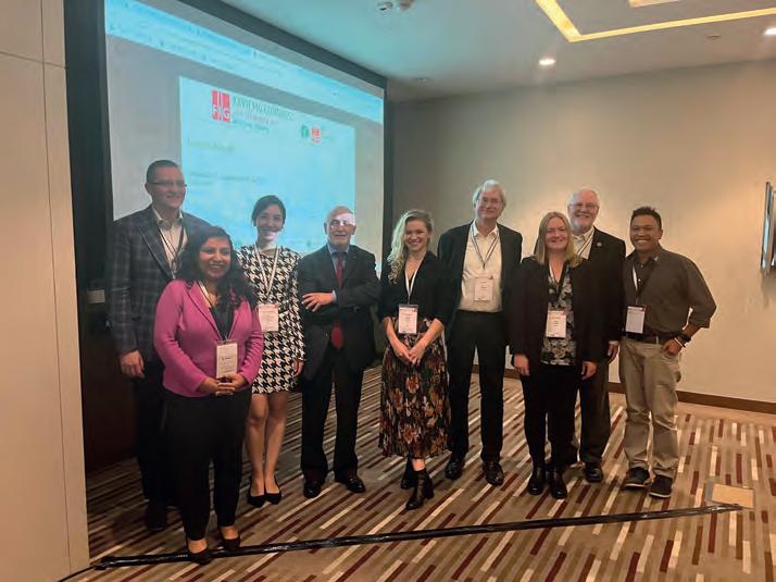
keep networks active in their countries, or who find ways of contributing to their society by leveraging the power of geospatial information to combat COVID-19.
After two days in the company of fellow young surveyors, I was overwhelmed by the main part of the congress and the abundance of the technical sessions, workshops and events it offered. Even though the scale and the size of the congress was quite different from what we are used to at home in Denmark, I always
It is difficult to tell if it was a lack of in-person connection over the previous years or a true feeling of progress, but the buzz at this year’s FIG Congress and Young Surveyors Conference was palpable. It was the best one I’ve been to so far (best out of three). Obviously, it is hard to compare with the first one I attended because that is where I got a taste for the nerdy joy that comes from FIG Working Weeks. But this one in Warsaw, Poland, brought out all FIG’s best for us young surveyors who were lucky enough to be there. Meeting representatives of the ‘big players’ (such as World Bank, Esri, Trimble and United Nations organizations) not only adds context and a friendly face to the projects, models and technology available in our industry, but felt welcomed and guided by both the FIG team and the local organizing team during my stay in Warsaw.
The sessions brought into sharp focus the solutions and the challenges that our multifaceted profession currently experiences and will face in the future. They might vary in different countries, but one thing seemed certain – surveyors will remain the link between the technological advancements and the Sustainable Development Goals. I was
it also provides exposure to role models for a young surveyor to see what opportunities can exist for them beyond their day-to-day work. They can visualize a future in our industry beyond that millimetre, bolt, boundary or calculation. It allows a young surveyor to picture themselves in our industry and see how they can carve out their place within a bigger picture.
Inspiration for a young surveyor to continue furthering their knowledge stems from the technical sessions. It is always tricky to choose which sessions to attend, with simultaneous sessions being a necessity for the programme organizers to fit it all into one week. I was able to learn about the wide body of research lucky enough to get the chance to present my work on landslide susceptibility mapping using artificial intelligence at the congress and feel happy that I could make a small contribution to this wonderful event.
Angelina Ageenko presented her paper on ‘Landslide Susceptibility Mapping in Denmark – a Machine Learning Approach’ on Wednesday 14 September 2022 in the session TS07C: Geospatial Analytics Use Cases.
The FIG Congress Seen from a Young Surveyor’s Perspective
BY CLAIRE BUXTON
around land administration using fit-forpurpose techniques, clever tools designed to empower young surveyors while mapping deforestation trends, and participate in meetings and workshops to discuss the future direction of FIG. It is humbling as a person who has gained privilege from living within countries with strong land tenure systems and stable governments to be invigorated by other young surveyors and experts who dedicate their lives to the improvement of land systems in their own contexts and communities. Attending an international conference can be daunting, especially if you haven’t been to one before. A young surveyor learns quickly that FIG is as supportive as a well-braced control network. When you arrive, you will learn that
the way you dress does not define you, for example. In fact, if your luggage is held up at customs, you can likely find a friendly person to lend you an outfit while you’re waiting for it to arrive. I loved seeing people wearing their favourites, from customary clothing through to a Wonder Woman t-shirt. When presenting, the speaker receives questions that will challenge them but will not accuse. There is a genuine interest from attendees to learn from the perspective of a young surveyor. Finally, meeting other young surveyors and seasoned surveyors with a similar energy for their careers is a huge bonus. Connections like these are worth continuing to build on and lean on for support. Your network grows fast within FIG. Young surveyors can see first-hand which geospatial tools are out there. Robotics, automation and other front-end technology that some parts of the industry are perhaps not even ready for in their own country were displayed at the FIG congress. This can give young surveyors an understanding of what exists before it may even reach their context. Better yet, they could bring it to their own country and offer a new service to generate income for their organizations and improve delivery for their clients. Of course, we didn’t just get spoiled with technical content and demonstrations of the latest technologies; we also got to experience the local flavours and customs of Warsaw. With the charity dance (which is always well attended and supported), pure Polish vodka tastings and traditional dancing and food on offer during the week, we were treated to a teaser of Polish culture to cherish.
Despite all of this, I recognize we have still got improvements to make. I say ‘we’ because, as a volunteer-run organization, FIG rests on the shoulders of all its volunteers. It is up to us as members of both FIG and the wider surveying industry to continue striving for improvement. Whether by supporting the Stand for her Land campaign and the Volunteer Community Surveyor Program, creating a place for diverse people to come together and feel at home as themselves, being an ally to promote diversity, equity and inclusion, or bringing together the academic/private practice gap, we each have a role to play. A big word of thanks to the organizers for bringing this event together. From where I am sitting, the stress and hectic hours were all worth it. Knowing that our industry is broad and connected provides motivation for young surveyors to stay on this career path, but also to seek out collaboration and growth opportunities for their individual selves and for the industry. It is easy to gain inspiration from meeting with an international community of surveyors. The trick is now for the commission chairs and FIG leadership to convert that inspiration into sustained energy for next year and the years to come. As the incoming FIG president, Dr Diane Dumashie, said to me during the welcoming ceremony, “many hands make light work”. Let us roll up our sleeves, support each other, learn from each other and keep shining a light on our wonderful profession.
Claire Buxton is working as a consultant at Underhill Geomatics, Canada, and is an active member of the FIG Young Surveyors Network, most recently as the leader of the Volunteer Community Surveyor Program (VCSP). Before moving to Canada, she volunteered for the Survey and Spatial New Zealand Young Professionals and Pacific Advisory Group from 2015 onwards. She spends much of her spare time as a volunteer supporting young surveyors internationally in growing the VCSP.
52 DEGREES NORTH
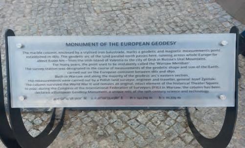
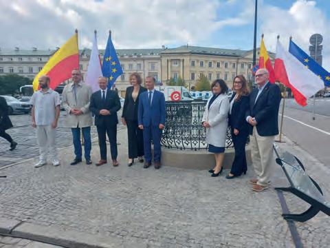
As the symbolic finale of the FIG Congress in Poland and a material memento of this ‘festival of world geodesy’ in the heart of Europe, an unusual geodesic monument was unveiled on Theatre Square in the centre of Warsaw: a survey pillar dating from 1872. The pillar was originally erected as a geodetic and magnetic surveying station for the 52nd parallel north geodetic arc survey project in the second half of the 19th century. It formed part of a triangulation chain spanning the whole of Europe, from Ireland to the Ural Mountains. Created with the cooperation of Struve, Baeyer and many other famous surveyors and astronomers such as Airy, Helmert and Žylinski, the chain lasted for 40 years. The pillar survived the destruction of Warsaw during the Second World War and, on 14 September 2022 – exactly 150 years after it was erected – this unusual relic from the history of geodesy was unveiled in memory of the FIG Congress in Warsaw as the European Geodesy Monument. This is an important step towards the 52nd parallel north geodetic arc being added to the UNESCO World Heritage List as the first truly international Earth surveying project on a continental scale. The coordinates of this monument to the scientific collaboration of European surveyors are (BLH, GRS80-ETRF89): 52°14’38.30338” N, 21°00’33.03398” E.
Glory to the science of surveying: geodesy!
Mariusz Meus (also known as ‘Mr Meridian’), head of the ‘Honorary Krakow Meridian’ geodesic educational initiative.
The unveiling of the geodesic monument on Theatre Square in the centre of Warsaw: a survey pillar dating from 1872.
IBKS pushes the boundaries of scan-to-BIM with NavVis and PointFuse in a towering project
IBKS is a digital solutions and management consulting firm offering built-environment services in the healthcare space. The firm recently tested its innovative NavVis and PointFuse workflow in a huge, complex healthcare facility – and succeeded beyond all expectations.
KEY TAKEAWAYS · IBKS built a fast and accurate scan-to-BIM workflow around two powerful tools with low barriers to entry, NavVis VLX and
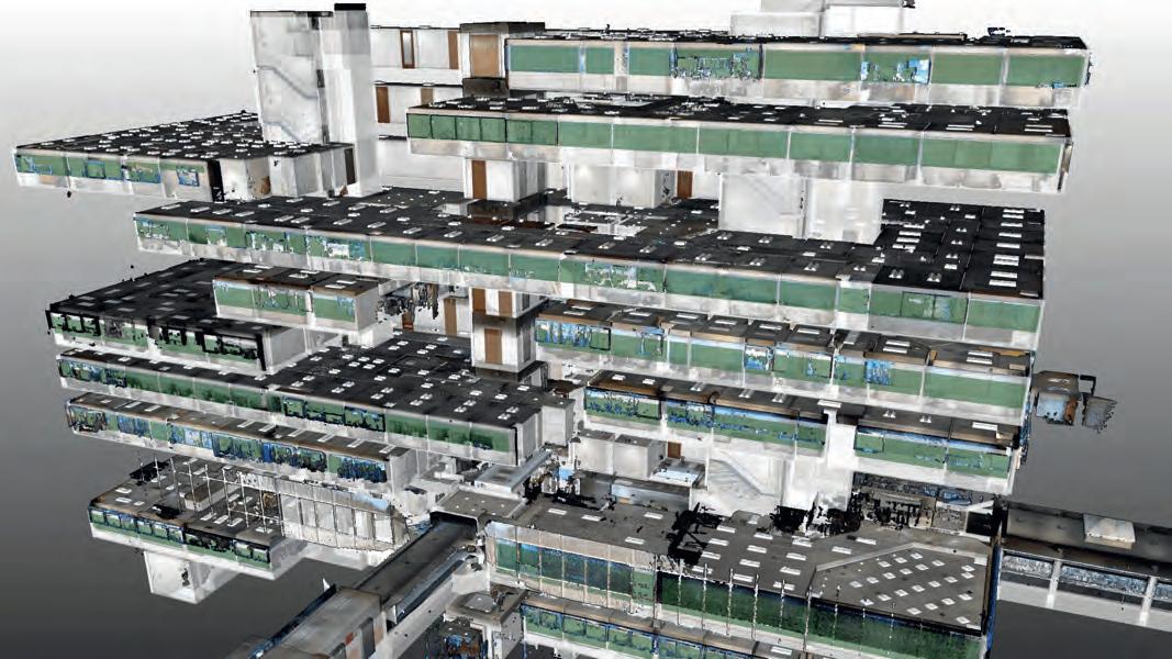
PointFuse Pro · The team started delivering complex scan-to-BIM projects in the medical space almost immediately · Recently, IBKS took on a two-tower, 450,000-square-foot healthcare project in Los Angeles · With NavVis VLX, each 11-storey tower took only 10 days to scan · With PointFuse Pro, each floor was prepared for Autodesk Revit in only 12 hours TALL ORDER In 2022, IBKS landed a big scan-to-BIM project for a large medical complex on the border of Beverly Hills and West Hollywood in Los Angeles. This site sprawls over 375,000 square feet — covering multiple medical suites and two 11-storey towers. Including exterior elements, the sum balloons to over 450,000 square feet.
It was the biggest scan-to-BIM project undertaken by IBKS to date. It was also a huge test for the firm’s innovative scanto-BIM workflow, which they had recently built around the NavVis VLX mobile scanner and PointFuse Pro software. INNOVATE OUT OF THE GATE According to Mo Haidar, founder of IBKS, the firm had only recently added reality capture to its services portfolio. IBKS had some in-house scan-to-BIM experience, but much of it was five years old — or even older — so the main players were essentially starting afresh.
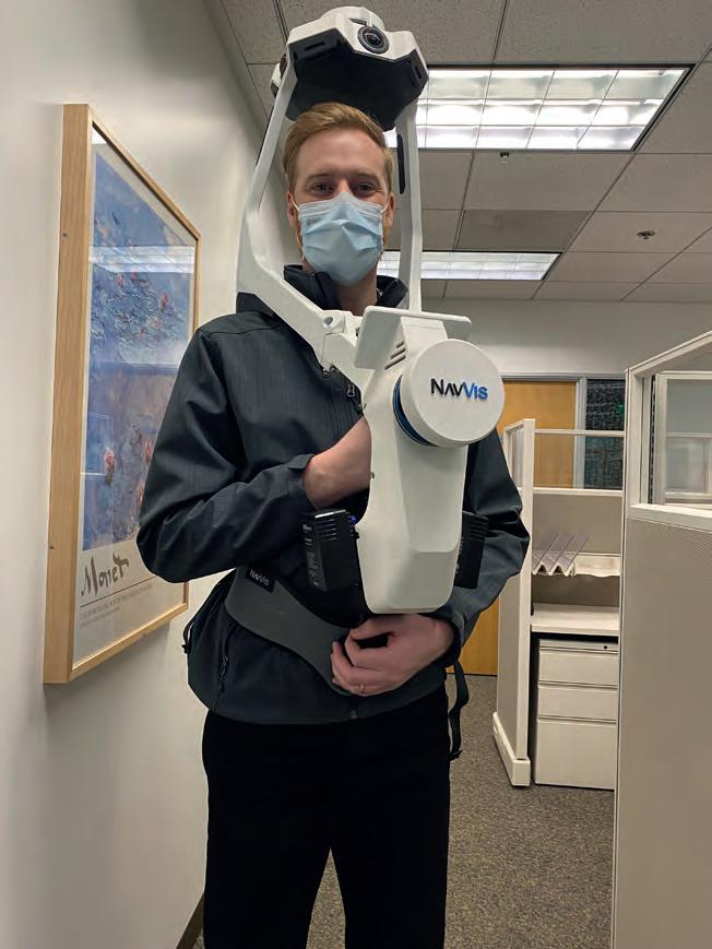
This proved to be a strength rather than a weakness. IBKS was able to build an innovative workflow with no preconceptions about the “best” tools to use. As Haidar explains, IBKS “did research for every device that’s out there, and quickly realized that our use case would require a mobile mapping
approach. And we pretty much knew that it was going to be the NavVis Reality Capture Solution: NavVis VLX and NavVis IVION. It was obvious because they offered no barrier to entry and no intimidation whatsoever.”
Spivey Lipsey, digital twin solutions lead with IBKS, adds that the mobile-mapping solution wasn’t just beginner friendly, it also met the firm’s stringent technical requirements for work in healthcare, “We were looking for a fair amount of accuracy, but we also have a lot of square footage to cover. The scanner hit that sweet spot of accuracy and speed.”
To complement their NavVis solution, IBKS looked for a downstream scan-to-BIM tool that offered a similar combination of a low barrier to entry, speed, and data quality. They found it in PointFuse Pro. This software would automatically classify surfaces, generate meshes of their point clouds to reduce file size, and produce LOD 200 models rapidly. And it would be very easy to use.
Lipsey says the most important factor, however, was that IBKS could be sure the tools would hang together as a complete workflow. “Someone that begins their adventure into this space — as they’re trying to procure software and hardware for their solution — they quickly understand that there is a very convoluted world of software versions and compatibility issues. And many of the software solutions are counterintuitive.”
“A big selling point for me,” he adds, “is that NavVis and PointFuse already had a collaboration. That lent a degree of confidence that these tools would work together.” With the right tools in place, IBKS then worked with the technical teams at NavVis and PointFuse to hone the workflow over a handful of large scan-to-BIM projects. The firm used these jobs to develop best practices for maintaining consistency, capturing corridors without drift, organizing data, auto-recognizing elements, and more.
THE BIG TEST IBKS then landed the scan-to-BIM project for the two-tower complex in Los Angeles and put their workflow to its biggest test yet. This 450,000-square-foot project presented a number of challenges. IBKS would need to capture data that was accurate enough for a BIM model that met customer specs. And, since the site was an active medical facility, they would need to work quickly after hours to reduce disruption to the staff.
As mentioned earlier, the project’s scan area sprawled across multiple levels of medical suites and 22 floors in total. But there was still one more level of complexity; the end client didn’t own the buildings being scanned, so IBKS could only capture the areas their client had leased. This meant the scans would be scattered — Haidar called the arrangement “Swiss cheese.” The team was uncertain if their software could maintain proper alignment through the processing chain. “We were worried that we might need to do the alignment of the multiple levels in two places, NavVis IVION, and PointFuse Pro,” says Haidar. “And the last thing you want to do is the same task twice.”
NAVVIS VLX AND NAVVIS IVION Lipsey says that the team accelerated the mobile-mapping workflow by capturing numerous smaller scans without the use of control points. This enabled them to get in and out of each space very quickly while reducing drift to maintain a high level of accuracy.
To combat any possible alignment problems that might arise due to the scattered layout, IBKS arranged the scans in a “tree” configuration. “There were two stairwells in each tower that were the full height of the building,” Lipsey says. “So, we scanned those individually. We also scanned each corridor for each floor, as well as the restrooms, and a portion of the stairwell. Then we scanned the suites individually.”
When it came time to process, the team performed initial alignment work in NavVis IVION. “We were able to connect the corridor to the stairwell and align the levels like a tree trunk with branches,” Lipsey says. “Then, we aligned the suites to the corridor.” The team subsequently used the crop and download tool to export each level individually.
PROCESSING: POINTFUSE PRO AND AUTODESK REVIT They then passed the data along to PointFuse Pro. The transition was seamless. “We brought each level, each combined data set into PointFuse Pro. They stacked up exactly as we had aligned them in NavVis IVION with no need for further alignment.” Eliane Bouery, BIM Consultant with IBKS, says the next step was to begin processing. She used PointFuse Pro to automatically generate a mesh and classify large planar surfaces like walls and floors. “Next, floor by floor, we did the classification of elements,”
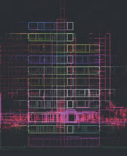
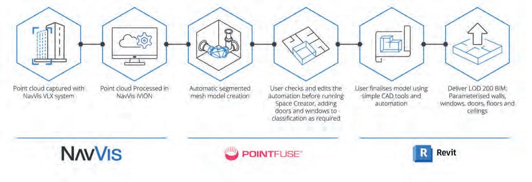
she says. She navigated inside each individual room and verified or identified doors, walls, furniture, windows, and other important elements. Meanwhile, she kept the original point cloud open in NavVis IVION as a visual reference.
“After that, we went to the BIM Space Management module and produced a 3D model automatically. Then I just adjusted and positioned each window and door. I worked in parallel in NavVis IVION, navigating to each room and streaming the measurements to verify positioning.”
After she completed the alignment of each floor, she exported an IFC file from PointFuse Pro to easily upload into Revit for the final clean-up and modelling, again with no need for further alignment. From there, the BIM model was quickly completed to the client’s specs.
BIG SUCCESS AND A FUTURE OUTLOOK IBKS says the NavVis and PointFuse workflow exceeded expectations and made what was initially a daunting task, very easy and smooth. For one, the mobile scanning was fast. The team was in and out of each tower in only 10 days and were happy that they didn’t need to return after the initial capture. The speed of the mobile mapping workflow also helped reduce disruption to the medical personnel on-site. “Even though we scanned after hours, there were doctors and nurses in some of the offices,” notes Haidar. “And they had to step out for only three minutes for us to complete the scan and get back. To them, it was like a welcome coffee break. Almost everybody was surprised by how quickly we got out of their space.”
And that speed didn’t mean a drop in accuracy or data quality. “We’re actually seeing some really high precision using mobile mapping in spaces like long corridors,” says Lipsey. “And apart from just a few very minor artifacts, everything came out really clean. I think we’ll be able to use NavVis VLX on a much larger scale than we anticipated.”
As for the software workflow, Lipsey says it was definitely up to the challenges posed by scan-to-BIM work for large medical facilities. NavVis IVION reduced the initial processing time to 4 hours per floor (roughly 16,000 sq feet). PointFuse Pro reduced the “scan-toRevit-model” time to only 12 hours per floor. It also reduced the size of the point cloud files by over 66%, saving a lot of storage space and speeding up transfers significantly.
IBKS’ innovative workflow also managed the complex alignment with no problem. “In fact, I think it enables us to do as many storeys as we need,” says Lipsey. “We could start with alignment in NavVis IVION, bring the data accurately into PointFuse Pro, and then Revit, without having to do any further translation.”
“This is a great testament to how both of the products work together,” concludes Haidar. “We’ve seen some tremendous success here.”
ABOUT THE AUTHOR
Sean Higgins is an independent technology writer, former trade publication editor, and outdoors enthusiast. He believes that clear, buzzword-free writing about 3D technologies is a public service.
