11 minute read
Data Quality Factors for Marine UXO Surveys


Researchers Involve Stakeholders to Define Unexploded Ordnance Survey Requirements
Data Quality Factors for Marine UXO Surveys
The detection of unexploded ordnance (UXO) in the sea is a demanding task. UXO survey data are acquired using a set of different sensors in different configurations and can span large areas. To make sure that the resulting highly complex dataset is fit for purpose, a welldefined workflow is crucial. Researchers of the BASTA project are therefore developing quantitative data quality factors to indicate how survey data should be acquired for the detection of a specified reference object.
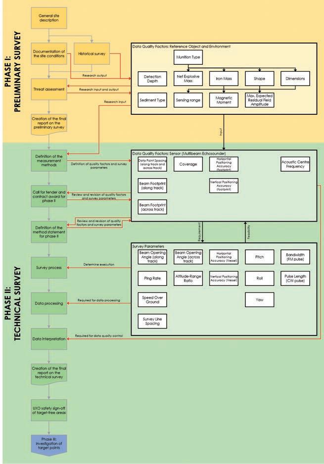
Figure 1: BASTA UXO survey quality factors flow chart – multibeam echosounder.
Munition or unexploded ordnance (UXO) in the sea poses a threat during offshore work such as pipeline or platform construction, as well as to the marine environment. If UXO detection and clearance activities are executed erroneously, managed poorly or even omitted, UXO can threaten the lives of construction workers, the construction schedule, the marine fauna, and the public image of the parties involved. In response to these challenges, Frey (2020) developed the Quality Guideline for Offshore Explosive Ordnance Disposal (EOD). The guideline addresses the four phases of EOD: (I) a desk-based preliminary survey of historical data, (II) a technical survey in the field, (III) an investigation of suspected UXO sites, and (IV) UXO clearance and disposal. Other guidelines on marine UXO surveys or on hydroacoustic mapping that are relevant to munition surveys have been published by OWA (2020), IHO (2020), NOAA (2019) and IOGP (2009). All of these documents largely consist of a qualitative description of the workflows for marine geophysical surveys, and to some extent for UXO campaigns. GEOMAR and north.io are now working on a method to quantitatively describe a
Parameter Variable Unit Example Reference Object and Environment
Definition
Munition Type Shape Dimensions (d1<d2<d3) di [-] 155mm shell BL Mark VII (nation: GB) The specific type of munition. [-] spheroidal [m] 0.15, 0.15, 0.60 The geometric shape that best describes the reference object. The measures of the three dimensions of the munition type in ascending order (e.g. width, height, length).
Detection Depth Sediment Type z [m] 1 [-] sand, clay The depth below the seafloor down to which the reference object shall be searched for. All sediment types that are present within the survey area.
Iron Mass M [kg] 34,9 The weight of the amount of iron in the reference object.
Net Explosive Mass Magnetic Moment NEM [kg] 10,5 m [Am²] 0.4 - 2 The weight of explosive material in the reference object. The magnetic moment that is estimated/expected for the reference object.
Max. Expected Residual Field Amplitude at 2,3,4,5,6,8,10 m B [nT] 41, 12, 5, 2.5, 2, 1, 0.5 The maximum residual field amplitude for the reference object which either was modelled under specified assumptions (modelled shape, orientation, remanent magnetization) or was measured in a field test.
Sensing Range l [m] l = l’(S/N ≥ 3) The maximum distance between sensor and reference object at which the signal can still be detected, where S=B and noise N is determined from a field test.
Detection Parameter
Accuracy Parameter
Signal Parameter
Quality Factor Variable Unit BASTA value/equation for detection
Data Point Spacing (along-track and across-track) x [m] x ≤ d1/3
Beam Footprint (along-track) Fal [m] Fal ≤ d1
Beam Footprint (across-track) Fac [m] Fac ≤ d1
Coverage Horizontal Positioning Accuracy (footprint)
Vertical Position Accuracy (footprint) n [-] n ≥ 100%
δh
δv
[m] if d1 > 0.5 m then δh < 1 (according to THU of IHO-S44 Exclusive Order) if d1 < 0.5 m then δh ≤ 2*d1 [m] if d1 > 0.5 m then δv < √(a²+(b*zw)² (according to TVU of IHO-S44 Exclusive Order) if d1 < 0.5 m then δv ≤ d1/2 Acoustic Centre Frequency f [kHz] f > 300
Multibeam Echosounder
Definition
The data point spacing of soundings in across track and along track direction. Threshold relative to Reference Object parameter d1=shortest dimension. The extent of the footprint of the acoustic beam at the seafloor in along track direction. Threshold relative to Reference Object parameter d1=shortest dimension. The extent of the footprint of the acoustic beam at the seafloor in across track direction. Threshold relative to Reference Object parameter d1=shortest dimension. The area covered by the measurements relative to the total survey area. The horizontal positioning accuracy of the footprint, accounting for errors of GNSS, offsets, motion and sound velocity. Threshold relative to Reference Object parameter d1=shortest dimension.
The vertical positioning accuracy of the footprint, accounting for errors of GNSS, offsets, motion and sound velocity (with a=0.15 m, b=0.0075 according to IHO-44S Exclusive Order and zw=water depth). Threshold relative to Reference Object parameter d1=shortest dimension.
The acoustic centre frequency of the signal that is emitted by the sensor.
Table 1: Example reference object and multibeam sensor quality factors with the threshold values that are partly related to the reference object.
survey by defining data quality factors. Using such quality factors in the workflow can improve data handling, as more time can be spent on data analysis and interpretation. As multi-sensor datasets become larger and more complex, a well-defined workflow and consistent threshold criteria for data quality will increase project transparency and trust in the results. In addition, clear definitions will improve the communication between all partners involved in the UXO projects, from the project manager to surveyors and data analysts.
METHODOLOGY
The BASTA researchers apply the following steps to define the data quality factors: 1. A literature review of all existing guidelines.
Based on this information, an initial table of data quality factors for the reference object and for different relevant sensors (multibeam echosounder, side-scan sonar, sub-bottom profiler, magnetics) could be developed. 2. This initial table of data quality factors was transformed into a questionnaire and sent to 125 experts in the field of marine UXO
surveys. An updated table was then created based on the responses. 3. Digital stakeholder workshops were held to discuss the data quality factors and threshold values that define whether the data are fit for purpose to detect a specified reference object. Two workshops each for magnetic and hydroacoustic sensors were organized, and 29 experts participated in the discussions. The workshops led to the definitive agreement on 57% of the discussed data quality factors, while the remainder is still under discussion. Again, the table of data quality factors was updated. 4. In a final event, that took place during the
Kiel Munitions Clearance Week 2021 (www. munitionclearanceweek.org), the remaining, not yet agreed upon, quality factors were discussed furhter. The evaluation is in progress.
DATA QUALITY FACTORS – PRELIMINARY RESULTS
We distinguish between the reference object data quality factors and sensor data quality factors. In the process described above, these were identified by answering the following questions: • e erence o ect: ic re erence o ect data quality factors need to be provided after the preliminary survey and before phase II (the technical survey)? • Sensors: ic sensor ata ualit actors are important to determine whether the survey data are fit for the purpose of detecting a specified reference object?
Once these questions had been answered, a standardized UXO survey workflow that is based on transparent data quality factors could be developed. A preliminary version of the workflow for multibeam surveys is illustrated in Figure 1.
The flow chart shows that the historical survey and the documentation of the site conditions are the principal inputs to the definition of a reference object. This is the smallest object that needs to be detectable in the survey data and is commonly defined following a threat or risk assessment. All reference object quality factors
are therefore an output of the preliminary survey (Phase I). Note that not all reference object quality factors are relevant for multibeam systems, as the reference object needs to be defined (and thus its quality factors determined) before the survey planning begins.
The reference object and its properties are the inputs to the technical survey (Phase II), in which measurement methods are defined and subsequently reviewed and revisited by the client and the contractor during the tendering and the definition of the method statement for the survey. In addition, a number of survey parameters define how the survey process itself is executed. The method statement must therefore balance data quality requirements and the survey feasibility requirements. Knowledge of all data quality factors is relevant for the subsequent data processing and data interpretation processes.
Similar workflows were prepared for all sensors that are commonly used in UXO detection surveys, and are available on the BASTA project website (www.basta-munition.eu/events). These include the multibeam echosounder, side-scan sonar, sub-bottom profiler and magnetometer (Frey, 2020). More recent techniques such as electromagnetics, synthetic aperture sonar and possibly chemical sensors will be defined in the future.
For the sensor data quality factors, threshold values need to be defined for the sensor. These act as an objective and theoretical requirement for the detection of the specified reference object. Since reference object data quality factors form the input to the technical survey, they act as controlling variables for many threshold values of sensor data quality factors. Table 1 shows the preliminary data quality factors for an example reference object as well
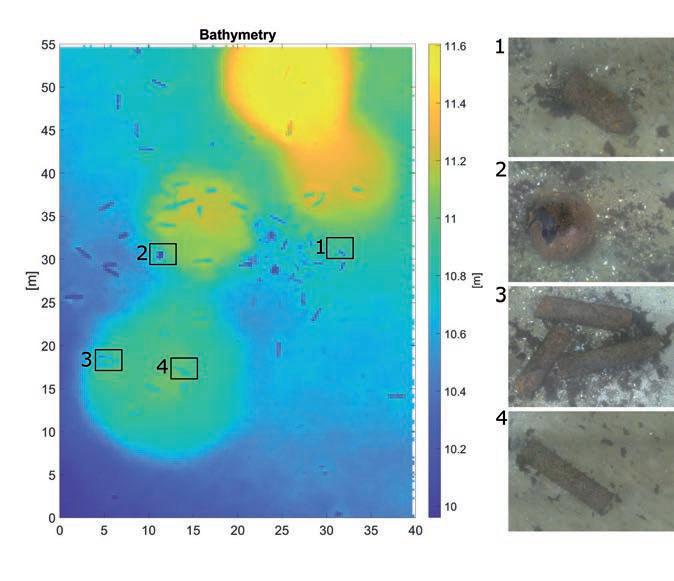
Figure 2: Multibeam data and photographs of munitions objects in the German dump site Kolberger Heide.
Figure 3: A multibeam dataset demonstrating the application of data quality factors. The quality factors are scaled to the thresholds defined in Table 1, where the quality factor exactly meets the threshold for a value of 1. Daniel Wehner is a geophysical researcher currently working at north.io. He received a PhD from the Norwegian University of Science and Technology (NTNU) in Trondheim in 2019, for his work on marine seismic acquisition and geophysical monitoring systems. His research interests also include marine geosciences, geophysical measurement techniques and engineering geophysics.
Torsten Frey is a researcher at GEOMAR Helmholtz Centre for Ocean Research Kiel. He is the lead author of the Quality Guideline for Offshore Explosive Ordnance Disposal (EOD) and continues to research new opportunities to improve the quality and efficiency of the EOD process. In his current research, he focuses on risk-based decision-making during UXO clearance operations.
Mareike Kampmeier is a geoscientist at GEOMAR Helmholtz Centre for Ocean Research Kiel. Her research focus is on UXO detection via hydroacoustic systems and high-resolution photo mosaics. She is working on establishing a workflow for automated munition detection and making a mass estimation of dumped munitions in German waters.
as the resulting threshold values for multibeam data quality factors, which need to be defined before a survey can commence. Detailed tables of data quality factors for all sensors considered so far can be found on the BASTA project website.
PRACTICAL APPLICATION
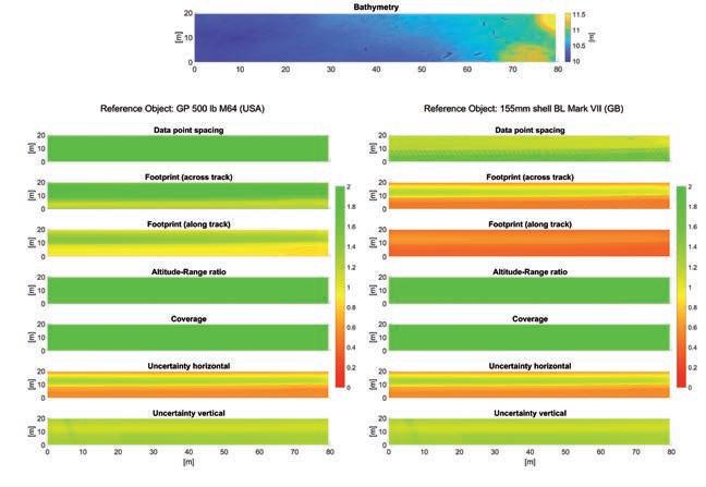
Figure 2 shows an example of a multibeam dataset of the German dump site Kolberger Heide and of a subsequent AUV-based camera survey. Several different UXO objects can be identified in the multibeam data, but how do we know whether all the UXO objects on the seafloor have been detected, or whether some smaller objects have been missed? This question is particularly difficult to answer for datasets that span large areas with varying water depth and seabed conditions. However, the definition of quality factors can help answering this question. Figure 3 illustrates the data quality factors computed on the same real multibeam dataset for two differently sized UXO objects. The quality factors are computed relative to the threshold values defined in Table 1. The dataset seems to be generally sufficient for the detection of an aerial bomb (left column: GP 550 lb M64). On the other hand, the computed footprints indicate that the smaller object (right column: 155mm shell BL Mark VII) would probably be missed in large parts of the survey area (please note that this working example is meant to illustrate the idea). Similar threshold values can be calculated for the other sensors that are listed in the workflows. Once the data quality factors have been finalized, the calculation presented in this paper will be made available as features via AmuCad.org and TrueOcean.io.
CONCLUSION
A well-defined workflow and commonly agreed data quality factors for geophysical survey data can improve the project transparency for UXO surveys, as illustrated in the example. For complex datasets in particular, which include numerous sensors that need to be understood by multiple parties involved in a project, such guidance can facilitate communication between stakeholders. Since acceptance among industry experts is crucial for the future application of the data quality factors presented in this article, their definition is supported by stakeholders.
References
Frey, Torsten (2020): Quality Guideline for Offshore Explosive Ordnance Disposal. 1st Edition. Berlin, Zurich, Vienna: Beuth Verlag GmbH. IHO (2020): IHO S-44 Standards for Hydrographic Surveys, 6th Edition, Monaco: International Hydrographic Organization. IOGP (2009): Guidelines for the conduct of offshore drilling hazard site surveys, Version 2.0, London: International Association of Oil & Gas Producers. NOAA (2019): Hydrographic Surveys Specifications and Deliverables, National Oceanic and Atmospheric Administration. OWA (2020): Guidance for geophysical surveying for UXO and boulders supporting cable installation, Offshore Wind Accelerator.