19 minute read
aNNEX 2: OPPORTUNITY TO COMMENT
Within the context of the 2020 Pantanal fires – many reportedly thought to have been deliberately and illegally lit by ranchers in defiance of regional and federal bans – Greenpeace provided the meat processors and, where possible, ranchers named in this report with the opportunity to comment prior to publication on the historic trade links it had established between ranchers with operations in the Pantanal and specific slaughterhouses, as well as any legal/policy irregularities (eg embargoes, irregular CAR status) it had identified in those ranchers’ operations. The aim was to help ensure the accuracy of all findings. Greenpeace contacted the meat processors on 4 January 2021, asking them to:
1. Confirm the historic trade information linking them to the named ranchers and confirm and explain any identified legal/ policy irregularities associated with the named ranchers
2. Provide the most recent date on which they had sourced cattle from the named ranchers
3. Identify the steps they had taken to review the compliance of their current suppliers, given the extent of the fires in the Pantanal in 2020 and federal and state bans on deliberate use of fire
4. Verify whether – following review – the decision had been taken to exclude any of the named ranchers from their supply chains
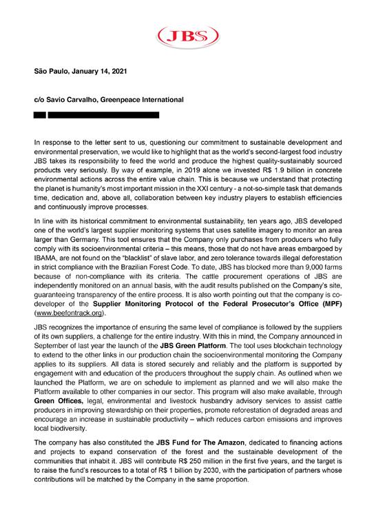
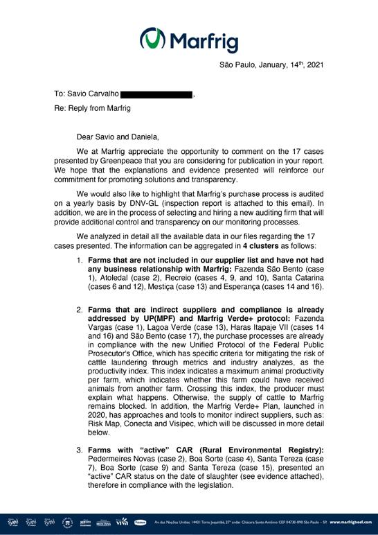
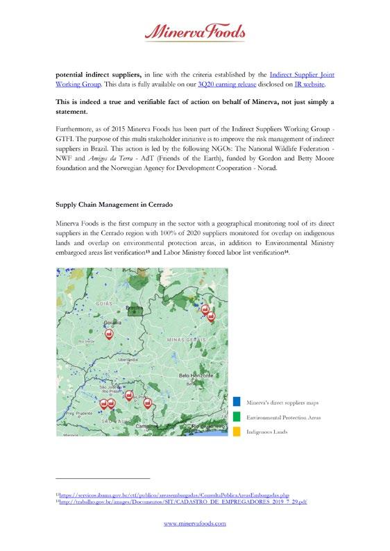
The letters received in reply are reproduced below. Copies of the full responses are also available online, at https://drive.google. com/drive/folders/14lO83hGPwMlCxfX7glurOoztPNNHdHT?usp=sharing.


aNNEX 3: MaPPING aND DaTa REFERENCES
LaND COVER:
MapBiomas produces annual statistics and high-resolution maps of land use change for Brazil, including the Pantanal,414 covering 1985 to the present. The 30-metre-resolution maps use automatic classification through machine learning based on Landsat imagery. Source: MapBiomas Project – Collection 5 of the Annual Series of Coverage and Land Use Maps in Brazil, accessed October 2020 through the link https://plataforma.mapbiomas.org/
LIMITaTIONS
2019 is the latest year for which data are readily available. Detailed satellite analysis or a delay would be required to identify 2020 land cover prior to fires. Given the indicative nature of the analysis, this is not a profound limitation.
FIRE HOTSPOTS aND BURNED aREaS (BURN SCaR):
Fire hotspot data were downloaded from INPE’s Programa Queimadas415 and include data from all confidence levels for the INPE reference satellite, MODIS Aqua.416
The burn scar dataset, covering 1 July to 27 October 2020, was provided to Greenpeace Brazil as a KML file by LASA, part of a joint initiative between the Universidade Federal do Rio de Janeiro in Brazil and the Instituto Dom Luiz at the University of Lisbon, Portugal. The model uses NASA VIIRS observations to produce near-real-time (NRT) analysis of burned areas at 500m resolution.
LIMITaTIONS
Fire hotspots are thermal anomalies (ie unusually hot areas) detected by satellites. It is important to distinguish hotspots from actual fires – they could represent fires or they could be hot tin roofs, although the occurrence of false positives is relatively low. Within forest areas, accuracy depends on the size of the fire, the density of the canopy and proximity to built-up areas.
Fires may have occurred undetected by the systems used for this analysis because of data capturing intervals, because of clouds or haze or tree cover obstructing detection, or because the fire was too cool at the surface to be detected. Combining the alert data from different satellites such as MODIS Aqua and VIIRS, which pass over at different times during the day or have different resolutions, increases the chances of capturing fires within affected areas. Conversely, it will inevitably lead to the inclusion of some false positives. There is no single perfect fire detection system available at present.
NRT burn scar mapping is recent technology, so making comparisons with previous years, for instance to assess the extent of the burned area, is not always feasible. In December 2020, MapBiomas launched an initiative to provide consolidated information on the area burned each year from 2000 to 2019.417 Unfortunately, due to methodological differences, the data are not comparable with the LASA maps.
LASA estimates that its burned area maps have a 20% margin of error,418 meaning the resulting analysis should be considered indicative only. They represent the best current available information.
THE LOCaTION aND BOUNDaRIES OF THE PaNTaNaL BIOME, INDIGENOUS LaNDS aND PROTECTED aREaS:
In 2019, IBGE published at a scale of 1:250,000 a revision to its 1:5,000,000 map of the Pantanal and other biomes. Source: Biomas_250mil.zip, available under Downloads > vetores at https://www.ibge.gov.br/geociencias/informacoesambientais/15842-biomas.html
FUNAI publishes maps showing the locations of Indigenous lands and what stage in the demarcation procedure they have reached. Source: http://www.funai.gov.br/arquivos/conteudo/cggeo/ pdf/terra_indigena.pdf
Conservation units (unidades de conservação, UCs) are protected areas on public land within which economic activities are forbidden or highly controlled. There are several types of conservation unit in Brazil, including fully protected units (unidades de proteção integral), such as national or state parks or biological reserves, and private reserves (Reserva Particular do Patrimônio Natural, RPPN), which allow ‘sustainable use’. The dataset used in this analysis is a compilation of several datasets from several sources.
ICMBio: The Instituto Chico Mendes de Conservação da Biodiversidade (Chico Mendes Institute for Biodiversity Conservation) is the branch of the Ministry of the Environment charged with managing Brazil’s federal conservation units and protecting its natural heritage and biodiversity. Through its Sistemas Informatizado de Monitoria de RPPN (SIMRPPN), it makes available maps of some RPPN conservation units. Source: https://sistemas.icmbio.gov.br/simrppn/publico/
IHP: The Instituto Homem Pantaneiro is an NGO working for the preservation of the Pantanal biome and culture, which provides detailed maps of certain RPPNs. Source: https://www.institutohomempantaneiro.org. br/relatorios –> Relatório RPCSA 2019 p17 illustrates the boundaries of RPPN Acurizal, RPPN Fazenda and RPPN Rumo ao Oeste (direct download https://drive.google.com/file/d/1EVAJx x6J02XcPY8Fw7cF28hzGamrx7Lq/view?usp=sharing)
INCRA: The Instituto Nacional de Colonização e Reforma Agrária (National Institute for Settlement and Agrarian Reform) is the federal agency responsible for the administration of land reform issues, including demarcating land for new farming settlements, registering certified properties and maintaining a georeferenced database of such properties. Brazilian law mandates that every rural property must be professionally surveyed and registered with INCRA by 2025. INCRA makes available maps of properties with rural property certificates (Certificação de Imóveis Rurais). Information in the INCRA database allows localisation of RPPNs for which no official geographical information is available. Source: https://certificacao.incra.gov.br/csv_shp/export_shp. py
INTERMAT: The Instituto de Terras do Mato Grosso is the land institute for the state of Mato Grosso and is responsible for implementing the state policy on the disposal of public lands. It makes available digital maps of all state conservation units in Mato Grosso. Source: http://www.intermat.mt.gov.br/-/11303036-basescartograficas
MMA: The Ministério do Meio Ambiente (Brazilian Ministry of the Environment) makes available shapefiles of established federal conservation units (both fully protected and areas of sustainable use). Source: http://mapas.mma.gov.br/i3geo/datadownload.htm; also available from INPE TerraBrasilis at http://terrabrasilis.dpi. inpe.br/download/dataset/pantanal-aux/vector/conservation_ units_pantanal_biome.zip
SICAR: The Sistema Nacional de Cadastro Ambiental Rural (Federal Rural Environmental Registry), which is under the Serviço Florestal Brasileiro (Brazilian Forest Service), a branch of the Ministério da Agricultura, Pecuária e Abastecimento (Ministry of Agriculture, Livestock, and Food Supply), makes available the self-reported boundaries of rural properties. Information in the SICAR database allows localisation of RPPNs for which no official geographical information is available. Source: https://www.car.gov.br/publico/municipios/downloads
LIMITaTIONS
Although Brazil’s Constitution guarantees Indigenous land rights on ancestral lands, the government has delayed the process of land demarcation for decades. New policies pave the way for land claims made within Indigenous territories to gain official recognition.419 Equally, conservation units, particularly at state level, are extensively overlapped by CAR registrations. In brief, the legal status and enforcement of legal standing of these areas is not guaranteed. This is less an issue of data deficiency than an issue of public policy.
THE LOCaTIONS OF CaTTLE RaNCHES:
Under Brazil’s Forest Code, rural property holders are required to provide information on their properties to the Rural Environmental Registry (Cadastro Ambiental Rural, CAR), including the property owner and georeferenced property
boundaries. Official data on these georeferenced property boundaries are publicly available from federal and state-level sources. Sources: Federal CAR data: https://www.car.gov.br/#/consultar Mato Grosso CAR data: https://monitoramento.sema.mt.gov.br/ simcar/tecnico.app/publico/car Mato Grosso do Sul CAR data: https://www.imasul. ms.gov.br/cadastro-ambiental-rural-car-ms/ and https:// www.pinms.ms.gov.br/portal/home/webmap/viewer. html?webmap=3b0c2ba8c1a34c46ba6167d35d2c14ce
LIMITaTIONS
Registration with the CAR is mandatory in Brazil under the Forest Code, and CAR registrations are frequently used to stake and secure land claims through evidence of agricultural use, even though they do not constitute legally binding land title.420 The original deadline for registration of rural properties was May 2016, but this has been extended several times as not all property owners have complied. Additionally, much of the self-reported information has not yet been verified, meaning that land claims may overlap with public, protected or Indigenous lands. Further, the self-declared property boundaries may be revised to avoid liability for violations of the Forest Code, which specifies the minimum proportion of natural vegetation that must be maintained within a property.421 Other challenges with the dataset include growing gaps in the embedded attributes, making the linking of a rancher with a specific CAR registration and thence other data difficult. Different ranches may have the same name, certain surnames are extremely common and the official owner of a ranch may not be the named individual managing trade.
Despite its limitations, the CAR database is the main reference used by companies, civil society and federal inspectors to monitor properties for policy or legal violations.
THE LOCaTION OF CaTTLE SECTOR INFRaSTRUCTURE:
The image processing laboratory at the Universidade Federal de Goiás (Laboratório de Processamento de Imagens e Geoprocessamento, Lapig) makes available a number of data layers including point locations for grain silos, soya crushing facilities and slaughterhouses. Source: https://www.lapig.iesa.ufg.br/lapig/index.php/ produtos/dados-geograficos
The Ministry of Agriculture, Livestock, and Food Supply provides public information on SIF-registered beef processing facilities. Sources: SIF consultation portal: http://bi.agricultura.gov.br/reports/ rwservlet?sigsif_cons&estabelecimentos.rdf&p_id_area=1 List of establishments: http://extranet.agricultura.gov.br/sigsif_ cons/!ap_estabelec_nacional_cons
ENVIRONMENTaL OR HUMaN RIGHTS SaNCTIONS LINKED TO RaNCHES aND THEIR OWNERS:
Brazil’s Ministry of Labour and Employment (Ministério do Trabalho e Emprego, MTE) publishes a ‘Dirty List’ of farms identified as using or having used slave labour or labour analogous to slavery. Source: https://sit.trabalho.gov.br/portal/images/CADASTRO_ DE_EMPREGADORES/CADASTRO_DE_EMPREGADORES.pdf
INFORMaTION ON ENVIRONMENTaL VIOLaTIONS aND MaPS OF EMBaRGOED aREaS:
IBAMA publishes information on embargoed areas as well as other infractions and fines, with details on the location, the offence and the offender. Additional information on infractions is embedded in the CAR shapefiles. The Mato Grosso state environment agency also provides maps of embargoed areas and an online consultation website for details of specific cases. ICMBio makes available some information as KMZ files. Sources: IBAMA consultation website: https://servicos.ibama.gov.br/ctf/ publico/areasembargadas/ConsultaPublicaAreasEmbargadas. php and https://siscom.ibama.gov.br, Dados Geoespaciais > Camadas > Autos de Infração (shapefiles downloaded 11 November 2020) Mato Grosso embargo map (SEMA - Navegador Geográfico Unificado): https://monitoramento.sema.mt.gov.br/simcar/ tecnico.app/publico/mapa (downloaded 13 November 2020) Mato Grosso consultation website: http://www.protocolo.sad.mt.gov.br/consulta/cp.php ICMBio: https://www.icmbio.gov.br/portal/ geoprocessamentos/51-menu-servicos/4004-downloadsmapa-tematico-e-dados-geoestatisticos-das-uc-s
LIMITaTIONS
Information on environmental violations is not easy to consult – CAR registration numbers or CPJ numbers, for instance, are needed. The information provided also is often piecemeal; fines are not always linked to the relevant CAR number, and a search by CPF/CNPJ number may not reveal all the properties linked to the individual that have been logged for violations. Further, maps of embargo areas are not always readily available, and Mato Grosso do Sul allows only registered users to access its CAR database. As such, review of these data sources provides indicative information only and leaves potential gaps, meaning
the failure to find violations cannot be considered a guarantee of full legal compliance.
MEaT PROCESSOR TRaCEaBILITY WEBSITES:
One of the key pledges the major beef processors made under the 2009 G4 Agreement was to deliver a tracking system enabling monitoring, verification and reporting of the origins of cattle across the entire supply chain.422 As part of the agreement, they undertook to provide proof of their compliance. To this end, JBS set up a ‘Guarantee of origin’ website423 that enabled consumers and civil society organisations to check the farm names, coordinates, ownership and other details of direct suppliers from which individual consignments of beef originated.424 Marfrig and Minerva have or had similar websites. The three companies have progressively decreased the comprehensiveness and usefulness of the information presented on their websites – indeed, Minerva’s website no longer provides any information.425 Sources: Friboi (JBS): https://www.friboi.com.br/sustentabilidade/garantia-de-origem Marfrig: https://rastreabilidade.marfrig.com.br/GadoLegal/ Minerva: http://ri.minerva.ind.br/minerva2012/web/conteudo_pt.asp?conta=28&id=152483&tipo=41008&idioma=0
TRaDE FROM PROCESSING FaCILITIES TO THE GLOBaL MaRKET aND/OR CONSUMER GOODS aND FaST FOOD COMPaNIES:
General international trade data are provided by, for example, the Trase supply chain transparency initiative,426 which currently shows trade in beef for the period 2015–2017 from municipalities or biomes, through exporter groups (dominated by JBS, Marfrig and Minerva), to importers and countries. Trade data on exports from individual facilities covering the period 1 January 2019 to 31 October 2020 were obtained from Panjiva (based on customs and shipping data). Panjiva provides subscription-based access to import and export data on commercial shipments from selected countries, including Brazil. Other trade links between the beef processors and consumer companies were established through review of annual reports427 and media sources, and through field investigations. Sources: Trase: https://trase.earth/flows?toolLayout=1&countries=27&commodities=46&selectedContextId=6&selectedColumnsIds=0_14-1_22-2_9-3_16 Panjiva: https://panjiva.com/data/brazil-trade-data Trase trade data are readily accessible, but not up to date. Given the highly dynamic nature of current trade, data from 2017 cannot be assumed to be a perfect indication of trade in 2020. Also, the data is not as granular as it could be – although its analysis is based on GTAs, Trase has chosen to show supply originating from different municipalities and exporters but does not detail production facilities or their individual suppliers.
Shipping/customs data are not necessarily comprehensive, with an increasing number of exporters rumoured to be seeking means to ensure their information is not collected or made available. Panjiva mentions that companies domiciled in the USA can keep their names hidden.428
GLOSSaRY – TERMS aND aCRONYMS
CAR (Cadastro Ambiental Rural/Rural Environmental Registry) – Under Article 29 of Brazil’s Forest Code (see entry below), self-reported registration of rural properties (including identification of property boundaries) with the CAR is mandatory. The aim of this requirement is to establish a georeferenced database of all properties to be used for monitoring and enforcement of compliance with environmental regulations, as well as environmental and economic planning. Registration is one of the prerequisites for rural producers to have access to credit, following the rules of the Forest Code.
Deforestation and land clearance – For the purposes of large-scale or rapid monitoring, land use change classified as loss of native vegetation by satellite-based deforestation alert systems such as DETER and PRODES, along with initiatives like the MapBiomas Project (see entry below) and other sources of high-resolution satellite imagery.
Embargo – IBAMA (see entry below) publishes a list of farms that have breached environmental legislation such as the Forest Code (see entry below) – eg by carrying out illegal deforestation – and that are prohibited (embargoed) from producing in a specified area of their landholding (which may comprise the whole farm or only part of it) until they regularise their situation, for example through payment of a fine and land restoration.
Forest Code – Brazil’s Forest Code is the main legislation regulating conservation on private lands, mandating how and where native vegetation may be cleared. The law establishes two types of conservation area on private land: Legal Reserves and Areas of Permanent Protection (APPs). Legal Reserves are portions of landholdings where the native vegetation must be preserved, with their extent depending on the property’s size and location (within the Legal Amazon 80% of the property if forested, 35% if in the Cerrado and 20% if on grassland must be set aside as Legal Reserves; outside the Legal Amazon only 20% of the property is required to be set aside). APPs are areas such as the borders of waterways or steep slopes that have been identified as critical to essential ecosystem functions, such as preserving hydrological resources or biodiversity, ensuring geological stability, facilitating the movement of fauna and flora and protecting the soil. In areas classified as pantanal wetlands (pantanais) or flood plains (planicies pantaneiras) – which covers about 16% of the Brazilian Pantanal – permits for clearance may only be issued for activities deemed ‘sustainable and ecological’, which includes traditional cattle raising.
FUNAI (Fundação Nacional do Índio/ National Indian Foundation) – The federal agency (under the Brazilian Ministry of Justice) responsible for establishing and implementing policies relating to Indigenous Peoples. FUNAI is charged with mapping out and protecting lands traditionally inhabited and used by Indigenous communities and preventing invasions of their lands.
IBGE (Instituto Brasileiro de Geografia e Estatística/ Brazilian Institute of Geography and Statistics) – The public agency responsible for official collection of data including cartographic and environmental information. Part of the Ministry of the Economy.
IBAMA (Instituto Brasileiro do Meio Ambiente e dos Recursos Naturais Renováveis/Brazilian Institute of the Environment and Renewable Natural Resources) – The Ministry of the Environment’s administrative arm, responsible for monitoring and enforcement activity concerning the use and protection of natural resources. IBAMA analyses applications and issues licences for any project that may harm or degrade the environment, and applies sanctions for breaches of the standards of environmental preservation. It also publishes a list of farms that have breached environmental legislation such as the Forest Code.
ICMBio (Instituto Chico Mendes de Conservação da Biodiversidade/Chico Mendes Institute for Biodiversity Conservation) – The branch of the Ministry of the Environment charged with managing Brazil’s federal conservation units and protecting its natural heritage and biodiversity.
Illegal deforestation or land clearance – According to Article 43 of federal decree 6.514/2008 it is an administrative infraction to ‘destroy or damage forests or other forms of natural vegetation or use them in violation of the protection rules in an area considered to be of permanent preservation, without authorisation from
the competent authority’. Thus, any land clearance that occurs in such an area without authorisation from IBAMA or the relevant state environmental agency is illegal. For monitoring purposes, notable indicators of potential illegal deforestation or land clearance events would be any clearance that occurs inside a Legal Reserve or APP. The use of fire for land management and clearance – however environmentally destructive it may be – is only illegal during times of state or federal ban. In 2020, the use of fire in Brazil was prohibited by a presidential decree that came into force on 16 July for a period of 120 days; regional prohibitions on dry-season burning were also in place in Mato Grosso, from 1 July to 30 September 2020, and Mato Grosso do Sul, extending for 180 days from late July 2020.
INCRA (Instituto Nacional de Colonização e Reforma Agrária/National Institute for Settlement and Agrarian Reform) – The federal agency responsible for the administration of land reform issues, including demarcating land for new farming settlements, registering certified properties and maintaining a georeferenced database of such properties. Brazilian law mandates that every rural property must be professionally surveyed and registered with INCRA by 2025.
INPE (Instituto Nacional de Pesquisas Espaciais/National Institute for Space Research) – A research unit of the Brazilian Ministry of Science and Technology, responsible among other things for satellite monitoring of deforestation and fires in Brazil. President Bolsonaro’s administration has signalled its intent to transfer this role, fulfilled by INPE for the past three decades, to Brazil’s military – a move critics fear will decrease transparency and weaken enforcement efforts.
LASA (Laboratório de Aplicações de Satélites Ambientais/Laboratory for Environmental Satellite Applications) – Part of the Department of Meteorology at the Federal University of Rio de Janeiro, LASA has developed a satellite-based warning system that tracks the daily evolution of burned area in the Pantanal and Cerrado (a joint initiative with the Instituto Dom Luiz from the University of Lisbon, Portugal). Data from LASA were used in the present analysis to determine the extent of burned areas.
MAPA (Ministério da Agricultura, Pecuária e Abastecimento/Ministry of Agriculture, Livestock, and Food Supply) – Responsible for formulating and implementing policies for agribusiness development. Provides public information on SIF-registered beef processing facilities (see below). MapBiomas – The MapBiomas Project is an initiative involving universities, NGOs and technology companies (including Google), working together to understand Brazilian territory transformations based on the annual mapping of land cover and land use from 1985 to the present. Data from MapBiomas were used in the present analysis to determine the impact of burned areas on other land types.
MMA (Ministério do Meio Ambiente/Ministry of the Environment) – Responsible for formulating and implementing national environmental policies. Dismantling the MMA was one of Bolsonaro’s campaign promises, and while he has stopped short of this goal his administration has transferred many of the ministry’s responsibilities to other government agencies. IBAMA and ICMBio (see above) both fall under the MMA and have been significantly weakened since he took office.
MPF (Ministério Público Federal/Federal Public Ministry) – Public agency led by the Attorney General of the Republic. The function of the MPF is to defend the social and individual rights of citizens before the Supreme Federal Court, Superior Court of Justice, federal regional courts and federal judges. The MPF also acts preventively, out of court, through recommendations and public hearings and the negotiation of Terms of Adjustment of Conduct (Termos de Ajuste de Conduta, TACs).
SIF (Serviço de Inspeção Federal/Federal Inspection Service) – Organised by MAPA and overseen by the Department of Inspection of Animal Origin Products (Departamento de Inspeção de Produtos de Origem Animal, DIPOA), the SIF is responsible for ‘ensuring the quality of edible and inedible animal products intended for the domestic and foreign markets and the suitability of imported products’. The system operates in approximately 5,000 establishments across the country, each identified by a SIF number. The seal on a facility’s products is meant to indicate that they are of safe animal origin and meet the criteria required by legislation; it also enables traceability of those products back to the facility where they originated. SIF-registered facilities are able to trade throughout the country (unlike those registered with the state or municipal inspection services, which can trade only locally) and, if they meet additional criteria, export abroad.
UC (unidade de conservação/conservation unit) – A protected area on public land, within which economic activities are forbidden or highly controlled.


