&PARKS TRAILS
MOOSE LOOP CHALLENGE
TOP GREENBELT TRAILS
PARK-OF-THE-YEAR: KINCAID
Featuring Kincaid Park Beach Access, pg 10
Local Artists + Local Writers

MOOSE LOOP CHALLENGE
TOP GREENBELT TRAILS
PARK-OF-THE-YEAR: KINCAID
Featuring Kincaid Park Beach Access, pg 10
Local Artists + Local Writers
The Anchorage Park Foundation is a community-based nonprofit that mobilizes public support and financial resources to improve Anchorage’s parks, trails, and recreation opportunities.
Schools on Trails: connecting students to nature in nearby parks
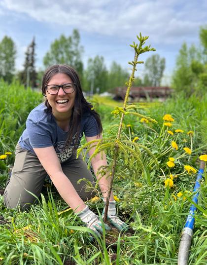
Youth Employment in Parks (YEP): summer conservation corps program for young adults provides meaningful training, employment, community engagement, and outdoor education.
Inclusive Play: making playgrounds accessible to children and adults of all abilities.
Trails Initiative: community advocacy for active transportation through safe, connected streets, and trails.
Indigenous Place Names Project: bringing Dena’ina place names, stories, and signage to parks and trails.
Challenge & Forest Grants: granting financial support to community-initiated park and landscape improvement projects.
Fiscal Sponsorship: providing administrative support to community groups and projects that align with APF’s mission.
By Rosanne Pagano
Perhaps, like me, you’re an Alaskan who recalls when “hunker down” described the hours, or maybe even the day or two, that follow an earthquake bad enough to force you to stay home. Hunker – from old Dutch, German and Norse words for “squat” – is something we residents of Anchorage’s subsidence-zone neighborhoods know to plan for; hunkering temporarily just came with the territory. But the global pandemic that first reached Anchorage four years ago transformed our world and the words we had for it. Perhaps, like me, you walked.
Anchorage’s hunker-down order came March 22, 2020, a cloudy, just-below-freezing Sunday in my South Addition neighborhood, a few blocks from the Anchorage Park Strip. Ravens commanded the tops of telephone poles. Streets were silent. But the sidewalks were a different story: Anyone seeking escape or perspective simply headed west for a walk along the Tony Knowles Coastal Trail. Move briskly enough and the distance from my front door to Westchester Lagoon, on a stretch of the trail, can be done in 13 minutes flat. Once you reach the trail, slower is better.
Built in the 1980s, the 11-mile paved trail starts at Second Avenue and parallels Alaska Railroad tracks and the silty shores of Cook Inlet before ending in arboreal forest and a bracing
uphill walk, bike or run to Kincaid Park. The two-lane trail is named for Knowles, a former North Slope roustabout and mayor who urged voters in 1981 to transform their city by spending millions in oil-wealth money then flowing from the state. Included in an 11-item community improvement proposal was $6 million for an Anchorage coast trail, previously unfunded and lacking a name. Interest had stemmed in part from state and federal laws in the 1970s aimed at managing some coastal regions for public enjoyment. The Anchorage trail – along with plans for a 50-meter swimming pool, a convention center, an indoor ice rink and two rec centers, among other projects – was approved overwhelmingly.
Throughout the pandemic, unless it was very, very cold, I walked the coastal trail almost every day. I watched for the return of trumpeter swans in springtime and as summer approached I listened for loons. When it rained, I complained most of the way until someone walking a nice dog approached and then dog, owner and I would smile; the day brightened. During the pandemic, I learned that you could walk the coastal trail even for a few minutes and return home feeling accomplished. Walking the coastal trail, you could forget your mask. You could inhale deeply and be just fine.
For me, a walk on the coastal trail in pandemic times went far beyond escape. Traveling the trail again and again, past the same marshes, over the same hills, was a reminder that the value of a park is never what’s estimated on the ballot. It is always much more.
Be considerate of others. Keep dogs leashed and close to you.
Scoop the poop.
Pack out what you pack in, don’t litter.
Keep to the trail to minimize erosion and damage.
Park only in approved areas.
Wheels yield to heels. Report graffiti or trail hazards at 907-343GONE
make Anchorage a year-round outdoor recreation destination. Anchorage trails showcase our city’s spectacular natural beauty, connect our diverse neighborhoods, encourage healthy lifestyles, and promote economic development.

The Anchorage Museum has installed “phone booths” throughout town that feature telephone numbers to call to hear recorded stories about Dena′ina lifeways.
In Anchorage, parks and trails are not just places to recreate, but places to connect with one another and strengthen the community. Despite our many urban assets and amenities, Anchorage faces economic challenges. Anchorage’s economic revitalization plan points toward recreation trails as a catalyst for attracting and retaining a talented workforce. Building on Anchorage’s best assets, trails are a pathway to a robust economy, vibrant community, and healthy people.
is Dena′ina
Discover more about the Indigenous Place Names Project

Whether you’re in Anchorage for the day or a lifelong resident, being able to rent outdoor equipment can save you money and hassle. Several shops rent outdoor gear for biking, camping, fishing, boating, and more. Research rental shops, ask about policies, and inspect the equipment before renting. Be sure to reserve in advance for peak seasons. Pablo’s Bicycle Rentals is a good place to start if you’d like to head out on the Tony Knowels Coastal Trail or elsewhere. pablobicyclerentals.com
If you’re looking to rent sporting goods, try Play It Again Sports (playitagainsports.com), REI (rei.com), or The Bait Shack (thebaitshackak.com).
If you don’t have a rental car or prefer to let someone else drive, research shuttle services in Anchorage. Downtown Bicycle Rental offers a shuttle service from downtown Anchorage to the Glen Alps Flat Top trailhead. hike-anchorage-alaska.com
Consider riding People Mover buses for convenient, eco-friendly, and cost-effective transportation. This summer, youth ages 5 to 18 ride free until August 21, 2024. Use the People Mover app to easily plan trips, track bus schedules, and access route maps. Whether you’re a local or a visitor, the People Mover bus is a simple way to explore Anchorage. muni.org/Departments/transit/PeopleMover
Start at 5th & G St.
0.5 mi to Mars in Elderberry Park
1.5 mi to Jupiter in Westchester Lagoon
2.5 mi to Saturn in Lyn Ary Park
4.8 mi to Uranus on Pt Woronzof Hill
7.3 mi to Neptune (along the trail)
10.5 mi to Pluto at the Kincaid Chalet Makes roughly 10.5 mi one way
Nuch’ishtunt Point Woronzof

Ulchena Bada Huch’ilyut Point Campbell
Ch’atanaltsegh Fish creek
Lyn Ary Park Beach Access
Nen Ghilgedi Earthquake Park
The Tony Knowles Coastal Trail offers a breathtaking experience for outdoor enthusiasts and nature lovers of all skill levels. The trail provides a perfect opportunity to immerse yourself in the stunning beauty of Anchorage’s unique coastline, with its picturesque views of the mud flats and the surrounding mountains. Whether you’re walking, jogging, or biking, the well-marked, relatively flat trail ensures a safe and enjoyable journey.
With its accessibility from multiple points in downtown Anchorage and its length stretching almost 11 miles, the Tony Knowles Coastal Trail offers an unforgettable and refreshing escape into the natural wonders of Alaska.
The Light Speed Planet Walk in Anchorage is a scale model of the solar system that stretches along the Tony Knowles Coastal Trail. It was designed by local high school graduate Eli Menaker. The walk starts at the Sun, located at 5th Ave & G Street, and ends at the Kincaid Chalet, roughly 10.5 miles away. On the path, each step represents about the distance light travels in one second (300,000 kilometers or 186,000 Mile).
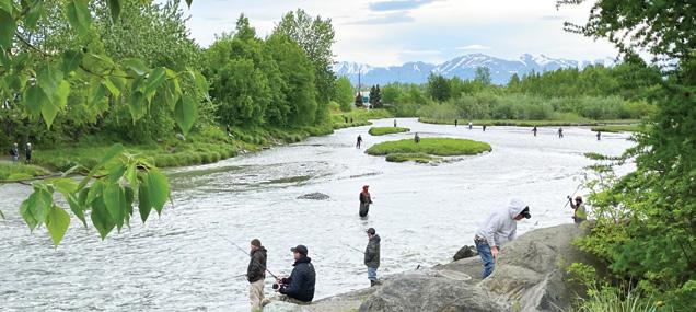
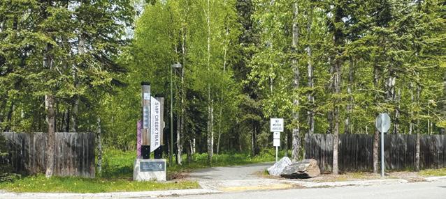
Ship Creek Trail runs along what was formerly a Dena’ina fish camp. It is now a transportation and light industrial center offering visitors a glimpse into what makes Anchorage a mighty shipping hub. The creek has retained its purpose, offering unique fishing and wildlife viewing opportunities along its riparian trail. It is common to see anglers pulling king salmon, from Alaska’s most productive sport fishery located in downtown Anchorage. The small boat launch, accessible via road, is the only public access to Cook Inlet in Anchorage. Ship Creek Trail is truly a unique experience where industry and wildlife live side by side.
Start at William Tyson Elementary School, 2801 Richmond Ave
0.2 mi to Reeve Blvd Underpass
1.6 mi to Bridge Crossing 1
2.0 mi to Bridge Crossing 2
2.3 mi to Spur to Ship Creek Overlook Bridge and Park
2.5 mi to Kings Landing
Alt A: 0.1 mi to AK Railroad, here the trail turns to dirt and follows the creek
Alt B: 0.4 mi Take the N C St bridge, walk to Small Boat Launch Rd, cross the creek again
0.5 mi to the Small Boat Launch and Grandma Olga Statue
Makes roughly 3.4 mi one way
If you’re interested in a side quest off the Ship Creek Trail the William Jack Hernandez Sport Fish Hatchery is a great one. The facility is open to the public Monday through Friday, 10:00am to 4:00pm. There is a visitor corridor for public viewing of hatchery activity and a foot path with views of Ship Creek. From early July through September, adult salmon can often be seen in this stretch of the creek.
941 N Reeve Blvd
By Lawrence D. Weiss
It gives me a good feeling to spend my final days surrounded by family, friends, and lovers. We are a great generation. We were all out at sea for five years. Most of us didn’t make it back. But look around... We are the lucky ones. We made it back, and we successfully spawned.
Now here we are in our last days, swimming to stay in one place, to stay with our community. We are elderly now. We’ve stopped eating but we have grown larger teeth. Ironic, isn’t it? In our final days we have large hooked noses and we’ve turned olive green. Some of us have fungi on the skin making it scaly and multi-colored. Our skin is starting to disintegrate and fall off.
Growing old is frightening and difficult, but we know it’s part of life. We share growing old with each other here as we swim just fast enough to match the current and stay in one place. We reminisce together and say our goodbyes together.
Look around. You can see that I have hundreds of companions. Look over there. That’s Frank. He’s getting weak. I don’t think he’s going to last out the day. And then the life-giving stream will become for him—and soon for all of us—the river
Styx. He will be carried away downstream where he will land in shallow water. Gulls and Eagles will dismantle him and he will be gone forever. This is how we end our lives.
But now I feel lucky to be surrounded by friends and family in my last days. We are all growing old together. That helps because we know we’re not alone. And we know that these terrible things that are happening to our bodies are just the other side of life – all those exciting years in the Pacific dodging predators and gorging ourselves on algae and tender little fish. And we have wonderful memories.
For the first time in my life and the only time in my life I spawned with a desirable, I would say erotic, female. Yes, that was incredibly exciting. And I wish we could have danced more than once. But that is our fate as humble chum salmon. We swam next to each other. Our hearts beat faster as the tempo raced forward – repeatedly nudging and bumping into each other – a furious nuzzling in the water. We danced in our passion. She dropped her eggs in our redd -- our love nest and the home of our children to be. I sprayed milt all over the eggs. We were exhausted but very happy.
I have only one regret. It is that we could only spawn once, because twice... twice might have made me feel at peace with everything happening to us now in the river Styx.
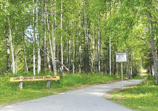
As you’d likely guess by its name, this trail winds along Chester Creek through a green belt that strings together neighborhoods. On the journey, you can visit several parks, some with small playgrounds, or in the case of Valley of the Moon Park, a large playground.
This trail also offers an extensive view of the always beautiful Margaret Eagan Sullivan Park and Westchester Lagoon, which attract shorebirds, songbirds, raptors, and everything in between. The lagoon is designated as an Important Bird Area (IBA), a global designation as critical bird habitat.
If you start or end your journey at University Lake Park, there are multiple trails that braid together, and it is easy to get turned around.
Start at Goose Lake Park, 2811 UAA Dr
0.3 mi to Tikishla Park (across Northern Lights Blvd)
0.8 mi to Davenport Fields
1.2 mi to Hillstrand Pond and Playground
2.0 mi to Eastchester Park & Woodside Park Playground
2.3 mi to a fork in the trail to the Stadiums & Arenas
2.7 mi to Charles W. Smith Memorial Park
3.0 mi to Valley of the Moon Park
3.4 mi to Westchester Disc Golf parking
3.7 mi to Margaret Eagan Sullivan Park
3.9 mi to the Coastal Trail
Makes roughly 3.9 mi one way
Disc Golf Course


Rollerskiing


Soccer
Stadium
CrossCountry Races Concerts Festivals


Inclusive Playground


Note: Not all trails are depicted; if you are unfamiliar with the park and don’t plan on staying on the Coastal Trail, it is highly recommended that you use a trail app for navigation. Make note of gate closure times.
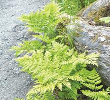
Kincaid is a park where people in Anchorage can experience the outdoors and natural beauty without traveling too far from home. The Park has something to offer everyone, whether you want to be active or still, participate in events, or enjoy quiet solitude. Kincaid is also a park with a history. It is a somewhat complicated history that involves the formation of the landscape, the story of native peoples, homesteading in the early days of Anchorage, the threat of Russian attack, and the many community partnerships that make the place a treasure trove of outdoor recreational opportunities. Kincaid Park is the Anchorage Park Foundation Park of the Year for 2024, and there is more to Kincaid Park than you might think.
See Pg 15
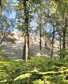
The landscape of Kincaid Park has varied and eye-catching topography. Cook Inlet surrounds the Park on three sides, with Turnagain Arm on the southern border and Knik Arm to the west. Kincaid offers vantage points from which Fire Island, Mt. Susitna, Mt. Denali, and Mt. Foraker can be viewed. In the distant past, near the end of the last ice age, the Knik and Matanuska glaciers created a river that carved out the hilly terrain and left deposits of silt and gravel. Many birch, cottonwood, and spruce trees grow on the hills, and Kincaid Park may even be home to some of the oldest trees in the city. However, the natural feature that stands out most may be the evershifting sand dunes.
Boating Fishing Archery Biathlon Range
Dog Training Area
Motocross Sand Dunes Indigenous Placenames
Chalet Rentals Picnic Shelter
Visit the Park-of-theYear website for further history, stories, Indigenous Placename Markers, event information, and more.
The Dena’ina have significant sites in Kincaid and Anchorage. One commemorates a battle between the Dena’ina and Ułchena raiders. This battle took place before white explorer contact in the 18th century when an Ułchena raiding party traveled to the area and kidnapped the wife of a Dena’ina chief’s son. Dena’ina warriors attacked the raiding party and successfully rescued the woman. The traditional name given to this site is “Ułchena bada Huch’iłyut,” which means “Where We Pulled up the Alutiiq Boats.” This site is one of thirtytwo locations in Anchorage and the Native Village of Eklutna to be recognized and given a cultural art installation as part of the Indigenous Place Names Project.
Kincaid Park is named for Ralph Goodwin and Delora Kincaid, homesteaders who moved to Anchorage in 1940. They were granted land in the Sand Lake area near Jewel Lake. At first, they worked the land, growing crops and raising livestock, but eventually, Ralph joined the local police force while Delora became civically active. The Kincaids founded Granite Products, Inc., which later became a partnership with another local family, Kincaid & King Construction. In 1948, the state bought portions of the Kincaid homestead to build the Ted Stevens International Airport. The Kincaids donated money, equipment, and time to build playgrounds and ball fields throughout the budding Municipality of Anchorage and were essential to bringing Little League Baseball to Anchorage. Ralph Goodwin Kincaid died in 1953 and his wife Delora Kincaid continued to be active with the company.
Before the sprawling Kincaid Park of today, there was an earlier park by the same name. In the late 1950s, the original Kincaid Park was located on land near the northeast side of Jewel Lake. The 27-acre tract was known as Kincaid Park at Jewel Lake. According to local newspapers of the time, this was a location where people picnicked, boated, and held community events. In the 1960s, the city wanted to rename this Kincaid Park to Jewel Lake Park. The Kincaid family opposed the change, so the city offered to have a different tract of land bear the name of Kincaid Park. In 1968, land the city had previously acquired from the U.S. military was chosen to be renamed Kincaid Park.
Before the U.S. military owned the land that is today known as Kincaid Park, it had been a part of the Chugach National Forest. The land was withdrawn in 1915 and became the Point Campbell Military Reservation. In 1959, during the Cold War, a Nike-Hercules surface-to-air missile unit was stationed there, and the location was known as Site Point. The soldiers used a radar system to monitor for incoming Soviet air strikes. When the Good Friday Earthquake hit in 1964, many of the missiles were knocked from their cradles and damaged, spilling propellant fuel and activating electronic components. The soldiers at the site labored for three days to clean up and safely secure the area. They were given a meritorious citation for preventing a potentially disastrous situation. The missile site was deactivated in 1979 and over time the land was passed on to the Municipality of Anchorage. Bunkers and other remnants of this period in the Park’s history can still be seen today.
Starting in 1973, Kincaid Park was intended to be a multi-use area. A land use permit was issued from the State of Alaska, and official development of cross-country ski trails near Little Campbell Lake began. Motocross races have occurred at the park site since at least 1975. Kincaid Park was officially created in 1978 and expanded in 1980 when the Municipality of Anchorage acquired the land from the Air Force through the Federal Land Surplus Act. In 1983, Kincaid Park came under the management of Anchorage’s Parks & Recreation department.

Proceeds go toward park+trail projects
Send a photo of yourself at the bench pictured and we’ll send you a prize. Please include your mailing address to receive a prize.
info@anchorageparkfoundation.org
Over the years, Kincaid Park has continued to be developed and improved. Landscape architects help to match new additions with the Park’s natural landscape and historical sites. The present-day chalet (Kincaid Outdoor Center) and several storage buildings were once Site Point military bunkers. The trapezoidal shape of the bunkers also inspired the look of four kiosks that were built in 1985. The parking lot covers most of the old rail system used for the missiles, but some parts of it remain visible. A brass plaque was displayed at the park to commemorate the soldiers’ hard work in the aftermath of the 1964 Good Friday Earthquake.
There are approximately 60 kilometers of winter cross-country ski trails throughout the park, Get Your Kincaid Park-of-the-Year Merch
Continued on next page
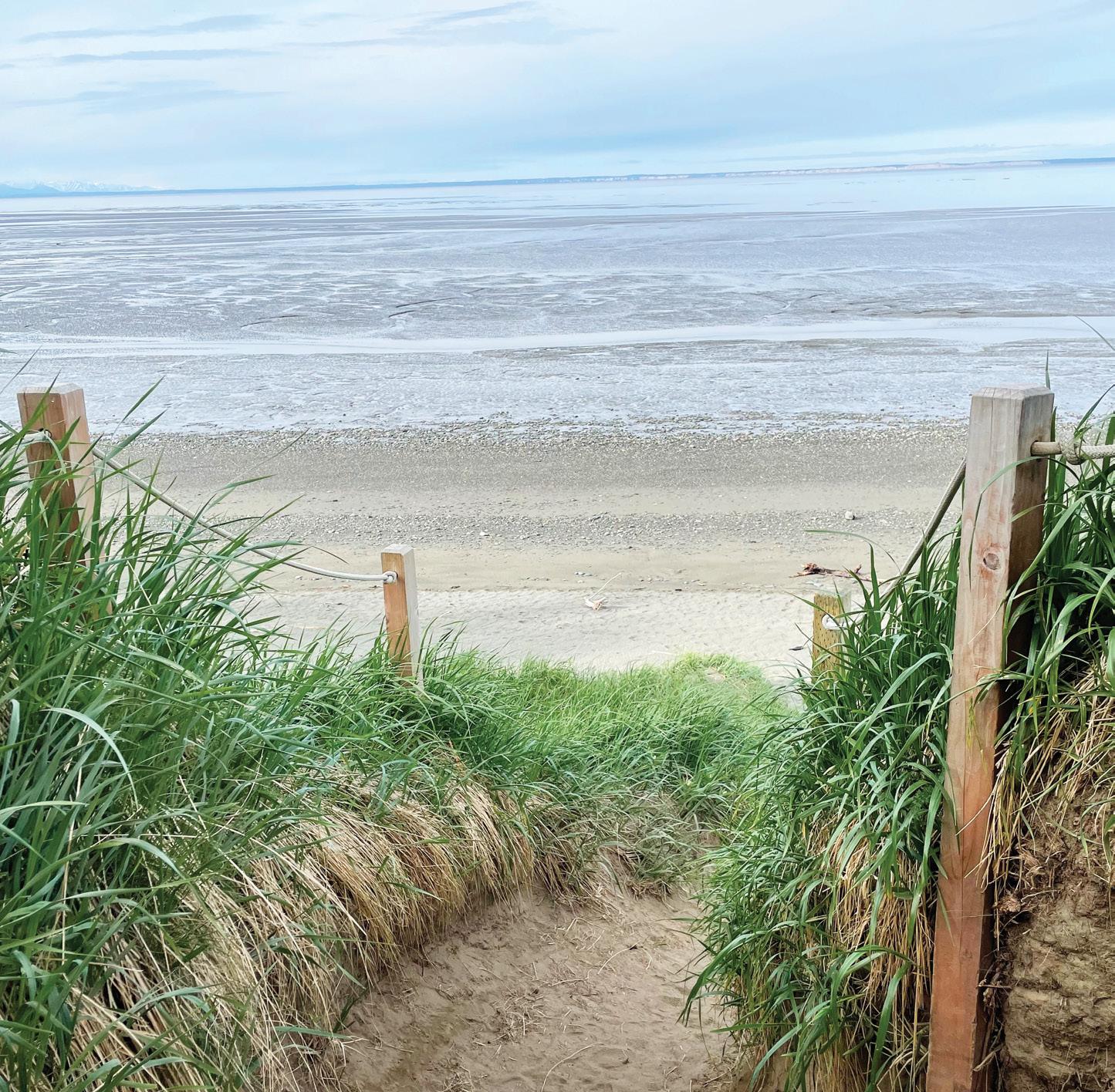
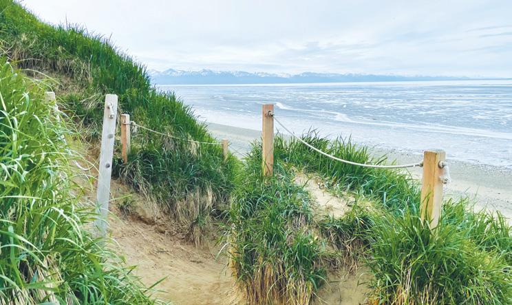
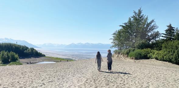
Visitors to Kincaid Park can access the beach via the Coastal Trail along the Moose Loop (see back cover). From the Kincaid Chalet, it is roughly a mile along a trail that winds down a rolling hill to a well-marked spur trail.
Start at Kincaid Park Chalet
1 mi to the Beach Trail Spur 250 ft to the beach
Makes roughly 1.2 mi one way
If you have time before a flight, drop off your luggage at the airport and catch a ride to spend time exploring the park.
which can also be hiked or biked in the summertime. The Tony Knowles Coastal Trail connects Kincaid to the rest of the city of Anchorage. Over the years, the park has created space for soccer fields, a disc golf course, a biathlon range, singletrack biking, fishing, boating, archery, dog training, and rollerskiing.
Kincaid Park has served as host to several major sporting events. As early as 1974, the park hosted the FIS cross country Ski championships. Other events have included the selection of the U.S. Olympic Teams for crosscountry skiing, Alaska Ski for Women, the NCAA National Cross-Country Skiing Championships, the 2001 Special Olympic World Games, and numerous local events. The park is lively, and there is always another event to look forward to just around the corner.
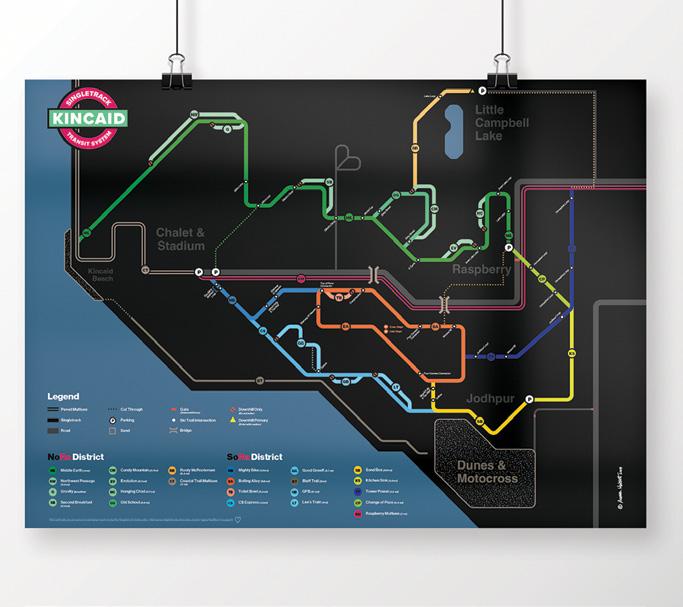
Featured Artist: Aurora Hablett
This unique poster reimagines the Kincaid singletrack trails in the style of classic metropolitan transit maps. This vibrant giclee print on archival paper showcases the trail systems in an easy-to-read format, serving both as a learning tool and art piece for Kincaid enthusiasts. Available in 24x18” or 16x12” sizes, these posters add a colorful touch to any space.
Over time, Kincaid has become woven into the fabric of Anchorage’s everyday life. People go there to stay healthy, relax, get closer to nature, and celebrate. Kincaid is the kind of park where people can think, look, explore, improve, be, and do. This is in no small part thanks to the many people who have helped take care of and develop the park’s landscape and recreation sites. As long as people continue to appreciate the park and all it has to offer, Kincaid will continue to be there for the people of Anchorage or anyone who needs a place to get away.
The Campbell Creek Trail is a favorite for nature lovers and foodie enthusiasts. Popular access points with parking are Chuck Albrecht Softball Fields, University Lake Park, Campbell Creek Park, Taku Lake Park, and multiple businesses along the way. This greenbelt artery is perfect for biking or walking, with plenty of dining, breweries, and local retail stops on the trail or only a short distance away. Additionally, the surrounding neighborhoods have multiple entry points that are convenient for locals and visitors to enjoy the beautiful creek and trail. Make a day of it and travel the Campbell Creek Trail while embarking on side quests to local businesses, restaurants, and breweries.
Start at Chuck Albrecht Softball Fields, 4781 Elmore Rd
to Campbell Creek Park, 2365 E 48th Ave
Fish Creek Trail connects residents and visitors with parks and businesses. It braids together neighborhood streets with local parks and greenways. This summer, we celebrate the completion of Ure Park Bridge, which connects trail travelers from McRae Rd to W Tudor Rd and the longer Fish Creek trail.
Start at Ure Park, 2108 Roosevelt Dr
0.2 mi to Red Bridge Park
0.4 mi to Northwood Park observation spur
0.7 mi to Underpass at Spenard Rd
1 mi along Turnagain Blvd to Fish Creek Park
1.3 mi to Woodland Park
1.6 mi to Barbara Street Park
Makes roughly 1.6 mi one way
The Dena’ina place name for Fish Creek, meaning, yellow water comes out
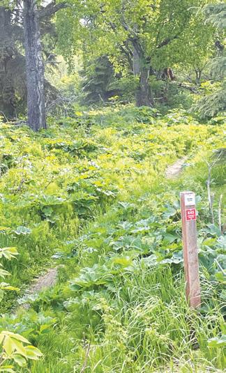
This neighbor-initiated trail project was completed in 2023. The trail starts in Chugach Foothills Park and offers a view of one of Anchorage’s most scenic wetland areas. The trail ends at the Alaska Botanical Gardens, making it a botanist’s dream walk.
Start at Chugach Foothills Park, 7975 Pioneer Dr
0.2 mi along Pioneer Dr to the intersection with Resurrection Dr
0.4 mi to Tikishla Street
0.5 mi to the trail at the end of Tikishla Street
1 mi to Bridge
1.4 mi to trail spur to Alaska Botanical Garden/Benny Benson School
Makes roughly 1.4 mi one way
The Mountains to Sea Experience links existing trails in a traverse from the new Hemlock Burn singletrack trail at the Glen Alps (Flattop) Trailhead down through the city, ending at the Small Boat Launch near the Port of Alaska. A video provides details for an experienced trail user to bike the 23 miles in a half day, including rest stops. This trail does not have signage that says Mountains to Sea, but you can find the route on trail apps like TrailForks and Ride with GPS navigation.
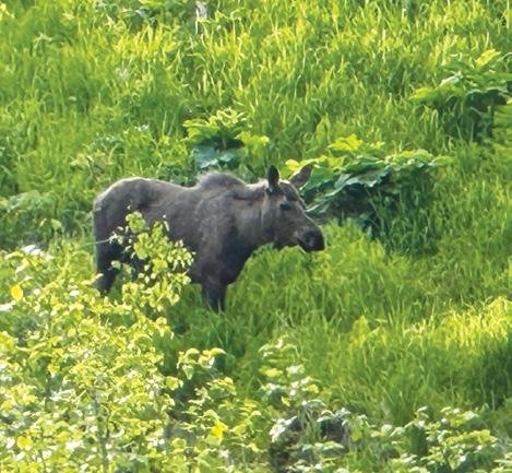
If you are looking for a walk with a gentle elevation gain and views of the mountains and the sea, try this loop from Prospect Heights. Plan on 90 minutes to 2 hours depending on your speed. Watch particularly for moose and cyclists. Take Golden Grass to South Fork Rim Trail. Take a left and follow to White Spruce Trail. Take a right on Powerline Trail which takes you back to the parking lot.
The Dena’ina place name for Glen Alps area meaning, crying ridge
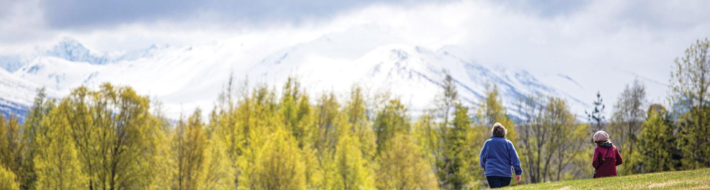
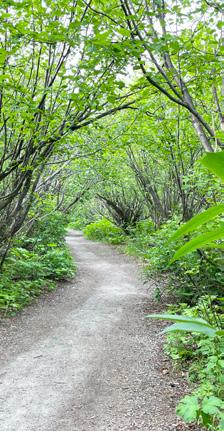
Getting out and walking on local trails is a fantastic way to immerse oneself in nature while reaping the health benefits of physical activity. Walking on local trails provides an opportunity to disconnect from the hustle and bustle of daily life and reconnect with your neighborhood and the natural world. It’s a great way to destress, clear one’s mind, and enjoy the beauty of the outdoors. Get out and about with friends and family, as a simple and accessible way to stay active.
Westchester Lagoon Nature Trail offers unique flora, fauna, and wetlands where creek flow slacks and water begins to pool in the Westchester reservoir. The 0.6-mile loop is perfect for a lunch break walk.
This is the ideal trail for taking a break in the UMED district.
Start at Goose Lake Park, 2811 UAA Dr
0.6 mi follow trail east past the Basketball Court, loop around the lake intersection with Alumni Drive
0.8 mi between UAA buildings to 2nd intersection with Alumni Drive.
1.0 mi along Alumni Dr to cross Providence Dr
1.2 mi along Wellness St to Health Dr on Cromer Trail
1.3 mi east to Sharon Gagnon Ln
1.4 mi to trail heading South
1.6 mi to intersection of E 40th Ave
1.7 mi to fork in the trail
2.0 mi between Providence buildings to Spirit Drive
2.2 mi to backside of UAA Student Union/Spine
2.3 mi to UAA Trail
2.4 mi to UAA Dr
2.9 mi to Goose Lake turn off / trail
3.0 mi to Goose Lake Parking
Makes a roughly 3 mi loop
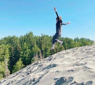
The Kincaid Sand Dunes offer a truly unique and breathtaking natural experience that is worth exploring. Located in a pristine coastal wilderness, the dunes provide a stunning backdrop for outdoor adventures. Whether you’re a nature enthusiast, a photographer, or simply seeking a peaceful retreat, the Kincaid Sand Dunes have something for everyone. With their undulating sand formations and panoramic views of the ocean, the dunes offer a sense of serenity and beauty that is hard to find elsewhere. So, if you’re looking for a one-of-a-kind outdoor excursion, come and experience the unspoiled beauty of the Kincaid Sand Dunes for yourself. 8200 Jodhpur St
By Rue Parker Kimball
A seagull chases an eagle with a salmon carcass — it’s filleted.
Submit your story or poem about Anchorage parks and trails for possible publication to info@anchorageparkfoundation.org


Anchorage has one of the best urban trail systems in the United States, with hundreds of miles of paved and multiuse trails connecting our city. Our four main multi-use trails—the Lanie Fleischer Chester Creek Trail, the Tony Knowles Coastal Trail, the Campbell Creek Trail, and the Ship Creek Trail—can be connected to each other to form a 32mile bike loop, an almost-complete urban greenway that is, when viewed on a map, in the shape of a moose!