5 minute read
History of Development in the Gingerbread Neighborhood
1860s Port-au-Prince sees economic and industrial growth.
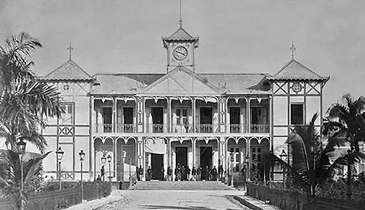
1881 Second National Palace [Image 01]. 1887 Villa Sam built 1880s-1920s
History of Development of the Gingerbread Neighborhoods.
While houses built in the Gingerbread style can be found throughout Port-au-Prince— as well as elsewhere in Haiti and the Caribbean—this report focuses on a concentration of these houses within Haiti’s capital, specifically in the historic neighborhoods of Bois Verna and Turgeau, continuing into Deprez, Pacot and Bas Peu de Choses. Then, as now, the geographical boundaries of these neighborhoods were not strictly delimited. Throughout this report, references to particular “neighborhoods” are intended to help readers achieve a general rather than absolute sense for the geography concerned. When used, the phrase “Gingerbread neighborhood” is synonymous with the Study Area, the zone within the boundaries described on page 19.
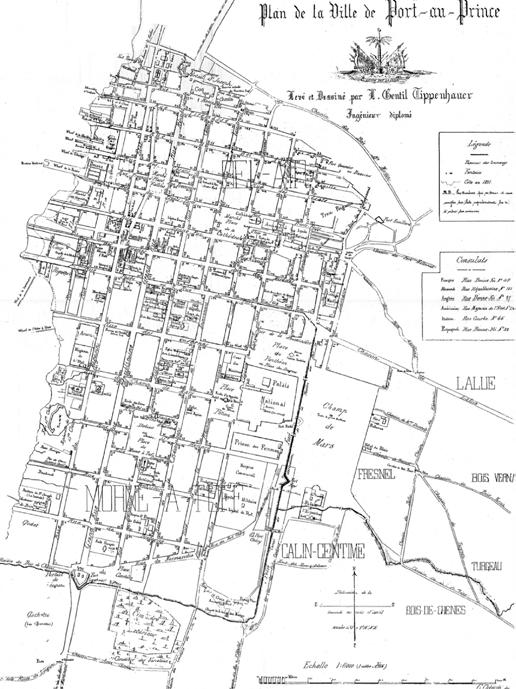
In the 1860s, Port-au-Prince experienced economic and industrial growth, serving as a center of trade due to its position as Haiti’s only port open to foreign exchange. As a result, a new bourgeoisie of wealthy traders, merchants, and educated professionals emerged. As the city’s population grew, necessitating its expansion, this new political, economic, and social elite sought to escape the density and chaos—as well as frequent fires—of Port-au-Prince’s downtown.[1] They migrated eastward, beyond the limits of the Champ-de-Mars, onto slopes of what historian Georges Corvington called the “green hillside,” creating new suburban neighborhoods surrounded by greenery and offering beautiful views.[2] By the turn of the century, the city had expanded to three times its colonial size, with a population of 70,000; approximately 8,000 houses were constructed to accommodate this expansion.[3] At this point, Turgeau and Bois Verna were recognized as the most prestigious neighborhoods.[4] Soon after, other similar neighborhoods like Deprez and Pacot were established. It was in these privileged communities,
(Today, Hotel Oloffson).
with a relatively short commute to downtown, that the Gingerbread houses were built. Gingerbread Era: National Style adopted for private residences.
Combining foreign influences with local traditions and adaptations, the eclectic, highly ornamental Gingerbread style of architecture was inspired by the construction of the second National Palace in 1881 and Villa Sam (now Hotel Oloffson) in 1887.[5] Serving as models for a national architecture, these buildings ushered in the Gingerbread era of 1880–1920, during which the style was adopted for the private residences of the wealthier classes inhabiting the aforementioned neighborhoods. Industrialization—first in Europe, then in Haiti—played a significant role in the spread of the Gingerbread style. Manuals circulated from Europe and North America allowed for the diffusion of international stylistic trends and a democratization of the construction process.[6] International exchange also came in the form of Haitian architects studying abroad in Paris, including Georges Baussan, Leon Mathon, and Eugene Maximilien.
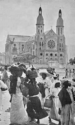
[7] These architects returned to apply their training and knowledge of European styles to private residences. Further, French artisans set up woodworking shops to train Haitian artisans in the decorative craft.[8] The invention of technologies for mass production meant that prefabricated ornamental and decorative elements could be ordered at lower costs.[9] The Gingerbread style became more accessible and spread to less wealthy citizens, and smaller, more modest Gingerbread houses for the middle and lower-middle classes began to appear. A 1925 ordinance banning wood construction due to its susceptibility to fire, along with the introduction of concrete, which was first used in the 1914 National Cathedral (Cathédrale Notre-Dame de L’Assomption), brought an end to the era of traditional Gingerbread colombage (timber and masonry) construction.[10] Concrete became the primary material for modern residences that were built to accommodate the rapidly growing population of Port-au-Prince. The city’s population grew to 120,000 as its area increased to five times its colonial size between 1925 and 1954.[11] One driving factor of this growth was the effort, undertaken during the
1900 City grows to 3x colonial size. “Plan de la Ville de Port-auPrince, 1897” [Image 02].
1901 Country roads become avenues.
1909 Introduction of automobiles.

First use of concrete: National Cathedral [Image 03].

1914 1925 Ban on wood construction due to fires and introduction of asphalt roads.
1925-1954 City grows to 5x colonial size.
1946 Revolution of 1946.
1950s-1960s Slum proliferation and urban decay. La “République” de Portau-Prince, Georges Anglade [Image 04]. American occupation that lasted from 1915 to 1934, to centralize previously regional markets, ports, budgets, and armies into the capital.[12] Parallel developments in transportation at this time, such as the transformation of country lanes into large avenues including today’s Avenue John Brown (formerly Chemin de Lalue) and Avenue Lamartinière (formerly Chemin du Bois-Verna) in 1901, the introduction of the automobile in 1909, of asphalt roads in 1925, facilitated the accessibility, growth, and densification of the old Gingerbread neighborhoods.[13] Following the Revolution of 1946, which overthrew the dictatorship of Elie Lescot, an emerging middle class led to the founding of newer neighborhoods consisting of more modest Gingerbread-style houses. These include Morne-à-Tuf and Bas Peu de Choses, located to the west of the earlier established Gingerbread neighborhoods.[14]
Centralization of political, economic, and military power in Port-au-Prince continued under the Duvalier presidencies from 1957 to 1971 (François Duvalier) and 1971 to 1986 (JeanClaude Duvalier).[15] Cities in outer provinces, with the closure of their maritime ports, faced degradation and depopulation, with a vast number of their inhabitants moving to the political and economic center of Port-au-Prince.[16] In addition, there was high migration from rural areas into Port-au-Prince, especially under Jean-Claude Duvalier, who focused foreign investment into industry and export-oriented agriculture. Privatization, falling incomes of small landowners, increases in food prices, and cuts in social spending pushed rural Haitians into cities, especially the capital, where they tried to earn a new living through industrial production.[17] These trends occurring at a national level directly affected the local cityscape of Port-au-Prince, reorganizing the social and architectural fabric of its neighborhoods.

Facing a massive population influx that resulted in intensified population growth and densification, Port-au-Prince in the 1950s and 1960s was marked as a period of urban decay and slum proliferation as much of the city’s open spaces were taken over by informal housing.[18] Historian Roland Devauges, writing in 1954, already recognized the relationship between altitude and social hierarchy in which the wealthiest residences were built on the highest ground. [19] Similarly, geographer Georges Anglade maps out the relationship between socioeconomic status and relative distance from the old colonial city.[20] Thus, the same trend that established the Gingerbread neighborhoods in the late nineteenth and early twentieth centuries was at play


