
4 minute read
Hiking


High Country Hiking
The High Country is a haven for outdoor enthusiasts, offering a seemingly endless supply of hotspots for hikers and campers of every level. Whether you’re seeking solitude in the tucked away corners of the map or a scenic stroll that’s suited for your whole family, you’ll find it here in the High Country. Here are just a few of our favorites.
Advertisement
ELK RIVER FALLS
As one of the High Country’s most popular waterfalls, you can expect a crowd on good weather days. But it’s worth it to catch a glimpse of the impressive 60-foot falls. The falls are a quarter-mile walk from the parking lot. From Boone, take Highway 105 South toward Banner Elk. Turn right onto Highway 184, and then turn left onto Highway 194. At the intersection of 19E, turn right. In 1.3 miles, make a sharp right onto SR 1303. Follow signs leading to the falls, making a left onto Elk River Rd.
HARPER CREEK FALLS
Harper Creek Falls is part of the Wilson Creek Gorge, which is a beautiful, secluded area. It may take some turning around to find it, but if you’re looking for something off the beaten path, you won’t be disappointed. Heading south on Highway 181, make a left onto Brown Mountain Beach Road.
Continue for 5 miles, passing the off-road area, and make a left on SR1328. Pass the commercial campground. The road will turn to gravel and there will be several parking places.
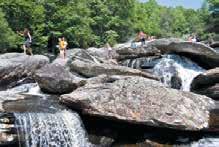
HEBRON ROCK COLONY
Hebron Rock Colony offers a beautiful, long slope of giant boulders, great for crawling, jumping and climbing. The river cascades down the rocks, creating numerous small waterfalls in between dozens of little swimming holes. To access the falls, do not park on Old Turnpike Road off of Old Shulls Mill Road. You will get towed. Park at Julian Price Memorial Park picnic area off of the Blue Ridge Parkway in between mileposts 296 and 297. To reach the popular summer hotspot, hike from the parking area about 1.5 miles on the Boone Fork Trail, where you will come out above the falls.

Gorge is as remote and pristine as it gets. Linville Falls can be viewed from a distance by hiking the moderate Erwin’s View Trail, which begins at the Visitor Center and is a 1.6-mile roundtrip. The Linville Gorge Trail and connecting trails within the gorge are recommended for highly experienced hikers only. These trails, often climbing and descending the V-shaped walls of the gorge, are very strenuous. To get to the Linville Gorge Visitor Center, take Highway 181 South to the Blue Ridge Parkway. Turn south on the Parkway and drive a few miles to the left turn for the Linville Falls parking area. The Linville Gorge Trail can be accessed at several locations along its western edge. Take US 221 South to Highway 183. Then turn left onto SR1238 (Kistler Memorial Highway). Trailheads are marked by parking areas on the left. Overnight camping in the Linville Gorge requires a permit Friday to Sunday, from May 1 to Oct. 31. For a permit, call the Grandfather District Ranger at 828652-4841.
PROFILE TRAIL – GRANDFATHER MOUNTAIN
Spectacular views and challenging terrain await at Grandfather Mountain. The Profile Trail to the top is 3 miles long and rises more than 2,000 feet in elevation. The first mile is fairly easy, but the trail becomes more challenging quickly after that. This trail does not requires a permit. To reach the Profile Trail entrance, take Highway 105 South from Boone for about 12 miles. Parking is on the left, about 5 miles past Foscoe.
STONE MOUNTAIN STATE PARK
With over 14,000 acres of protected land, Stone Mountain State Park is a nearly inexhaustible resource for hikers and campers. Trails vary from moderate to strenuous, and lead to several of the park’s landmarks – including Stone Mountain itself, a 600-foot granite dome overlooking the park. If you do not plan on camping overnight, be sure to set aside a full day. Stone Mountain State Park can be accessed from the Blue Ridge Parkway milepost 229. Take Highway 21 South to Roaring Gap. The park entrance located off of SR 1002, 7 miles south of Roaring Gap.
UPPER CREEK FALLS
Upper Creek Falls could be called nature’s playground. A swimming hole, complete with a rope swing, is located above the falls, and natural rock slides are found at several points below the falls. The waterfall itself is over 30 feet high, and continues for another 50 feet. The trail leading to the upper falls is less than 1 mile, but strenuous. Crowds are usually small, but sometimes loud. Take Highway 105 South from Boone. Turn left onto Highway 181 South. After crossing the Blue Ridge Parkway and passing signs for Table Rock, the parking lot for Upper Creek Falls is on the left.


