3 minute read
Land of Contrasts


The geology of Iceland
Iceland is a land of contrasts and diversity where beautifully colored lava, wide expanses of sand, and the power of its waterfalls all interplay. Only a short drive from Reykjavík one fi nds oneself in a vast wilderness where lava formations resemble modern sculpture, bubbling holes of mud with superheated water are found, glaciers fi ll valleys and geysers explode.
Geological Hot Spot
On a geological time scale, Iceland is a very young country. It is situated astride a divergent plate boundary, the Mid-Atlantic Ridge, and on top of a hotspot presumed to be fed by a deep mantle plume. At the plate boundary the two major plates, the Eurasia and North America Plates, move apart today with a velocity of about 19 mm/year. Th e divergence continues today and is accompanied by earthquakes, reactivation of old volcanoes and creation of new volcanoes. The best place in the world to study divergent plate boundaries is Þingvellir (Thingvellir), a short drive from Reykjavík where one can observe both faults and tension fissures related to the rifting and drifting of the North A merican and Eurasian plates away from each other.
Volcanic Eruptions Every Five Years
Iceland is one of the most active volcanic regions on earth, with eruption frequency of about 20 events per century. Iceland is home to more than 100 volcanoes and on average, a volcano erupts about every 5th year. Volcanoes define a wide spectrum of forms, ranging from a crack in the ground to the stately strato volcanoes like the Hekla volcano. Icelanders have learned to live with natural disasters and there is a risk that eruptions could take place at any time.
Laki’s great eruption in 1783 is the largest lava eruption known to the world in historical times. Enormous quantities of lava poured out and devastated immense areas of land. Poisonous gases and ashes from the eruption led to crop failure and livestock deaths.
In the famine that followed, one fifth of Iceland’s population died. Fortunately for Iceland, such cataclysmic events are rare.
A recent major eruption took place in 1973 when, without warning, a new volcano erupted on the eastern side of Heimaey in the Westman Islands.
In 1963, further south, accompanied by columns of fi re, clouds of ash and rumbles of thunder, a completely new island emerged from the sea. Th is island is called Surtsey after Surtur, the fi re giant from Nordic mythology.
Melting the Ice Age Away
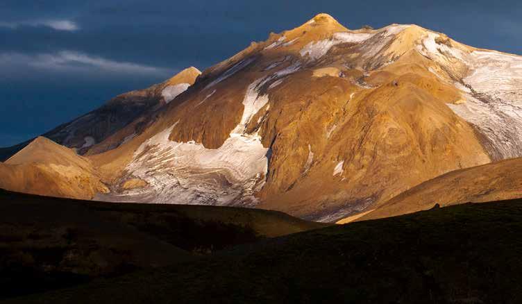
After the last Ice Age, the land had changed and great mountain ranges had grown from the sub-glacial eruptions. Composed mainly of crumbly rocks, like easily eroded tuff and rhyolite, they are the beautifully coloured mountains at Landmannalaugar, the mossclad cliff s of Þórsmörk and the grey ridges that transect the northern desert.
Where the eruptions were long enough, they broke through the ice and a hard cap of lava formed. After the ice melted, flattopped ‘table’ mountains appeared, of which Herðubreið is the most striking.
The older parts of Iceland, the east, north and north-west of the island were eroded during the Ice Ages and steepsided valleys and fjords were formed. Those mountains are made of many layers of basalts from eruptions that built the foundations of the island. Because of Iceland’s location, on the Mid-Atlantic Ridge, the island will be in the process of formation and transformation. Its old parts, the east and west carried away by the elements, while new parts are created by volcanic action.