An impact analysis for the National Guide for Wildland-Urban Interface Fires

Page 131

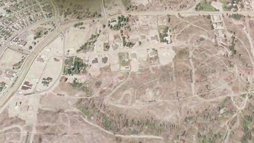
B.4 Penticton Indian Band Penticton Indian Band has a community immediately west of Penticton, BC, a medium-sized community (10,000 to 100,000 population) in the moderate hazard region (Figure 35). The community of 100–600 houses has two access routes, which is adequate. The community appears to have paved roads, like most of the houses in nearby Penticton listed on Zillow. Figure 35. Penticton Indian Band community near Penticton, BC

Shadows of utility poles indicate above-ground electricity, like the sample houses in nearby Penticton. Foliage is sparse and set back far enough from roads to suggest that power lines generally have 5 metres of clearance to vegetation, unlike most of the sample houses in Penticton. Images are not clear enough to check the presence of fire hydrants. There are no obvious water bodies from which to draft. Google Earth Street View does not reach the community, so the project team has no information about wall or roof cladding. Shadows suggest single-storey houses, but it is hard to tell. Assuming mostly single-storey homes, the average house is about 1,500 square feet, about two-thirds the average 2,200-square foot house in the sample of nearby Penticton houses listed on Zillow. Six of the ten sample houses (60%) in the Penticton Indian Band neighbourhood have ember-only exposure; the rest (40%) are moderate hazard, using the simplified method. Exposure levels are higher in the nearby sample Penticton houses listed on Zillow: 31% high hazard, 38% moderate, 8% low, and 23% ember-only.

115


Turn static files into dynamic content formats.

Create a flipbook

Articles inside

B.6 Knowledge gaps and limitations of these conclusions

3min
page 133

B.4 Penticton Indian Band

1min
page 131

B.3 Sagkeeng Anicinabe First Nation community

1min
page 130

Table 44: Summary of limitations and opportunities for future work

28min
pages 109-124

Table 43: Community costs to satisfy recommendations of the National WUI Guide

9min
pages 105-108

Table 42: Allocation of costs and benefits among stakeholder groups

5min
pages 102-104

Table 41: Long-term national benefits and costs of the National WUI Guide

1min
page 101

Table 39: Total household costs for community-level compliance

1min
page 99

Table 37: New design benefits, costs, and benefit-cost ratios for satisfying the National WUI Guide

12min
pages 91-95

Table 38: Municipal and utility costs for a sample community

8min
pages 96-98

Table 30: Vulnerability (i.e., the response function) by equation 5

2min
page 86

Table 20: Cost options to evaluate for each archetype

1min
page 75

Table 19: Unit costs to satisfy recommendations of the National WUI Guide

2min
page 74

Table 17: Vinyl cladding fire spread ratings for some leading manufacturers and common products

13min
pages 68-72

Table 18: Initial clearing and maintenance costs for priority zones

2min
page 73

2.12 Community costs for planning and resources

5min
pages 36-37

3.6 Community costs for WUI guide Chapters 4 and 5

11min
pages 48-52

Table 2: Sample house data fields

6min
pages 43-45

2.13 Cultural and other intangible non-monetary issues

2min
page 38

3.2 Select archetypes

1min
page 42

2.8 Additional living expenses and business interruption losses

3min
page 33

2.6 WUI fire vulnerability models

2min
page 31

1.3 Organization of the report

1min
page 19

2.1.4 Relevant Evidence from the 2011 Flat Top Complex Wildfire

3min
pages 21-22

2.7 Deaths, non-fatal injuries, and post-traumatic stress disorder

2min
page 32

2.1.6 Relevant Evidence from Recent California WUI Fires

7min
pages 24-26

2.3 Retrofit and new design costs, benefits, and benefit-cost analysis

2min
page 28

Summary of key findings

2min
page 17

2.2 WUI guides, standards, and model codes

2min
page 27
Issuu converts static files into: digital portfolios, online yearbooks, online catalogs, digital photo albums and more. Sign up and create your flipbook.