29 minute read
Urban Core experience


1.1 KEEP THE URBAN CORE CLEAN AND SAFE FOR ALL TO ENJOY
1.1a) Enhance the comfort and appeal of the urban core’s public realm with expanded streetscaping efforts
Advertisement
Background Getting the fundamentals right on safety, aesthetics, and beautification is an essential first step in the creation of a flagship downtown experience. The look and feel of a downtown impacts the first impression of visitors, the experience of customers, and the wellbeing of residents and employees, and a place that is well maintained, well lit, and well populated with people coming and going feels safe and welcoming, sending the message that you have arrived somewhere you are supposed to be. While many have noted that public safety is a priority for the Urban Core, data and discussions with Macon-Bibb Police underscore that the Urban Core, and downtown in particular, are safe places to be. Improvements that generate additional activity and enhance the comfort and appeal of the public realm will draw more people, which in turn will combat perceptions and misconceptions about crime and safety.
The Urban Core enjoys the good bones of its beautiful buildings and existing urban tree canopy, which form the backdrop of the public realm. The MAP movement is already tackling the city’s streets, for example through the new planters on Cherry Street. Now onto the next steps:
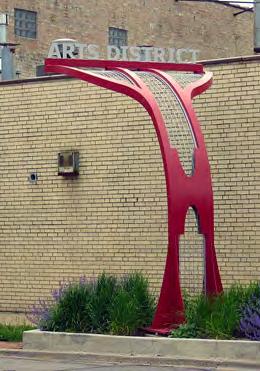
Key ideas MAP beautification projects, adopt-a-planter program, lighting on buildings, street trees, and trails; public art on alleys and rear walls, data tracking of crime specific to the Urban Core
Action MAP beautification project With leadership and funding from local partners, organize a MAP beautification project to keep the public realm lush, clean, and maintained.
Adopt-a-planter While DIY programs such as an adopt-a-planter program can invite local businesses, organizations, groups, and families to participate in greening downtown, a dedicated management plan and staff will be necessary for achieving the desired standard for a cleaner and more beautiful downtown. This staff will work with local businesses and volunteer groups to cultivate the existing tree canopy, maintain flower beds and planters, and clear litter from the sidewalks. In most successful downtowns, a business improvement district (locally proposed as a CID) serves this function effectively by dedicating staff to address these opportunities.
HOW IT’S DONE ELSEWHERE:
NKCDC’s Corridor Cleaning Program, Philadelphia, PA
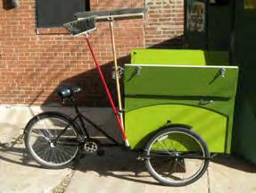
With a tight budget, this commercial corridor focused on keeping the corridor clean with a single worker, whom they are able to pay a living wage ($13/hr) with benefits and sick time. Provided with a custom greenpainted tricycle, it houses brooms, trash bags and cleaning chemicals, this worker is dedicated to keeping the commercial corridor clean. He is now the sole expenditure of the program with the exception of bike maintenance and cleaning products, keeping the budget for street cleaning to a minimum.
Adopt-a-planter program, Chico, CA
The Downtown Chico Business Association has run the Adopta-Planter program since 1998. Families, community groups, and businesses have adopted 43 planters to assist with maintenance. Other cities with similar programs include: Jordan, Minnesota; Gillette, Wyoming; and Sterling, Illinois.
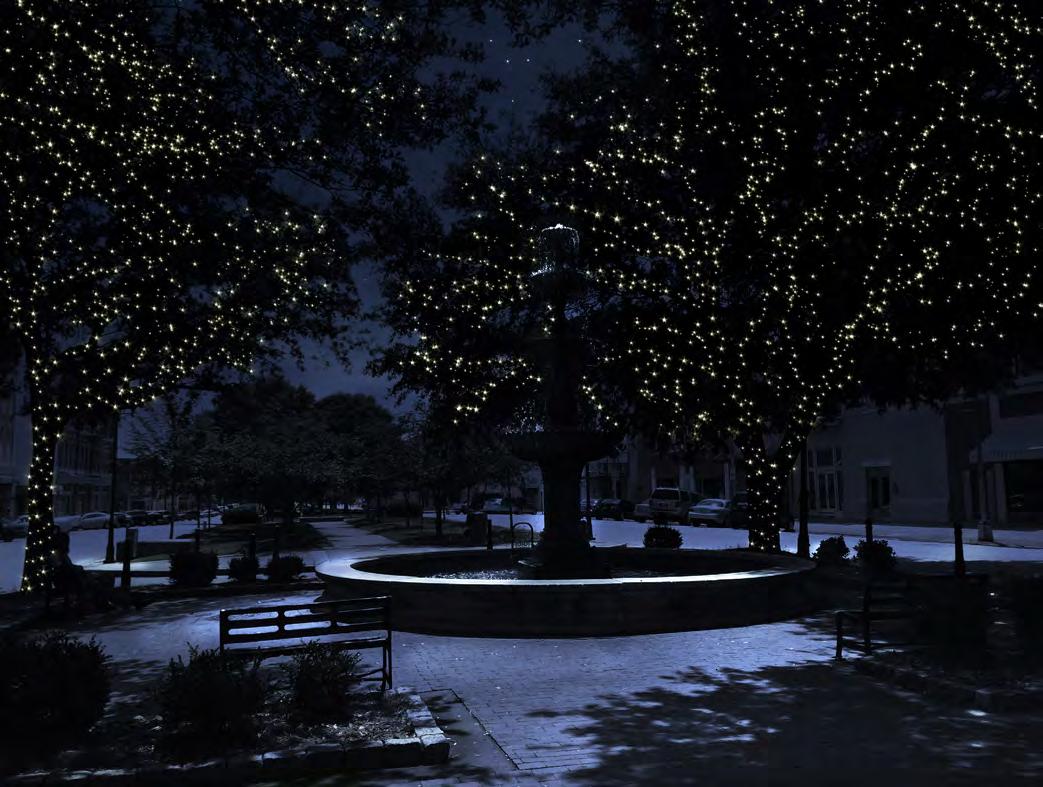
Lighting on street trees, buildings, and along the trails Start a “city of lights” campaign. This could also happen through sponsorships by downtown businesses and other interested groups. Sponsorships could be tiered by scale and cost: silver (tree), gold (building), and platinum (trail). Small plaques could adorn the trees, lampposts, and building facades to show appreciation. Test these ideas first and expand later. For example, start the lighting of street trees on Cherry Street from Terminal Station to Cotton Avenue and coordinate a group of five building owners to volunteer their façades for creative lighting.
HOW IT’S DONE ELSEWHERE: Wall Therapy, Rochester, NY
“We are intervening visually to address a fundamental collective need of our citizenry, the need for inspiration.” The wall therapy project started with a weeklong festival in which 11 street artists from across the globe painted 16 walls throughout the city. By 2013, the number of murals had grown to 48. The project was sponsored by Dr. Ian Wilson, a local radiologist.
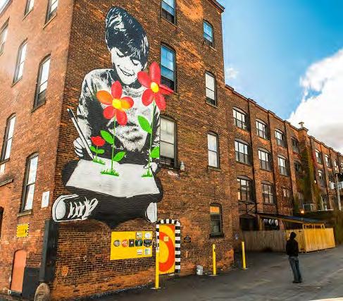
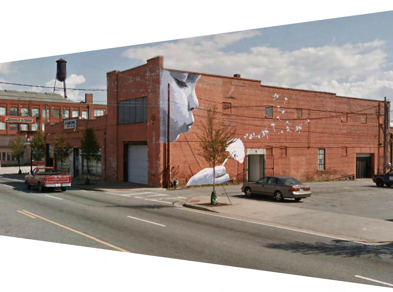
Public art Work with the Macon Arts Alliance and put out an RFP (request for proposals) to local and regional artists to gauge interest and capacity for adorning alleys and rear walls with mural art. Pursue funding from the Artworks Program by the National Endowment for the Arts. Data tracking of crime specific to the Urban Core Finally, collect and track crime data specific to the Urban Core to measure success. Quarterly reports will help to bring more information to the conversation around safety in the Urban Core and highlight the role MAP is taking in addressing the issue. wall-therapy.com
1.1b) Introduce additional trash, recycling, and maintenance efforts
Background: The collection of recycling is currently limited in the Urban Core. Weekly collection of newspapers and magazines only (no cardboard) occurs in the entire City on the same day as regular trash pickup. Single-stream collection occurs bi-weekly in four neighborhoods in Macon: Intown, Shirley Hills, Vineville, and Wimbish Road, however these do not cover all neighborhoods within the Urban Core. In the single stream program, residents are provided a 65-gallon blue roll-off cart to collect glass bottles, clean paper, mail, newspaper, magazines, catalogs, phone books, paperback books, wrapping paper (no foil or ribbons), plastic bottles and jugs (no caps or lids), clean plastic dairy jugs (yogurt, margarine, etc.), and aluminum, steel, and tin-plated cans. Paper and cardboard can be dropped off at local fire stations; the only location in the Urban Core is Fire Department Station 1 on 195 Coliseum Drive. In terms of public recycling amenities, the Urban Core has no public recycling bins on its streets.
To address these limitations and other challenges, the Macon-Bibb County Materials and Solid Waste Management Plan has set forth two main goals: “1) Reduce by 25 percent the total amount disposed (per person) in MSW [municipal solid waste] landfills by 2025, and 2) divert 30 percent of the materials collected from residents through recycling and composting by 2025.” The first strategy in order to achieve these goals is to develop a “Recovered Materials Processing Facility” (RMPF) that will process and market recyclables in the region.
The plan then offers several strategies that will impact the Urban Core once this facility opens. Firstly, it aims to collect single-stream recyclables from all residents in the county. Participation will be required of all residents, and an extensive education and outreach plan will accompany the increase in collection. Drop-off centers at fire stations will continue to accept recyclables, and additional, more comprehensive recycling drives will take place in order to collect items not accepted curbside, such as electronics. Yard trimmings will also be collected separately and taken to a proposed construction and demolition debris management facility.
The Solid Waste Department also aims to work with the Urban Development Authority to offer single-stream recycling in areas in the Central Business District with high volumes of pedestrian traffic. It will work with Macon-Bibb County Parks and Beautification to offer single-stream recycling in county parks as well. Furthermore, through partnerships the department will collect recyclables at special events, such as the Cherry Blossom Festival.
An additional strategy is to streamline solid waste and recyclable collection system in the Central Business District. The Solid Waste
Department will provide containers and organize collection. In addition, collection of recyclables will take place in the Central Business District once the RMPF opens. The plan outlines a “model recycling program” for businesses and multi-family properties in the Central Business District. All downtown properties will have to pay for recycling containers regardless of whether they use them. They will be charged for garbage disposal and therefore incentivized to recycle. This program will be implemented with the Urban Development Authority and include technical assistance and promotional materials. Macon-Bibb County will also assess whether commercial and institutional organizations should manage organic materials on-site in anaerobic digesters as part of helping the streamlining process.
The plan also details significant education and outreach efforts, including ongoing collaboration with the Keep Macon-Bibb Beautiful Commission, Internet and social media usage, presentations, print materials, educational school programs, an education and training center, and technical assistance for businesses and institutions.
Key ideas: comprehensive municipal waste removal & recycling strategies, trash & recycling bin audit
Action: Comprehensive municipal waste removal & recycling strategies Press forward with implementation of the comprehensive municipal waste removal and recycling strategies in the Macon-Bibb County Materials and Solid Waste Management Plan. By integrating singlestream recycling bins within the public realm, recycling will become more convenient, and therefore more of a habit for members of the community, at home, at work, and at play in the Urban Core.
Trash & recycling bin audit To locate new bins where they are most needed, undertake an audit of street trash and recycling bins in the Urban Core to understand where they exist and where they are lacking.
Goal:
1.2 TRANSFORM MACON’S SIDEWALKS AND PUBLIC SPACES AS THE CENTER STAGE FOR COMMUNITY LIFE
1.2a) Improve use of underutilized spaces, including alleys, medians, and vacant storefronts
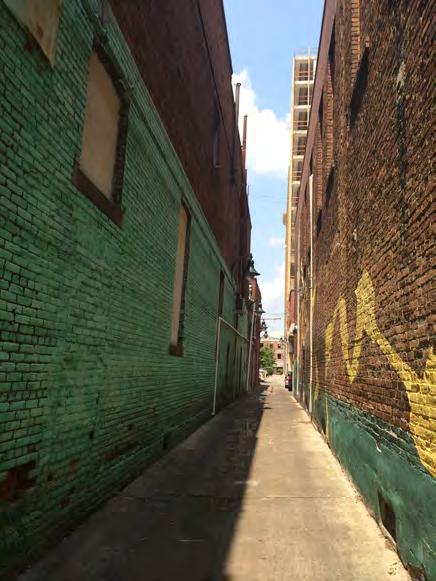
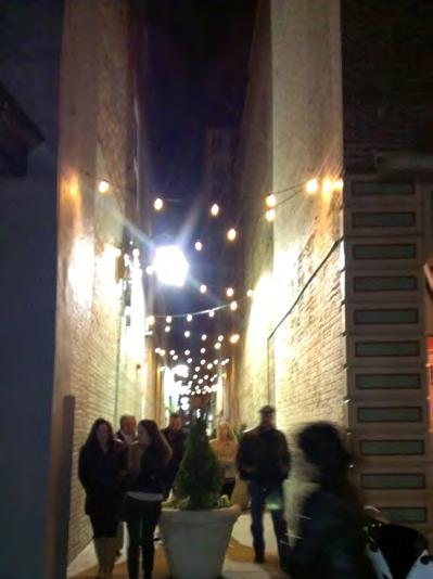
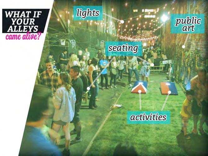
Background: Alleys, medians, and vacant storefronts are underutilized spaces in the Urban Core. Participants explained during the public outreach process that they liked to use the alleys as walkways, yet these unique, small-scale spaces could be opportunities for creative expression and relaxation as well. The underutilization of the medians stems from their separation from activity on sidewalks by fast-moving traffic and rows of parked cars. Some also have limited landscaping and as such are uninviting during hotter months. Vacant storefronts are valuable opportunities to close gaps along the streetscape in the Urban Core.
Key ideas: Destination alleys, movable furniture purchasing plan, friends of the medians, storefront activation
Actions: Destination alleys Create destination alleys by restricting traffic and adding decorative lights and seating, among other possibilities. Alleys too narrow for passage or programming are good opportunities for stormwater management through permeable pavers. Start with three to four of the 10-foot wide alleys, which run parallel to 2nd and 3rd streets, and opt for those that are next to existing active commercial uses (see map). This should be a joint effort between the CID and Public Works Department.
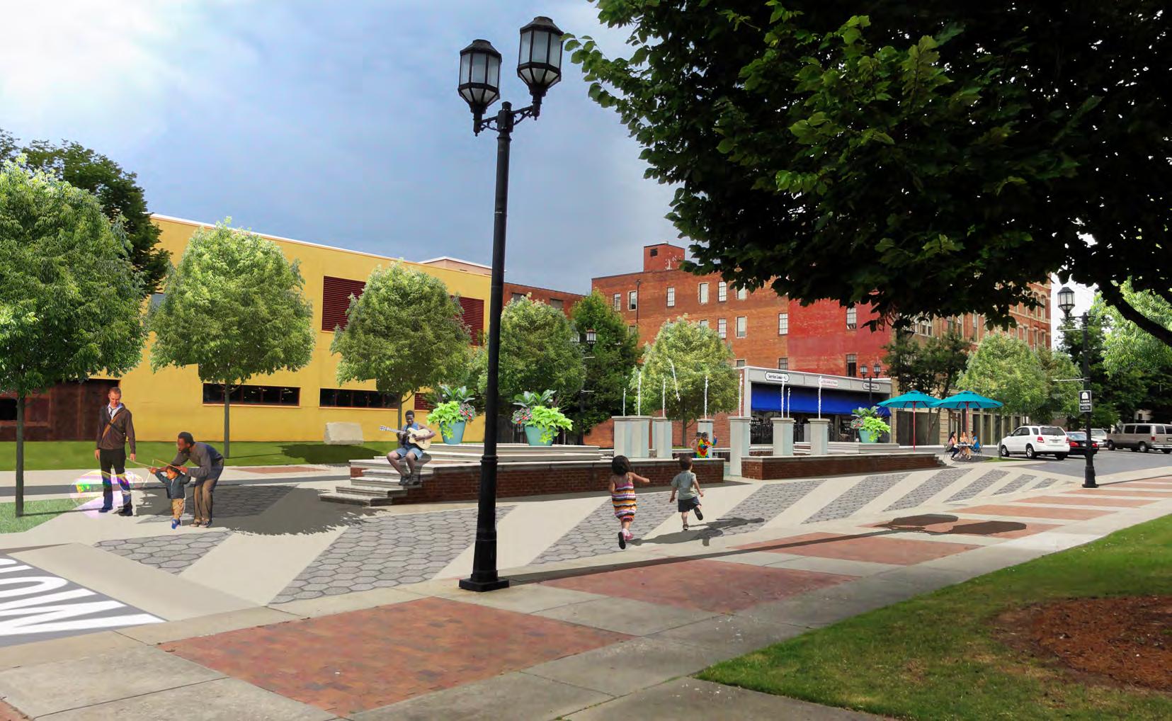
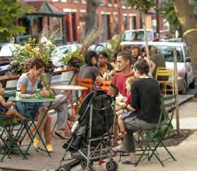
Movable furniture purchasing plan Established and temporary public spaces across the country are reinventing themselves by inviting visitors to customize their own experiences through the use of movable furniture. The CID should develop a movable furniture purchasing plan to coordinate the quantity and type of tables and chairs, the best vendor, and the appropriate time. These tables, chairs, lounge chairs, and shade umbrellas should be tested and deployed throughout the Core, in existing plazas and medians, along destination alleys, and where opportunities exist to improve downtown’s wide sidewalks. One such place is at the intersection of 3rd and Cherry, defined by many as the heart of downtown. Here, the linear placement of benches in front of The Dempsey is not conducive to conversation and visiting, failing to adequately serve the Dempsey residents and preventing others in the Urban Core from feeling welcome in this shared space. This key intersection should be redesigned to encourage use of the sidewalk by all downtown residents and visitors.

Friends of the Medians Launch a “Friends of the Medians” group to focus on infusing life and color into Macon’s historic medians. Flower gardens, sandboxes in the shade for tots, and picnic areas populated with movable furniture (see above) near cafés and restaurants can all breathe new life into these mid-road spaces and drive foot traffic to nearby businesses. Partner with Bibb County Master Gardener Program (UGA Cooperative Extension), Macon-Bibb Parks & Rec, Macon Civic Spaces, Main Street Macon, and adjacent businesses.
Storefront Activation Activate vacant storefronts with pop-up installations. Work with Main Street Macon and the Macon Arts Alliance to solicit installations from local artists and others in Central Georgia. Pair the debut of the installations with other evening events, such as First Friday. Focus on some key streets, in particular along 2nd Street and Cherry Street.

1.2b) Improve and expand open spaces to create a central gathering space downtown and in each neighborhood
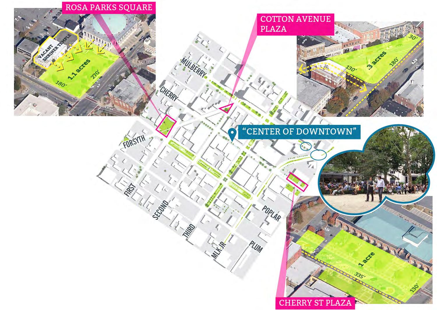
Background: Parts of the Urban Core have wonderful parks that serve as centers of the community; think of Tattnall Square Park and Washington Park in College Hill. But downtown needs a central gathering space, as do some of the neighborhoods in the Urban Core, including Pleasant Hill and East Macon’s Main Street neighborhood. As demonstrated by College Hill’s success, to help improve the Urban Core experience, residents should make the most of their public spaces, activating them as destinations for many types of users. The Urban Core has five distinct opportunities, each with its own identity:
With its central and picturesque location, proximity to active retail, local government and institutions, and ample size, Rosa Parks Square is ideally suited to serve as downtown’s central gathering space. Currently underutilized and often people-free, the Square’s many assets will help transform it into a vibrant space with opportunity for active and passive uses during both daytime and evening hours. In its current state, it has very little connection to nearby uses, and no ‘active edges’ making it feel isolated and disconnected.
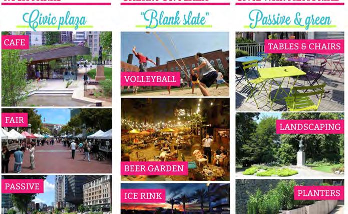
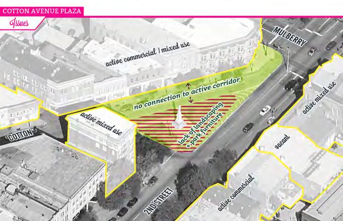
Improvements to the Cotton Avenue Plaza at Second Street will complement to those at Rosa Parks Square and offer an additional opportunity for passive recreation and relaxation. Currently, the triangular green space is small, relatively unused save for a Civil War statue, and surrounded by a mix of active and vacant storefronts.
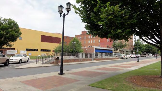
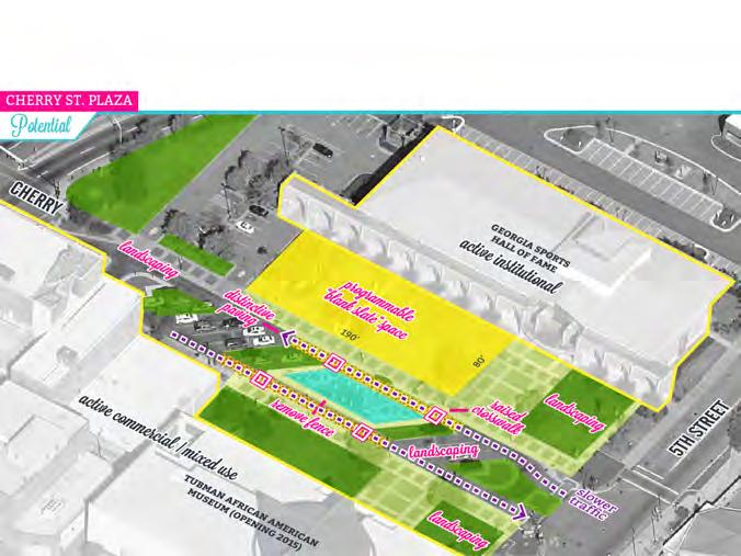
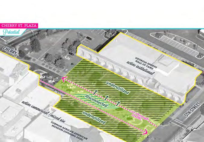
In contrast, Cherry Street Plaza will become the “blank slate” for Macon, offering a large, flat, open space for a range of active uses. Currently, it is really a parking lot with a small plaza inside. There is an opportunity to activate this space, integrate the fountain, and add greenery. More of a park, less of a parking lot!
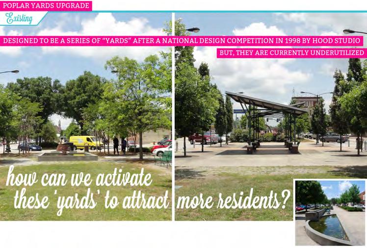
The Poplar Street median, known as the Poplar Street Yards, was redesigned to be a series of ‘backyards’ after a National Competition in 1998 by Hood Studio. When it was first installed, as seen in the photo to the right, the park had a series of rooms, forming many different kinds of hang out space. 15 years later, many of the gravel paths have disappeared due to lack of maintenance, and the fountains are off leaving pools of water that collect trash and have an unpleasant smell. A better management plan and some new programing would encourage more residents to take advantage of this valuable open space and breathe new life into this underutilized park at the heart of redevelopment activity. And last but not least, there is need and opportunity to upgrade and/or create neighborhood parks to ensure that all Urban Core residents have improved access to community green space within their neighborhoods.
Key ideas: Rosa Parks Square, Cotton Avenue Plaza, Cherry Street Plaza, Poplar Yards, Neighborhood Parks
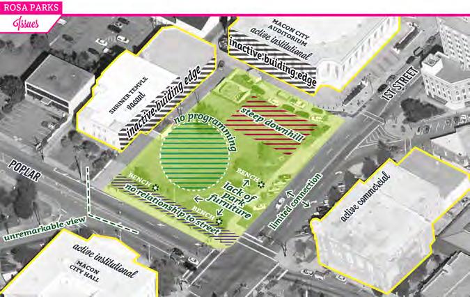
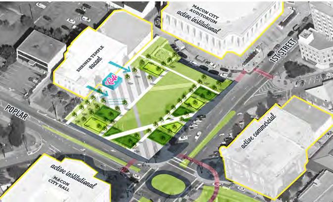
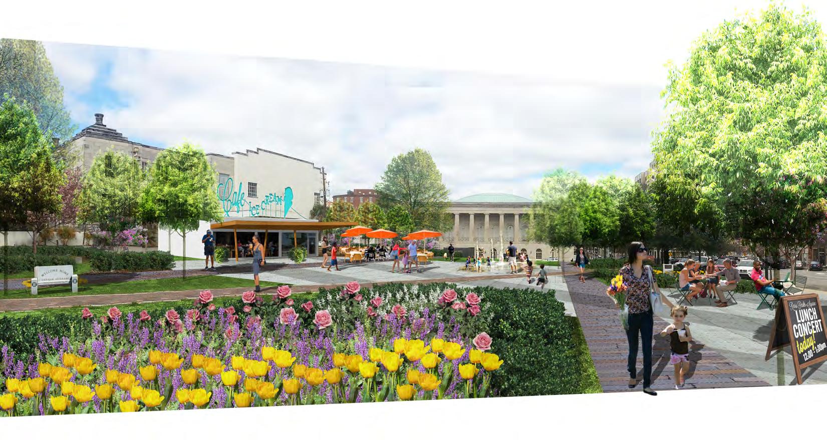
Actions: Rosa Parks Square Augment the design of Rosa Parks Square. To accommodate both passive (a quiet, relaxing, park-like setting) and active (concerts, yoga, and other event-driven programming) uses, this remodel includes design features to suit both of those programs. New garden rooms enclose the perimeter, each providing greenery and a structure for passive recreational uses. These rooms should be situated to frame the view of the City Auditorium, so when standing on the steps of City Hall looking into the park the magnificent architecture remains in clear view. To activate the central space, incorporate a park café or ice cream shop oriented along the former Shriner Temple.* This café will not only help draw users into the park, it will help generate income for the maintenance of the park and gardens. Transforming some of the open lawn into an open plaza space in front of the café will allow for flexible seating and gathering configurations. By providing dedicated space for programming, the remainder of the park’s landscaping will be better protected. The sloped portion of the park should be re-graded to create a flat lawn for passive use and better welcome visitors to the Auditorium. This type of space requires an inviting main entrance to draw people in, and the corner at First Street and Poplar Street can meet that need. The existing statues, monuments, and plantings can all be incorporated into this redesign, particularly in the garden rooms. Rosa Parks Square can thus remain an important memorial space while also serving as a beloved and often-frequented gathering place for all visitors and residents in Macon’s Urban Core.
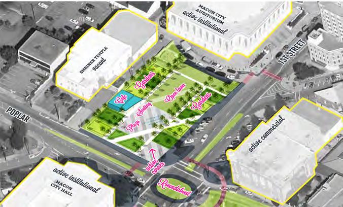
*Note: The Shriner Temple, an auditorium built in 1929, is located on the northwest side of the park and is currently vacant. The proposed café could be located in the Temple if it is redeveloped in the near future. In this case, the developer should ensure that the main frontage of the café opens onto the park to activate that edge. In this case, the café design could utilize a new opening in the façade, or occupy a retrofit to the existing carport. Ideally, this new development would fold the existing driveway into the new open space, so that car traffic does not conflict with pedestrians and park users, and so that the café becomes integrated with the park. To test the idea, the driveway could be used in the short term as an area for food trucks. These food trucks would serve the same function as a café but on a temporary basis.

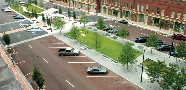
Cotton Avenue Plaza Improve upon the Cotton Avenue Plaza triangle, making it a little bigger by closing Cotton Avenue between Mulberry Street Lane and Mulberry Street and extending the triangle to the curbside. Introduce tables and chairs for passive use and lunchtime dining, and add landscaping to provide shade and greening. Automobile circulation would be changed slightly; motorists traveling toward Second Street on Cotton would instead make a right onto Mulberry Street Lane at the plaza space, before turning on Second Street. This configuration is safer for pedestrians, and the larger plaza will provide a beautiful capstone to one of Macon’s most historic streets. Research has shown that in cities both smaller and larger than Macon, this type of public investment attracts more customers who, in turn, support local businesses.


Cherry Street Plaza Formalize the lawn in front of the Georgia Sports Hall of Fame as a programmable blank space in Cherry Street Plaza. Ideally, improvements should incorporate a new surface material (brick) on the western half of the park. In the first year, however, test run various programs in the space first before incorporating new paving. Start off with a beer garden and beach volleyball for the spring and summer months, for example. Transition the space for cooler weather with an ice rink during the holiday season. After this trial year, evaluate whether formal paving would facilitate better use of the space. To better connect the central fountain area to the rest of the park, create a long raised crosswalks on both sides of the fountain to visually link the fountain with adjacent lawns and landscaping and slow oncoming traffic. The current fencing is unwelcoming and should be removed. Remove the parking spaces that are adjacent to the fountain to add some much needed greening in the middle of the street and provide some shade for parents watching children play in the fountain. Plant street trees along the edges of the park. Strategy 4.3a includes recommendations for additional transit connections at Terminal Station, which would also bring more people to and through Cherry Street Plaza.
Upgrade Neighborhood Parks to serve as focal points and vibrant public spaces for neighbors. There are key opportunities in each community.
• Reclaim excess asphalt at the three-way intersection of Cherry, Magnolia, and Spring streets adjacent to Bernd Park, extending the green space such that the Spring Street block face and sidewalk aligns with the blocks above Cherry and below Magnolia. Upgrade the park as a neighborhood park with new floral plantings, shaded seating, and elements that give the park some personality, drawing neighbors in rather than letting them continue to pass by this passive space. Take cues from the work projects accomplished by neighbors through the Friends of Tattnall Square Park.
• Support continued investments in Tattnall Square. The Friends of Tattnall Square have done a remarkable job to organize park improvements and leverage partnerships with Mercer University and the City. What was an overlooked park is now an important destination for College Hill, Beall’s Hill and the region. Support and celebrate continued improvements and programming.
• Improve the Booker T. Washington Recreation Center. This resource has long been an important amenity for Pleasant Hill. To maximize its potential, improvements are necessary to ensure the facility and programming fully engage and support local youth and families.
• Create new open spaces in the Main Street neighborhood. There are no public parks in this community, and strong boundaries such as high-traffic roads make accessing nearby parks difficult. MAP identifies two opportunities for green space: 1) As a part of the Clinton Street improvements to enhance access to the Indian Mounds, establish a “stormwater park” between Clinton and Schell to serve as a beautiful and passive entrance to the community; and 2) Repurpose the lawn in front of the Family Investment Center as an active orchard maintened organized by local youth and families.
HOW IT’S DONE ELSEWHERE:
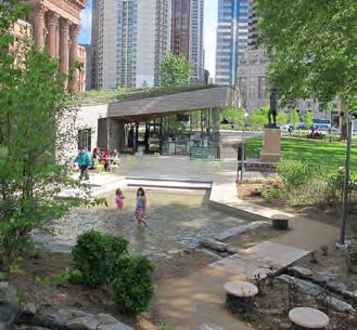
Sister Cities Park, Philadelphia, PA.
Sister Cities Park covers 1.3 acres in Center City Philadelphia and features a café, children’s discovery garden, imagination playground, plaza, and fountain. Despite its location next to a busy roundabout and high rises, it offers an oasis that is open and intimate at the same time. This 5.1 million dollar park was made possible with help from the Knight Foundation.
www.ccdparks.org/sister-cities-park
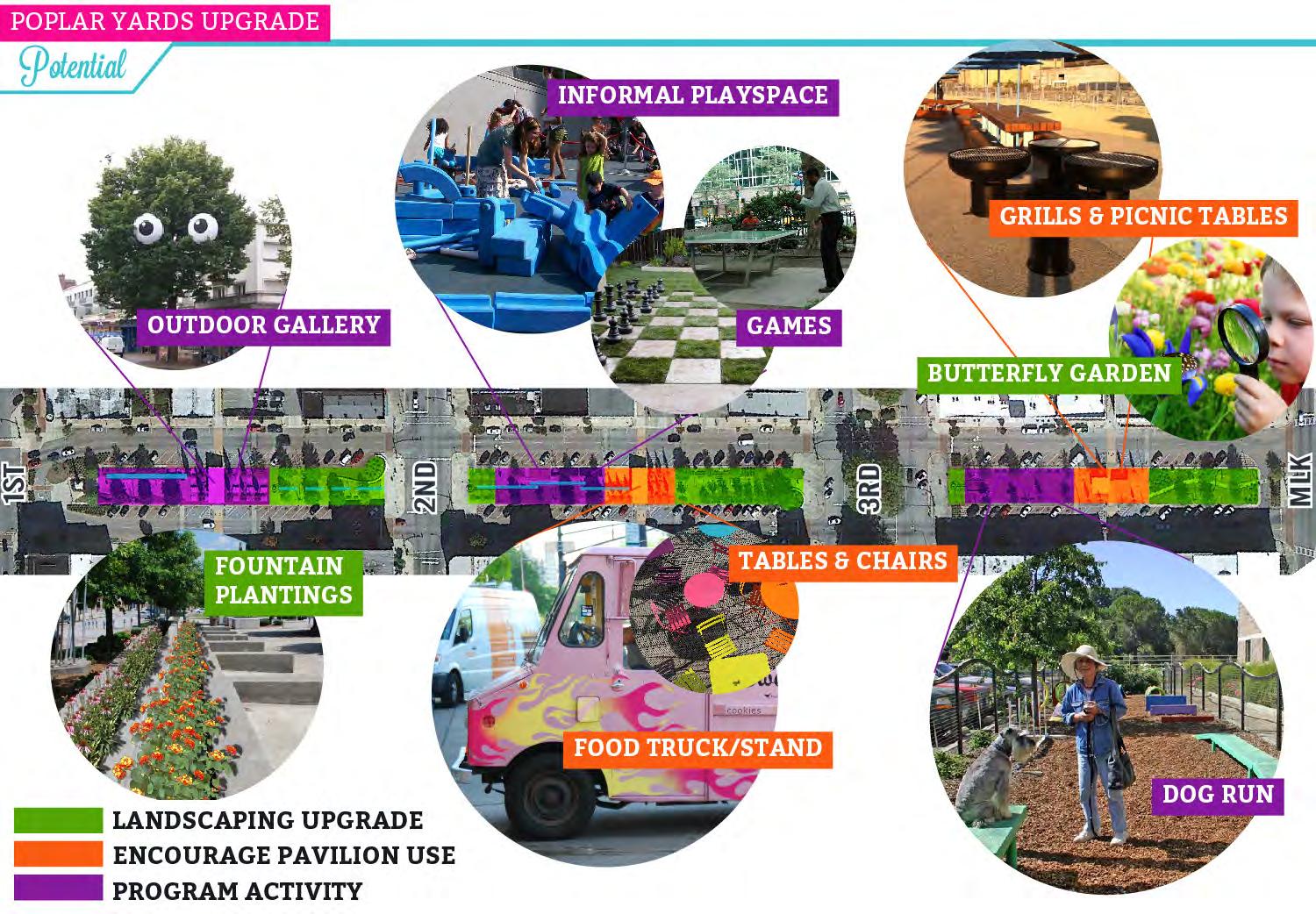
Poplar Yards Upgrade the landscaping and programming at the Poplar Yards. Given that the fountains are not functioning, the City should determine whether or not it is feasible to turn them on again and maintain them as fountains. If not, they should fill them with soil and convert them to planters so they once again become an amenity to the park. In addition to the fountains, the grass in the median has bled into the gravel pathways making the park circulation indistinguishable from the lawn areas. To make the design of the park easier to maintain, the existing gravel should be replaced with concrete or pavers to restore the intended circulation patterns. Some of the larger passive lawn areas, such as along the winding path between 3rd street and MLK, are underutilized. By incorporating a landscape destination, such as a butterfly garden, residents would not only have something that is more beautiful, they would be attracting more users to the park. As for programming upgrades, the seating underneath the pavilions is a little too rigid and uncomfortable. By replacing the formal layout of the benches with flexible seating options, such as picnic tables, movable furniture (as in Strategy 1.2a) and community grills, nearby residents would be able to take advantage of the shade structures for informal gatherings and family events. Other ways to activate the Yards include incorporating a rotating outdoor gallery for public art near the concrete symbolic ‘hay bails’ between First and Second streets, providing informal play spaces, inviting food trucks, and fencing in a small dog run. Signage that includes the name “Poplar Street Yards” with a bit of background on the site will also help promote the uniqueness of this space in the near term.
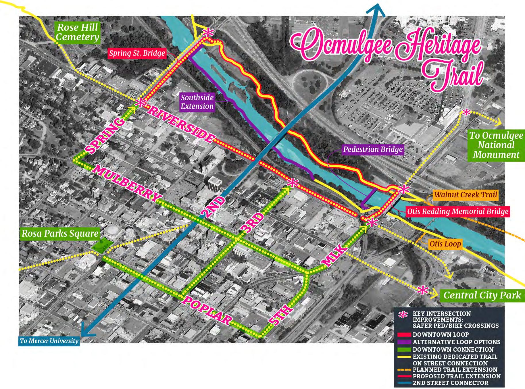
1.2c) Integrate the Ocmulgee Heritage Trail as a key downtown amenity
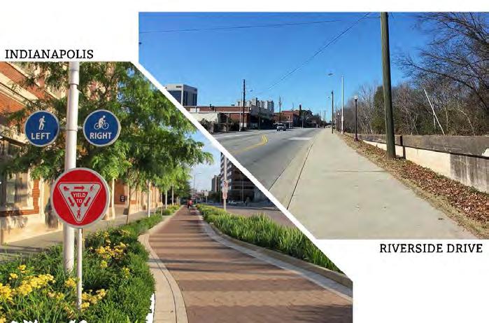
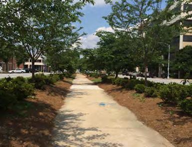
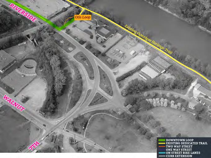
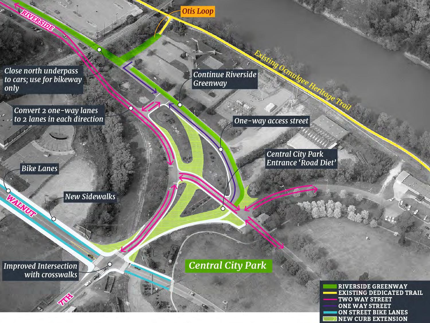
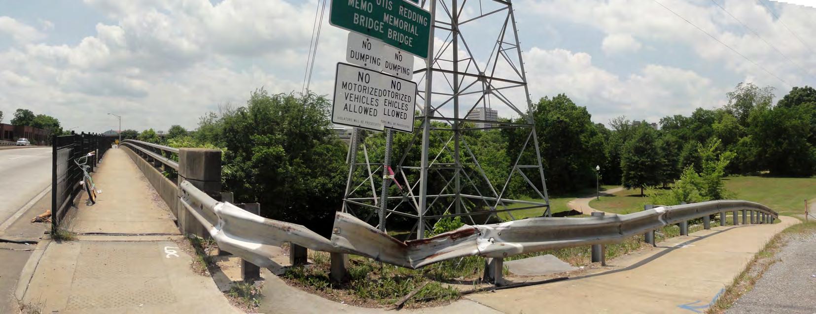
Background: A recurring theme throughout the community engagement process was the desire to foster a better connection to the Ocmulgee River. While most of downtown is within ¾ mile (or a 15 minute walk) of the River, as seen on Appendix page 27, existing access points are not always visible, clear, or welcoming. The trail has proved successful in drawing people from across Macon to the River. However, the trail’s location across the River creates a gap between this amenity and downtown. Currently, the side of the River adjacent to downtown has the least mileage of dedicated trail, linking just past Gateway Park where the Otis Redding statue stands to Central City Park. Continuation of this part of the trail is constrained by topography, existing rail lines, and costs. In 2011, a $500,000 investment was made to improve the sidewalk on the north side of Riverside Drive to provide an on-street connection on the downtown side of the River. While this sidewalk is an important step in continuing the trail, additional improvements have the potential to transform the roadway as a greenway in the event that the dedicated trail on the south side of the River is deemed unfeasible.
The far side of the River, including the forthcoming Walnut Creek Trail, provides a more traditional (and much loved) river trail experience, providing a great asset for the Urban Core. Access from downtown to the trail is difficult; trail users must either cross the Otis Redding Memorial Bridge (MLK) or the Spring Street Bridge. These bridges were not designed with bicyclists or pedestrians in mind, and neither includes safe bicycle access. There is limited protection buffering between cars and pedestrians. The Georgia Department of Transportation’s I-16/I-75 Improvement Project includes plans for expanding the Martin Luther King, Jr. Boulevard Bridge to six lanes with a raised, landscaped median. Plans also call for it to be reconstructed as a pedestrian friendly gateway to Macon with 10-foot sidewalks and lighting. The design for the bridge has not been finalized, though preliminary designs for the bridge expansion can be found online at http://www.i16i75.com. Given the importance of the MLK, Jr. Boulevard Bridge connection and its role as a major gateway to downtown Macon, this expansion is an opportunity for the Urban Core to partner with GDOT in creating a bridge that is not only visually appealing, but also an integral greenway connection in the Ocmulgee Heritage Trail system.
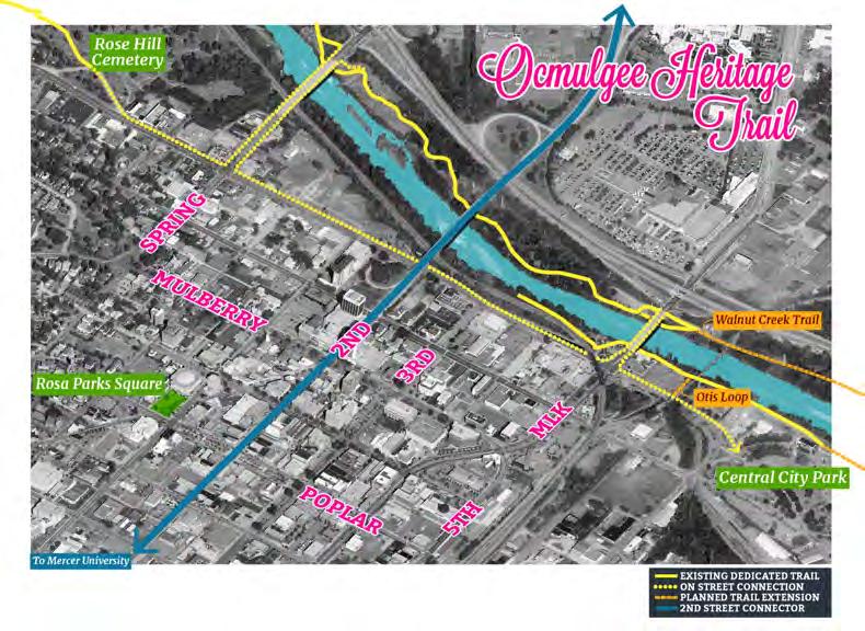
Key ideas: Downtown River Loop, Riverside Drive greenway, riverfront trail, median improvements, on-street bike lanes, bridge improvements
Actions: Downtown River Loop Create a connected, continuous Downtown River Loop as part of the Ocmulgee Heritage Trail Network. Consider two options for this:
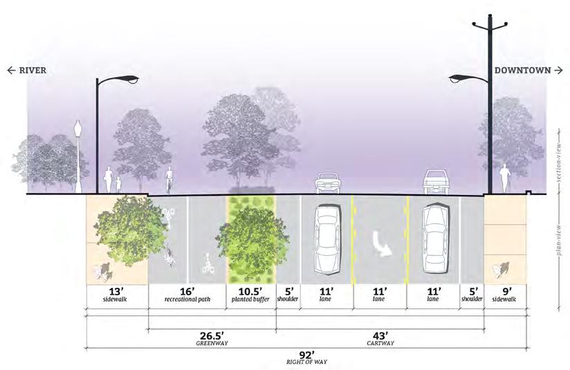
1) Riverside Drive greenway Design and build a true greenway along Riverside Drive. Existing traffic volumes along Riverside Drive between Spring Street and MLK Boulevard do not require more than four lanes. By re-allocating space to create a dedicated trail along Riverside Drive, the total loop length would be 1.7miles.

2) Riverfront trail Alternatively, create a riverfront trail connection along the south shore of the Ocmulgee River. As demonstrated by other cities, the trail can be designed to be beautiful but also fully floodable to accommodate the rising River. In this instance, Macon could have a trail loop along the water on both sides of the River. The total loop length would be 1.5miles.
HOW IT’S DONE ELSEWHERE:
Vera Katz Eastbank Esplanade, Portland
At 1,200 linear feet, the floating walkway is the longest of its kind in the United States and offers the sensation of walking on water. The adjoining 120-foot public boat dock provides moorage for recreational boaters as well as space for a future river taxi and other commercial uses.
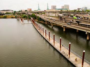
// Length: 1.5 miles Cost: $30M Completion: 2001
Schuylkill River Trail Boardwalk, Philadelphia
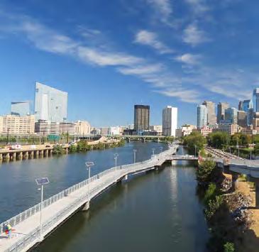
The boardwalk, which connects the Schuylkill River Trail from Locust Street to the South Street Bridge can withstand floods, ice, and heavy rains. The lights were designed to keep working no matter what Mother Nature brings including large logs, branches and other debris that sometimes come down the river and wind up on the trail. The boardwalk also includes a solar light system designed to work even when the boardwalk is underwater.
// Length: .38 miles Cost: $18M Completion: 2014
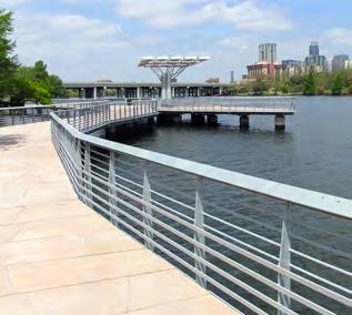
Boardwalk at Lady Bird Lake, Austin
This boardwalk features over 300 piers, 2,200 pre-cast concrete deck planks, 13,000 LED lights, 1.3 million pounds of structural steel, 7 viewing areas, an ADA accessible pier, and a new trailhead restroom.
// Length 1.3 miles Cost: $28M Completion: 2014
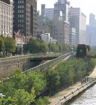
Allegheny Riverfront Park, Pittsburgh
While technically not a boardwalk, this trail traverses a 25-foot grade change. The path is 15-feet wide to accommodate walkers and bikers. The cantilevered section of the walkway sweeps out over the river and around the base of an intersecting bridge. The trail withstands fierce annual floods that can surge as much as twenty feet above the river’s mean pool level.
// Length: .75 miles Cost: $11M Completion: 2001
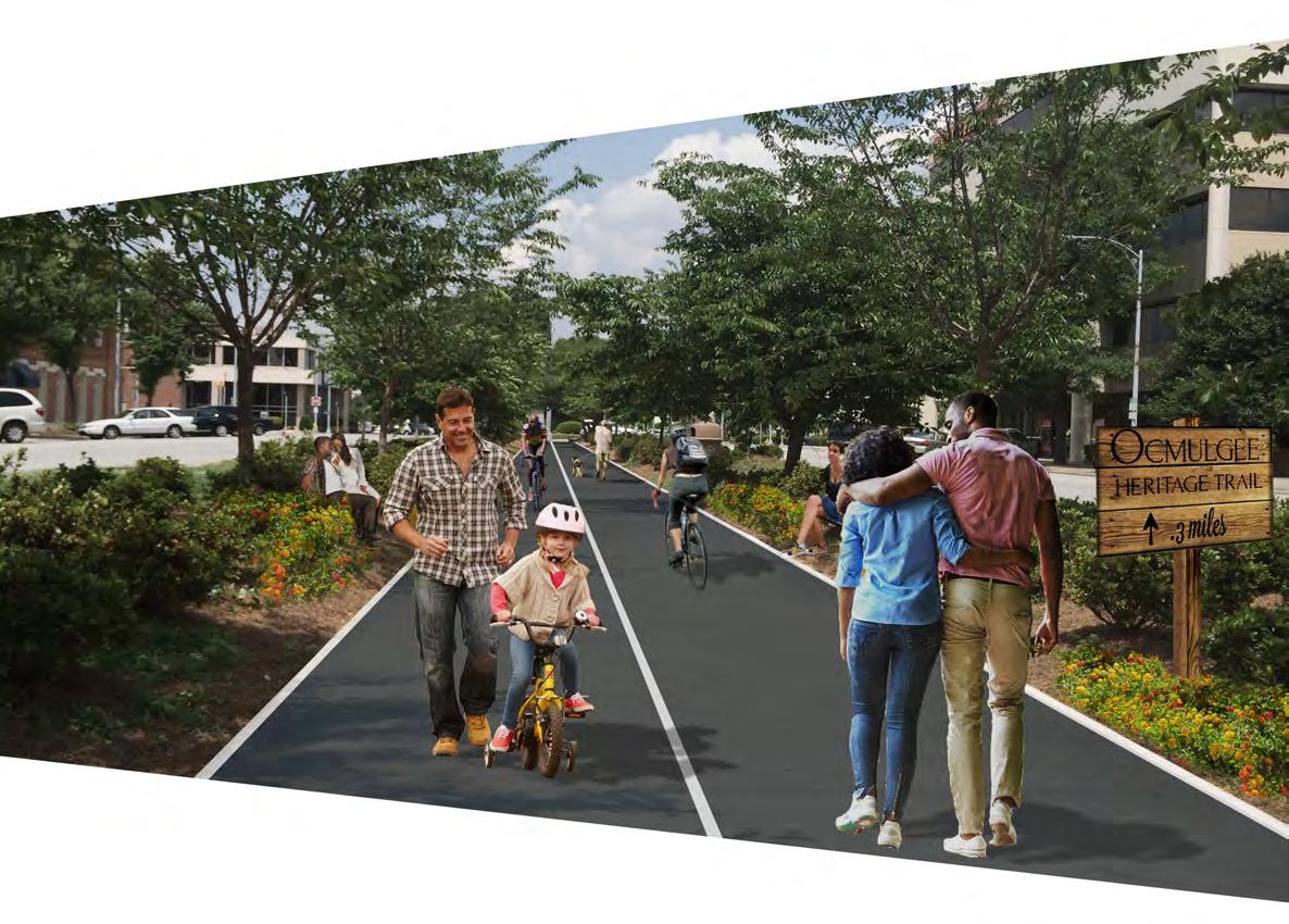
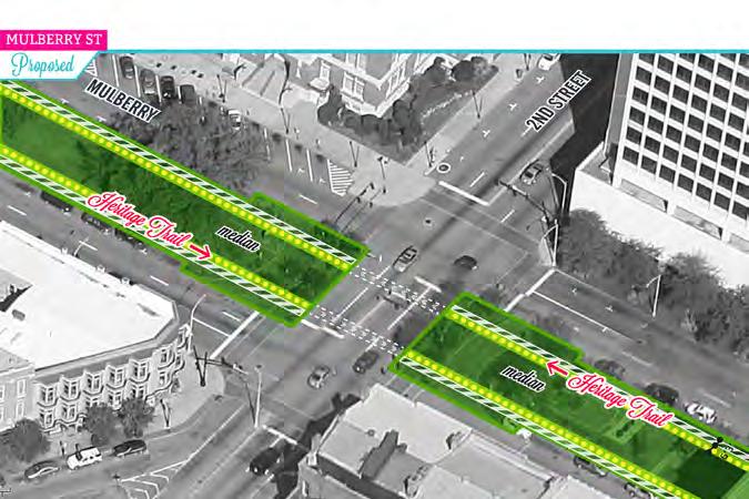
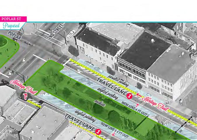
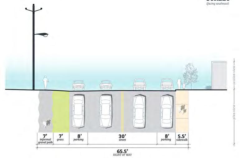
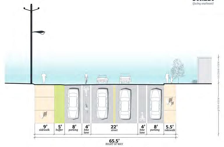
Median improvements & On-street bike lanes Extend the Ocmulgee Heritage Trail through the Urban Core and connect to the Downtown River Loop via medians and on-street lanes (e.g. Third Street, Mulberry, Poplar medians). Why stop the Trail along the River? Imagine if, regardless of where you live or work in the Urban Core, you could easily access the River. This is an experience few other cities can offer. Other cities are spending millions to create trails within new street medians. In Macon, the medians are already part of the urban fabric. By simply redesigning the middle of the Third Street median as part of the Heritage Trail system, the trail could extend to meet Riverside Drive. The design, as seen in Figure 20, would welcome both bicyclists and pedestrians. This approach could also apply to the Mulberry Street median, though here the redesign would widen the existing sidewalks on the outside of the median. This would preserve the large canopy trees in the middle of Mulberry’s median. The Poplar Street median would be harder to redesign to accommodate a trail. In this case, the trail could be integrated along the street, designed to provide enough protection from moving cars and retain the existing on-street parking.


With improvements planned for Central City Park, the on-street trail network should also extend along Riverside Drive and Walnut Street to meet this large urban park. Treatments on Riverside proposed between MLK and Spring Street can be extended all the way to the Park entrance while retaining two-way car traffic.
Bridge improvements Establish safer bridge connections to make walking and bicycling over the bridges safer. Two important existing bridges connect downtown to the existing Ocmulgee Heritage Trail, the Spring Street Bridge and the MLK Bridge. For Spring Street*, the opportunity is to take one vehicular lane and repurpose it for a multipurpose trail, buffered from traffic. There are more than enough lanes to handle traffic even during rush hour. For MLK, there are two options to create a clear trail connection:
1) Expand the proposed bridge extension to allow for a wider north edge to serve as space for the trail or;

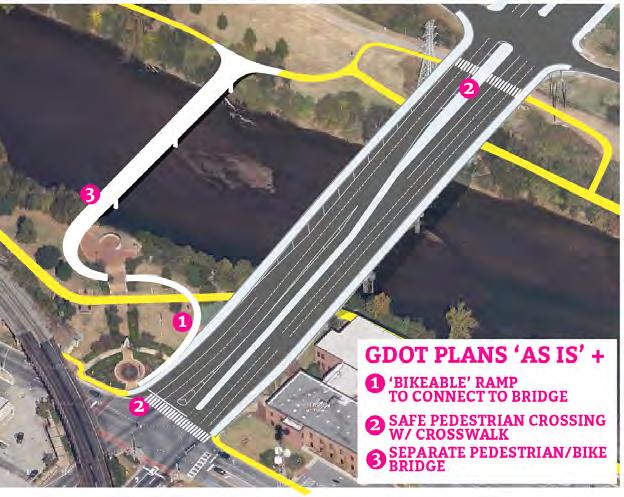
2) Redistribute the space dedicated to sidewalks within the proposed GDOT bridge expansion to create a larger trail connection on the north side. Discussion with GDOT is essential to determine what options may be available in light of the I-16/I-75 Interchange Project. If the width of the bridge is non-negotiable and a buffered pedestrian experience is not possible, a new pedestrian bridge from Gateway Park over the river would provide a direct link from MLK to the existing Heritage Trail, albeit at greater cost to construct, as seen in Figure 25.
The existing access across the River does not provide pedestrian safety (there are no crosswalks) nor does it feel safe to bike from Riverside Drive to the north side of the River.
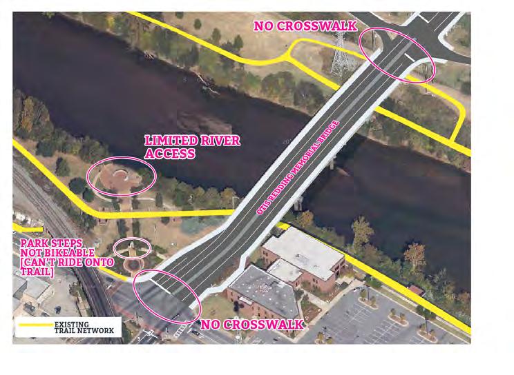
Existing GDOT expansion plans call for 3 travel lanes in each direction and a center turning lane / median, as well as a 10’ sidewalk on each side. If GDOT cannot include a greenway in their bridge design, a new pedestrian bridge could serve as the main pedestrian connection across the River.
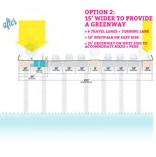
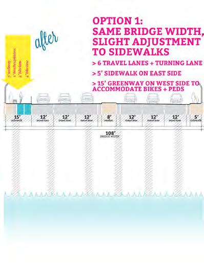

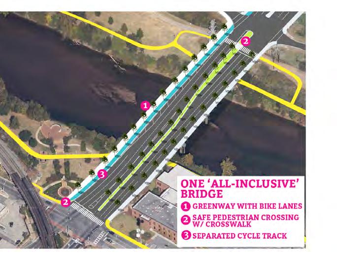
In the event that GDOT can alter their plans to include a greenway and enhanced pedestrian experience, there are two options to consider. Option 1 is the same planned width of the GDOT plans, but instead of 2, 10 foot sidewalks, reconfiguring the design to have one 15 foot greenway and a 5 foot sidewalk. The more preffered option 2, includes a 25’ greenway to allow for recreation ammenities on the bridge as well as a buffered cycletrack . Both of these options shows the bikeway on the west side of the bridge, as to link downtown, and the Gateway Park, to the Macon Coliseum.
Goal:
1.3 PROGRAM DOWNTOWN’S SOCIAL LIFE AND BUILD THE LOCAL AUDIENCE
1.3a) Maintain support for existing events and add new programs
Background: Events and programming will complement the physical transformations to the public spaces in the Urban Core. Events and programming form the beat of community life and offer the opportunity for Macon’s charm and creative spirit to shine through. Having a broad palette of events for residents and visitors to choose from is important for serving diverse interests. Regular events – both new and existing – can tie communities together and generate a consistent stream of support for local businesses. One-off events generate buzz, offering something exciting for residents while enhancing the appeal of the Urban Core for visitors and newcomers. Place-specific programming can activate spaces that have inherent value but are not currently used to their full potential.
Key ideas: existing programs & events; new events & programming: oneoff/temporary events, regular events, place-specific programs
- EXISTING PROGRAMS & EVENTS - - ONE-OFF/TEMPORARY EVENTS -
• First Friday
• First Saturday Village Market in Mercer Village
• Mulberry Market in Tattnall Square Park
• Second Sunday Concert Series
• Bragg Jam
• Cherry Blossom
• Roof-top Pop-Up (dinner and/or dance party)
• Beer Garden
• Mini-Golf
• Ice Skating
• Open Streets
- - REGULAR EVENTS - - PLACE-SPECIFIC PROGRAMS -
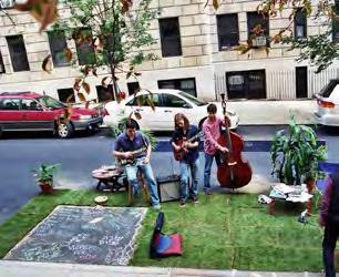
• Spring Parklets
• Park(ing) Day
• Food Truck Rally
HOW IT’S DONE ELSEWHERE:
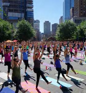
• Programming for downtown medians, e.g. yoga, fitness, sandbox for kids, wildflowers/bird & butterfly gardens, informal play spaces
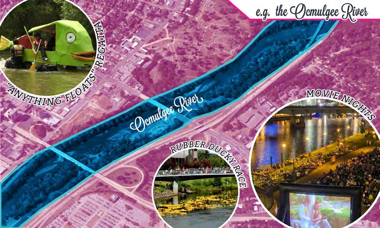
• Riverfront (movie screenings, night cruises, rubber ducky race, DIY float race, etc.)
• Downtown Senior Center
Anything that Floats Race, Key Largo, Florida Keys keylargoanythingthatfloatsrace.com/about-us/
This reflects work done by the Friends of the Trail a few years ago on the Ocmulgee. The race in Key Largo involves a halfmile course in which participants are challenged to be resourceful and use items from around their home, including PVC pipes and buckets, pool noodles and lawn furniture. Prizes are awarded to best-costumed crew, most creative vessel, fastest boat, best hard-luck story, and the vessel containing the most participants (that still floats). The event is organized by the Key Largo Merchants Association, a non-profit established to host community events in Key Largo.
Actions: Existing programs & events Macon’s Urban Core already hosts an impressive range of regular programs such as First Friday, Mulberry Market, and the Second Sunday Concert Series as well as annual events like Cherry Blossom Festival, Bragg Jam, and Design Wine and Dine. Consistency is key, so keep up the good work and maintain the Urban Core’s calendar of existing events and programs.
New events & programming whether singular, temporary, or recurring, should target underutilized spaces primarily. The tops of buildings with underutilized parking lots, for example, are interesting spaces for an occasional pop-up event with a view. Regular events sponsored by MAP should utilize locations that will generate foot traffic and increase spending at local businesses. NewTown and College Hill Alliance, with experience in bringing creative programming to the Urban Core, can offer support for new events, but new players will need to step up to help as well. Private businesses can develop events that contribute to the Urban Core’s sense of place if well marketed to build on the brand; business-based specials from karaoke to trivia to live music will help add vibrancy and draw customers to area businesses.
The emerging downtown neighborhood association will be integral in getting one-off pop-up events off the ground. Approach potential sponsors from small local businesses to larger employers and institutions. Yoga and fitness instructors could offer “pay-as-you-wish” classes in the medians. Ocmulgee Outdoor Expeditions and Riverkeepers or Friends of the Trail could collaborate in bringing a DIY float race to the Ocmulgee River.
Certain events and programming are better suited for busier areas. The bustle of Second Street lends the street to parklets and Park(ing) Day. Spring parklets could start on a) Second Street between Cherry Street and Mulberry Street Lane and b) Poplar Street between First and Second Streets. The UDA or Parking Authority would be best suited for organizing the rental of parking spaces for the spring parklets from the City-County. Organize a Park(ing) Day within the Urban Core and invite local schools, institutions, community groups, and businesses, to participate by dreaming, designing, and building temporary park spaces for a day in place of a parking space. Hold food truck rallies in parking areas that are close to nightlife, such as the Cherry Street Plaza. The temporary reduction in parking spaces due to occupancy by the food trucks will be more than made up for with the increased foot traffic the trucks will generate.
While many community events and programs take place outdoors, others might find permanent homes in underused spaces indoors. Seek indoor space and consider a satellite Senior Center in downtown. Successful downtowns need residents of all ages, and likewise, elderly residents require services in close proximity to where they live. Currently, many seniors live in the Dempsey at Second and Cherry in the center of downtown and would benefit from programs and space for socializing nearby.
HOW IT’S DONE ELSEWHERE:
Open Streets, North America
Open Streets events temporarily close off streets to traffic to allow for temporary programming and activities, such as walking, biking, games, dancing, yoga, and small markets. These events transform streets into spaces defined by public use as opposed to mostly automobile use. Open Streets events are growing in popularity, with over 100 events documented in North America so far. openstreetsproject.org
Park(ing) Day, worldwide
Park(ing) Day is an annual global event in which participants transform parking spaces into temporary public places. Participants have used the space for art installations, musical performances, playgrounds, parks, and games, among other activities. Park(ing) Day takes place on the third Friday in September, every year. parkingday.org
Philadelphia Parklet Program, Philadelphia, PA www.universitycity.org/parklets
Parklets are raised platforms spanning two parking spaces with tables and chairs that offer places to sit, relax, eat, and enjoy the life of the street. The Mayor’s Office of Transportation and Utilities works with local business owners and community groups to bring parklets to neighborhoods.
Goal:
1.4 FOSTER A SENSE OF ARRIVAL AND MAKE GOOD FIRST IMPRESSIONS AT GATEWAYS
1.4a) Improve downtown approaches from main thoroughfares
Background: The points at which main thoroughfares enter the Urban Core are the first places that visitors see when they arrive here. These gateways are one of our greatest opportunities to create a sense of arrival, make good first impressions, and must send the message that the Urban Core is vibrant, well-kept, and unique. Signage (see Strategy 1.4c) must incorporate the brand of the Urban Core (see Strategy 1.5a) along with place names and wayfinding that increase visibility of destinations and navigability of the Urban Core as a whole.
Key ideas: landscaping, signage, public art
Action: Landscaping, signage, public art Incorporate large entrance signage, plantings, and public art at the main gateways into the Urban Core:
• Riverside Drive at College Street and reaching toward Second Street
• Spring Street Bridge
• MLK, Jr. Bridge
• MLK Jr. Boulevard at Riverside
• Second Street Bridge
• Forsyth Street
• Second Street Rail Bridge
Strategy 1.4b illustrates gateway opportunities at major institutions and destinations in the Urban Core.
Entrances to Macon: Examples:

Action: GatewaysBeautify
1.4b) Capitalize on local institutions and assets as gateways to the Urban Core
Background: Local institutions and assets are gateways to the Urban Core as well in that they are primary destinations. They often consist of stately and beautiful buildings, but the approaches from adjacent streets are at times confusing and can inhibit the appreciation of Macon’s built form. Furthermore, many of the key gateway intersections in the Urban Core were designed at a time when the main objective was to minimize delay for vehicles entering and exiting downtown. Redesigning these intersections will enhance connectivity, slow speeds and enhance the sense of arrival, and ensure the safety and comfort of all users.

Key ideas: alterations to circulation patterns, intersection reduction, landscaping, beautification
Actions: Redesign intersections to better announce major institutions and local assets, as well as to create safer travel conditions, maximize green space, and incorporate bike lanes where possible. Opportunities include:
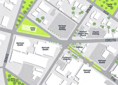
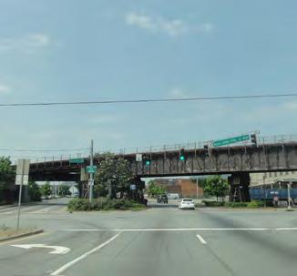
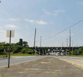
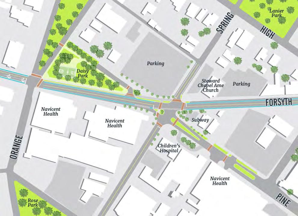
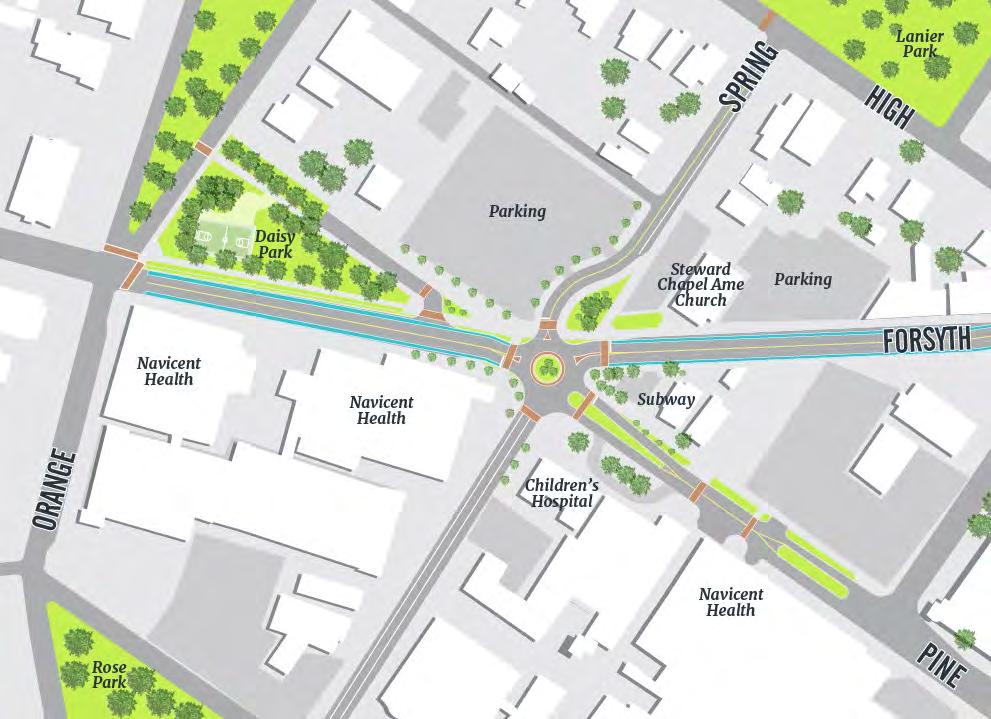
Navicent gateway at Triple Triangle Park: One of the primary front doors of Navicent Health is the intersection of Spring, Forsyth, and Pine Streets. This five-legged intersection is very large and confusing for all modes of transportation. Confusion threatens safety when vehicles are making a turn while pedestrians are in the crosswalk.
MAP proposes two options for boldly announcing the location of Macon’s largest employer. Option 1 would reduce the size of the intersection by providing a new pedestrian island crossing Forsyth along Spring Street. The design would consist of a small landscaped island, which would still serve to slow and direct traffic, in addition to pronounced crosswalks and curb bumpouts.
Option 2 is to include a roundabout with pronounced crosswalks to include landscaping in the intersection, ease travel, and create safer conditions. While this option provides the opportunity for more greening and fewer conflicts between pedestrians and motorists, additional assessment about advantages and drawbacks for ambulances traveling through the roundabout is needed. Additionally, this option would require a considerable amount of right-of-way, and would require realigning Spring Street through an existing Navicent surface parking lot.
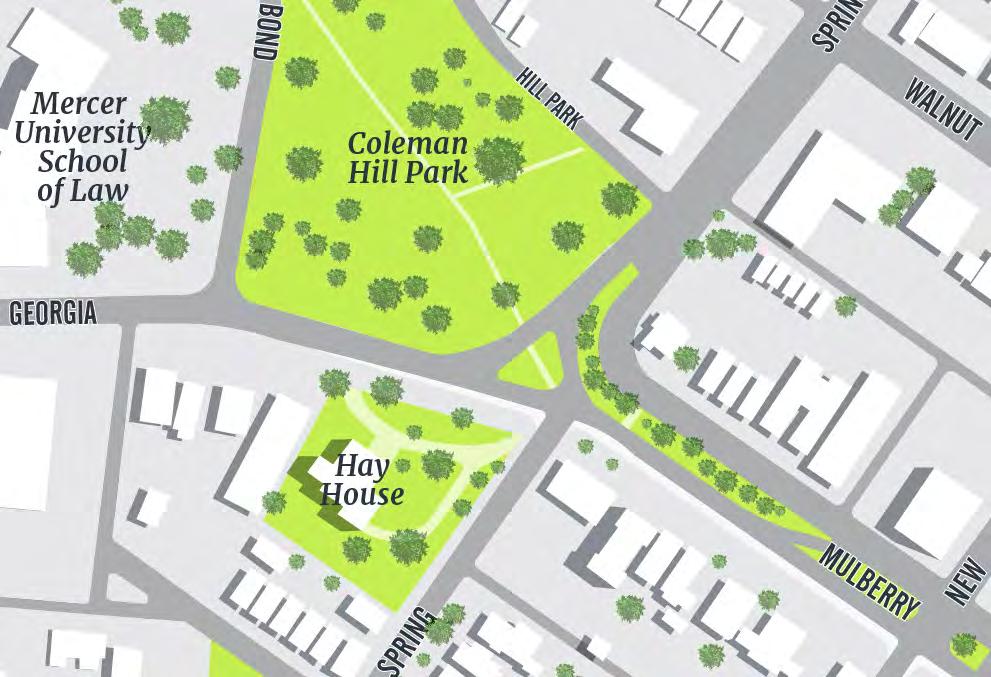
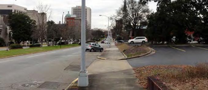
Spring & Georgia by Mercer Law & the Hay House: The forecourt of the Hay House is an unsafe intersection. A redesign could make it safer and more attractive through an extension of Coleman Hill Park to connect with the existing traffic island in the middle of the intersection, a realignment of Spring Street so it meets the intersection at a less acute angle, and the incorporation of bike lanes connecting Mulberry Street to the Ocmulgee Heritage Trail. A traffic signal should be installed at the intersection along with international style crosswalks and pedestrian countdown signals. These improvements provide a beautiful forecourt for the Hay House, create a safe pedestrian entrance at Coleman Hill Park and will not impact the entrance gates to the Hay House driveway, providing instead, safer access to this historic resource.