
Iris Quping Li Selected Works 2022


CONTENTS Page 01 01 02 03 04 05 06 Page 08 Page 12 Page 17 Page 23 Page 27 Reintegrating Chronicles Three-fold Lateral Habitat F(L)ood No Man’s Land Growing Between Leftover A Gradual Reopening Plan to Reactivate the Post-Mining
Place-Making
-
An
-
A
Brownfield
in Mitigating Conflicts Be
tween Graffitists and Residents
Architectural Reflection on Post-Pan
demic Public Space
Flood-Resilient Terrace as a Response to Climate Change An Annual Field Study of the Ecosystem on Urban Fallow Lots Reusing Leftover Construction Materials in Landscape Design
REINTEGRATING CHRONICLES
A Gradual Reopening Plan to Reactivate the Post-mining Brownfield Graduation Thesis at University of Toronto
Date Completed: April 2022
Location: Fuxin, China
Area: 7.9km²

Type: Individual
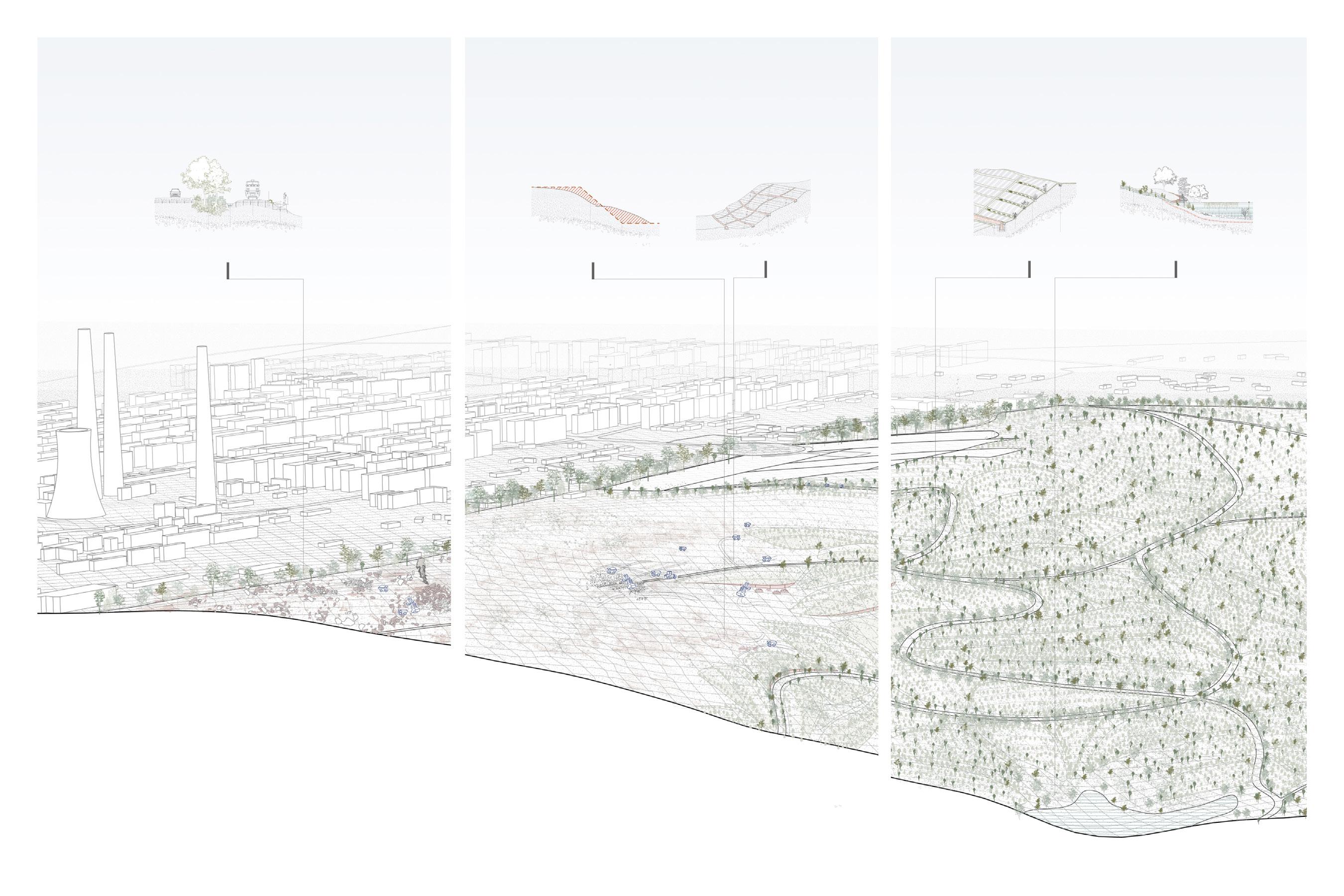
When the coal ran out, the land lost its “productiveness”; for people of Fuxin, the eight-square-kilometer coal pit became a troublesome scar next to their city. Although the Fuxin government has proposed to develop livestock and ecological agriculture as its redevelopment plan, heavy pollution from the untreated coal pit obstructs the implemen tation of any new proposal for the surrounding communities.
Based on relevant regional studies, this thesis constructs a contaminant distribution mod el and an expected vegetation restoration model of the Haizhou coal pit, in which a major portion of the restored plant species consist of nectar plants or plants with forage poten tial. Thus, this thesis proposes honey-forage production as the ultimate program after remediating the contamination. The site will gradually reopen to the public as the trans formation becomes visible and allow people to reconnect to the land. In 35 years, the site will be restored to natural productiveness and reintegrate into the surrounding context, supporting the livestock redevelopment attempts of the local community.

1 01
Fuxin city growing next to the Haizhou coal pit
CURRENT REDEVELOPMENT ATTEMPTS
After the mines were closed, the Fuxin government proposed to develop livestock and ecological agriculture as a future plan. Under this policy, the former miners’ villages (Points A, B, and C on the left map) around the Haizhou coal pit began to breed cows and poultry. However, the heavy pollution from the untreated coal pit became an obstruction to their new industry.

A: Minxin Village Construction Material &
B: Gaodeyingzi Village
Livestock -- Poultry

C: Xishan Village
Livestock -- Cow & Meat Packing
MINING RESIDUE CAUSES 4 CONTAMINATIONS
Mining residue coal gangue - remains on site. Its combustion has caused 4 interrelated environmental issues: landslides, soil and water contamination, and, since the edge of the city is only 600m from the pit, toxic smoke that severely affects people’s health and life.

2 MAJOR MINING
IN FUXIN Xinqiu Coal Pit Haizhou Coal Pit Dongliang Coal Pit Sunjiawan Coal Pit Aiyou Coal Pit
Closed: on March 30, 2001
Closed: on May 31, 2005 A Gangue Accumulation Area 1 Gangue Accumulation Area 2 B C • Closed: on March 30, 2001 Major Coal Mines Highway Fuxin’s City Core Regional Road Railway Contour: 20m • Closed: on May 31, 2005 • Closed: on September 28, 2015
AREAS
•
•
Livestock
Combustion Toxic Smoke Exacerbate Landslides Soil and Water Contamination
RESEARCH MODEL I: Contamination Zoning Model
The Contamination Zoning Model gathers data from several separate field studies and derives 6 risk layers, such as metal contamination measurement, landslide contours and coal gangue distribution. Overlapping these layers forms a unified risk zoning map of the Haizhou coal pit. Generally, different metal contaminated areas are located on the slope of the pit, with the north side having a higher landslide risk, and zone A being relatively less contaminated. This zoning becomes the basis of the remediation process.

3
Cu contamination Cd contamination Zn contamination coal gangue distribution surface temperature (July 23, 2021) landslide risk level 28~35℃ 3.0 35~39℃ 2.5 39~42℃ 2.0 42~46℃ 1.5 46~50℃ 1.0 landslide risk run-off simulation D D C C D A A A B B A F F G G E E exposed gangue piles 1: 8000 LEGENDS landslide risk area key risk: coal gangue combustion key risk: landslide + gangue combustion key risk: Cd contamination key risk: landslide + Zn contamination key risk: landslide + Cd, Zn contamination key risk: Ni, Zn contamination less contaminated area
RESEARCH MODEL II: Vegetation Restoration Model
In 25 years, more and more nectar plants will grow on the post-mining contaminated soil
The studied discharge site was used to dump the soil and gangue from the Haizhou coal pit, and stopped operation 25 years before the coal pit was abandoned. Since the two sites have the same soil and gangue composition, the study of restored vegetation on the dis charge site becomes a model to predict the vegetation restoration of the Haizhou coal pit.
Major Nectar Plants
Supplementary Nectar Plants
Site Study Location
Haizhou Coal pit
Studied Discharge Site
Coal Gangue
New Vegetation of +11~20 years

New Vegetation of +21~35 years

Lack of top soil, plants hardly survive
New Vegetation of +0~10 years
Dominated by annual plants
Pioneer plants appear, including some nectar plants
Arbors appear
Dominated by perennial plants, more nectar plants appear
Shrubs become the dominated plants
Zn²⁺ Cu²⁺
Operation Stops
Cd²⁺
+<8 years
Topsoil Thickness: 2-6 cm
Soil Organic Matter: 2.146%
Topsoil Thickness: 2-10 cm
+8~15 years Cd²⁺ Cr6⁺
Topsoil Thickness: 5-15 cm
Soil Organic Matter: 5.491%
+25~35 years
Topsoil Thickness: 15-28 cm
Soil Organic Matter: 8.710%
Topsoil Thickness Increased as Time Went by
4
Soil Organic Matter: 3.120% Ni²⁺
+15~25 years
PROPOSED MASTERPLAN

Site-wise remediation, circulation and drainage system completed in 3 phases
The proposed construction is completed in 3 phases, starting from the least contaminated area, followed by the drainage construction and planting of remediation vegetation. The site will then be gradually opened to the public. The drawing shows the completed masterplan by the end of phase 3, where the circulation forms a vertical path and horizontal loop network, and interceptors collect all the run-off and direct it into the lake for purification.


GRADUAL REOPENING: Start from the least contaminated area
Phase 3: 21~35 years
Goals: site-wise circulation / drainage systems; planting in contaminated areas; honey and forage production
Phase 2: 11~20 years
Goals: major remediation planting; address the landslide risk and runoff issues; reuse gangue bricks in construction
Phase 1: 0~10 years
Goals: remediate most urgent risks; make the transformation visible to the public
5
0 SCALE 1:10000 Purification Lake Proposed Circulation Proposed Drainage Gathering Space Risk Zoning Boundary Miners’ Memorial 150m 300m 600m 1200m
REMEDIATION PLANTING PROPOSAL

Phyto-enhancement: preference is given to plants with nectar/forage quality


6 Phase 1 The Green Buffer nectar plants interceptor ditch tour train on existing coal train tracks sightseeing boardwalk original terrace eliminated slope gangue brick retaining wall retaining wall planting tank plant fiber reinforce mat interceptor ditch interceptor ditch remediation plants insulation layer artificial lake with remediation plants Landform 1: slope sub-division Landform 2: slope reinforcement Reinforcement Details Interceptor and Runoff Purification Phase 2 Phase 3
Forage Nectar Plants
35 YEARS LATER, HAIZHOU COAL PIT
Ecological Base & Honey-Forage Production


HONEY AND FORAGE PRODUCTION

7
1: 1000 Landform Model
Spring Nectar Plants Flowering Season Forage Harvest Season Summer Fall 3 1 5 7 9 11 12 R. pseudoacacia Tilia tuan Szyszyl. Ziziphus jujuba Melilotous albus Melilotous albus Amorph fruticosa L. Snow Season, Limited Access Forage Harvest Vitex chinensis var. heterophylla Lespedeza davurica Astragalus sinicus L
LATERAL HABITAT
An Architectural Reflection on Post-Pandemic Public Space Course Work at University of Toronto
Date completed: April 2021
Location: Toronto, Canada
Area: 14000m²
Type: Individual
This project was designed during the worst months of the Covid-19 pandemic, when the indoor public spaces that constitute the city were perceived as ‘’life-threatening.’’
As a response to this situation, Lateral Habitat re-examines the private-public arrange ment in residential towers. It aims to bring city public spaces to residents more safely and playfully. By flipping the traditional vertical arrangement of the public podium and private units, this project provides two distinct vertical circulation paths from the ground floor to avoid unnecessarily passing through high-risk public space to get home. Instead, on each floor, there is an entrance to the public side, so people can go to the public pro grams directly from their units.


8
02
Flipping Public Programs’ Arrangement
TYPICAL FLOOR PLANS AND 3 TYPES OF UNITS


In the main volume, the public and private sides are separated by a screen; residents can go to the public side directly from their units through the screen.

Residence Type C Bunk bed for two people
Residence Type A For family - up to four people
Residence Type B Accessible unit for two people

9
A SEPARATE CIRCULATION FOR PUBLIC SPACES

In the main volume, the public and private sides are separated by a screen; both sides are equipped with vertical circulation systems. Residents can enter the public programs from the ground level by elevator and stairs or go to the public side directly from their units through the screen.


10
Dormitory Facing Residential Area View of Library from Public Corridor View of Study Rooms

11
HABITAT AND ITS CONTEXT
LATERAL
THREE-FOLD:

can I entice you to graffiti?
Place-Making in Mitigating Conflicts Between Graffitists and Residents
Assignment at Harvard GSD Design Discovery Virtual
Date Completed: July 2021
Location: Toronto, Canada
Area: 5600 m²
Type: Individual
Selection of Graffiti Complaints from this junction’s 311 calls (sample: 181,189 calls from 2021)

In Toronto West, there is a junction that has the severest battle between graffiti and neigh borhood “tidiness.” The data is astonishing -- more than 30% of 311 calls from here are graffiti complaints, 50 times higher than the city’s average 0.62% report rate. Graffiti occu pies infrastructure, residential walls, and almost all the on-site amenities. However, simply banning and removing graffiti could never solve the problem, nor does covering all public surfaces with grass, which is what the city has been attempting to do.
This proposal aims to legalize graffitists’ participation in urban landscapes and encourage the interaction between residents and the seemingly annoying graffiti culture. It proposes instead a three-fold public surface to substitute for flat lawns. While retaining the green area and maximizing their visibility from residents’ windows, designated vertical graffiti surfaces are erected in the park. Gravity pedals are installed in front of graffiti walls and connect to a pump-irrigation system. So every step of people observing or doing graffiti becomes vege tation-beneficial and community-beautifying.
12 03
GRAFFITI, GRAFFITI, GRAFFITI
The junction with the most graffiti compliants in Toronto
STRATEGY: FLAT LAWN THREE-FOLD GRAFFITI PARK


keep green space and legalize graffiti art

13
LEGENDS: 1: 1500 entrance graffiti area contours open space buildings Graffiti on Railway Sound Barrier Graffiti on Buildings Graffiti on Urban Infrastructures A A
Fold I Current Use: Flat Lawn Keep Lawn Area Graffiti Wall Addition Interactive Irrigation System Connecting Two Programs Fold II Fold III Irrigation Tank Step on Pedals Pressure Rainwater Sedimentation Tank Fold I Fold II Fold III
PUMP SYSTEM SIMULATION Frames from a video
These nine images are captured from the pump system simulation video. In this video, a concept hydraulic model is operated to show the irrigation-soak process when one person steps on the gravity pedals.

14 Original Level Original Level Original Level Soak Level- 1 Person Soak Level- 1 Person Soak Level: 1 Person 20 People 20 People 20 People 07/19/2021 15:33:02:01 1 4 7 2 5 8 3 6 9 07/19/2021 15:33:05:05 07/19/2021 - 15:33:08:03 07/19/2021 - 15:33:03:04 07/19/2021 - 15:33:06:04 07/19/2021 - 15:33:09:06 07/19/2021 - 15:33:04:03 07/19/2021 - 15:33:07:02 07/19/2021 - 15:33:10:02
PROPOSED PLAN

The proposal retains the original green space while incorporating appropriate vertical surfaces for graffiti through the cutting and folding of terrain.

SEEING STILL GREEN FROM STILL VIEWS, SEEING DYNAMIC ON THE GO:
Graffiti walls are most visible to circulating viewers
The multi-view oblique unfolds along the park and shows still views to the condos on both sides of the road and moving views when people pass by the park in vehicles or on foot. Green areas are maximized for condo residents looking from their windows, creating a calm environment, while the graffiti walls are more visible to those who pass by, intriguing them to have a closer look.
15
Form Iteration A: Graffiti Wall& Path Connection
Form Iteration B: Retaining Wall
Stable View: Green Space
Stable View: Green Space
LEGENDS: graffitists circulation passenger circulation still view moving view
Traveller View: Graffiti Area
VIEW FOR THOSE WHO WALK BY THE PARK
As people walk through the park, they will see the fluctuating graffiti walls. If they choose to walk closer and observe the graphics, they will discover the secrets of the pedal-irrigation.

16
F(L)OOD
A Flood-resilient Terrace as a Response to Climate Change
Course Work at University of Toronto
Date completed: December 2020
Location: St. Cloud, France
Area: 0.284km²
Type: Individual
Areas where flooding will become more extreme, 2050

St. Cloud Park is located in the western suburb of Paris, overlooking the Seine. Since the 15th century, the park’s boundary has expanded from a backyard fountain, an nexing surrounding farmland, eventually becoming a 460-hectare royal garden. 500 years history of being a royal garden has left a unique path design and heritage wa ter features in the park. After the mid-19th century, the royal garden was opened to the public and became the current St. Cloud park. A tramline and a highway were constructed between the park and the river Seine to improve regional transit.
Flooding was a historical issue at the park. Since climate change is increasing the fre quency and magnitude of ten-year and fifty-year floods, by 2050, the expected flood plain will devour the highway, tramline, and the edge of the heritage part of the park.
This proposal transforms the current under-utilized construction site into a riverbank - a flood-resilient terrace with an homage to the site’s farming history. The tram line and highway are elevated to prevent them from flood impact while reconnecting the park to the riverbank. The historical gravity-driven fountain hydraulic networks are leveraged to irrigate the vegetation during the non-flood season. With the flood-resilient terrace, a fifty-year flood will be stopped before hitting the heritage areas of the park.

17 04
St. Cloud
SEINE RIVER FLOODPLAIN


Flooding has been a major problem in the Seine River basin. Since a 1294 flood was first recorded, the river Seine has flooded many times throughout history, with larger flooding events occurring on average every 10 years.
CLIMATE CHANGE INCREASES FLOOD MAGNITUDES
According to the IPCC, by 2050, the global average temperature will rise by 2 degrees Celsius. Climato logists point out that such warming could aggravate snow melt and intense rain, which increase flood magnitudes (over a 10-year and 50-year return period) significantly. In past centuries, while the park was being renovated, the floodplain was also gradually expanding from the riverbank and approach ing the park. In 2050, the expected floodplain will eat up the edges of St. Cloud Park’s heritage areas.
18
St. Cloud Park
ST. CLOUD CULTURAL HERITAGE:
Gravity-driven hydraulic networks

MEDIATORY FRAMEWORK TO CO-EXIST WITH FLOOD IN 2050
Factors to Mediate
Context Privileged Expansion and Annexation of Farmland
Mediation
History Urban Farm for Everyone
St. Cloud Park sits on sloped terrain. With a 76m height difference over 1.1km, the fountains at the park are all powered by gravity. This hidden cultural heritage an interconnected hydraulic network, guides the water down to the fountains, and eventually pours into the Seine.
Cultural Heritage Drip Irrigation
Gravity-driven Hydraulic Network Tram & Highway Separate the Park and Riverbank
Flood Inundation Causes Traffic Disruptions
Transit Elevate
Climate Change
Increase in Magnitude and Frequency of Flooding
Flood-resilient Terrace

19
To Seine River
Water From Fountains

20 PROPOSED FLOOD-RESILIENT TERRACE
FLOOD IMPACT COMPARISON
Existing Condition
Proposed Flood-Resilient Terrace

WHY TERRACE: Flood Impact Analysis
50-Year Flood Level in 2050 slope slope + dike
50-Year Flood Level in 2050
Terraced √
When floods hit, the terraced riverbank’s shape reduces the impact force of flood waves and protects the internal features of the park.
21
Drier Level Moist Level Wet Level Wet Land

22
ST. CLOUD TERRACE IN FLOOD, 2050
NO MAN’S LAND
An
First Survey Completed: September 2022
Location: Toronto, Canada
Area: 262m²

Type: Individual
This is a story taking place on an urban fallow lot. As an attitude in the fight against gentrification, the owners left their asphalt plaza, decent lawn, and gravel parking lot unattended for three years until it became an artificially-made “no man’s land.” Their decision to continue has made the lot a valuable site for studying ur ban ecology and pioneer plants and comparing species changes annually.
The study method of this project is inspired by archaeological sampling. After dividing the lot into 1m*1m grids, I took a picture of each grid and stitched them together to generate the image. Three samples were taken for comparison – one on asphalt, one on soil, and one on gravel. Horizontally, the study compares pioneer species’ amount and abundance on three different ground conditions; vertically, the study documents the grid under human control and the same grid after three years of natural resilience; and the grids’ condition will be documented and compared in following years.

23 05
Annual Field Study of the Ecosystem on Urban Fallow Lots
Grid Division Details
286 GRIDS

24 1 2 3 4 5 6 7 8 9 10 11 12 13 14 15 16 17 18 19 20 21 22 23 24 25 26 27 28 29 30 31 32 33 34 35 A B C D E F G H J K
After taking pictures of individual grids within a week, 286 pictures were stitched together to document the plant recovery condition in the summer of 2022.
PLANT RECOVERY COMPARISON ON DIFFERENT SURFACE CONDITIONS
After three years of recovery, the first survey took H5, H12, and I32 to compare plants’ species and abundance in different ground conditions.


25
H12, Soil, 2019
I32, Gravel, 2019
H5, Asphalt, 2022
H12, Soil, 2022
I32, Gravel, 2022
SECTIONAL PROFILE OF SAMPLE GRIDS

The survey takes three diagonal sections on the three grids and documents their species, numbers of plants, plant height, and root length. For each ground condi tion, five of the most common species were collected and preserved for compari son in future years.

26 Asphalt Soil
Gravel
GROWING BETWEEN LEFTOVER

This project was initiated to make a home for 1, 368 leftover concrete bricks. They came from the concrete facades of several projects in the same neighborhood by an architecture office. Each project had some excess materials that were too little to re turn but too valuable to waste.
Since the house’s design used plenty of curves, the bricks’ layout summarized the prop erty’s geometrical language with circles. As the circular rows expand from the center, the gaps in between also widen, leaving more space for rainwater to penetrate while re maining walkable. Apart from the designated planting areas at each circle’s center, the gaps were intentionally left blank to welcome wild seeds. Here, the leftover materials and the unattended wild grasses co-habitate, as important as the house itself.

27 06
Reusing Leftover Construction Materials in Landscape Design
Professional Work at JA Architecture Studio
Construction in Progress
Location: Toronto, Canada
Area: 46m²
Role: Design Assistant, Drawing Production, Site Management
3 months after finishing the front yard, Oct. 8, 2022
Photograph Credit: Felix Michaud
REAR YARD PLAN AND STEPS’ SECTION


CONSTRUCTED FRONT YARD

28
Photograph Credit: Felix Michaud
Iris Quping Li MLA I Application Portfolio for Harvard Graduate School of Design
MY SINCERE THANKS TO MY FAMILY, MY TEACHERS AND COLLEAGUES, MY FRIENDS, AND MY DOG.
Especially,
My four referees: Behnaz Assadi, Simon Rabyniuk, Fadi Masoud, Derek Liddington; When I initially decided to apply, I didn’t expect could get such recommendations.
And people who saved my sss during the past year: My friend and work partner, mischievous annoying fluffy sea otter -- Tianyu Zhang (Louis)
Ultimate Ph.D. material and star airbnb host-- Ameen Ahmed
Off-white house owners and cat feeders -- JA Architecture studio
Snowproof Korean soldier -- Daniel Hyunsu Kim
Cooper human laser cutter -- Tianyang Sun
Strongest Amazon coder -- Shashwat Pratap
My student ID landlords -- Jierui Chen, Teresa Ziyi Chen, Kiana Xingtian Gong, and Larissa Lok-tin Ho
My last-minute thesis saver -- Ariadne Kaperonis-Bountris
My model picture picker -- Maria Xuhan Wang
