
International Research Journal of Engineering and Technology (IRJET) e-ISSN: 2395-0056
Volume: 11 Issue: 12 | December 2024 www.irjet.net p-ISSN: 2395-0072

International Research Journal of Engineering and Technology (IRJET) e-ISSN: 2395-0056
Volume: 11 Issue: 12 | December 2024 www.irjet.net p-ISSN: 2395-0072
Mohammed Saiful Islam
Town Planner, Sreepur Municipality, Local Government Division, Ministry of Local Government, Rural Development and Cooperatives, Government of the People’s Republic of Bangladesh
Abstract - The studyaims toillustrate howurbanplanning in Laksam Municipality, Bangladesh can be guided by a bluegreen infrastructure (BGI) network approach by considering its major drainage basins, sub-basins, and watersheds, which combines blue, green, and grey elements to provide a watersustainable urban form. The author uses a three-step approach: a spatial assessment to identify green and blue spaces, analyzingexistingandpotentialBGInetworklocations to identify viable places for new blue-green corridors, and proposing a framework for a BGI network. The proposed network addresses the water dynamics and characteristics of Laksam Municipality’s watersheds, offering flood control and stormwater managementoptions.Thepaperalsodiscussesthe social, spatial,environment,financial,andgovernancebenefits and challenges for implementing BGI networks in the existing context of a local urban institution in Bangladesh. The study highlights the needfor a comprehensiveapproachtodiscourse urbanenvironmentalstresses inthirdworldcities, addressing the challenges of population growth, climate change, and uncontrollably dense urban growth.
Key Words: Blue-Green Infrastructure, drainage basin, sustainable, stormwater, watershed.
Urbanareasarefrequently dependentonwatersinceit is essentialtotheirgrowthandgoodoperation.Otherthanfor domesticuseandtrashdisposal,waterservesa variety of roles that can also include ecological ones. The pursuit of water-sustainableurbanplanningis essentialtoachieving theobjectivesofSDG6(cleanwaterandsanitation),SDG11 (sustainablecitiesandcommunities),andSDG13(climate action) where the agendas address the quality and sustainability of water resources, which are essential to humanandenvironmentalexistence.Inactuality,waterisa factor in several SDGs, either directly or indirectly. Hence urban planning would be oriented on achieving water conservation in this process, ensuring that all bodies of waterwithinthemunicipalterritoryreceivenaturalflowto their destinations and retain acceptable quality across differentpurposes.Whereverblue-greeninfrastructuresare intended to include natural processes allowing for the likelihood of water logging condition, ejection of contaminants etc., the water channels must be let to run throughthemunicipality.Inprinciple,rainwaterandother
surfacewaterbodiesshouldberegardedasresourcesthat can be treated and used [1] Therefore, cost-effective consciousdevelopmentofacity’sdrainagesystemisakey componentofwatersustainableurbandesign.Thisinvolves integrating stormwater runoff and man-made drains throughprimaryandsecondarydrainsandnaturalstreams. Moreover, the landscape will be designed with ecological considerationinmindsothatimpermeablelandsurfacescan bechangedintopermeableonesforgroundwaterinfiltration [1].Additionally,allofthesewillcontinuetoworktogether asacohesivesystemtopreventfloodingofstreets,homes, andotherstructuresduringseverestormswithoutpolluting theenvironmentorupstreamwaterbodies.
Bothnatural(blueandgreen)andman-made(grey)features can be seen in a municipality’s landscape. Unplanned urbanizationandexcessivedensificationleavelittleroomfor interaction between blue, green, and grey elements, therefore natural features like water and green spaces as wellasnaturalqualitieslikegeologyandterrainaregiven lessimportanceinmanycities[2].Asaresult,aBlue-Green Infrastructure (BGI) network concept integrates hydrologicalandnaturalwatermanagementprocessesinto systems where blue and green components appear to be superimposed.Furthermore,blueandgreeninfrastructure combine the requirements of sustainable water and stormwater management with the requirements of urban design and urban life to strengthen urban ecosystems by introducing natural processes into artificial environments [3]
Consequently,suchsystemshavefavorableeffectsonhow natural resources are used in cities (e.g., green values) besidesonhowusers oftheseinfrastructures feel and act (forexample,socialvalues)[3].Inactuality,ametropolitan area’sdrainagesystemisanecessarycomponentofitsgood functioning system. Many ancient civilization towns had beendestroyedbecausetheirproperdrainagesystemswere not protected. In reality, the lack of an adequate drainage andtransportationsystemnegativelyimpactsurbanliving [4].Accordingly,drainagesystems,bothnatural andmanmade, are crucial to urban life. The river, canals, and irrigation canals comprise the area's natural drainage system. Making priority setup in terms of its individual drainageimportancefora suitablefuturedrainageplan is vitalifamunicipalityistoensurewater-sustainableurban approach.
International Research Journal of Engineering and Technology (IRJET) e-ISSN: 2395-0056
Volume: 11 Issue: 12 | December 2024 www.irjet.net p-ISSN: 2395-0072
In addition, the physical infrastructure in our cities is shockingly subpar, and many developments initiatives neglect or even completely disregard “blue and green” infrastructures. This is a result of our ignorance of the advantages of a sustainable city over the long term [1] Likewise, when evaluating the ecosystems’ natural processes,theservicemechanismsarenottakenintoproper consideration.Thus,fromthestandpointofourmunicipal infrastructures today, promoting blue and green infrastructures can help to make the water bodies visible rather than capturing and managing nature [1]. With this strategy, city dwellers would be allowed to rely on the region’swatersupplies.
Cities all across the world are reevaluating the traditional municipal water management system in light of these realities [5]. Many ideas and methods have therefore emergedinrecentyearstodealwithurbanstormwaterwith avarietyofsolutions,includinglowimpactdevelopmentand Sustainable Urban Drainage Systems in the UK [6], Green StormwaterInfrastructureintheUSA[7],theSpongeCityin China[8],andWaterSensitiveUrbanDesigninAustralia[9] Inlightofthesecircumstances,thegoalofthisresearchisto find out how a Blue-Green Infrastructure (BGI) network approach might be used to direct the future urban developmentplanforLaksamMunicipalitythatfocuseson watersustainability.
A network of “blue and green” infrastructures was first developedinSaoPaolo,Brazil,aspartofplanningeffortsto discourse flood hazards. BGI is a relatively new term comparedtoitspredecessors,mostnotablyGI[10]thorough review of the literature on blue, natural, ecological, and green infrastructure from 1986 to 2015 [11] revealed a changeinemphasisfromgreen,ornaturalinfrastructureto BGI. The latter adopts a more comprehensive strategy, integratingnumerous ecosystemkindsandthe ecosystem services that go along with them. The “land use view” is being replaced by more flexible ecosystem service-based solutions [12] that do not merely include green and blue components and procedures. Permeable pavements, bio swales,retentionbasins,andartificialwetlandsallneedto beconsideredasawhole.
TherehavebeenanumberofresearchesonBGI,butmostof thesefocusonitsbenefits[13].AlthoughtheconceptofBGI is widely accepted in countries like the Netherlands and Sweden, there are still no theoretical analyses of how it might influence planning practice. BGI is a theoretical departurefromconventionalwatermanagementmethods that emphasizes the natural environment [14] in order to provide “resilient and adaptive measures to deal with flooding by imitating pre-development hydrology (for instance, methods of custody and retention)” [15]. In contrast,urban“grey”infrastructureislessstressedbecause
to this technique [16]. As a result, BGI planning is very different from traditional planning, which in the past has placedanundueemphasison‘hard’physicalinfrastructures like roads, sewage and drainage systems, and utility lines [17]. Incorporating blue and green infrastructure among current land uses, where sealed or paved surfaces can be effectively eliminated, is necessary for a successful BGI, accordingtotheexperienceoftheMalmoCityCouncil[18], which calls for a careful balance between hard and soft aspects.Inrelationtothestudy,BGIplanningshouldfocus onattractingmorepolycentricgrowthandmultipledensities throughouttheareainordertoachievea“symbiotic”contact betweenthecityanditsregion[19].Theoverallobjectiveis tohavea moreharmoniousblendofblue,green,andgrey components,with“thebarrierbetweennaturalandtechnical networkseliminated”[19].
ThedelineationofBGIusedinthepresentstudyisthatof Ghofrani,whodefineditas“aninterconnectednetwork of natural and designed landscape components, including water bodies and green and open spaces, which provide multiplefunctions,comprisingfloodcontrol,waterstorage forirrigationandindustryuse,andwetlandareasforwildlife habitatorwaterpurification,amongmanyothers”[20].This morecontemporaryapproachtoBGIdivergesfromearlier engineering discourses that were inspired by the idea of greeninfrastructure,whichwasmostlyemployedtocontrol water in urban contexts. A variety of names and ellipses were used to denote different features, designs, and purposes,oroccasionallyfeaturesthatwerequitesimilarto one another [21]. Studies have used a variety of abbreviations and titles for water management since the 1980s [22]. The concept of water sensitive urban design (WSUD), which lays a heavy emphasis on “blue” aspects (suchasrainfallandflood)tocharacterizeinfrastructure[5], ismorecloselyalignedtotheapproachtoBGItakeninthe latertime[21].InaccordancewithLiaoetal.,2017,BGIisa typeof“greeninfrastructure”[23]thatinvolvesofanetwork oflandscapesystemswhicharedeliberatelyconstructedand maintained to provide ecosystem services related to stormwaterbyintegratingnaturalandman-madematerials.
However,stormwaterrunoffreductionisthebasisforthe firstBGIcomponentcombination.Specially,theelementsof protection and retention when it rains heavily, detention componentscanstorewateranddischargeitgraduallyinto thesewersystem.Insteadofrequiringasewageconnection, retentioncomponentscanstorewaterandallowittogently seep into the ground. As storage retention mechanisms, natural storage basins with low infiltration capacities and constantwaterlevelsareengaged.Saturationpreservation worksdirectlypermeatewater withoutcontainingit [24]. BesidesaccordingtoHansenetal.,2019,theinitialstepin creatingaBGInetworkistocarryoutasystematic“spatial assessment” of the urban morphology to find all blue and green spaces at the “city-wide” [25] that could be strategically organized in the future to fulfill various
International Research Journal of Engineering and Technology (IRJET) e-ISSN: 2395-0056
Volume: 11 Issue: 12 | December 2024 www.irjet.net p-ISSN: 2395-0072
functions of Laksam Municipality. The requirement for “connectivity” between the blue and green lanes is emphasized in the second phase by considering its watersheds, major drainage basins, as well as sub-basins. Thetwoarecombinedinthefinalsteptoformulateamultiscalesolutionthataccountsforbothwaterdynamicsandthe urbanstructureoftheMunicipality.
The primary goal of the study is to illustrate how urban planningofLaksamMunicipality,Bangladeshcanbesteered byablue-greeninfrastructure(BGI)networkapproachthat combinesblue,green,andgreyelementstogethertoprovide awatersustainableurbanformofthecity.Therefore,there are three objectives of this paper which are: identifying possibledevelopmentsitestoovercomeobstaclesaswellas the kinds of solutions required for water management in variousurbandensitiesofthecity;examiningbothcurrent and prospective blue and green network locations; and suggesting a BGI system to ensure a planned network offering a variety of alternatives for flood control and stormwatermanagement,dependingonthemagnitudeand location. These can offer guidance on how to consider planned development of the drainage system in the municipalityinacost-effectiveway,tointegratestormwater runoffandman-madedrainsthroughsecondaryandprimary drains and natural streams. As a result, all of these will maintain function as an integrated system to prevent inundation of roads, houses and properties during heavy storms without environmental contamination of downstreamwaterbodiesofLaksamMunicipality.
Athree-stepprocesshasbeenusedtowritethispaper.To beginwith,theauthorhasconductedamethodical“Spatial Assessment” of the urban morphology of Laksam Municipalityinordertoidentifyallgreenandbluespaceson a “city-wide” scale, as well as recognize potential developmentsites.ThePhysicalFeatureSurveyandrelevant GIS data and information gathered from several organizations namely Planning Section of Laksam Municipality,DevelopmentDesignConsultantsLtd.(DDC), Bangladesh Meteorological Department, Soil Resource DevelopmentInstitute(SRDI)etc.toserveasthebasisfor theassessment.Thissectiondescribesthedrainagefeatures which are specific to the watersheds that drain into the Municipality. The location, municipal parameters, topography,surfaceaswellasstormwaterflowdirections, existingdrainagefacilities,andcurrentandprospectiveland use circumstances are summarized in the subsequent drainage characteristics. Data is used in the spatial evaluationtodeterminefuturedrainageneedsandanalyze howwellthecurrentdrainageinfrastructureareperforming. “AnalyzingExistingandPotentialBlueandGreenNetwork Locations” is the next step. This phase’s purpose is to
identify viable places for new blue-green corridors that wouldintegratethecurrentwaternetworkwithprospective sitesforstormwaterinfrastructure.Thesecorridorswould functionasamechanismtodrainstormwaterrunoffduring periods of high rainfall. The rainfall pattern analyzes to identify representative characteristics appropriate for the designofacost-effectiveandreliablestormwaterdrainage system for the Laksam Municipality. The resulting design stormsusetopreparemodelstormwaterrunoffandperform hydraulicanalysisofthestormwaterdrainagesystemofthe city.Inthethirdphase,“ProposingaFrameworkforaBlueGreenNetwork,”theauthorhascombinedallofthefindings fromthefirsttwoprocessestocreateaframeworkforaBGI network that addresses the water dynamics and characteristics of the Laksam Municipality's watersheds. Based on a two-pronged approach of mitigation and preservation, this phase offers recommendations for drainageandfloodcontrolrelatedimprovementsforallor part of a growing watershed. It is preferable to preserve current drainage features and related floodplains in areas where development has not yet taken place in a way that maintains natural flow routes, ecological advantages, and natural floodplains. Moreover, mitigation of the effects of urbanization by enhancements that stabilize or restore streamcanals,containhigherrunoffvolumes,andimprove conveyancemaybenecessaryforbothhistoricandfuture development. The author has proposed a BGI network frameworkasthefinalstep.
Considering crucial instruments to recognize remedial drainage congestion, stormwater quality, and flood risk managementforconstruction,aswellastoguidenewland development to be consistent with regional drainage and flood control needs, the BGI network approach has significant planning implications in achieving a water sustainableurbanformforLaksamMunicipality.Therefore, the method accurately pinpoints flaws in the drainage systemandoffersaroadmapfortheplannedgrowthofthe city.
Atotalpopulationof1,02,562in9Wards,theMunicipality hasalandareaof19.63sq.km(4851.31acres)[4].Because ofthedominanceofagriculture,themunicipalityisnotideal. The city is well known as a Railway Junction from the beginning of the 19th century. Its current water body, however,measures710.29acres(14.64%)[4].Additionally, the primary drainage basins inside the municipality are defined by the railway-originated boundary line and the major drainage routings that already exist within. Every drainage path, along with the watersheds that they are connectedto,isnatural.Thesenaturalbasinsaredesignated as Zone-1, which faces Cumilla; Zone-2, which faces ChandpurandManoharganj;Zone-3,whichfacesNoakhali
International Research Journal of Engineering and Technology (IRJET) e-ISSN: 2395-0056
Volume: 11 Issue: 12 | December 2024 www.irjet.net p-ISSN: 2395-0072
andChattogram;andZone-4,whichfacesKashinagar.Four major drainage basins (Figure-1) are highlighted because they include areas that directly discharge into the main streams and eventually run via all of the city’s canals and finally into the Dakatia River (Figure-2). Tables 1 and 2, respectively,listthenamesandareasofthemainbasinsas wellasthelengthanddirectionofflowofnaturalcanalsand river.
Table -1: Major Drainage Basins in Laksam Municipality.
Name of Major Drainage Basins
Zone-1TowardsCumilla(Z1)
Zone-2 Towards Chandpur and Manoharganj(Z2)
Zone-3 Towards Noakhali and Chattogram(Z3)
Zone-4TowardsKashinagar(Z4)
Source:PhysicalFeatureSurvey,2019(MasterPlan,2020).
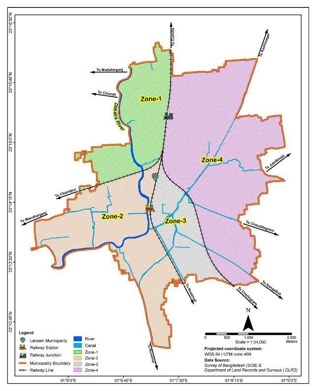
Figure-1: Major Drainage Basins of Laksam Municipality.
Source:Author,2024,basedonLaksam PourashavaMasterPlan(2020-2040)
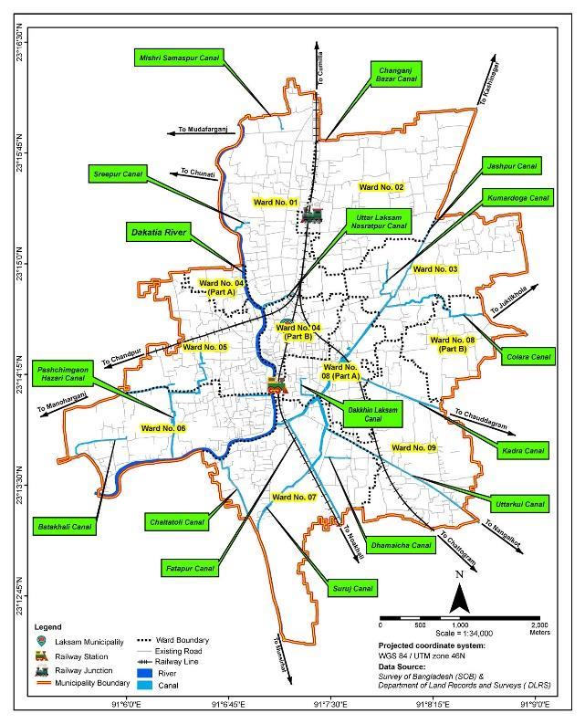
Figure-2: River and Canals in Laksam Municipality.
Source:Author,2024,basedonLaksam PourashavaMasterPlan(2020-2040).
Table-2: Natural Canals and River in the Major Drainage Basins (Length in Km.).
Major Drainage Basin Name of the Natural Canal and River Length Flow Direction
Zone-1: Towards Cumilla (Z1)
DakatiaRiver (part) 3.10 Northto South Mishri Samaspur Canal 0.77 Eastto West
SreepurCanal 0.24 Eastto west
UttarLaksam Nasratpur Canal 0.46 Eastto West
Zone-2: Towards Chandpur and Manoharganj (Z2)
Zone-3: Towards Noakhali and Chattogram (Z3)
DakatiaRiver (part) 4.00 Eastto West ZilaParishad Canal 0.43 Westto East BatakhaliCanal 1.49 Northto South Pashchimgaon HazariCanal 3.50 Northto South SurujCanal 2.51 Southwest to Northeast Chaltatoli Canal 1.10 Southto North
Dakkhin LaksamCanal 0.62 Northto South Dhamaicha Canal 0.33 Eastto West
UttarkulCanal 0.77 Southeast
International Research Journal of Engineering and Technology (IRJET) e-ISSN: 2395-0056
Volume: 11 Issue: 12 | December 2024 www.irjet.net p-ISSN: 2395-0072
Zone-4: Towards Kashinagar (Z4)
(part) to Northwest KadraCanal (part) 0.25 Southto North
UttarkulCanal (part) 1.60 Southeast to Northwest KadraCanal (part) 1.40 Eastto Northwest ColaraCanal 2.21 Eastto West
Kumardoga Canal 0.62 Northto South JashpurCanal 2.79 Northeast to Southwest Changanz BazarCanal 0.17 Eastto West FatahpurCanal 4.49 Southto North
Source:PhysicalFeatureSurvey,2019(MasterPlan,2020).
2.1.1 Existing Watersheds
Watershedregions(Figure-3)arescatteredthroughoutthe LaksamMunicipality.Thethreefeatures–thepond,ditch, andbeelcontributetopartiallypreventfloodinginthearea byretainingrainwaterduringthemonsoon.However,inthe city,542.62acresoflandmakeupthewatershedsoftotal area.
Table -3: Watersheds Areas.
Source:PhysicalFeatureSurvey,2019(MasterPlan,2020).
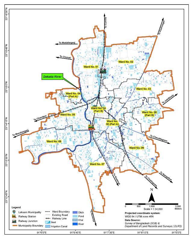
Figure-3: Watersheds of Laksam Municipality
Source:Author,2024,basedonLaksam PourashavaMasterPlan(2020-2040)
StormwaterrunoffoftheMunicipalityisdrainedbynatural opencanalsthroughoutthewatersheds.Mostoftherunoff fromtheurbanizedareas,especiallythecentralpart,covers open drain. Runoff transports through those drains and dischargesintothenearbylow-landsandcanals,atlastin DakatiaRiver(Figure-4).Existingmunicipalstormdrainage systemconfigureswithman-madedrainispresentedinthe Table-4.
Table-4: Man-made Drains.
Source:PhysicalFeatureSurvey,2019(MasterPlan,2020).
International Research Journal of Engineering and Technology (IRJET) e-ISSN: 2395-0056
Volume: 11 Issue: 12 | December 2024 www.irjet.net p-ISSN: 2395-0072
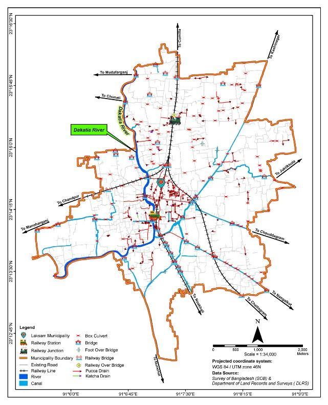
Figure-4: Existing Man-made Drains.
Source:Author,2024,basedonLaksam PourashavaMasterPlan(2020-2040).
To analyze existing as well as potential blue and green networklocations,eachmajorbasinhasfurtherdelineated intosub-basins.Sub-basinareaisthewatershedwithinwhich runoff assumes to flow to a single discharge point. It considers as an area. In the Laksam Municipality, 21 subbasin areas identify in its 4 zones (Table-5). Locations of thosesub-basinsareshownintheFigure-5.
Table-5: Sub-basins according to covered Area and Zone.
Zone
Z1 05 01 02 02
Z2 06 0 04 02
Z3 01 0 0 01
Z4 09 03 03 03
Total 21 04 09 08
Source:PhysicalFeatureSurvey,2019(MasterPlan,2020).
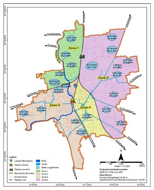
Figure-5: Location of Sub-basins.
Source:Author,2024,basedonLaksam PourashavaMasterPlan(2020-2040).
ThehydrologiccomputermodelHEC-HMS,developedbythe U.S.ArmyCorpsofEngineers,isusedtocalculaterunofffrom eachsub-basin.Tocalculatetheestimatedpeakflowsfrom each sub-basin, this model makes use of the input parameters,basindelineation,andmodelparameters.Peak flows from every sub basin are calculated for frequency eventsthatoccurevery10,25,50,and100years.
2.2.2
Using collected flow monitoring data from four locations distributedacross theMunicipality,aneffortwasmade to CalibrateModelFlowstomeasurevalues.Thegraphsbelow show how the measured peak flows compare to the uncalibratedHEC-HMSmodel.Aperfectcalibrationwould show the highest value (peak) between two observation points equal to the observed Peak Flow. A tabular descriptiononeachfiguresummarizestheresultsbybasin. The HEC-HMS model in the Basin underestimated the greater peak flows but matched well for the lesser rain events.Herearethespecifics.
2.2.3 Basin Flow Calibration
Whencalibratingdatavalueslinkedtorainfall,stormwater, washing,andbathingwater,theHEC-HMSModelprovides guidanceandinfluencestheflowofdatafromuppertolower orderinaccordancewiththecontourline(landlevel).Once more,theparameterthatdisplaystheaveragevalueisthe
International Research Journal of Engineering and Technology (IRJET) e-ISSN: 2395-0056
Volume: 11 Issue: 12 | December 2024 www.irjet.net
time factor. In order to execute the model, the minimal consideration for flow analysis is -1 if there isn't any significantcongestioninthearea.
Here,BulkRainfall+Space+FlowCanal+TimeDuration= Negative or Positive change needed. Moreover, negative averagevaluemeansnodrainagecongestionavailableinthe basinexceptsomeborrow-pitwhererainwaterstandsfora certaintimethatisnotthecongestion.
Zone 1: Towards Cumilla (Z1).
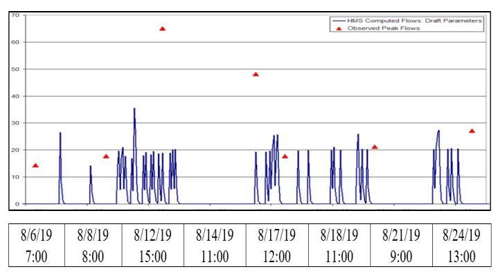
Figure-6: Z1 Basin Flow Calibration.
Source:DDC,2020&MasterPlan,2020,basedonPhysical FeatureSurvey,2019.
Basin/Dancer Outfall, Zone 1.
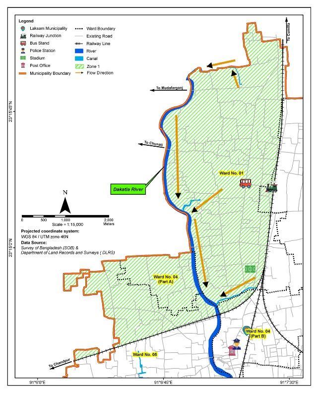
Figure-7: Flow Direction of Zone 1.
Source:Author,2024,basedonLaksam PourashavaMasterPlan(2020-2040).
Zone 2: Towards Chandpur and Manoharganj (Z2).
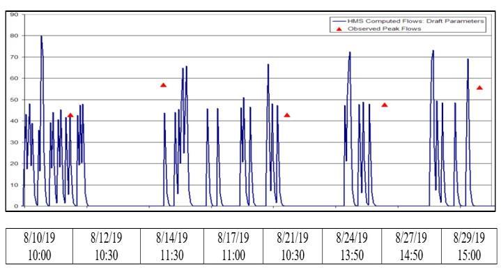
Figure-8: Z2 Basin Flow Calibration.
Source:DDC,2020&MasterPlan,2020,basedon PhysicalFeatureSurvey,2019.
Table-7: Basin/Dancer Outfall, Zone 2.
Source:DDC,2020&MasterPlan,2020,basedonPhysical FeatureSurvey,2019.
International Research Journal of Engineering and Technology (IRJET) e-ISSN: 2395-0056
Volume: 11 Issue: 12 | December 2024 www.irjet.net p-ISSN: 2395-0072
8/27/1914:50
8/29/1915:00
Source:DDC,2020&MasterPlan,2020,basedonPhysical FeatureSurvey,2019.
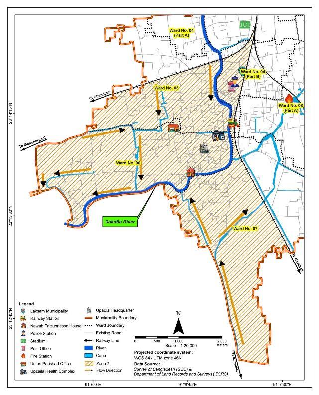
Figure-9: Flow Direction of Zone 2
Source:Author,2024,basedonLaksam PourashavaMasterPlan(2020-2040).
However,ithasobservedthatforZones3and4,thevaluesof measured flow, uncalibrated HEC-HMS flows, and the percentage of flow change required are nearly same. As a result, there has been no separate display of the Z4 Basin FlowCalibration.
Zone 3: Towards Noakhali and Chattogram (Z3).
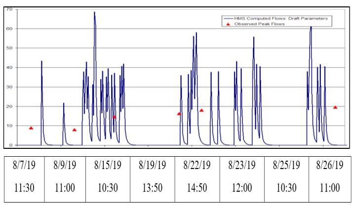
Figure-10: Z3 Basin Flow Calibration.
Table-8: Basin/Dancer Outfall, Zone 3.
Source:DDC,2020&MasterPlan,2020,basedonPhysical FeatureSurvey,2019.
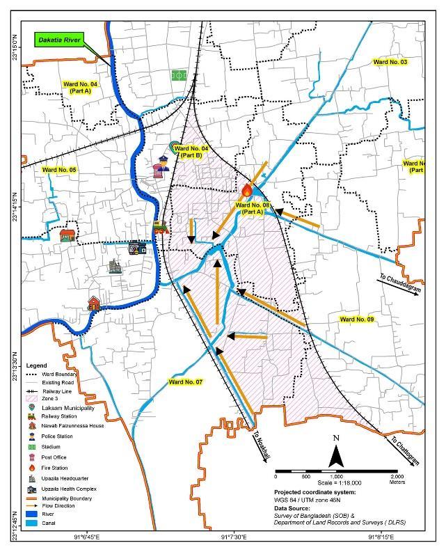
Figure-11: Flow Direction of Zone 3.
Source:Author,2024,basedonLaksam PourashavaMasterPlan(2020-2040).
Table-9: Basin/Dancer Outfall, Zone 4.
Source:DDC,2020&MasterPlan,2020,basedonPhysical FeatureSurvey,2019.
Table-8: Basin/Dancer Outfall, Zone 03.
International Research Journal of Engineering and Technology (IRJET) e-ISSN: 2395-0056
Volume: 11 Issue: 12 | December 2024 www.irjet.net p-ISSN: 2395-0072
Source:DDC,2020&MasterPlan,2020,basedonPhysical FeatureSurvey,2019.
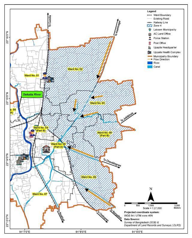
Figure-12: Flow Direction of Zone 4.
Source:Author,2024,basedonLaksam PourashavaMasterPlan(2020-2040).
The author has demonstrated one method of organizing a BGInetworkwithaspecificfocusonaplannedsystemthat offersarangeofoptionsforfloodcontrolandstormwater management,addressingtherealitiesofongoingneglectto themunicipality’sblueandgreenelementsaswellasfuture risksfromclimatechangeanduncontrollablydenseurban growth. This is just one of the many possible ways to implementaBGInetworkinanurbansetting.Consequently, the author has provided strategies for the Laksam Municipalitythatwillenablevariousstakeholderstofollowa conceptualandstructuralframeworkforthemunicipality's futuredevelopment.Hence,MajorDrainageNetworkPlan, Minor Drainage Network Plan and Outfall System are all included in the framework and combinedly these would create morphological patterns which are more consistent with the topography of the current terrain and can also accommodatewaterandindividualsinharmony.
The Laksam Municipality’s natural canals are created naturally, following the ground’s natural slope to drain
surface runoff from different areas of the city without the need for human intervention. From high to low lying locations, the flow shifts. All of the city’s artificial drains empties into the Dakatia River and natural canals. Some canalsfalldirectlyintotheriver,whileothersareconnected to other canals and eventually end up in the river. The DhamaichaandChanganjBazarcanalsaretheonlyonesthat havenooutfallpoint,andthePashchimgaonHazaricanalis disconnected from the Dakatia River because of road encroachment. Thus, in the city’s drainage network, an outfallsystemusuallyconcentratesonawatershedtributary to a large waterway, such as a river. In the municipality, threeoutfallshavebeenidentified(Figure-13),oneofwhich isinZone1andtwoofwhichareinZone2forbothsmooth runoffofsurfacewaterandstormwater.
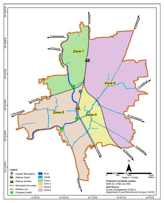
Figure-13: Drainage Outfalls of Laksam Municipality.
Source:Author,2024,basedonLaksam PourashavaMasterPlan(2020-2040).
Laksam Municipality’s well-planned primary drainage network (Figure-14) would protect the urban area from significant property damage, injury and loss of life from flooding. Hydrologic analyses provide the basis of this network(80.59Km)design.Thestudygenerallyfocuseson the main stem of the stream, identifying a floodplain to mitigatethefloodhazard,aswellastoimprovethe safety andfunctionofthestream.
In addition, a benefit-cost analysis has performed for reaching where structures have identified in the 30-year floodplaintoassistinthealternativeselectionprocess.The
International Research Journal of Engineering and Technology (IRJET) e-ISSN: 2395-0056
Volume: 11 Issue: 12 | December 2024 www.irjet.net p-ISSN: 2395-0072
benefithasmainlymeasuredinreducedflood damages to presentstructuresasaresultofrecognizedimprovements, thoughitisimportanttolikewiseidentifyotherintangible (oratleastdifficulttovaluate)benefitsconsistentimproved water quality, removal of street flooding, public safety, aestheticsandrecreation(eitheractiverecreationsuchas organized sports and individual exercise, or passive recreationwhichmaysimplyentailbeingintheopenspace). Timespentinanurbanopenspaceforrecreationoffersthe healthfulbenefitofanaestheticandpsychologicalreprieve fromtheurbanenvironmentofLaksamMunicipality.
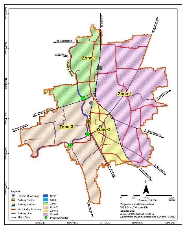
Figure-14: Major Drainage Network Plan.
Source:Author,2024,basedonLaksam PourashavaMasterPlan(2020-2040).
Theminordrainagenetworkplanincludesconveyancessuch as grass swales, streets and gutters, storm drains and roadsideditches,stormdrainpipes,on-sitedetention,and runoff reduction (e.g., minimized directly connected impervious areas). It also comprises conveyance and storage-basedwaterqualityfacilities.Therefore,theinitial drainage system (Figure-15) for Laksam Municipality has properlyplannedanddesignedtoreducecomplaintsfrom the community related to localize flooding and drainage nuisanceconditions.Moreover,awell-organizedpreliminary drainage(218.27Km)arrangementofthecitywouldprovide for convenient drainage, reduces costs of streets and minimizesdisruptionstothefunctionofurbanareasduring runoffevents.
Fortheareaservedbyman-madedrain,theoriginalstorm hasdefinedtohaveareturnfrequencyofonceevery2to10
years. Furthermore, during the minor drainage network plan, it has been focused that the drainage system would drainatributarynotlargerthan20acres,astherunofffrom thatareawouldbeinexcessofthetypicalcapacityofthose features within a street section. In addition, the initial systemexistswithorwithoutstormdrains.Besides,storm drainsareneededwhentheotherpartsoftheinitialsystem no longer have capacity for additional runoff. However, a good major drainage system coupled with wise layout of streets can often significantly reduce the need for storm drains.
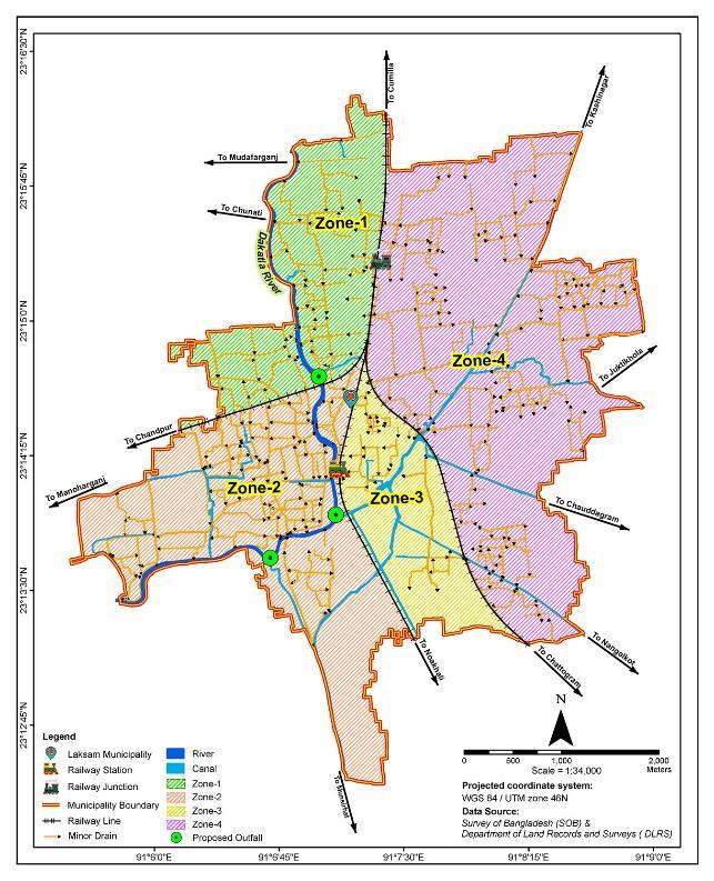
Figure-15: Minor Drainage Network Plan.
Source:Author,2024,basedonLaksam PourashavaMasterPlan(2020-2040).
A metropolitan area’s drainage network is an essential componentofitswell-functioningsystem.Besides,without an adequate transportation and drainage arrangement, urban life suffers. An integral aspect of urban living is the drainagenetwork,bothnaturalandman-made.Therivers, canals,andirrigationcanalsthatcompriseamunicipality’s naturaldrainagenetwork.Hence,settingprioritiesbasedon each individual’s drainage value is crucial for creating an appropriate,long-term,water-sustainableurbanplan.
In order to develop a water-sustainable urban form for Laksam Municipality, a framework for designing and executingtheBGInetworkhasbeenprovidedinthisstudy. Themunicipality’splannednetwork,whichoffersavariety ofoptionsforstormwatermanagementandfloodcontrol,is addressed by the proposed BGI network. This network considers the risks associated with uncontrolled urban
International Research Journal of Engineering and Technology (IRJET) e-ISSN: 2395-0056
growthandclimatechange,aswellastheongoingneglectof thecity'sgreenandblueelements.Thebenefitsofadoptinga BGInetworkwithinthecurrentframeworkofalocalurban organizationinBangladeshhavealsobeenconferredinthe article, including social, geographical, environmental, financial,andgovernanceaspects.
However,theimplementationofaBlueGreenInfrastructure (BGI)networkinthird-worldurbancontextsrequirescareful considerationduetothesocio-culturaldynamicsandslow pace of development. To overcome challenges, a better understandingofthesynergies,trade-offs,andcapacityof existingblueandgreenspacesareneeded.Non-regulatory interventions, such as education, are needed to raise awarenessaboutBGI’sbenefitsinpersonalandpubliclife. Additionally, participatory planning and creative flood management experiments can also help avoid top-down, technology-heavy,andlarge-scaleinfrastructuralsolutions.
Forhistechnicalguidanceandfacilitiesduringtheresearch, the author is grateful to Mr. Nessar Uddin Ahmed, Individual Consultant as Urban Planner and GIS Expert, Dhaka,Bangladesh.
1 Saha, P.K. 2017. “Building water-sustainable city”, The Financial Express, published: November 29, 2017, https://thefinancialexpress.com.bd/views/buildingwater-sustainable-city-1511966459, retrieved on 12 August2022.
2 Ahmed,S.,Meenar,M.,Alam,A.2019.‘DesigningaBlueGreen Infrastructure (BGI) Network: Toward WaterSensitiveUrbanGrowthPlanninginDhaka,Bangladesh’, Land 2019, vol. 8(9), pp. 138-158, http://resolver.tudelft.nl/uuid:77d360b2-d4d5-4a1b8273-b4ddbc13bf3c, doi: https://doi.org/10.3390/ land8090138,retrievedon26November2023.
3 Wouters, P., Dreiseitl, H., Wanschura, B., Worlen, M., Moldaschl, M., Wescoat, J., Noiva, K. 2015. ‘Blue-Green infrastructures as tools for the management of urban developmentandtheeffectsofclimatechange’, Thefull reporttitled“StrengtheningBlue-GreenInfrastructurein ourCities-EnhancingBlue-Greeninfrastructure&social performance in high density urban environments”, coordinated by Ramboll’s Liveable Cities Lab, https://static1.squarespace.com/static/5b008764710699 f45ff1e509/t/5d1228e609ef9500018e5c5/15614712766 47/BlueGreen+Infrastructure_LCLcompressed_compresse d+%281%29.pdf,retrievedon28November2022.
4 Master Plan. 2020. ‘Laksam Pourashava Master Plan: 2020-2040’, Local Government Engineering Division,
Ministry of Local Government, Rural Development & Cooperatives, Government of the People’s Republic of Bangladesh.
5 Brown,R.R.,Keath,N.,&Wong,T.H.2009.‘Urbanwater management in cities: historical, current and future regimes’, Water Science and Technology, vol. 59(5), pp. 847–855, doi: https://doi.org/10.2166/wst.2009.029, retrievedon15October2023.
6.Ellis,J.B.,andLundy,L.2016.‘Implementingsustainable drainage systems for urban surface water management withintheregulatoryframeworkinEnglandandWales’, Journal of environmental management, vol.183(3), pp. 630–636,doi:https://doi.org/10.1016/j.jenvman.2016. 09.022,retrievedon12December2023.
7 Meenar, M.R. 2019. ‘Integrating place making concepts intoGreenStormwaterInfrastructuredesignintheCityof Philadelphia’, Journal of Environmental Practice, vol.21, pp.4–19,doi:https://doi.org/10.1080/14660466.2019. 1568121,retrievedon16January2024.
8 Chan,F.K.S.,Griffiths,J.A.,Higgitt,D.,Xu,S.,Zhu,F.,Tang, Y.-T.,Xu,Y.,Thorne,C.R.2018.“SpongeCity”inChina–A BreakthroughofPlanningandFloodRiskManagementin theUrbanContext, Land Use Policy 2018,vol.76,pp.772778,https://doi.org/10.1016/j.landusepol.2018.03.005, retrievedon22September2023.
9 Wella-Hewage,C.S.,AlankarageHewa,G.,&Pezzaniti,D. 2016.‘Canwatersensitiveurbandesignsystemshelpto preserve natural channel-forming flow regimes in an urbanizedcatchment?’, WaterScienceandTechnology,vol. 73(1), 78–87, PMID: 26744937, doi: 10.2166/wst.2015.464,retrievedon11October2023.
10.Frischenbruder,M.T.M.,andPellegrino,P.2006.‘Using greenways to reclaim nature in Brazilian cities’, Landscape and Urban Planning,vol.76(1-4),pp.67-78, https://www.researchgate.net/publication/223766884_ Using_greenways_to_reclaim_nature_in_Brazilian_cities, doi:10.1016/j.landurbplan.2004.09.043,retrievedon23 October2022.
11. Silva, J.M.C.d., and Wheeler, E. 2017. ‘Ecosystems as infrastructure’, PerspectivesinEcology and Conservation, vol. 15(1), pp. 32-35, https://www.researchgate.net/ publication/316079159_Ecosystems_as_infrastructure, doi:10.1016/j.pecon.2016.11.005,retrievedon25June 2022.
12. Haase, D. 2015. ‘Reflections about blue ecosystem services in cities’, Sustainability of Water Quality and Ecology, vol. 5, pp. 77–83, https://www.semanticscholar.org/paper/Reflectionsabout-blue-ecosystem-services-in-cities-Haase/f1d7ba
Volume: 11 Issue: 12 | December 2024 www.irjet.net p-ISSN: 2395-0072 © 2024, IRJET | Impact Factor value: 8.315 | ISO 9001:2008
| Page
International Research Journal of Engineering and Technology (IRJET) e-ISSN: 2395-0056
Volume: 11 Issue: 12 | December 2024 www.irjet.net p-ISSN: 2395-0072
5d39a0573c1375e1cf052e3522c020d6e9, doi:10.1016/J.SWAQE.2015.02.003, retrieved on 12 August2023.
13. Lennon, M.; Scott, M.; Collier, M.; Foley, K. 2017. ‘The emergence of green infrastructure as promoting the centralization of a landscape perspective in spatial planning:thecaseofIreland’, Landscape Research,vol. 42(2), pp. 146-163, http://www.tara.tcd.ie/handle/2262/86134, doi: https://doi.org/10.1080/01426397.2016.1229460, retrievedon26January2023.
14.Hoyer,J.,Dickhaut,D.,Kronawitter,L.,&Weber,B.2011. “Water Sensitive Urban Design: Principles and InspirationforSustainableStormwaterManagementin the City of the Future”, JOVIS: Berlin, Germany, 2011, ISBN 978-3-86859-106-4, https://www.ircwash.org/resources/water-sensitiveurban-design-principles-and-inspiration-sustainablestormwater-management, retrieved on 12 February 2023.
15. O’Donnell, E.C., Lamond, J.E., & Thorne, C.R. 2017. ‘RecognizingbarrierstoimplementationofBlue-Green Infrastructure: A Newcastle case study’, Urban Water Journal, vol. 14(9), pp. 964–971, https://uwerepository.worktribe.com/output/902961/recognisingbarriers-to-implementation-of-blue-greeninfrastructure-a-newcastle-case-study, doi: https://doi.org/10.1080/1573062 X.2017.1279190, retrievedon11October2022.
16. Lawson, E., Thorne, C., Ahilan, S., Allen, D., Arthur, S., Everett,G., Fenner,R., Glenis,V.,Guan,D.,&Hoang,L. 2017.‘Deliveringandevaluatingthemultiplefloodrisk benefits in blue-green cities: An interdisciplinary approach’, WIT Transactions on Ecology and the Environment, vol. 184, pp.113–124, https://www.witpress.com/elibrary/wit-transactionson-ecology-and-the-environment/184/28342, doi:10.2495/FRIAR140101, retrieved on 12 August 2022.
17. Ghofrani, Z., Sposito, V., & Faggian, R. A. 2017. ‘Comprehensive Review of Blue-Green Infrastructure Concepts’, International Journal of Environment and Sustainability (IJES), vol. 6, pp.15–36, doi:10.24102/ijes.v6i1.728,retrievedon28November 2022.
18.Kruuse,A.2011.‘Thegreenspacefactorandthegreen points system’, Grabs Expert Paper 6, TCPA, PERFECT project.
19. Bogunovich, D. 2012. ‘Urban sustainability: Resilient regions, sustainable sprawl and green infrastructure’,
2024, IRJET | Impact Factor value: 8.315 |
The 7th International Conference on Urban Regeneration and Sustainability, 7 - 9 May 2012, Ancona,Italy,PostConferenceReport,SustainableCity VII, vol. 155, pp. 3-10, https://www.wessex.ac.uk/conferences/2012/sustaina ble-city-2012,doi:10.2495/SC120011,retrievedon26 August2022.
20. Ghofrani, Z., Sposito, V. & Faggian, R. 2016. ‘Designing resilientregionsbyapplyingblue-greeninfrastructure concepts’, WIT Transactions on Ecology and The Environment, vol 204, pp. 493–505, https://www.witpress.com/Secure/elibrary/papers/SC 16/SC16042FU1.pdf,doi:10.2495/SC160421,retrieved on21November2022.
21. Everett, G., Lamond, J., & Lawson, E. 2015. Green infrastructure and urban water management, In Handbook on Green Infrastructure: Planning, Design and Implementation; Edward Elgar: Gloucester, UK, 2015; pp. 50–66, ISBN: 978 1 78347 399 1, doi:10.4337/9781783474004,retrievedon22January 2023.
22.Fletcher,T.D.,Shuster,W.,Hunt,W.F.,Ashley,R.,Butler, D., Arthur,S.,Trowsdale,S.,Barraud,S.,Semadeni-Davies, A.,Bertrand-Krajewski,J-L.,Mikkelsen,P.S.,Rivard,G., Uhl,M.,Dagenais,D.,& Viklander,M.2015.‘SUDS,LID, BMPs,WSUDandmore-Theevolutionandapplicationof terminologysurroundingurbandrainage’, Urban Water Journal, vol. 12(7), pp. 525-542. https://doi.org/10.1080/1573062x.2014.916314, retrievedon29September2023.
23. Liao, K.H., Deng, S., & Tan, P.Y. 2017. Blue-green infrastructure: New frontier for sustainable urban stormwater management.InGreeningCities,Springer: Berlin, Germany, pp. 203–226, doi:10.1007/978-98110-4113-6_10,retrievedon17August2023.
24.Cruijsen,A.2015.‘Designopportunitiesforflashflood reduction by improving the quality of the living environment: A Hoboken City case study of environmental driven urban water management’ unpublishedMasterthesis,TUDelft,DelftUniversityof Technology, the Netherlands, https://repository.tudelft.nl/islandora/object/uuid%3A f433a5ce-8249-4976-a43f-a741b4ce2bf9,retrievedon 21September2023.
25. Hansen, R., Olafsson, A.S., van der Jagt, A., Rall, E., & Pauleit, S. 2019. ‘Planning multifunctional green infrastructure for compact cities: What is the state of practice?’, Ecological Indicators, vol. 96, pp. 99-110, https://www.sciencedirect.com/science/article/abs/pii/ S1470160X17306106?via%3Dihub,
International Research Journal of Engineering and Technology (IRJET) e-ISSN: 2395-0056
Volume: 11 Issue: 12 | December 2024 www.irjet.net p-ISSN: 2395-0072
doi:10.1016/j.ecolind.2017.09.042, retrieved on 12 December2022.

Mohammed Saiful Islam is a Town Planner of Local GovernmentDivisionoftheMinistryofLocalGovernment, RuralDevelopmentandCooperativesofGovernmentofthe People’sRepublicofBangladesh.Hehasbeenworkinginthe urban development sector from last eighteen years. Moreover, he has a number of researches works (three journals,twobookchapters,sevenarticles,oneregionaland six international proceeding papers) relevant to urban problems and solutions as well. His fields of Interest comprise Inclusive, Smart and Sustainable Urban Development; Sustainable Urban Drainage System, SustainableTourismPlanning;andClimateResilientDisaster RiskManagement.Inaddition,heparticipatedintheseveral international trainings and workshops in abroad as a participant as well as a resource person. He is also an alumnusoftheUNITARCifalJeju,RepublicofKorea;Center forLiveableCities,SingaporeCooperationProgramme(SCP); andAcademia.edu.