
KEJIE WANG Selected Works 2017-2022 wkejie@umich.edu | 734-450-8742

wkejie@umich.edu 734-450-8742
12/2022 (Expected) Master of Urban Design, University of Michigan, MI
06/2019
Bachelor of Urban Planning, Southwest Jiaotong University, CHINA
07/2020 - 01/2021
Intern
AECOM, Master Plan Department Harbin Urban Design International Competition: Provide multiple conceptual propos als for comparison during the brainstorm stage. Assistance in designing the massing and flow lines of the riverfront area. Making physical and digital model, drawing dia grams, renderings and arranging documents during the production phase. Jiaxing High-Speed Rail Station Urban Design: Assistance in designing master plan, transportation plan and building second floating corridor during SD phase. Making digital model and drawing diagrams during the production phase.
09/2018 - 02/2019 Guizhou Architecture Research & Design Institute, RZW Architecture Studio Shiyan Middle School Building Design: Designing the building facade. Laying out the column network in the CD phase. Making model, drawing CAD and renderings. Fengyu School Gymnasium Design: Designing the function distribution of the build ing and the surrounding landscape. Making model and drawing diagrams.
Intern
Certificate
LEED® AP BD+C U.S. Green Building Council
Credential ID: 11499139-AP-BD+C
LEED® AP ND U.S. Green Building Council
Credential ID: 11499139-AP-ND
Python Data Structure University of Michigan | Coursera
Credential ID: SQNDG4292C2K
Software Modeling: Rhino+Grasshopper/Sketch Up/Auto CAD/Auto Revit Adobe Suite: Photoshop/Illustrator/InDesign/Premier/AfterEffect/Audition/Acrobat Render: Vray/Enscape/Lumion/Blender Analysis: Geographic Information System Microsoft Office: PowerPoint/Word/Excel
Language English(Full professional proficiency) Chinese(Native proficiency)
Other Public Speaking/Architecture Photography/Music Performance
04/2022
Selected Architecture Student Show Team work: River Respirator (Investigation,Design,Data Analysis,Modeling,Drawing) Organizer: Taubman College, University of Michigan
06/2022 Acts of Urbanism Volunteer: Experimental Performing Arts and Design Festival in Detroit Organizer: Taubman College, University of Michigan
06/2019 Student Work Exhibition of Eight Universities in Southwest China Team work: Urban Anchor (Design,Modeling,Drawing) Organizer: Southwest Jiaotong University

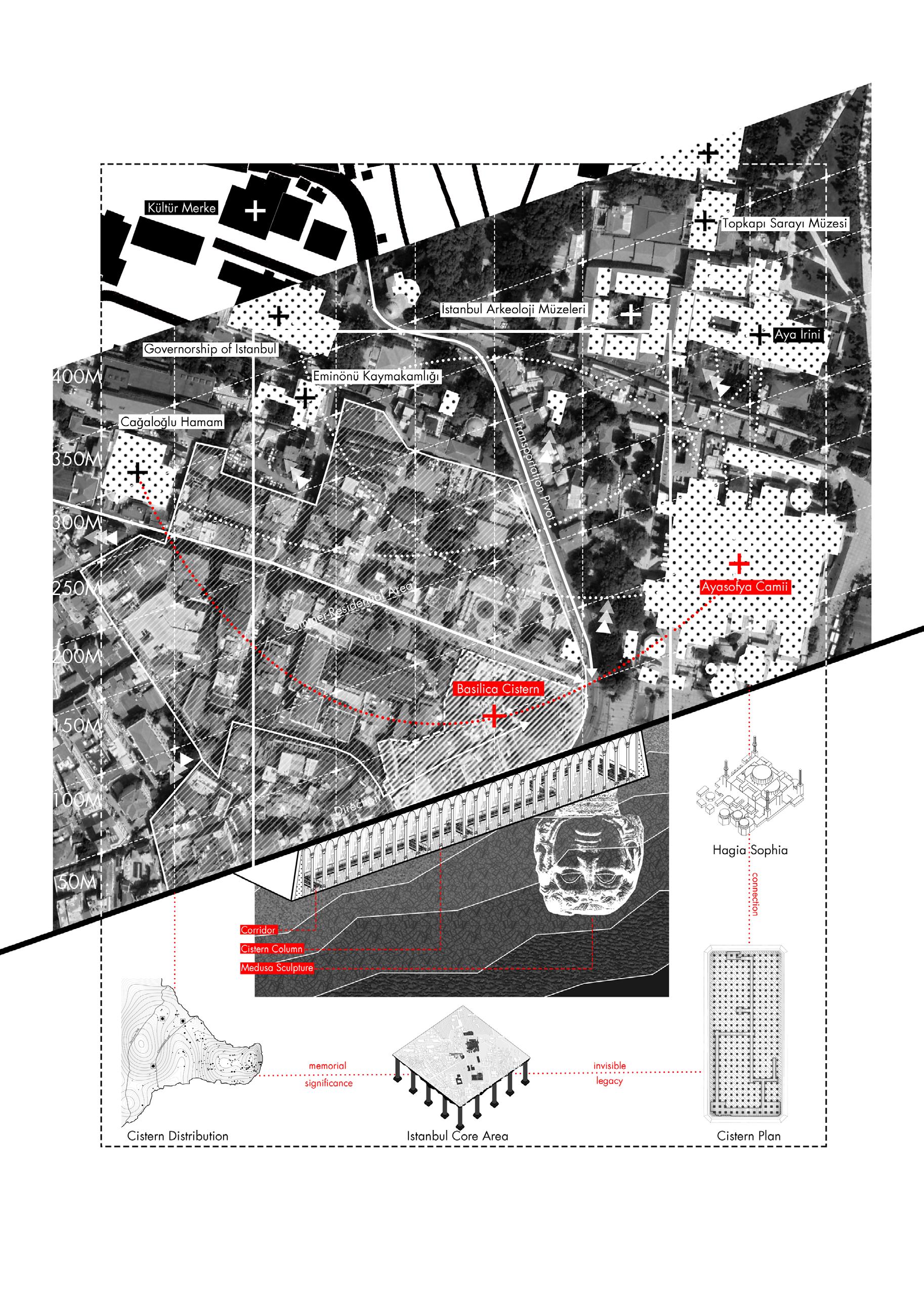
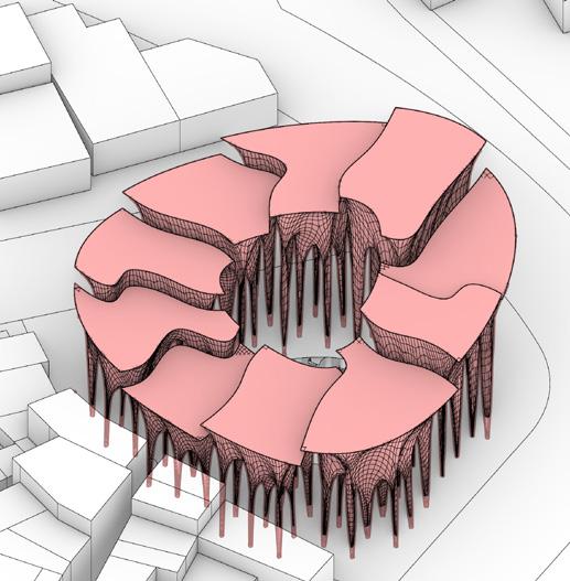
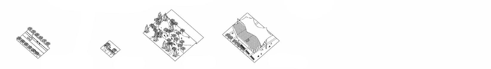
Istanbul Water Common Instructor: El Hadi Jaizary Site: Istanbul, Turkey University of Michigan, UD732 Design Studio Time: December, 2022
This Project focuses on the legacy preservation, urban renovation and water infrastructure. This totally organic structure, I call it the mountain, is the exper imental preservation of the traditional basilica cistern. In this project I want to discuss what will happen when the high-tech organic structure plugs into the traditional low-tech one. How this contrast impacts the community and the city.
Here is the story begin. From the whole cistern distribution in the great istan bul area to the very core area, the basilica cistern. I find all of the cistern is invisible to the public and functional abandoned. They once saved the city, but now they are forgotten. So I want to reveal the cistern, reuse the infrastructure and renovate the community by the design. I chose the basilica cistern as my site, which is the most important cistern and located in the most significant cultural area of istanbul because of the hagia sophia. The com munity is mixed-use maily is hotel and commercial. I think this area is full of potential to do something radical. To connect the community and the legacy, the cistern and the hagia sophia.
_Location _Cultural relationship _Neighborhood condition _Basilica cistern detail


Focused on Water Purification, Inhabitant, Ecology
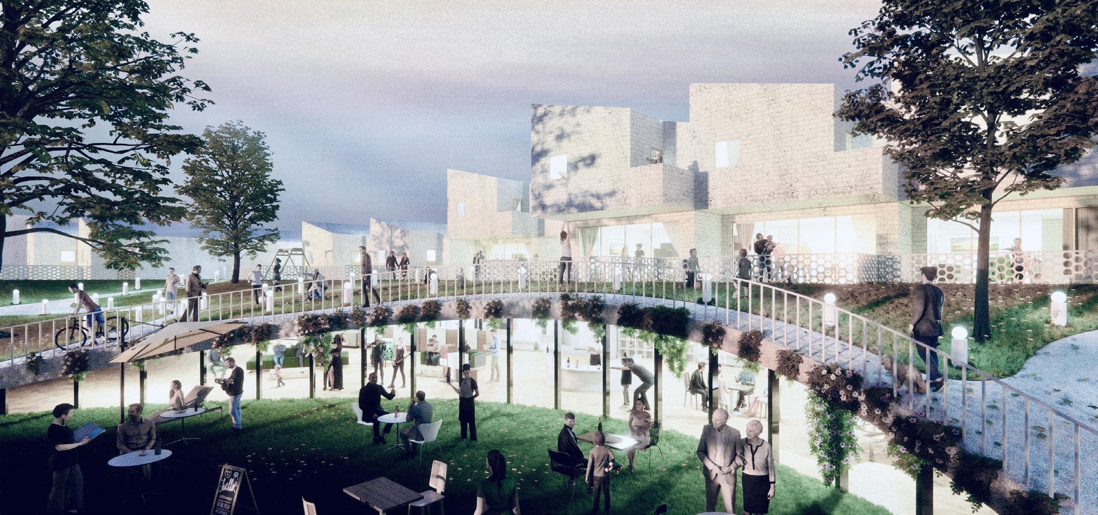
Detroit & the Dis-Aggregated Riverfront Urban Design Instructor: María Arquero de Alarcón/Claudia Wigger Site: Detroit River, Detroit University of Michigan, UD722/ARCH562 Design Studio Time: April, 2022
“Breathing is the process of moving air into and from the lungs to facilitate gas exchange with the internal environment, mostly to flush out carbon diox ide and bring in oxygen.”
Human and non-human beings need to breathe. Nature breathes, and every factory and home also breathes as part of the urban metabolism. And you think for a second how long it’s been since you’ve breathed last? We may wonder why we ought to let our cities and rivers, mountains and seas, breathe... You may think it is to save the planet, but what is the planet other than ourselves?
The Detroit River is a global infrastructure of transportation and industrial production, and its waters have been reengineered over and over again to hold their breath and behave according to the script of economic progress. Clean air, soil, and water have become increasingly rare and inaccessible, and the presence of life in the river has for long been a concern.
“DETROIT RIVER CANNOT BREATHE !!!”
But what if the river were to breathe once again? Would that disrupt our en gagement with it? How can we reimagine, as we inhale, a different future for the Detroit River.


Detroit & the Dis-Aggregated Riverfront Urban Design Instructor: Mclaine Clutter/Gina Reichert Site: Uniroyal Site, Detroit University of Michigan, UD712 Design Studio Time: December, 2021
As I investigated the Uniroyal site and the wider riverfront, themes of frag ment and continuity emerged alongside systems of access, ownership, and activity. So, in response, I am placing value on the vector, the enclave, and the moment as methods of design. Urban vectors travel between enclaves in search of moments. THIS PROJECT VALUES THE MOMENT. This project is interested in both enclaves and commons, and how they might be simultane ously stitched together and sharpened in distinction. That access is a relative term, and the commons consists of dynamic thresholds of open and closed networks of exchange.
RIVERWALK ( existing)


RIVERWALK ( under const.) ROAD PARK WATER BODIES
UNIROYAL SITE
ATTRACTIONS (existing)
ATTRACTIONS (demolished)
post-industrial polluted intersected bounded blocked linked
DRIVER
RIDER WALKER
major entry points linkage biking paths green parks parking


a survey of surroundin spatial types, further organized into a series of vector-stops which are then recombined on the site according to each vector identity

VECTOR_DRIVER: Spatial network of adjacency and access routes[medium to large motor vehicles]
VECTOR_RIDER: Spatial network of adjacency and access routes[small cycles, scooters, skates]
VECTOR_WALKER: Spatial network of adjacency and access routes [individuals and groups on foot]


How do the vectors play out in a recombined streetscape of fragment, continuity, enclave and open space ?


Overview of connective and disruptive elements informewd by + in conversation with each vector
CURVE hub cultural square
beltline green water activity centre

riverwalk
water taxi dock
bike park exploration island
central street

enclave cannal
Richard Park gathering
BRT station platform
elevated bike
Hover theatre
collection courtyard waterfront plaza
A velocity-driven sequence of multilevel platforms, cantilevered bodies, and multi-scalar moments.

[A] Incubator
[B] Frontage
[C] Elevated rideway
[D] Puncture pier
A vector-driven (pun intended) collection of nonlinear flows, tethered spatial types, and diverse moments of individuality and overlap.
[A] Mixed use spatial types
[B] Unspecified spatial types
[C] Studied spatial types

 Water Taxi Dock Riverfront Platform


Focused on TOD Mode, City Split, Public space
Urban Integration Design Instructor: Changquan He Site: Chengdu, China Southwest Jiaotong University, Graduation Design Time: May, 2019
This design is an integrated urban design around the interchange subway station based on the TOD (Transit-oriented development) principle which is characterized by a mixed development model that integrates land for busi ness, education, culture, and residence. Due to the internal construction and facilities of the base are very old, it was decided to demolish and rebuild it to form a new commercial center. I designed its functional distribution in de tail and focused on the underground space and landmark building. Connect urban buildings and subway stations with underground space and a over pass corridor. Finally form a multi-functional business center that can meet the needs of various professional groups.


The site is located in Chengdu, Sichuan Province, China, with a subway inter change station, which is the second larg est transportation hub in Chengdu. Metro line 2 is on the ground and metro line 6 is under the ground. The huge station hall split the city, impede communication be tween residents on both sides and reduce urban commute efficiency.


Because the area of the site is all dilapidated residential and commercial streets, the huge flow of people brought by the metro station has not been efficiently used, and the roads inside the site are irregular and the road utilization rate is low. So I decide to demolish it all for reconstruction.
TOD (Transit-oriented development) mode, that is, public transport-oriented development, is a planning method that maximizes the use of public transportation when planning a commercial or residen tial area. It is characterized by a mixed development model that integrates land for business, education, culture, and resi dence.
Expand the station, standardize the flow of people
Pedestrian overpass connect surrounding area


DEVELOPING MODE ANALYSIS

Further divide the plot to form small-scale blocks Placement of scattered tower building


The reconstructed underground space forms a multi-level public space, connecting separate space in three-dimensional perspective. It integrates line 6 station space, line 2 station space, high line station space, open sunken square, circular gallery walking system and active commercial space as a whole system.

One of the keys of TOD model is highly integrated of transportation, in our program, we attach great importance to the traffic design and study seriously about the underground space. Consequently, render underground transportation system, ground transportation and overhead transportation system form a dimensional organized transportation space.
Sunken Square Underground Traffic Rail Station
Overhead Walking

The core landmark design is exactly a highly functional complex building, which consists of underground commerce directly open to sunken square and line 6 station, continuous and open first floor space, seamless internal and external station space, buffer core combined with business, comprehensive multi-level commercial space, view space, office space, ca tering space and leisure space.
Moreover, the core landmark with its relatively huge volume and overhead corridor system makes it prominent in other building, with distinctive landmark characteristics, becoming a appealing landmark of Xipu station.


Focused on Cost, Construction Detail, Building Design
High Performance Building Design
Instructor: Lars Junghans Site: Toronto, Canada University of Michigan, Arch 505 Elective Time: May, 2022
This project is a practical small residential community. I wanted to break away from the traditional community grouping and create an emerging new residential community with semi-privacy and semi-openness. I raised the interior of the cluster to the second floor to create a common activity area connected to a semi-private courtyard, with a common lounge on the first floor. Users access the garage on the first floor of the building directly from the street outside. We calculated LCC, LCA COST, EMBODIED ENERGY and INITIAL COST data to determine material, structural, energy supply and other issues to achieve sustainable development.


Focused on Minimal Surface, Geometry Modeling, Grasshopper
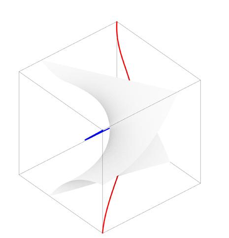
Computational Geometry Instructor: Mania Site: N/A University of Michigan, Arch 709 Advanced Computational Geometry Time: September, 2022
A minimal surface is a surface that is locally area-minimizing, that is, a small piece has the smallest possible area for a surface spanning the boundary of that piece. Soap films are minimal surfaces. Minimal surfaces necessarily have zero mean curvature, i.e. the sum of the principal curvatures at each point is zero. Particularly fascinating are minimal surfaces that have a crys talline structure, in the sense of repeating themselves in three dimensions, in other words being triply periodic.
This project focuses on the computational geometry modeling and minimal surface generation including physical method and mathematical method. In addition also training the mesh operation and physical simulation in Grass hopper by two plug-in namely Kangaroo and WeaverBird.
SCHWARZ’ P SURFACEThe fundamental region, as bound ed by mirror planes, is a quadri lateral in a tetrahedron which is 1/48 of a cube. The left two im ages show the fundamental region before and after evolution. The third image is one cubical unit cell, and the fourth is four unit cells. The fundamental quadrilateral has a C2 axis (straight line with 180 degree rotation symmetry), and the fifth image shows all the embedded C2 axes.
 SCHOEN’S GYROID SURFACE
The gyroid has three-fold rotational symmetry but no embedded straight lines or mirror symmetries. It is lo cally isometric to both the P and D surfaces, being an intermediate in the Bonnet rotation family of the P and D surfaces


Focused on Parametric Design, Skyscraper, Typology
Parametric Skyscraper Design
Instructor: Mark Meier
Site: New York
University of Michigan, Arch 421 Geometry Modeling Time: October, 2022
This project focus on the parametric design using grasshopper and rhino. Within Parametric methodology, classic Geometric Shapes drop leadership for its obduracy and difficulty to adapt to different problems and are re placed for more intuitive, adjustable and institutional solutions. Therefore, we can say that the Parameterization has its own rules, methods and features, rejecting static or rigid solutions, taking into account the variables as lively, dynamic and mutable elements of the design system, linked to the constant needs of adaptation of urban design project. In a parametric design project, geometries are created to be strongly related with all other design elements, where a specific variation will lead to a consequently adaptation response in the model, creating a very dynamic and interactive architectural solution, interconnected and related to all variables of the construction system; each active variable changes, through the system variations and the current model generates changes in the architecture proposal, without losing the consisten cy and integrity of the previous model.


Focused on Memorial, Emotion, Empathy
Water Memorial Design
Instructor: Da Chen Site: Chernobyl, Ukraine SA Open Competition: Reborn In Water Time: December, 2017
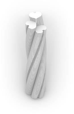
The sarcophagus, the Chernobyl nuclear power plant, has suffered the worst disaster in the history of humankind. Now it has become a tourist attraction, and more and more people come here. However, more people choose to come and play. They laugh, take pictures, show off on social media, and present no sadness or memory. This is the scar of this planet, and we should mourn it with pain. So the purpose of this design is to give people a sense of depression and pain. Inspired by the prototype of the nuclear power plant, designed by water, container, reactors and other elements, trying to evoke people’s immersion and empathy. Through a series of light, shadow, water and space changes, people’s emotions gradually become lower. Finally, they saw the Chernobyl nuclear power plant in a large transparent sarcophagus, and the emotion of mourning was driven to the highest point.


This underground floor plan with a directed streamline guide people to witness the Chernobyl nuclear reactor, the Sarcophagus across the strait.
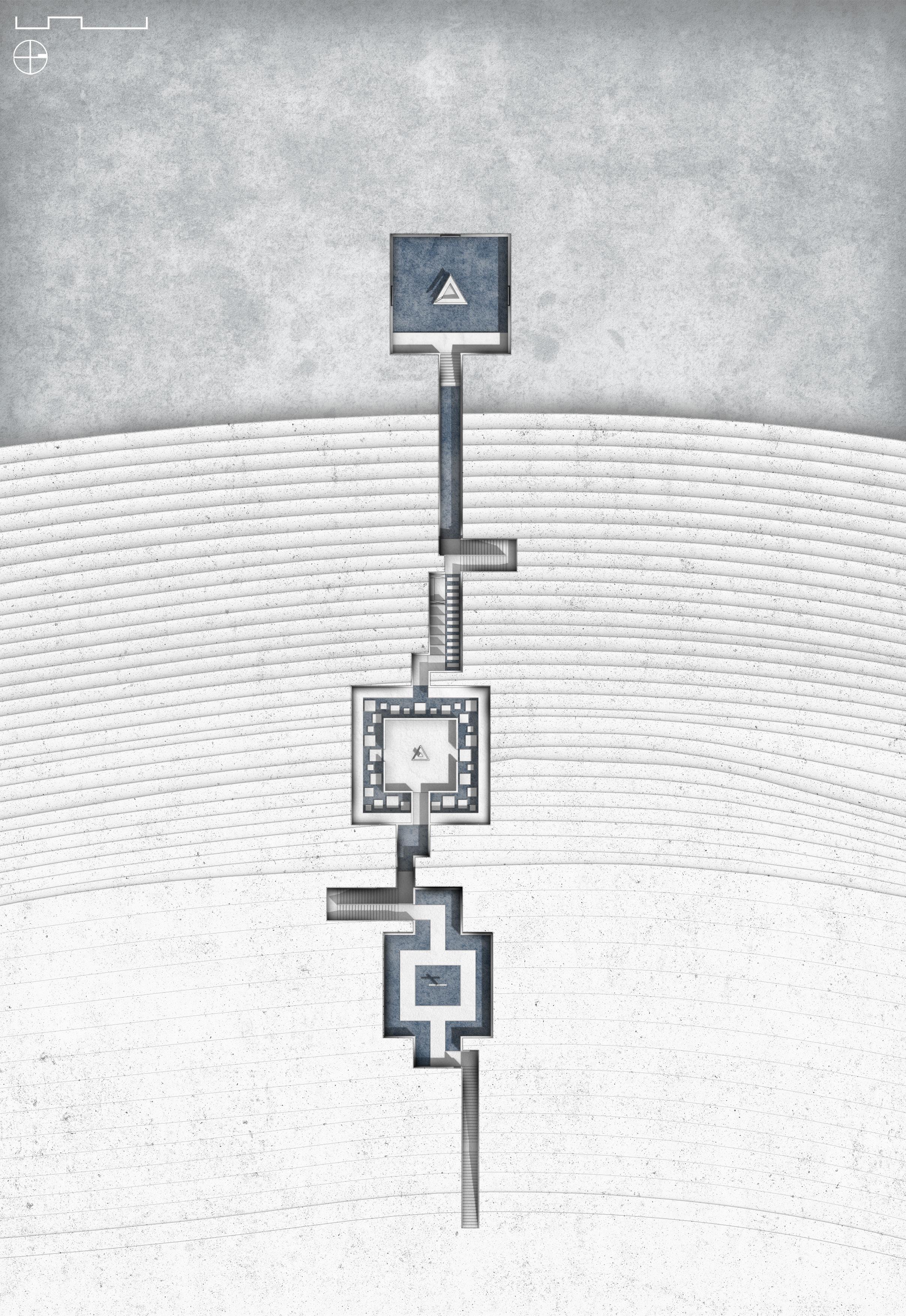
Pray Room 1 Transition Lobby 2
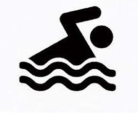
Nuclear Reactor Model 3 Exhibition Corridor 4 Dressing Room & Shower 5 Swimming Corridor 6 Monumental Room 7
Cross Groove Roof

Skylight Dormer Glass Bath Box Bath House & View
Entrance Pray Room Transition Lobby Nuclear Reactor Model Exhibition Corridor Dressing Room Swimming Corridor Monumental Room Spiral


 Pray Room Transition Lobby Nuclear Reactor Exhibition Corridor


 Dressing Storage Swimming Corridor Memorial Room View of Chernobyl