

Dedication
This book is dedicated to my Parents Mrs. Vaishali Shah, Mr. Mukesh Shah and my sister Ms.Rashi Shah who has always encourage and supoorted me to do better. Special thanks to all my MS.ARCH colleagues who have helped me theorize my work efficiently.
A very special thanks to my Prof. Alessandro Orsini for introducing Urban Voids to me. He has always believed in me and my work, has always pushed me beyond my limits and help me develop research questions that I never thought I would. This book would not be possible without him.
SHAPE OF WATER
by Isha Shah© May 2023 Isha Shah
Proseminar:988:01: Culminating Research Project Prof. Alessandro Orsini
A thesis submitted in partial fulfillment of the requirements for the degree of Master of Science, Architecture
School of Architecture
Pratt Institute
April 2023
Aurora borealis III [Abstract N° 1657] Painting

A Painting byKoen Lybaert Belgium
on Canvas
Glossary
Urban Voids
Chapters
Human as an Urban Artifacts.01
The Edge.02
Governor’s Island as an Urban Artifact.03
Emerging Manhattan.04
Conclusion
Studio Project
Bibliography
Image References & Diagrams
viii- xv
xviii - xxv xxviii-xxxvi
xl - xlvii
l - lvii
lx -lxxi
lxx11 - lxxvi
lxxviii - xci
xcii - civ
cvi - cix
Shape Of Water
Glossary Shape
A shape is an outer form of something or someone. Shape in a macro context can be determined by geographical and territorial division of space, water, air, land, or any surface. The shape of something in its noun form can be derived from many factors but the most important is history.1 Shape in its verb form can also be derived from the quality of space, object, body, or purpose. Form
Generally, the shape is associated with two-dimensional space, surface, and form are considered three-dimensional because the form is pulled from any one side of the shape to make it into something that is used to hold something. In a way, to cater to something. Hence, the shape of the water turns into a form so that it can be used. Water
Water is one of the natural resources used for consumption and
1 “Shape Definition & Meaning - Merriam-Webster.” Accessed March 30, 2023. https://www.merriam-webster.com/ dictionary/shape.
recreation. Water in its true form is a colorless, transparent odorless fluid that forms the seas lakes, rivers, and rain which is the basis of the life of living organisms.2 Water can change its form from a solid state to a liquid state to a gaseous state. Hence, with every different role, water is the regulator.
Land
The solid part of the surface of the earth is called land.3 Land in one piece has been one. It was split into continents because of the shift in the tectonic plate due to volcanoes.4 In those gaps, water allowed itself to take space because of its fluid nature and that’s how it gained its shape.
Void
Voids in architecture are perceived to be filled by some spatial function, and the needs of the space around it. They can be negative as well as positive. Voids are not necessarily and always fractured or damaged. Spatial Voids tempt us to fix them. Voids in their natural true form can just be the surface of the land or the
2 “Shape Definition & Meaning - Merriam-Webster.” Accessed March 30, 2023. https://www.merriam-webster.com/dictionary/shape.
3 “Shape Definition & Meaning - Merriam-Webster.” Accessed March 30, 2023. https://www.merriam-webster.com/dictionary/shape.
4 “Continent,” accessed March 30, 2023, https://education.nationalgeographic.org/resource/Continent.
Shape Of Water
earth’s water, which is known as a “Resource.”
Urban void
A phenomenon that occurs gradually concerning time in con¬text of geographical, social, cultural, psychological, and political circum¬stances. Urban voids are not always tangible but they can act as barriers to meet access or to establish a tangible or intangible connectivity.
Urban water
Water in and around the urban built fabric. Urban water can have different purposes like re-creation, social exchange, cause of revenue generation. In some cases, water is brought into an urban environment just to give meaning that the built fabric is not disconnected from the natural environment. Does water remain natural if it is molded the way humans want to?
Water bodies
Even though 30% of the earth’s surface is termed as land there is still going to be 70% covered with water.5 The shape of water based on their different locations, sizes, and functions have different
names. The largest water body is the ocean.
Ocean
The saltwater body that covers at least three-fourths of the earth is the ocean. It is also believed to be the largest water body.6
Seas
Seas also have salt water. They are also used for transportation like canals. Seas open up into the ocean and are generally surrounded by land almost forming an enclosure around the water.7
Lakes
Lake is a large body of water surrounded by land. Lakes are smaller than seas.
Rivers
Rivers are generally fresh waters. They empty themselves in oceans or seas.8
Ponds
Ponds are smaller than the above categories. Ponds can be private or public. It can be used as a recreation water feature for a luxuri-
6 “Definition of OCEAN,” March 22, 2023, https://www.merriam-webster.com/dictionary/ocean.
7 “Definition of SEA,” March 6, 2023, https://www.merriam-webster.com/dictionary/sea.
8 “Definition of RIVER,” March 24, 2023, https://www.merriam-webster.com/dictionary/river.
Shape Of Water
ous mansion.9
Bay
The Bay is surrounded by land on all three sides leaving the fourth side to connect to the sea.
Lagoon
The lagoon is salt- shallow waters found in the coastal area. The coastal areas become an enclosure for the lagoon.
Built space
A 3-dimensional space open, closed or semi-open space made with different materials to form an enclosure for a specific purpose.
Un-Built
A space that has nothing above or below it. It can have any purpose except for being permanently habitable. It can be accessible or at times inaccessible.
Humans
A bipedal primate mammal (Homo sapiens).10 Humans being the smartest animal on the earth has developed to make living more
9 “Pond Definition & Meaning - Merriam-Webster,” accessed March 30, 2023, https://www.merriam-webster.com/dictionary/pond
10 Definition of HUMAN,” March 22, 2023, https://www.merriam-webster.com/dictionary/human.
comfortable and accessible. Keeping history in consideration, humans have found multiple different ways to cater to any challenge irrespective of any field which sometimes has led to exploitation of resources.
Artifact
Artifacts are tools or ornaments made out of precious material to show their workmanship and historical significance.11 Artifacts are usually termed valuable objects because they are always rare and built with stories of a particular place, origin, and cultural importance.
Urban Artifact
It is a tool/language or a medium of starting a conversation with respect to symbolism. Urban artifact can unfold a history of the city, its essence and its heritage. Urban artifacts states the typology and characteristics of the city tangible and non-tangible.
Private
It is an aspect of secracy, or ownrship of an entity who solely has one owner. It means something solely belonging to someone politi-
11 “Definition of ARTIFACT,” March 31, 2023, https://www.merriam-webster.com/dictionary/artifact.
cally and economically
Public
An authority that regulates over an entity. It a major governing body that regulates the desicion but also tends to bend according to the nomos designed by higher authorities. Higher authorities that they have elected/chosen.
Public space
A space owned or shared by certain people irrespective of social, economic, political, cultural status. A space owned by many but governed by one higher authority irrespective of specific perosn but a specific designation. (Generated by nomos of jurisdicstion).
Private space
A space ownened by speific body or entity. It is restricted to certain type of people with social, economic, political status. Some private spaces are out for public use generating revenue and employment. The line between Public private space and private public spaces is very thin to read.
Transition/Realm/Medium
A space of travel, commute interms of experience, typology, userability and a medium to convey the message through. It is idea that
binds two spaces together or distinguishes them creating a realm within a realm.
Boundaries
Boundaries are enclosures derived and defined by commons such as resources like air, water, land etc. as a matter of fact commons are also the humans. Human also make tangible and intangible boundaries by futhermire expanding over accessibility and inaccessibility of spaces. Boundaries can be positive a well as negative.

Introduction
The macro-built spaces architecturally can appear to be very dense in terms of physical, geographical, economic, and political socio-cultural aspects. The spaces can be catered to typologies of accessibility, functions, infrastructure, and livability. The built form can still be a void not always for itself but for the un-built around it. The shape of that undecided void is naturally architectural.
URBAN VOIDS
The presence of urban voids is not only evident with the usage of the land, and built and unbuilt green spaces, but can be associated with water, air etc. Urban voids when viewed through the lens of ownership are not only territorial.12 The space can be accessed by many people but it’s owned by one entity. A space that does not serve its defined and ambiguous purpose can also be an urban void. Urban voids are termed as negative spaces, because of their uses in terms of environment. They can be viewed from different perspectives with different scales.13
For example, if we view any space from Bird’s eye, Urban Void would be a large patch. If we go closer, we see abandonment and emptiness, then from standing eye level, the space (Urban Void) can be viewed in a different sense, and from a photograph it can only be interpreted as an urban void. Changes in the viewing angle and scale question the perception of the viewer. Spaces when
viewed from a bird’s eye view do not narrate the story of the past but it tells the evolution of the Urban Void, by methods of facts, data, and speculation.14 In Bernardo Secchi’s “Opportunities in Urban Voids”, the writer says, it makes us feel Nostalgic?15 However, there is no past, present, or future. The only thing is the evolution of space and its characteristics. There are multiple factors affecting the meaning of Urban Voids, one of them is function (purpose of the space). Utilization of land especially when termed as Urban Void is decided by the purpose of the land but what if we develop new activities, what if we design it in such a way that a street passes through the private space? Would it change the way we look at privacy in architecture?
What if the market street passes through the corridor of the house? With this, comes the question of who is the decision maker for these activities. It is going to be designed for people, but the functions would be decided by the one who has political and economic
14 Ignasi de Solà Morales, “Terrain Vague*,” in Terrain Vague (Routledge, 2013). 15 Bernardo Secchi” opportunities In Voids”power.
“Water “is an available resource, used as well as exploited. The green patches- Farmlands, man-made green spaces, and the brown patches, barren lands are looked at as small enclosures in the water, existing naturally. These enclosures are designed and used by commons. The usage of these built forms is either for agriculture, developing infrastructure, or building gardens.
If we observe, these enclosures are boundaries uninviting the water into the geography of space unless they have any purpose to the built urban enclosure. 16
What if inversion is applied to the condition of built and unbuilt?
Water has interchangeable roles, it can be looked at as a resource to consume, as an artifact for enhancing or rejuvenating a space, and as a public realm when in need of transportation. Water can be looked at as an enclosure in itself because it creates boundaries for the built spaces. The shape of natural or man-made built space changes and the shape of the water surrounding changes, rather it
evolves into more than that possesses horizontal as well as verti cal tension inside it.17 The result of such activity gives rise to the phenomenon of, “The shape of water”
The shape of water changes when the shape of the built-form changes creating a new urban meaning to the resource such as water. Built forms are stakeholders and decision makers that decide the shape and formation of water. they are the sole decision-makers as to include or exclude the properties of it.18
“Nomos is the law that frames but does not regulate political action within a defined spatial form that coincides with a walled perimeter of the city and the distinction between public and private space” 19 Space and the function of the space itself do not coincide with the function of the city. The functions are decided after a space is allotted. Does it come from architecture? or the nomos of habitat that we all live in?
17 Benedetta Esposito, “Aldo Rossi - The Architecture of the City,” accessed March 9, 2023, https://www.academia.edu/36535410/ Aldo_Rossi_The_Architecture_of_the_city.
18 Carol M. Rose, “Possession as the Origin of Property,” The University of Chicago Law Review 52, no. 1 (1985): 73–88, https://doi. org/10.2307/1599571.
19 Aureli, Toward the Archipelago Pier Vittorio . ANYONE. Anyone Corporation, 2019. https://www.jstor.org/stable/41765186.
A city is made for people thinking about how people should function instead of how people would function. A site boundary is itself a private space used by the public and is inclusive to only certain people supporting the social status. Relatively with time, space becomes an artifact for the people around the boundary. Nobody talks about the boundary or let’s call it an “Edge”. 20
Edges are the ones that define the space geographically, socially, and politically.
In my thesis, the water becomes an in-between boundary for the built spaces and shapes itself concerning the lateral forces, the built forms cremate. In terms of urbanization, governor’s Island can be viewed from the perspective of an urban artifact surrounded by built public space, that is “water”. The very public space defines the political boundary of the island which in turn also adds a part to the hierarchy of the built, unbuilt, public, private, and semiprivate.
The formation of the edge/boundary or an enclosure only depends
upon the story of that desired place. It has a direct connection to the concept of Land appropria¬tion. The person who sees the land first owns it first.21 Visually first and then politically, for example, A clan of few people walk through the forest and suddenly encounter a barren land. They create a settlement for themselves. It all comes down to the basic necessitates of humans to live that is food, cloth, and shelter. The lifestyle they create, and the environment they built. Along with that cul¬ture comes the disturbance caused by them around the settlement. This disturbance can be negative as well as positive.
The people who have settled in the same place use fishing as their occupation and lifestyle. The edges/boundary of using a resource expands. Along with the advancement in socio-political areas, those people will use boats to travel for business because they are creating a nomos of habitat for themselves.22 Lateral forces are the ones that draw or repel the usage of spaces. These forces can be built or unbuilt. Lateral loads are applied
parallel to the ground. Lateral loads are exerted by the built spaces (seismically) but the medium for the loads to flow is water. Different kinds of loads are exerted by different mediums like humans, marine life, aquatic plants, and vegetation. With the change of geography as per the requirements of the design of the edge, water also exerts lateral force romanticizing the act of accessibility of the spaces. In the continuation of public space, private space, and semi-private space, water belongs to the universal realm but it is directed toward the public spaces for the public. The lateral forces are exerted by the needs of the public space catering to a leisure activity or revenue generation as governmental services. There are many factors affecting public space and open space. These lines at a given point of time intersect with each other, meaning, open spaces are not always public and public spaces are not always open. Open spaces are not always public in the sense that certain built fabrics can be accessed by certain types of people. Public spaces are not always open in the sense that they can act as a transition space from one place to another. Landscape fabric-
Public space, open to all yet accessed by some.23 These factors raise questions like, who owns the water? Who decides the movement on it? What gives accessibility? Is that civilization? or are the historic episodes? Is it because of the need? Is it because there is a requirement? or leisure? In this case, if the water becomes the public realm would we still challenge the phenomenon of land appropriation? 24 There are different kinds of water bodies and they are different from each other based on their shape, usage, geography, and territory. Water bodies do not necessarily follow any specific hierarchy but the major distinction is between oceans, Rivers, Seas, and ponds, other like canal, strait, and fjords are all the modes of water travel. When we see land and water, we always tend to understand that land is containing water. If this phenomenon is viewed on the macro level, according to the facts, the water is the container of land. The water dictates the shape of the unbuilt land. What if people created habitation on water and used the land to commute?
23 Sergio Lopez-Pineiro, A Glossary of Urban Voids, accessed March 9, 2023, https://www.academia.edu/43152484/A_Glossary_of_Urban_Voids. 24Carol M. Rose, “Possession as the Origin of Property,” The University of Chicago Law Review 52, no. 1 (1985): 73–88, https://doi. org/10.2307/1599571.

Human as an Urban Artifact.01
Human is an urban animal surrounded by infrastructure and all the luxuries of nomos, the one that is going to be always inevitable is “Human”.
Humans?
What are humans?
Who are humans?
Why humans?
Humans are the ones with the ability to walk, talk, interact, communicate, think, understand, retaliate, EVOLVE! Humans define comfort and rationalize whether it is necessary to survive. However, there are many aspects of comfort one of them is being able to make something more modernized to win the market and earn more. 25This tendency of humans allows them to use the resources at their convenience. Every domain political, economic, social, environmental, cultural, philosophical, psychological, and behavioral, leads to one major domain which is “human”.
Comfort? There are different kinds of comfort. Humans are associated with mental, physical, spiritual, and emotional comfort. They analyze the requirements and can derive such types of comfort with the help of various things out of which is “Architecture”.
Urban architecture tends to question the theory of com-
fort in architecture. It referred to mostly physical aspects of humans.26However, it is also believed that architecture can change how you feel, positive or negative. “Not only do we have proof that design can have a positive impact on our mental health, but it has also been proven that poor design evokes negative reactions like anxiety, raised blood pressure, and increased risk of infections (Ulrich, 2001).” 27Whenever architecture takes place, humans are considered to be the stakeholders of the design. Hence, architecture is molded to fit into human comfort. Humans here are the northern part of the magnets that pull the south part of the architecture. Artifacts are made by humans. They are made with historic significance usually with precious materials. The artifacts are great symbols of eras.28In urban fabric, these artifacts are sculptures or a huge water feature that symbolizes the area and at times become landmarks. It is also something that is used as a tool to revolutionize the meaning of Urban architecture. The symbol creates a new
26 “Trends Report: Comfort in Architecture,” Arch Daily, January 16, 2019, https://www.archdaily.com/915587/january-trends-reportcomfort-in-architecture.
27 “Architectural Designs’ Effect on Mental Health,” accessed April 2, 2023, https://www.designblendz.com/blog/architectural-designeffect-mental-health.
28 “Definition of ARTIFACT,” March 31, 2023, https://www.merriam-webster.com/dictionary/artifact.
era of Urbanism. This urbanism is developed for the people but as the feature begins to be utilized, it turns that urbanism is developed by people. The way design perceives a space is far away from what it becomes for people. 29
Any surface or land is surrounded by water. Although all the pieces of land cannot be called islands. The urbanism on the land surrounded by water expands and evolves just like humans. It shifts as humans want them to. Water that surrounds the land becomes an artifact. Water holds the land. It is in a sense semi-permeable, densely porous, a breathable artifact that contains a solid particle in it. The particle, “land” evolves, and thus the shape of the container changes.
There is a transition between the land and the water, here, it’s called, “The edge”. The edge is more valuable than that of the land. For example, properties closer to the edge, sea-facing penthouses are more expensive than the same penthouse in the middle of the
city. 30
This feature makes water a special kind of entity. Water acts as a magnet that draws people towards it, then shapes the edge of the land and designs the shape of the water itself. The nomos of deciding the edges is done by humans. Humans shape the water according to their needs comfort, and leisure. Recently, a study has shown that the real estate of coastal properties has been going down because of a rise in climate change and a rise in sea levels. A country like Japan is also finding it difficult to lift itself after hitting hard by Tsunamis, floods, earthquakes, etc. Hence, humans are also thinking of making floating houses.31
If that happens on an urban level then it is the land that is on the verge of scarcity. Water resources would be used as a habitable space and land would be used as a transportation method. As unique as it sounds, the concept of building on water and living on water was first introduced in the 1950s.32 It is an American,
https://www.makaan.com/iq/living/why-sea-facing-homes-might-be-
30 Brody Patterson, “Top 10 Most Expensive Penthouses in the World,” Luxatic (blog), October 25, 2014, https://luxatic.com/top10-expensive-penthouses-world/. 31 “Pros and Cons of Sea Facing Home,” accessed April 2, 2023, losing-their-charm. 32 “History of Floating Homes,” Karla Divine - Floating Home & House Boat Real Estate Expert (blog), April 2, 2018, http://www.story. The concept of current floating houses was the fishing houses for people in earlier ages. People used to fish in their floating houses. As time passed, humans introduced tax and ownership for the space on the water and their boat. The company that built the actual floating house is called, “Ichijo Komuten”.33
The floating homes are owned by, British businessman Jonathan Brown’s company Mac Knight International for $US 3.3 million (about AUD 5 million) in 2021.34 Ownership on the water comes with pros and cons: pros are, utilities are always connected, it is safer than coastal homes, neighborhoods are more connected than on land, and cheaper than land-rooted homes. Cons: Challenges in mortgaging, low internet, property damage. 35
The habitat on the water has made people detached from the communities on the land, also the utilities are connected to the floating houses. If one of the communities expands as branches of the trees, karladivine.com/2018/04/02/history-floating-homes/.
33 “Japanese Company Invents ‘Flood-Resistant’ Floating Homes,” India Today, accessed April 2, 2023, https://www.indiatoday.in/ world/story/japanese-company-flood-resistant-floating-homes-1967971-2022-06-29.
34 “Floating Mansion Owner Avoids Property Taxes, Escapes Authorities by Sea,” Gizmodo Australia, July 4, 2022, https://www. gizmodo.com.au/2022/07/lawyers-argue-millionaires-floating-house-is-actually-a-boat-as-city-officials-hit-him-with-property-tax-bill/.
35 “The Floating House: Homeownership on Water,” accessed April 2, 2023, https://www.rockethomes.com/blog/home-buying/floatinghouse.
the water will be densely populated just like streets and urban cities. The waterways would be used to draw connections between the land neighborhood and the communities living on the water. The shape of water will be a repetitive paradigm of human settlement.36 The ownership of part of the water leads to the payment of taxes. That space of water is owned by some person. Does that allow them to use that water the way the owner wants? How do they decide the boundary of water owned? How do they decide the nomos for the jurisdiction?
Living on water is normal for us – Marjan de Blok

Image 1.1-Screenshot from the website “Why the Dutch embrace floating homes?”
36 “This Is What the World’s First Floating City Will Look like,” World Economic Forum, April 29, 2022, https://www.weforum. org/agenda/2022/04/south-korea-floating-city-climate-change/.
Image1.2: The floating houses of the Netherlands are attached to the pillar and can travel up and down according to the water level.37
The floating houses in Schoonschip in Amsterdam are created to cater to heavy flood situations. People moved to floating houses since they faced floods in the month of October. One of the TV show producers recently moved to Schoonschip and she says that in times of floods, she feels safer in the floating houses rather than on the land.38
37 Shira Rubin, “Why the Dutch Embrace Floating Homes,” accessed April 2, 2023, https://www.bbc.com/future/article/20220202floating-homes-the-benefits-of-living-on-water.
38 Shira Rubin, “Why the Dutch Embrace Floating Homes,” accessed April 2, 2023, https://www.bbc.com/future/article/20220202floating-homes-the-benefits-of-living-on-water.

Nienke van Renssen, an Amsterdam city counselor from the GreenLeft party says that the municipality wants to expand the concept of floating since it is a way towards sustainability. 39This raises a question of the definition of sustainability. What are the factors that lead to the conclusion that it is sustainable? It will solely depend on the life cycle analysis of the space that we are trying to create and the methodology used to create the same space, choosing materials and their availability locally can also be one of the factors affecting.
The country is built on reclaimed land and a third of the whole remains below sea level. People in Amsterdam have moved from that neighborhood to the floating houses. Ownership designed houses that have 30 houses, half of them are duplexes, on a canal former manufacturing area. The commuting is done with the help of the ferry from Amsterdam where many residential work. Water is used as a medium of creating habitat and also as a realm of transition. Along with different lifestyles, the residents of the floating houses 39 “Embracing
have a different experience, one that is different from people who live on land. The houses are built on the edge where the land and the water meet. That is how the edges are derived. The use of water is deriving the shape of water. If we lived on water, would it solve the problem of scarcity of land? What would land be? Would the shape of water become the land? A land with no limitations? A land always with a horizon?
Work spaces
Lateral Forces= Humans=Commute=Purpose
Humans=Commute=Purpose of commute= Leisure?Necessity?Living

The change of realms certainly defines the change of experience either tangibly or intangibly. These experiences are designed by the nomos.
have a different experience, one that is different from people who live on land. The houses are built on the edge where the land and the water meet. That is how the edges are derived. The use of water is deriving the shape of water. If we lived on water, would it solve the problem of scarcity of land? What would land be? Would the shape of water become the land? A land with no limitations? A land always with a horizon?
Geographically there are different kinds of water bodies as mentioned above, Like rivers, ponds, lakes, seas, etc. Ideally, they are observed to follow a certain hierarchy with respect to their sizes, shape, location, and method of formation. Some of it stands to be true but in real life, their function does are not dependent on the factors like size and shape. They are purely based on their formation.
Water is the container of land. A land that can be developed for habitation. The edge focuses on majorly a zoomed-out picture of the availability of water to the connection of land. The evolution of the shape of water and land. The lateral forces that create the balance between land and water.
If I refer to “Terrain Vague”, the world is an isthmus. Isthmus is
two larger land masses surrounded by water on both sides. 40 The world is an isthmus because all the land masses are covered with water on all sides. The major difference between the literal meaning and the semantic is the land masses are developed to be habitable. As of now, migration, civilization, transportation, and leisure were considered to be the factors shaping the edge of the land and water. Those factors are solely human-centric. The other minor factors affect the unnoticed aquatic wildlife. Estuaries are considered to be the filters of the water. They are formed in a shape that collects the sediments from the rivers and seas leaving the water pollutant free. Most of the aquatic life lives in those fresh waters. This type of habitable land formation can also be considered as land formation but with the fashion of land texture and the ability to be porous.

Apart from their geographical appearance, Estuaries have a lot many other benefits such as, they provide clean water for aquatic life, they are formed differently in every different region hence it becomes a point to attract tourists. Estuaries become the place of leisure. And if that is the case, then, the land becomes an urban artifact. Urban artifacts are based on their typology, history, evolution, and ability to attract tourists.42
The appearance of land also depends upon the land and the evolution of its surrounding. The major factor is climate change. The rise in the water levels has caused, the land to disappear more. The diminished appearance of the land is because it is getting even more submerged in the water. In order to increase habitable space, the edges are elongated and are made habitable. This hits the nomos and jurisdiction of ownership. As soon as the land enters the water, it becomes a leisure. The use of residential, commercial, and hospitality is neglected. As soon as the commons (people) are surrounded by commons here, (water), there is a sudden increase in 42 Benedetta
the prices of the spaces. It either becomes a completely private or privately owned public space, although the water before the land was completely public and unbuilt. Land on the water makes quite a difference in terms of built and un-built spaces.43
Climate change and rise in water levels can lead to more pollutant water and sedimentation making it challenging for estuaries to control the run-off. 44 One thing that is not going to be changed is that the water is always going to contain the land, geographically, economically, socially, and politically. Water will always be territorial. 45
The exchange of land and water, human intervention, and consequences are all an exchange. A mutual exchange that permits and sustains human habitation, draws the balance between two different ecosystems. What we take from nature, nature takes back from us in its own way. In the end, water is the container of the land and thus it cannot be contained in the land terming it as an un-built
https://www.fisheries.noaa.gov/national/
43 Ignasi de Solà Morales, “Terrain Vague*,” in Terrain Vague (Routledge, 2013). 44 NOAA Fisheries, “Estuary Habitat | NOAA Fisheries,” NOAA, July 22, 2022, National, habitat-conservation/estuary-habitat. 45 Mark Antaki, “Carl Schmitt’s Nomos of the Earth,” OSGOODE HALL LAW JOURNAL, n.d.space.
Venice’s emergence and evolution are filled with historical military, cultural, and regional episodes. Canals are Venice’s most important feature of leisure and tourism. However, there is a history behind it. The grandeur of cannons are urban artifacts and are also romanticized on the basis of their usage. 46
The history of Venice’s architecture and the logic behind building on the water by creating artificial land is crucial. Since it tells us the story and the reason behind why it was built. The waterways (commute) are not a natural feature but remarkable engineering. The habitation was suitable on the waters of the lagoon because the water in that region provided fresh fish and shellfish. During the ancient period, because of the marshy land people thought, it would be better to have the habitation built on such land making it difficult for the enemy military to attack the land.47
The people found a way to build a land so that they can create
46 James Vella,
Lines, January 10, 2019, https://www.venezialines.com/blog/ venices-canals-built-city-built-water/.
47 “Why Was Venice Built on Water? - Context Travel,” Why was Venice Built on Water? - Context Travel, accessed April 30, 2023, https://www.contexttravel.com/blog/articles/why-was-venice-built-on-water
habitation over it. They started digging the canals and lined the altar wood (water-resistant wood) closely. On top of that, they put sand and mud to rest on the harder clay beneath. On top of that, they placed wooden stakes and stone so that can build buildings over it, making it steady to hold the buildings. This method was prototypes and the land was multiplied into a bigger space.48
The most interesting fact about building on the water is that lagoon had no forest and trees, hence, the wood used was imported from places on a large scale by boats from the forest areas of Montenegro, Slovenia, and Croatia. It is interesting that the wood on which the land is built stands still because it is emersed in poor oxygen water which does not allow micro-organisms to grow inside the waters almost making the wood as hard as a rock.
Venice was built on water due to certain reasons, out of which was a naturally defensive area. The city developed canals and sewers to throw the waste into the lagoon. There was an abundant supply of fresh fish and shellfish making efficient livelihood for the residents.
48 James Vella, “How Venice’s Canals Were Built on the Water?” Venezia Lines, January 10, 2019, https://www.venezialines.com/blog/ venices-canals-built-city-built-water/.There were lots of economic opportunities and efficient merchandise boosting the city’s economic growth. Gradually, it also became a place of leisure. 49
Venice as a city evolved and kept evolving. The land was deliberately built on the water since the water is suitable for livelihood and habitation. However, climate change and rise the in the water levels pose a risk to the city’s future but arrangements like barricades and smart water drainage systems have been implemented to prevent the sinking. However, the aqua Alta – rise in water; level due to high tide poses a life-threatening risk to the city making it impossible to save the land. Venice will drown in the water eventually?50
Here water is the container for the land, it is still abundant in nature, water becomes a container because it creates a suitable environment for the habitation of building a land over it. It creates surroundings suitable to create life. The water is a built space due
to human intervention in nature generates currents with respect to public, private, and semi-private ownership.
Questions like, who decided to build on the waters of the lagoon? How did people know that the water was suitable for them? During Indigenous who owned the water? We always talk about land appropriation but what about water appropriation? Which nomos let us decide that we can use a common (water- naturally available) for our purposes? On what basis do we have the authority to claim that the waters of Venice lagoons can be built upon? Can be disturbed and intervened in a way that it now holds the entire city again posing a threat to human life of sinking in? If we think about the aftereffects of that, who will bear the costs of the damages? What will have to the very habitation that was built on those waters?
These questions completely shift the paradigm of owning un-built space used for the public and then introducing sustainability by introducing the same element into the private owning built spaces. Here is the geographical evolution of the land that was affected by the political, economic and regional, cultural expansion.
Water holding the
un-built element
Water holding the land

Governor’s Island is an island surrounded by mega cities like New York. Governor’s House has a very interesting history and has witnessed many episodes from human civilization to the current era. Despite the island being used as an object and the land used as an object of speculation, the island has evolved tremendously. In 2003, the island was sold to the public but authorized by the government, meaning, the island would just be used for people’s leisure.51 One part of the governor’s island will be allotted as space for the Center for climatic solutions.
Urban artifact, as in the previous chapter is described to be a factor that molds the space, city, or object. “The concept that one person has of the Urban artifact will always differ from that of someone who ‘lives’ that same artifact.” 52
Out of all the definitions of different types of islands, governor’s Island fits in the category of barrier island. Barriers island because it acts as a responsibility barrier. People are trying to look at it as a
51 The History of Governors Island,” Governors Island (en-US), accessed April 6, 2023, https://www.govisland.com/history.
52 Benedetta Esposito, “Aldo Rossi - The Architecture of the City,” accessed March 9, 2023, https://www.academia.edu/36535410/ Aldo_Rossi_The_Architecture_of_the_city.
source of income rather than a land that is supposed to be preserved.
In that sense, water is used as a medium to commute. Designers are looked at as the first stakeholders of any space or function they design, but the way the space is designed is totally different from the perception of people who are actually using it. In the true sense, humans are the ones who give true meaning and language to space. They can also create a derivation of the use of the space. Governor’s Island is currently available for tourists, field trips, exhibitions, etc. but it is not a regular habitable space. Governor’s island is itself an urban void in terms of maintenance, Capitalism, and Political forces. The preconceived notion of the island being a functional and grand landscape is not actually practical. Since Governor’s Island is accessed by the public, it is not an urban void. In the current scenario, the island is owned by the National Park Service. There are many other islands that surround governors’ islands like Roosevelt Island, liberty island, and Ellis Island, hence the Lateral forces are drawn from the water around those islands. The coverage of water, its function, and how it serves can also be an approach to understanding an urban Void.
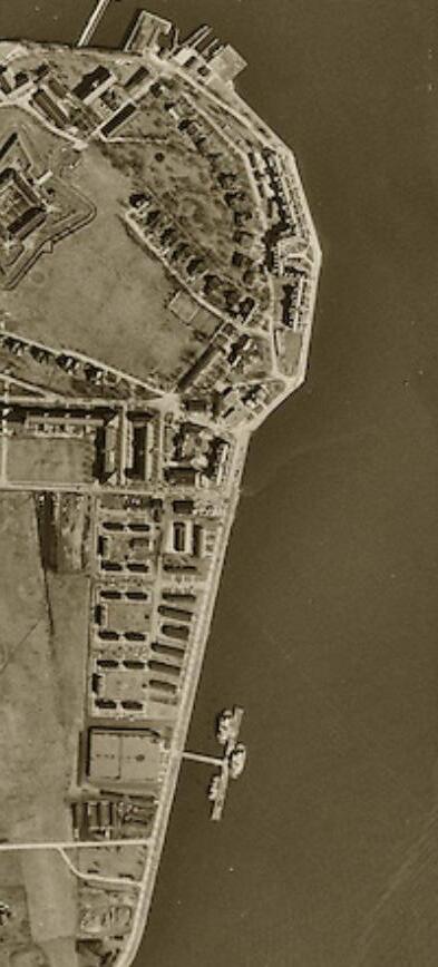
 Figure 3.1- Google earth Image highlighting the edge and the Governor’s Island
 Figure 3.2- Evolution of Governor’s Island from 1624 to Present
As in the previous chapter, people are living on the water, humans are moving towards floating houses more than on the land. The lateral forces are just commuting from the city to the houses. The houses mentioned in the previous chapter are mostly off-grid producing their own energy with solar panels etc. The lateral forces on the island in terms of commute is huge.
Governor’s Island is viewed as an object of revenue generation and has been developed in a certain way. Governor’s Island did not have free drinking water until now but if Governor’s Island is thought to be fully functional it has provision for free drinking water.53 In that case, the governor’s island becomes an industry or a plant to produce purified drinking water or filtered nondrinking water which will be collected from the sea. However, reusing the space would certainly not address the housing crisis but it is used as a leisure space and not a land for adaptive reuse. If the Governor’s Island becomes an industrial plant for water treatment, it definitely becomes a part of the grid of distributing water rather than being a
landmark.54
One of the aspects of the “Good city form” by Kevin Lynch is that it talks about Manipulability and reversibility. Manipulability means a point where changes can be made in the form or the usage of the space. 55
If we observe closely and understand the definition of Urban Artifacts, they become an architectural language or symbol for that particular space. Here, Governor’s Island is an artifact surrounded by public space that is water. This water is a built space. It has tunnels going underneath connecting one edge to another.
Governor’s Island is visualized to be a leisure spot and is often visualized as a promoting center for Green Landscape. It is to attract tourism and generate revenue. What if the island is used to generate something that is a basic necessity of human beings? Water!
As of 2015, according to the statistics, 29% of the total population does not have easy access to drinking water.56 In New York, easy
54 “Good City Form by Kevin Lynch,” accessed April 6, 2023, https://contensis.uwaterloo.ca/sites/open/courses/SustainableCities/ toc/module-3/04-good-city-form-lynch.aspx.
55 Video“Good City Form by Kevin Lynch,” accessed April 6, 2023,
56 National Geographic Society. Water Inequality, National Geography, May 2022, https://education.nationalgeographic.org/ resource/water-inequality/.
water access has made our lives more comfortable, which in turn leads to water wastage. If Governor’s Island is to be seen as a plant that is converted into potable and non-potable water, many neighborhood spaces (land) can be benefitted. As a prototype, there is a proposal for House 14 which is a house built during military episodes on the island. The proposal includes collecting rainwater and converting it into drinking water. It is interesting to understand how architectural intervention in space can cause discomfort for us to use only the required amount of water. In a way, it actually helps save more water because the proposal only focuses on collecting so much rainwater that is required.
On a miniature scale, house 14 becomes an urban artifact. The house is creating a prototype, experiential and experimental living in order to design a system that provides comfort in accessing the required amount of water but generates spaces that are not labeled as easy in architecture in terms of accessibility. House 14 for the Island becomes an artifact. The house is used for adaptive reuse but is designed to question the consumption of potable and non-potable water, and how architectural discomfort can lead to self-awareness of the usage of resources.
The island as an urban artifact becomes a habitable, breathable
artifact where people can come and spend some time with their families. The island is also used as an exhibition space in order to have exhibitions on the island.
If the island becomes a space for the purification of water, then the question is who all will have the authority to access it? It will still be owned by the government and it will still be accessible but the by whom? If space is utilized for a cause that benefits the community to provide a basic human necessity, will it be viewed through the lens of Urban Void?
The island will still be a built space but it will be semi-public/semiprivate. The shape of water will evolve. It is speculated that due to climate change, the sea levels will rise and only a certain part of the south of Governor’s Island will be visually available. The water will again overpower the land.
The island is going to be submerged. What is more important? Saving the land on which many other possibilities can take place? Or generating revenue by making it a tourist place. All the proposals that try and fit architectural language into the landscape so that the island becomes a space of leisure, awareness, and revenue generation seem pleasant through the lens of a false happy ending. However, the question still remains the same, is it really worth it?


 Image 4.1-Section of Old Croton
Image 4.2-Emerging Manhattan Plan
Image 4.1-Section of Old Croton
Image 4.2-Emerging Manhattan Plan


 Image 4.4-An Early Image showing Croton Aquaduct
 the Old Croton Aqueduct, “The Old Croton Aqueduct: An Engineering Marvel,” Friends of the Old Croton Aqueduct, January
Image 4.5-Opening of the Duct
the Old Croton Aqueduct, “The Old Croton Aqueduct: An Engineering Marvel,” Friends of the Old Croton Aqueduct, January
Image 4.5-Opening of the Duct


 Image 5.2- Internal View of Houe

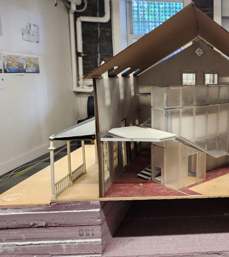 Image 5.3- Internal View of Houe


