
28 minute read
A GEODESIGN APPROACH TO SUSTAINABLE DEVELOPMENT ON JEKYLL ISLAND


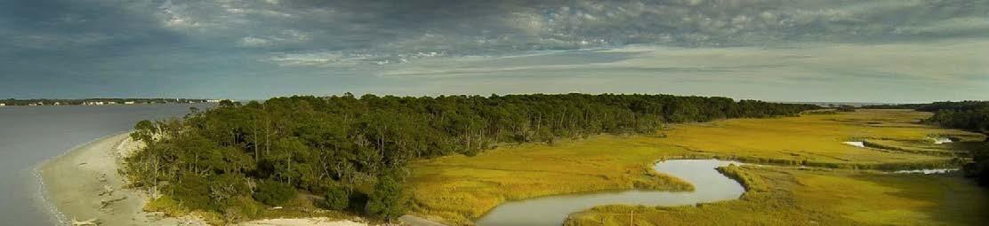
FIG 1:Panorama of Jekyll Island. Image Credit: www.jekyllisland.com
In his book, “A Framework for Geodesign,” Dr. Carl Steinitz states, ”The framework for a particular geodesign study will be shaped by its many participants, and especially by the issues and requirements posed by the people of the place.(1)” This is especially true of Jekyll Island, Georgia. Jekyll Island is a 5500-acre barrier island with unique history and characteristics. There is pristine natural beauty, affordable and diverse tourist, entertainment, and recreation opportunities, and easy access to plentiful amenities.
The people that live, work, and visit this area all claim that the island has a special qualities that cannot be found in many other places. They all feel connected to the land and the unofficial motto: “Island Life for the Average Georgian” is being resonated in many ways. This quote from the 2011 conservation study sums it up well: “Georgia law specifically designates Jekyll Island as a State Park, meaning that the land and its flora and fauna belong to all citizens of Georgia.”(2)
Jekyll Island faces many issues with the main one being that the is island being “loved to death.” Statistics and demographic studies show that population in Georgia is increasing (3), which will lead to an increase in visitors to the island. The threat of sea level rise, an increase of high-level flooding, and the potential for more frequent devastating hurricanes and storms all have the potential of causing significant pressure on the island. How can the Jekyll Island take steps ensure that the resilience of the island increases with these different pressures? Jekyll Island has a unique governing structure as the Island is overseen by the Jekyll Island Authority (JIA) which is a Georgia State Agency.
“Recognizing that Jekyll Island’s natural beauty and vibrant history set it apart from any other coastal retreat, the Governor and the Georgia State Legislature established the island as a state park and entrusted its care to the Jekyll Island Authority. The Jekyll Island Authority is a self-supporting state agency responsible for the overall management and stewardship of Jekyll Island.” (4)
As stewards of Jekyll Island’s past, present and future, we’re dedicated to maintaining the delicate balance between nature and humankind.(5)
- JIA Mission Statement
This report outlines how the geodesign framework could be used to help Jekyll Island plan for its longterm future.
Dan Meehan Capstone Project – Final Report Advisor: James Sipes Penn State University MPS in Geodesign – AUGUST 2019
Discovered by General James Oglethorpe and named In honor of Sir Joseph Jekyll
Senator Nelson Aldrich led a party of financial leaders to Jekyll Island to create the forerunner of the Federal Reserve.
GA Law Established: Only 35% of land may be developed

French Discovery
1562 1733
Sea cotton plantation
1792
Hunting Club: Rockefeller, Morgan, Vanderbilt, Pulitzer, Baker.
1886 1910
Sold back to state. Established as State Park.
1947 1971
Max of 1675 Acres can be developed
2014
FIG 4: Jekyll Island timeline. Image Credit: www.jekyllisland.com
PROJECT SCOPING The First Iteration
1.1 REPRESENTATION
Jekyll Island has unique history since the French landed there in 1562. It has been a plantation, hunting getaway, closed for war and reopened as a state park.
The 2014 master plan outlines that only 1675 acres can be developed (8). Currently there are 1609 acres of developed land leaving only 64 acres which have been designated or designed as either developed or undeveloped. According to JIA: “All of the acreage not currently classified as developed is in fact undeveloped. The 64 acres is the hypothetical amount that developed land could potentially be expanded. Only 20 acres of this could be utilized for commercial or residential purposes. The other 44 acres is hypothetically available for development with an explicit public purpose and use e.g. infrastructure, access, safety, etc.”(9) This does not leave much wiggle room.
More recently the JIA has placed an emphasis on a variety of issues that are getting increasingly important. Important Issues:
Controlling Number of Visitors Development of Vacant Lands Housing for Residents, Workforce, & Visitors Infrastructure Improvements & Enhancements Impact on Natural Areas & Systems Long Term Carrying Capacity Climate Change & Sea Level Rise Natural Disaster & Flooding
1.2 PROCESS
In a geodesign study a process can be thought of as something that happens with a site that can be related to physical, ecological, human, or geographic characteristics. On Jekyll Island, the most critical of systems are natural or related to preserving or protecting natural systems. Also of importance is how humans interact with those systems in a way that can be sustained for many years into the future. Without long term economic viability, nothing that happens on this island would be possible. This report outlines how geodesign can take on all of these issues in a symbiotic manner.


FIG 5: There are 3.5 golf courses on Jekyll Island and over 20 miles of safe bike trails.
1.3 EVALUATION
Jim Remlin
“It is the people of the place who most directly know and perceive the conditions of the study area, and which aspects are working well or not.” (10) Jekyll Island benefits from having multiple studies at its disposal, all of which were used in this project. Some of these studies included numerous interviews with various stakeholder groups that represent different interests on the island.
1.4 CHANGE
Regardless of what actions the JIA undertakes, the island will need to adapt. Change from within JI might not happen too rapidly, but processes and systems outside of the island will change rapidly. This will apply more pressure on the island to change. And pressure from the residents and homeowners will only get louder. This will be taken into consideration. In many ways and both offensive and defensive strategies need to be implemented to handle this change. 1.5 IMPACT The beauty of Jekyll Island is also it’s largest weakness. The pristine natural beauty is also extremely fragile. If the land is not protected and managed properly, this unique resource could be lost for good. Sea level rise and frequency of intense storms are increasing and could cause harmful change, the island needs to be prepared properly. If no action is taken, the impacts could be serious or irreversible.
1.6 DECISION
The geodesign team will need to sort through the ample amount of information that is available to them in order to determine the proper sequence of events that need to occur on the island. Ultimate decision making will come from the JIA, but they need to be sure that the decisions they make align with the values of the people of the place and backed up by the scientific data to support the decisions.
FIG 6: Beautiful beaches and dunes (left). The Horton House was constructed in 1743 (right).


There are numerous stakeholder groups that have provided input to this study.
STAKEHOLDERS:
Jekyll Island Authority • Executive Committee • Conservation • Historical • Facilities, Operations, & Infrastructure • Recreation State of Georgia Business Owners Residents & Homeowners Tourists Beach Goers Bicyclists Camping and RV Wildlife Observation Sea Turtle Center and Hospital Conservation and Protection Groups Flora & Fauna
There is both agreement and contention between these groups that will need to be managed and negotiated. In addition to physical boundaries such as the shoreline and rising ocean levels this study includes detailed information about the values of the people of the place. There are cultural, authoritative, logical, rational, and emotional values that will all need to be considered. While the island has many physical limitations, the largest bounding factor is the law that says only 64 additional acres can be developed.
This completes the first iteration of the study which focuses on the scoping aspect of this Geodesign problem. This phase was intended to be a quick look at the study area and to provide some initial information in order to develop the next step, outlining the methods of this process. We can now begin to outline the purpose of this study:
PURPOSES:
Provide guidance to the decision makers of this island. Utilize a transparent process for allowing all voices to be heard. Protect the island and ensure that it can be enjoyed by future generations. Identify actions that need to be undertaken by both the public and the government. Determine the best path for being responsible stewards of the land. Devise plan to conserve environment and encourage sustainability. Accurately measure existing conditions by understanding systems. Identify redevelopment opportunities Determine Suitability of proposed changes.. Generate scenarios for long term planning purposes.
FIG 7: Contention is a constant in a geodesign study. This political cartoon is an example of some stakeholder’s current opinions of the JIA. (Sam C. Rawls. www.savejekyllisland.org)

CAMP JEKYLL AIRPORT
HISTORICAL AREA
SUMMER WAVES
VILLAGE FISHING PIER
RV LOT
GOLF COURSES (3.5)
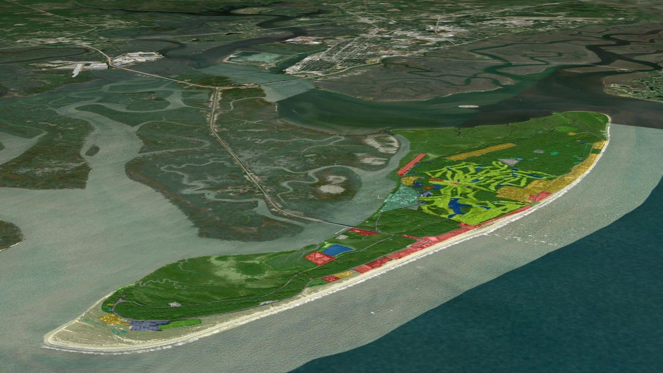
FIG 8: Oblique view of Jekyll Island with major attractions labeled.
PROJECT METHODS
The Second Iteration
2.1 DECISION
We now start to ask the questions about how this study will take place. How will the decisions about what change happens on JI be made, and by whom? In this case, the Jekyll Island Authority Executive Board has full control over any design or change decisions that happen on this island. Similar toany municipal governing body, project proposals need to get approvals and go through a formal planning and review process for any new construction or modifications on the island.
In order to make decisions, JIA will need clear and concise information upon which to draw. This will require synthesis of existing studies that can be easily accessed. We used a variety of spatial tools and mapping data to assess this information includingan online collaboration tool called Geodesign Hub (GDH).
GDH provides a transparent system of record for solving complex land use issues that have many stakeholders and systems operating in the same spaces.
Data: Esri, Jekyll Island
GDH allows for anyone who wants to have a say on what should happen in a project to have their say. As Dr. Steinitz says: “Understanding how public and private decisions to alter or conserve the landscape are made within that geodesign context is a basic element of a geodesign methodology.” (11)
Throughout this process, we encouraged JIA to utilize the existing scientific evaluations that are available to them. In the case of JI, we are fortunate to have multiple existing studies that have been done on JI. Each study was analyzed in detail to summarize the findings and conclusions.
EXISTING STUDIES:
2008 – Coastal Hazards Assessment
2011 – Conservation Study 2014 –Master Plan Study 2016 – Transportation Study 2017 – National Golf Foundation, Golf Study 2018 – Infrastructure & Carrying Capacity Assessment


Jim Remlin
FIG 9: The Village is a popular place with shops and restaurants (left). The JI Campground has over 20 acres for all sizes of RV.
In addition to the studies listed above, JIA personnel have integral, institutional, and historical knowledge of the island process and operations. Some have been coming to this island since they were children. Their inherent knowledge of the place was heavily relied on for this study. JIA staff resources were also utilized to help determine which additional stakeholder input needed to be included. Regular JIA board meetings were used as sounding board throughout the process.
2.2 IMPACT
A goal of this project is to help the JIA outline both vulnerabilities and opportunities within the island. The existing studies will be broken down and itemized to find where there is agreement and where there is contention. This process will help them determine which values are important to each of the stakeholder groups.
The saying “Island life for the average Georgian” has been a recurring theme in this process. This means that there is consensus on this island remaining an affordable location for all Georgians to visit. No matter how the island changes in the future, it should still be accessible to those who want to get here. This can be accomplished by continuing to offer low-cost recreation opportunities, free beach access, and by keeping lodging costs low. Once the information from interviews and existing studies is synthesized, it will be organized in rank order so that priorities may be determined. The metrics to measure suitability and vulnerability for each system will be discussed and agreed upon so that the project team is all on the same page.
2.3 CHANGE
Change is a constant on Jekyll Island on numerous scales. The State of GA requires that all plans address a 2’ Sea Level Rise. No matter when it happens, this would be a direct impact to JI. And with storms and flooding increasing in magnitude, the vulnerability of the island is ever increasing.
General population increases in the state of Georgia will likely mean an increase in visitors. Jekyll Island needs to be prepared to handle that without the ability to use more than 20-acres for development. Existing pressures from both the inside and outside of the island were addressed in this study.
Change will be proposed in the form of diagrams in GDH. A diagram can be thought of as a project, or some change that will take place on the land. A series of diagrams will then be selected to make a design.
FIG 10: The Georgia Sea Turtle Center releasing a rehabilitated turtle back into the wild. (left). Summer Waves Water Park (right).


Jekyll Island’s natural beauty makes it a very attractive place. There are some areas of the island that are functioning well and others that are operating at a financial loss. The island gets about 40K visitors a year and that’s expected to increase as the state population increases (12). As indicated earlier, the island’s land development capacity has nearly been met. One question to consider in the evaluation process is how can JIA increase economic viability within existing developed land.
The locals take pride in the lack of development and often reference their noisy neighbors to the north, St Simons Island (SSI), as a place they do not want to become. SSI is overcrowded and largely developed. At the opposite end of the spectrum, Cumberland Island, located just south of JI, is a National Seashore and is largely undeveloped. Each of these areas will be compared in the evaluation process.
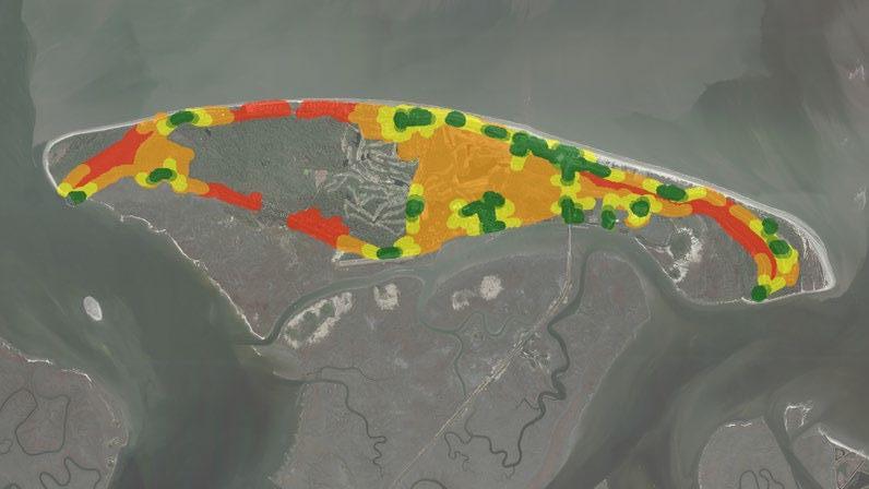
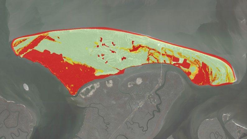
Geospatial tools and technologies were used to evaluate existing conditions on the island. The team used the existing studies and information collected to determine the most important systems that operate on the island. Once systems are determined they were evaluated for suitability for change. The scale used to make the measurements is red, yellow green.


FIG 11: GDH scale for suitability for change.


For this study we used the following suitability criteria:
RED = Existing – This land is operating well in this system context. It does not need to change. YELLOW = NOT APPROPRIATE – This land is not appropriate for this system. It does not need to be considered for change. GREEN = SUITABLE – This land is not functioning well in its current context. It is suitable for change.
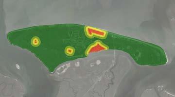
FIG 12: The map showing the evaluation layer for the Recreation, Entertainment and Tourism (RET) system.

As an example, we have provided a map (FIG12) showing the evaluation GIS layer for the recreation, entertainment, and tourism (RET) system. The areas in red are existing RET functions or activities that are operating well, these areas should not change. The areas in yellow are not appropriate for change to RET function. For example, the northwest part of the island is largely tidal flood basin, this area will never be a suitable place for any type of RET function. The areas in green are suitable for change to a RET activity. These areas are not operating well and would be suitable for change to RET functions.
2.5 PROCESS
We again rely on the past studies conducted by the JIA to help determine which processes are the most important on JI.
Approximately 70% of Jekyll Island exists in its natural state. There are numerous species of flora and fauna that are present on this island and they need to be protected as coastal barrier islands are under constant change and pressure.
Once again, all the previous steps in this geodesign framework have helped to drive this part of the study. We can begin to outline the processes or systems that will need to be evaluated for this project and break them into relevant categories.
Current Developed Land
64 Acres to be Developed
Developed
1,609 –30%

N Undeveloped
FIG 13: Current breakdown of developed land as determined by the 2014 Master Plan.
3,920 –70%
This is an initial list of systems that are operating on JI. Some of the initial systems include:
Physical: • Utility • Roads • Bike Paths • Beaches • Historical Area • Accessibility • Commercial Development • Hotels • Parking • Golf • Maintenance Ecological: • Natural Area • Tides • Sensitive Flora • Fauna Habitat • Wetlands • Conservation Areas • Coastal Ecosystems Human: • Recreation • Tourism and Eco-Tourism • Resident • Events • Housing Availability • Sustainability Social • Economic Sustainability • Environmental Education • Affordability
This initial list will be narrowed down based on the information gathered by the geodesign team. Issues such as model complexity and how they should be visualized will also need to be determined by the team.
2.6 REPRESENTATION
In a typical project involving the use of geospatial technologies, a common first step is to search for data that is available to the team. The geodesign framework differs in that the data collection effort truly happens at the end of the outline of methodologies.
Total Acres based on NOAA Mean High Water Estimate. According to 2014 Master Plan.
FIG 14: Current Land Use map as outlined by the 2014 Master Plan.

The geodesign framework dictates that the action of collecting geospatial information should not happen until the end of the scoping process. This allows the team to have a better understanding of what data is needed so they can focus on the important issues. The team will also have a solid grasp on how the information should be visualized and what tools and applications will be necessary. Fortunately, the scale of our project is not an issue as the island has a distinct boundary. That said, considerable pressure from forces outside of the island will be taken into account.
We now have a thorough understanding of the study area and what data is available to the team. We have also outlined methods for how this study will take place. We can now work to implement the plan to complete this project.
PROJECT ACTION
The Third Iteration
This aspect of the report will focus on how the project is implemented. The what, where and when questions will be addressed in this final iteration through the geodesign framework.
4.6%
70.9% 0.3% 0.…
12.8% 4.8%
4.1%
1.6%
3.1 REPRESENTATION
As indicated earlier, we will utilize GDH as a tool for negotiation. We will also use the ESRI platform and their suite of geospatial analysis tools to implement our project plans. These tools include ArcMap, ArcGIS Pro, ArcGIS Online (AGOL), and GeoPlanner, among others.
GIS DATA COLLECTED:
PHYSICAL
Parking Bike & Ped Trails Building Footprint Utility Facility Water Tower Water, Storm and Sanitary Lines Septic Tanks Hydrants Roads Tax Parcel
NATURAL
Vegetation Species Beaches Land Use Boundary Shoreline Soils Golf Course 1FT Contours Elevation Model
Most GIS data was provided by JIA and Glynn County and some was collected using outside sources. An initial data assessment was performed to figure out what information needed to be updated or added.
In addition to the data listed above, the team created their own GIS data to supplement what was provided. Cloud based data storage, including AGOL, was used to share data and information among the team.
3.2 PROCESS
The team identified all natural, physical, cultural, and social “systems” that are operating on the island. They narrowed down the relevant systems to use in this study to the following ten (in no specific order):
SYSTEMS
1. Residential
• Single family homes, apartments, longterm-lodging.
2. Transportation
• Public roads.
3. Parking
• Existing general parking areas.
4. Commercial / Hotel
• Existing businesses and hotels.
5. Eco Tourism
• Bike and pedestrian trails, environmental education, ecological friendly activity.
6. Recreation, Entertainment, Tourism
• General category for all recreational, entertainment and tourism activities.
7. Golf
• Existing golf courses.
8. Medium Density Development
• New development that is medium density.
Could include mixed-use, housing, institution, or commercial.
9. Coastal Ecosystem
• Environmental systems and green infrastructure.
10. Historical Area
• Areas that are of historical significance to the island.
A separate GIS layer was created for each system and the entire island was evaluated for its suitability for change. Each of the system GIS layers were created by evaluating the land for its suitability for change. These maps help guide the geodesign team in determining which areas will be suitable for different needs of JI. Each system is listed below and named along with their GDH abbreviation.
FIG. 15 RESIDENTIAL - RES

FIG. 16 TRANSPORTATION - TRANS

For this project, these are the change teams that were chosen. These teams represent the goals of multiple stakeholders who share common interests:
CHANGE TEAMS AND GOALS:
HISTORICAL: Protect and enhance existing historical areas
• Education: Continue to educate the public on environmental stewardship • History: Ensure future generations can continue to learn about the past. The JIA must act quickly in order to protect the island’s unique natural resources while allowing for sustainable FIG. 23 COASTAL ECOSYSTEMS - ENV FIG. 24 HISTORICAL AREAS - HIST There are proposed changes and potential projects that are already being planned for JI. Each of these projects, as well as other ideas proposed by people of the place and stakeholders, were added to GDH in the form of a diagram. The diagrams are organized in categories that align with the systems. 3.4 CHANGE • Attitude: Relax, disconnect, unwind • Accessibility: Easy and affordable recreating opportunities • Conservation: Protect natural beauty and vibrant ecology • Protection: Maintain “Island life for the average Georgian.” In addition to evaluating the systems the team is also able to succinctly outline the values of the people of the place. As indicated earlier, these values should be the driving force behind the decisions that are made by the JIA. development or change within a limited capacity. In order to have a full understanding of the path forward, they also need to recognize the risks that they are facing: • Overuse of the island • Demands on infrastructure and services • Pressure to increase tourism and revenue • Development threatens fragile ecosystems • Climate Change & Sea Level Rise FIG 25: Diagrams from Geodesign Hub. NATURAL: Ensure natural areas will not be
impacted TRANSPORTATION: Safe, easy, and dependable transportation systems. RECREATION: Affordable and diverse recreation activities. ECONOMY: Financial viability for the future.
Change teams then chose the diagrams that they thought were the most important. These diagrams make up a design in GDH.
3.5 IMPACT
In order to better understand the various impacts that might happen on the island from outside forces, spatial analysis was utilized. Impacts were assessed using ArcMap and ArcGIS Pro. Sea Level Rise will have impacts on JI but the JIA has already done a good job in planning the development on the island. Even a 5FT. SLR has minimal direct impact on existing structures and infrastructure. This can be seen by the maps depicted in this section.
RISE
Current
1 FT.
ACRES
5530
4270
DECLINE
-23%
3 FT. 3780 -11%
5 FT. 2745 -27%
FIG 26: Potential land loss due to Sea Level Rise. Data source: NOAA.
1 FT Sea Level Rise

3 FT Sea Level Rise
5 FT Sea Level Rise

FIG 27: Maps showing Sea Level Rise data from NOAA. Buildings are represented in green and extruded at equal heights. Red buildings are going to be impacted by SLR.
FIG 28. Driftwood Beach on the northeast side of Jekyll Island.

The decision phase is never simple. There is a lot of information to keep track of and sort through in a meaningful manner. The decisions that are made by the JIA are important and will impact the island for many years in the future. They must not rush into decisions without having been completely informed of all factors and potential outcomes.
FIG 33. Each hexbin in every layer in the model was rated from 1-5. 1 being the most vulnerable and 5 being the most suitable.

FIG 35. Individual suitability maps that went into the model.
INITIAL ANALYSIS
FIG 34. Part of a hexbin map that was used for the suitability modelling. Each hexagon is about 40x40ft and represents about 1/16th of an acre. In addition to the process described thus far, the geodesign team also assembled a suitability model, which is also known as a multi-criteria analysis. This task came about after JIA members expressed interest after seeing a demo from another project. The team had to work within limited technical scope as some of the latest tools to be able to produce this type of analysis were not available to them. The team used ArcMap and ArcGIS Pro to create a hexbin coverage of the area.

The JIA provided input on what layers they would like to see in the analysis. After the first demonstration of the tool, they decided to include additional layers, as depicted below.
SECONDARY ANALYSIS
ENVIRONMENTAL RISK PROXIMITY TO SANITARY ENVIRONMENTAL RISK v2


PROXIMITY TO PARKING PROXIMITY TO WATER PROXIMITY TO HISTORY

SEA LEVEL RISE FLOOD RISK


EVENLY WEIGHTED
LOW CLIMATE CHANGE


FIG 36. The maps that were provided to JIA as a result of the suitability modelling.
HIGH CLIMATE CHANGE

The team created maps from resultant suitability models which are shown in FIG. 35 above. For each model, the different layers were given a weight based on their importance to that stakeholder. They weights allow the user to see the most suitable or vulnerable locations based on their own values and priorities.
Additional layers were overlain on the suitability model to show areas that are considered constraints (FIG.36.). The environmental constraint showed vegetative species that are the most vulnerable and the developed land shows only the land that is currently classified as developed.
Another tool that that team created to assist them in the decision-making process is an agreement and importance table. This table takes the projects that were identified and ranks them in order of importance. The table also adds in where there is disagreement and agreement. This helps the team and the client determine which projects will be easy to implement and which will require more effort.
ENVIR CONST DEVELOPED LAND
FIG 37. The maps that were provided to JIA as a result of the suitability modelling.
FIG 38. Determining where there is the most agreement among important projects on Jekyll Island. Ranking of 5 is highest priority.

The table in FIG. 37 is a rank order of projects that are most important to stakeholders. Agreement is then measured by prioritizing the projects where stakeholders agree. Each stakeholder group ranks each project based on their own priority, giving it a value of 1 – 5 with 5 being the highest priority. We total the priority rankings to determine which projects are the most important to all stakeholders.
An agreement ranking is then calculated by giving a point to the projects that have the highest rankings. The projects that have high agreement and a high importance ranking should be the projects that are given the most priority. Building a new beach wall, connecting existing bike paths, enhancing the water park, and changing a golf course to a natural area.
Economic Sustainability Historic & Cultural
Design Timeline
Natural Resources Transport & Infra
The geodesign team has provided data and information that can be used by JIA to make final decisions about how Jekyll Island plans for future development. It will be important to include feedback throughout the process. If there are new ideas or issues that come to light as a result of the study, the information can be incorporated back into the models and re-analyzed.
The geodesign team would recommend that the JIA continue this process and utilize GDH to help them with determining the best plan for the future of Jekyll Island. The software will provide a transparent system of record that allows all voice to be heard and accounted for.
Budget & Cost Recreation
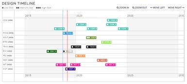

FIG 39. Some potential design ideas that were simulated based on feedback from stakeholders and public opinion. Designs can be compared against each other and budget info can be added.
CONCLUSION
The geodesign framework is best suited to solve complex issues that involve diverse groups with multiple stakeholders. The long-term planning for Jekyll Island was an ideal issue to utilize this framework.
This report outlines the process that was undertaken in an educational setting. In an ideal world, the JIA would take the information from this report and continue the effort in a more detailed manner. They could host a geodesign workshop using GDH, invite stakeholders and key personal to participate, and get a complete and holistic understanding of the issues that face their island. Most importantly, they would be able to produce a plan that would allow the island they love to continue to be enjoyed by their fellow Georgians and anyone who would like to visit this beautiful island.
FIG 2: Looking northeast at the Sydney Lanier bridge from the Jekyll Island Club Resort at low tide.

Dan Meehan Advisor: Jim Sipes Penn State University Capstone Project – Final Report MPS in Geodesign – AUGUST 2019

SOURCES AND CITATIONS
(1) Page 1 – “Chapter 3.” A Framework for Geodesign: Changing Geography by Design, by Carl Steinitz, ESRI, 2012, pp. 25–25.
(2) Page 1 – Jekyll Island Authority. (2014). Master Plan & Annual Report. Retrieved from: https://www.jekyllisland.com/jekyll-island-authority/master-plan- annual-report/
(3) Page 1 – Jekyll Island Authority. (2018). Carrying Capacity and Infrastructure Assessment. PG25. Retrieved from: https://www.jekyllisland.com/jekyll-island-authority/jekyll-island-carrying-capacityinfrastructure-assessment/
(4) Page 1 – “Jekyll Island Authority.” Jekyll Island - Georgia's Vacation, Conservation and Educational Location, http://www.jekyllisland.com/jekyll-island-authority/
(5) Page 1 – “Jekyll Island Authority.” Jekyll Island - Georgia's Vacation, Conservation and Educational Location, http://www.jekyllisland.com/jekyll-island-authority/
(6) Page 2 – Steinitz models adapted by D. Goldberg from A Framework for Geodesign: Changing Geography by Design, by Carl Steinitz, ESRI, 2012.
(7) Page 2 – AECOM. (2011). Jekyll Island Conservation Plan. PG6. Retrieved from: https://www.jekyllisland.com/jekyllislandwp/wp-content/themes/jekyllisland2016/files/conservationplan-2011-09.pdf
(8) Page 3 – Carl Vinson Institute of Government, University of Georgia. (2014) The Jekyll Island Master Plan, PG 24. Retrieved from: https://www.jekyllisland.com/jekyll-island-authority/masterplan-annual-report/
(9) Page 3 – Jekyll Island Authority. (2018). Carrying Capacity and Infrastructure Assessment. JIA Comments. Retrieved from: https://www.jekyllisland.com/jekyll-island-authority/jekyll-islandcarrying-capacity-infrastructure-assessment/
(10) Page 4 - A Framework for Geodesign: Changing Geography by Design, by Carl Steinitz, ESRI, 2012, pp. 38.
(11) Page 6 – “Chapter 3.” A Framework for Geodesign: Changing Geography by Design, by Carl Steinitz, ESRI, 2012, pp. 29.
(12) Page 8 – Island Authority. (2018). Carrying Capacity and Infrastructure Assessment. PG38. Retrieved from: https://www.jekyllisland.com/jekyll-island-authority/jekyll-island-carrying-capacityinfrastructure-assessment/


