

LANDSCAPE ARCHITECTURE PORTFOLIO

Hannah Jiaming Lin
Bachelor of Landscape Architecture (Hons)
University of New South Wales

PERSONAL STATEMENT
Hannah Jiaming Lin
Bachelor of Landscape Architecture (Hons)
The University of New South Wales, Australia
E-mail: jiaminglin7210@gmail.com
LinkedIn: linkedin.com/in/hannah-jiaming-lin
WORKING EXPERIENCE & ACTIVITIES
Design Office Experience:
Hannah has graduated from the University of New South Wales with a Bachelor's degree in Landscape Architecture (Honours) and has about one year of internship experience in design office and landscape industry work. Hannah's passion is creating an inspiring, functional, sustainable landscape design for communities. Throughout her academic career, Hannah has been researching the concepts of community-led design, mixed-use communities, Urban Farms, and dealing with the challenge of population growth, Urban Heat Islands and river floods. As a landscape architect, Hannah cares about human benefits as well as animal and ecological benefits.
EDUCATION
2015-2018
2019-2023
(QCE International Education program)
The University of New South Wales, NSW, Australia
Bachelor of Landscape Architecture (Hons) Dongfang High School, Hangzhou, Zhejiang, China
TECHNICAL SKILLS

Intern at landscape team of Huachengboyuan Construction Engineering Co., Ltd. as Student Landscape Architect 09/2022 - 12/2022 Hangzhou, China

• Participate in the design process of two projects.
• Project 1:
Landscape Improvement Scheme Design of Hebi City Rong Media Center in the City of Hebi. A commercial project. General project assistance, site visit and analysis, rendering, 3D modelling and report preparation by using Adobe photoshop, illustrator and indesign, AutoCAD and Sketchup software.
• Project 2:
A residential landscape design project in the City of Hangzhou. Bubble diagrams, sketch design, hand-drawing skills, concept designs, materials research
Landscape Industry Work Experience:
Intern at Randwick City's Bushcare and Parkcare as Bushcare & Parkcare Program Member 03/2023 - 12/2023 Sydney, Australia


• Randwick Council has 15 Bushcare sites and 2 Parkcare sites guided by the Council’s Bushcare Officer. We go to which site is based on the Bushcare Calendar and weekly emails, and Hannah has been to 9 sites already.
• Removing weeds and helping native plants grow
• Installing wooden sticks to stabilise slopes and prevent soil erosion.
• Planting native plants and revegetating bare patches to increase the aesthetics and provide habitat for local fauna.
• Mulch garden beds and prune vegetation to maintain the native garden
• Developed skills: hands-on experience, learning how to use Bushcare tools, connecting with the local community, increasing the knowledge of local flora and fauna, and gaining bushland and parkland management skills.
AWARDS
Shortlisted for The Tract Consultants Portfolio Prize, for an outstanding portfolio submission by a third year student in the Bachelor of Landscape Architecture program (2022)
ACKNOWLEDGEMENT OF COUNTRY
I acknowledge the Bidjigal People as the traditional custodians of the land where my campus is located. I pay my respect to the Elders of the past, present and future for they hold the values, culture, memories and hope of the Australian landscape.
I value their continuing connection to Country and profoundly appreciate their shared knowledge, allowing me to deepen my understanding of the land and become a better landscape architect.


01 A LANDSCAPE RECONCILED: GOORIWAL
[4-5]
02
CONTENTS 03
COCKATOO ISLAND JOURNEY
[6-7]
04 05 06 PEDAL
SPIRIT
[8-15]
IMMERSE IN NATURE
[16-23]
GRADUATION STUDIO (LIVERPOOL)
[24-27]
INTERDISCIPLINARY WORKS + INTERNSHIP
[28-30]
A LANDSCAPE
RECONCILED GOORIWAL (LA PEROUSE)
LAND2101
Landscape Studio 1: Design Fundamentals
Term 2, Year 1, 2020
Location
La Perouse, Sydney, Australia
Project Background
Aboriginal Australia’s connection to this land mass is some 60,000 years old and this continuous connection, past and present is one of the most endearing and authentic qualities of this great country.
However, this relationship is fraught as there are large disparities between the broader communities understanding and recognition of Aboriginal People within Australia. Reconciliation in this context is about the wider Australian community building relationships of respect and trust with Aboriginal and Torres Strait Islander Peoples. (LAND2101 Lecture 2020)
The site for this Assessment is Gorriwal, the headland, at La Perouse, 17.5km south of the Sydney CBD on the northern headland of Kamay Botany Bay. The site is a contested site, a palimpsest of past histories and future possibilities. The site is the location of early French and English colonial interactions with the Australian land mass and people.
As a landscape architect, we can reconcile these relationships through spatial justice. To strengthen relationships between Aboriginal and Torres Strait Islander peoples and non-Indigenous peoples. In 2020, we reflect on the 250 year anniversary of Cook’s arrival and subsequent impacts of this invasion.
Site Analysis | Broader landscape room of Kamay
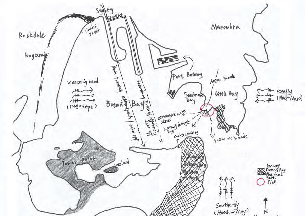

For a broader analysis diagram of the Kamay Botany Bay, La Perouse headland is located on the southeast of Botany Bay. National Park is to the south of the headland, Sydney Airport is to the northwest of headland, and Pacific Ocean is to its east.
General Statement About Reconcilation
For an analysis diagram of the headland. Looking out from La Perouse headland, expansive view across Kamay Botany Bay, view Kamay headland, Kamay National Park and expansive view to threshold space of headland.
Site Analysis | site selection

The site is located in the southeast of headland, facing Congwong Bay. Chosen site with one side near the water and the other side closest to the entrance intersection to the headland. The height difference between the two ends of the site is about 12m. The upper part is bush, and the lower part is reef, which is challenging for design. This site is relatively hidden and quiet, suitable for people to ponder and imagine. The site has a wide view, overlooking the Bare Island and Henry Headland. People can enter the site from Anzac Parada and then follow the reef beach to Bare Island bridge. Add a different route for people to visit Island.
In 1770, Captain Cook came to Botany Bay. The collision between western culture and local culture resulted in conflict, which affected the environment and damaged the indigenous culture and ecology. We should respect and trust with Aboriginal and Torres Strait Islander Peoples. Reconciliation action enables western culture and indigenous culture to live together better, and heal the wound caused by the conflict. As a landscape architect, I reconcile these relationships through the design of the site, an ecological landscape integrated with the environment is created.
Sketch Iterations


The first drawing showing the original site. The elevation difference from northwest to southeast is 12m. The upper part of the site is shrubs, lawn and grass, the middle part is the reef rock and the bottom is the coast. For sketch iteration 1, what I want to do is to design a path going down along the contour lines in the shape of “s” letter, with stairs for steep places and ramps for gentle places. Two platforms are also designed, which are rest platform and viewing platform. Then developed it, sketch iteration 2. The upper part of the site is composed of vegetation, shrubs and stone path, while the lower part is composed of rock and steel structure stairs. In order to make the ramp gentler and more comfortable for people to walk, I developed it to three bends along the contour line. The route became longer, and the space experience is more varied.
Concept Plan 1:100 at A3

SIMPLY EXPLAIN CONCEPT
Illustrative Section 1:100 @ A3
LEGEND
1.ENTREANCE TO SITE
2.STONE
3.PLATFORM I
4. SMOOTH-BARKED APPLE
5.ACID SULFATE SOIL
6.A GATHERING SPACE WITH SANDSTONE SEATING
7.OCEAN
8.PLATFORM II
9.STEEL STAIR
10.CAST IRON BENCH SEAT
11.LAWN/GRASS
12. EXISTING LOW GRASS AND NATIVE VEGETATION (Blueberry ash, Flannel flower, Old man banksia, Warrigal Greens)1

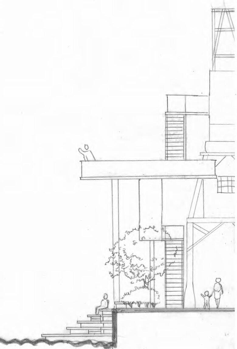
Then this is a longitudinal section, the upper part is stone path, existing shrubs, smooth-barked apple and cast-iron bench seating. The bottom part is steel structure stairs and floor.
The upper part of the site is composed of vegetation, shrubs and stone path, and the lower part is built with steel structure path on the rock, which does not damage the environment. The vegetation on both sides forms the edge. A platform is designed at the junction of the ramp and the steel stairs to see the bare island. There will be two different experiences of space. Put a cast iron bench seating through the site, so that people can sit down to see the sea, rest and think. It encapsulates qualities with diversity, mystery, prospect and refuge. And using paths, edges, foci and thresholds to enhance design.
This is Cross Section Elevation BB at 1 to 100. we can see it’s walk through from high to low.

6 Illustrative Perspectives


The first drawing shows the entrance to the site with smooth-barked apple and stone path in. The second drawing shows path and castiron bench seating. In third perspective, it shows platform 1, people in it can view bay and Bare Island.


COCKATOO ISLAND JOURNEY
LAND2102
Landscape Design Studio 2: Design Process
Term 3, Year 2, 2021
Project Location:
Cockatoo Island, Sydney, AU
Through design intervention, creating a new space and give people a more interesting and exciting experience to explore the island, to visit meaningful historical heritages and different point to view the beautiful scenery.
Design Statement
I take “view” as the theme throughout the whole design. Along the path journey, there are two historical heritages and a beautiful waterscape to be viewed. Around the site have many meaningful historical heritages and waterscapes. Such as the crane, the powerhouse chimney left over from the industrial era, an old boat and the convict settlement on the top of the cliff left over from the convict era.
The water rises and falls along the slipway, which is a good place for people to get in touch with the water. These heritages and waterscapes are in different directions and at different heights. In order to let people have a more interesting experience to view those heritages, and point the viewing of these three directions, I designed crane lookout platforms, a group of mounds and a sunken waterfront platform. These three parts enclosed a holistic space, providing different viewing points for people and a good place to rest and think.
Relevant analysis, concept and process drawings


Inspired by the design of silos steel bridge, I have a idea to design a steel stair around the crane from the ground to the top. I think climbing up and along the crane, this experience is interesting and excited, we can touch the crane in different height, feel it at a close range gives people a different experience. Inspired by the design of the Platform on the cliff, I design two platforms in different height level as well to view historical heritages (e.g.convict settlement) and the distant scenery (e.g.Woolwich Headland). And I made a model for testing my design idea as well.


Cockatoo Island Map:


There is a old crane in the site and other meaningful historical heritages near the crane. The crane and the powerhouse chimney are left over from industrial era. the convict settlement on the top of the cliff are left over from the convict era.


Broder Context Map:
Design Vision
Design Process:
A Landing Point Of Cockatoo Island And A Path To The Site Place:


Model Making
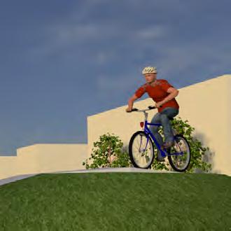
PEDAL SPIRIT
Courage-Exploreration-Innovation
LAND2202
Studio 4: Design Detail: Resolution + Representation Term 2, Year 2, 2021
Location:
Copenhagen, Denmark
Project Background
Copehagen has always been known for cycling, Cycling has always been a sport also a culture that Copehagen people like very much. The bridge will be designed for pedestrians and cyclists to strengthen the connection between the two sides of the river and become a city link and a landmark that inspires the world to choose cycling.
Project Vision
Interact with the space and facilities of the site through riding behavior, enrich people’s riding experience and cultivate people’s spirit of exploration and innovation.
Project Principles
· creating diverse communication spaces for cyclists and pedestrians
· Riding accessibility - bicycles can reach every conrner
· Touch the water
· Embody the spirit of exploration, innovation and adventure

Skills Developed:


SITE SURVEY & ANALYSIS
EXISTING CONDITIONS AND CONTEXT OF THE SITE

Site Broader Context
The design site is located in Copenhagen. The capital and most populous city of Denmark where populations moved to the urban areas in hopes of finding better options of job opportunities, education, shopping and entertainment (Everyculture.com, 2009)
- ISSUES
Issues
Bicycles are a symbol of moving towards a sustainable city. Learning from cities with prevailing bike cultures creates a unique opportunity to promotes cycling worldwide. To instil the culture of cycling around the world, more than just urban infrastructure is needed. A facility that enhances the experience of people, tourists, residents, visitors and students, one that intrigues them and excites them is needed.
Cycling in Copenhagen
C ycling has been officially recognized by The European Union as a practical mode of urban transport that generates environmental, economic, and health benefits. The Netherlands and Denmark have been especially successful in promoting safe and convenient cycling. Almost 41% of the commutes to work and study in Copenhagen is done by bike, and 62% of the city’s population are either working or studying (World Economic Forum, n.d.).

Copenhagen City Plan
- Consideration of connection points on both sides
- With the majority of visitors, commuters and citizens that live in the residential area would also travel past the inner harbour to explore the historical and cultural aspects of the city. Therefore, the bridge for our site would consider connecting these places.


Bridge Zone
The shape of the site boundary is trapezoid. It’s next to Knippels Bridge and Inderhavnsbroen Bridge. And besides the rejuvenation area: A proposed active community hub. With rich public spaces and community centres on both sides of the site, it is an ideal the location for a new public space.
ANALYSIS - SWOT ANALYSIS
STRENGTHS
WEAKNESSES
●
the shore There is not enough contact, and there is a lack of public communication space
● Lack of characteristics, Lack of green spaces Characteristics is limited surrounding the site. and the viewer scope is strait because the environment has no contemporary exciting and attracting space which cannot engage adolescent and the youth.
● Constraint: the bridge must be able to allow boats through, so ensure enough spaces for transportation under the bridge.
OPPORTUNITIES
● orient the bike lane along scenic routes to encouage commuters by car change in to by bike.
● A bridge that spans the river from shore to shore. Make full use of the waterscape. The bridge can involce exciting water activities or many competitions which can stimulate munipalities to the site.
● A bridge as a focus a landmark, a destination. Make the area look more attractive.
● An ideal location for a public space. Providing a public celebration space to
THREATS
●
●
●
●
Gammelholm
Christianshavn
KnipplesBridge
MASTERPLAN
Pedestrian bridge can be a place to meet, to socialize, to watch, and to gather.

The design required that having a 3.25m clearance to water, 15m width sea route for boats to pass through. So my bridge gradually rises with a slope of less than 1 to 20. However, the three spaces I designed are all flat. This naturally forms some sinking space. These spaces are backed by the main path of the bridge, which making some refuges.
SWIMMING AREA
-180cm deep adult area
-90cm deep junior area -250cm deep jumping area
-Changing room with a rooftop jumping platform
GREEN CORRIDOR, LAWN SITTING AREA
SPORT AREA
-Bike ramp
-Universal design, Wheelchair accessibility, 1in14 ramp
-Curved Wallride with mound, standing place -Benches
-Seating stair space, 1in14 ramp, stair
3.25m CLEARANCE TO WATER,15m WIDTH FOR BOATS TO PASS UNDER
BICYCLE RACKS AND RUBBISH BINS
CAFE, ROOFTOP SEATING SPACE, HERITAGE LOOKOUT
MAIN PATH FOR HIKERS & BIKERS
WATERFRONT AMPHITHEATER


DETAILED DESIGN

Around the site, there are a lot of historical aspects such as the Amalienborg which is the classical palace of the Danish royal family.
WATERFRONT AMPHITHEATER


BY NIGHT: Waterfront amphitheater can be used as a performance platform at night. Provide performance space for Musicians, street performers.
BY DAY: Waterfront amphitheater can be used as a waterfront platform during the day time. Providing people a place to playwater.


GREY IRONBARK DECK BRICK FLOORING CONCRETE
MASS PLANTING, KIKUYU GRASS
HANDRAIL TYPE FOR SPORTING


The bridge provides a vibrant public space for commuters and visitors to meet, to socialise, to eat, to watch, to gather. And cycling as its heart as a catalyst social connection, for shared experiences.
LAWN SITTING SPACE

WATERFRONT AMPHITHEATER
The waterfront amphitheater is 300mm higher than the surface of the water, it’s a space very close to water. It’s 2.5m lower than the surface of the bridge. It’s a relatively quiet space.

SPORT AREA
Cycling can not only save energy, it is conducive to the sustainable development of society, and can promote people's communication. It can also increase people's courage and cultivate a spirit of exploration and adventure.

PAINTED STEEL HANDRAIL
TIMBER DANISH HIBISCUS FLOWER
NORDIC PINE TREE
DANISH CAMPANULA FLOWER
CONCRETE CIRCULAR SEATING
DESIGN DOCUMENTATION


IMMERSE IN NATURE
Location
Project Background
Studio 5 and 6 are combined into one big project, which first works on the analysis of the Commons, the critical landscape systems that form and inform Angus and the scenario planning (Studio 5) and then create a Landscape Masterplan for Angus (Studio 6).
The site is located in Angus in Western Sydney, where it will transform into a denser human settlement over the next 20-30 years, and with more frequent flood risks.
Project Vision
Angus is going to address the need for housing and flooding issue in western sydney by using flood resilient design, as well as establishing a sustainable angus community with a good ecosystem.
Project Principles
1.Mitigation and adaptation for probable flood in Angus ("Very large flood" condition as well as "Biggest flood possible" condition) by using flood resilient design
2.Reestablish a mixed-use community, medium and high density residential housing area with varied infrastructures and recreational spaces
3.Create a multi-functional transport infrastructure with a walkable neighborhood
4.Provide a range of different recreational spaces for active and passive recreation for a range of user groups and communities
5.Create a good ecosystem of Angus through interactions and exchanges across heterogeneous landscapes to increase high biodiversity value and provide habitat for animals.
Skills Developed:


Marsden Park North (Angus), NSW, Australia


SITE ANALYSIS (STUDIO 5)
VEGETATION ANALYSIS
COMMUNITIES

The eastern creek catchment is feeded by many sub-catchments.
(adapted from source: State of The Waterways Management Plan-Eastern Creek 2005)

FLOOD RISK ANALYSIS
The Shale Plains Woodland within the study area is part of the Endangered Ecological Community Cumberland Plain Woodland. Due to the varying levels of historical disturbance, the community is consists of a mixture of good and poor condition vegetation.
Cover: 132.3 ha
It is a critically endangered ecological community under the EPBC Act 1999. Shale Gravel Transition Forest grades into Shale Plains Woodland as alluvial and ironstone influences decline. Cover: 65.8 ha
River
It is an endangered ecological community listed under the BC Act 2016. It primarily occurs on clay soils derived from Tertiary Alluvium, or on shale soils adjacent to the boundary with Tertiary Alluvium.


ha
Cover: 24.5 ha An endangered ecological community under the BC Act 2016. It occurred on the higher
Source: Biodiversity and Riparian Corridors Assessment 2018

VEGETATION ANALYSIS


Alluvial Woodland (EEC): Tree stratum: Eucalyptus tereticornis (Forest Red Gum), Casuarina glauca (Swamp Oak)
Shrub stratum: Bursaria spinosa (Native Blackthorn), Lycium ferocissimum (African Boxthorn)
Ground stratum: a mixture of native and exotic grasses and herbs
SITE CONTEXT @1:10,000 (Teamwork with Eric Chen, this diagram was drawn by me) (Teamwork with Eric Chen, this
Bird Habitat/ Wetland: Meadow or reedland with dominant species such as Ludwigia peploides subsp. montevidensis, Triglochin procera and Philydrum lanuginosum

The Alluvial Woodland within the study area is part of the endangered ecological community River-Flat Eucalypt Forest. It was associated with the drainage lines within the study area.
Cover: 83.8
Castlereagh Swamp Woodland:
Cooks
Castlereagh Ironbark Forest:
Alluvial Woodland:
Castlereagh Scribbly Gum Woodland:
Freshwater wetland:
Shale Gravel Transition Forest:
Shale Plains Woodland:
EDGE ANALYSIS PROJECTIVE DESIGN IDEAS FUTURE SCENARIO PLANNING


Shale Gravel Transition Forest (EEC):
Tree stratum: Eucalyptus fibrosa, Melaleuca decora
Shrub stratum: Bursaria spinosa, Daviesia ulicifolia
Ground stratum: Themeda australis, Opercularia diphylla
Shale Plains Woodland (EEC): Dominant tree canopy: Eucalyptus moluccana (Grey Box), Eucalyptus tereticornis (Forest Red Gum)
Shrub stratum: Bursaria spinosa (Native Blackthorn), Grevillea juniperina (Juniper Grevillea)
Groundcover: a mixture of native and exotic grasses and herbs
Cooks River Castlereagh Ironbark Forest (EEC):
Dominant tree canopy: Eucalyptus fibrosa and Melaleuca
decora
Shrub stratum: Daviesia ulicifolia, Grevillea juniperina.
Groundcover: Themeda australis, Opercularia diphylla
Castlereagh Scribbly Gum
Woodland (EEC):
Dominant tree canopy: Eucalyptus parramattensis and Melaleuca decora
Shrub stratum: Banksia spinulosa, Melaleuca nodosa
Ground stratum: Entolasia stricta, Themeda australis


(Teamwork with Eric Chen, this diagram was drawn by me)
(Teamwork with Eric Chen, this diagram was drawn by me)
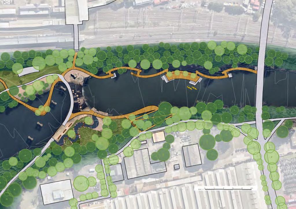
MASTERPLAN (STUDIO 6)

DETAILED DESIGN
PRINCIPLE 1
Mitigation and adaptation for probable flood in Angus ("Very large flood" condition as well as "Biggest flood possible" condition) by using flood resilient design
Seasonal Changes
I proposed some ephemeral wetland ponds near the existing watercourse, due to the retention capacity of the ponds, they can effectively mitigate flooding by temporarily holding water during the rain season and usual time.

Dry season

Rain season
The steeper the slope, the faster the stream flows, water flows slowly when it reaches a curve and this might cause a flooding, water flows quickly when it reaches a straight watercourse.
I proposed the high density residential area above the "Biggest flood possible" flood line and a bit modulatation of contour line.

Flood period
The blue area shows the flood prone in "Very large flood - medium chance" condition, In Marsden Park, a flood this size has a 55% chance of happening in an 80-year lifetime.
This is also referred to as a 1 in 100 chance per year flood.

The blue area shows the flood prone in " Biggest flood possible - extremely low chance" condition, in Marsden Park, a flood this size has less than a 0.1% chance of happening in an 80-year lifetime. This is the largest possible flood in the HawkesburyNepean Valley, also known as the probable maximum flood (PMF). Flood period
Reestablish a mixed-use community, medium and high density residential housing area with varied infrastructures


PRINCIPLE 3


PRINCIPLE 4
3.Good


Create a good ecosystem of Angus through interactions and exchanges across heterogeneous landscapes to increase high biodiversity value and provide habitat for animals.
BIRDS HABITAT

Catchment
Guide the rainwater from the nearby highland residential development through underground rainwater pipe system to fill the ponds during the dry season.


LEGEND
1.Wetland
Primary treatment zone
2.Large pond in the east
Secondary treatment zone, waterbody buffer (common waterbird foraging area)
3.Large pond in the west
Third treatment zone, waterbody buffer (common waterbird foraging area)
The two large ponds provide a wide expanse of approximately 7 ha of open water
4.The two smaller vegetated ponds in the north
The two vegetated ponds were dominated by bullrushes (Typha spp.).
The four ponds provides suitable breeding and foraging habitat for a number of migratory and local native bird species.
5.Mudflat
Migratory shorebird foraging area
6. Floating Wetland Island
7.Bird watching shelters access through small winding trails
8.Boardwalk (walking, runing, cycling)


Bird watching shelter
Floating Wetland Island
Design Inspiration: Diagram depicting shorebird disturbance buffer scenario
GRADUATION STUDIO (LIVERPOOL)
LAND2311
Term 1, Year 4, 2023
LAND2312
Term 2, Year 4, 2023
9:
LAND2312 Studio 10: Graduation
Term 3, Year 4, 2023
Project Background
Studio 8, 9 and 10 are combined into one big project - our graduation project. To accommodate population growth, as landscape architects on such projects we are primarily concerned with how to accommodate increased urban density while improving ecological and social conditions. We first work as a five-person group on analysing the existing site conditions of a given urban precinct, creating an Urban Landscape Structure Plan, and then work as an individual on developing more detailed plans, sections and visualisations at the neighbourhood scales.
Project Vision
Liverpool City will be imagined as a vibrant, sustainable and inclusive urban oasis that fosters a strong sense of community and connection with nature. Our approach centers on creating vibrant and compact street life that encourages walking and social interaction.
We aim to provide active modes of transportation and create an environmentally friendly transportation system like walking and cycling. It will links residents to neighborhood facilities and promotes active and healthy lifestyles. We propose to integrate green infrastructure such as green drainage and WSUD into the streets design to manage stormwater runoff while providing visual interest and ecological benefits.
And also by accessing to water and adding shade trees, community gardens, and green roofs, we aim to improve the neighborhood’s sustainability and livability. Nevertheless, it will also enhance air quality, reduce the negative impacts of urban heat islands, and foster the production of regional food system.
Existing Context And Conditions Of The Site


By 2050, Liverpool will develop into the Metropolitan Cluster, with a distinctive and welcoming character where people want to live, work, invest, study and play, and the premier edge city for Western Sydney Airport.
The population for the Liverpool City Council area is forecast to grow by 125,401 people by 2041, making the total population size 371,303. The suburb of Moorebank, which includes part of our study area, is forecast to grow by 13,710 people by 2041.
Main Characters And Issues Of The Site


• Liverpool Station has a direct interchange to the Bus Stands and plenty of bus service.
• Most bus routes are stopped at Liverpool Interchange and concentrated in CBD, while other parts (including Study Area) currently has no bus routes because separating by the George River.
• Liverpool needed a complete bus route, not just covering CBD but also the eastern part of the Liverpool.


Extreme Heat Events
28% of the Liverpool LGA has seen average temperatures at least six degrees higher than baseline expectations.
48% of the Liverpool centre has observed an increase of nine degrees or more


Location Liverpool, NSW, Australia
Urban Landscape Structure Plan


Project Goals


Block Type


Detailed plan (at the neighbourhood scale) 1


GRAPHIC DESIGN FOR THE BUILT ENVIRONMENT
INTERDISCIPLINARY WORKS + INTERNSHIP


BEIL0001 Graphic Design for the Built Environment Term 3, Year 2, 2021
Location: UNSW Campus
In the interdisciplinary group work, as a landscape architect, I contributed to the external way-finding strategies (including access to light rail, university mall, Red Center West Wing Foyer), and collaborated with Architect/Industrial Designer.
Project Proposal
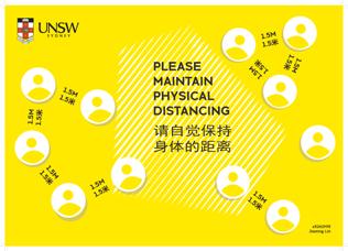
Combatting Covid:
- COVID Signage Awareness Internally and Externally on campus
- Intentionally chosen 3 spaces within the UNSW Mall which experience the most human traffic where COVID messaged will target mass audiences
Environmental Awareness:
- Sustainable materials (list materials - recycled steel, aluminium, timber, recycled vinyl)
- Inclusivity encouraged through multi-media signage including lighting for night time usage, enhancing safety
Increasing Brand Identity:
- Motif of DNA graphic repeated throughout the proposal, aiming to enhance the campus experience whilst establishing clear COVID physical distancing measures which are easy to digest
- Design of furniture and sheltered walkways mirror the aim of increasing brand identity whilst also creating clear paths of travel, aligning with the university’s identity both during the day and at night
Skills Developed:


INTERNSHIP
Design Office Experience:
Intern at landscape team of Huachengboyuan Construction Engineering Co., Ltd. as Student Landscape Architect 09/2022 - 12/2022 Hangzhou, China
Project 1: Landscape Improvement Scheme Design of Hebi City Rong Media Center in the City of Hebi
(General project assistance, site visit and analysis, rendering, 3D modelling and report preparation by using Photoshop, Illustrator, AutoCAD, Sketchup and InDesign)


Project 2: A Residential Landscape Design in the City of Hangzhou (Bubble diagrams, sketch design, hand-drawing skills, concept designs, materials research)
Limestone Paving
Bluestone Steppers
Blackbutt Decking
INTERNSHIP
Landscape Industry Work Experience: Randwick City’s Bushcare and Parkcare as Bushcare & Parkcare Program Member 03/2023 - 12/2023 Sydney, Australia
• Removing weeds and helping native plants grow.


https://www.randwick.nsw.gov.au/environment-and-sustainability/bushland/bushcare/bushcare-volunteers
• Planting natives plants and revegetating bare patches to increase the aesthetics and provide habitat for local fauna.
• Installing wooden sticks to stabilise slopes and prevent soil erosion
• Mulch garden beds and prune vegetation to maintain the native garden.
• Randwick Council has 15 Bushcare sites and 2 Parkcare sites guided by the Council’s Bushcare Officer. We go to which site is based on the Bushcare Calendar and weekly emails, and I have been to 9 sites already.