LANDSCAPE ARCHITECTURE PORTFOLIO
2019-2022
Hannah Jiaming Lin
Bachelor of Landscape Architecture (Hons) University of New South Wales

1
Hannah Jiaming Lin
Bachelor of Landscape Architecture (Hons)
The University of New South Wales, Australia
Tel: +86 13216182377 +61 0421866147
E-mail: jiaminglin7210@gmail.com 721042450@qq.com
WORKING EXPERIENCE & ACTIVITIES
2022 - Intern at Huachengboyuan Construction Engineering Co. Ltd., Hangzhou, China
PERSONAL
My passion for landscape architecture starts from very early. My father is an architect. When I was young, I liked to travel around with my father to see many different buildings and parks. He liked architecture, but I had some changes. I seemed to prefer beautiful outdoor scenery, a quiet park and a busy street. Those interesting and adventurous designs inspired my curiosity about landscape architecture. Some seemingly ordinary projects will be amazed when you find out what they really mean.
I like painting. I have a strong spatial imagination and a careful and rigorous attitude towards things. All these show that I am very suitable for the major of landscape. The studies in the university has given me more knowledge, skills and theories. I will continue to pursue and explore the sustainable development of human and the quality of public space.
Participated in projects, "Design Scheme For Environmental Improvement of Dapishan Scenic Area" and "Landscape Improvement Scheme Design of Hebi City Rong Media Center" in Hebi City, Henan Province, China. The main tasks for the intern landscape architect will be site survey and analysis, sketch design, predesign work and attending meetings with clients. Developed skills: designing, layouting, rendering, creating diagrams and translating by using Photoshop, Illustrator, AutoCAD, Sketchup and InDesign.
Student Member of AILA
Member of UNSW Chinese Student Association

EDUCATION
2015-2018 2019-Present
Dongfang High School, Hangzhou, Zhejiang, China (QCE International Education program)
The University of New South Wales, NSW, Australia
2 ABOUT ME
SKILLS Photoshop Sketchup Illustrator InDesign AutoCAD
TECHNICAL
VRay Enscape
STATEMENT
QGIS Procreate Microsoft Office Hand Drawing Model Making
ACKNOWLEDGEMENT OF COUNTRY


I acknowledge the Bidjigal People as the traditional custodians of the land where my campus is located. I pay my respect to the Elders of the past, present and future for they hold the values, culture, memories and hope of the Australian landscape.
I value their continuing connection to Country and profoundly appreciate their shared knowledge, allowing me to deepen my understanding of the land and become a better landscape architect.

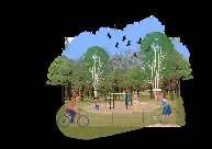
PEDAL SPIRIT

3 CONTENTS 01 02 03 04 05
AIR INTERDISCIPLINARY WORKS OTHER SKILLS
[4-11] [12-19] IMMERSE IN NATURE THE
[28-29] [20-27] [30-31]
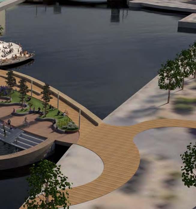
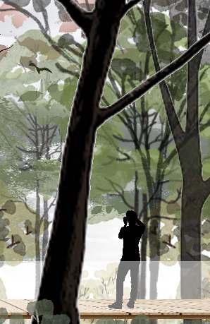
Copehagen has always been known for cycling, Cycling has always been a sport also a culture that Copehagen people like very much. Copehagen city center is Bisected by the Nyhavn Canal. The bridge will be designed for pedestrians and cyclists to strengthen the connection between the two sides of the river and become a city link and a landmark that inspires the world to choose cycling.


4
SPIRIT Courage-Exploreration-Innovation 01 Project Vision
with the space and facilities
the site
riding
and
and
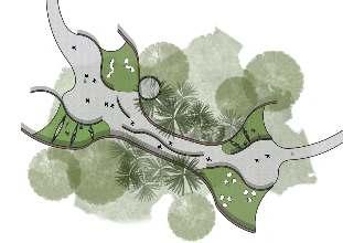
Project Principles · Riding accessibility - bicycles can reach every conrner · Touch the water · Complete supporting facilities · Embody the spirit of exploration, innovation and adventure · Sustainable development Location: Copenhagen, Denmark Project Background LAND2202 Studio 4: Design Detail: Resolution + Representation Term 2, Year 2, 2021
PEDAL
Interact
of
through
behavior, enrich people’s riding experience
cultivate people’s spirit of exploration
innovation.
Skills Developed:
5
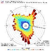
CIRCULATION ANALYSIS
COPENHAGEN
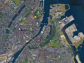
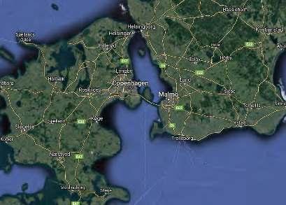
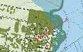
The design site is located in Copenhagen. The capital and most populous city of Denmark. Copenhagen is situated on the eastern coast of the island of Zealand; another portion of the city is located on Amager, and it is separated from Malmö, Sweden, by the strait of Øresund.
Cycling can not only save energy, it is conducive to the sustainable development of society, and can promote people's communication. It can also increase people's courage and cultivate a spirit of exploration and adventure.
COPENHAGEN CITY CENTER Bisected by the Nyhavn Canal

Consideration of connection points on both sides
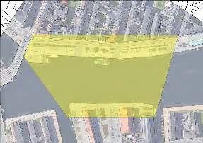
BRIDGE LOCATION
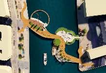
The shape of the site boundary is trapezoid. It’s next to Knippels Bridge and Inderhavnsbroen Bridge. And besides the rejuvenation area: A proposed active community hub.
From the circulation map, it can be seen that the bridge can connect the main roads on both sides of the river. It's easier for people to get to the lower left area of the bridge through the nearby Knippels bridge. The bridge is connected by diagonal lines.
6 SITE BROADER CONTEXT
To Torden Skjolds Gade To Badsmandsstrade Havnegade Havnebussen To Bridge Northeastern N 1:500@A1 To Bridge Southwestern ToBridge Northeastern ToBridgeSoutheastern ToStrandgade Strandgade TordenSkjoldsGade To Peder Skrams Gade PederSkramsGade Havnebussen COMMERCIALSPACE CREATIVE&ARTISTICRETAIL
SITE SURVEY & CONCEPT COPENHAGEN
Residential Area A large
of
flow to
center Industrial area
amount
people
the city
Gammelholm
City Center
Christianshavn
Gammelholm
Christianshavn
MASTERPLAN
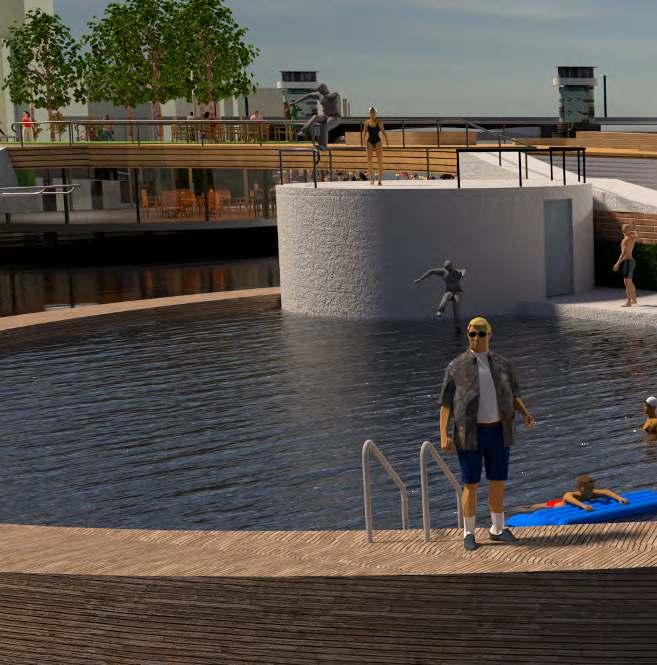
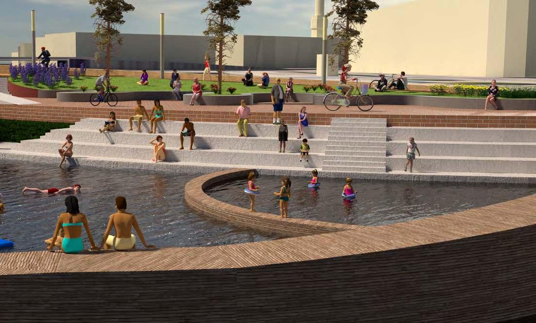
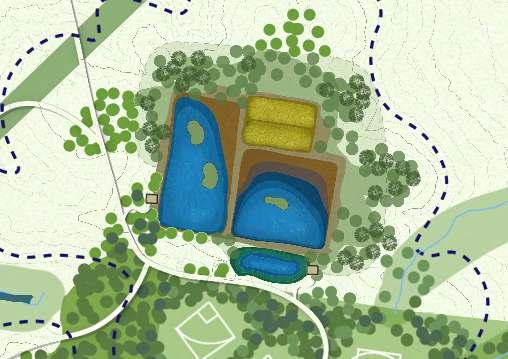
SWIMMING AREA
-180cm deep adult area
-90cm deep junior area -250cm deep jumping area
-Changing room with a rooftop jumping platform
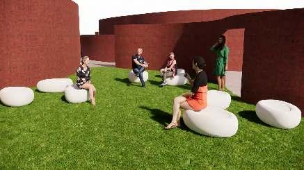
CORRIDOR, LAWN SITTING AREA
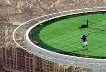
EXTREME SPORT AREA
-Bike ramp
-Universal design, Wheelchair accessibility, 1in14 ramp -Curved Wallride with mound, standing place -Benches
-Seating stair space, 1in14 ramp, stair
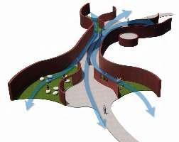
The design required that having a 3.25m clearance to water, 15m width sea route for boats to pass through. So my bridge gradually rises with a slope of less than 1 to 20. However, the three spaces I designed are all flat. This naturally forms some sinking space. These spaces are backed by the main path of the bridge, which making some refuges.
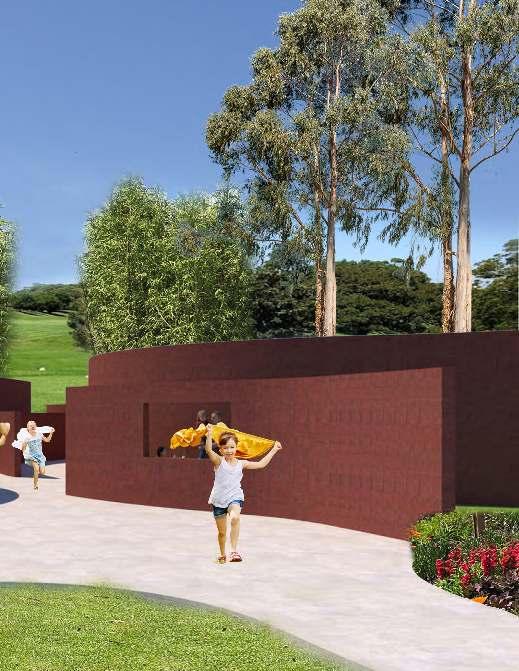
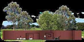
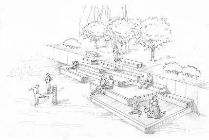
WATERFRONT AMPHITHEATER
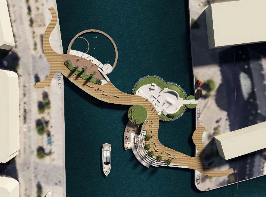
7 N 1:300@A1
GREEN
CAFE, ROOFTOP SEATING SPACE, HERITAGE LOOKOUT MAIN PATH FOR HIKERS & BIKERS
3.25m CLEARANCE TO WATER,15m WIDTH FOR BOATS TO PASS UNDER
BICYCLE RACKS
AND
RUBBISH
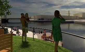
BINS Pedestrian bridge can be a place to meet, to socialize, to watch, and to gather.
HERITAGE LOOKOUT
WATERFRONT AMPHITHEATER
BY
NIGHT:
Waterfront amphitheater can be used as a performance platform at night. Provide performance space for Musicians, street performers.

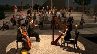
BY

DAY:
Waterfront amphitheater can be used as a waterfront platform during the day time. Providing people a place to playwater.


8
GREY IRONBARK DECK BRICK FLOORINGCONCRETE SEATING STAIR
MASS PLANTING, KIKUYU GRASS
CONCRETE WALL
HANDRAIL TYPE FOR SPORTING
The waterfront amphitheater is 300mm higher than the surface of the water, it’s a space very close to water. It’s 2.5m lower than the surface of the bridge. It’s a relatively quiet space.


9
PAINTED STEEL HANDRAIL
TIMBER DANISH HIBISCUS FLOWER
NORDIC PINE TREE
DANISH CAMPANULA FLOWER CONCRETE CIRCULAR SEATING
SITTING SPACE WATERFRONT AMPHITHEATER EXTREME SPORT AREA
LAWN
10 TF1 SW1 SW3 SW2 PV1 PV1 PV1 PV2 PV5 PV3 PV3 W2 W2 W2 ST3 PV3 PV5 W2 WATER WATER E2 E2 E1 E1 E1 W1 W1 WATER WATER ST2 ST1 PV1 BI1 BR1 SR1 SR1 SR1 SR1 SR1 SR1 SR1 SR1 HR1 TI1 TI1 TI1 SE1 SE1 SE1 PV1 PV1 PV1 PV1 TF1 TF1 TF1 TF1 TF1 TF1 PV3 PV3 PV3 PV3 TF1 PV3 PV3 PV5 PV3 PV5 PV5 PV4 TF1 PV3 PV3 PV3 PV3 WATER WATER WATER PV3 BI1 BR1 BI1 BR1 BI1 BR1 PV1 SR1 SR1 SR1 SR1 SR1 SR1 SR1 SR1 SR1 SE1 SR1 SR1 SR1 SR1 SR1 W2 TB1 TB1 TB1 TB1 TB1 TB1 SW4 HR1 HR1 HR1 HR1 HR1 HR1 HR1 HR1 TI1 TI1 TI1 TI1 TI1 TI1 TI1 TI1 TI1 TI1 HI1 HI1 HI1 HI1 ST4 ST5 SR1 SR1 SR1 SR1 SR1 SR1 SR1 SR1 SR1 SR1 SR1 SR1 SR1 SR1 HR1 TG1 TG1 TG1 TG1 TG1 HR2 HR2 SE1 SE1 SE1 SE1 SE1 SE2 SE2 SE2 SE2 SE2 SE2 TR1 Scale: 1:250 3750 5000 2500 1250 DESIGN DOCUMENTATION DOCUMENTATION PLANS Set Out and Grading Plan Surface Finishes Plan Planting Plan HATCH/SYMBOLCODEDESCRIPTIONMATERIALS PV1WOOD PAVINGSCOTS PINE TIMBER BATTENS PAVEMENT SURF (100x35mm) WITH JOIST SPACING 450-500mm, CRETE, REINFORCEMENT, DGB20 SUBBASE PV2DENMARK STANDARD BRICK 228x108x54mm BRICK PAVING SURFACE WITH HORIZONTALAND VERTICAL MORTAR JOINTS 25MPACONCRETE, REINFORCEMENT, DGB20 PV3100mm DEPTH CONCRETE PAVEMENT 25MPACONCRETE, REINFORCEMENT, DGB20 PV4GRANITE PAVINGASHLAR PATTERN GRANITE PAVING SURFACE, CRETE, REINFORCEMENT, DGB20 SUBBASE PV5PRECAST CONCRETEPRECAST 25MPACONCRETE BLOCK
FORCEMENT, DGB20 SUBBASE W1 1500mm WIDTH WOOD CLAD SEATING WALLWITH CONCRETE CORE SCOTS PINE TIMBER BATTENS PAVEMENT CLAD WITH JOIST SPACING 400-450mm,
CONCRETE,
W2 1500mm WIDTH WOOD CLAD WALKING WALL WITH CONCRETE CORE SCOTS PINE TIMBER BATTENS PAVEMENT CLAD WITH JOIST SPACING
REFER SPECIFICATION NOTES. ST1-5INSITU CONCRETE STAIRSCONTRAST NOSING, INSITU 25MPACONCRETE REINFORCEMENT, DGB20 SUBBASE. REFER SPECIFICATION NOTES. SE1 1200x620mm TIMBER SEATS FORAGROUP SCOTS PINE TIMBER BATTENS PAVEMENT SURF (100x35mm) WITH FIXED TOANGLE STEEL FRAME LOW. 25MPACONCRETE, REINFORCEMENT, SE2 650x600mm TIMBER SEATS FOR INDIVIDUAL SCOTS PINE TIMBER BATTENS PAVEMENT SURF (100x35mm) WITH FIXED TOANGLE STEEL FRAME LOW. 25MPACONCRETE, REINFORCEMENT, MATERIALS AND MATERIALS AND SYMBOL CODEDESCRIPTION MATERIALS TI1TACTILE INDICATER50mm DIAMETER 316 GRADE DTAC SOLID STAINLESS TACTILES WITH SLIPRESISTANT ENGRAVED (SOLID), SPIKE MOUNTING. TO MATCH. REFER TO DETAILSAND SPECIFICA HR2HORIZONTALDIRECTION PAINTED STEELWHITE HANDRAILWITH NET 100mm DIAMETER PAINTED WHITE STEELHANDRAIL. HANDRAILS LONGER THAN 2500mm INSTALL BR1BIKE RACK FOR FIVE BICYCLES TO PARK STAINLESS STEELBIKE RACK FOR FIVE BICYCLES DETAILSAND SPECIFICATION NOTES.2550x290x700mm BI1THREE RUBBISH BIN SETTHREE STAINLESS STEELRUBBISH BIN SET TG1SOLID CAST-IRON TREE GRATESOLID CAST-IRON TREE GRATE. BOTH THE TREE BE1CONCRETE BENCH WITH CONCRETE 25MPACONCRETE BLOCK WITH REINFORCEMENT 3000x400x150mm, CONCRETE BLOCK SEAT SUPPOR TB1WOOD COFFEE DINING TABLE SETTING NORDIC HARDWOOD TABLE: 750mm HEIGHT, SR13000mm HEIGHT STREET LIGHT ALUMINIUMALLOYCYLINDER, GLASS LAMPSHADE PLANTS (REFER TO PLANTING PLAN) 75mm MULCH LAYER PLANTS (REFER TO PLANTING PLAN) SW3MASS PLANTINGIMPORTED SOIL 75mm MULCH LAYER PLANTS (REFER TO PLANTING PLAN) SW4MASS PLANTINGHEDGE, IMPORTED SOIL, 75mm MULCH LAYER (REFER TO PLANTING PLAN) TF1TURF GRASS (REFER TO PLANTING PLAN) TR1 PROPOSED TREE TREE (REFER TO PLANTING PLAN) MATERIALS AND FINISHES PLAN
1500x450x120mm,
25MPA
FORCEMENT, DGB20 SUBBASE
400-450mm, 25MPACONCRETE, FORCEMENT, DGB20 SUBBASE E1HOT DIPPED GALVANISED STEEL EDGE 10mm WIDTH HOT DIPPED GALVANISED STEEL LENGTHAS SHOWN, GAL ROD 15mm DIAMETER LENGTH WELDED TO STEEL EDGEAT 500mm E2 SANDSTONE SEATING EDGE SANDSTONE, 25MPAINSITU CONCRETE SEATING REINFORCEMENT, DGB20 SUBBASE.
11 UNITS DEPTH (mm) LENGTH (mm) WIDTH (mm) 1500 450 50 50 1200 900 450 450 50 600 A C D D B D D A A D B C C A A C D D B D B D D A A D B D C A A C D GRANITE PAVING 1 PLAN Scale: 1:20 150 150 900 600 500 CONCRETE PAVEMENT REFER TO FOR ADJACENT MATERIALS SET OUT PAVERS AT 90° PAVEMENT 400mm AT LOCATIONS INDICATED. CLOSURE UNITS VARY DETERMINED BY PATTERN. NON-STANDARD CUT GP(F) GP(F) 4 COURSES WIDE COURSES @ 450 WIDE 1 MODULE GP:GRANITE PAVING GP(F): GRANITE PAVING FACETTED NOTE: 1.1-3mm GAP REQUIRED BETWEEN PAVERS. 2.50MM THICK PAVERS WILL BE REQUIRED IN DISTINCTIVE PLACES AS SPECIFIED GP GP NOTE: ALL DIMENSIONS IN MILLIMETRES UNLESS OTHERWISE STATED PV4 DETAILS GRANITE PAVING: PLAN DETAILS GRANITE PAVING: SECTION GRANITE PAVING 1 SECTION Scale: 1:10 30 50 MATERIALS AND FINISHES PLANS ENGINEER'S SPECIFICATION COMPACTED SUBBASE TO 30mm SAND BED JOINTS, JOINTS AS PER CIVIL ENGINEER'S DOCUMENTATION CONCRETE WITH REINFORCEMENT. FOOTING DRAWINGS FOR REINFORCEMENT DETAILS. ASHLAR PATTERN GRANITE PAVING PV4 DETAILS GRANITE PAVING: AXONOMETRIC GRANITE PAVING 1 AXONOMETRIC CONCRETE PAVING GRANITE PAVING WATER DETAILS STAIR TRANSITION: PLAN STAIR TRANSITION 1 PLAN Scale: 1:20 TYP.300 300 600 300 300 600 97 50 15 ST4 TIMBER BATTENS PAVEMENT REFER TO MATERIALS AND MATERIALS PAINTED STEEL CHS HANDRAIL EPOXY FIXED TO SURFACE MATERIAL MATERIALS AND FINISHES PLANS FOR ADJACENT MATERIALS TURF PAVING REFER TO MATERIALS AND FINISHES PLANS FOR ADJACENT STONE PAVED CONTRAST NOSING NOTE: ALL DIMENSIONS IN MILLIMETRES UNLESS OTHERWISE STATED 23 1 DETAILS STAIR TRANSITION: SECTION 1 SECTION Scale: 1:20 R100 300 1020 50 200 1270 100 TYP.300 TYP.150 CONCRETE AND REINFORCING TO CENTRALLY LOCATED POST TO MATCH. PAINTED STEEL COVER PLATE 100mm COVER FOR HAND RAIL FIXING. ENGINEERS. EPOXY FIXED TO SURFACE MATERIAL TACTILE SURFACE INDICATORS 1 PLAN Scale: 1:5 50 50 50 50 SPIKE MOUNTING TACTILES WITH SLIP RESISTANT ENGRAVED SIDE ST4 TI1 TACTILE INDICATORS 15mm SETBACK ENGINEER'S SPECIFICATION NOTE: ALL DIMENSIONS IN MILLIMETRES UNLESS OTHERWISE STATED STAIR TRANSITION 1 AXONOMETRIC ST4 TACTILE INDICATOR TACTILE INDICATOR PAINTED STEEL HANDRAIL NOSING CONCRETE PAVING CONCRETE PAVING DETAILS SEAT FOR A GROUP AND INDIVIDUAL: PLAN SEAT FOR GROUP 1 PLAN Scale: 1:10 SEATS FOR INDIVIDUAL 2 PLAN Scale: 1:10 600 520 1200 TYP.100 TYP.10 650 520 TYP.100 TYP.10 620 SCOTS PINE TIMBER BATTENS PAVEMENT SURFACE (100x35mm) WITH FIXED TO ANGLE STEEL FRAME FROM BELOW. 20mm RADIUS TO ALL CORNER EDGES SURFACE (100x35mm) WITH FIXED TO ANGLE STEEL FRAME FROM BELOW. 20mm RADIUS TO ALL CORNER EDGES ANGLE STEEL FRAME ANGLE STEEL FRAME CONCRETE SEATING WALL LENGTH OF CONCRETE LENGTH OF CONCRETE SEATING WALL REFER TO PLAN NOTE: ALL DIMENSIONS IN MILLIMETRES UNLESS OTHERWISE STATED SE1 SE2 R1000 28 1 28 1 SEATS FOR INDIVIDUAL 2 SECTION Scale: 1:10 SEAT FOR GROUP 1 SECTION Scale: 1:10 50 370 460 430 100 90 103° 820 620 R20 64° 96° R20 520 80° R20 90 R20 470 90 90 650 370 100 71° 109° 50 10 FLUSH MOUNT/COUNTERSUNK STAINLESS CONCRETE CORE WITH REINFORCEMENT. FOOTING INDICATIVE ONLY. REFER TO STRUCTURAL ENGINEER'S DRAWINGS FOR REINFORCEMENT DETAILS. SCOTS PINE TIMBER BATTENS PAVEMENT SURFACE (100x35mm) WITH FIXED TO ANGLE STEEL FRAME FROM BELOW. 20mm RADIUS TO ALL CORNER EDGES 35 10 50 35 10 100 FLUSH MOUNT/COUNTERSUNK STAINLESS STEEL/GALVANISED SURFACE FIXINGS TO MANUFACTURERS SPECIFICATION INDICATIVE ONLY. REFER TO STRUCTURAL ENGINEER'S DRAWINGS FOR REINFORCEMENT DETAILS. SCOTS PINE TIMBER BATTENS PAVEMENT SURFACE (100x35mm) WITH FIXED TO ANGLE STEEL FRAME FROM BELOW. 20mm RADIUS TO ALL CORNER EDGES TIMBER BATTENS PAVEMENT 100 150 TIMBER BATTENS PAVEMENT ANGLE STEEL FRAME SE1 COMPACTED SUBGRADE TO ENGINEER'S SPECIFICATION COMPACTED SUBBASE TO ENGINEER'S SPECIFICATION COMPACTED SUBBASE TO ENGINEER'S SPECIFICATION NOTE: ALL DIMENSIONS IN MILLIMETRES UNLESS OTHERWISE STATED SE2 DETAILS-SEAT FOR A GROUP AND INDIVIDUAL: SECTION SEATS FOR INDIVIDUAL 2 AXONOMETRIC SEAT FOR A GROUP 1 AXONOMETRIC CONCRETE CONCRETE TIMBER TIMBER CONCRETE DIMENSIONS JOINTS/FIXTUREFINISHESMISC SURFACE 25MPACONAS SHOWNREFER TO CIVIL ENGINEERS DOCUMENTATION VARNISH12mm THICK INVOLVED, SUBBASE AS SHOWNREFER TO CIVIL ENGINEERS DOCUMENTATION EXPOSEDAGGREGATE SUBBASEAS SHOWNREFER TO CIVIL ENGINEERS DOCUMENTATION FLOATAND TROWELED SURFACE, 25MPACON- AS SHOWNREFER TO CIVIL ENGINEERS DOCUMENTATION EXPOSEDAGGREGATE 1500x450x120mm, REIN- AS SHOWNREFER TO CIVIL ENGINEERS DOCUMENTATION POLISHED SURFACECLAD (140x26mm) CONCRETE, REINAS SHOWNREFER TO CIVIL ENGINEERS DOCUMENTATION VARNISHCLAD (140x26mm) CONCRETE, REINAS SHOWNREFER TO CIVIL ENGINEERS DOCUMENTATION VARNISHPLATE, DIAMETER X 500mm MIN. INTERVAL AS SHOWNREFER TO CIVIL ENGINEERS DOCUMENTATION POLISHED SURFACESEATING EDGE, DETAILSAND AS SHOWNREFER TO CIVIL ENGINEERS DOCUMENTATION POLISHED SURFACESURFACE, DETAILSAND AS SHOWNREFER TO CIVIL ENGINEERS DOCUMENTATION EXPOSEDAGGREGATE SURFACE FRAME FROM BEDGB20 SUBBASE AS SHOWNREFER TO CIVIL ENGINEERS DOCUMENTATION VARNISHSURFACE FRAME FROM BEDGB20 SUBBASE AS SHOWNREFER TO CIVIL ENGINEERS DOCUMENTATION VARNISHFINISHES SCHEDULE FINISHES SCHEDULE DIMENSIONS JOINTS/FIXTUREFINISHESMISC STAINLESS STEELWARNING SIDE GROOVES. BRASS AS SHOWN-BRASS (SOLID)SPECIFICATION NOTES. HANDRAIL. 900mm HEIGHT CENTRALLYLOCATED POST AS SHOWN-PAINTED STEELBICYCLES TO PARK. REFER TO NOTES.2550x290x700mm AS SHOWN-STAINLESS STEEL SET1440x520x900mm-STAINLESS STEEL TREE GRATEAND THE INNER- 1000mm DIAMETER-POLISHED REINFORCEMENT: 3000x400x450mm-POLISHED 1200mm DIAMETER 1900x1900x950mm-VARNISHLAMPSHADE3000mm HEIGHT, -POLISHED INFORMATION AND SCHEDULE FOR MORE INFORMATION AS SHOWN--REFER TO PLANTING PLAN AND SCHEDULE FOR MORE INFORMATION AS SHOWN--REFER TO PLANTING PLAN AND SCHEDULE FOR MORE INFORMATION AS SHOWN--REFER TO PLANTING PLAN AND SCHEDULE FOR MORE INFORMATION AS SHOWN--REFER TO PLANTING PLAN AND SCHEDULE FOR MORE INFORMATION DETAILS-GRANITE PAVING (PV4) DETAILS-STAIR TRANSITION (ST4) DETAILS-SEAT FOR A GROUP AND INDIVIDUAL (SE1&2)
STAIR TRANSITION: AXONOMETRIC
DETAILS
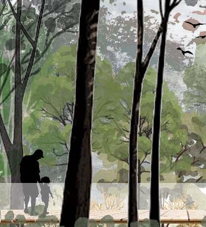
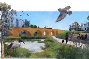
IMMERSE IN NATURE
Location
Marsden Park North (Angus), NSW, Australia
Project Background


Studio 5 and 6 is combined into one big project, which firstly work on the analysis of the Commons, the crit ical landscape systems that form and inform Angus and the scenario planning (Studio 5) and then create a Landscape Masterplan for Angus (Studio 6).
The site is located in Angus in Western Sydney, where it will transform into a denser human settlement over the next 20-30 years, and with more frequent flood risks.
Project Vision
Angus is going to address the need for housing and flooding issue in western sydney by using flood resilient design, as well as establishing a sustainable angus community with a good ecosystem.
Project Principles
1.Mitigation and adaptation for probable flood in Angus ("Very large flood" condition as well as "Biggest flood possible" condition) by using flood resilient design
2.Reestablish a mixed-use community, medium and high density residential housing area with varied infrastructures and recreational spaces
3.Create a multi-functional transport infrastructure with a walkable neighborhood
4.Provide a range of different recreational spaces for active and passive recreation for a range of user groups and communities
5.Create a good ecosystem of Angus through interactions and exchanges across heterogeneous landscapes to increase high biodiversity value and provide habitat for animals.
Skills Developed:
12
LAND2311 Studio 5: Site Planning: Landscape Systems and Performance Term 1, Year 3, 2022 LAND2312 Studio 6: Design With a Complex Program Term 2, Year 3, 2022 02


13
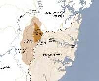
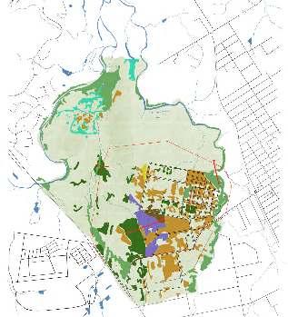
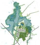
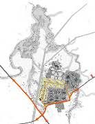
METROPOLITAN SYDNEY CONTEXT
Castlereagh Swamp Woodland:
Shale Plains Woodland:
The Shale Plains Woodland within the study area is part of the Endangered Ecological Community Cumberland Plain Woodland. Due to the varying levels of historical disturbance, the community is consists of a mixture of good and poor condition vegetation.
Cover: 132.3 ha
Shale Gravel Transition Forest:
It is a critically endangered ecological commu nity under the EPBC Act 1999. Shale Gravel Transition Forest grades into Shale Plains Woodland as alluvial and ironstone influences decline.
Cover: 65.8 ha
The eastern creek catchment is feeded by many sub-catchments.

(adapted from source: State of The Waterways Management Plan-Eastern Creek 2005)
Cooks River Castlereagh Ironbark Forest:
It is an endangered ecological community listed under the BC Act 2016. It primarily occurs on clay soils derived from Tertiary Alluvium, or on shale soils adjacent to the boundary with Tertiary Alluvium.
Cover: 24.5 ha
Source: Biodiversity and Riparian Corridors Assessment 2018
VEGETATION ANALYSIS
It is an endangered ecological community listed under the BC Act. A low woodland with not well developed shrub layer and mostly made up of young paperbark trees.
Cover: 2.2 ha
Alluvial Woodland:
The Alluvial Woodland within the study area is part of the endangered ecological community River-Flat Eucalypt Forest. It was associated with the drainage lines within the study area. Cover: 83.8 ha
Castlereagh Scribbly Gum Woodland:
An endangered ecological community under the BC Act 2016. It occurred on the higher ground in the noncertified conservation area.
Cover: 7.8 ha
Freshwater wetland:
An endangered ecological community under the BC Act. The wetland habitat is consisted of stand ing water and associated with the former Riverstone Meatworks ponds.
Cover: 20.7 ha
Alluvial Woodland (EEC):
Tree stratum: Eucalyptus tereticornis (Forest Red Gum), Casuarina glauca (Swamp Oak)
Shrub stratum: Bursaria spinosa (Native Blackthorn), Lycium ferocissimum (African Boxthorn)
Ground stratum: a mixture of native and exotic grasses and herbs
VEGETATION AND LANDSCAPE STRUCTURE
Bird Habitat/ Wetland: Meadow or reedland with dominant species such as Ludwigia peploides subsp. montevidensis, Triglochin procera and Philydrum lanuginosum
14
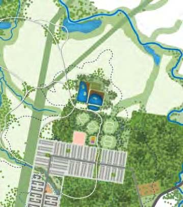
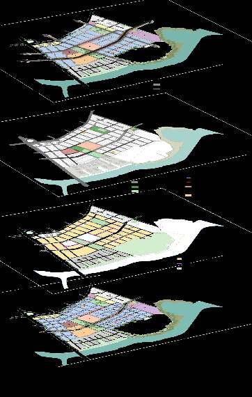
Mittagong Tertiary Alluvium EXISTING KEY AREA PLAN EXISTING KEY AREA AXONOMETRIC SITE ANALYSIS (STUDIO 5) CONTEXT
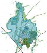
FLOOD RISK ANALYSIS HOW ANGU SYSTEM MIGHT PERFORM OVER TIME AS THE FLOOD REGIME SHIFTS? The blue area shows the flood prone area with a 98% high chance of happening in an 80 year lifetime, it will reach about 15 meters above the sea levels and part of the residential area will be flooded. The blue area shows the flood prone area with a 15% low chance of happening in an 80 year lifetime and it will reach about 20 meters above the sea levels. Therefore we can see more residential area will be flooded.
SECTION DD SCALE: 1:1000 @ A1
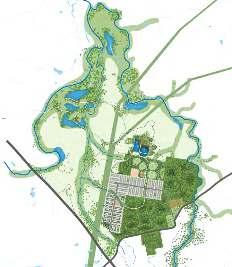
VEGETATION ANALYSIS VEGETATION COMMUNITIES D D A A Site CBD ANGUS MARSDEN PARK EASTERN CREEK SOUTH CREEK WINDSOR RICHMONDRD RIVERSTONE SITE CONTEXT @1:10,000 (Teamwork with Eric Chen, this diagram was drawn by me) (Teamwork with Eric Chen, this diagram was drawn by me)
PROJECTIVE
FUTURE SCENARIO PLANNING
NEXT
NEXT
Shale Gravel Transition Forest (EEC):

Tree stratum: Eucalyptus fibrosa, Melaleuca decora
Shrub stratum: Bursaria spinosa, Daviesia ulicifolia
Ground stratum: Themeda australis, Opercularia diphylla
Shale Plains Woodland (EEC):
Dominant tree canopy: Eucalyptus moluccana (Grey Box), Eucalyptus tereticornis (Forest Red Gum)
Shrub stratum: Bursaria spinosa (Native Blackthorn), Grevillea juniperina (Juniper Grevillea)
Groundcover: a mixture of native and exotic grasses and herbs
VEGETATION AND LANDSCAPE STRUCTURE
Cooks River Castlereagh Ironbark Forest (EEC):
Dominant tree canopy: Eucalyptus fibrosa and Melaleuca decora
Shrub stratum: Daviesia ulicifolia, Grevillea juniperina.
Groundcover: Themeda australis, Opercularia diphylla
Castlereagh Scribbly Gum
Woodland (EEC):
(Teamwork with Eric Chen, this diagram was drawn by me) (Teamwork with Eric Chen, this diagram was drawn by me)
Dominant tree canopy: Eucalyptus parramattensis and Melaleuca decora
Shrub stratum: Banksia spinulosa, Melaleuca nodosa
Ground stratum: Entolasia stricta, Themeda australis
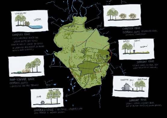
15 EDGE ANALYSIS
Increasing housing supply to meet the needs of a growing and changing population. The density of the residential houses in Angus will be increased with from one to two storeys high.
DESIGN IDEAS
5
The residential area will be located in relatively higher level which will above 20 meters contour line It is safe to the flooding with a 15% low chance of happening in an 80 year lifetime. Increasing tree canopy to provide more ecological living environment Wetland can contain and hold large amount of water which will benefit to resist flooding. Bird Protection with open and grassy understorey, with scattered shrubs. The grazing lands with a scattered overstorey present above exotic grassland Abundant logs and fallen timber are important habitat components for birds. In autumn and winter, migratory birds may live in there, and may join mixed flocks of small insectivorous birds. In future, with the increase of population, the playground will expand in more sustainable way with using of natural materials. Baseball field for recreation Creating a sustainable soccer grass field or football lawn field Increasing more housing supply to meet the needs of a more growing and changing population. The density of the residential houses in Angus will be increased with from two to three storeys high.
YEARS
20
35
FLOODING IN A 98% HIGH CHANCE OF HAPPENING IN AN 80 YEAR LIFETIME, IT WILL REACH ABOUT 15 METERS ABOVE THE SEA LEVELS. FLOODING IN A 15% LOW CHANCE OF HAPPENING IN AN 80 YEAR LIFETIME AND IT WILL REACH ABOUT 20 METERS ABOVE THE SEA LEVELS.
YEARS NEXT
YEARS
VEGETATION ANALYSIS
Wianamatta Shale Hawkesbury Sandstone Mittagong Formation Tertiary Alluvium Holocene Alluvium
SECTION AA
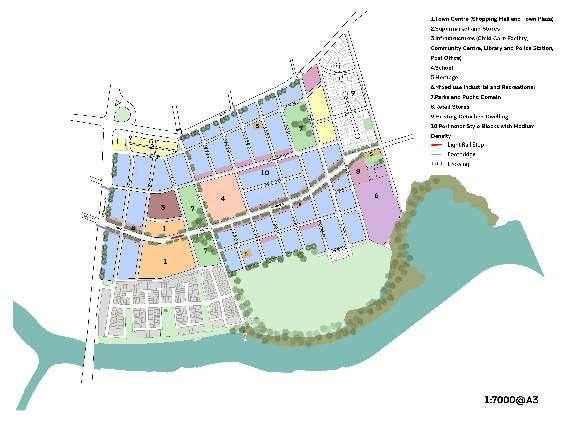
1.Medium Density Residential Area Inside of the "Very large flood medium chance" condition 2.High Density Residential Area Inside of the "Biggest flood possible extremely low chance" condition
Centre Including Child Care Facility, community library and police station, Post office
Local Drainage Wetlands as a nature-based solution for improving flood resilience. The drainage systems capture and treat stormwater runoff and prevent urban flooding on the catchment area. Park Passive Recreation Areas: Including places to sit and enjoy the water and environment, areas to meet and picnic, small events and informal games 5.Playground Active Recreation Areas: Grounds should be flood-resistant appropriate facilities. Provide some fitness equipments for the residents
(walking,
DETAILED DESIGN
PRINCIPLE 1
Mitigation and adaptation for probable flood in Angus ("Very large flood" condition as well as "Biggest flood possible" condition) by using flood resilient design
Seasonal Changes
I proposed some ephemeral wetland ponds near the existing watercourse, due to the retention capacity of the ponds, they can effectively mitigate flooding by temporarily holding water during the rain season and usual time.
Dry season
Rain season
The steeper the slope, the faster the stream flows, water flows slowly when it reaches a curve and this might cause a flooding, water flows quickly when it reaches a straight watercourse.
I proposed the high density residential area above the "Biggest flood possible" flood line and a bit modulatation of contour line.
Flood period
The blue area shows the flood prone in "Very large flood - medium chance" condition, In Marsden Park, a flood this size has a 55% chance of happening in an 80-year lifetime. This is also referred to as a 1 in 100 chance per year flood.
(NSW State Emergency Service Flooding Map 2021)
Flood period
The blue area shows the flood prone in "Biggest flood possible - extremely low chance" condition, in Marsden Park, a flood this size has less than a 0.1% chance of happening in an 80-year lifetime. This is the largest possible flood in the HawkesburyNepean Valley, also known as the probable maximum flood (PMF).
1:10,000 @A1 GarfieldRdW RichmondRd South Creek Eastern
Marsden Creek 1 2 3 4 5 6 7 8 9 10 11 12 13 14
Powerlines
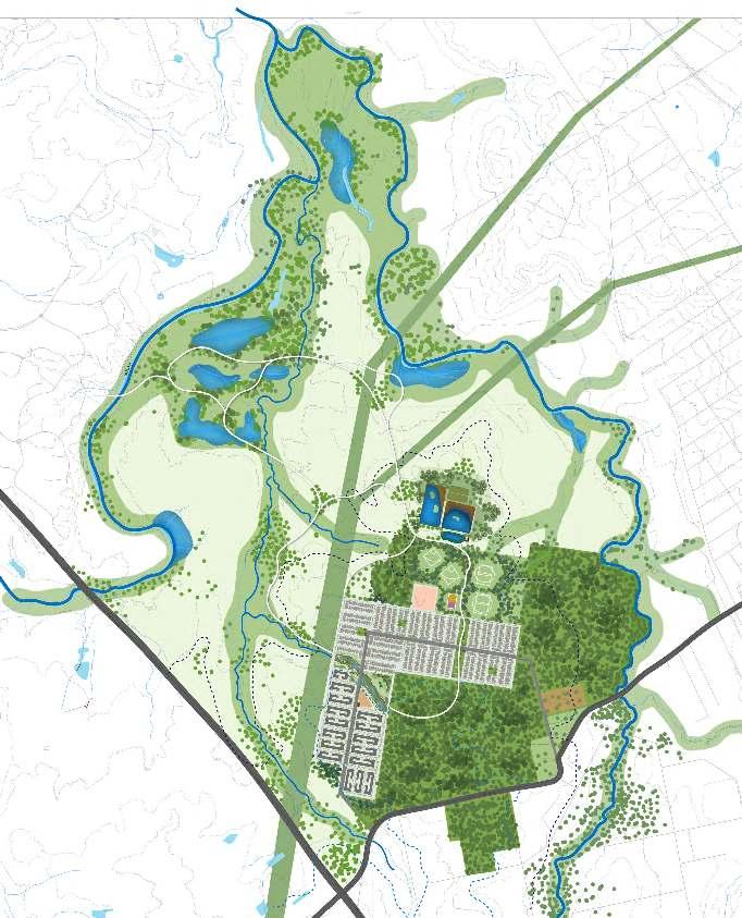
LEGEND MASTERPLAN MASTERPLAN (STUDIO 6)
Creek
3.Local
4.Infrastructure
6.School 7.Riverstone cemetery 8.Environmental conservation 9.Bird habitat 10.Wetland park 11.Boardwalk
running, cycling) 12.Linear park 13.Pocket park 14.Farmland/Rural landscape Focus Area Boundary
Very large flood - medium chance: In Marsden Park, a flood this size has a 55% chance of happening in an 80-year lifetime. This is also referred to as a 1 in 100 chance per year flood. Biggest flood possible - extremely low chance: In Marsden Park, a flood this size has less than a 0.1% chance of happening in an 80-year lifetime. This is the largest possible flood in the Hawkesbury-Nepean Valley, also known as the probable maximum flood (PMF).
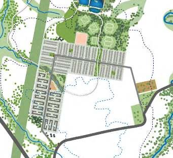
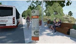
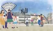
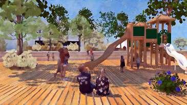
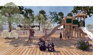
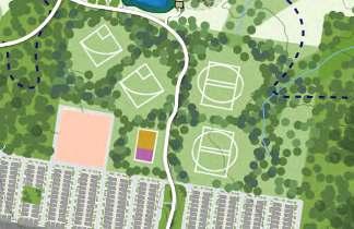
17 1 High density residential area street 2 Medium density residential area street 3 School 1 2 3 4 5 6 6 Playground 4 Riverstone cemetery 5 Masjid in local center area Reestablish a mixed-use community, medium and high density residential housing area with varied infrastructures PRINCIPLE 2 PRINCIPLE 3 Circulation diagram To Riverstone Railway Station Primary Road Secondary Road Tertiary Road Create a multi-functional transport infrastructure with a walkable neighborhood Riverstone railway station Bus stop TRANSPORT INFRASTRUCTURE Bus Stop (adapted from Jiaming Lin, 2022 LAND2311) WALKABLE NEIGHBORHOOD Boardwalks are the perfect solution for linking buildings or popular destinations Boardwalk in wetland park Boardwalk in urban drainage Circulation diagram Connect to Windsor Downs Boardwalk (walking, running, cycling) (adapted from Jiaming Lin, A2, 2022 LAND2312)
PASSIVE RECREATION
ACTIVE RECREATION
Active Recreation Areas: Grounds will be floodresistant appropriate facilities. Provide some fitness equipments for the residents such as a sports field.
18 2 1 3 4 5 6 7 2
Passive
Including
to sit and enjoy the water
areas
meet
picnic,
park LEGEND 1.Low Density Residential Area (inside of the "Very large flood medium chance" condition) 2.Medium Density Residential Area(inside of the "Biggest flood possible extremely low chance" condition) 3.Local Centre(Child Care Facility, community library and police station, Post office) 4.Infrastructure Local Drainage (Wetlands as a nature-based solution for improving flood resilience. The drainage systems capture and treat stormwater runoff and prevent urban flooding on the catchment area.) 5.Park (Passive Recreation Areas: Including places to sit and enjoy the water and environment, areas to meet and picnic, small events and informal games) 6.Playground (Active Recreation Areas: Grounds should be flood-resistant appropriate facilities. Provide some fitness equipments for the residents) 7.AmphitheaterArea Detailed plan 1:1000 @A3 Provide a
of different recreational
and
recreation for a
of user
Active Recreation Areas/Sports Field School
Recreation Areas:
places
and environment,
to
and
small events and informal games such as a
range
spaces for active
passive
range
groups and communities
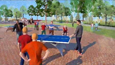
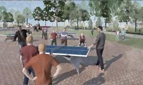
PRINCIPLE 4 Outdoor ping pong tables in sports field Playground
13.Climate
3.Good
Relevant SDGs: 11.Sustainable cities and communities –because the recreation area make communities inclusive, safe, resilient and sustainable Relevant SDGs:
action - Urban drainage systems capture and treat stormwater runoff and prevent urban flooding
health and well-being –because safe and secure housing is important to well-being;
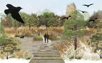
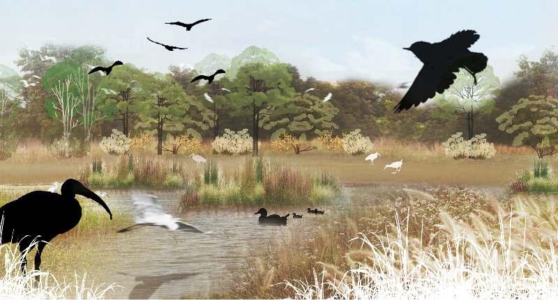
BIRDS HABITAT Catchment

LEGEND
1.Wetland
Primary treatment zone
2.Large pond in the east Secondary treatment zone, waterbody buffer (common waterbird foraging area)
3.Large pond in the west Third treatment zone, waterbody buffer (common waterbird foraging area)
The two large ponds provide a wide expanse of approximately 7 ha of open water
4.The two smaller vegetated ponds in the north
The two vegetated ponds were dominated by bullrushes (Typha spp.). The four ponds provides suitable breeding and foraging habitat for a number of migratory and local native bird species.
5.Mudflat Migratory shorebird foraging area
6.Floating Wetland Island
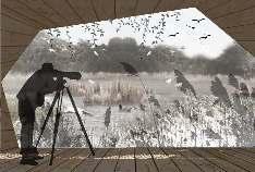
7.Bird watching shelters access through small winding trails
8.Boardwalk (walking, runing, cycling)
19 Latham's Snipe Black-tailed Godwit Common Greenshank Sharp-tailed Sandpiper Migratory bird
Underground rainwater pipe Guide the rainwater from the nearby highland residential development through underground rainwater pipe system to fill the ponds during the dry season. 1 2 3 7 4 7 5 5 6 BUFFER BUFFER 9 100m 100m
Bird watching shelter
Create a good ecosystem of Angus through interactions and exchanges across heterogeneous landscapes to increase high biodiversity value and provide habitat for animals.
Floating Wetland Island Design Inspiration: Diagram depicting shorebird disturbance buffer scenario Waterbody (common waterbird foraging area) Waterbody (common waterbird foraging area) (migratory shorebird foraging area) aquatic habitat creation water quality treatment terrestrial habitat creation (EcologicalAustralia 2018) (BioHaven® Floating Islands –Sustainable Green Infrastructure. n.d.) PRINCIPLE 5
03
THE AIR
Project Background
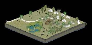
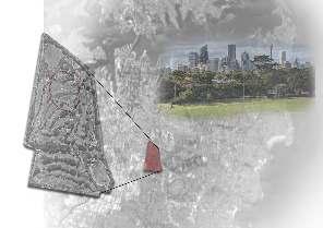
The project is located in Moore Park, which is part of Centennial Parklands, Sydney. The challenge here is to convert the Moore Park Golf Course (MPGC) into a park that is suitable for both golfers and public, and considering environmental, social, economic benefits. Conceiving a complex program for it based on research and site investigation.
Project Vision
The idea is based on urban environments and mental health. Including health-promoting features of built environment is needed for a better future.
Provide citizens with an "air journey" to improve mental happiness in the context of urbanisation by enhancing the experience and sense of air.
Project Principles
· SEEING AIR: Movement and the visual impact of air.
· TOCHING AIR: Playing with the wind and touch the wind blow on you.
· ABSORBING AIR : Getting the fresh air with a higher concentration of oxygen through native oxygenating plants.
· RECHARGING AIR: Provide people with a space for passive recreation and outdoor natural aerobic exercise
· AIR + MUSIC & DANCE: Outdoor open green space for playing and listening to music and dancing for improving mental health
20
Moore
LAND2313 Studio 7: Design With a Complex Program Term 3, Year 3, 2022
Location
Park, Sydney, Australia
Skills Developed:
21
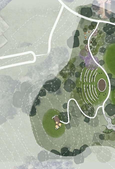


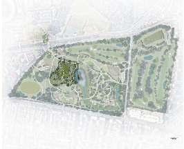
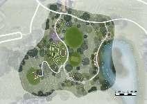
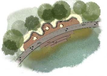
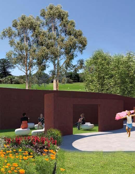
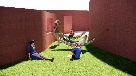
22 THE AIR 7 4 5 LEGEND 1.Playing with the air (Entry) 2.'Seeing Air' 3.'Funneling' 4.'Absorbing Air' (The Mound Steel) 5.Amphiteater 6.'Recharging Air' (for Yoga and other passive programs) 7.Event lawn 1 MASTERPLAN
Provide citizens with an "air journey" to improve mental happiness in the context of urbanisation by enhancing the experience and sense of air MUSIC RECHARGING AIR ABSORBING AIR SEEING AIR PROJECT PRINCIPLES 'air' with 'exercise' 'air' with 'performing arts' 'air' with 'senses' TOCHING AIR DANCE Movement and the visual impact of air. Playing with the wind and touch the wind blow on you. Getting the fresh air with a higher concentration of oxygen through native oxygenating plants. Provide people with a space for passive recreation and outdoor natural aerobic exercise Outdoor open green space for playing and listening to music and dancing for improving mental health PROJECT IDENTITY PROGRAMS 1.Moore Park Bat and Ball Oval 2.Event lawn 3.Amphitheater with platform 4.Observation tower and platform on the top of the mound 5.Car parking 6.Skate park 7.Urban oxygen cafe and restaurants (Dining area) 8.Ecological bridge 9.Amphitheater besides water 10.Dog park 11.Natural play-garden 12.Waterside track 13.Species gallery 14.Forest walk and view stop: walking path and resting 15.Family Mini Golf area 16.South land bridge 17.Golf Course (9 holes) 18.Driving range 19.Golf club houses 20.Tennis Courts 21.Water system for WSUD 22.Bridges SCALE BAR (adaptated or upgraded from the group work masterplan) GROUP MASTERPLAN Group Work Masterplan Title: Oxygen Hub CONTEXT PLAN CONTEXT
Sydney CBD "THE AIR" (Individual Work) Site Chosen Boundary "OXYGEN HUB" (Group Work) Site Chosen Boundary defined by all group 7 members THE AIR We proposed to reduce the 18-holes golf course to a 9-holes golf course, leaving the rest space being a public park. Golf Course (9-holes)
PROJECT VISION
Moore Park
ISSUES
URBAN ENVIRONMENTS & MENTAL HEALTH

URBANISATION
With the rise of urbanization, mental disorders such as DEPRESSION are also increasing rapidly

MENTAL HEALTH
https://www.phrp.com.au/wp-content/uploads/2014/10/NB07024.pdf https://news.stanford.edu/2015/06/30/hiking-mental-health-063015/ https://chphealthmt.org/news/what-fresh-air-does-for-your-health

FRESH
https://www.phrp.com.au/wp-content/uploads/2014/10/NB07024.pdf
RELAXING

23 N 1 2 3 7 6
Public Health Research & Practice published an article called 'Crowded suburbs' and 'killer cities': a brief review of the relationship between urban environments and mental health, it said that "90% of Australian living in unban settlements of more than for thousand people" "One in five Auseralion neeting the diagnostic criteria for a mentaL health problems (like depression and antiery) each year" - Public Health Research & Practice
Improve Your Mental Health and Increase Happiness. Mental health prescription: Nature
Increased unbanisation occured in Sydney and Australia has a less expected dounside, it mates Australians more vulnerable to cause various mental illnesses
AIR
Breathe the fresh air and exposure to nature can help “buffer” against depression and reduce mental stress
NATURE
MENTAL HEALTH
natural areas may be vital for mental health in our rapidly urbanizing world”
in
was found to have a positive effect on mood and
of
function, including working memory, as well as a dampening effect on anxiety."
Landscape and Urban Planning
Bratman,
researchers CONTEXT ZONING MAP 1 2 3 4 5 1 LEGEND Space 1.Playing With the Wind Space 2.'Seeing Air' Space 3.'Funneling' Space 4.'Absorbing Air' Space 5.'Recharging Air' N
https://news.stanford.edu/2015/06/30/hiking-mental-health-063015/ https://chphealthmt.org/news/what-fresh-air-does-for-your-health SDG "Accessible
"time
nature
aspects
cognitive
-
by
Stanford
DETAILED DESIGN


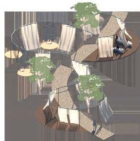


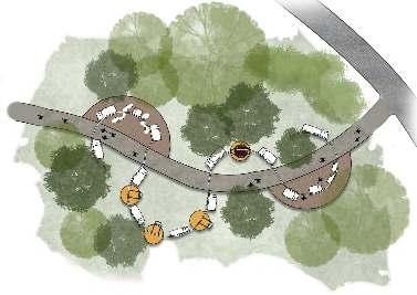
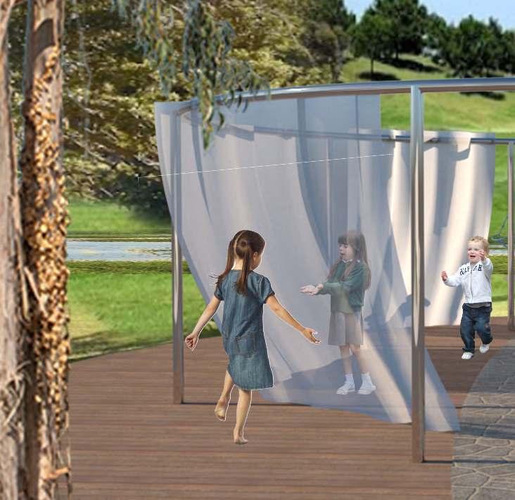
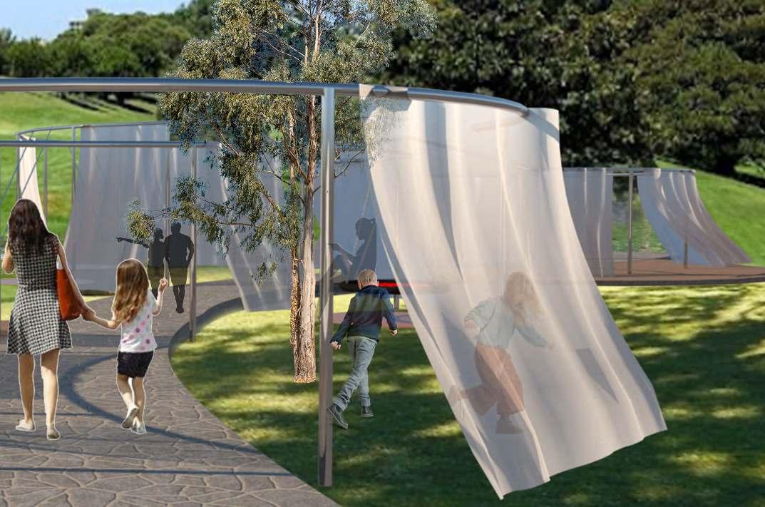
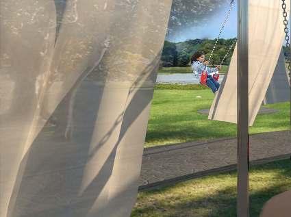
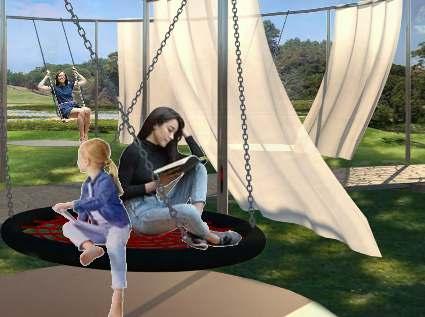
THE AIR JOURNEY | SPACE 1 PLAYING WITH THE WIND (ENTRY)
Relevant principles:
'Playing with the wind' is the first artwork, designed to enhance the visitor's experience of the sense of feeling air. In this space, there are a series of sitting and playing spaces for groups or individual people to sit and play while breathing the fresh air and relax.
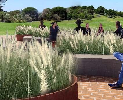
This dynamic corridor, the white cloth half blocks the view, gives people a sense of mystery to attract people to explore inside.
A place to walk, run or cycle through. The air blows on these white polyester clothes and make it flutter, giving visitors a visual impact of air movement and windblowing experience and a sense of relaxation and pleasure.

24
SEEING AIR TOCHING AIR
ENTRY
Swing Swing
White stainless steel round tube
Native Trees
Stone Path
Polyester PES Fabric
1
'SEEING AIR'

AIR
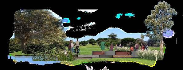
JOURNEY | SPACE 2 ABSORBING AIR

Relevant principles:
SEEING AIR
Submerged, floating and emergent oxygenating wetland Plants Pennisetum alopecuroides (Swamp Foxtail Grass) Broadleaf Cumbungi (Typha orientalis) Soft-stem Bulrush Duckweed


25
THE Plant some native plants on both sides of the path, and all the grasses on the ground ane influenced by the wind when people sit beside or walk through.
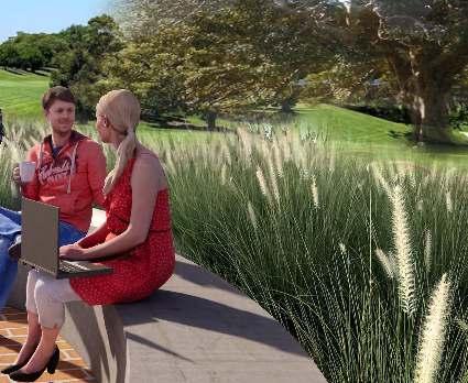
In this space, creating a series of sitting spaces for groups or individual people to sit and relax, and enjoy the fresh air while reading, and communicating. It is also a place to walk, run or cycle through.
'FUNNELING'


THE AIR JOURNEY | SPACE 3
Relevant principles:
'FUNNELING' is the third stop of the 'air journey'. A very artistic space that can be experienced through walking. People also can choose to stop and sit in that four different sitting spaces to enjoy the fresh air and the wind. The cafe beside that opens one door to the wall side.
Bamboo is a crucial element in the balance of oxygen and carbon dioxide in the atmosphere. Bamboo produces more than 35% more oxygen than trees.
https://www.aussiebamboo.com.au/bamboo-plants-of-australia/ https://www.theguardian.com/environment/2003/mar/20/research.science


26
AIR TOUCHING AIR
SEEING
CAFE
ABSORBING AIR
Jacaranda mimosifolia (Jacaranda)
Westringia fruticosa (Native Rosemary)
Eucalyptus (Gum
Ficus macrophylla (Moreton Bay Fig)
Winter winds
Prevailing winds


Summer winds
https://mesonet.agron.iastate.edu/sites/windrose. phtml?network=AU__ASOS&station=YSSY


Site Wind Rose
The reason why I choose to shape my wall like this is that I did some research about wind direction in Sydney. so looking at the wind rose map, we can see the circulation of the prevailing winds between south and north by east direction. 'Funneling' will interact with the summer and prevailing winds and blocks the winter wind blowing from the west.
Airflow Directions
27
Cut Leaf Daisy Flannel Flowers Calendula
Native Australian bamboo:
Gracilis Slender Weaver
Funnelling wind into the wind channel so the wind blows through the walls to provide natural ventilation. Enjoy the nature sounds, listening to the rustling sound of Bamboo swaying in wind.
Eucalyptus (Gum Tree)
Araucaria heterophylla (Norfolk Island Pine)
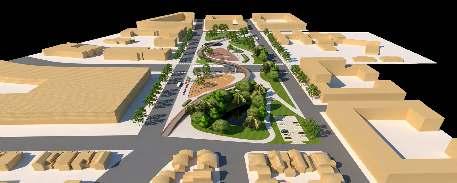
URBAN AND REGIONAL DESIGN
PRECINCT STRUCTURE PLAN OF ERMINGTON
INTERDISCIPLINARY WORKS
BEIL 6002
Urban and Regional Design
Term 3, Year 2, 2021
Location: Ermington, AU
In the interdisciplinary group work, as a landscape architect, I contributed to the idea of the Precinct Structure Plan of Ermington, and the details of the open space areas.
Project Principles
1.A Return to Squares and Courtyards: Good Enclosures
2.Open Spaces: Parks, Plazas and Public Realms
-Modern day interpretation of a relaxed and culturally enriched public realm
-Leon Krier’s sketches revealing his approach on sustainable urbanism within the scope of a city
3.Contemporary street life setting that offers neighborhood character & puts the people first.
BEIL0001
Graphic Design for the Built Environment
Term 3, Year 2, 2021
Location: UNSW Campus
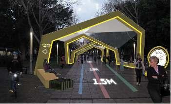
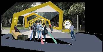
In the interdisciplinary group work, as a landscape architect, contributed to the external way-finding strategies (including access to light rail, university mall, Red Center West Wing Foyer), and collaborated with Architect/Industrial Designer.
Project Proposal
Combatting Covid
- COVID Signage Awareness Internally and Externally on campus
- Intentionally chosen 3 spaces within the UNSW Mall which experience the most human traffic where COVID messaged will target mass audiences
Environmental Awareness
- Sustainable materials (list materials - recycled steel, aluminium, timber, recycled vinyl)
- Inclusivity encouraged through multi-media signage including lighting for night time usage, enhancing safety
Increasing Brand Identity
- Motif of DNA graphic repeated throughout the proposal, aiming to enhance the campus experience whilst establishing clear COVID physical distancing measures which are easy to digest
- Design of furniture and sheltered walkways mirror the aim of increasing brand identity whilst also creating clear paths of travel, aligning with the university’s identity both during the day and at night
(All diagrams I show were drawn by me)
Skills Developed:
The detailed design of the open space area in Ermington
28
04
28
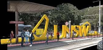
Anzac Parade Light Rail Terminus
The beginning of the covered shelter
The covered shelter begins at the Anazac Parade light rail terminus. It acts as a landmark which assists in wayfinding, di recting the audience through the arrow pointing within the beginning of the UNSW Mall and also through the signage of ‘UNSW’ allowing people to understand exactly where they are. COVID safety is reiterated through a suspended vinyl poster within the DNA graphic sign.
UNSW Law, UNSW Mall.
Covered Shelter Concept
The shelter continues from the Lightrail Terminus signage and evolves from a continuous line outlining the journey from the terminus to the RCWW. It acts as a physical form of direction/circulation which leads patrons through their journey within the UNSW mall which is also sheltered and allows for seating within such a vast span of space.
The shelter is made of powdercoated yellow steel and the roof is covered by glass and aluminum plates. The shelter aims to address the natural lighting with shards of UNSW dna within the shadows; of which the roof has derived from.
Coloured vinyl strips on the ground correlate with directional signage used both internally and externally to allow for ease of access.


The end of the covered shelter is located in the RCWW courtyard. The DNA structure is reiterated and the seating base comes to a halt with the repetition of the UNSW signage. The signage is placed intentionally almost as an ‘arrow’ pointing towards the RCWW and acts as a vertical point of interest where other forms of direcionality are horizontal It’s a DNA shape structure with a
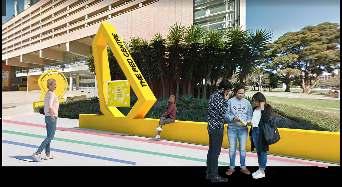
wall base.


29 P B B L B B L Bus Stop Parking Light Rail Disable Access UNSW Gate P P Gate 2 Gate 4 Gate 3 Gate 1 P Gate 14 Gate 13 P P Social Distancing Checking Point B P KE P OU STANCE Social distancing must be followed at all times, with people to keep 1.5m apart, especially in places with high traffic. STA C E P R TAN E E OU D AN E ! Emergency Help Point Remember to remain cautious at all times, especially at night time. ! ! !
Circulation
by
The middle of the covered shelter by night UNSW Law, UNSW Mall. The LED light strip is arranged along the line in order to allow for a similar experience of the UNSW Mall at night as that of the day, as well as allowing it to still be user friendly. By utilising lighting, COVID safety is addressed and reminds those who are using the space to phyically distance and stay safe. UNSW
The
the covered shelter
The middle of the covered shelter
day
RCWW Courtyard.
end of
seating
UNSW DNA Shape COVID Signage Poster Wayfinding Direction Identification Street Furniture Find Your Way To Red Centre West Wing and Please Keep 1.5m Social Distance GRAPHIC DESIGN FOR THE BUILT ENVIRONMENT BUILDING IDENTIFICATION AND DIRECTIONAL SIGNAGE
OTHER SKILLS 05
LAND2101
Landscape Studio 1: Design Fundamentals
Term 2, Year 1, 2020
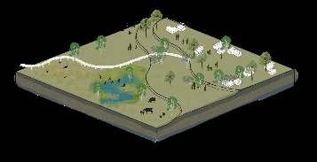
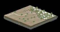
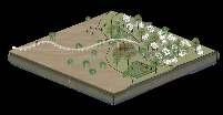
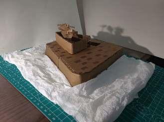
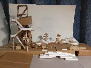
Project Name: ‘A Landscape Imagined – The Little Prince' Project Brief: the challenge here is to make an imagined landscape about ‘The Little Prince’ by Antoine De Saint-Exupery and use model making to explore landscape form and spatial qualities.
Narrative about the design:
When the little prince leaved the asteroid, he landed in a gentle valley. He will find a relatively high hill on the left side, and a relatively low hill on the right side. On the back is a grove of twelve baobab trees. The little prince is in a space with three sides closed and the another side open. Such an environment can serve as a refuge and a base. His asteroid is right in the center of this space.
LAND2102
Landscape Design Studio 2: Design Process
Term 3, Year 2, 2021

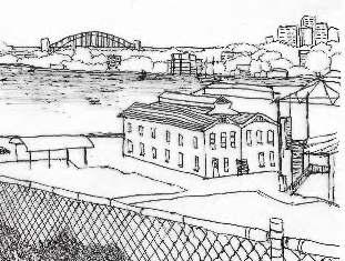
Project Location: Cockatoo Island
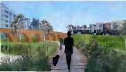
Project 3: Path, Prospect and Place Design statement
I take “view” as the theme throughout the whole design. Along the path journey, there are two historical heritages and a beautiful waterscape to be viewed. Around the site have many meaningful historical heritages and waterscapes. Such as the crane, the powerhouse chimney left over from the industrial era, an old boat and the convict settlement on the top of the cliff left over from the convict era. The water rises and falls along the slipway, which is a good place for people to get in touch with the water. These heritages and waterscapes are in different directions and at different heights. In order to let people have a more interesting experience to view those heritages, and point the viewing of these three directions, designed crane lookout platforms, a group of mounds and a sunken waterfront platform. These three parts enclosed a holistic space, providing different viewing points for people and a good place to rest and think.
LAND2152 Plants and Design
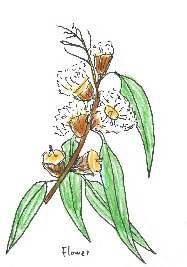
Term 3, Year 1, 2021
Project Location: Royal Botanic Garden Sydney
Project Brief: to prepare a personal herbarium of plants that will form the basis of their planting design works
LAND2201
Studio
3 Landform & Planting Design
Term 1, Year 2, 2021
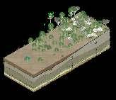
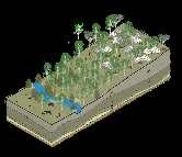
Project Location: Royal Botanic Garden Sydney
Project Name: protect water resources: precious blue water in the green water
Project Vision: the landsculpture is going to increase public awareness of the issue of climate change and aim to inspire visitors to take action by engaging with forms of flooding water.
Skills Developed:
HAND DRAWING & MODEL MAKING
HAND DRAWING
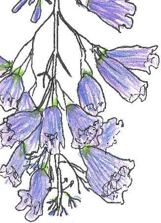
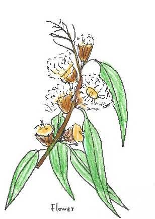
Herbarium, at Royal Botanic Garden Sydney (LAND2152 Plants and Design)
30
Drawing perspective showing waterfront platform design, Cockatoo Island (LAND2102) Drawing illustrating the character, vibe and atmosphere of the Cockatoo Island
30
Model Making
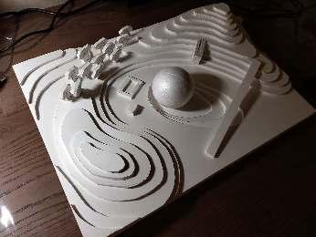
Protect water resources: precious blue water in the green water (LAND2201)

Cockatoo Island (LAND2102)
An imagined landscape about ‘The Little Prince’ by Antoine De SaintExupery (LAND2101)

Cockatoo Island (LAND2102)
31
Island (LAND2102)
32
