
14 minute read
Tappahannock, Virginia


Tappahannock VIRGINIA Tappahannock VIRGINIA By Karin Andrews Her early “historie” and present day offerings

Advertisement
The name “Rappahannock” literally means “rise and fall of water.” Thus, the name “Tappahannock” means “on the rise and fall of the waters” or in a more relevant present-day paraphrase, “town at the edge of where the water ebbs and flows.”
The river was then as now the center of commerce, culture, transportation and communication between the various tribes, in addition to being an abundant source of food. We can only imagine the pristine beauty, clear waters and wild beauty that Captain Smith found on his voyage up the Rappahannock. Indeed, the Rappahannock River is as important to us in many ways as it was to our ancient predecessors and forebearers.
Captain Smith also encountered (on his first visit) a less than friendly reception when he and his small band of explorers and their Native American guide “Mosco” were ambushed by a group of Rappahannock Indians hiding incognito in the bushes and marshes near Tappahannock. As news traveled quickly by river, the Rappahannocks were greatly irritated and offended that Captain Smith had accepted the hospitality of a rival tribe on the other side of the river. After the initial ambush, Smith and his band regained their bearings and fought back as recorded in this excerpt from his log:

“The next morning we went up the river and our friend Mosco followed us along the shore and at last desired to go with us in our boat. But as we passed by Pisacack, Matchopeak and Mecuppom—three towns situated upon high white, clay cliffs, the other side all a low-plain marsh, and the river there but narrow—thirty or forty of the Rappahannocks had so accommodated themselves with branches as we took them for little bushes growing among the sedge, still seeing their arrows strike the targets and dropped in the river; whereas Mosco [Smith’s Indian guide] fell flat in the boat on his face, crying “THE RAPPAHANNOCKS!” which presently we espied to be in the bushes; which at our first volley fell down into the sedge. When we were near half a mile from them, they showed themselves, dancing and singing very merrily.”
THE FIRST LAND IS PATENTED AND A TIMELINE BEGINS
In 1645, Bartholomew Hoskins patented the land that included what would become present day Tappahannock. In the 1650s, Virginia’s population nearly doubled as colonists, settlers, planters, tradesmen, servants and the like settled along the shores and lands that bordered the Rappahannock. The area we know as Tappahannock was settled and conquered by people from diverse backgrounds and countries of origin who equally share in what has made this area what it is today.
With the Colonial economy eventually shattered due to reliance solely on one
Perdue granaries. Photo courtesy of Dawn Howeth
DeShield’s Ferry, circa 1927
crop (tobacco) and other contributing factors, the Virginia House of Burgesses passed a law in 1680 requiring that each county in Virginia establish a town. This action was taken in part to diversify the economy and to help settle the “frontier.”
On March 25, 1682, a suitable site was purchased (in present day Essex) from Thomas and Benjamin Goodrich for 10,000 pounds of tobacco. The land was divided into half acre squares and established as a port and customs town for river traffic and trade activities, although a trading post run by Jacob Hobbs and a village known as “Hobbes his hole” or “Hobbs Hold” had already

been established. It is believed that the name “Hobbs his hole” or “Hobbs Hold” referred to the trading post being run by Jacob Hobbs with the land being held by patent or land grant.
In 1706, the town lots and streets were mapped out by Harry Beverley and included the same names in use to this very day, such as: Prince, Cross, Queen, and Marsh Streets. Other present-day names include Church and Water Lanes. The colonial town of Tappahannock was a thriving port with all of the industry and services necessary to support it, such as taverns, shops, lodging, warehouses, blacksmiths, porters and more.
THE NAME “TAPPAHANNOCK” MEANS, “TOWN AT THE EDGE OF WHERE THE WATER EBBS AND FLOWS.”


TAPPAHANNOCK AND THE STAMP ACT
We often and most notably think of the Boston Tea Party as the first demonstrative protest to “taxation without representation,” however, protests against British tyranny and the Stamp Act took place here (in Tappahannock) seven years before the famed Boston Tea Party! The Leedstown Resolutions were signed shortly thereafter calling for all Virginians to disobey the British Crown and Parliament. Support for American independence had taken hold in Colonial Tappahannock with these first murmurings of independence.
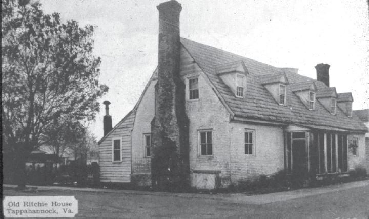
One of the wealthiest merchants of the day, who initially supported the Stamp Act but later rescinded his support in the interest of self-preservation, was Archibald Ritchie. His well-appointed complex was comprised of three main buildings—all connected by covered walkways—gardens, stables, kitchens, dependencies and a tavern store. One of the wealthiest merchants of his day, he controlled much of the trade in and out of Tappahannock. A portion of his complex
remains on Prince Street, as a prominent reminder of our Colonial past.
The original paneling from the Ritchie House now resides in the Tappahannock Room at the Winterthur Museum of American Decorative Arts in Delaware. Jesse Ball DuPont, a Northern Neck native and part-time resident of Tappahannock, purchased the interior paneling decades ago so that it would be preserved for future generations. The Ritchie House is now a law office. The conference room addition, finished in 2006, contains a 43-foot-long panoramic mural depicting Prince Street, the Ritchie House and the Port of Tappahannock as it might have appeared in the 1760s. With the independence of the American Colonies won at Yorktown in October of 1781, the British made one last assault on Tappahannock in 1814 by shelling and invading the town and burning numerous structures, homes and buildings.
THE EPITOME OF VIRGINIA TIDEWATER HOSPITALITY AND CULTURE IS REBORN
For decades after the Revolutionary War, Tappahannock languished with a population of about two hundred persons, until prosperity and growth took a foothold once again in the late 1830s. Steamboat service, which began in 1828, combined with the opening of the first bank in Tappahannock, once again returned the port town to her rightful place as one of the loveliest and most influential little towns on the Rappahannock.
The businesses in town existed to serve surrounding farms which had learned to replenish the soil and diversify their crops. Tappahannock once again became a business center.
Although there are numerous “missing icons” of Tappahannock’s grand and genteel past, such as Mrs. Lucy Gray’s School, aka Monument Place, the old Riverside Hotel and the Old Daingerfield House, efforts are underway in Tappahannock to preserve and revitalize our historic downtown. Homes such as the Anderton House, Brockenbrough House, Roane-Wright-Trible House and more still remain intact and are as lovely today as they were when they were first built. Several of these grand Colonial era buildings along Water Lane are now part of St. Margaret’s School.
Old Ritchie House

Southside Bank drive-through, circa 1950
St. Margaret’s School
Essex High School

IN 1927 THE FIRST DOWNING BRIDGE WAS
The Roane-Wright-Trible house is now the highly acclaimed Essex Inn and, of course, the Old Customs House remains; as does Emerson’s Ordinary, the Debtors’ Prison and Old Clerk’s Office. A second Courthouse, built in 1848, stands in all of her roman revival glory, as a witness to the prominence and affluence of Essex in the nineteenth century. The classic Gothic revival architecture of St. John’s Church and the Old Beale Memorial Church bears witness as well to the faith of our town fathers and mothers.
If time travel were possible, visitors from the past would surely know they were in Tappahannock by the many dwellings still remaining. Every age in Tappahannock has made its mark on our architectural heritage, for better or for worse.
TRANSPORTATION ADVANCES THE LOCAL ECONOMY
In the seventeenth and eighteenth centuries, the primary mode of transportation was by sail and horsepower. In the nineteenth and early twentieth centuries, sail power was supplemented and, in some cases, replaced by steamboat travel and shipping technologies, which revolutionized the ability of farmers and watermen to ship their products to faraway places without fear of spoilage. Tappahannock was strategically located with a fantastic natural harbor that elevated her once again to her rightful place of prominence in the Rappahannock River Valley. Now linked with the entire Chesapeake Bay Region and beyond, the area’s families, businesses and farmers had the ability to have broader buying and selling choices. It was a faster and more fashionable mode of travel for excursions to Norfolk and Baltimore. It became an event to purchase all sorts of necessary things, like furniture, fabrics and more.
The steamboats discontinued their service in the late 1930s as the railroad and roadways linked Tappahannock and surrounding areas with Richmond, Fredericksburg and Williamsburg. The very last remaining pilings of Tappahannock’s old steamboat wharf can still be seen, if one knows where to look and oh, the stories that have been told over the years about those steamboat
excursions and the old landing itself!
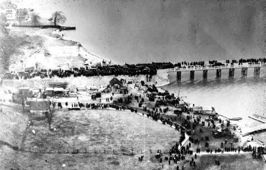
In 1927 the first Downing Bridge was opened which permanently linked Tappahannock and the Northern Neck —making the ferry boats which carried passengers and their automobiles from one side of the river to the other obsolete. In 1963, the present-day bridge was opened, replacing the earlier bridge of 1927. I cannot think of anything today that might possibly compare with these monumental transportation developments in Tappahannock’s past.

TAPPAHANNOCK’S COMMERCIAL DISTRICT MOVES
Some things never change and Tappahannock’s prominence as a crossroads and thoroughfare for travelers and merchants is still one that ensures that the local economy will continue. As land in Tappahannock becomes more and more scarce, it becomes necessary to make wise choices regarding how the town will utilize its remaining lands and growth in the future.
For decades the downtown portion of Tappahannock was a thriving community in its own right where the people of Tappahannock, Essex and those passing through would transact all sorts of business, from grocery shopping and banking, to the buying of fine clothing, household items, bridal couture and hardware. Downtown Tappahannock on Prince Street had it all! Culturally the town was close- knit with big community days held each year.
Mayor Roy Gladding fondly remembers when rescue squad members would stand at the only stoplight in town with minnow nets and ask passing cars for donations. “We’d ask for passersby to put in their change and donations to go toward the rescue squad. That’s how we raised money back in those days and how much times have changed, in some ways. We also had boat races in Tappahannock in front of the Southside Hotel, at Richmond Beach and in front of Harry T’s. The Fire Department had its annual carnival and every year the local dealers would give away an automobile. It was a huge fundraiser and a big community day!”
For those of us who can remember the downtown district and how much was available there, we can also remember well when French’s Market relocated in the early 1970s to the shopping center. French’s was a fantastic grocery store—strong on customer service in the tradition of the old Ukrops. Ben Franklin was located close by, as was the Golden Skillet. French’s had been the biggest draw to the downtown area, as was the Daw

Tappahannock Farmers’ Market. Photo courtesy of Dawn Howeth
EFFORTS ARE UNDER
Lowe’s opening (top), Essex County Women’s Club (left), Richie House (right). Photos by David Broad


Theater, Anderton’s Department Store and Lankford’s. Another shopping center was built which housed Roses, Safeway, Hicklin-Coleman Clothing and other retail outlets, which have long since gone by the wayside. The commercial hub of Tappahannock eventually moved to where it is remains today—along U.S. 17.
TAPPAHANNOCK TODAY
Tappahannock’s Mayor believes that “the townspeople know best what to do with their own money” and is a big proponent of small and limited government. He goes on to say that “a big part of my job as mayor, is to explain why our local government does the things that it does, on issues like the meal tax that was approved by the town council or the relocation of the airport.
“Tax dollars generated by the meal tax have gone toward offsetting the cost of Tappahannock’s wastewater treatment facility that would have been passed on to the citizens of Tappahannock otherwise. As it is, the motels, hotels, restaurants and eateries are large users of our water treatment and water supply system. For the most part, they cater to people and entities that do not live here. The meals tax was the best and fairest way of passing on the cost of providing clean water in a way that would not saddle the town citizens with an unfair tax burden.
“Tappahannock is just about built out. As there is very little room for future R-3 and R-4 development, the old airport site provides fifty-two acres of land that can be utilized for future light industrial applications. Down the road we see the county allowing development west of town on 360 going towards Richmond and around Bray’s Fork. We are anticipating these future needs by applying to the Commonwealth now, for a future well permit. The old airport location on Airport Road has freed up valuable land that the town of Tappahannock can develop—adding jobs for the future.”
IN CLOSING
Tappahannock offers education through both public and private schools, ample available housing and an infrastructure that is looking toward the future in a way

that protects the quality of water and life around Tappahannock. Opportunities for recreation, antiquing, local cuisine, walking tours and relaxation characterize Tappahannock and Essex County as a “go to” destination.
Although growing and responding to the needs of its citizens in a proactive way, Tappahannock has retained enough of its rural charm to remain appealing to come here’s, come back here’s, natives and visitors alike. Ideally situated on U.S. Route 17 between Fredericksburg and Newport News and one hour from Richmond, Tappahannock continues to be a crossroads and main thoroughfare. The community spirit that once characterized this lovely tidewater town is being revived with each passing year.
The Essex County Museum has done a wonderful job in preserving the past historical record and tangible items from our past. Although a complete record may never be possible, they are off to a great start. Who knows what great things yet await the museum?
The Main Street Committee has identified specific project plans for the future that can help transform Tappahannock’s once thriving downtown —one section at a time. A cultural arts center is also something that may one day find a home in Tappahannock.
In closing, there is perhaps no other street in all of Tidewater Virginia (to me) as lovely as Water Lane—any time of year. The backdrop of the Rappahannock River combined with the centuries old
Aerial view of the town center

Blue Crabs. Photo courtesy of David Broad

architecture still found here has caused this part of town to retain its “centuries old” appeal. All of these things combined remind us so often why we still love this sleepy little town at the edge of where the water ebbs and flows.


