
PORTFOLIO
Urban/Transportation Planning & Design |
Jerry Hsu
This page intentionally left blank
Los Angeles, California
May 25, 2024

PORTFOLIO | Urban/Transportation Planning & Design
Jerry Hsu
Photo taken by Jerry Hsu
7th Street/Metro Center station
TABLE OF CONTENTS

Sunset Boulevard: Street Improvement Project | Los Angeles, California

3rd Street Open Space Design | Pomona, California
Hollywood Blvd Promenade: Street Closure Proposal | Los Angeles, California

Pasadena, California


ArcGIS Pro AutoCAD SketchUp Synchro Studio

EDUCATION

JERRY HSU Urban/Transportation Planner

626-698-5117

jshsu1117@gmail.com

linkedin.com/in/jshsu1117

Adobe Creative Suite • Illustrator
• Photoshop
• InDesign


Microsoft Office Suite • Word • PowerPoint • Excel Language • English • Mandarin Chinese
• Taiwanese

RELEVANT COURSEWORK
Master of Urban & Regional Planning [Graduated May, 2024]
California State Polytechnic University, Pomona
Specialized in Transportation Planning & Urban Design
B.S. in Urban & Regional Planning
California State Polytechnic University, Pomona
Subplan - Transportation Planning

SKILLS REFERENCES
Dr. Frank Wen
wen@scag.ca.gov
Manager, Planning Strategy Dept.
Southern California Association of Governments (SCAG)
Rich Dilluvio
rdilluvio@cityofpasadena.net
Principal Transportation Planner
Pasadena Department of Transportation
• Transportation Modeling & Travel Demand Forecasting Methods
• Local Transportation Supply & Demand Management
• Regional Transportation Policy & Planning
• Visual Communication for Design
• Physical Design Applications
• GIS for Planning
Isabel Cárdenas
isabel.cardenas@lacity.org
Transportation Planning
Associate II LADOT
Paul Herrmann
P.Herrmann@fehrandpeers.com
Senior Associate Fehr & Peers


WORK EXPERIENCE
Planning Intern [Oct, 2023] – [June, 2024]
LADOT - Los Angeles, California
Participate in mobility projects for Los Angeles through data analysis, evaluating effectiveness post-implementation, and creating visualizations and infographics. Completed achievements and tasks include:
• Led data collection and analysis for the Annual Walk & Bike Program from 100 locations, creating visualizations for Story Maps.
• Utilized ArcGIS tools and principles like zoning and the High Injury Network (HIN) to qualify multiple Business Activity Districts.
• Completed project evaluations using given data, demonstrating the effectiveness of bus lanes, bike lanes, ZICLA, and hardened centerlines. Provided supervisors and the department with potential planning recommendations.
• Assisted with the L.A. Al Fresco program, completed the application reviews for the outdoor dining program, and screened out over a hundred no longer qualified restaurants.
Planning Intern [Nov, 2022] – [April, 2023]
Active SGV - El Monte, California
Primarily responsible for promoting a more sustainable neighborhood through mobility and greening projects. Duties included:
• Assisted the client in planning outreach strategies and creating flyers, successfully collecting targeted surveys as required.
• Coordinated stakeholders and residents, successfully facilitated public outreach by hosting workshops and community pop-ups.
• Organized a 6.5-mile-long open streets event to promote active travel, attracting over ten thousand participants walking and biking.
Transportation Planner [Mar, 2021] – [July, 2022]
Smartway Solutions Inc. - Taipei, Taiwan
Specialized in projects such as transit planning, traffic improvement plans, streetscape design, parking management, Mobility as a Service (MaaS), and projects for DOTs and Metro. Accomplishments include:
• Participated in Taipei's bustling Eastern District Corridor Master Plan, completing the drafting of a professional report that included conducting comprehensive traffic analysis and designing streets and roundabouts.
• Assisted the science park in identifying congested road segments and accident hotspots, conducted case studies on science parks worldwide, such as Silicon Valley, to provide potential traffic reduction strategies, and offered solutions for parking management.
• Developed an outreach plan for the city's MaaS project, led the workshops, and collected 500+ surveys at various train stations.
• Coordinated and collaborated with 20+ bus companies and the Metro to design and launch the integrated monthly pass system.
• Designed a toolkit for the client to calculate GHG emissions from commuters using different transportation modes.
Re-visioning Washington Blvd for the City of Pasadena
BACKGROUND & CONTEXT
Project Overview
Type:
Location:
Client:
Project Scope: Skills:
Digital Software: Capstone Client Project Pasadena, California
Pasadena Department of Transportation
Transportation Planning & Design
Traffic Analysis, Geographic Information System, Visual Communication Techniques
• Adobe Creative Suite
• AutoCAD
• SketchUp
• ArcGIS Pro
• Synchro Studio
Project Summary
Re-visioning Washington Boulevard is a street improvement project in Pasadena, California, aimed at enhancing streetscapes and different modes of transportation. Led by the City of Pasadena’s Department of Transportation, the project seeks to improve bike accessibility, walkability, and promote multimodal transportation along the corridor. Drawing on the Pasadena Bike Action Plan, Street Design Guide and NACTO Street Design Guide, the project will propose a new street design through visual communication techniques. This effort supports Pasadena’s commitment to sustainable urban development and biking infrastructure advancement.
Objectives
• Promote active transportation-friendly streets.
• Utilize data collection and analysis capabilities to inform decision-making.
• Demonstrate the implementation of the Complete Streets concept in a real-world streetscape project.
• Incorporate sustainable design principles from the Pasadena and NACTO Street Design Guide.
• Offer recommendations for street redesign to the client based on investigation and analysis.
• Showcase the ability to independently handle the complete transportation planning report.

CORRIDOR STUDIES
Commuting Characteristics

Traffic Accident Analysis

Traffic Volume

Existing Road Configuration

DESIGN CONCEPTS
Class II: On-Street Bike Lane

CORRIDOR PLAN
Concept A

Class IV: Separated Bikeways

Concept B

PHOTOSIMULATION
Bike Lane Buffer

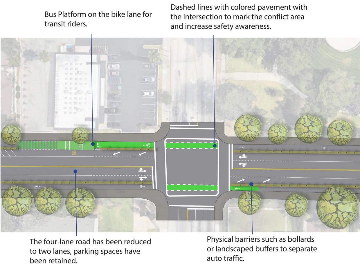
Bus Platform & Street Crossing

2-way Cycle Track


Bike Boxes
Sunset Boulevard Complete Streets Improvement Plan
BACKGROUND & CONTEXT
Project Overview
Type:
Location:
Project Scope:
Skills:
Contributors:
Graduate Studio
Los Angeles, California
Transportation Planning & Design
Traffic Analysis, Geographic Information System, Visual Communication Techniques
• Jerry Hsu (Project Manager, Transportation Planner & Designer)
• Shaun Kramm (Development Specialist)
• Danqing Sun (Urban &GIS Analyst)
• Ansis Hoheisel (Community Outreach Specialist)
Project Summary
The Sunset Boulevard Complete Streets Improvement Plan in Los Angeles aims to revitalize the corridor, accommodating various modes of transportation in this transit-rich area. Despite urban development near landmarks like Dodger Stadium and Union Station, Sunset Blvd remains predominantly autooriented, lacking accessibility for pedestrians, cyclists, and transit users. Through the principles of Complete Streets, the project will propose design enhancements to promote walkability, improve bike accessibility, and support multimodal transportation. In collaboration with local stakeholders, the project aims to create a vibrant and inclusive streetscape that reflects the diverse needs of the community.
Objectives
• Revitalize Sunset Blvd through the implementation of the Complete Streets concept.
• Reference the Los Angeles Complete Streets Design Guide for street design considerations.
• Utilize recommendations from the NACTO Street Design Guide for urban bikeway and street transformation.
• Conduct comprehensive traffic analysis and traffic accident studies using TIMS.
• Serve as the project manager, demonstrating leadership by overseeing major tasks, coordinating team members’ involvement, and reporting progress.

CORRIDOR ANALYSIS
Study Area

SUNSET 2.0 CONCEPTUAL DESIGN
Street Cross-Section
SWOT
Strengths
Cultural expression
Connectivity
Economic vitality
Streetscape conditions
Opportunities
Public transit-rich area
Dodger fans
Complete streets
Future developments
Weeknesses
Congestion
High dependence on cars
Lack of bike infrastructure
Dodger Stadium traffic
Threats
Gentrification
Traffic accidents & violence
Auto-oriented car culture
Opposition to road diet


PEDESTRIAN IMPROVEMENTS
Everett St - White Knoll Dr

Marked Street Crossing


Jerry Hsu
Refuge Island
Bike Lane Cross Section

Side Boarding Island Stop

Photosimulation

Sunset / Marion Bus Stop Rendering

3rd Street Open Space Design
Pomona, California
BACKGROUND & CONTEXT
Project Overview
Type:
Location:
Project Scope:
Skills: Contributors:
Urban Design Studio
Pomona, California
Urban Open Space & Streetscape Design, Neighborhood Revitalization Plan
Research, Spatial Analysis, Geographic Information System, LEED Rating System, Visual Communication Techniques
• Jerry Hsu (Project Manager)
• Kester Iden De Veyra (Designer)
• Priscilla Robles (GIS Specialist)
Project Summary
The 3rd Street Open Space Design project in Pomona, California is focused on revitalizing a low-usage surface parking lot into a dynamic urban space, serving as a central gathering point for the neighborhood. This effort involves proposing a new streetscape design and integrating various amenities into the open space, such as fountains and an amphitheater. The overall aim is to promote a healthier lifestyle, stimulate urban activities, and elevate the well-being of the community. Through this revitalization initiative, the project seeks to encourage community engagement and cultivate a vibrant urban atmosphere in Pomona, enriching the lives of its residents and visitors alike.
Objectives
• Create a unique open space dedicated to outdoor activities, enchancing community engagement and recreation.
• Conduct spatial analysis to optimize circulation and sunlight exposure within the space.
• Utilize LEED’s framework for sustainable and cost-saving green design.
• Redesign streetscape to prioritize pedestrian activities and safety.
• Demonstrate proficiency in urban design skills through innovative and practical implementation.
• Provide zoning changes based on the design outcomes.

OPEN SPACE & STREETSCAPE DESIGN
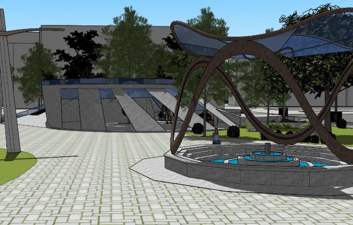
3D Conceptual Rendering

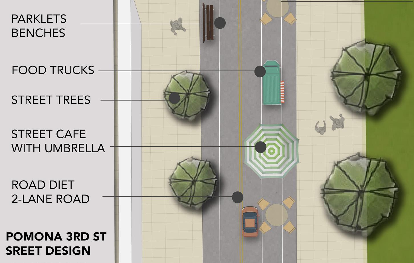
3rd Street Streetscape Design Plan

Fountain & Gazebo

Street View Rendering

Hollywood Blvd Promenade
Los Angeles, California
BACKGROUND & CONTEXT
Project Overview
Type:
Location:
Project Scope:
Skills:
Digital Software:
Communications Graphics For Planning
Los Angeles, California
Urban Open Space & Streetscape Design, Street Closure & Promenade Design
Research, Spatial Analysis, Visual Communication Techniques
• Adobe Illustrator
• Adobe Photoshop
• AutoCAD
• SketchUp
Project Summary
The primary inspiration for the Hollywood Boulevard Promenade project comes from the temporary street closures that occur during the Oscars. However, why not make this closure permanent? By doing so, Hollywood Boulevard, already a hub of walking activities, can be transformed into a more pedestrianfriendly area, attracting even more visitors. This project draws on the success of the Santa Monica Third Street Promenade as a case study. By designing a unique promenade for Hollywood Boulevard, this proposal would not only enhance the pedestrian experience but also boost local businesses and contribute to the cultural and economic vitality of the area.
Objectives
• Conduct case studies of successful pedestrian promenades to gather insights and best practices.
• Identify and analyze reference projects suitable for application to Hollywood Boulevard.
• Develop a comprehensive design plan that enhances pedestrian safety and enjoyment.
• Promote walkability by converting Hollywood Boulevard into a permanent promenade.
• Create strategies to attract more tourists and boost local businesses.

Hollywood Boulevard Master Plan
Site Plan

Perspective View


Hollywood & Highland
Hollywood & La Brea
Academic Research & Assignments
First/Last Mile Connection in LA
Course:
Abstract:
Undergraduate Thesis
Deep in Los Angeles, where infrastructure revolves around automobiles, public transit connectivity suffers. This paper delves into the challenges of first & last mile connectivity to rail stations in Los Angeles, proposing solutions. Divided into three categories: active travel, car sharing, and bus/shuttle systems, it discusses findings from interviews and surveys, along with case studies worldwide. With over 70% of respondents relying on personal vehicles, recommendations are made to promote alternative transportation methods in Los Angeles for first and last mile connections.

LAX - Union Station Express Train Study
Course: Summary:
URP 4880
Local Transportation
Explored the feasibility of connecting LAX to Union Station. Based on the case studies of major international airports and transportation hubs in the U.S. and worldwide, it offers route and land use recommendations for Los Angeles.

LAX APM Public Outreach Plan
Course:
URP 4240
Public Participation
Summary:
The public outreach plan engages the public to understand their needs and expectations for the Automated People Mover (APM), aligning these with the project’s goals.

LA Metro Gold Line Foothill Extension Phase 2B Policy Analysis
Course:
URP 5120
Planning Ideas and Actions
Summary:
The Foothill Extension Phase 2B Gold Line project aims to enhance transit options in the San Gabriel Valley and Inland Empire, extending 12.3 miles beyond Azusa with new stations. Budgeted at $2.1 billion, it’s a priority for completion by 2028. However, our group suggests that commuter rail would better serve the distance from Downtown LA to Montclair due to its efficiency and lower cost compared to light rail. With low current ridership and concerns about safety on light rail, commuter rail emerges as the favorable alternative.

GIS Analysis: Metro Gold Line Impact Elmwood Revitalization Project
Course: Summary:
URP 5250 GIS for Planning
This GIS project analyzes the impact of the Metro Gold Line Extension on Sierra Madre and other Transit-Oriented Districts in Los Angeles using GIS techniques, aiming to determine whether TODs help boost transit ridership.

Course: Summary:
URP 5830 Development Process
This project is designed to a Request for Proposal (RFP) and focuses on the Downtown revitalization in Elmwood, PA. The plan includes creating walkable spaces and implementing extensive spatial planning initiatives.

Other Professional Projects
Los Angeles, California
LADOT Annual Walk & Bike Count

ZICLA Project Evaluation Program

Hardened Centerlines Evaluation Program

LADOT BAD Qualification Program

Norwood Greening Project


Puente Hills Landfill Park
Taipei, Taiwan

Taipei Eastern District - Liveable Corridor Master Plan

MRT - CarbonFootprint
Transit Tracker

Hsinchu Science Park Traffic Improvement Project

Taichung MRT
TPass Program

Kaohsiung MaaS Implementation Project


Photo taken by Jerry Hsu
Jackson - CTA Red Line Subway Station Chicago, Illinois
This page intentionally left blank

PORTFOLIO | Urban/Transportation Planning & Design | Jerry Hsu
