
ArgosaronicislandsAspectsofalongstandingmaritimetradition


© 2022 ΚΕΑΝ - CELL OF ALTERNATIVE YOUTH ACTIVITIESISBN:978-618-82380-1-5 Contents Co-funded by the Greek State and the European Union in the contex of the Operational Programme “Maritime & Fisheries 2014-2020” Greetings 2 - 3 Attica’s insular landscape 4 Angistri 6 Aegina 7 Cythera-Anticythera 10 Poros 13 Salamis 17 Spetses 19 Troezenia-Methana 23 Hydra-Dokos 25 Bibliography 30 G K Media Publishing ΙΚΕ 206 Sygrou Avenue, Κallithea 176 72, Greece, +30 210 9580 876 PRODUCTION DESIGN CREATIVEGENERALMANAGEMENTEDITING Dr Anastasia Leriou WRITERS Dr AnastasiaDimitriosArchaeologistLeriouKitsos Historian, MA War Studies ENGLISH RENDERING Dr Georgios Lerios DESKTOP PUBLISHING Petros Karoutsos ChristosDimitrisMammelisPanagos P RINTING Printfair Ltd 3 Violetas Street Acharnai 136 71 OFFREEDISTRIBUTEDCHARGE ArgosaronicislandsAspectsofalongstandingmaritimetradition


2
The eight Municipalities of the Regional Unit of Attica Is lands (Salamis, Aegina, Angistri, Poros, Hydra, Spetses), the Methana peninsula and Troezenia and Cythera-An ticythera have inextricable links with sea and seafaring . The present edition is intended to give aspects of this long-standing relationship between these lands and the sea and is another step towards introducing and promot ing our region to visitors
I would like to thank all members of the network for their dedication and also the EMFF for financing KEAN for this publication
At the initiative of local communities, the European Com mission adopted, thirty years ago, a new approach to rural development, the LEADER method, which focuses on the participation of local population and public-private
Giannis Zorbas, President of the CLLD/ LEADER Programme Management Committee
Sixpartnershipyearsago, the Network for the Cooperation of Mu nicipalities of the Regional Unit of Attica Islands was cre ated to design and implement the Attica Islands CLLD programme entitled Culture & Environment «On Board» The local programme Maritme & Fisheries in particular responded to the needs of our insular region

3
This quote by Nikos Kazantzakis came to my mind when we took on the responsibility of creating and producing the publication you are holding in your hands
Stavros Milionis

You have your brush, you have your colours, you paint the paradise, then in you go
“ ”
The enhancement of maritime and fishing history and tra dition of the Saronic Gulf islands highlight their attractive ness as a tourist destination . The experienced scholars have worked with dedication and consistency so that the public can access information on the history of the area and discover new points of interest
President of the CELL OF ALTERNATIVE YOUTH ACTIVITIES (KEAN)
We live in a blessed place and we often forget to hon our and share its graces and joys This is the aim of this publication It contains a collection of texts tracing the his tory of the wonderful Saronic Gulf islands from antiquity to the present day, with emphasis on the entire historical spectrum of the islands’ maritime and fishing traditions .
Fishing has been the first human activity in rela tion to the sea, as it is directly related to food and, thus, survival As such, it has played a central role in the life of the inhabitants of the Argosaronic Sea, from ancient times to the present day Today, fish ing and aquaculture constitute key sectors in the ar ea’s economy, with a large number of fishing har bors and unloading ports, where catches are land ed or marketed for the first time, and almost half of the professional fishing fleet in the Attica Region
Besides fishing, the following pages present various aspects of the maritime tradition of the ar eas of the Cooperation Network of the Region al Unit of Attica Islands; these are associated to their history, ancient, medieval, or more recent, geography, economy and traditional professions (shipwrights, merchants), their architectural char acter as showcased by the ports and lighthous es, but also the local traditions and customs The aim of this project is to highlight the consistently dominant role of the sea in the history and cul ture of these places
The aim of this publication is to concisely present the maritime tradition of the islands and the re gions which, as Municipalities, constitute the Net work for the Cooperation of Municipalities of the Regional Unit of Attica Islands, namely the islands of the Argosaronic Gulf (Salamis, Aegina, Angis tri, Poros, Hydra, Spetses), the peninsula of Meth ana and Troizinia, and Cythera-Anticythera This group, which, prior to the implementation of the Kallikratis Programme (2011), belonged to the Pre fecture of Piraeus, is one of the eight units of the Attica Region Its total area does not exceed 879 square kilometres, while its permanent population, according to the 2011 census, amounts to 74,651 inhabitants Although, at first glance, what con nects the islands and regions of the Network pri marily relates to State administrative organization of the last decades, their insular/coastal character in conjunction with their geographical contiguity, is the main reason for the strong cultural ties that exist between them
The islands of the Argosaronic are small and, therefore, do not have sufficient arable land, an element which forced their inhabitants to turn to wards the sea early, thus giving a distinct insu lar character and remarkable extroversion to their material culture The short distances that separate them from each other, but also from the neigh bouring coasts, favoured the development of sea faring from a very early age, as evidenced by the great maritime tradition of some of them (e g Hydra, Spetses, Poros), during the modern era The surrounding sea connects them both to each other and to the neighbouring lands, where im portant cultural-administrative centres developed, under whose influence the Argosaronic regions were also partially included There is the Argolic Gulf, which washes the southern coastline of Ar golis, and the Saronic Gulf, which is defined by the western coast of Attica and the eastern coast of Corinthia and the Argolid . Spetses, Hydra and
Anticythera are located south of Laconia and Elafonisos and north of Crete, at the point where the Ionian, the Aegean and the Cre tan seas meet; after their incorporation into the Greek State, they joined the Prefecture of ArgolisCorinthia, where they remained until 1929, when they came under the Prefecture of Attica-Boeotia In 1996, after the formation of the Prefecture of Pi raeus and Islands (1968), they were annexed to it Since they are particularly distant geographi cally and included in the cultural spheres of Laco nia and Crete, they are not directly connected to the Argosaronic islands Nevertheless, they are in cluded in this edition as part of the Regional Unit of the Attica Islands
4
Dokos are located in the Argolic, while Salamis, Aegina, Angistri, Poros and the Methana peninsu la in the Saronic The Argosaronic emerges from these two Cytheragulfsand
Attica's insular landscape
5


6
Although the people of Angistri maintained contacts with Aegina and Salamis throughout the 18th and 19th centuries, as well as with the neigh bouring coast of the Peloponnese, a gasoline ship started running between Angistri and Aegina as late as 1932 Up to then, the only means of trans portation was boats In addition, the direct ferry connection of Angistri with Piraeus started in 1959, while earlier visitors reached Angistri through Ae gina, by boat Today, Angistri is connected to the port of Piraeus through regular daily Flying Dol phins and ferries Most of the island’s inhabitants work in the tourist industry, although there are also fishermen, sailors and merchants A professional fishing association operates on Angistri . [AL]
AngistriBetweenAeginaandthecoastof

Epidauria, the pine-clad Angistri is situated around 22 nautical miles south-east of the port of Piraeus The is land is mainly hilly and covered with pine for ests, while the arable land is limited and can be found mainly in the coastal zones, primari ly the north one The coastal morphology varies, as one can find smooth beaches but also inac cessible rugged coasts The sole natural harbour is located on the north-eastern part of the island, in Skala, while the artificial harbour of Megalo hori was inaugurated in 2006, with a view to fa
The earliest habitation of Angistri dates back to prehistoric times The obsidian blades that were imported from Melos and found in Agia Varvara and the rocky islet of Aponisos suggest that the local communities have been in contact with the Aegean Obviously, the inhabitants of the island would have capitalized on it throughout antiquity, in order to survive, but also to become actively in volved in the Saronic Gulf insular network Nev ertheless, there there have also been periods of complete desolation The me dieval fortifications in the west ern part of the Dorousa islet in dicate on the one hand that the area was inhabitated dur ing the Byzantine period and on the other the inhabitants’ need for protection from the dangers of open sea, especially pira cy As a result of the first administrative division of the independent Greek state in 1833, Aegi na and Angistri formed the Province of Aegina in the Prefecture of Attica and Boeotia The Angistri ans made a living from the exploitation of the res in produced by the numerous pines on the island, the cultivation of barley and figs, the production of wine and olive oil and fishing Later on, some of them got involved in the shipping industry
Map of Aegina and Angistri by Francesco Piacenza (1688)
cilitating the visitors Moreover, Angistri also fea tures a fishing harbour
Nowadays an island with a lot of tourist traffic, Ae gina has an extremely rich and centuries-old past, whereby the sea has played a decisive role The dynamic, everlasting engagement of the Aeginetans with water is attributed to the location of the island in the centre of the Saronic Gulf, at a distance of 10 5 and 12 nautical miles from Piraeus and the coast of Epidaurus respectively, while shorter distances sepa rate it from Salamis to the north, Poros to the south and Angistri to the east Apart from its strategic loca tion on a busy sailing network, particularly condu cive to the development of seafaring and other searelated activities, was the coastal morphology of Ae gina, which consists of extensive smooth shores, but also sloping coves, small or large This is particular ly the case in the island’s western section, which is dominated by the Marathonas bay, as well as the modern port and the largest settlement of the island This is where the ancient city of Aegina, as well as the extensive facilities of the ancient port were locat ed In contrast, the northern and eastern coasts are rockier and more ragged, with the exception of the large bay of Agia Marina Aegina has several ara ble lands inland, mainly in the large plain in its west ern part, where the famous pistachios are produced,
The first traces of human presence in Aegina date back to the Neolithic period, whereas during the Ear ly Bronze Age an important settlement had been es tablished in Kolona, at a site 12 metres above sea level, which offered safety and control of sea routes
but also grapes, olives, figs and almonds Until mod ern times and the establishment of pistachio cultiva tion, the island was self-sufficient Nevertheless, the Aeginetans were always looking towards the sea
In the area of Kolona and below modern Aegina one can find the ruins of the Iron Age city On the coast that extends to the south of Kolona Cape and is known as “Karantina”, the sunken remains of the jetties and the boathous es from the town’s naval base, also known as the “hidden harbour” can be found During the Archaic pe riod and until the beginning of the 5th century BC, Aegi
The inhabitants, actively involved in the maritime ex change network that had developed in the Aegean during the 3rd millennium, had contacts with the Ar golid, the Cyclades, Crete, but also the north-eastern Aegean and the Near East The settlement continued to prosper during the Late Bronze Age
Old anchor in the port of Aegina

7
Aegina
where boatyards can be found, even today On March 23, 1821, in alliance with the Poriots and the Salamians, they rebelled against the Sultan, having converted their merchant ships into war ships During the Revolution, Aegina, thanks to its strategic location, became a naval supply base, while it was a safe haven of many hundreds of refugees from other areas, such as Psara, after its sack in 1824 Liberation found the Aeginians set tled in the coastal area of the ancient centre of the island, which, after about a thousand years of desolation and abandonment, was to play a leading role as the capital of the new Greek state, during 1828-1829 On January 11/24, 1828 the English ship “Warspite”, carrying the governor Ioannis Kapodistrias and accompanied by two warships, one French and one Russian, entered the port of Aegina A new era of devel opment was starting for the island, which at that time had a population of 40,000 Nevertheless, after Athens became the new Greek capital, this number decreased drastically
Shortly after the arrival of Kapodistrias, the first lighthouse of the newly established Greek state was built, which was lit in 1829 or 1830 in the port of Aegina, in the small church of St Nickolas Thalassinos . This lighthouse has not survived as it was later destroyed for unknown reasons In 1881 the lighthouse was built in Plakakia, in the south ern part of the island, next to the small church of the Holy Apostles .
“Entrance to the old port of (WordsworthAegina”1871, 187)

8 na developed into a strong force in maritime trade with its products, mainly ceramics and metal objects, becoming popular all over the Aegean Coming into contact with other peoples, the Aegi netans were introduced to coin transactions and were the first in Greece to mint coins Apart from the archeological remains, the naval superiority of Aegina in antiquity is also attested in referenc es in ancient sources, the earliest being the one in the Iliad (B 562) In the “Catalogue of Ships”, it is mentioned specifically that Aegina participat ed in the Trojan campaign with 80 ships
In the first Byzantine centuries, Aegina continued to flourish, while in the 9th and 10th, the Arab invasions caused the population to diminish and retreat inland, where they built Paliachora in a naturally fortified site In the following centuries Aegina served as a base for pirates, whose crews had been joined by sever al of its inhabitants In 1204 it came under the rule of the Venetian Republic, where it remained until 1540, when it passed to the hands of the Sultan A little over a hundred years later, Francesco Morosini, in his cam paign against piracy in the Aegean, looted the island and almost destroyed Paliachora
At the beginning of the 19th century, habita tion began to move to the coastal zone and the Aeginetans turned, once again, to maritime ac tivities, gradually creating a fleet The shipbuild ing zone was located in the area of Kolona,
Navy mined in the sea zones of Tourlos-Fleves and Moni of Aegina-Agios Georgios of Metha na with the aim of creating a protected front In the following year, German aircrafts bombed Ae gina three times causing considerable damage to the port, while a few weeks later German troops landed at the forts of Tourlos and Perdika In Janu ary 1942 the German submarine U 133 was sunk by a mine off Tourlos
Although sponge fishing had almost been abandoned by the 1970s, in 1971 it was esti mated that fishermen made up 40% of the Aegi nean workforce Fishing activity remains high to this day: the island’s port is used for unloading fish and by 239 professional fishing boats In ad dition, there are two fishing harbors (Aegina port, Perdika), and two professional fishing associations However, the economy of modern Aegina is pri marily focused on tourism, which is particularly fa voured by the short distance that separates the is land from the Greek capital, with which it is connected by numerous sea routes [AL]
9
Shipyard in Aegina, 1940s

Under Metaxas, naval forts had been built at Perdika, at the south-west end of the island, and at Tourlos, in the north, which, together with the na val fort of Phleves and the artillery of Pounta and Keramos in Attica, formed part of the coastal de fense known as “Saronic Sea Forts” . In 1940, the
In the late 19th-early 20th century, the inhab itants of Aegina got seriously involved in trade, sponge fishing and processing, activities that drove economic growth along with the production of ceramics and the exploitation of the local poros stone Sponge processing stopped during the Ger man Occupation and started again after the war, until the 1970s, when the Aeginetans stopped en gaging in this activity The visitors of the island can learn more about the Aegina spongers, who had travelled from as far from Bengal to Tarpon Springs, but also the fishermen, at the Folklore Mu seum of Aegina, which is housed in a neoclassi cal building from 1828 In one of the two rooms on the ground floor there is an exhibition entitled “The Fisherman’s House” with exhibits related to fishing and sponge fishing
tia Ammos, Agia Patrikia, Piso Gialos) and one in Anticythera (Potamos), while catches are landed in the Kapsali port In the area operates a professional fishing association and there are 82 vessels The sea of Cythera has been associated with the birth of Aphrodite According to Hesiod (Theog ony, 188-202), the goddess was born from the surf of the sea, when the genitals of the father of Ura nus fell into the sea, after his castration by Saturn The earliest traces of human presence on the island date back to the 8th millennium, while the involve ment of Cythera in the Minoan cultural sphere has been ascertained from as early as the 3rd millenni um; the Minoans had settled permanently at Kastri, near Avlemonas, establishing one of the their ear liest colonies in the Aegean Much later, around the 9th century BC Phoenicians began to settle in Cythera, apparently looking to take advantage of the purple dye murex (Haustellum Brandaris), which was abundant in the maritime area of the island and was used to produce the much sought after deep red pigment For this reason, the island was known in antiquity, according to Stefanos Byzan
“The castle and town of Cerigo and port of Kapsali -Cerigo” (Lear 1863, 20)

Cythera - Anticythera
Cythera is located to the south of the south-eastern tip of the Peloponnese, 12 5 nautical miles from Cape Maleas It is a mostly mountainous island, mainly in the western part, but with several fertile valleys, streams, and springs The coastline of Cythera ex ceeds 110 kilometres and is characterized by steep coasts, mainly in the west, but also several smooth beaches with the possibility of mooring Besides its incomparable natural beauty, a special feature of the Cythera landscape is the presence of many caves, both terrestrial and marine Of the latter, the most important is the cave on the islet of Chytra or Avgo, south of Cythera, as it constitutes one of the habitats of the Mediterranean monk seal (Monach us Monachus), which frequents several of the coasts of Cythera Caretta Caretta turtles are also frequent ly seen, as well as dolphins, which usually pass from the Cape Spathi area to the Dragoneres islets to feed . The Cythera sea, rich in fauna, has facilitated the de velopment of fishing There are five fishing harbors in Cythera (Agia Pelagia, Avlemonas, Pla
10
11
lands, which was created as a British protectorate in 1815 During the British occupation, which lasted until 1864, many public works were carried out, among them the lighthouses of Kapsali and Moudari The first was built in 1853 on the hill that dominates the Ka psali bay, where the port of Chora is located . The Moudari lighthouse was built at the northernmost point of the island, at Cape Spathi, in 1857 With a tower height of 25 metres and a focal height of 110 metres, the Moudari lighthouse is the largest lighthouse built by the British in Greece
The earthquake of AD 365, which hit Crete and the Peloponnese, as well as the Slavic and Arab raids later on, were the cause of the almost com plete desolation of Cythera for many centuries At the end of the 10th-beginning of the 11th century, Cythera was repopulated by Peloponnesians and a little later by Cretans The 4th Crusade was, in essence, the beginning of the centuries-long Vene tian presence on the island, which had enormous strategic importance for colonial Venice The island was characterized as “eye of Crete” and “beacon of the Archipelago” Like the rest of the Ionian Is lands, Cythera was found in the midst of the Na poleonic wars and in 1800 the island was includ ed in the Ionian Islands State Two years later, the barge “Mentor”, owned by the infamous Lord Elgin, loaded with crates full of sculptures from the Parthe non and other Athenian antiquities, bound for Mal ta and then Britain, attempted to approach Avlem onas but a sea storm caused it to crash into the rocks Among the twelve passengers, all of whom were rescued, was the secretary of Elgin, who re quested the assistance of Emmanuel Caloutsis, Brit ish vice-consul on the island, in order to resque the valuable cargo The operation lasted nearly two and a half years and considerable effort was made to conceal the contents of the cargo Seven Ka lymnian divers undertook the recovery, for a nom inal fee The boxes with the antiquities were not opened, but were placed on the beach of Avlem onas, covered with seaweed, bushes or stones and kept under constant guard Eventually, the sculp tures continued their journey to Britain in the winter of 1804-1805 loaded onto other ships In recent years, underwater research has been carried out in the area of the wreck, which has brought to light many of the personal belongings of the passengers and crew of the “Mentor”, ancient coins and frag ments of two Egyptian sculptures
In 1809 Cythera was occupied by the British and joined the federal United State of the Ionian Is

At the end of the 19th century there was a sig nificant migratory movement towards Smyrna, but also Piraeus, America and, above all, Austral ia The migratory stream was revived after World War II, to the extent that entire villages were de serted Despite this, the remaining residents, with the support of the numerous associations of Cyth erian emigrants, undertook initiatives that contribut ed decisively to the implementation of infrastructure projects Among them was the construction of the port in Diakofti, which began in 1982 Being pro tected from all winds, it is one of the safest ports in the country Apart from the old port in Kapsali, which now functions as a marina for recreational boats, there are ports in Agia Pelagia, Platia Am mos and Avlemonas . The construction of the new port and the airport contributed to the development of Cytherian tourism, a relatively neglected sector until the 1980s In addition to the island’s magnifi cent beaches, one of Cythera’s best-known marine attractions and a popular diving spot is the halfsubmerged carcass of the cargo ship “Nordland”, which crashed into the islet of Prasonisi, outside Di akofti in 2000 [AL]
The theCavallinirenovatedhouse,whichusedtoaccommodatecustomsofficeduringthe19th century
tios, as “Porphyrousa” The ancient city of Cythera was located in today’s Palaiokastro and its port was Skandeia (Palaiopolis), but the exact location of the famous sanctuary of Cytherea Aphrodite has not yet been identified According to Thucydides (4, 53, 1), the island was a station for trading ships from Egypt and Libya
MuseumArchaeologicalinitemsEphebe.TheEfthymiadis);credit:MechanismAnticythera(photoTilemachosright:AnticyrtheraBotharelocatedtheNational

12
In recent years, Anticythera occasionally served as an an chorage or pasture and hunt ing ground for the inhabitants of north-western Crete and Cy thera until the 1770s, when a few Sfakian families settled there The inhabitants were engaged in fishing, farming and, probably piracy In April
1900, the famous shipwreck of Anticythera was discovered by Symian spongers, at a very short dis tance from the north-eastern coast of the island In November 1900, the Greek state undertook the re trieval of the findings with the assistance of Greek Navy ships The operation, which continued un til September 1901, was extremely difficult by the standards of the time During the retrieval, one div er lost his life, while two others were struck down by ‘diver’s disease’ The sunken ship, a Roman mer chant ship, is estimated to have been wrecked in the 1st century BC, during a trading voyage from the coast of Asia Minor to the Italian peninsula Its cargo was valuable, carrying amphorae, glass ob jects, marble sculptures, the impressive bronze stat ues of the ‘Anticythera Epheber’ and the ‘Philoso pher’, and the famous ‘Anticythera Mechanism’ The wreck was re-investigated in 1976, by the famous oceanographer Jacques Cousteau, while new sci entific research with important finds has been un derway since 2014
In 1915-1918, during World War I Anticy thera was used as a port of anchorage for units of the French fleet and as a communication sta tion A few years later, one of the largest oil light houses in the Aegean was built on Cape Apoli tara, at the southernmost tip of the island It has a tower with a height of 23 metres Access to the lighthouse is only by sea, and its approach is often impossible due to adverse weather condi tions Nevertheless, the Russian admiral Nikolaos Filosofov served as a lighthouse keeper in 19261933 at this remote lighthouse [AL]
Left: Section of the
The small island of Anticythera is located between Cythera and Crete, from which it is 22 and 18 nautical miles away, respectively It is a rocky, bar ren place, which, combined with its almost entire ly steep coastline, did not favour habitation, even though its earliest traces date back to the 3rd millen nium BC There are very few ancient references to the island, which was known as “Aegilia” (Plutarch, Kleomenis, 31 & 32), which could be traslated as “Goat Island” During the Bronze Age, Anticythera was clearly part of the Minoan cultural sphere, a further proof of how much Aegean shipbuilding and navigation had evolved during this period Accord ing to the available archaeological data, the island was not permanently inhabited from the 13th to the 4th century BC, during the second half of which a fortified settlement was built, on the initiative of the Cretans of Falasarna, on the Castle hill, which was meant to function as an advanced naval base of then The town was destroyed in the 1st centu ry BC by the Romans and since then Anticythera re mained largely uninhabited, while it was often used as a base for pirate ships .

sea routes connecting Poros with Attica, Aegina, the coasts of the Peloponnese, Hydra, Dokos, and the western MaritimeCycladescontacts and the exchange of prod ucts and ideas in the Argosaronic, but also the entire Aegean had intensified during the Late Bronze Age A ship’s cargo from this period, more specifically the end of the 13th century, has been located and investigated near the islet of Modi, to the south-east of Poros, in the past decde It includes pithoi and other transportation vessels, a fact indicating the ship’s com mercial character .
Poros is located 28 and 15 nautical miles to the south of Piraeus and Aegina respectively and very close to the coast of Troezenia, at the western end of the ‘entrance’ to the Saronic Gulf The earliest hu man presence on the island dates from the Neolith ic, while during the Early Helladic period (3rd mil lennium) the habitation appears to have increased, as numerous archaeological sites have been iden tified This is attributed to the dynamic involvement of the inhabitants of Poros in the maritime trade net work that had developed in the Argosaronic Sea during this period This conclusion is based both on the archaeological finds and the location of these sites, which are situated in close proximity to the
13
View of the Naval Training Centre “Poros”
Poros

The close association of Po ros with the sea during the Iron Age is evidenced by the exist ence of a large sanctuary ded icated to Poseidon in the cen tre of the island, near the an cient city of Kalaureia This is the Palatia site, locat ed at an altitude of 190 metres and, thus, allowing the control of the ancient port The latter is located in the north, in the Vagionia bay, where the remains of ancient shipyards have been identified From this naturally protected beach, which would constitute a safe anchorage for ships, started a road ending at the sanctuary of Poseidon Here were located the headquarters of the Kalaureia Amphictyony, which must have been founded during the Archaic period with the participation of Hermione, Epidaurus, Ae gina, Athens, Orchomenos, Prasies and Nafplia Cultic activity in the Palatia site dates from the Ear ly Iron Age to Roman times, while the construction of the temple of Poseidon goes back to the end of the 6th Habitationcenturyin Poros was interrupted by the inva sion of the Goths, in AD 396, but also by the strong earthquake that occurred a few years later and lev
eled Kalaureia and the other ancient settlements, as well as the port facilities in Vagionia Uninhabited, the island became a pirate den dur ing the Middle Ages, especially its northern shores The name “Barbaria”, which has been given to Va gionia, should also be attributed to the Barbary pi rates Poros was repopulated during the 15th cen tury From 1688 until the end of the 6th VenetianTurkish War (1684-1699), the island served as the base of Admiral Francesco Morosini, while in Orlov Revolt (1770) it accommodated the ships of Alex ios Orlov After the Russo-Turkish treaty of KuchukKainarji (1774), Poros was favoured, like the rest of the Argosaronic Islands, by the rapid development of Greek commercial shipping At the beginning of the 19th century, the Russians built a naval station in Poros to refuel their ships, which circulated free ly in the Aegean This was the Russian Naval Sta tion, the ruins of which are located in the western part of the island, opposite the Daskalio islet, and include buildings for storing food and coal At the beginning of the 20th century, when the presence of the Russian navy in the Aegean had significant ly dwindled, the Poriot Alexandros Topazis, who was then serving as the ambassador of Greece to
14
“Peninsula of Methana, bay of Troezen, and town of (WordworthPoros”1871, 162)

This is how the Poriot tradition in shipbuilding be gan, from the years of Kapodistrias onwards The shipbuilding activity of Poros continues over a re markable time range, as it reaches up to the present day The boatyard zone used to be in the area of Pounta, from where it was moved in the 1970s, as the area became more tour ist oriented This movement led the Poriot shipbuilding to de cline, even though shipyards still operate in other areas of the island, e g in Galatas
The remains of the Russian Naval Station (photo credit: Municipality of Poros webpage)

Kapodistrias, designated Poros as its headquarters, from where it ruled until the end of June, when it set tled in Nafplio In the same year, the first naval sta tion of free Greece was created, in the central set tlement, while in 1833 Otto of Greece founded the Maritime Directorate which included the Naval Sta tion, the Technicians Company, the Naval Hospital of Poros and the Maritime Court Until 1878, when the naval station was moved to Salamis, many war ships were built and repaired in Poros
15
Russia, suggested to the Tsar that the ownership of the naval station be granted to the Greek State, a request that was accepted Thus, the Russian Na val Station came under the jurisdiction of the Greek Navy, which, as mentioned below, already had extensive facilities on the island However, the build ings remained in disrepair and began to fall into disuse, while their building material was removed by the locals and used in other constructions Lat er on, they were obtained by private individuals, who tried to exploit them for tourism The deteriora tion of the buildings caused the reaction of the res idents and local bodies, which, in turn, resulted in the facilities being classified as preservable monu ments in Although1989small in size, Poros has been close ly linked to the modern history of Greece During the Revolution of 1821, it was an important anchor age for the Greek naval fleet After the 3rd Na tional Assembly, which took place in Troezena in the spring of 1827, the Anti-Government Commit tee that was in power until the arrival of Ioannis
In 1870, a lighthouse was built on Cape Dana, in the north-western end of Poros, by the French Company of Otto man Lighthouses It is a stone building with a tower nine metres high and a focal height of 32 metres During World War II and until 1948, the Dana lighthouse did not operate, while from 1954 it became automatic and ceased to be inhabited by lighthouse keepers With the financ ing of the Aikaterini Laskaridi Foundation, the his toric building was renovated, equipped with pho tovoltaic systems and handed over to the public in the summer of 2011
16
ing as a training centre (K E POROS), while hos tels have also been created for the vacationing of naval officers Dozens of Poriots have joined the Navy as officers or non-commissioned officers Per haps the best known of them is the sailor N Kat intzaris who, wrapped in the flag of the battleship G Averof, was killed during the Naval Battle of Elli (03/12/1912)Inadditionto shipbuilding and seafaring, the Po riots have also engaged in fishing activities taking advantage of the sea surrounding their island The wealth of the sea is eloquently depicted in the per manent collection “Shells & Sea”, which is housed on the ground floor of the Hatzopouleios Municipal Library and is largely made up of the rich collec tion of Giorgos and Helga Kanellakis The shells in the collection come from the waters of the Troeze nia-Poros region and are accompanied by geolog ical and archaeological documentation, as well as photographic images of the seabed there Moreo ver, the Poros port, which is used by 93 profession al fishing boats and where catches are unloaded, features a fishing harbor A professional fishing as sociation operates on the island . [AL]
The Dana lighthouse (photo ofMunicipalitycredit:Poros)
After 1878, the Poros base, under the name “Central Gymnasium”, functioned as a naval train ing centre Until the beginning of World War II, the Navy School complex, the Higher School Ad ministration, and the Headquarters of the Training Squadron were located there By 1952, the base once again functioned as a Centre for the Pre-edu cation and Training of Specialties for Sailors Then, until 1991, the facility housed the Naval Petty Of ficer School . Since 1992, they have been operat

During the Byzantine era, Salamis suffered sev eral enemy raids and seems to have been par tially abandoned, while in the 12th century the is land became notorious as a den of local and Ital ian pirates who plied the Argosaronic Sea Dur ing the Turkish rule, the Salaminians were obliged to supply the Ottoman fleet with tar and timber In 1771, after the Greek rebellion instigated by the Russians (Orlov Revolt) in the Peloponnese failed, the com mander Dimitris Lekkas, better known as Mitromaras,
17
Seaside view of Perdika, a lively fishing village

Salamisformed
On September 22, 480 BC the history-chang ing day-long naval battle between the Greek and Persian fleets took place in the straits of
Salamis Information from ancient sources about the opposing forces varies, but the Greeks must have had about 370 ships, while the Persians at least twice as many What is certain is that the Greek victory stopped the Persian spread in Eu rope, saving democracy and Western civiliza tion by extension, while it was a source of inspi ration for many artists throughout the centuries Nowadays, various events are organized on the island to celebrate the anniversary of the naval battle with the name “Salaminia”
The oldest evidence of human presence dates back to the third quarter of the 6th millennium BC, while the island flourished during the Late Bronze Age At about the end of the 7th century BC Salam is came under the rule of the Megarians, while in the middle of the next century, it was annexed to Athens Among the rich archaeological finds from various periods that have come to light from time to time in Salamis and its nearby islets, e .g . Peranisi and Talantonisi, fishing tools are included
Salamis is located in the northern section of the Saronic Gulf and is the closest island to Attica, as the strait of Pachi to the north-west and the strait of Perama to the east have a minimum width of only 500 metres and 1,200 metres respectively Salamis is the largest island of the Saronic Sea and understandably has a fishing tradition, moreo ver it is inseparably and in various ways connect ed with the centuries-old history of Greek war and commercial shipping
a light flotilla in Salamis and carried out raids in Attica, the Megarid and Euboea; how ever, his rebellion was soon suppressed by the Turks
An interesting example of maritime tradition is the lighthouse located in the southernmost part of the island, namely Konchi, between the settlements of Peristeria and Kolones; it was built in 1901, while in 2002 it was classified as a listed monu ment The building takes up an area of almost 135 square metres, the height of the circular tower is 13 metres, and its focal height 34 metres
Modern view of the Salamis naval station
After World War II, the small traditional ship yards of Salamis gradually gave way to large and modern shipbuilding facilities, which contributed the most to the further development of Greek ship ping and Greek economy but also caused envi ronmental problems and irreparable archaeolog ical damage; a shipyard of traditional wooden boats still operates on the island Finally, nautical groups, as well as professional and amateur fish ermen’s associations are active in Salamis, while every August the “Festival of the Fisherman” is or ganized in collaboration with the Municipality Four professional fishing associations and 106 vessels are active on the island, while there ex ist two fishing harbors (Paloukia, Vourkari) and the main port is used for unloading catches . [DK]
In 1878, a large part of the facilities and activ ities of the Greek State’s naval station was trans ferred from Poros to the monastery of Faneromeni in Salamis, but in 1881 the construction of a new station began at the location Arapi, near Paloukia Since then, Salamis Naval Station is the largest naval base of the country and has, thus, played a pivotal role in the wars in which Greece par ticipated Nowadays, the naval station includes three areas in Salamis and one on the opposite coast, in Amfiali, while it is staffed by approximate ly 10,000 people, of which at least 2,000 are Salaminians Its main mission has always been to support warships in logistical matters such as safe berthing and supply, maintenance, and repairs In addition to its strategic role, then naval station con tributes to the local economy, to health, to dealing with emergencies, but also to vocational training, through the technical schools that operate in it .
18

ing this period, as can be seen from the identifica tion of the relevant sites near the coastline, aiming to secure control of sea lanes
During the Classical and Hellenistic periods, the island, known as “Pitioussa” (pine-clad), proba bly belonged to the Hermioneans, like Hydra, who would have used its enclosed safe harbour, while the population was rather limited After the raids of Alaric’s Goths, in AD 396, refugees in search of a safe haven, settled in Spetses Nevertheless, due to the barbaric raids of the Vandals and Slavs, which followed, the island was almost uninhabited during the 8th century
Situated 1 5 and 52 nautical miles from the coast of Hermionis and the port of Piraeus respectively, the pine-clad island of Spetses occupies a strate gic position on the entrance of the Argolic Gulf Spetses is a a semi-mountainous island with sever al hills, arable land and a 43 kilometre long coast line, which is characterized by considerable variety with capes and bays, small or larger All these geo graphical elements create favourable conditions for the development of cultural extroversion and, con sequently, seafaring A typical example of this may be found in the island’s earliest habitation, which dates back to the 3rd millennium BC and is as sociated with coastal zones, specifically the Agia Marina and Agia Paraskevi Capes The Spetsiotes of the Early Helladic period, like their successors throughout the centuries, clearly favoured maritime activities Spetses, like the rest of the Argosaronic is lands, played a key role in the transport of goods and ideas between Attica, Aegina, Cyclades and the Argolid, where there were important centres dur
In 1263, the Serenissima Republica Fleet defeated the combined Genoese and Byzantine fleet off Spet sopoula, establishing Venice’s maritime dominance in the eastern Mediterranean Spetses was in the hands of the Venetians, where it remained until 1460, when it was occupied by the Otto mans Subsequently,
SpetsesArvanites
Map of Spetses by Joseph Roux (1804)
19

an ports by the British fleet Then, the intrepid Spet siotes and Hydrian captains, sailing under the Rus sian flag, were “breaking” the blockade and sup plying ports with grain, while at the same time arm ing their ships to face the pirates Shortly before the Revolution outbreak, the Spet siotes, responding to the call of Alexander Ypsilantis to convert their merchant ships into warships, were in full readiness, together with the people of Hydra and Psara In Spetses, the flag of the Revolution was raised on April 3, 1821, after the Spetsiotes had removed all Turkish emblems from the com mand post in Dapia To com memorate this historic moment, the Municipality of Spetses or ganizes annual events that in clude a re-enactment of the event with Spetsian boats, in the sea area in front of the Agi os Nikolaos church Through out the Revolution, Spetsiotan war operations were direct ed by Georgios Androutsos or
20 and Greeks from the Pelopon nese settled on the island, cre ating an introverted community dealing exclusively with animal husbandry and land cultivation However, over time, the inhabit ants, in order to meet their everincreasing needs, turned to the sea, initially engag ing in fishing and later on trade
The 18th century was a period of great prosper ity for shipping in the Aegean and Spetses, similar ly to the other islands of the Argosaronic Sea, accu mulated great naval power The trade relations of the Spetsiotes with the neighbouring Peloponnesian coast provided them with the financial means to ex pand their fleet The shipyards were concentrated in today’s Old Port, two kilometres east of Dapia, while wood from the island’s pine forests was used for ship construcion The favourable conditions cre ated by the signing of the Treaty of Kuchuk Kainarji, in 1774, for Greek shipowners and sailors, brought many funds to Spetses, which increased during the Napoleonic wars During this period, the demand for grain peaked, due to the blockade of Europe
Revolutionary flag of Spetses bearing the Filiki Etaireia symbols and the “Freedom or Death” motto
Right, ConstantineSpetsesArmataBurningbottom:theintheharbour(photocredti:Melios)Right,top:ViewofLaskarinaBouboulina’shouseandstatueinthetownofSpetses(photocredit:Jeanhousen)

21


In 1837, the stone lighthouse at the north-eastern end of the Old Port, near the Virgin Mary of Armata church, operated for the first time The Spetses light house together with the one in Agios Nikolaos, on Kea island, are the first two lighthouses of the Greek Lighthouse Network, the formation of which was in itiated after the liberation The original structure ex ists no more, whereas the current buildings and tow er were built in 1885 It was originally powered by oil and had up to six lighthouse keepers . It has a fo cal height of 27 metres and a tower of 11 6 metres The lighthouse became automated in 1986 Although at the beginning of the 20th century Spetses experienced economic recession, as a result of which many Spetsiotes emigrating, from the 1950s onwards the island developed rapidly and became a popular tourist destination, while maintaining its traditional character One of its most important attractions is the Spetses Muse um, which is housed in the mansion of Hatzigian nis Mexis, ship owner and Greek Revolution pio neer Here, one can see objects related to Spet siotan shipbuilding and navigation (paintings, prows, documents, clothing, tools, etc ), while on the ground floor, the finds from an important Late Bronze Age shipwreck, which was located near the Iria Cape, on the Argolic coast, during the 1960s Shipbuilding, a key factor in the pros perity and progress of the island and one of the main occupations of the people of Spetses in the past, continues to be practiced, although on a smaller scale In 2012, the ship carpenters of Spetses founded the Association for the Promo tion and Rescue of the Spetses Shipbuilding “Ag amemnon”, after the name of Laskarina Bouboul ina’s ship The aim of the association is to pre serve the maritime tradition of Spetses and the wood shipbuilding art The Spetses port is used by 79 professional shipping boats [AL]
Kolandroutsos, while the leading role was played by the fearless captain Laskarina Bouboulina, whose house, converted into a museum, is one of the most important attractions of the island

the Ottoman formation, forcing the enemy ships to retreat In commemoration of this historical event, the people of Spetses built a church dedicated to Virgin Mary of the Armata in the Fanari Cape The anniversary of the naval battle is celebrated on an annual basis, during the second week of Septem ber, with a large festival culminating in the re-enact ment of the historic naval battle and the burning of an model of the Turkish flagship
22
Bouboulina played a decisive role in the na val blockade of Nafplion It is in this context that the naval battle of Spetses took place The Otto man fleet headed towards the Argolic Gulf, in an attempt to resupply the fortress, with the intention of moving against Spetses and Hydra On Septem ber 8, 1822, the numerous enemy ships appeared east of Spetses, in the strait between Spetsopoula and Trikeri, aided by favourable winds The Greek fleet under Admiral Andreas Miaoulis immediately moved against them A decisive role in the outcome of the naval battle was played by the hero ic intervention of Spetses’ fireraiser Kosmas Barbatsis, who managed to enter the heart of
Cindy(photooldbattlethecommemoratingMonumentSpetsesnavalintheSpetsesharbourcredit:McMillan)
Troezenia and the Methana peninsula are located in the north-eastern Peloponnese, surrounded by the Saronic Gulf and the Gulf of Epidaurus, while they are about 32 and 28 nautical miles from Piraeus re spectively The impassable mountain masses to the south and west of Troezenia made communication between these areas with the rest of the Pelopon nese difficult over time; at the same time, the avail able sea routes favoured the development of rela tions with the Argosaronic islands and Attica as ear ly as the Bronze Age
Troezenia - Methana
23
Over the years, Troezen gradually lost its power and, at about the end of the 4th century BC, Meth ana became independent During the Chremonide an War (267-261 BC), the al liance of Athens, Sparta and other cities of southern Greece with Ptolemy II of Egypt was
In the Iron Age, the ancient town of Troezen with Pogon (Vidi), its port, became a considera ble naval force from time to time Its territory includ ed the Methana peninsula and, for a time, Hydra In the 9th century BC Troezenian seafarers found ed Halicarnassus (Bodrum) and Myndos (Gümüs lük) in south-western Asia Minor, while around 720

BC they co-founded, with the Achaeans, Sybaris in Magna Graecia and probably founded Poseidonia a century later During the Persian wars, Troezen’s contribution to the naval war was quite remarkable The city participated with five ships in the naval bat tles of Artemisium and Salamis in 480 BC, while the port of Pogon served as the assembly point of the Greek fleet before sailing for Salamis; also, Tro ezenian warriors distinguished themselves in the na val battle of Mycale, in 479 BC, which neutralized the threat of the Persian fleet in the Aegean
MethanaviewPanoramicofthetown
confronted with Antigonus Gonatas of Macedon; Ptolemaic forces occupied the Methana peninsula, in order to use it as a military and naval base for the control of the Saronic The peninsula remained under Ptolemaic rule for more than a century, while its naval base was located very close to the loca tion of modern Methana; remains of the Ptolemaic port fortifications are preserved mainly on the islet of Agii
24
FollowingAnargyrithe
Roman and Middle Byzantine pe riods, the Late Middle era was a turbulent period of insecurity, raids and population decline The few travellers who passed through Troezenia and Meth ana during the Ottoman period mentioned the insu lar character of local culture and lifestyle
Nowadays,husbandry
required at least a day At that time, the inhabitants were mostly working in agriculture, fishing, and an imal
Galatas in Troezenia and Meth ana are safe ports with plenty of traffic,with the journey from Piraeus taking one to two hours, de pending on the type of boat and the exact desti nation Marine tourism has developed significant ly and there are considerable prospects for im provement In the field of nautical sports, the Ma rine Club of Methana “Nereis” has demonstrated significant activity in the last two decades Also, in 2013 and 2014, the 1st and 2nd Maritime Show of Traditional Boats were organized in the port of Methana, where many preserved and seaworthy old boats of various types, typical examples of the Greek traditional shipbuilding, were present ed Moreover, many residents are still engaged in fishing and related cultural events are regular ly held, such as the “Fisherman’s Festival” in Vathi, Methana Methana features three fishing harbors (Kounoupitsa, Vathi, Methana port), while Troeze nia one (Dryopi) A professional fishing associa tion is active in the area, while 44 fishing boats use the Methana port [DK]
View of Methana on postcard dating from Interwar period
After the establishment of the Greek State in 1830, the improvement of coastal shipping strength ened the existing economic and social ties of Tro ezenia and Methana with the Argosaronic islands and Attica For example, the journey by sailing ship from Methana to Piraeus took five to eight hours in the 19th century, but only three hours by steamship in the ear ly 20th century; by contrast, a journey by road to Nafplion

25
the port of Hydra (photo credit: Trevor Lancon)
The statue of AndreasoverlookingMiaoulis
Kainarji in 1774, Greek sub jects of the Ottoman Empire acquired the rights to build ships of large displacement, freely navigate in the Black Sea and use the Russian flag on their ships A few dec ades later, the Napoleonic Wars offered new op portunities, as daring Greek sailors would break the British blockade of French-controlled Europe an ports At that time, Hydra’s merchant fleet num bering at least 150 ships, was the largest among the Greek seaports and had brought enormous wealth to the small island
After the relentless advance of the Ottomans in the 15th and 16th centuries, populations from the Greek mainland fled to the island and gradually turned to shipping in order to survive In 1657, the first ship was built in Hydra and many more were to follow, as the Hydra people had greatly devel oped shipbuilding by the advent of the Industriali zation era . With the Russo-Turkish treaty of Kuchuk
Hydra - Dokos
Τhe archaeological finds at various sites in Hy dra demonstrate that the island played an impor tant role in maritime communication and trade un til the Late Bronze Age However, in the follow ing Iron Age, as well as the Byzantine period, the rather sparsely populated and barren Hydra most ly fell into obscurity, being used from time to time as a pirate base
Hydra is located between the Saronic and Argolic Gulfs, it is 4 nautical miles from the coast of the Ar golid and about 38 miles from Piraeus, while it has a rich maritime tradition, inversely proportional to its geographical area
This fleet was easily converted into a war fleet during the 1821 Revolution and its action was of decisive importance Skilled sailors and their ships took part in numerous naval battles and operations, and many rose to prominence Andreas Miaoulis, Anastasios Tsamados, Iakovos Tombazis, Georgios Sahktouris, Lazaros Kountouriotis and Andreas Pipi

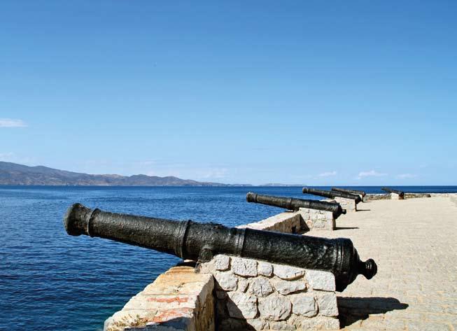
Old canons in the port of Hydra (photo Bradleycredit:Griffin)
Naturally, Hydra’s maritime history occupies a prominent place in the island’s museums and mon uments For example, in the Historical Archive-Mu seum of Hydra are exhibited ship prows, nautical charts and documents, paintings with depictions of Hydra ships and portraits of ship owners and cap tains, while various maritime relics are located in the Annex of the National-Historical Museum “La zaros Kountouriotis”, which is housed in the former home of the famous Hydraian notable
An important element of local maritime tradition is the Hydra Merchant Marine Academy, the oldest maritime school in the country It was established in 1749 as a school accommodated in the precincts of the Agios Vasileios church From around 1800, it operated under the supervision of the island’s De mogerontia as the Hydra Naval School, where na val theory and practice, as well as foreign languag es, were taught, producing a significant number of qualified personnel, who were also to contribute to the fighting val ue of the Hydra fleet during
26
nos are some of the most noteworthy examples Also, the financial contribution of the well-to-do Hy draians to the national liberation struggle was very importantDespite the gradual decline of merchant shipping and the emergence of new seaports in the Greek State, the Hydraians did not stop dealing with mari time trade and fishing, while they also turned to the sponge industry, whereby they acquired a consider able fleet, especially during 1920-1940
the Greek Revolution In 1927 it came under the care of the Hydra Seamen’s Union and operated as a private institution, but in 1930 it became stateowned under the name “Hydra Merchant Marine School” Since then, it has been housed in buildings that belonged to the Hydra ship owners and cap tains Anastasios Tsamados and Athanasios Koulou ras, while more than 3,200 officers have so far graduated from it Today there are about 150 stu dents, both men and women
Apart from the imposing traditional houses of the Hydra shipwrights, the lighthouses of the area are also worth mentioning The lighthouse in Zour
va, erected in 1883, is located on a rocky site in accessible by land It was destroyed by the Ger mans in World War II and rebuilt in 1946 . Its tow er is square, 10 metres high with a a focal height of 36 metres Also, the Dokos lighthouse was orig inally built in 1923, but suffered major damage in 1941 and was essentially rebuilt in 1945; it has a 9 metres high circular tower, while its focal height is 23
Nowadays,metres
27
there are several popular local events related to aspects of Hydra’s maritime history and tradition The Miaoulia are held every June in honor of Andreas Miaoulis and last three days; they include a variety of cultural events and boat races, while culminating in the re-enactment of the victori ous naval battle of Gerontas (1824) Kountouriotia is organized every August in honor of Admiral Pav los Kountouriotis, scion of the island’s historic family, an emblematic figure of the Greek Navy and first President of the Hellenic Republic
Finally,backthe
and visitors The “Hellenic Re vival-Hydra” race takes place at the end of March and the “Hydra” race at the end of October; both consist of two courses of 36 nautical miles, from Faliro to Hy dra and
Although almost uninhabited today, the small island named Dokos is located in the narrow passage between Hydra and Hermione The earliest human presence dates back to the Neolithic era . It is a
Under the auspices of the Municipality and the Water Nautical Club, two sailing races are held every year, which are connected to the two nation al anniversaries and attract a large number of boats
The Hydra Merchant Marine Academy
annual Hydra Maritime Conference is organized by the Hydra Brotherhood of Athens and attended by members of the Greek maritime community, executives of shipping and related com panies, as well as representatives of the Ministry of Shipping and Insular Policy, with the aim of ex changing views on the course of the of Greek ship ping Although the modern economy of Hydra is based primarily on tourism, some of its inhabit ants are engaged in fishing The island, the port of which is used by 49 professional fishing boats, fea tures a professional fishing association and two fish ing harbors [DK]
Pausanias (2, 34, 10) mentions Dokos as “Aperopia”, which means the one that looks to wards infinity, a name that apparently arose from the view that can be enjoyed at the highest points of the island It was probably named “Dokos” during the Byzantine era, as it was a passage for Hydra and nearby Hermione During the Rev olution of 1821, the island was used as a winter anchorage for Greek warships, while in recent years it was sporadically inhabited by shepherds, loggers, fishermen and quarrtymen, as Dokos has marble deposits In addition, in the sheltered anchorages of the northern coast, sponge ships were also wintering
Right: "Marin d' Hydra" (Belle 1881, 7)
an The area of the shipwreck is today a declared marine ar chaeological site and is pro tected by the relevant legisla tion, while the entire Skidos Bay is a popular sum mer anchorage for recreation boats
28
In 1923, the lighthouse of Dokos was built on a hill in the south-eastern part of the island It is made of local marble, its tower is 9 metres high, while its focal height is 23 [AL]

View of Dokos
rocky, mountainous island with few water sources Nevertheless, habitation in Dokos intensified during the Early Helladic period as a result of its strate gic location on the sea routes connecting the Sa ronic with the Argolic Gulf and the Argolic coast with the Cyclades, and its consequent involvement, through seafaring, in exchange networks that devel oped in the area during the 3rd millennium A typ ical example of this maritime mobility is the ship wreck that was found in 1975, at the bottom of Skidos Bay, in the north-eastern part of the island The excavation of the remains, which was the first systematic underwater investigation of an ancient shipwreck in Greece (1989-1992), brought to light two stone anchors and large quantities of pottery and tools, but the remains of the ship itself could not be located According to the archaeological finds, the shipwreck dates back to around 2200 BC and they clearly indicate that it was a merchant ship, carrying goods Among them were blades and cores of Melian obsidian, the much sought-af ter stone throughout the course of prehistory in the Aegean and the Eastern Mediterrane
29

Stavrolakes, N 1979, Poros, Athens Taylor, M 2013, Salamis, island and battle of, in The Encyclopedia of Ancient History, Malden, Tomkinson,6016-6017JL 2013, Travels in the Saronic Gulf: with Troezenia and Kythera, Athens
Γιαγκάκης,
Jones, A 2017, A portable cosmos: revealing the Antikythera Mechanism, scientific wonder of the ancient world, Oxford
30
Lear, E 1863, Views in the Seven Ionian Islands by Edward Lear, London McGilchrist, N 2009, The Argo-Saronic islands: Salamis, Aegina, Angistri, Poros, Hydra, Spet ses, London
Mee, Chr & Spawforth A 2001, Greece: an ar chaeological guide, Oxford Ottaway, M 1998, The most beautiful villages of Greece, New York
Barber, R 1999, A guide to rural Attika, Athens Bell, H 1881, Trois années en Grèce, Paris
Γ. 2007, Πόρος, τ’ ωραίο νησάκι νάτο! Ένα οδοιπορικό στο χθες μέσα από σπάνιες φωτογραφίες και λογοτεχνικά κείμενα,
Hornblower, S & Spawforth A 2012, Salamis, in The Oxford Classical Dictionary, 1309 Hornblower, S & Spawforth A 2012, Troezen, in The Oxford Classical Dictionary, Oxford Uni versity Press, Oxford, 1511
- άλλοτε και
Bibliography
Ανανιάδης,
Vanges, P D 1993, Kythera, a history of the is land of Kythera and its people, Sydney South Walter, H 2001, Ο κόσμος της αρχαίας Αίγινας: 3000-1000 π.Χ., Αθήνα
ο
West, W 2013, Methana, in The Encyclopedia of Ancient History, Malden, 4 475-4 476
Freely, J . 2008, Kythera, in The Ionian Islands: Cor fu, Cephalonia and Beyond, London, 207-232
Αγγελίδης, Χ., Γεωργιάδης, Ν., Κορδοπάτης, Π., Πορτόλου, Δ., Τσιόπελας, Ν. 2016, Καταγραφή και αξιολόγηση του φυσικού περιβάλλοντος Κυθήρων και Αντικυθήρων,
Fawssett, J 1988, Saronic Gulf islands and Ky thera, New York
Forbes, H 2007, Historical background to the landscape of Methana, in Meaning and iden tity in a Greek landscape: an archaeological ethnography, Cambridge, 50-96
Gaukroger, L 2013, Troezen, in The Encyclope dia of Ancient History, Malden, 6873-6874
Γ. 2014, Πόρος, Τροιζηνία, Μέθανα. Με το βλέμμα των περιηγητών: μια περιήγηση στον τόπο και στον χρόνο, Πόρος Ακρίτας,
Goette, H R 2001, Athens, Attica, and the Meg arid: an archaeological guide, New York
Bevan, A & Connoly, J 2013, Mediterranean is lands, fragile communities and persistent land scapes, Antikythera in long-term perspective, Durell,CambridgeL1978, The Greek islands, London
Aθανασίου,Πόρος Τ. 1957, Μέθανα: Η ιστορική χερσόνησος - γύρος της χερσονήσου, Αθήνα Δ. 2008, Κύθηρα - Αντικύθηρα -Ελαφόνησος, Αθήνα Γ. 1996, Το Αγκίστρι του Αργοσαρωνικού τώρa, Αγκίστρι
Wordsworth, Chr 1871, Greece, pictorial, de scriptive and historical, London
Aθανασίου,Αθήνα
Figueira, T 2004, The Saronic Gulf, in Hansen M H & Nielsen T H (eds ), An Inventory of Greek Poleis, Oxford/ New York, 620-623
Δόδουρας,Αθήνα
Μηνακάκης, Β. 2002, Αργοσαρωνικός, Αθήνα
Δεσύπρης,Αθήνα
Καλός, Γ. 2011, Τροιζήνιος Θαλασσό Πόρος,
Π. 2004, Ανεξερεύνητες Σπέτσες, Ε. & Γιαννιώτης, Π. 2016, ΚύθηραΑντικύθηρα, Χατζηδημητρίου,ΚύθηραΤζ.2008, Ανεξερεύνητα Κύθηρα - Αντικύθηρα, Αθήνα Χριστοδούλου, Χρ. 1989, Η ιστορία της νήσου Ύδρας από την αρχαιότητα μέχρι σήμερα, Ύδρα
Λώλος, Γ. 2006, Ύδρα - Δοκός - Νησίδες και βραχονησίδες - Σπέτσες, στο Βλαχόπουλος, Α. Γ. (επιμ.), Αρχαιολογία: Νησιά του Αιγαίου, Μέλισσα, Αθήνα, 192-197
Χαρχαλάκης,Αθήνα
Σ. & Λυρατζάκη, Ε. 20172, Καταγραφή και αξιολόγηση των πολιτιστικών χαρακτηριστικών Κυθήρων και Αντικυθήρων, Αθήνα
Γ. 2004, Σπέτσες, χθες και σήμερα,
Γιαννοπούλου, Μ. 2018, Αρχαία Τροιζήνα, Αρχαιολογία και Τέχνες 127, 112-144
Δεσύπρης, Γ. 2002, Αργοσαρωνικός, Αίγινα, Πόρος, Ύδρα, Σπέτσες, Αγκίστρι, Σαλαμίνα, Αθήνα
Δεσύπρης, Γ. 2004, Πόρος, χθες και σήμερα, Δεσύπρης,Αθήνα
Γ. 2004, Ύδρα, χθες και σήμερα,
Κατσούρα,Αθήνα
31
Δεσύπρης, Γ. 2004, Αίγινα - Αγκίστρι, χθες και σήμερα, Αθήνα
Ε. 2017, Η προϊστορική Τροιζήνα, Αρχαιολογία και Τέχνες 125, Αθήνα, 52-62 Κουτούζης, Β. 2000, Καλαυρία-Σφαιρία, Πόρος, Τροιζηνία, Πειραιάς Κουτουζής, Β. 2002, Η ιστορία της Τροιζηνίας, Λώλος,ΠειραιάςΓ. 2006, Σαλαμίνα - Ψυττάλεια, στο Βλαχόπουλος, Α. Γ. (επιμ.), Αρχαιολογία: Νησιά του Αιγαίου, Μέλισσα, Αθήνα, 176-181
Μιχαλόπουλος, Α. 2000, Τα μουσεία της Ελλάδας: Αττική και νησιά Αργοσαρωνικού, Αθήνα
Νιάρχος, Θ. (επιμ.) 2008, Λόγος για την Ύδρα, Νικολακάκης,Αθήνα
Χ. Μ. 1963, Περί της νήσου των Αντικυθήρων, Θεσσαλονίκη Παντελή, Θ. 2003, Σαλαμίνα, πορεία στον χρόνο, Πυλαρινός,ΑθήναΘ.(επιμ.) 2007, Ιόνιοι Νήσοι: ιστορία και πολιτισμός, Σημαντώνη-Μπουρνιά,ΑθήναΕ.
2006, Αίγινα - Πόρος, στο Βλαχόπουλος Α. Γ. (επιμ.), Αρχαιολογία: Νησιά του Αιγαίου, Αθήνα, 182-191 Σημαντώνη-Μπουρνιά, Ε. & Μενδώνη, Λ. (επιμ.) 1998, Αρχαιολογικός άτλας του Αιγαίου: από την προϊστορία έως την ύστερη αρχαιότητα, Σουλιώτης,Αθήνα Γ. 2006, Ο Πόρος είναι..., Αθήνα Σταμάτης, Κ. 2008, Αίγινα: ιστορία και πολιτισμός, Σφυρόερα,Αίγινα Σ. 2002, Αίγινα, πρώτη πρωτεύουσα της νεότερης Ελλάδας, Αθήνα Τσαραβόπουλος, Ά. 2006, Κύθηρα - Αντικύθηρα, στο Βλαχόπουλος, Α. Γ. (επιμ.), Αρχαιολογία: Νησιά του Αιγαίου, Μέλισσα, Αθήνα, 198203 Τσαραβόπουλος, Ά. 2015, Αντικύθηρα: ταξίδι στην ιστορία του μικρού νησιού, Αρχαιολογία και Τέχνες 119, 20-35 Τσιτσίλιας, Π. 1993-1994, Η Ιστορία των Κυθήρων, Αθήνα Τσουνάκος, Ό. 2008, Τροιζήνα: Οδοιπορικό στο χρόνο και στον τόπο, Ελληνικές Εκδόσεις, Χαριτάτος,Αθήνα
Α. 2007, Δρόμοι Σπετσών, οδηγός πορείας, Αθήνα Κιούσης, Θ. 2018, Ύδρα, Αθήνα Κίτσος, Δ. & Πατσιάδου, Λ. 2021, Νησιά της Αττικής, όψεις της ιστορίας και του πολιτισμού, Κονσολάκη-Γιαννοπούλου,Αθήνα


978-618-82380-1-5ISBN:
Co-funded by the Greek State and the European Union in the contex of the Operational Programme “Maritime & Fisheries 2014-2020”


OFFREEDISTRIBUTEDCHARGE
