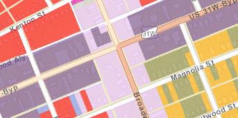
ZONING The zoning map shows you the current zoning of the land. In other words, the type of development currently allowed in that area.
SECTION 2: WHAT IS ZONING? Zoning is used to implement the comprehensive plan and is the separation of land into categories such as residential, commercial, industrial, etc. Each zone has different regulations that dictate things like the size of building and types of activity allowed. Development projects must meet all the regulations for the zone in which they are located. These regulations are often called zoning ordinances, zoning codes, or land development codes. For Bowling Green, KY, these regulations can be found in the Zoning Ordinance. To find out the zoning of a property in Bowling Green, you can go online to https://warrenpc.org/webmaps/ and click on planning and zoning. This website includes various maps as well as videos on how to use them. Some of the basics about the planning and zoning map are below. At the top right corner of the screen you will see a toolbar and the second option on the toolbar will bring up the layers where you can select what you want to show up on the map.
In the planning and zoning layers, there are three layers that seem similar, but their distinction is important. Those are zoning, existing land use, and future land use. To the right you’ll see an example of each for the intersection of 31W and Broadway.
EXISTING LAND USE Existing land use shows you the current use of a property and this does not always match the zoning.
FUTURE LAND USE
The future land use map, commonly referred to as FLUM, shows the vision for the future of development and is derived from the comprehensive plan.
When a property’s existing land use does not match the zoning, it is called a non-conforming use. This happens when the current use existed prior to the adoption of the current zoning regulation. If redevelopment were to occur, the new development would be required to abide by current zoning and the existing use would be retired. If the developer wanted to rezone the property and the requested rezoning matched the future land use map, they would likely be granted the rezoning since it fits with the future vision of the city.
11


