10 minute read
Connecting the Parks

ADDING TRAILS & STRENGTHENING ACCESS Much of the trail and park network studied already exists, and more is planned, including a spur from the Towpath Trail to connect with the Treadaway Creek trail. However, there are other gaps in the trail network that the charrette participants explored, indicated in the dashed lines; and smaller-scale neighborhood entries or overlooks into the park system were explored.
Advertisement
The following spreads illustrate how an urban explorer might venture from the Towpath Trail in the Cuyahoga Valley into this southern parks system - to Harmody Park, Brighton Park, the Metroparks Zoo, and Brookside Reservation - and at what points in this network there may need to be stronger physical improvements in order to maintain their continuity in the system.
Additionally, improving connections from this network into its adjacent neighborhoods will be crucial. The two primary points of access requiring stronger entries are indicated above in the largest bubbles: the intersection at Fulton/Denison; and the crossing at Pearl Rd just south of the Metroparks Zoo. Other, smaller-scale entries can also help increase access, use, and awareness.


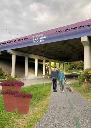
TOWPATH TRAIL TO TREADAWAY CREEK The Towpath Trail connects over 100 miles of Northeast Ohio and runs just east of Old Brooklyn in the Cuyahoga River Valley. Its current linkages into Old Brooklyn, however, are unmarked and univiting (RIGHT). Adding colorful art, landscaping, signage, and clear trail wayfinding (TOP) indicates to visitors that safe and attractive parks lie just beyond.


TREADAWAY CREEK TRAIL TO HARMODY PARK The Treadaway Creek Trail leads from the Cuyahoga Valley up into the Old Brooklyn neighborhood at Harmody Park, and is a beautiful and important connector. However, its entries - both at the Valley and Harmody Park ends - are not well-marked or inviting. Adding colorful and well-lit public art, in conjunction with wayfinding, brings visitors up from the Valley into the neighborhood.
Additionally, Harmody Park itself seems ripe for improvements, both in active and more passive recreation. Ideas for making Harmody Park feel a more seamless component of the Towpath-to-Brighton connection are at left.

SHORT-TERM: Trail striping for bike lane MID-TERM: Integrated on-road multiuse trail


LONG-TERM: Complete & Green Street
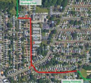
HARMODY PARK TO BRIGHTON PARK: BIKE BOULEVARDS The gap in connection between Harmody Park and Brighton Park, which runs through the Old Brooklyn neighborhood (RIGHT), could be filled with an on-street bike boulevard / multiuse path that still allows vehicular traffic for local homeowners. The existing street is shown at lower right; an on-street bike boulevard treatment could begin with a simple striping technique that plays with the familiar and well-recognized Metroparks Trail striping (TOP LEFT).
in a few years, the designated streets could add in more robust multiuse paths and some colorful signage (TOP RIGHT). Long-term, these streets could receive a complete and green streets treatment, including stormwater capture and rain gardens, in order to signify that these new types of urban streets are also part of a larger parks network (ABOVE).


BRIGHTON PARK As the Western Reserve Land Conservancy and Cleveland Metroparks complete initial construction on Brighton Park, a former landfill site, additional plantings, pathways, and light-touch seating and structural elements could be arranged along the pathways in clusters visible from each other. Explorers would be drawn along the pathways by the visual lure of new and unique installations, some of which could highlight natural play, pollinators, or unusual materials, like the examples shown above.

BRIGHTON PARK TO METROPARKS ZOO The area of Pearl Rd in Old Brooklyn adjacent to the new Brighton Park and south of Wildlife Way is the primary gateway into the south Cleveland Parks network, but the built environment here is not necessarily reflective of nearby recreational opportunities. TOP: New higher-density mixed-use development at this intersection can take on an explicitly Green character: green roofs, raingardens, bioswales, distinct street trees, landscaping, and other elements add to the larger story that this is where the Metroparks and the City come together.
Trail crossings can be powerful reorienting tools for visitors. Even in an urban context, some miminal but distinct graphic and crosswalk components help alert drivers and pedestrians to a new urban experience. RIGHT, the Indianapolis Cultural Trail, which traverses downtown, is clearly marked even when it crosses vechicular traffic, creating an alternative network to the existing street grid. Pearl Rd could receive something similar where the Trail crosses from Brighton Park to Wildlife Way.


METROPARKS ZOO TO NEIGHBORHOODS The Metroparks Zoo, while well-used and well-loved by the larger Cleveland region, contributes to the separation between the Brooklyn Centre and Old Brooklyn neighborhoods. The Zoo is fenced off for security reasons, and this, in addition to existing rail and water infrastructure, makes traversing the Big Creek ravine difficult. This privacy does help the Brookside/Zoo system feel set apart from its urban surroundings, but it also further divides the city.
The Pensacola Steps on the south side of Wildlife Way are a lovely existing connection to the Old Brooklyn neighborhood, but they are fairly tucked away. Expanding access and visibility across the parkway could help the Zoo feel more a part of the neighborhood (TOP). On the North side of the Zoo, in the Brooklyn Centre neighborhood, if true physical connections are not possible due to existing infrastructure, dead-end neighborhood streets could be transformed into well-lit and well-marked overlooks for residents to look down into the Zoo and observe the animals below (LEFT).

VERTICAL CONNECTIONS One of the primary barriers to connecting into and out of Brookside Reservation is the steep natural topography around the Big Creek Ravine. A few vertical connections do already exist in and around the Park: the Pensacola Steps, from the Old Brooklyn neighborhood north to Wildlife Way (RIGHT); and an in-park WPA-era staircase and overlook (BOTTOM RIGHT). Using these vertical connections as inspiration, additonal overlooks, ramps, bridges, and staircases could connect at key points along the southern bluff, as shown in the map below. Though accessibility can be a challenge with staircases, broadening the palette of vertical connections can make the full range of Parks activities available to more visitors. OPPOSITE, the Tetsuo Kondo Pathway in Kadiog Park served as inspiration for a similar catwalk installation on the Brookside Bluffs.


LIGHTING ART Along the trail network and at key points in the parks, integrating lighting art throughout creates a cohesive sense of place and attracts neighbors to keep exploring. TOP, linear sculptural elements might light up whenever passers-by touch them, encouraging interaction. BELOW, examples of lighting art that highlight landscape and trail elements in urban places.


STORMWATER MANAGEMENT Big Creek, which flows through Brookside Reservation, is known to occasionally flood. The parking lots adjacent to Big Creek are currently slated to receive green infrastructure retrofits, but the entirety of the broad floodplain area of Brookside could also become a showcase for a variety of stormwater management techniques. Some of the ideas shown above include terracing the banks and building overlooks into the Creek to highlight publc access to the water itself, and adding a large circular infiltration basin in the open field between the baseball field and the zoo shuttle area.

RAILROAD BRIDGE IMPROVEMENTS The north side of Brookside Reservation is currently only accessible to the Brooklyn Centre neighborhood under a railroad bridge by the back service area of the Metroparks Zoo. Park visitors might not even realize that the bridge, quite a beautiful structure, is there and open to the public. Creating a series of zoo-themed art and lighting installations along this “back door” from Brookside north to the Denison/ Fulton intersection would lead visitors on a more cohesive and welcoming path from the valley floor below the dividing infrastructure and into the neighborhood beyond.


BROOKSIDE STADIUM The historic Brookside Stadium on the southwest intersection of Fulton/Denison, in the Brooklyn Centre neighborhood, is a natural bowl that can act as an amphitheatre. Currently the space, a baseball field, is underutilized and routinely holds standing water in its field.
Terracing shown above and at left, built into the natural hillside, creates a more formal series of spaces for recreation and entertainment. In the long term a canopy amphitheatre structure could shelter performances and seasonal activities like ice skating. At the top of the terraced area, a larger hardscaped plaza hosts pop-up events, food trucks, festivals, and other high-visibility activities that invite neighbors down the hill to the park below.

BROOKSIDE TO BROOKLYN CENTRE The Fulton Bridge, which spans across Brookside and connects the Old Brooklyn neighborhood to Brooklyn Centre and ClarkFulton, is an essential link from the Parks network to the larger city. However, the sidewalks that currently serve pedestrians, along the bridge itself and particularly at the intersections north and south of the bridge (Fulton/Denison and Fulton Parkway/Park Dr), are narrow and treacherous next to higherspeed traffic. As the parks are connected via a cohesive trail network to each other and to the Towpath beyond, safe and inviting pedestrian and bicycle infrastructure is crucial. The drawings shown here illustrate retrofits that include landscape buffers, clear crosswalks, paving treatments, lighting, and clear signalization to emphasize safety for all modes of transit.
FULTON BRIDGE: CURRENT FULTON BRIDGE: PROPOSED


FULTON/DENISON: CURRENT FULTON/DENISON: PROPOSED


FULTON PARKWAY/ PARK DR: CURRENT FULTON PARKWAY/ PARK DR: PROPOSED


