


Emerging technologies pose significant opportunities for the landscape sector to grow, thrive and contribute its expertise. It is incumbent on all of us to engage and seize this opportunity together.
Rob Hughes CEO, Landscape Institute
Find out more on page 64
In today’s world, it can be easy to synonymise ‘digital’ with ‘technology’. But following Sam Bailey CMLI (p39), technology is a far broader term, encompassing the digital, mechanical, material and biological, in “the application of scientific knowledge for practical purposes, especially in industry.”
How digital technologies integrate with other forms of technology, as well as other forms of life and nature, is what gives them their strength. It’s also what makes them so effective at bringing industries together in sight of shared goals – whether that be decarbonisation, environmental net gain, or community engagement. This ‘Digital’ edition of the journal explores how these technologies can be harnessed to progress the landscape profession, aid better collaboration and improve outcomes for people, place and nature.
“Central to this process is translating multidisciplinary inputs into a common language – data,” we learn from McGregor Coxall (p32). But “the primary challenge [for] landscape practice lies in the unique intrinsic characteristics of landscapes,” says Giuliana Santos (p20) and the fact that “access to digital networks depends on who you are, where you live, what you can afford and the government you live under,” says Ed Wall (p15).
This perspective puts digital technologies at an emergent front between the arts, sciences and built and natural environments. It is therefore vital that landscape professionals are the ‘synthesiser’
(p12), so that the outcomes are landscape-led.
This edition of the journal follows on from the success of the Digital Practice & Technology for Landscape conference in July this year, the Landscape Institute’s (LI) first in-person conference since the pandemic. The LI extends its thanks to all the speakers and attendees on the day, as well as those who have contributed articles here, in particular the members of the LI’s Digital Practice working group and its chair, Mike Shilton CMLI, whose knowledge and input have been invaluable.
Josh Cunningham Managing Editor

PUBLISHER
Darkhorse Design Ltd
T (0)20 7323 1931 darkhorsedesign.co.uk tim@darkhorsedesign.co.uk
EDITORIAL ADVISORY PANEL
Saira Ali, Team Leader, Landscape, Design and Conservation, City of Bradford Metropolitan District Council
Stella Bland, Head of Communications, LDA Design
Marc Tomes CMLI, Director, Allen Scott Landscape Architecture
Sandeep Menon, Landscape Architect and University Tutor, Manchester Metropolitan University
Peter Sheard CMLI, Landscape Architect
Jaideep Warya CMLI, Landscape Architect, Allies and Morrison
Jane Findlay PPLI, Director FIRA Landscape Architects
LANDSCAPE INSTITUTE
Managing Editor and PR & Communications
Manager: Josh Cunningham josh.cunningham@landscapeinstitute.org
Proof Reader: Johanna Robinson
President: Carolin Göhler
CEO: Rob Hughes
Head of Marketing, Communications and Events: Neelam Sheemar
Director of Policy & Public Affairs: Belinda Gordon
Landscapeinstitute.org @talklandscape landscapeinstitute landscapeinstituteUK
Print or online?
Landscape is available to members both online and in print. If you want to receive a print version, please register your interest online at: my.landscapeinstitute.org
Landscape is printed on paper sourced from EMAS
(Environmental Management and Audit Scheme) certified manufacturers to ensure responsible printing.
The views expressed in this journal are those of the contributors and advertisers and not necessarily those of the Landscape Institute, Darkhorse or the Editorial Advisory Panel. While every effort has been made to check the accuracy and validity of the information given in this publication, neither the Institute nor the Publisher accept any responsibility for the subsequent use of this information, for any errors or omissions that it may contain, or for any misunderstandings arising from it.
Landscape is the official journal of the Landscape Institute, ISSN: 1742–2914
© 2024 Landscape Institute. Landscape is published four times a year by Darkhorse Design.


Redefining the relationship between urban spaces and the ecosystems that sustain them with McGregor Coxall. Find out more on page 32.
FEATURES
8

The lay of the land: A landscape perspective on artificial intelligence
Denise Chevin looks at the implications of AI for the sector
20

Seeing double: The landscape of digital twins
Applications of digital twins in landscape practice

31 Conference insight: Golden rules for landscape BIM modelling
Key takeaways for landscape professionals
15

Imperfect forms of public space – even in a digital age
Ed Wall provides insights from the University of Greenwich Centre for Spatial and Digital Ecologies
18

Yukako Takanashi argues that data centres can be sites that contribute to nature recovery A landscape-led approach to data centre design
25
Digital Frontiers: Reshaping landscape through data CASE STUDY CASE STUDY

Pioneering work at the Queen Elizabeth Olympic Park
26

Scoop behind the foliage: How information shapes landscape
Thomas Yunqing Bai on the data revolution
Living Infrastructure: A digital approach to urban ecosystems 32 CASE STUDY

McGregor Coxall’s Biourbanism Lab is transcending disciplinary silos to address complex urban challenges


Three industry perspectives on key technologies for implementing Biodiversity Net Gain (BNG)

Insights on key technologies for reducing project carbon, from the Landscape Institute Landscape and Carbon Steering Group


Denise Chevin sets out the basics of artificial intelligence, explores its application in landscape practice and highlights implications for the future of the profession.

1. AI-assisted rendering of landscape project.
Credit: Nick Tyrer
From smart assistants like Amazon’s Alexa to spam filters on your email, to online chatbots and robotic vacuum cleaners, artificial intelligence (AI) has been incrementally impacting our everyday lives without many of us even registering it.
Over the past 18 months these advances have been moving at warp speed, with the development of
so-called generative AI. New tools are fundamentally changing the way creative professionals work –landscape practitioners included.
Generative AI, in the form of ChatGPT, Microsoft Copilot and image creation models like Midjourney, DALL-E3 and Stable Diffusion, to name a few, has the potential to provide huge efficiencies in concept design and is taking the strain of more
administrative activities like generating reports and writing submissions.
Coupled with other still-embryonic software, this offers huge potential in devising and planning landscape in consideration of biodiversity, climate and soil conditions. These tools can potentially help streamline workflows, reduce costs and ensure that the design is environmentally sound. The prospect is being met in the landscape

community with an understandable mixture of trepidation about job security and excitement at the creative possibilities it offers and so at this stage its use comes with a health warning: AI in all its formats should be used as a starting-off point, not a panacea.
“We’re in the full-on experimental phase, where most people are playing with off-the-shelf products to see what’s possible,” says Phil Fernberg, Director of digital innovation at USbased landscape consultancy OJB and a member of the American Society of Landscape Architects, who holds a PhD in AI and landscape architecture. “But as far as full business transformation or workflow integration, that’s still in the beginning. People are still trying to figure out how to use it.”
So what is artificial intelligence?
AI is software that can analyse large amounts of data, recognise patterns and make predictions or decisions based on that data, continuously improving its performance over
time. According to Fernberg, “AI is a whole umbrella of different ways of approaching automation and there are different ways of conceptualising and characterising it. One way is according to its abilities, of which there are three categories.”
These categories are, firstly, artificial ‘narrow intelligence’, which is the capability to perform a discrete task or a discrete set of tasks – like virtual assistants. Secondly, artificial ‘general intelligence’ is where it’s getting into the ability to perform generally on a wide range of tasks, just as humans would in novel environments and novel contexts and at the same rate as humans, like driving a car and this is still a work in progress. And then, thirdly, there’s artificial super intelligence, where it surpasses that of humans and is still in the realms of science fiction.
“When most people talk about AI these days they are talking about generative AI – so that’s programs like ChatGPT, DALL-E and Midjourney,” says Fernberg.
These types of programs are still classified as ‘narrow intelligence’ but operate at a game-changing level. They use deep learning from vast amounts of data taken from the internet (or internal documents) to analyse and understand text or images and then generate their own output based on prompts provided by the user.
Alan King, head of global membership development at
When most people talk about AI these days they are talking about generative AI –so that’s programs like ChatGPT, DALL-E and Midjourney.


IMechE and founder of AIYourOrg. com, says, “If you’re asking AI to generate a picture of a cat, it’s looking at millions of pictures of cats and then asking itself, ‘What does a cat look like?’ Then it creates an image that it thinks answers your question.”
When it comes to landscape images, generative AI programs
can generate multiple design variations, exploring numerous possibilities based on parameters like space constraints, environmental conditions and aesthetics. For landscape designers, bespoke software is being developed in the form of plug-ins to existing design that can help create optimised outdoor
environments, adjust landscape layouts quickly, or create planting plans and assess irrigation needs.
‘Democratising’ landscape design
Such is the speed of development that it’s off-the-shelf general programm that have been shaking up the design sphere because they are so easy to use.
Nick Tyrer is a practice leader in computational design and research at BDP Pattern, the sports and entertainment division of BDP. An architect by training, he has been using generative image tools like Midjourney to help create concepts for competition submissions where requirements are visual rather than necessarily requiring full landscape considerations.
“The AI image-generating tools are very good from a designer’s perspective, whether you’re an architect or a landscape designer. You can open the program and just start describing what you want and it will generate an image, based on your prompts. It might not be what you want, but it might be close and you can just keep honing it with more prompts. Alternatively, you can use it just for inspiration.”
Tyrer finds that current constraints are to do with biases in training data and potential reinforcement of existing stereotypes. For architects, that amounts, for example, to a prevalence of American-style architecture in AI-generated images of houses. He warns that, used naively, the tools can lead to a false sense of creativity and the designer simply presenting random, unoriginal content.
Tamae Isomura, senior landscape architect at Ground Control, echoes many of these sentiments from her experience of experimenting with AI tools. She observes how generative AI is a potential threat to the work of landscape designers, but is also providing benefits.
Ground Control is a design and build contractor which works entirely digitally, using traditional computer aided design (CAD), Geographical Information Systems (GIS) and 3D modelling. Plants are included in BIM models, specifying the plant species
and Autodesk’s Revit is also used for planting plans.
Isomura says that they are using image-based generative AI mainly for concept development, brainstorming with the software to generate ideas, as well as improving design statements and identifying areas for improvement based on previous projects. The company is also testing Microsoft Copilot Pro, which can be customised by scanning and searching internal documents saved on the company server. In practice, Isomura says you might prompt the tool to write up the design statement from the rendered plan or drawings, which would produce a basic structure of the concepts and description. You might then ask how the design might be improved and the AI would search previous projects from the internal files saved on the server and suggest various ideas.
“It is useful as a time-saving tool. It’s not perfect but the pace of improvement at the moment is dramatic so we can see the potential,” she says.
Isomura also sees some potential downsides – and is concerned that AI could tempt some practices to replace junior roles in design, particularly in
the early stages of projects, such as pre-planning concepts where the landscape professional’s input is often visual.
She also observes that Ground Control often finds that they will have to redesign schemes at the construction stage if the visual concepts are generated by others using AI without any landscape qualifications. “It might be that because of the retaining wall, the planting doesn’t work in a given area, because of the soil conditions or the micro-climate.”
Isomura adds that it is possible to use AI for planting while also taking into consideration the site conditions and site layout scenarios, but it needs to be validated by experts.
“For me, the important thing is that landscape practices do not replace the junior landscape architects with AI, because we need to develop the future generations to have human intelligence. We need to give people the opportunity to learn.”
Designers across the board flag up the issue of copyright as another major concern. Fernberg says the unattributed use of imagery has become like the “wild west”. He and
others point to general confusion, user terms evolving on the hoof and the need for clear legal frameworks to be developed.
As well as the ethics of intellectual property and of creativity and creative agency in the design process, another worry for some is the environmental implications. “The data centres powering generative AI models are power hungry and therefore carbon intensive,” says Fernberg.
There is an industry consensus that AI can be a useful assistant. But with all parts of the design process being pervaded in some way by AI, there is also a strong general view that it will only be a matter of time before these systems are joined up and the whole design process becomes more automated, with designers acting in the role of ‘’synthesiser”, as Fernberg describes it.
“You won’t see it for a while, but what you will see is that some of those individual elements of the design process will be made far more efficient and completely transformed. And they’ll link in with systems that were already around even before
4. AI-generated planting image, generated in Midjourney with prompt: landscape architecture, planting bed, rudbeckia, buxus, lavender, rosemary, trees.
For me, the important thing is that landscape practices do not replace the junior landscape architects with AI, because we need to develop the future generations to have human intelligence. We need to give people the opportunity to learn.


generative AI – like parametric design and greater machine learning models for spatial data – to transform the entire design process.”
Professor Andy Hudson Smith, from the Centre of Advanced Spatial Analysis at UCL, paints a similar picture. One of the projects he is involved with is converting Met Office data into written text and using AI to generate landscape images, to understand what AI can create from data feeds and whether it can generate realistic representations.
“The technology is advancing monthly. If you’re a landscape designer, you might cut and paste your client’s brief into an AI program and see what it comes up with. And it will probably come up with something which is wrong. But roll forward two or three years and it’ll probably come up with the plans, the drawings, look at the long-term flooding and storm water management, drought-resistant planning, carbon footprint and write your client report at the same time.”
“What is also attractive about generative AI is you can write software yourself. I’m an urban planner with a geography-based background, yet I can write software using ChatGPT and ask it to build the things that I want to do. So suddenly you become the expert in almost all things, because you can build the software.”
Alan King is also convinced of the huge impact AI will inevitably have.
“As we go forward, these models are going to become supercharged,” he says. “Most AI systems require a lot of human interaction and input and prompting to get to the kind of output you might desire. But over the next five to ten years, the capability is going to get better exponentially, with AI programs solving tasks together and taking humans out of a number of steps in the loop.”
“So you might produce a photograph of the land that needs to be developed, ask it to develop five possible designs and it will go away and do that. It will cost it, tell you
Carry your projects through from start to finish with the speed and reliability you require. With the latest in Vectorworks, you’ll find faster workflows at every stage of design, minimising interruptions and maximising productivity.
Start your free trial at VECTORWORKS.NET
where you can get all the materials you need and will pull the whole project together and give you the finished plan. And then it will be a case of choosing which one you’re going to work with.”
It seems that the industry is set to change significantly in the years ahead. But while much of what has historically been the job of a landscape designer may become automated, currently the expertise, skill and intelligence of a human would still be essential for choosing which of those five possible designs would be best. As long as that is the case, it will remain essential that landscape professionals are trained, educated and engaged in the process, so that the outcomes of projects are landscape-led. As Dr Fernberg says, it’s about being the synthesiser.
Denise Chevin MBE is a freelance writer and editor specialising in the built environment and is a former editor of Building Magazine.
What is also attractive about generative AI is you can write software yourself.


¹ https://www. routledge.com/ Contesting-PublicSpaces-Social-Lives-ofUrban-Redevelopmentin-London/Wall/p/ book/9781032163567? srsltid=AfmBOopt4cfK Zr2NucAzX8GoIoZULE
rrtTxFQbUbqSVHdwVe
W0_X8qx4
Through a series of vignettes, Ed Wall explores tensions across old and new public platforms, revealing the entanglement of spatial and digital ecologies and far-from-ideal forms of public space.
Ed Wall

How have public spaces changed? In recent work, I settled on defining public space as sites and practices of coming together around issues of concern¹ – places that are inclusive of the social and spatial relations of streets and squares, cafes and pubs, town halls and libraries, newspapers and television news, political meetings and violent protests. While none of these are perfect forms of public space, claims of some digital platforms as sites of free speech and emerging democracy require a rethinking of what public spaces can be.
Media
It has long been accepted that social media platforms create public spaces for coming together, sharing and debate. With the advent of platforms like Facebook, Twitter and Instagram, public space has expanded, like it did in the 17th century with the
innovation of printed newspapers. Published media disseminates issues of interest, it provides forums for people to come together and it has the power to hold business interests and elected officials to account. New ecologies of digital public spaces have been further formed as print media migrates to online platforms, leaving behind their declining print sales.
Despite fears that physical spaces of public discourse would also disappear into the web, in some UK cities over the last four decades the number of publicly accessible landscapes has grown. Many new forms of public space have also emerged, but these are often not the state-mandated forms of community parks and town

squares that we were familiar with in the UK up until the 1980s, or even through the New Labour government of the 1990s. Instead, we see largely privately owned public spaces financed by corporate interests and facilitated by local, metropolitan and national government.
There have long been varying forms of public space in cities like London where streets, squares and parks are owned and managed by the different councils, government departments, the Crown Estate, housing associations, commercial developers, private landowners and more. But when their terms of ownership and publicness significantly shift, it could be argued that these sites are no longer effective public spaces. They become seen as compromised platforms for governments or corporations to push partisan agendas that serve commercial interests. Concerns in the digital realm are similar. In 2022, Elon Musk claimed that Twitter was a ‘de facto public town square’ and that ‘Free speech is essential to a functioning democracy.’² When he acquired the platform, Musk fired content moderators in order to make speech less regulated. But as behavioural scientist Douglas Yeung wrote, ‘Firing all the rangers might let anyone walk into national parks, but trails would go unmaintained, trash would pile up, traffic would snarl and the majestic landscapes that attracted everyone to begin with would suffer.’³
The lack of regulation of big technology companies has left the publicness of their social media increasingly skewed. But as with historic tensions regarding physical public spaces or traditional news outlets, where self-regulation has long been argued for, governmentimposed controls raise concerns about free speech and independence. The nature of regulations and policing impacts publicness and the motives behind these controls can push them further towards a private realm. When journalists critical of Musk are excluded from X⁴ for reasons beyond the platform’s ‘terms of service’ the
publicness of this town square comes into question.
Much like the privately owned public spaces that dominate many contemporary cities, the private ownership of social media platforms –whether by individuals or corporations – makes a difference that many commentators struggle to reconcile with traditions of public space. But just because Musk bought Twitter and changed the name and rules for the social media platform, this does not preclude its presence as a public space. While all public spaces have restrictions placed on them, by varying combinations of governments, owners and managers, the rules also establish tensions which contribute to the contested politics that frequently plays out within these spaces.
Public spaces are of course not neutral containers of political activities or impartial platforms across which public life is performed. Whether in city halls or online forums, there are always limits to public spaces, from legal boundaries to digital surveillance cordons. To simultaneously advocate for free speech while restricting users of the platform to do so is a paradox, as we have seen play out across digital and physical realms. Public spaces are not free spaces and town squares have never been synonymous with free speech. To claim otherwise ignores long histories of public space exclusions, told through the experience of women, homeless people, marginalised groups and enslaved populations that have in the past been shut out of public life.

² https://x.com/ elonmusk/status/ 150777726165460582
8?lang=en
³ https://www. rand.org/pubs/ commentary/2023/01/ the-digital-town-squareproblem.html
⁴ https://newrepublic. com/post/177936/ twitter-suspendsaccounts-journalistscritical-elon-musk
⁵ https://placesjournal. org/article/a-city-is-nota-computer/#ref_34
⁶ https:/theconversation. com/jan-6-was-anexample-of-networkedincitement-a-media-anddisinformation-expertexplains-the-dangerof-political-violenceorchestrated-oversocial-media-220501
⁷ https://www. routledge.com/ Contesting-PublicSpaces-Social-Lives-ofUrban-Redevelopmentin-London/Wall/p/book/ 9781032163567?srsltid =AfmBOorH5rgI9L33Z fyEuGmpTV4PseHRXU XsZcqWYuRuzzvcSq O4-oVw

Public spaces are now designed, managed and used spatially and digitally: landscape architects plan simultaneously for CCTV surveillance and Instagrammable scenes; global events are broadcast from one city onto large pop-up screens in another; and everyday functions of waste collection and traffic control are managed with smart technologies and digital twins. But can digital be the answer to such a plethora of spatial problems? The writer Shannon Mattern cautions against such an embrace of digital technologies: ‘the city as computer’ she claims, ‘appeals because it frames the messiness of urban life as programmable and subject to rational order.’⁵ It is also unlikely that the inefficiencies of a public life that are produced through many diverse actions would survive the rational mind of computer scientists or the drive for profit of corporate owners.
We can recognise that digital technologies have accelerated public debate and public actions – online and on our town streets. Issues of concern, like violence that has disrupted communities, rapidly draws angry publics together, often to spill back into urban public spaces. What has been termed ‘networked incitement’⁶ can be seen around the world, including the role of social media platforms in the January 6 insurrection in Washington DC in 2021, or the UK summer riots in 2024. Events in public spaces, whether cultural celebrations or political demonstrations, have also recognised that digital platforms are essential to amplify their message or generate
more revenue. Political organisers know that photos of single protesters with bold signs are more attractive to media audiences than the issues around which public demonstrations form.⁷
Despite a spatial-digital hybridity evident in many urban public spaces, the planetary expansion of digital networks and what the philosopher Nancy Fraser terms ‘transnational publics’ points to further forms of spatial-digital public landscapes. Disparate networks of activists and communities, which come together to raise concerns around collective issues, from climate change to racial justice, define new public spaces. These constellations of public spaces have been facilitated by the expansion of digital networks and access to social media. They are frequently grounded in specific landscapes, where impacts such as those of global warming or racial discrimination are most pronounced. The entanglement of spatial and digital public spaces provides a means to form collective action while revealing the relations between where decision makers reside (usually capital cities), landscapes impacted by these decisions (frequently less visited places) and public sites of resistance (more visible city squares and media platforms).
Public spaces are unevenly distributed and not consistently accessible. The provision of public spaces between and within cities is rarely fair. Restrictions and regulations imposed on public spaces also vary between nation states. Access to digital networks and social media platforms depends on who you are, where you live, what you can afford, the government you live under, as well as the rules of engagement of each platform. X is a distorted form of public space – but so was Twitter before Musk bought it. And while in a space like Trafalgar Square, its relation to the state may limit public rights to access and protest, this does not make X a ‘de facto public town square’. Social media is just one of many public places where people come together to form publics – even when the ‘terms of service’ are inconsistently enforced.
Ed Wall is the director of the Centre for Spatial and Digital Ecologies at the University of Greenwich and a visiting professor at Harvard University. He is the author of Contesting Public Spaces: The Social Lives of Urban Redevelopment in London.

With an increase in demand for data comes an increase in demand for data centres. Yukako Takanashi highlights how a landscape-led approach can help these sites to contribute positively to local nature recovery strategies.

In the UK, there are over 500 data centres and the demand for data storage is continuing to escalate. The increasing use of cloud computing, big data analytics and digital services is driving high data storage and processing requirements, posing a challenge to industry and government.
According to Savills, the number of data centres will need to increase by almost 2.5 times by 2025 to meet the increased demand for storage in Europe.1 The Department for Science, Innovation and Technology (DSIT) recognises this growing demand for data storage, processing and digital services, whilet the new Labour government has designated data centres as Critical National Infrastructure,2 and the revised National Planning Policy Framework (NPPF) currently being consulted on emphasises that local planning authorities must make planning decisions that address the need for more data centres.3
However, data centres have a significant environmental impact, from energy consumption and land requirements to water consumption and ecological footprint. Reducing the overall consumption and carbon impact of data centres demands further research, design innovation and policy. Some progress is being made by major tech giants including Microsoft, Amazon and Google by sourcing energy from their renewables projects or through Power Purchase Agreements (PPA). For example,
Amazon’s wind farm projects in Bäckhammar and Microsoft's PPAs in Sweden and Denmark sourcie contracted electricity from wind and solar farms.4 But on a global systems scale, there is much work still to do.
So, what can landscape architects offer? Landscape design for large industrial sites has historically been driven by functionality and stringent security, serving the primary purpose of the facility. However, the design ethos for digital infrastructure is on the verge of significant change and landscape designers should play a key part in enabling these sites to become more outcomes-led, to make a positive difference to local nature recovery. Biodiversity Net Gain (BNG) is now a mandatory requirement in


1 https://www. savills.co.uk/ insight-and-opinion/ savills-news/336014-0/ savills--pipeline-ofdata-centres-needs-tomore-than-double-by2025-to-meet-demandfor-storage-in-europe
2 https://www.gov.uk/ government/news/ data-centres-to-begiven-massive-boostand-protections-fromcyber-criminals-and-itblackouts
3 https://www. montagu-evans.co.uk/ articles/switchinggears-can-planningreform-accelerate-datacentre-development/ 4 https://www. datacenter-forum.com/ microsoft/microsoftsigns-ppas-in-swedenand-denmark
https://www. aboutamazon.eu/news/ sustainability/amazonsfirst-operationalwind-farm-in-europedelivers-clean-energyto-sweden
https://cloud.google. com/blog/topics/ sustainability/cleanenergy-projects-beginto-power-google-datacenters
5 Method based on The Biodiversity Assessment using Biodiversity Metric 3.1 (Natural England 2022)
6 Footprint data based on Gensler data centre projects

England and this legislation must be leveraged alongside robust strategies for green infrastructure, landscape character and environmental assessment, incorporating regenerative design principles and utilising land efficiently to unlock the contextual value of sites.
A standout example is a six-hectare data centre campus in south-east England, designed by Gensler Architects and Landscape team. Sitting within the London green belt, the site is currently occupied by industrial businesses and contains a Grade II-listed building which is a reminder of the former farmland.
The project aims to revitalise the site with the introduction of a quality data centre, with the listed building as a functional office at the heart of the development. Surrounding the data centre facilities are a plethora of rich landscapes, connecting the industrial site to the green belt.
The aspiration for the landscape proposal is to restore the aesthetic farmhouse setting, while providing site-wide green infrastructure for ecological enhancement. This is addressed by a mix of green infrastructure including swales and raingardens, an intense biodiverse corridor of scrub planting, species-rich wildflower meadows and green walls.


The landscape strategy is built upon the established biodiversity of the surrounding context, encouraging a diverse ecological habitat. The proposed scheme will increase the green infrastructure coverage from 4% to 26%, resulting in an on-site net habitat gain of nearly 4,000%.5
Data centre footprints in a rural context tend to be in the region of 50–60% of the total project area.6 What’s left is for external uses, such as road circulation, security, stormwater ponds, raingardens, swales and landscape buffers. These spaces provide a significant opportunity to enhance local nature recovery and environmental net gain and help to ensure that degraded brownfield sites can be brought back to life as part of ongoing planning reforms. A landscape-led approach, as ever, is key.
Yukako
Takanashi CMLI is a Landscape Design Manager and Technical Lead at Gensler London.
WSP UK BIM Lead, Giuliana Santos, looks at the trajectory of digital twins within the landscape sector and what potential they hold for the future.
Giuliana Santos

With the rapid expansion of urban areas, sustainable, efficient and resilient city planning is crucial. Emerging technologies, including artificial intelligence (AI), the Internet of Things (IoT) and digital twins, are revolutionising design, management and interaction in the built environment. Together, these technologies are underlining the need for landscape disciplines to collaborate digitally within the construction industry. While Building Information Modelling (BIM) has been a stepping stone in this journey, it is digital twins that now capture the imagination and meet the growing demands of clients, alongside rapid advancements in AI.
Digital representations offer a more compatible, responsive and
user-focused approach to designing the environments we live in. The primary challenge in applying the technology to landscape practice lies in the unique intrinsic characteristics of landscapes and their interrelations. So how can digital twins support a landscape-led design approach, improving data management and delivery?
Taking a step back to how BIM emerged, this technology has historically been connected to aerospace design and development, aiding in visualisation, performance testing and design optimisation when building aircraft prototypes. The term ‘digital twin’ was then coined by NASA’s John Vickers in 2010,¹ with NASA being a forerunner in adopting the technology. Today, NASA’s Earth System Digital Twins (ESDT) continue to merge models of both Earth and human systems with continuous observations and information systems, offering unified, detailed representations and forecasts for monitoring information and providing decision support.
Taking this across into landscape, Digital Futures in Landscape Design: A UK Perspective,² by Mike Shilton CMLI,
chair of the Landscape Institute Digital Practice Group, explores the role of BIM in reshaping the construction industry to address environmental challenges. It highlights how BIM supports design, construction and waste reduction and enhances decision-making processes. “All too often BIM is focused on delivering efficiencies and improvements during the design and construction phase of a project and we lose sight of where the most significant savings can be realised: the lifetime management and ongoing maintenance of the asset,” the article says. Indeed, with relevance across various industries, digital twins have the potential to create more sustainable, healthier environments. They can achieve greater efficiencies to minimise waste and emissions and enable data-driven decisions that improve the health and sustainability of urban green spaces. As Shilton’s article argues, “The digital twin concept not only uses the virtual model to build the real world, but through sensory feedback, becomes a real-time dashboard of how the asset is performing.”
¹ https://www. technologyreview. com/2024/06/10/ 1093417/how-digitaltwins-are-helpingscientists/ ² gispoint.de/fileadmin/ user_upload/paper_ gis_open/DLA_2021/ 537705028.pdf

1. WSP’s Demystifying digital twins
© 2024 WSP
2. WSP’s Digital Twin Guide Levels of Maturity
© 2024 WSP
At WSP Global, we define digital twins as a dynamic digital representation of the built and natural environment that can be used to plan, visualise, report on and control assets and operations.
³ https://www.wsp. com/en-au/news/2022/ wsp-tool-demystifiesdigital-twins
⁴ https://oecd-opsi.org/ innovations/land-iq/
Digital twins vary in complexity and capability based on an organisation’s digital maturity and desired outcomes, ranging from simple data visualisation tools to comprehensive platforms. WSP’s Digital Twin Guide³ applies three key dimensions: the size of the asset(s) to be twinned (Size), the asset life cycle stage (Lifecycle) and the maturity of systems and available data (Data Maturity). The interactive tool allows users to explore how a digital twin can benefit a specific project, asset, or group of projects or assets, providing practical insights into the application of digital twins in a professional context. Digital twins can be managed and adapted for different uses across project life cycles by integrating multiple data sources such as BIM models managed on common data environments (CDEs), survey data, GIS, point cloud models, reality data such as photogrammetry and others. The data is input into the digital twin and seamlessly combined with relevant information such as weather patterns, topography, biodiversity, plant species monitoring and land use data.
4.
Digital twins can be used to support planning applications and facilitate public consultations and work to bring together specialists in mobility, accessibility, health and safety for collaborative decision making. For example, in collaboration with Giraffe and Aerometrex, WSP Australia has developed Land iQ,⁴ a groundbreaking spatial tool to revolutionise land use planning for the local government. Land iQ is a dashboard that can be used to identify
sites with a set of criteria, undertake site layouts and feasibility studies and make preliminary assessments of business cases. It assists strategic planning and development by analysing data from local to regional scales, helping planners to understand existing economic, social, demographic, cultural and environmental contexts. Land iQ is underpinned by over 40 land use typologies, enabling a consistent approach to scenario analysis across government.


The models can then assist with data analysis and simulation during the design phase, interrogating the 3D model, design validation, clash detection, quality checks, improvements, data extractions, carbon footprint analysis and visualisation, informing decisions throughout construction phases.
In this fashion, WSP has developed a simulation workflow using iTwin and Unreal Engine to test the design before building it, using virtual reality (VR) and human-centred design (HCD) with end users. The method commences by converting BIM data into a VR digital twin. Subsequently, behavioural tests are developed, followed by expert design evaluation and refinement. Once refined, the model is ready for public consultation, assessment and analysis by behavioural scientists and recommendations. Finally, the design undergoes further refinement. This process can be tailored to projects and address design challenges in
public spaces, such as accessibility, security and evacuation, wayfinding, environmental comfort including air, acoustics, wind, temperature, vibration, shading and delivery monitoring. At each stage of the process, the digital twin acts as the central tool of effective collaboration and decision-making.
When discussing digital twins, we must consider their use in conjunction with the Internet of Things (IoT). IoTs have the potential to revolutionise city operations by enabling real-time monitoring, data collection and automation. By embedding sensors in physical objects and connecting them to the internet, the IoT enables a more targeted response to maintenance, for example by embedding moisture content sensors in soils and tree pits, which alert managers when watering is required.
For the Metro Tunnel Environment Monitoring Platform, a project involving
the construction of a new 9km twin tunnel and five new stations underneath Melbourne’s central business district, at a cost of AU$11 billion, several environmental performance requirements were set. One of the station sites, Parkville, is surrounded by a range of sensitive environments including animal laboratories, radiotherapy machines, sensitive electron microscopes and medical and legal institutions. WSP, in collaboration with Arup, developed a plan to keep track of 132 categorised, labelled ecological requirements. Called the Metro Tunnel Environment Monitor, the system monitors noise, vibration and air quality so that the sensitive environments can be monitored. It uses a combination of digital twins and an IoT to make the validation possible, storing telemetry, analysing and processing data, providing easy access to raw data through a user-friendly interface, sending instant alerts and offering reporting workflows.
Despite the potential that the IoT and digital twins offers landscape design and management, several challenges must be addressed to realise their full benefits. Unlike buildings, living systems are dynamic and constantly adapting to various factors, including weather, soil conditions and human activities, which can make data collection and analysis difficult. Moreover, deploying IoT sensors in outdoor environments presents challenges due to weather conditions and the potential difficulties involved in fixing them in strategic locations, where they are able to capture accurate and meaningful data. But there are many opportunities for landscape architects to use the technologies. They can be used to simulate the impact of different landscape designs on local ecosystems, helping to create environments that support a diverse
range of species. There is also huge potential to assess the benefits of green infrastructure, such as green roofs, rain gardens and urban forests. Projects could monitor plant biodiversity, shading and growth by combining multiple data sources and it is worth noting too that use of this technology does not have to be complex. For simple data tracking, a ‘dashboard’ can be built using a website, or a Microsoft PowerBI form linked to the data, making it universally accessible.
As digital twins evolve, their adaptability will encourage collective efforts to shape their use and align with industry-specific demands. By integrating these technologies into landscape management, professionals can unlock new opportunities to enhance the health and functionality of green space, while addressing critical environmental challenges such as climate change, resource scarcity
As digital twins evolve, their adaptability will encourage collective efforts to shape their use and align with industry-specific demands.
and biodiversity loss. In a world where urbanisation and ecological pressures are increasingly required, the ability to integrate BIM, IoT and digital twins with living systems will be a critical factor in shaping future cities.
Giuliana Santos is a Landscape Designer and BIM Lead at WSP UK

THE JOBS BOARD FOR THE LANDSCAPE PROFESSION
The LI Jobs Board is the best way to get your landscape role or project opportunity in front of a wide audience of qualified applicants.


KeySCAPE
KeySCAPE offers a single solution that takes you from concept, through detailed design and contract documentation and beyond.
KeyTREE offers compliance with the latest British Standard and includes many features to help you create clear and readable tree survey drawings inside AutoCAD. GET THE LATEST UPDATES!
KeyTREE


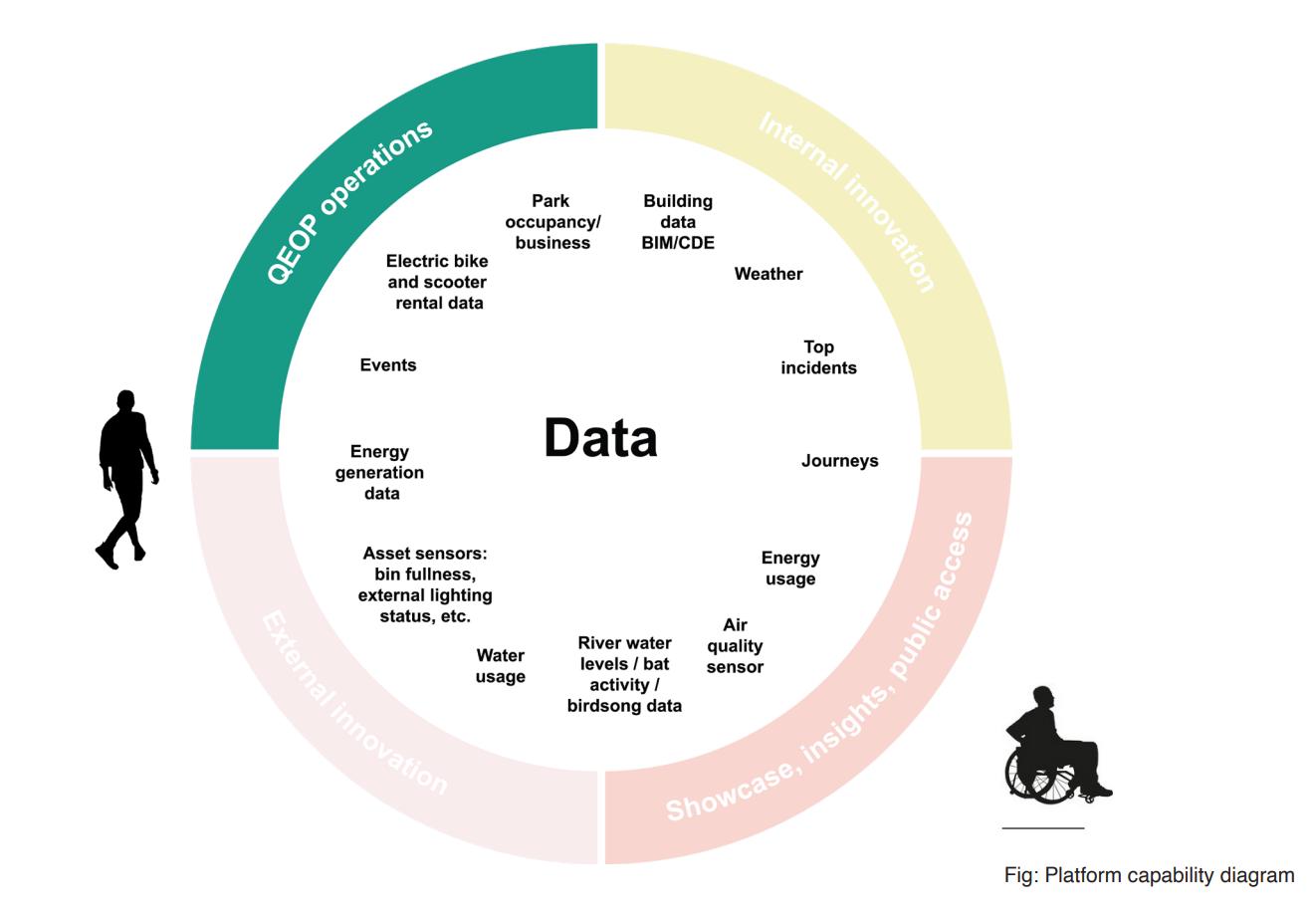
The Digital Frontiers project at Queen Elizabeth Olympic Park (QEOP) is pioneering a new approach to urban spaces, where the physical and digital realms converge.
Professor Andrew Hudson-Smith & Professor
Duncan Wilson


The Digital Frontiers project is an innovative data ecosystem aiming to transform how we understand, manage and design urban landscapes.
Run jointly with SHIFT (a catalyst for east London’s innovators, bringing together business, academia, government and local communities) and University College London’s Connected Environments Lab, the project aims to offer new and emerging opportunities through access to and understanding of data relating to the physical landscape. Real-time data streams from across Queen Elizabeth Olympic Park are being made openly accessible to provide insights into the hidden life of the park that were previously unattainable. For example, urban heat island effects can be mapped in detail, allowing for targeted interventions in landscape design.
Biodiversity monitoring, from butterflies through to the real-time tracking of bats from audio sensors enables a deeper understanding of how landscape elements impact local ecosystems. Park usage patterns, captured through Wi-Fi and mobile data, inform more responsive design decisions and water usage. Data from buildings and waterways supports more sustainable water management strategies in landscape design. Above all, the system opens up data to all stakeholders, to share, view and analyse data from the park.
The technological backbone of this system is based around both Internet of Things (IoT) sensors and Long Range Wide Area Networks (LoRaWAN), creating a mesh of data collection points throughout the park. This data and network feed is being utilised to create a bottom-up digital twin of the park to support collaboration and virtual
experimentation with landscape modifications before physical implementation. Not only does this enable visual insight into proposed landscape interventions, but via simulation techniques, also the ongoing impacts of both design and policy choices.
These emerging technologies are aimed at enabling landscape architects and urban planners to move beyond static, point-in-time analyses to dynamic, responsive approaches. The integration of diverse data streams – from air quality to energy usage – provides a holistic view of the urban ecosystem, informing more comprehensive and sustainable design strategies.
The implications of this approach extend far beyond QEOP. The open-source model for real-time data has the potential to scale to city-wide or even national implementation, transforming evidence-based policymaking for urban environments. Landscape architects could play a crucial role in interpreting and applying this wealth of data to create more resilient, sustainable and userfriendly urban spaces.
Andrew Hudson-Smith is Professor of Digital Urban Systems and Duncan Wilson is Professor of Connected Environments at The Bartlett Centre for Advanced Spatial Analysis. See the full report at shiftlondon. co.uk/shift-announces-digital-frontiers-roadmap/
LI Digital Practice Group member Thomas Yunqing Bai CMLI charts the what, why and how of information management in landscape practice.

3.
Thomas Yunqing Bai CMLI

Landscape architecture is often seen as a profession focused on the beauty of plants, nature and outdoor spaces, with designs traditionally communicated through drawings, images and photographs. However, there’s much more to the field than meets the eye. Behind the delivery of every garden, park or public space lies a complex system of information management. Handling this information is crucial not only for ensuring the successful completion of projects, but also for meeting industry standards and fulfilling contractual obligations. In the past, landscape architects managed this information mostly on paper. Contracts, drawings and project details were stored in large filing rooms and communication often relied on physical documents, with some firms still using fax machines until relatively recently. While these methods worked for a time, they had many drawbacks. Finding specific information was often difficult and revising or updating designs could be a slow, manual process, but as digital technology advanced, the landscape architecture industry began to shift towards more efficient ways of managing information.
Our practice, Ares Landscape Architects, is a good example of this transformation. Like many other practices, we initially relied on manual processes for our design work. We stored documents on paper and while we created 3D models, they were mainly for visual presentations rather than being part of a larger information system. This approach was common across the industry, where information management was often inefficient.
In 2016, we took a significant step forward by adopting Vectorworks, a drafting software compatible with Building Information Modelling (BIM). Integrating BIM into our workflow allowed us to manage information in a more organised way, aligning with new industry standards. By 2018, we had fully embraced BIM Level 2 compliance, which was later replaced by the UK BIM Framework, incorporating both 2D and 3D
modelling along with alphanumeric data. This shift wasn’t just about using new software; it fundamentally changed how we approached design, documentation and working with others.
Transitioning from traditional methods to a BIM-based process came with its challenges. One of the biggest was resistance to change. Moving away from familiar ways of working required a shift in working culture. Employees needed training not only on the new software but also on new ways of managing and thinking about information. Another challenge was the sheer amount of data that needed to be included in the BIM models. Beyond the 3D geometric data, requirements also include alphanumeric information such as facility, object and specificationrelated asset data. Ensuring that this


data was accurate, up-to-date and accessible required the development of new workflows and the adoption of data management practices.
The landscape industry also faced the challenge of adapting BIM – originally designed for building and architecture– to the specific needs of landscape projects. Many existing BIM standards didn’t directly apply to landscape work, leading to gaps between the available tools and what landscape architects actually needed. This often meant that landscape architects had to find creative workarounds to make BIM work for their projects. On one hand, the standardisation required by BIM extensively streamlined the design and delivery process of projects. On the other hand, it also restricted the flexibility and creativeness of the information output.
New digitised practice also brought new risks, such as the possibility of data corruption, ownership of changes, cybersecurity threats and the loss of important information by technical failure. While digital systems made it easier to store and share information, they also increased the chances of hoarding unnecessary information, mistakes and security breaches. This required firms to implement new protocols to treat and protect their data.

Despite these challenges, the benefits of adopting BIM and digital information management have been substantial. One of the most important advantages has been the improvement in the accuracy and quality of project delivery. By bringing all relevant information together into a single model or from a single source, landscape architects can produce more accurate designs, reducing the likelihood of errors and ensuring that the final product meets the client’s expectations. Adopting BIM can be driven by the need to comply with public sector project requirements. Our work in the education sector for the UK’s Department for Education (DfE) required us to follow strict
BIM standards. The standardised processes enabled by BIM allowed us to efficiently manage multiple school projects, ensuring that each one met DfE’s design requirements within tight deadlines. The implementation of Common Data Environments (CDEs) has also made it easier for the design team, DfE and contractors to find information and track the progress of each project, providing greater transparency and accountability. However, BIM has also led us to more efficient workflows as a practice. The adoption of hybrid drafting and compliance with BIM information management standards, including the use of CDEs, has streamlined the design and documentation process for Ares. This has made it easier
7. Utilising geometrical data for detailed design and construction. © Ares Landscape Architects
for the team to collaborate, share information and ensure that everyone is working from the latest and same set of information. It dramatically enhances efficiency and makes project information easily accessible. Moreover, the ability to ‘pre-build’ projects in a digital environment has been revolutionary. Creating detailed 3D models allows landscape architects to spot potential issues and clashes with other consultants before construction begins. This proactive approach helps reduce costly mistakes, saves time and ultimately enables us to make better decisions.
Looking ahead, the landscape architecture industry is likely to further embrace BIM and other emerging
The landscape industry must remain vigilant to the potential risks associated with digital practice and information management. Cybersecurity will be an ongoing and increasing concern, not only in terms of protecting data from external threats but also in ensuring that information is properly managed and protected within the practice.
technologies to improve information management and project outcomes.
While BIM has already had a significant impact, there is still much potential to be unlocked, especially in landscape architecture, where its use is still


relatively new. The data assets in the model could offer benefits not only for construction, such as quantity take-off and costing, but also for laying the groundwork for future facility maintenance and management by the end users.
One promising area for future development is the integration of artificial intelligence (AI) and machine learning (ML) into BIM workflows. These technologies could help automate daunting tasks like data entry and checking, freeing up time for landscape architects to focus on more creative and strategic design work. Additionally, data-driven processes by AI and ML could be used to generate multiple design options based on set criteria, allowing professionals to explore a wider range of possibilities and find the best solutions for each project.
Sustainability and carbon calculation are also likely to be key areas of focus for the future of BIM in landscape architecture. As the industry continues to prioritise environmentally friendly practices, BIM can play a crucial role in modelling the environmental impact of different design options by utilising integrated data and optimising resource use during construction.
As BIM and related technologies continue to evolve, all practices will need to keep up with the latest developments to ensure their processes remain in line with best practice. This will involve ongoing training and a commitment to continuous improvement.
The landscape industry must

remain vigilant to the potential risks associated with digital practice and information management. Cybersecurity will be an ongoing and increasing concern, not only in terms of protecting data from external threats but also in ensuring that information is properly managed and protected within the practice. As digital tools such as
AI become more integrated into the design process, the industry will need to develop new protocols to safeguard against copyright, data loss, bias and corruption, ensuring that information remains fair, accurate and secure.
As the industry continues to evolve, by embracing new technologies and prioritising
sustainability, the role of BIM will become more central to the practice of landscape architecture. However, it is crucial that the industry remains adaptable and continues to rethink how these tools can be used not just to meet client requirements but also to genuinely improve the design process and project outcomes.
Something I learnt at the LI’s Digital Practice & Technology for Landscape conference was, ‘It’s not about how the tech works, but how it works for us’. With a focus on collaboration, innovation and security, the future of landscape architecture in the digital age looks bright and promising.

Tamae Isomura chaired a discussion on BIM for landscape at the Digital Practice & Technology for Landscape conference. Here she reflects on the key takeaways.
Tamae Isomura CMLI

Landscape design encompasses both natural and built environments, making the task of landscape BIM modelling particularly challenging. But there are plenty of opportunities: integrating environmental analysis tools into planting design processes; streamlining manual workflows through digital automation; managing data and information; maintaining quality assurance – the list goes on.
Surrounding all of these benefits, argued Alejandro Masferrer Gatica, Principal BIM Manager and Abhinav Chaurasia, BIM Coordinator and 3D Visualization Specialist at Gillespies, is the ability of BIM to foster collaborative work and interdisciplinary coordination, bringing stakeholder alignment on complex project challenges.
Nehama Shechter-Baraban, landscape architect and BIM expert at Arch-Intelligence, put forward four golden rules to consider when using BIM for landscape.
– Start with existing site: Utilise BIM 3D modelling capabilities to understand site constraints, such as existing buildings, roads, work limits and areas designated for preservation. BIM can significantly enhance the understanding of the site in three dimensions before the design process begins.
– Transition to 3D models: Transitioning from 2D layouts to 3D models allows for enhanced design decisions. By leveraging the BIM model, designers can gather crucial information that informs and improves their design decisions. It is essential to understand the basic layout before diving into detailed modelling.
– Adopt a surface hierarchy: A landscape model is akin to a quilt, where every element, whether it be a path, plaza or slope, is carefully placed and integrated into the overall design. Rather than viewing the landscape area as one single, continuous surface, it should be approached as a collection of distinct parts. The hierarchy in modelling should follow this order:
1. Constraints: Identify and define the boundaries and limitations of the design.
2. Primary Surfaces: These are the main elements of the landscape, such as large open areas or key features.
3. Secondary Surfaces: These include smaller, detailed elements that complement the primary surfaces.
– Use a larger reference surface: Control the grading and overall topography of the site by using a larger reference surface, ensuring that all elements are properly aligned and integrated.

McGregor Coxall’s data-driven design philosophy seeks to transcend disciplinary silos in the built environment to address the complex interdependencies inherent in urban systems.
Michael Cowdy FLI and Jorge Sainz de Aja Curbelo


Planet Earth is a vast, intricate web of interconnected systems that sustain life. For millennia, humanity coexisted with these natural systems, our impact barely a whisper in the grand symphony of nature. However, industrialisation and urbanisation have dramatically altered our landscapes, introducing complex socioeconomic and environmental challenges that reverberate across cities worldwide.
With over half of the global population now residing in urban areas, cities have become the primary habitat for humanity. This rapid urbanisation has led to a host of challenges – pollution, habitat destruction, climate change and a rise in health issues ranging from respiratory ailments to mental health disorders. These challenges not only threaten urban populations’ well-being but also strain healthcare systems, energy resources and the resilience of both urban and natural environments.
Yet there is a growing realisation that cities and nature are not separate entities. A powerful shift in perspective is underway– one that seeks to restore and redefine the relationship between urban spaces and the ecosystems that sustain them. This vision emphasises the essential ecological services that underpin urban life, from air and water purification to climate regulation and mental health benefits.
Digital technologies are pivotal in helping us to realise this vision. Tools such as artificial intelligence, digital twins and data-driven design provide new insights that empower landscape practitioners to craft more resilient urban ecosystems. These technologies enhance decision-making, ensure design consistency and enable more efficient urban spaces. By harnessing these digital tools, we can develop integrated solutions to the urgent challenges of climate change, biodiversity loss and public health, ensuring that our cities not only survive but thrive in harmony with nature.
The Biourbanism Lab, McGregor Coxall’s research and development arm, drives this vision forward through innovative research and data analytics. The lab’s approach transforms data into actionable insights that directly inform design decisions. By linking research and design through data and using custom key performance indicators (KPIs), the Biourbanism Lab bridges the gap between vision and implementation.
This data-driven design philosophy is embodied in McGregor Coxall’s Living Infrastructure Framework, a holistic approach that integrates natural systems within built environments. The framework is organised around four key areas: social health and wellbeing, climate adaptation and resilience, sustainable and green economy, and smart governance and delivery. Each area is supported by sublayers with custom KPIs, allowing the lab to evaluate and optimise design performance.
What sets this framework apart is its ability to transcend traditional silos within the Architecture, Engineering and Construction (AEC) industry. By cross-referencing data from diverse thematic areas, the Biourbanism Lab addresses the complex interdependencies inherent in urban systems. For instance, by examining the interplay between economic and ecological criteria, the lab uncovers insights into ‘Ecologic-Economics’ – exploring how economic activities and ecological health are intertwined in urban environments.

1. Living Infrastructure Framework. Image showing different key areas and sub-themes evaluated through the framework. McGregor Coxall, 2024

2. Digital Approach. Set of steps to establish interrelationships between disparate datasets towards design task support. McGregor

Figure 3. Analytical and Categorical models generated by the Living Infrastructure Framework implementation. Note that analytical models generate a full 3D model thanks to LIDAR point cloud data. McGregor Coxall, 2024
Central to this process is translating multidisciplinary inputs into a common language: data. This approach empowers stakeholders from various backgrounds to collaborate effectively, linking non-design disciplines to design tasks through a parametric approach. By moving away from isolated, discipline-specific practices, the Living Infrastructure Framework fosters a highly complex and interconnected system that informs every stage of the design process.
The practical application of this process begins with data gathering, facilitated by the Living Infrastructure platform – an innovative in-house tool developed by the Biourbanism Lab. This platform aggregates data from various official and open-source datasets, including Ordnance Survey, Landsat 9 and DEFRA among others, integrating them into a unified model. However, the platform’s capabilities extend beyond data collection. It implements a sophisticated knowledge graph that establishes interconnections between data points based on the Living Infrastructure Framework. Each data point is categorised and weighted according to McGregor Coxall’s extensive project experience, ensuring the data reflects the nuanced realities of social, cultural and environmental contexts.
This curated data is then utilised in two models available to designers: a 3D analytical model that visualises the results of all analyses and a 2D categorical model that organises data according to the Living Infrastructure categories and subcategories. These models
enable designers to make informed decisions and establish a solid foundation for project development.
One of the most effective methodologies employed by McGregor Coxall is the Multiple Objective Evolutive Algorithm (MOEA). This advanced algorithmic approach optimises design scenarios based on project goals, stakeholder input and Living Infrastructure KPIs. By clearly defining project objectives and their relative importance, the MOEA generates design options that align with broader goals.
This holistic approach ensures that every design scenario is rooted in a deep understanding of the complex interrelationships within urban ecosystems. By leveraging the power of data and digital technologies, McGregor Coxall is charting a new path forward –one where cities and nature coexist in harmony and where urban development contributes to a healthier, more sustainable future for all.
Michael Cowdy is the UK Founder and Director of McGregor Coxall and a Fellow of the Landscape Institute.
Jorge Sainz de Aja Curbelo is the UK Biourbanism Lead at McGregor Coxall and holds a PhD in data-driven urban regeneration strategies.

With the implementation of Biodiversity Net Gain (BNG) comes a significant opportunity for more data-driven approaches to design, as well as more collaboration on projects. Here, three perspectives on key technologies provide insight into how.
From Geographic Information Systems (GIS), to computer aided design (CAD), to Building Information Modelling (BIM) and beyond, digital technologies are becoming essential tools for landscape professionals to provide integrated services that help to boost biodiversity on projects and help nature recover.
In this series of perspectives from across the landscape sector we look at these technologies, as well as where
they overlap and interact, finding out how they can be incorporated into workflows and bring disciplines together collaboratively on projects.
The mapping capabilities of GIS enable the spatialisation of data, which forms the basis of any biodiversity or ecological assessment of a given project. Combined with the design functionality of CAD, this data can be incorporated into landscape designs which ensure the right planting is used in the right place to make best use of
the land, alongside other competing objectives and outcomes. By using BIM, designs can be visualised as 3D models that can track live data over time, which is fed back to practitioners to model design iterations and inform project maintenance. The possibilities are growing all the time.
With BNG providing the stimulus for more data-driven approaches to decision making, as well as more collaboration between disciplines on projects, how can technology help?

Over the years landscape architects and ecologists have been like wo tribes – one using computer aided design (CAD) to design, the other using Geographic Information Systems (GIS) for site management and spatial analysis. But with Biodiversity Net Gain (BNG), there is a real need to collaborate.
While an ecological survey will establish the current biodiversity baseline on a site, it will often be a landscape architect’s design that will define the biodiversity value post-development. A 2022 Landscape Institute policy briefing¹ suggested that, for landscape architects, BNG would mean liaising closely with project ecologists from inception, translating their recommendations into plans and designing sensitively to retain and enhance key existing habitats. It also recognised that the ‘accurate translation of habitat boundaries between GIS and CAD is vital to avoid frustration and delays’.
I’m not a CAD user, or a practising ecologist, or a landscape architect. I’m a GIS specialist and I love to collaborate, working daily alongside both ecologists and landscape architects. I wanted to better understand the issues both groups experience around GIS, CAD and BNG, so I reached out and spoke to both groups.
A number of factors contribute to the issues involved in integrating data from CAD to GIS, from there being so many CAD systems, each with their own proprietary functionality, to poor drafting
and layer management in CAD, which result in errors imported into GIS software, to the sheer number of disciplines that may have worked on a CAD file before it arrives with the ecologist. Here’s how to improve the workflow for better collaboration:
– Be aware that the main map projection used in the UK for BNG assessments is EPSG 27700: British National Grid, and ensure coordinates are set to metres before providing data to an ecologist.
– Remove page elements, including legends, unrequired layers and design revisions.
– Ensure good drawing practice and layer management to ensure data integrity.
– Discuss your needs with landscape architects and ask for unnecessary layers to be turned off.
– Be specific about the projection needed, setting coordinates to meters and that habitat area calculations require continuous polylines and closed polygons.
– Request data to be saved as ASCII format DXF, which will make it easier to import and work in GIS systems.
– Discuss UK habitat classifications, plant codes and pallets with the landscape architect to aid understanding and interpretation.
Matthew Davies is a GIS specialist and founder of Maplango.

QGIS BNG Assessment Project with CAD data loaded to the Proposed Habitat layer. Background map © OpenStreetMap
¹
2. Performing a


Urban Green utilises Geographic Information Systems (GIS) for data collection, data analysis and presentation, as a valuable tool to inform all aspects of site assessment across in-house teams including landscape, ecology and urban design.
Often, the initial baseline assessment consists of an ecological and biodiversity survey, undertaken in accordance with the UK Habitat Classification System (UKHAB). The ecology and Biodiversity Net Gain (BNG) teams use an on-site GIS data collection survey system that is specifically tailored for UKHAB surveys and BNG metrics. Species lists and condition scores are then recorded within the system, accurately positioning and associating to their mapped habitats to inform the Biodiversity Metric¹ baseline data.
Once the on-site data has been collected it will be transferred through to GIS software. The data will then be processed and mapped on to the site’s topographical survey to map habitat data and tree surveys live in the field, supporting assessments and feeding into the landscape proposals.
Through close collaboration between the Landscape Design and BNG teams, the proposals are tested and refined to maximise the on-site opportunities available and explore ways to incorporate new or enhanced habitat types and landscape features.
¹ https://www.gov.uk/ guidance/biodiversitymetric-calculatethe-biodiversity-netgain-of-a-project-ordevelopment
² https://publications. naturalengland.org.uk/ publication/ 5846537451339776
This design information is produced in CAD to enable the habitat areas, linear features, blue infrastructure and other components to be measurable and quantifiable. These quantities are then transferred into the BNG metric calculator to show
both the pre- and post- development elements of the site and if the required minimum 10% net gain has been achieved.
The existing and proposed habitat maps will then be translated into an Urban Greening Factor² map which simplifies the UKHAB classifications. This simplified version can aid the end design of the projects, allowing for the best biodiversity net gain results.
BNG is still evolving. Local authorities and developers are still new to the processes and requirements and no two projects are the same, so a flexible approach is required.
The use of GIS technologies in particular aides this flexibility, furthering interdisciplinary collaboration through an efficient, accurate and comprehensible way of producing a BNG assessment. This is a key asset in the production of holistic, environmentally conscious schemes which are beneficial to both the local wildlife and the communities they serve.

Tim Calnan CMLI

The University of Birmingham Molecular Sciences Building, completed in 2023, is an £80 million project including a landscape designed and delivered using Building Information Modelling (BIM).
The university gardens’ planting scheme was created using BIM to design single planting, area planting and the creation of planting mixes. Rather than having to manually define planting types, specification information and quantities, the project team was able to use a centralised, cloud-based platform to create and manage plants and mixes collaboratively throughout the design phases.
Importing directly from cloud-based planting libraries, the design team created palettes of single species and mixes that best reflected the specific requirements of the project, which incorporated shade, semi-shade, sun, slopes, buffers and retaining walls. The planting in the model was automatically populated with characteristics such as
height, form, spread, growth rate and ultimate height at maturity of each specimen. With any changes to the model immediately displayed in plan, section, elevation and schedule views, the team was able to test and evaluate their choices in real time as the design progressed.
Being able to view planting components in a 3D model enabled the team to consider the impact of trees above and beneath the ground, whether as a result of their canopies, growth, ultimate height and spread, shadow casting, tree pits and root balls. Used alongside other technologies, more opportunities open up, as design options can be used in conjunction with virtual or augmented reality technologies to provide users with an immersive 4D experience of the designs.
Models such as this can also be used in Biodiversity Net Gain (BNG) assessments, helping practitioners to map out different potential habitat scenarios and measure design iterations against the anticipated net gain throughout the design process. Combined with Geographic Information System (GIS) data, practitioners can model project change over time and once built, the model can even become a digital twin, modelling live, real-time data and informing ongoing management and maintenance.
From plant selection to real-time iteration, tools for design automation, review, modification and visualisation are becoming essential for better collaboration, coordination and efficiency.
Tim Calnan CMLI is founder of Cloudscapes.
Landscape and Carbon Steering Group member
Sam Bailey CMLI takes a broad definition of technology to look at how new innovation can help to reduce carbon in landscape projects.


Sam Bailey CMLI

‘Technology: the application of scientific knowledge for practical purposes, especially in industry.’1 Taking this broad definition of technology, which could span the digital, mechanical, material or biological and harnessing it to take a perspective from today, one might expect that the rapid advancement of technology this millennium and the explosion of knowledge spawned by the internet, would have spurred a great amount of progress for its use in sustainable development. However, construction can be a slow beast to adapt and the landscape sector remains engrained in traditional construction methods used for many decades. In contrast, buildings and all the elements they are made of, have benefited from technological advancements, including Modern Methods of Construction (MMC) and advances in renewable technology which are making them cleaner and more efficient.
The slow uptake of technological improvements in our industry may be attributed to the inherent perception that landscapes are simply nice, green and environmentally friendly. However, the hidden carbon costs of these projects often go unnoticed. The carbon impact of landscape development is a fraction of building and structural elements, but the carbon reductions that can be made, with relative ease, are significant. Understanding that impact is key and easily comparable knowledge will help bring that into decision-making.
The consideration of carbon in projects presents an important dilemma: How do we balance the creation of biodiverse landscapes, active travel and neighbourhood regeneration while ensuring that the materials and methods we employ to create them do not impose an unsustainable environmental
cost? Development is inevitable, so minimising emissions is crucial. Achieving this goal starts with a thorough understanding of the impact our choices have. While awareness of global warming is widespread within the industry, the intricacies of material choices and their carbon costs, along with the data on carbon sequestration through planting, are less understood.
This is no fault of landscape designers and builders – there is simply not enough data for meaningful analysis. The available data is often scattered and inconsistent, making it difficult to make accurate comparisons. However, this should not deter us from making informed decisions based on the information we do have. Current and future technology can aid in both the acquisition of detailed data and better decision-making, but these advancements must work in tandem to facilitate rapid emissions reductions.
Data availability and carbon calculation methods
First, let’s look at the current data landscape. If you are in the world of specifying and using materials in landscapes, some tools are imperative.
Tools like Building Environment Carbon Database (BECD),2 Embodied Carbon in Construction Calculator (EC3)3 and the Inventory of Carbon & Energy (ICE)4 are essentially data hubs where suppliers can submit their Environmental Product Declarations (EPDs). EC3 is also a tool to calculate embodied carbon based on quantities input from models or manually.
EPDs are provided by suppliers to these databases (and others), but often there is little information relating to landscape products. The most common appears to be paving units, but there are few to no EPDs from plant or tree suppliers.
Lifecycle analysis is the process of analysing the long-term environmental impacts of a product or project and this is usually undertaken by specialist sustainability consultants.
OneClickLCA5 is an example of an external LCA provider which has proprietary tools to calculate environmental impact, but of course this comes at a financial cost to the project.
Analysing the available data is equally as tricky as finding it, but fortunately tools such as Pathfinder 6 by Climate Positive Design (see Landscape Autumn 2023, p49–51 for a review) distil this into more digestible figures, allowing users to create custom materials to upload data that is not found within the system. The Pathfinder tool doesn’t currently link to the above databases but there is a plan to link to EC3 in a new release in the coming months.7 The Carbon Conscious App by Sasaki8 will also link together with Pathfinder, allowing for a more seamless connection between its own figures for large-scale land carbon analysis and the more detailed specifics attributed to Pathfinder. Both tools are currently the most intuitive on the market, free to use and can help ensure better decision-making. Their current issue is the lack of UKfocused data, but by linking into more global databases this will hopefully be improved over time.
1. (Previous page) Technology for climate action, an overview illustration.
© Darkhorse Design
2. Reducing Carbon in Landscape projects, an overview illustration.
© Darkhorse Design

1 https://www. oxfordreference.com/ page/134
2 https://www.becd. co.uk/
3 https://www. buildingtransparency. org/
4 https:// circularecology.com/ embodied-carbonfootprint-database.html
5 https://oneclicklca. com/en-gb
6 https://app. climatepositivedesign. com/
7 https://issuu.com/ bslafieldbook/docs/ fieldbook_climate)
8 https://carbonconscience.web.app/


Manual calculation is another method of carbon analysis. This can be undertaken using spreadsheets, or schedules linking to Building Information Modelling (BIM). I have previously experimented with this successfully, managing to extract volume and quantity data from Revit models, then creating custom ‘Embodied Carbon’ fields using EPD data, or assumed averages where the data is not known. The schedule then creates totals which can be used to understand the environmental impact of the project better. Vectorworks Landmark has an inbuilt version of this called Vectorworks Embodied Carbon Calculator (VECC).
Unfortunately, there remains little data around the carbon sequestration value of trees and planting. The work required here demands future research and is out of my own area of expertise. Suffice to say it is not definitive, as the growth pattern of trees and planting varies so much on location, climate and soil volume and conditions, but every effort should be made to understand this more.
The Landscape Institute’s Landscape and Carbon Steering Group is currently reviewing the best approaches to calculating landscape project carbon, including embodied carbon and sequestered carbon and will be providing guidance for the industry on this in due course.
Strategies for immediate emissions reductions
Making informed choices to reduce emissions involves a broad understanding of existing materials and alternative construction methods, along with a good knowledge of the material impact.
Alongside the analysis of proposed designs, using BIM models or manual drawing take-offs to calculate existing on-site materials can inform the potential reuse of materials. For example, the reuse of existing bricks within gabion baskets, or existing paving materials repurposed into new patterns and areas, can provide huge carbon savings instead of extracting, producing and transporting materials to site. Similarly, measures of existing concrete can be taken and analysed with a view to crushing and reusing the material in subbases or similar. This way of working has been highlighted in the work of architect Duncan Baker Brown and explored in practice in the influential Pheonix project by Periscope and Human Nature.
Use of drone surveys for complex 3D scans, or even the Polycam app,9 can enable you to survey existing
furniture, fencing, boulders, walls and topography to analyse what is on site. Incorporating these into your own model and designs has the potential to make immediate carbon savings. Practical risk concerns are understandable as we don’t want to see catastrophic material failure, but the risks associated with reusing materials in landscape projects are much lower than other industries and will hopefully enable the industry to create a culture change, bringing clients and contractors on board.
Gone are the days when every site element should be ‘off the shelf’; designers should now be looking to adapt and reuse.
This principle is key to improving the circular economy and platforms such as Building Material Exchange10 provide a central digital location for trading excess, recycled or repurposed building materials. European counterparts are also exploring this, as illustrated by Superuse, which created an innovative playground from disused wind turbine propellers.11
Soil reuse is a huge one to understand, as any disturbance of existing soil will have knock-on carbon implications and the carbon emissions for the import and transportation of new soil can be significant, potentially outweighing the carbon benefits of


3. Manual calculation for carbon analysis illustration.
© Darkhorse Design
4. Circular economy illustration.
© Darkhorse Design
The Landscape Institute’s Landscape and Carbon Steering Group is currently reviewing the best approaches to calculating landscape project carbon
9 https://poly.cam/
10 https://www. buildingmaterial exchange.com/
11 https://www. superuse-studios.com/ projectplus/blade-made
12 https://www.rhs.org. uk/education-learning/ pdf/bursaries/bursaryreports/rhs-bursaryreport-sally-bower.pdf
13 https://www. materialepyramiden.dk/
planting a few trees in the area. Experimental techniques in growing mediums have long been explored by the University of Sheffield,12 for example using aggregates, recycled bricks and other waste materials for creating droughttolerant, free-draining planting areas, as evidenced by the Grey to Green scheme in Sheffield. It comes back to the reuse: what is on site that can be successfully mined and incorporated, in turn bringing carbon savings by not extracting, processing and developing more materials.
When specifying new products and materials, consideration should be given to the impact those materials have. A useful resource for a broad understanding is the Material Triangle,13 which makes it easy to quickly compare the carbon footprints of different materials. At the top are key culprits aluminium, galvanised steel and glass. It’s easy to say that we should avoid using these materials, but the question of what can replace them
should also be raised. If we replace aluminium with steel, to what extent will it decrease the longevity of the product? If we specify weathered steel instead of galvanised, how long will it last? Is it better to specify galvanised if it were to last twice as long? Is it better to install timber fencing with the knowledge that it may only last 20 years before replacement, or would it be better to accept the carbon cost of something more robust that lasts longer? Time is an important consideration when dealing with carbon and will often be a nuanced one, depending on the situation and maintenance requirements. I don’t know the answer to these questions, but they show the importance of standardised EPDs, provided by suppliers across sectors, to allow us to make informed decisions.
AI could help us analyse EPDs and complex data much quicker, allowing us to draw conclusions which influence project decisions; however, this technology is still in its infancy and can
often misinterpret data it hasn’t been fully trained on. Advancements will improve this and AI is likely to be a key factor in improving our understanding, if only through its processing speed in the near future.
Embracing technology in landscape architecture offers immense potential for reducing carbon emissions and creating more sustainable environments. By understanding and improving on the these technologies (digital and non-digital) and adopting pioneering practices already being explored experimentally, there are huge carbon savings that can be achieved with relative ease, creating a positive lasting impact for the climate.
Sam Bailey CMLI is an independent chartered landscape architect working with a range of practices across the UK and a member of The Landscape Institute Landscape and Carbon Steering Group.


With the rising awareness of climate change and its effects, industries across the globe are increasingly recognising the importance of reducing their carbon footprints.
Among these, the landscape and urban design sectors play a pivotal role in shaping the environmental impact of the built environment. One of the significant aspects of this impact is embodied carbon – the carbon dioxide (CO₂) emissions associated with the production, supply and lifecycle of materials used in construction for landscape projects. This article looks at the importance of calculating embodied carbon and the role of the Vectorworks Embodied Carbon Calculator (VECC) in aiding landscape architects and urban designers in doing this.
Embodied carbon refers to the total CO₂ emissions produced throughout the lifecycle of a material or product, from production and transportation to installation and disposal. While architects often focus on reducing embodied carbon in buildings and materials, landscape architects strive to balance embodied carbon with

sequestered carbon in their designs or even create carbon-negative landscapes. This consideration spans everything from the concrete in footings to the light fixtures in garden beds. Accurately calculating and mitigating embodied carbon is essential for achieving net zero carbon goals in landscape projects. Decisions on material specification, construction methods, even plant suppliers, can greatly affect the total embodied carbon of a project. By applying low-carbon strategies and choosing materials with lower embodied carbon, landscape professionals can make substantial contributions to sustainable design. However, to make informed decisions, they need accurate data on the carbon impacts of various materials, which VECC can fulfil.
VECC includes two pre-formatted worksheets, one for the early stages of a project and another for the advanced stages. These worksheets are built on the traditional phases of a product’s lifecycle, often called the ‘cradle to grave’ cycle:
– Product Stage: Tracks embodied carbon from the supply, transport and manufacturing of selected raw materials.
– Transportation Stage: Monitors carbon emissions transporting products from the manufacturing plant to the project site.
– Construction Stage: Accounts for emissions from any on- or off-site construction activities.
– Replacement Stage: Considers carbon emissions related to the anticipated replacement of
landscape components.
– Deconstruction & Demolition Stage: Tracks emissions arising from demolition activities.
– Recovery & Recycling Stage: Focuses on emissions associated with the treatment and processing of materials intended for reuse after the end of the project’s lifecycle.
These stages allow for a comprehensive calculation of embodied carbon, providing landscape professionals with the information needed to minimise the environmental impact of their designs. Since VECC is integrated into Vectorworks, it automatically identifies the volume of materials applied to 3D objects, such as walls, pavements or concrete footings. The embodied carbon values embedded in Vectorworks materials are then used to calculate the total embodied carbon for the project.
In the early stages of a project, VECC utilises generic material data, allowing for preliminary assessments of embodied carbon. More specific manufacturer data can be integrated as the project progresses, enabling more accurate calculations. This two-stage approach ensures that the transition from early to advanced design stages is as seamless and automated as possible.
The introduction of VECC is a response to the growing need for tools that help reduce carbon emissions in the landscape industry, providing a foundation for this by following existing industry standards and using industry-

specific data. This makes VECC an invaluable tool for cross-disciplinary collaboration, allowing landscape architects to work alongside architects, engineers and other stakeholders to achieve a common goal.
VECC’s flexibility is one of its greatest strengths. Landscape architects can use the tool to create a library of materials tailored to their needs, enabling them to specify products in regard to their Environmental Product Declarations (EPD) data. By integrating EPD data into their calculations, designers can achieve the desired accuracy in determining the total embodied carbon of a project, ultimately leading to more sustainable design choices.

While VECC provides a robust framework for calculating embodied carbon, the landscape industry must also consider carbon sequestration. This means that future tools will need to incorporate data on soil carbon and vegetation to provide a complete picture of a landscape project’s carbon impact.
Calculating embodied carbon in landscapes is a critical aspect of sustainable design. VECC offers landscape architects and urban designers a powerful tool for assessing and reducing the carbon footprint of projects at the design development stage. By embracing tools like the VECC and considering the entire lifecycle of materials, the landscape industry can play a vital role in the global effort to combat climate change.
Visit vectorworks.net to learn more about integrating VECC into your workflow and stay tuned for a webinar on ‘Embodied Carbon Calculation in Landscapes’ at campus.landscapeinstitute.org.
Marketa Hermova is Landscape Product Specialist at Vectorworks.

Co-founder of the Digital Task Force For Planning and former independent trustee of the Landscape Institute, Dr Wei Yang, argues for a transformation of planning methods for a digital era.
Dr Wei Yang

I believe the fundamental objective of the built and natural environment profession is to create a balanced system where people, nature and society coexist in harmony. An interconnected, holistic ecosystem.
In practice, balancing housing, infrastructure and resource needs with the protection of natural capital and climate resilience requires multifunctional land use. This is where spatial planning can play a vital strategic role in developing a long-term vision and framework for communities by considering multiple scales, balancing competing demands and guiding land use and resource allocation decisions.
Spatial planning practice extends beyond the legislative planning system. As an applied social, environmental and behavioural science, its scope encompasses cities, rural areas and marine environments. By adopting
a place-based systems approach, spatial planning unites expertise from both built and natural environments. This integration is crucial, as no single discipline can tackle today’s complex challenges alone. Digital technologies and scientific innovations present significant opportunities for spatial planning. The landscape sector plays a pivotal role in shaping sustainable, resilient environments and so engagement is key.
Looking ahead, it is essential to reimagine spatial planning in the digital era – not simply digitising the current system, but transforming planning methods to fully harness new technologies. A digitally enabled spatial planning methodology could help us to integrate nature more effectively into living environments, enhance communication among stakeholders and ensure planning decisions reflect community needs. Engaging communities through digital platforms and traditional methods leads to outcomes that harmonise development with environmental preservation. Advanced modelling and simulation tools facilitate further scenario testing and outcome prediction, supporting land optimisation strategies that balance urban growth with biodiversity
conservation and agricultural productivity. Furthermore, realtime monitoring enables ongoing assessment strategies, ensuring that strategic nature-based solutions remain central to planning decisions.
The Digital Task Force for Planning is a not-for-profit social enterprise co-founded by Professor Michael Batty of University College London and me in October 2022. It was formed to implement several urgent actions identified in our report, A Digital Future for Planning: Spatial Planning Reimagined.1 In the report, we outlined a collective vision for the future of planning, positioning spatial planning at the forefront of addressing grand challenges and envisioning a planning profession equipped with new digital tools, expertise and improved data. More recently we have established strong partnerships with key stakeholders. In 2024, we signed two landmark memorandums of understanding with the Ministry of Housing, Communities and Local Government (MHCLG) and Ordnance Survey (OS) to advance our collaborative efforts in digital planning.


The Digital Planning Directory
The first project to be delivered under our partnership with MHCLG is the development of a Digital Planning Directory – a comprehensive and user-friendly online resource for listing digital planning service providers, tailored to meet the diverse needs of stakeholders in both the public and private sectors. Seed-funded by MHCLG, the Directory will include a range of UK digital planning service
providers, including: community engagement; visualisation, 3D modelling and animations; GeographicalInformation Systems (GIS) and mapping; environmental and sustainability services; planning and urban design services; land search and assessment; plan-making, planning application and data management systems; artificial intelligence (AI) and software solutions; organisational digital transformation and digital twins.
We welcome organisations and practitioners from across the landscape sector with state-of-the-art digital solutions to join the Directory.
The Directory will open for entries from digital service providers at the end of September 2024, with a launch expected in mid-January 2025.
Our goal is to unlock the full potential of spatial planning in the digital era by acting as a convenor, facilitator and enabler of digitalisation in spatial planning practice and education. We aim to reinvigorate the profession by integrating advanced digital tools and cross-disciplinary knowledge. By addressing digital skill gaps, promoting open-source research and fostering collaboration, we strive to create an innovative ecosystem that benefits society and the environment, prioritising public good and supporting a sustainable future for everyone.
This is a crucial step in developing the digital planning ecosystem. Following this, we will organise a

series of interdisciplinary programmes to promote best practices and advance digital transformation in mainstream practices and education. The landscape profession plays a vital role in bridging the built and natural environments, making crucial connections that enhance our living environment. The future of built and natural environment practices should be interdisciplinary and digitally empowered and the contribution of landscape professionals will be essential for shaping a digital future that benefits people, nature and society.
Dr Wei Yang is co-founder and CEO of the Digital Task Force for Planning and chair of Wei Yang & Partners.
Scan the QR code to view the report.


We talk with digital placemaking expert and landscape architect, Mark Jackson, to hear how the emerging world of virtual, augmented, mixed and extended realities can influence the profession.
1 https://www. landscapeinstitute. org/news/li-publishessecond-edition-digitalrealities-technicalinformation-note/
Mark Jackson

What are the possibilities offered by XR for landscape professionals?
XR can be utilised at all scales of practice, depending on the resources available. A global firm may already have extensive resources and dedicated teams (who aren’t landscape architects) focusing exclusively on 3D visualisation and XR functionality, so it is more likely that landscape professionals in small to mid-sized companies will pick up and develop hands-on experience with XR. Meanwhile local government is ideally placed to apply XR, with its broad representation and responsibility for community in specific areas. Connections between virtual and physical places will continue to be limited with only computer screens and smartphones as the main operating devices. By working with XR technologies, landscape professionals can begin to include virtual space as a functional aspect of the physical space. There could be possibilities for using XR to enhance landscape management, education or play. There is lots of uncharted territory ahead.
Is XR an asset to the profession or a challenge. Can it be both?
It is a challenge both to the profession and local communities, but there are benefits to be gained.
A key benefit of XR is the ability to create immersive experiences. As part of the design and consultation process, 3D models set expectations from clients and the community. Where plans and photomontages can only be scrutinised as a static image, interactive 3D models provide far more detail and therefore far more opportunity for design resolution and interrogation. The exciting prospect with XR lies in the programming of the space; the intentional blend of physical and digital assets, how they interact and how the content is developed.
Practitioners could be willing to embrace XR through the adaptation of established methods if there is a business case or clear benefit to the community. The obvious challenge of new technology is the initial and ongoing investment and time spent understanding the practicalities of its use, or alternatively the expenditure of outsourcing it.
What recent advancements have we seen in these technologies?
The LI’s Digital Realities Technical Information Note¹ provides a broad spectrum of hardware and software available and referral to this is highly recommended. More recent advancements have been made with
lighter, untethered, more affordable head-mounted displays (HMDs) by Apple, HTC and Meta, creating more tangible use cases. Practitioners can design, document, display, distribute and even meet in virtual settings with these HMDs. While the metaverse has received a lot of attention in recent years, it has to be more specific and organic than Meta’s vision of it. It could be used as a canvas, a digital twin, where people can collaborate on specific projects and this variant of the metaverse would be of value to landscape architects. Meanwhile, rendering packages have improved over the years, giving us the ability to age a design and overlay weather. We’ve progressed
The Landscape Institute (LI)’s Digital Realities
Technical Information Note1 uses ‘digital realities’ as a collective term for augmented reality (AR), virtual reality (VR), mixed reality (MR) and extended reality (XR).
VR Virtual reality (VR) is an interactive experience which takes place in a simulated environment created using audio and visual stimulation, typically through use of a head-mounted display (HMD). The experience can be constrained, for example a 360-degree photo or video where the user is entirely immersed in the content but can only look around, or it can offer freedom of movement, allowing the user to explore the virtual world they are experiencing.

AR Augmented reality (AR) is an interactive experience of a real-world environment, augmented by digital information overlaid in either a constructive manner (i.e. information added to the real-world environment), or in a destructive manner (i.e. used to mask the real-world environment). The digital information is seamlessly interwoven with the real-world environment so that it is perceived as an immersive aspect of that real environment.
MR Mixed reality (MR) is an interactive experience where a real-world environment is merged with a virtual environment, so physical objects and digital objects coexist and interact in real time. MR requires physical spaces to be mapped, using point cloud data, to capture associated dimensions and objects within that space. Digital models are then anchored to the space and, as users move around, physical objects positioned between the model and device camera cause the model to become occluded, as though it was physically in that space.
XR Extended reality (XR) is used to refer to all real and virtual combined environments and human-machine interactions generated by computer technology and wearable technology.


from 2D to 3D to real-time XR and can export film and navigable models.
Landscape architects are familiar with 3D software, but geolocating assets from models with AR is less common. Apple leads in this space, but Android is catching up and Adobe Aero currently has beta software available that operates in conjunction with Google Geospatial locator. This can be used to anchor 3D models, animations and audio on X, Y and Z axes. Elsewhere, Trimble’s Sketchup AR app is useful for anchoring and displaying models in situ with ground detection. With both pieces of software, scale, complexity and file size present the main challenges, so instead of displaying complex models in their entirety, it’s still better to isolate specific assets or portions of 3D models.
How can landscape practitioners integrate these technologies into their design workflows?
Practitioners should look for programs provided as part of their existing subscriptions as a starting point, be aware of the limitations of their hardware and ask what the problem is they are looking to overcome. Be wary of heavily investing and integrating software unfamiliar and untested in the profession and this includes software by developers who do not guarantee ongoing updates and network support. It would be prudent to assign adequate resources into the use and operation of XR. There is no point in purchasing head-mounted displays or paying for software subscriptions if the knowledge of its use only lies with an individual. Championing XR and educating peers on how it can be used is essential.
This neighbourhood park demonstrated the use of AR for community consultation and as part of the final design, with AR used to communicate how the slide would look from any angle in real time. To do this, the 3D model was provided by the manufacturer and then tailored to reduce the file size and enable display in AR (below 50mb). There was some trial and error in the process, not only with the file size, battery power and loading times, but also with the capacity of the smartphone to display it (a Samsung S21 in this instance). However, the persistence paid off and was used to promote the plans. Further use of AR is planned, with geolocated sound recordings of the local historic poetry, accessible via the physical panels throughout the park.
Information exchange between disciplines can also be beneficial. This does not necessarily need to relate to live projects. It can emerge in more organic ways such as a design competition or a jam session with other creatives who have experience with XR, such as those in the games industry.
What is the future of XR and the impact on Landscape architecture and digital placemaking?
There should be a closer relationship between digital placemaking –the digital augmentation of the environment that enhances the experience of place – and landscape architecture. It is an emerging specialism within the profession with a wealth of practical applications and technologies now available. AR can be used as a way of
assigning a cultural narrative to spaces, both retrospectively and as part of new builds. This is especially effective when the community is a key stakeholder in the process, informing design through their knowledge of place and, for certain stakeholders, empowering them to create content for integration with the physical aspects of design. This is the true democratisation of the public realm, but it will also be crucial to filter the commercial intrusions.
The programming of the public realm with XR interactions presents a huge opportunity to empower and rejuvenate, especially where content can be created by the community through a placemaking project. With XR we are only limited by our imagination, but generating contextually relevant content is crucial and it must be continually managed to stay synced, relevant and fresh.
Mark Jackson is a digital placemaker, landscape architect and founder of Place Jam.


The Landscape Character Assessment (LCA) Database includes over 500 LCAs from local to regional scale across the UK and Ireland, offering a single digital resource for landscape character data now and in the future.
1. Supporting the energy transition with Landscape and Visual Impact Assessment site work in the Highlands.
© AECOM
2. The LCA database is referenced on the front page of the NCA Profiles website highlighting the nested nature of landscape character assessments
© Natural England
1 https://royalsociety. org/news-resources/ projects/livinglandscapes/ multifunctional-landuse/
2 https://www. landscapeinstitute.org/ technical-resource/ landscape-characterassessment-lcadatabase/

Charlotte Williams CMLI and Jacqui Jobbins CMLI

Our diverse landscapes provide the context of social and environmental change, not least as society looks to address the climate emergency and biodiversity crisis. As we develop approaches to embracing this change, our landscapes will need the utmost care and consideration to avoid their diversity being lost.
The Royal Society estimates in its Multifunctional Landscapes paper (2023)1 that by 2050 the UK would need additional land twice the size of Wales, or 18% of the total UK land area, to meet the sum of the net zero and biodiversity policy targets. To respond to these demands, there is an urgent need to understand the landscape to facilitate informed decisions and enable positive, resilient landscape change.
While we are not suggesting that all landscapes should be preserved, or that change should be stopped, we need to identify what makes given landscapes special and reflect this in the changes. We also need to consider people and what they value about their local landscapes. Landscape
Character Assessment (LCA) is one of the key tools which supports this understanding.
The LCA Database for the UK and Ireland2 provides a single resource for all professions needing to access landscape character data now and in the future. The resource has links to over 500 landscape character assessments at a variety of scales from regional, county and district, to designated landscapes and local assessments, providing the profession and wider users with considerable data efficiency.
In December 2020, Charlotte Williams CMLI spoke at a Landscape Institute webinar on ‘Understanding the
Value of Spatial Data’, which covered landscape character assessment and the difficulties with knowing what documentation may be available and how to find it. Most importantly, as part of that presentation, a call for volunteers was put out which initiated a project to review and pull together a single resource containing publicly available landscape character assessment information.
Initially, the project prompted interest from 12 volunteers in January 2021, growing to 33 volunteers by November 2021. By this time the project was supported by public bodies that shared the vision and understood the benefits of the resource, including Natural England, NatureScot, Natural Resources Wales, Transport Infrastructure Ireland and the Northern Ireland Environment Agency. Meetings over this period involved splitting volunteers into the Landscape Institute branch regions to organise the resource, discussing engagement with others where relevant, governance of the spreadsheet and working through the targeted stages of the project. Much of the work done by the volunteers involved manual searching through local authority pages to find links to the relevant LCAs, eventually populating a spreadsheet.
The project included a consultation period (1 March 2022 – 20 June 2022)
during which Landscape Institute members, local authorities and other stakeholders were invited to feed back and contribute further to the resource. To support this a webinar was held in May 2022, with the team evaluating responses and taking these into consideration. In March 2023, the spreadsheet was published, which included feedback from the webinar and consultation period. Ongoing feedback and updates are critical to the success of the database and following a collation of responses the database was refreshed in December 2023. We encourage continued engagement and feedback on this.
A number of decisions had to be made when creating the spreadsheet. Currently, landscape and seascape character assessments are included in the database, but the spreadsheet does not make reference to historic landscape character assessment, townscape character assessment or landscape sensitivity or capacity assessment, except where they are contained within the LCA. This is mainly due to the amount of data and available volunteers, but with more interest and resources, further assessments could be included in the future. The spreadsheet is also limited to the latest LCA, but superseded assessments are being stored within a separate database for the future.


We recognise that it is often helpful to refer to these documents to understand landscape change but there isn’t currently the functionality to include them.
Working with Natural England
Natural England takes a leadership role on landscape character assessment. It
publishes and has recently relaunched National Character Area (NCA) profiles onto an interactive web-based platform,3 on which users are now able to find an NCA profile by searching a map, rather than a static list. At the bottom of the front page of the NCA profiles is a link to the LCA database, highlighting the nested nature of
character assessments from the NCA profiles to LCAs across a range of scales.
Natural England also publishes the guidance for producing LCAs for England and Wales.4 As this document is now ten years old it is being updated to reflect current and future needs of our landscapes and those of the document’s users. Earlier this year Landscape Institute members and many others participated in a survey and workshops where views were collected on the guidance and what needs to be updated, but also on LCAs themselves. The likely future demands on our landscapes for the next ten to twenty years were set out in Natural England’s Future Landscapes paper, which was hosted on the LCA Hub.5
At Natural England, staff have been involved in the evolution of the LCA Database, both as individuals in the organisation providing volunteering time, but also through chairing the project working group, which was set up to explore opportunities for

3.
© LUC
4.
© Natural
3 https:// nationalcharacterareas. co.uk/
4 assets.publishing. service.gov.uk/ government/uploads/ system/uploads/ attachment_data/ file/691184/landscapecharacter-assessment. pdf
5 https:// naturalengland-lca. co.uk/futurelandscapes/
Andrew Thompson, Senior Officer for Strategy at Natural England and project manager for the EBNT
The Environmental Benefits from Nature Tool (EBNT) provides a powerful means of engaging with the wider Environmental Net Gain (ENG) agenda, aiding cross-discipline collaboration and improving multifunctional, nature-based service delivery to address the challenges of the future. The spreadsheet tool is designed to work in a similar way to the Biodiversity Net Gain (BNG) Metric and combines its outputs with contextual information to improve broader consideration and outcomes from development. The tool is now being updated to bolster landscape consideration through incorporation of the LCA Database, with support from the Landscape Institute.
Developed by Natural England and Oxford University with support from the Environment
future development of the database. Representatives from the Landscape Institute, Natural England and private practice make up this group.
What are the next steps for the LCA Database? The first one is working towards a searchable spatial GIS platform, taking the lead from the NCA profiles website. A pilot project has been completed in collaboration with an undergraduate researcher funded
Agency, Forestry Commission and the Department for Environment, Food and Rural Affairs (DEFRA), the EBNT is designed to help the government’s 25 Year Environment Plan commitment to expand net gain approaches currently used for BNG to include natural capital approaches. Since its initial launch in 2001, the voluntary tool has seen strong uptake and is now referenced in National Planning Practice Guidance.6 The updated tool is expected to be published autumn 2024. As a key and influential audience, members of the landscape profession are encouraged to try the new tool and feed back their experiences to shape ongoing improvements.
Find out more by contacting ebn@naturalengland.org.uk
by the University of Sheffield to begin developing a searchable database. The findings of this project will feed into the new digital database to include the full suite of LCAs across the country (including the devolved nations) searchable by administrative or LCAspecific boundary.
In the future, there may be opportunities to expand the search facility by adding shape file data according to character area and type for each LCA, or combining the LCA

database with the NCA profiles for full integration. More information on this next phase of the LCA Database will be communicated through the LI in due course.
For the time being, the more people who use the LCA Database and send feedback, the more we can advance this valuable resource. Tell other people about it, send us updates and new records and ensure the LCA Database is used far and wide across the sector. We would love to hear from you.
Visit landscapeinstitute.org/ technical
Charlotte Williams is a Senior Landscape Architect at AECOM and a Chartered Member of the Landscape Institute.
Jacqui Jobbins is a chartered landscape architect and a Landscape Senior Specialist at Natural England.
Manchester School
Infrastructure
puts forward a pedagogy and practice-led digital methodology for design.
Dr Richard James Morton and Dawn Parke


Infrastructure Space is a research and teaching atelier at the Manchester School of Architecture, focusing on mapping the functionality, productivity, experience and capacity of landscapes and their infrastructures. By analysing the complex interactions within territories, the studio develops speculations on how to meet the needs of present and future societies.
Following the work of architects Stan Allen1 and Ignasi de SolàMorales,2 the atelier explores systems, flows and infrastructures that shape landscapes and places. Initially centred on the disciplines of architecture and urbanism, the atelier has expanded to embrace a transdisciplinary approach. Today, staff and students from the Master of Landscape Architecture and Architecture programmes work collaboratively and engage with practitioners and policymakers from a range of cognate disciplines.
The atelier theorises that place can be analysed as a ‘stack’ of processes, which are interconnected. The theory builds on Benjamin Bratton’s stack,3 to question how multi-scalar computation and advanced understandings of multi-disciplinary datasets influence geopolitical realities. Formerly, we defined the processes of this ‘stack’ as spatial, social, societal, digital/ technological, economic and political. The inclusion of landscape architecture has now embedded a new ‘ecological’ layer (see figure 1).
This draws on Ian McHarg’s ‘layer cake’ methodology,4 which involved overlaying maps to spatialise an array of environmental and ecological datasets, seeking to reconcile human and ecological needs in decision-making.
The atelier’s approach of stacking and synthesising data from multiple disciplines, combined with the spatialisation of typically non-spatial data such as policy documents, provides novel insights into the territory of study which could not be achieved without a transdisciplinary approach (see figure 3).
The multi-methods approach was applied to Cumbria during the 2023 academic year and began with a data

mapping exercise where 12 research groups explored the territory through multidisciplinary lenses. The selected datasets intentionally overlapped to encourage groups to examine similar or conflicting data, fostering critical inquiry. The students’ analysis was interpreted and articulated to a diverse group of stakeholders from public sector, industry and local communities, who served as consultants to the students’ work. Both quantitative and qualitative data were spatialised to produce a complex understanding of Cumbria (See Figure 2).
Data mapping is predominantly a
1 Allen, S. (1999) Points and Lines: Diagrams and Projects for the City. New York: Princeton Architectural Press.
2 Morales, I. de S. (1995) ‘Terrain Vague’, in Anyplace Cambridge, MA: MIT Press, pp.118–123.
3 Bratton, B.H. (2016) The Stack: On Software and Sovereignty Cambridge, MA: The MIT Press.
4 McHarg, I.L. (1969) Design with Nature New York: Doubleday/ Natural History Press.


digital exercise. Students take a critical approach to the data, its sources and the software used to generate meaningful analytical outcomes and visual representations. We encourage students to be agnostic about the software they use and indeed question if digital tools are advantageous. The translation of data from non-spatial to spatial representation allows for rapid questioning and critique, but in some cases the use of digital tools can be time-consuming and may introduce bias. As such, hybridised techniques utilising open-source text, image and video analytics software result in a method where data can be increasingly interrogated and understood spatially.
Articulate and exhibit to stakeholders
The engagement with stakeholders serves as a form of consultancy, whereby stakeholders may challenge the interpretation and assumptions of data or point students towards alternative sources. Engagement activities recur at pivotal points during the design process, with students assessing gathered information and critically evaluating their positions relative to stakeholders, to develop responsive proposals and test design hypotheses. Stakeholder engagement methods include exhibitions, roundtable interviews and formal critiques.
Exhibitions aim to challenge

assumptions and foster public debate. Topics in 2023 included perceptions of the nuclear industry in Cumbria, the Lake District National Park policy and climate change. Interactive installations raised questions about the use of digital or analogue technologies to engage visitors. Visitors responded to questions about climate change within a physical space and video analytics were used to record trends (Figure 5), with digital and analogue approaches found to engage users more than singular modes of representation, again reinforcing a hybridised approach.
Exhibitions and stakeholder engagement, held alongside data mapping outcomes, resulted in critical responses to research questions and territories which are used to support the development of design principles and design speculations. This process empowers both the voices of individuals and that of wider group consensus, requiring students to consolidate contrasting viewpoints.
The multi-methods illustration (see Figure 2) highlights points of tension between traditional design and emerging computational, technological and artificial intelligence (AI) tools. Challenges occur where there is a need to articulate ideas, as students
transition from the speculative to the grounded. Traditional understanding of the critical context and anticipated outcomes of a project is essential to effectively apply any tool and while digital tools may increase the efficiency and speed of iterative processes, they have limitations. Midjourney and DALL-E have been used to support iterative design speculation powered by language-based prompts, again reinforcing the importance of design principles as critical parameters for AI-generated outputs. The potential infinite outcomes of computational algorithms require this structure.
Further testing of the methodology is needed to refine and validate the approach, as we aim to strengthen existing stakeholder relationships and forge new ones. The ambition is
to expand our network and broaden our transdisciplinary practices to produce increasingly holistic design speculations. We will include a greater number of project sites with associated stakeholders and integrate new experts in computation and AI. This will support new forms of speculative design, governed by critically informed design principles. We will further challenge disciplinary boundaries by increasing opportunities for shared knowledge exchange and the development of projects cocreated by landscape architecture and architecture students supporting the design of transdisciplinary regenerative landscapes.
Dr Richard James Morton and Dawn Parke are senior lecturers at Manchester School of Architecture.


Helen Wooley, Professor of Landscape Architecture and Head of the new School of Architecture and Landscape at the University of Sheffield, presents a new chapter for the university and the two disciplines.
The new School of Architecture and Landscape has been formed at the University of Sheffield as part of a restructure condensing 42 academic units into 20 across the university, in part because of the increasing regulation of universities by the government. Bringing these disciplines together into one academic unit, having been separate for so long at Sheffield, presents both a challenge and an opportunity.
Historically the relationship between landscape architecture and architecture has sometimes been misunderstood. Landscape architecture is not seen by many as a separate profession with its own distinct features. This seems to be the case for people of all ages, from young people who might want to study and become landscape architects, to parents, teachers and even clients who do not appreciate the benefitsof a landscape-led
approach to the built environment.
Staff have a good understanding that we are two separate disciplines and there is a great opportunity for us to build on this understanding while also developing new ways in which the two professions can complement each other to meet today’s environmental and social problems – something that is already fostered in our unique dual degree, Architecture and Landscape. The School starts with an excellent track record of teaching, with both
disciplines drawing upon the deep research and scholarship of core staff, some of whom have practice experience, which is enhanced by the input of practitioners at both undergraduate and postgraduate level. This prepares students well for practice and the employability track record – especially for Landscape – is very good. We have often had employers at our end-of-year show needing more graduates than we can offer.
Further, our unique dual degree programme of Architecture and Landscape gives students, should they choose, the opportunity to progress to become both accredited
architects and chartered landscape architects, while some choose to continue at master’s level in just one of the disciplines. These students in particular work incredibly hard and graduate with immense knowledge to influence the professions in a positive way. Our undergraduate intake for this programme this October is the highest it has ever been and is a strength we will look to build on.
Our research ranges across a wide variety of themes and draws on disciplinary backgrounds from environmental and social science, visualisation and mapping to history and humanities. Some overarching research themes include the impact
and need to contribute to the amelioration of climate change and the biodiversity emergency; questions of social equity; participatory work with communities; and challenges of health and wellbeing. One of our tasks in this first academic year is to better understand the synergies across our research portfolio, as we seek to develop ways of working together in some of these areas and increase our impact for the professions, policy and communities.
The future will present new opportunities to work together which are currently unknown, but we look forward to discussing and developing these opportunities as they emerge.

I have been surrounded by architects (or would-be architects) for much of my life. My father was a buildings project officer for Aston University and introduced me to landscape architecture as a discipline, but my interest also emerged from being born and raised in Bournville, giving me an inbuilt sense of the benefit of a great network of walkable outdoor green spaces associated with housing, schools, work and recreation.
After studying landscape architecture, I worked in practice with architects in both local authority and private practice. After moving from practice to academia and then serving as a long-standing member of staff, I became Head of the Department of Landscape
Social media is now a key route to professional networking and in spring 2024, Sheffield University’s Landscape Architecture employability team developed two social media projects to support students.
First year undergraduate student Christabel Nzekwe-Excel was recently inspired by a visit to Nigeria and when preparing for her undergraduate degree took up a volunteer position with Garden World Nigeria as an intern from her home in the UK. When we discovered she had been involved in podcasts,

Architecture at Sheffield two and a half years ago. It is an honour to now take on this role as Head of School of Architecture and Landscape.
As we move forward in this new venture, part of my role is to ensure that Sheffield University sustains its reputation as a great centre for education and research for both landscape and architecture, feeding high-quality graduates into the professions. This is not only my responsibility but also that of the amazing staff we have in both disciplines and the enthusiasm and commitment of students now and in the future. We start this process with a vibrant intake of undergraduates for both disciplines this autumn, which makes me very happy.

Helen Woolley FLI is Professor of Landscape Architecture, Children’s Environments and Society and Head of the School of Architecture and Landscape at the University of Sheffield. Working across public and private sectors, her research has focused on the benefits of green and open spaces. Helen has worked with government departments, NGOs, national and international charities, schools, manufacturers and social housing providers, with findings feeding into both policy and practice.
highlighting the importance of design with native plants, we asked Christabel to use her podcasting skills to create content for our Employability Intranet site.
Using the podcast studios at the University, Christabel interviewed Sarah Collings, a final year Landscape Architecture conversion master’s student, about her use of social media, as well as Marko Yau, an MLA student who is returning to his master’s Year at Sheffield from a year in practice. During his undergraduate studies, Marko wanted to learn about LinkedIn and set himself a 365-day posting challenge, using the social media platform for learning and peer support, as well as professional networking.
The university also offered a competitive ‘post’ to support social media outreach with the local LI Branch. Final year MA student
Tamanna Parwani reviewed the Branch’s existing social media outputs, then proposed and delivered a series of posts across Instagram, Facebook and LinkedIn. The Branch saw more than a 70% increase in followers on Instagram and a big uplift on impact with LinkedIn posts. The spring AGM was very well attended, with lots of candidates for committee posts. The Branch believes this was due in no small part to our student expertise.
As the Department of Landscape Architecture at the University of Sheffield transitions this September to the School of Architecture and Landscape, we look forward to another year of learning, both for and from our students.
Dr Bridget Snaith CMLI is Lecturer in Landscape Architecture Design Practice at the University of Sheffield.

Advances in digital technology are changing the way we operate across the built and natural environment. The emerging technologies seen throughout this autumn edition of the journal are revolutionising collaboration and communication, information management, design, business operations and project delivery. Most importantly, they are helping to inform social and environmental decision-making and provide landscape solutions to challenges in climate, biodiversity and public health.
There is no doubt that some emerging technologies pose significant questions for the future of landscape planning, design and management, but it is also certain that there are significant opportunities for the sector to grow, thrive and contribute its skill and expertise. It is incumbent on all of us to engage and seize this opportunity together.
In the summer, the LI’s Digital Practice and Technology for Landscape conference was the first in-person conference we’ve held since the pandemic. What a delight it was to welcome almost 200 attendees and 38 speakers to the event, which was so important for promoting vital crosssector, peer-to-peer collaboration and
knowledge sharing.
The conference marked a great achievement in our ongoing work to deliver on the eight pledges we’ve made to our members. With one pledge focused on member engagement, the conference was a fantastic opportunity to discuss the most pressing challenges facing the industry with our diverse and ambitious membership body in person.
The Landscape Institute’s vision is to be agile, innovative and responsive and digital technology will be key to this agenda – from transforming our own digital systems and improving the experience of working with the LI for all, to ensuring that our members are equipped to leverage new technologies in practice.
That’s why delivering a digital transformation programme forms another key member pledge and we look forward to begin implementing
this in the year ahead. Our new digital home will provide a seamless customer experience, offering simple, accessible member self-service and effective communications and engagement, unlocking value for members, staff and other stakeholders.
The ideas promoted at the conference, in this edition of the journal and through engagement with members, have reiterated the vital role of landscape professionals and highlighted the impact that digital technologies can have in progressing the collaborative approach required. It is this very approach that underpins our New Ways of Working as an Institute and we look forward to driving this progress together.


Looking back on my childhood, I realise that my upbringing put me on a great trajectory for a career as a landscape architect. I remember visiting the Garden Festivals of the ‘80s and ‘90s, as well as National Trust sites. I had a library of Ordnance Survey maps and made miniature gardens in seed trays.
I arrived in Manchester in 2001 and enrolled at Manchester Metropolitan University on a small but creatively brilliant landscape degree course. The city has since been my home for 23 years – it’s the community, culture and opportunity that have kept me here.
CW Studio was founded by Carolyn Willitts FLI in 2015 and has grown to a team of seven. Our studio is creative, collaborative and chatty, shared with an architecture practice, planning consultancy and marketing agency. On my drawing board at the moment is the landscape design for JD Sports Campus in Bury, a new public space in Manchester’s Chinatown and Deansgate Gardens, a build-to-rent housing development in Bolton.
My voluntary work with the LI began on the Student Landscape Institute Council (SLIC), then the LI North West Branch and since 2013, the CPD Panel.
The CPD Panel is a group of LI members that receives selected CPD

submissions each year to review and provide feedback on. The process involves reading through the stated goals, activities and reflections to understand how members have focused their development to support their practice.
Beyond this assessment, we as a panel record areas where we feel members need support to build their capacity in key areas such as climate adaptation, as well as where their input is having a positive impact on the communities they are working in. This information is shared with the Education and Membership Committee and supports the planning of the LI’s CPD programme for members. We are also actively
supporting the LI with its digital transformation programme to improve the online CPD recording system. As the profession grows, we have more records to review and need to ensure each record is given the assessment required. We are always looking for new members to the panel to assist with the review process, as well as bring ideas for how we can support members with the recording and reflection of their activities. Shape the future of the profession – get in touch at cpd@landscapeinstitute.org
A look back at the LI’s latest conference, showcasing new perspectives on how digital technologies are shaping the future of the profession.

The Digital Practice & Technology for Landscape conference welcomed 200 attendees and 38 speakers to London this summer, to discuss and debate the ways in which digital technologies are shaping landscape practice.
There was a buzz of excitement around the sessions, which brought together leading practitioners from the landscape sector and wider built and natural environment industries. This was great to see as the purpose of the conference was to enable delegates to return home with new perspectives that will enhance their career and development.
We were delighted to welcome so many attendees and speakers to our first in-person conference since before the pandemic, engage with members and collaboratively shape the future of the profession.
Some of the key takeaways from the day were:
– Collaboration:
The full benefits of new advances will only be realised by working with each other, across industries and technologies.
– Planning and strategising:
Set your agenda for change and make decisions that position your organisation or team in the best place for success.
– Cultural change:
Embrace it and ensure your company is designed to be flexible and responsive.
– AI and jobs:
Although many jobs will become redefined, the technology will be unlikely to take away most jobs in the near future.

Tracy Whitfield is Technical & Research Manager at the Landscape Institute
President Carolin Göhler FLI drew on her experience to reflect on the evolution of technology within landscape throughout her career –from tracing paper and ink pens to early computers and computer aided design (CAD), to the internet, advanced computing and AI: ‘There are both challenges and opportunities ahead’.

Former Tomorrow’s World presenter, Kate Bellingham, delivered a powerful speech on the importance of diverse skillsets, the environment and embracing opportunities and shared her insights into STEM Capital and Equity in the workplace.

Past President of the Landscape Institute Jane Findlay FLI in conversation with President Carolin Göhler FLI and members.

CEO Rob Hughes delivers a closing address to the conference, highlighting the need for collaboration and the potential of digital technologies to help facilitate this.

Chair of the LI Digital Practice Group, Mike Shilton CMLI, moderates a discussion on AI in the landscape sector with Tamae Isomura CMLI and Harvey Kirchgaesser: ‘There will always be a need for human input’.

Exhibitor stands provide attendees with insights into the latest products and services, as well as demonstrations and in-depth discussion.

Networking drinks provide a great opportunity to reflect on the day and build relationships for the future.


The conference’s expert speakers brought the conversation and debate to life. Clockwise from top left: Tobermore, Michael Cowdy FLI (McGregor Coxall), Sam Bailey CMLI (LI Landscape and Carbon Steering Group) and Tracy Whitfield (LI Technical & Research Manager).


Many sessions sparked debate amongst the audience and with opportunities to ask questions and engage, knowledge is being progressed all the time.


LI Campus offers access to all LI recorded events including three years of online events and conferences. campus.landscapeinstitute.org


As the focus on sustainable urban drainage increases with more legislation every year, the integration of SuDS (Sustainable Drainage Systems) into modern infrastructure is critical. Key to the success of any SuDS project is the selection of appropriate soil and planting substrate blends, which play a pivotal role in water management, pollutant filtration and plant support.
Bourne Amenity’s long-standing knowledge of soil, aggregate and horticulture uniquely positions us accordingly to supply engineered soils that meet the demanding specifications mandated by legislation and design. For this masterclass we drew on our experience in delivering high-performance materials to look at SuDS soil applications from rain gardens and swales to green and blue roofs.
The key components of these soils are primary materials designed with sustainability and longevity at their heart and are blended to withstand high levels of water ingression while enabling healthy plant life and high performance for years to come.
For green roofs, we provide lightweight substrates that balance moisture retention and drainage, meeting the specific requirements of
each project’s structural load and water management needs. All our products are developed to meet GRO standards ensuring their effectiveness across a range of urban drainage applications. With over 40 years of expertise, Bourne Amenity is a trusted partner in the quest for urban greening, providing bespoke soil solutions across the UK. Our extensive product range includes British Standard Subsoils, Roof Garden Substrates and SuDS Soils, delivered through our FORS Gold-accredited fleet, ensuring seamless service from production to planting.
Visit bourneamenity.co.uk to find out more about Bourne Amenity’s SuDS products and campus. landscapeinstitute.org to catch up on the masterclass.


Sustainable timber solutions for the built environment with limitless design potential. From new designs to retrofits, the modular WoodBlocX system provides unrivalled versatility.

Find out more about our versatile solutions and view our case studies at woodblocx-landscaping.com


Wirral Waters, Birkenhead
Hardscape supplied Active Travel
Client : Peel L&P, Wirral MBC Design Team : BCAL, Vectos, Parkinson inc


