6 minute read
GREENBRIER SMALL AREA PLAN


Introduction
The 2001 Comprehensive Plan Update, adopted in December 2001, includes broad recommendations related to general land use, community facilities and transportation for the entire Urban County, including both Urban and Rural Service Areas. Occasionally, issues arise that require smaller areas of the community to develop and adopt Small Area Plans (SAPs) that refine previously adopted Comprehensive Plans and provide a greater level of planning detail for that area of the community. These SAPs are adopted as amendments to the Comprehensive Plan and serve as the basis for future zone map amendment decisions per KRS 100. The 1996 Comprehensive Plan also supports the use of Small Area Plans in its call for a “new way of planning” in Lexington-Fayette County. One aspect of the “new way of planning” was to initiate a continuing planning process to recognize and emphasize the importance of annual efforts to address specific and general planning issues rather than delay the resolution of major planning issues until the next comprehensive plan update. This Small Area Plan is for the Greenbrier neighborhood, at the eastern edge of Lexington’s Urban Service Area boundary.
Throughout the development of the Expansion Area Master Plan (EAMP, adopted in 1996), the Greenbrier neighborhood expressed concern about their inclusion in the Urban Service Area and the impact of such a decision on the character of the neighborhood. To be responsive to these concerns, the proposed rezoning of the entire Expansion Area included significant zoning conditions for Greenbrier. As a result of the neighborhood’s inclusion in the EAMP, Greenbrier was left vulnerable for higher density development than had been historically permitted in the area. After one rezoning proposal was approved in March 2001, the Urban County Council placed a moratorium on future development proposals for the Greenbrier Neighborhood until the need for a small area plan could be studied.
In December 2001, the Greenbrier Area Study Committee, consisting of representatives from the Planning Commission and the neighborhood, began meeting to discuss alternatives to provide stability to the neighborhood, its accompanying golf course area, and the natural open areas. This Small Area Plan is the resulting recommendation of a report prepared by the Greenbrier Area Study Committee and builds heavily on the Committee’s report.
Definition Of Study Area
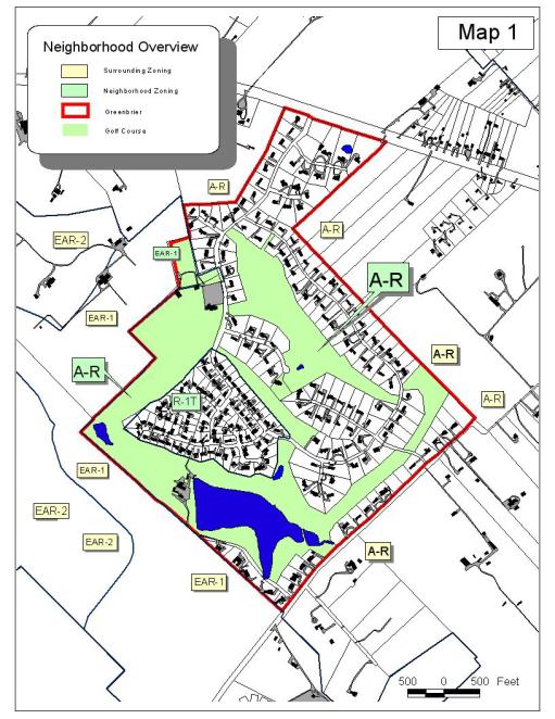
The 409-acre Greenbrier neighborhood (Map 1) was added to the Lexington-Fayette County Urban Service Area (USA) in 1996 as a part of the first major expansion of the USA boundary since it was implemented in 1958. It is located east of I-75, on the eastern most edge of the USA, on the south side of Winchester Road (US 60). It is bounded to the east by ten-acre lots and larger agricultural tracts. It is bounded to the west and south by rural land that has also been brought into the Urban Service Area as a part of the 1996 Expansion. Much of this land is under development or is being planned for urban development. North, across Winchester Road, is agricultural land in the Rural Service Area.
The neighborhood (see Table 1, pg. 6) consists of 145 large residential lots (averaging 1.2 acres), zoned A-R; 90 smaller residential lots (averaging 0.42 acres), zoned R-1T; 5.5 acres zoned EAR1; and a 169-acre golf course, zoned A-R. These areas are described in more detail later in this Plan. The entire Greenbrier neighborhood currently has a future land use designation of Expansion Area Residential-1 (EAR-1), which would allow a maximum build-out of three dwelling units per acre.
History Of Study Area And Planning Issues
During most of the forty-plus years since the Greenbrier community was developed, it has existed as a non-conforming use in the rural area of Fayette County. There are a limited number of comparable one-acre rural subdivisions which exist in Fayette County, all of which also predate subsequent larger lot size requirements. Greenbrier developed in two main phases. The first included the golf course and the one-acre portion of the subdivision. In the 1970s, a 49-acre portion of the neighborhood was zoned R-1T. This area subsequently developed as singlefamily detached homes on lots no less than 15,000 square feet. The majority (87%) of Greenbrier is zoned A-R.
In 1964, based on Health Department recommendations, the County adopted a ten-acre minimum lot size for rural areas of the County, which rely upon individual on-site septic systems to better protect the groundwater and the agricultural economy and rural environment in the County. In 1999, the Urban County Planning Commission adopted a Rural Service Area Land Management Plan, which further recommended increasing the minimum lot size in the Agricultural Rural (A-R) zone to a forty-acre minimum.
As the non-conforming residential areas of the Greenbrier subdivision developed in the 1960s and 1970s, problems with the on-site septic systems became apparent. The developer considered utilization of a private package treatment plant, but the neighborhood objected. The Fayette County Health Department determined that over 80 percent of the groundwater in the area was contaminated.
In the late 1970s, after continuing environmental concerns, the Greenbrier neighborhood worked with the city of Lexington to provide public sewer service to their rural subdivision. Extension of public sewer to this rural area was paid for by a grant and by the neighborhood residents. The twenty-year bond has recently been paid in full by the neighborhood. Construction of the sewers and two pump stations complied with all LFUCG requirements. The lines and pump stations have always been owned and maintained by the Urban County. Additional connections to the existing sewer service were restricted since installation. Now that Greenbrier is included in the Urban Service Area, as a part of the 1996 Expansion Area, all urban services will be available as the surrounding area develops, including improvements to the sanitary sewer system. Except for two lots, the subdivision has been at build-out capacity under the existing zoning for many years.
During the 1996 update of the Comprehensive Plan, a decision was made to add over 5,000 acres to the Urban Service Area. The existing Greenbrier subdivision and golf course were part of that expansion due to goals, objectives, and policies in place at the time. At that time, the Greenbrier residents expressed considerable concern about being included in the Urban Service Area, fearing immediate infill and loss of the unique character of their community. While the 1996 Expansion Area Master Plan contains new land use categories and many special provisions related to how it is proposed to develop, it allocates a land use designation of EAR1 to the Greenbrier neighborhood which would allow the possible redevelopment of the neighborhood at a density of three units per acre (through rezoning).
Many of the concepts in the Expansion Area Master Plan were reached through a community-wide consensus building process that were to be ensured by an Urban County Government-initiated zoning map amendment for the entire Expansion Area. When this zoning map amendment was initiated, it included many special provisions to protect the rural character of the Greenbrier community. When this mass zoning map amendment was not approved by the Urban County Council, recommended
EAR-1 land use designation left Greenbrier vulnerable to more intense redevelopment. One such incident occurred in 2001, resulting in approval for a 5.5-acre tract to be developed into 15 townhouse units. This action reaffirmed the community’s concern about developing a mechanism to ensure the stability of both the residential portions of the neighborhood as well as the golf course land. This SAP is a part of this effort to protect the community’s rural character.
Existing Conditions
The Greenbrier Area Committee conducted studies to provide an overview of all aspects of the natural and built environment, including the present development patterns (streets and structures); infrastructure; tree canopy areas; drainage areas and other environmentally sensitive areas. These studies are reflected and expanded upon in this section of the Small Area Plan.
Land Use and Zoning:
Greenbrier was initially developed as a “rural/ suburban” golf subdivision community in the Rural Service Area (prior to the implementation of the “10-acre rule” in 1964). The entire subdivision (Map 1) is comprised of 409 acres, 169 of which are in golf course uses. The original development was primarily one-acre lots and was zoned Agricultural Rural (A-R). In the early 1970s, a portion of the neighborhood was zoned R-1T. Although this zone permits townhouses, an agreement has limited its development to single family detached homes on lots no less than 15,000 square feet. Map 1 shows streets, lots, and setback patterns.
The existing development pattern is characterized by a large lot/large home pattern on an internal public street system. The street system is essentially rural in character with no curbs or gutters and only partial sidewalks. Setbacks are fairly large, averaging over 75-foot setbacks along most major roads in the AR zoned area, over 100-foot setbacks on some of the cul-de-sacs, and 40 feet in the R-1T area. These setbacks all provide large front yard areas exceeding the requirements of typical residential zones in Lexington.
The A-R zoned area consists of 145 residential lots, averaging 1.2 acres per lot, plus the golf course. The residential lots range in size from 0.56 acres to 3.55 acres, and total 187.5 gross acres. The R-1T zoned area consists of 90 lots, averaging 0.42 acres per lot. These lots are developed as single family detached homes and range in size from 0.33 acres to 0.94 acres, totaling 49 gross acres.
A 5.5-acre portion of the golf course property was rezoned to Expansion Area Residential-1 (EAR-1) in 2001 and is proposed to be developed in 15 townhomes. This rezoning and the concern about the potential for additional EAR-1 development is what precipitated the moratorium, the formation of the Greenbrier Area Study Committee and, subsequently, the development of this SAP.


