5 minute read
Indian Hills Small Area Plan


The Single-Family Homes:
One of the remaining single-family homes is currently owner-occupied and the other three are renteroccupied. The single-family home at the end of the plan boundary, 3116 Harrodsburg Road, furthest from Corporate Drive, is a stone ranch home of approximately 1,400 square feet with a 1,400 squarefoot basement and it is situated on a .68-acre lot. The other three homes, 3090, 3094, and 3098, are smaller and are built on .66-acre, .57-acre, and .62-acre lots, respectively. These three rented homes were subject to some code enforcement action in 2002 for debris and appliance removal.
The Three P-1 Lots:
Located at the northern end of the plan boundary closest to Corporate Drive, are the three, currently zoned, P-1 lots. These three lots were developed according to the “Corporate Center Office Park” development plan. On the corner lot at Corporate Drive and Harrodsburg Road is 3060 Harrodsburg Road, which is currently occupied by a bank, with its related offices on the second floor. The building at 3060 is two stories with approximately 14,600 square feet. The buildings at 3070 and 3080 have 12,447 and 17,208 square feet, respectively, and both are two stories. It was reported that 3060 has no vacant office space, 3070 has 4,800 square feet vacant, and 3080 has 4,361 square feet vacant.
(See Appendix 4)
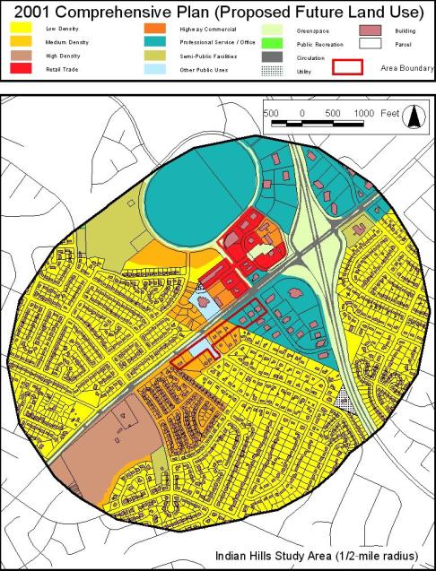
Land Use and Zoning:
The 1996 Comprehensive Land Use Plan designated the three properties at 3060, 3070, and 3080 as Professional Services and the remainder of the lots in the IHSAP boundary as Medium Density Residential. The medium density residential land use did extend to the 8 lots fronting on Tomahawk Trail and Apache Trail behind the lots in the IHSAP area. The remainder of the Indian Hills Subdivision Unit 1 remained designated as Low Density Residential. The three lots designated as Professional Services were zoned P-1 in 1978. The Indian Hills Unit 1 Subdivision, which included the remainder of the lots in the IHSAP boundary, was zoned R-1B in 1968 and is R-1B today.
The 2001 Comprehensive Land Use Plan changed the recommended land use for the four lots that made up the fire station property to Other Public Uses. The rest of the land uses for the properties in the IHSAP boundary, as well as all lots abutting the IHSAP boundary, stayed the same as they were in 1996. A
Conditional Use for the Masonic Lodge development on 3112 Harrodsburg Road, plus two lots abutting it, 864 and 868 Apache Trail, was approved by the Board of Adjustment on September 28, 2001. Those three lots have been consolidated but construction has not begun to date.
To analyze the land use mix, the land located within a ½-mile radius of the IHSAP boundary was included in data collection. The table above displays the zoning mixture in the ½-mile buffer of the IHSAP.
The chart above shows the total acres for each zone in the .5-mile buffer of the IHSAP. These totals do include the acres within the plan itself. (Please note that much of the LD land shown in the table at the top of this page is already developed with R-1B and R-1C zoning, which means larger lots and a density at the lower end of the range for Low Density.)
Above is a chart showing the land uses from the 2001 Comprehensive Land Use Map for the same .5-mile boundary of the IHSAP. On page 13 is a map depicting the 2001 Comprehensive Plan Future Land Uses within 1/2-mile of the IHSAP, with the land uses and zoning, charted on this page, located within the oval boundary on the map.
The Land Use bar chart shows Low Density Residential (LD) as being a much greater land use than any other category, with Professional Services (PS) being the second greatest. LD makes up 52.84% of the land use and PS makes up 17.20%, which is one-third the amount of the LD. A visual inspection of the 2001 Land Use Map above shows this portion of Harrodsburg Road to be recommended as a Residential and Professional Office Corridor.
Current zoning of the land within the ½-mile boundary of the IHSAP shows 55.74% is zoned low-density zones, R-1B, R-1C, and R-1D. The 2001 Comprehensive Plan shows 52.84% LD. There are uses zoned R-1B and R-1D that are categorized as Other Public Uses and Semi-Public Uses on the 2001 Comprehensive Plan Land Use Map . Also, there are some properties zoned R-1B that are on the 2001 Comprehensive Plan Land Use Map as Medium Density Residential. This accounts for some of the differences between future land use and zoning.
Interestingly, if you look at the 2000 Census Summary File 3 data for the census tracts involved by this ½-mile radius of the plan area (tracts 42.02, 36.00, and 29.00), an occupational trend exists. The majority of the people in these census tracts are employed as management, professional, and related occupations; and the second highest area of employment in these tracts is in sales and office occupations.
The small portion of the ½-mile boundary area, which lies inside New Circle Road on the southeasterly side of Harrodsburg Road, is part of Census Tract 9.00. This area is a small portion of the area captured by the ½-mile boundary. The areas of the ½-mile boundary outside of New Circle make up most of this analysis area. Those areas are in Census Tract 36.00 and 42.02. As you can see from the table below, Tracts 36 and 42.02 have a higher concentration of management, professional, and related type occupations than the County as a whole. About 81 to 85% of the employed people in Tracts 36 and 42.02 are in management, professional, sales, and office related occupations. Having more Professional Services land use in the vicinity of their place of residence reduces traffic congestion, air pollution, and travel time.
Below is a table showing data extracted from 2000 Census Summary File 3 Table: GCT-P13.
16 Years and
2000
E nce na e int a M ions t ccupa O ion, oduct Pr %, ion Pr % ion, oduct on, uct o %, ion, t a t por ns a Tr l ia r e t a M nd a oving M ions t ccupa O
Environmental Conditions:
Soils for the plan area are Maury silt loam, which is prime Agriculture soil. This soil type is suitable for farming, as well as development. There are no mapped sinkholes, springs, steep slopes or significant tree stands. Contour lines and elevations on the topographic map indicate that surface storm water flows away from the Indian Hills Subdivision Unit 1 neighborhood, over the IHSAP properties towards swales and culverts along Harrodsburg Road. Only 3112 and 3116 Harrodsburg Road are properties where the surface storm water flows toward some lots in the Rabbit Run subdivision at the end of Blenheim Way, nearer to Harrodsburg Road.
A portion of the fire station lot, which originally was 880 Apache Trail, is at a higher elevation than the surrounding properties. It is currently a green space with grass and several trees. This portion of the property is a good buffer to the fire station and creates a nice transition from the public use to the residential uses, although the existing trees did receive some damage from the 2003 ice storm. The fire station rear and side yards are screened by a wood privacy fence and trees.
Harrodsburg Road is a major arterial and it is planned to be widened. Therefore, noise is a concern for this established residential neighborhood. The fire station was a necessity and was developed with screening to try to buffer some of the noise and activity. And having CPR trained professionals in close proximity to a neighborhood with an aging population is a plus.
Public Facilities/Infrastructure:
The Indian Hills Subdivision Unit 1 was developed in the early 60s with the homes using septic tanks. However, in the early to mid-90s, all of the homes were added to the sanitary sewer system. The sanitary sewer pipes to the future Masonic Lodge property have been capped since the structures have been razed.
According to LFUCG. Engineering staff, the storm water system in Indian Hills is “scant and overloaded.” Any additional water being directed into the Beaumont system would need to be input into that drainage study. A recent proposal for a motel included detention; and had it been approved, it would have required off-site pipe construction to get the water to the system.


