Life and Culture in Northeast India

3 UNESCO World Heritage Sites
Dipti Bhalla Verma • Shiv Kunal Verma

The eight states of India’s Northeast make up only 8 per cent of the country’s land mass, but they are home to over one hundred tribes, each with its own unique culture. The terrain, predominantly hilly, ranges from snow-capped Himalayan peaks to tropical rainforests, and the national parks and preserves contain exceptional scenery and an abundance of wildlife, from red pandas to snow leopards. Now, for the first time, noted documentary filmmakers and photographers Dipti Bhalla Verma and Shiv Kunal Verma provide a comprehensive introduction to this little-known yet captivating part of the world.
Bhalla and Verma conduct us from the towering Kanchenjunga massif in Sikkim to the tea plantations of Assam, to the astonishing biodiversity of Arunachal Pradesh, to the martial tribes and Baptist churches of Nagaland, to the birthplace of polo in Manipur, to the living root bridges of Meghalaya, to the farms nestled among the hills of Tripura and Mizoram. The authors take us into the lives of the many peoples of Northeast India, who maintain their traditional customs and beliefs even in the face of growing ecological threats. They trace the history of the major population groups from the earliest records to the present, and illustrate their characteristic art forms, from dance to architecture. Special sections are devoted to Manas Wildlife Sanctuary, Khangchendzonga National Park and Kaziranga National Park, all three UNESCO World Heritage Sites.
Featuring more than three hundred colour photographs and twelve detailed maps, Life and Culture in Northeast India will be an essential volume for anyone interested in the peoples and places of Planet Earth.
With 318 photographs and 12 maps.
For Vallika and Veeha, Who will take the story forward to ever-expanding horizons…
 Dipti Bhalla Verma and Shiv Kunal Verma
First published in India in 2020 by Mapin Publishing Pvt. Ltd
706 Kaivanna, Panchvati, Ellisbridge
Ahmedabad 380006 INDIA
T: +91 79 40 228 228 • F: +91 79 40 228 201
E: mapin@mapinpub.com • www.mapinpub.com
Simultaneously published in the United States of America in 2020 by Abbeville Press
655 Third Avenue, Suite 2520, New York, NY 10017
T: +1 (212 )366-5585
E: abbeville@abbeville.com • www.abbeville.com
Text and photographs © Dipti Bhalla Verma and Shiv Kunal Verma, except where mentioned otherwise.
All rights reserved under international copyright conventions. No part of this book may be reproduced or transmitted in any form or by any means, electronic or mechanical, including photocopy, recording or any other information storage and retrieval system, without prior permission in writing from the publisher.
The moral rights of Dipti Bhalla Verma and Shiv Kunal Verma as authors of this work are asserted.
ISBN: 978-93-85360-25-1
Copyediting: Mithila Rangarajan / Mapin Editorial Design: Darshit Mori and Gopal Limbad / Mapin Design Studio
Production: Mapin Design Studio
Printed in South Korea
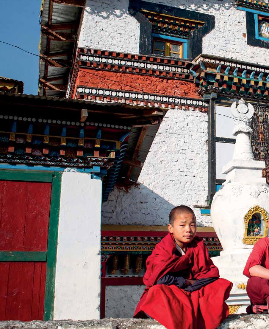
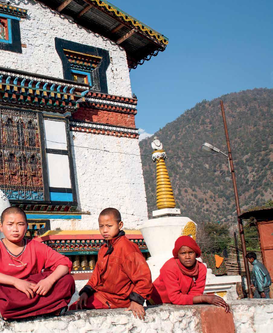
page 1 | The Tangkhul are simple people and the women have much the same status as men. Today the prime focus of the Tangkhul is to revive and re-establish their traditional art and culture. Accordingly, certain earlier festivals are still observed. Among these, the eleven-day-long Luira is the most important. It is celebrated with sacrificial offerings and preparation of khor, the traditional rice beer.
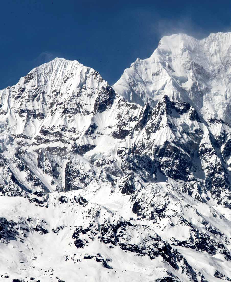
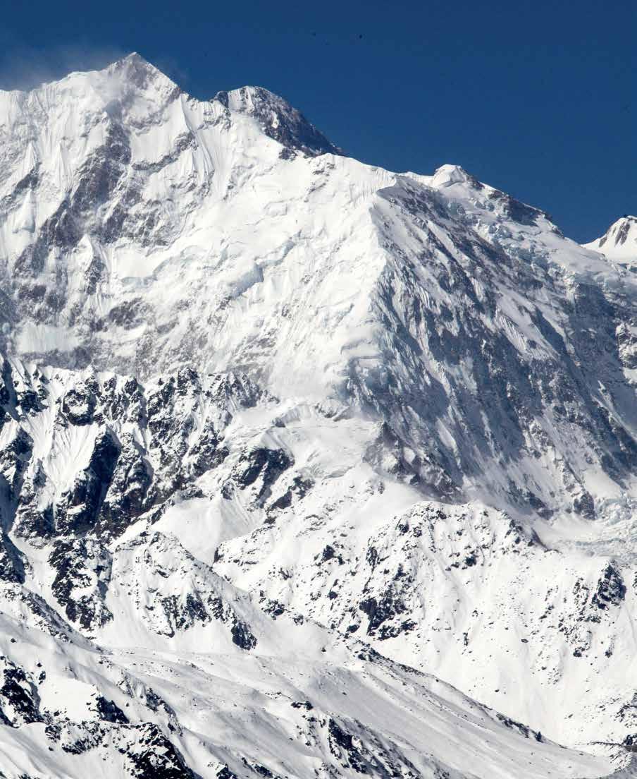
pages 2–3 | Until 1852 the Kanchenjunga Himal was considered to be the highest mountain in the world, with the Singalila Ridge separating Nepal from Sikkim. Calculations made from multiple readings during the Great Trigonometrical Survey of India in 1849 then gave Everest that honour, with Kanchenjunga now being recognised as the third-highest mountain in the world, after K2.
pages 4–5 | A Cheetah helicopter’s rotors push its limits, rising to these rarefied heights to capture a spectacular view of the less familiar north face of Kanchenjunga. A rare day, when against cloudless skies the planet’s third-highest peak paints a magnificent picture.
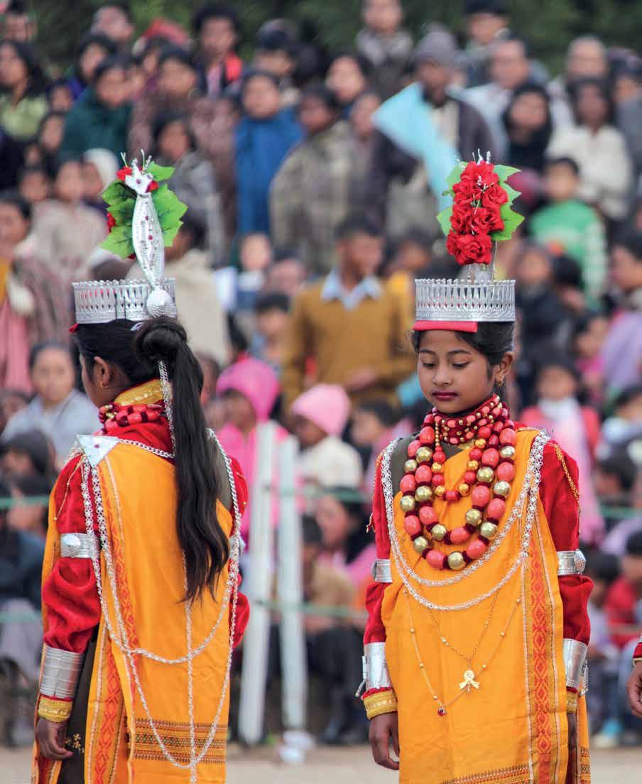
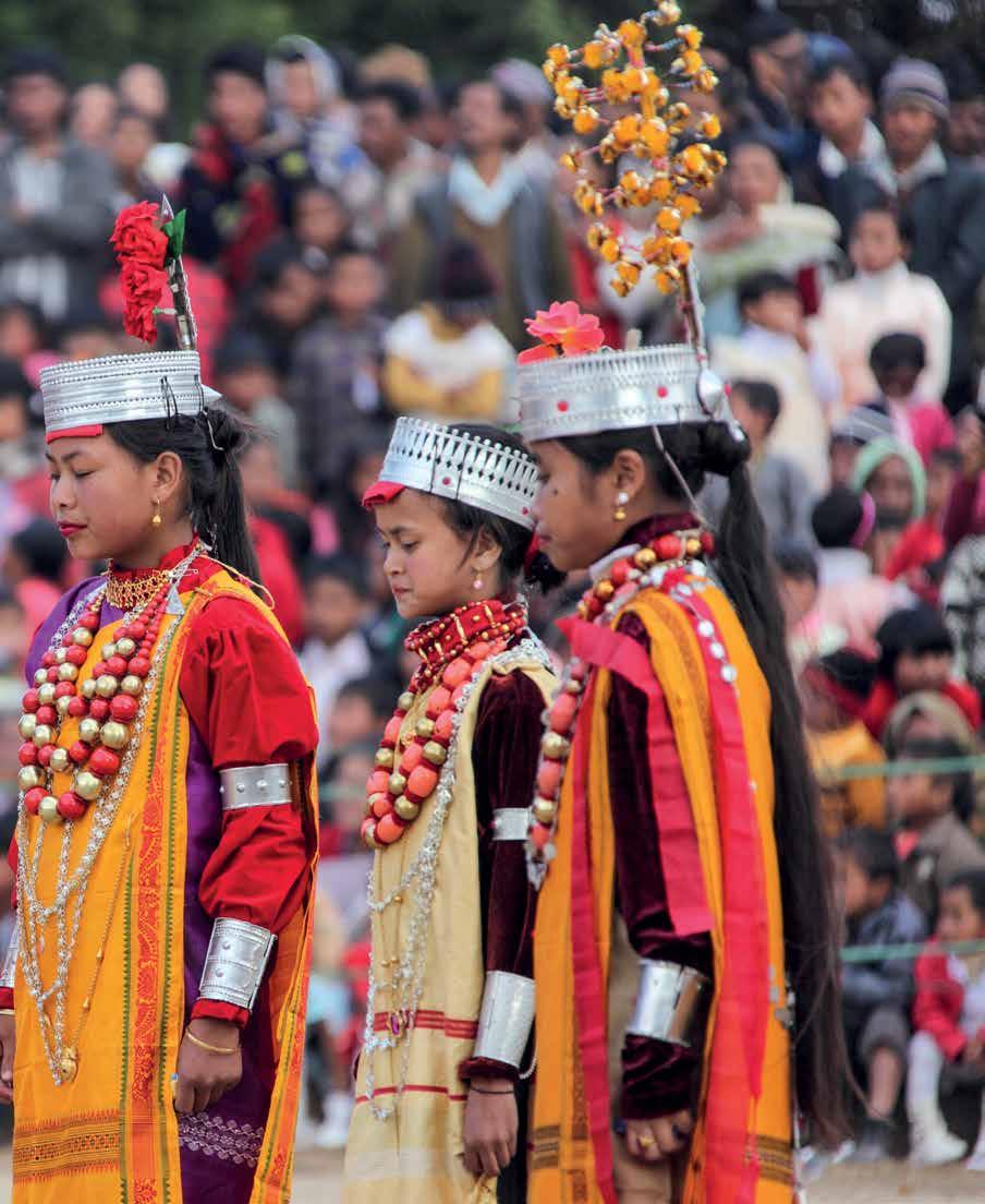
pages 6–7 | The crowning glory of all Khasi festivals is the ancient and hugely popular Ka Pomblang Nongkrem. A thanksgiving ceremony for a good harvest, the celebrations around Nongkrem extend over five days, and the religious rituals often give over to the dancing. It is celebrated every year at Smit village, 11 km (7 mi.) from Shillong. Photograph by Somu John Ingty.
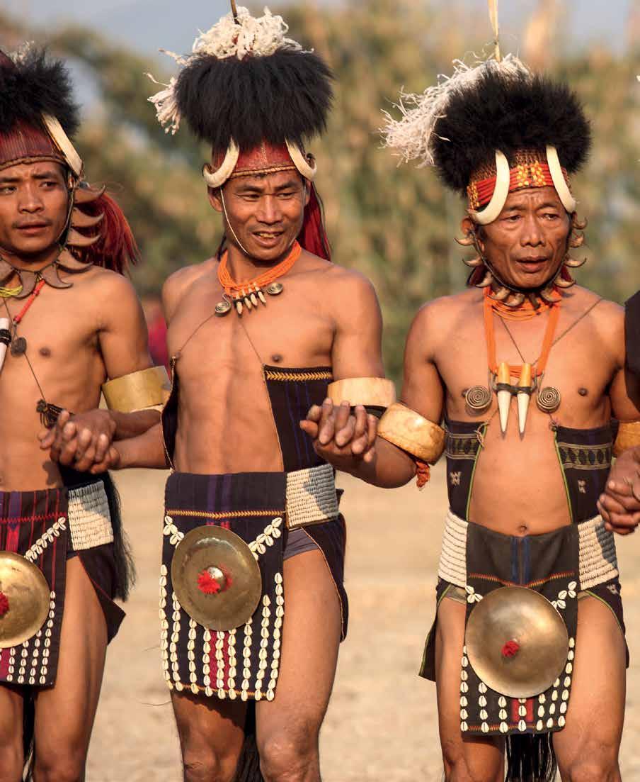
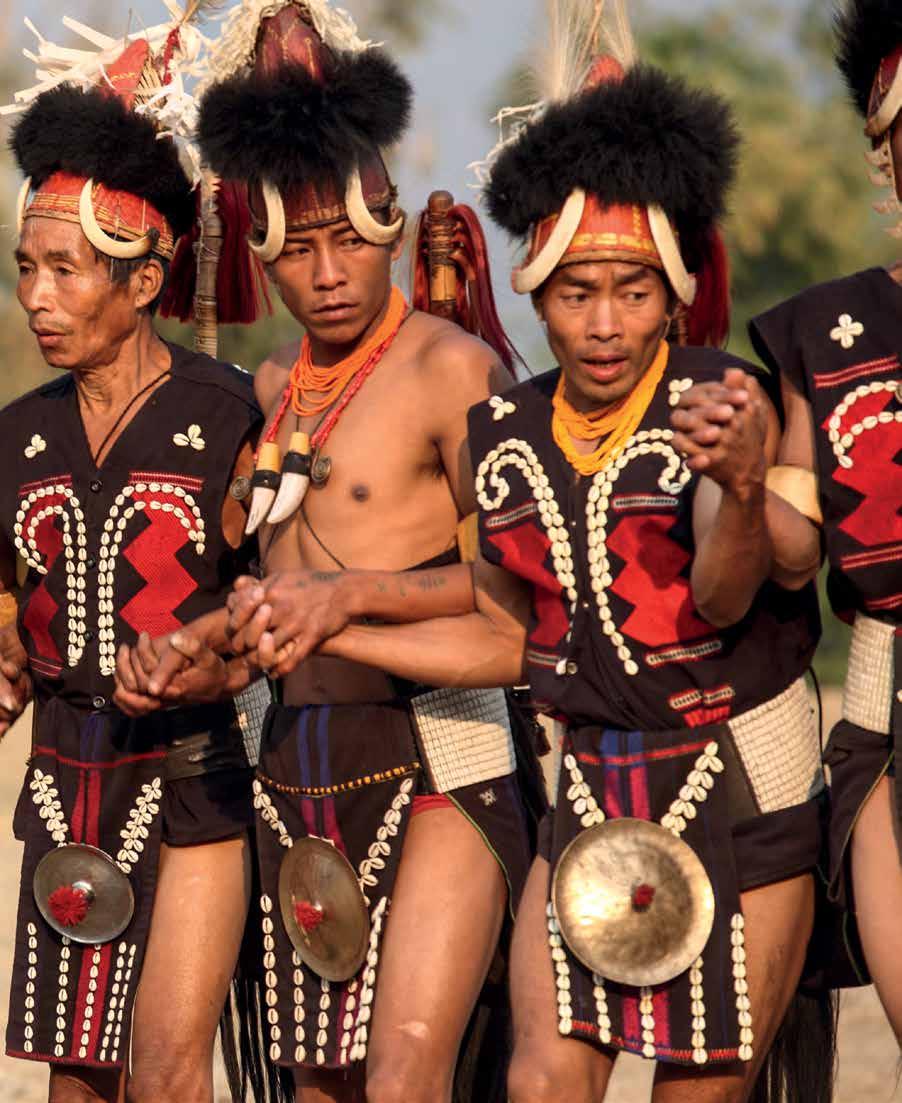
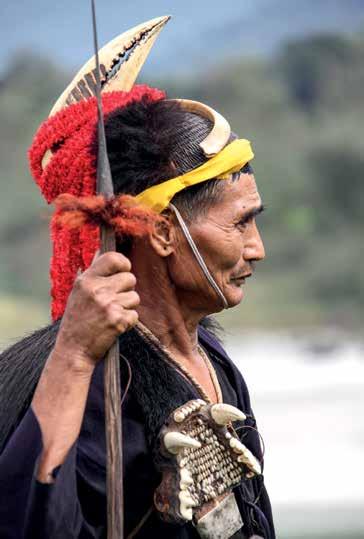
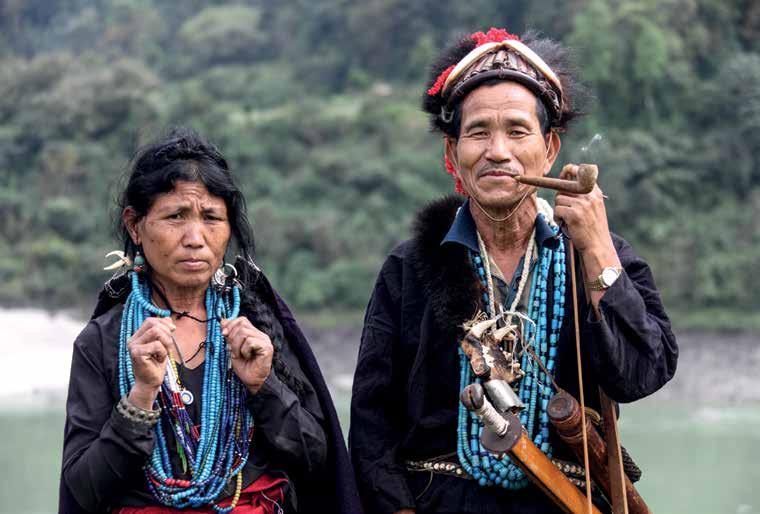
pages 8–9 | The Chang, of the central section of the hilly Tuensang District, are believed to have originated from a place known as Changsangmongko. Initially, they settled at Changsang, where chongnu, the mythical banyan, grew, giving the tribe its name. The Chang believe that they belong to the same ethno-cultural stock as their neighbours— the Konyak, the Ao, the Khiamngan and the Yimchunger.
pages 10–11 | From time immemorial in the Khasi and Jaintia Hills, unspoilt virgin forest, called Law Lyngdoh, has been revered as a sacred grove. Not far from Shillong, the village of Mawphlang has such a forest near it, which has been left undisturbed, as the people believe that the sylvan deities will be offended if the trees are cut or the flowers and fruits plucked.
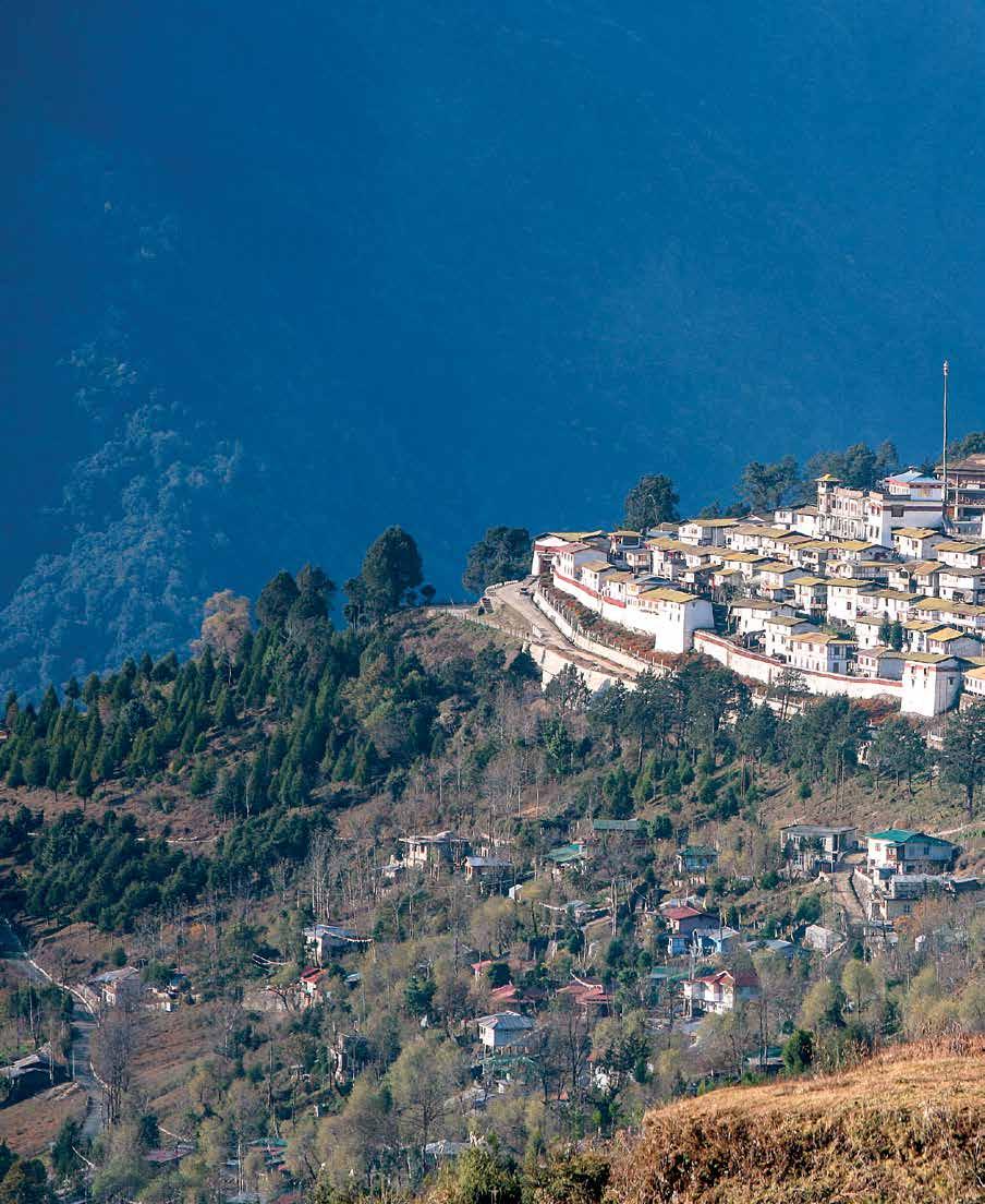
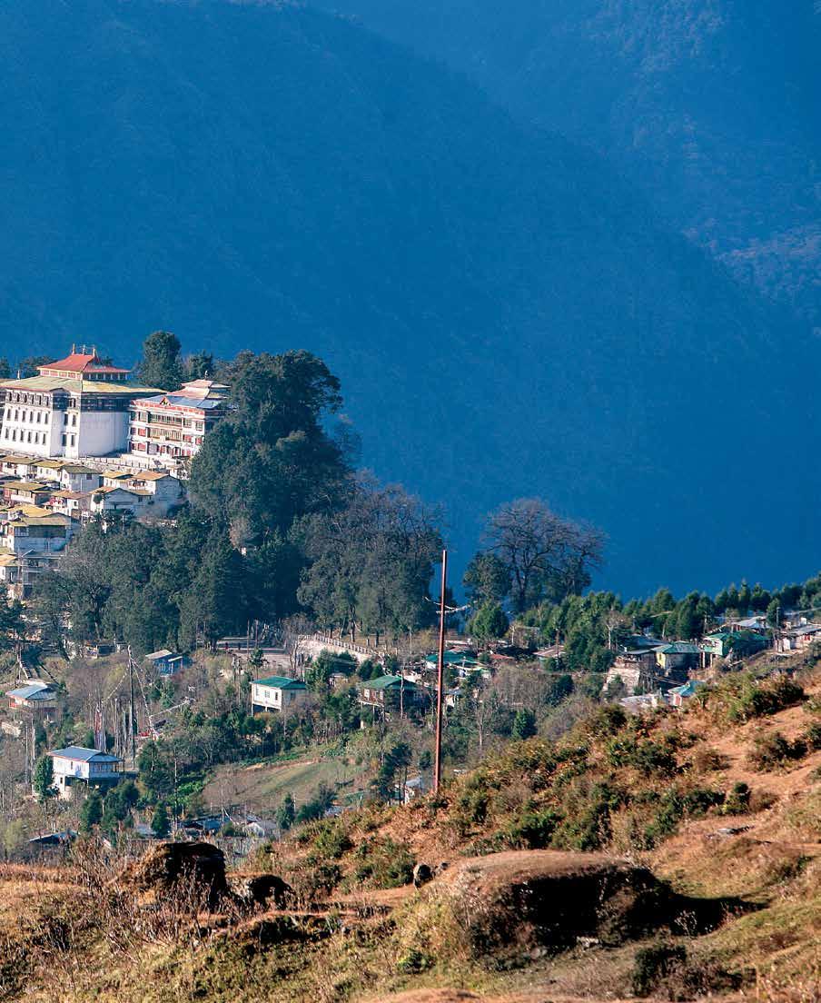
pages 12–13 | Merak Lama Lodre Gyatso founded the Tawang Monastery, whose Tibetan name means “celestial paradise on a clear night”. The name “ Tawang” itself came from ta, Tibetan for “horse”, and wang, meaning “blessing”. Built on a spur, it commands a view of the Gudpi and Chong-Chugmi Ranges, while the valley of the Tawang Chu lies below.
page 16 | During British times the Nyishi were referred to as “Dafla”. They sometimes raided the plains of Assam, which in turn lead to military expeditions into the area to “punish the tribes”. Contrary to the popular belief that the word dafla was used to denote a “savage”, it probably originated with the Assamese, who used it to describe a robust physique. For example, a good-looking Assamese girl is even today called a dafli
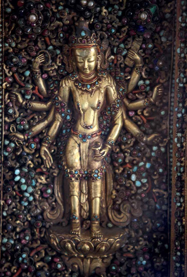
page 19 | A fusion of styles comes together in this gem-studded, multi-armed Buddha, belonging to the Tripura royal family. The plains of Tripura were under the control of several dynasties that ruled in Eastern Bengal and Samatata during the ancient period. Some of these were of the Buddhist faith, while others were Hindu.
BAY OF BENGAL
This map has been created based on Record/Master Copy certified by Survey of India. • The responsibility for the correctness of internal details rests with the publisher. • The territorial waters of India extend into the sea to a distance of twelve nautical miles measured from the appropriate base line. • The interstate boundaries amongst Arunachal Pradesh, Assam and Meghalaya shown on this map are as interpreted from the “North-Eastern Areas (Reorganisation) Act. 1971,” but have yet to be verified. • The spelling of names in this map have been taken from various sources.
It was almost twenty years ago that Dipti and Kunal made a short film on Manas Wildlife Sanctuary. It was very important as we were all working on the revival of this UNESCO World Heritage Site that had been ravaged due to militancy over the past couple of decades. That was the introduction, but since then we kept in touch because of our common involvement with India’s Northeast. Being from the region, I have been a part of some of the journeys with Kunal. It is his images that interpret both the history and the present story of the region, further enhanced by Dipti, who binds them with the right words. Few people in this world realise that a very important part of India begins from here.
How many of us know that the Lepcha have a story akin to Noah’s Ark? The entire region described in this book probably has more cultures than the rest of the country put together, and several of the tribal communities place their faith in “biodivinity”. Please do not call it “animism”, as it is more advanced than the organised religions of the world. Here, they have learnt to depend on their immediate biodiversity for their basic needs of food, clothing and shelter. This is the science of sustainability that our Northeastern communities have been practising for generations, while the world is struggling to achieve sustainable development goals, now that resources have come under tremendous pressure.
Look at the emergence of modern civilisations that were connected through trade: the maritime route, also known as the “rice route”, that ran from Chittagong, and the mountain route through Sikkim, known as the “silk route”, that connected Lhasa with the rest of the world through this region. These trade routes then introduced the world to a variety of weaving methods, items like terracotta, and agricultural produce that included certain varieties of rice, corn, sweet orange, mango and other produce that are now part and parcel of our daily lives. Every 20 km (12 mi.) that you travel in this region, you will be introduced to a new culture, language and lifestyle, very different in origin, finding their roots somewhere in Asia. A lot of this cultural diversity is also because of the diverse landscape so typical of the Northeast.
it was not known for a long time that the entry of the Yarlung Tsangpo as the Siang, having negotiated the great bend around the Namcha Barua massif, was in fact the mighty Brahmaputra itself, coming into its own where the waters of the Lohit and Dibang Rivers meet at Sadiya. The Lohit, described by pandits as extending from Brahmagiri to Brahmakund, flows through a landscape where so much has happened along its banks that it will probably need a few hundred books to be described. The spirituality that we boast of today in India is a journey that also encompassed Pragjyotishpur, the area being dominated by the Kamakhya, Hajo and Madan Kamdev Temples, as well as several lost temples. Unlike the rest of the country, the dominance of the matriarchal society still remains the pride of India’s Northeast, and much of it is reflected in the weaves and culture of this region.
Even though this book delves into each and every corner of the Northeast as per the current political borders of the states, it focuses on the four major zones with equal intensity, transcending conventional borders. The first of these is the major Kanchenjunga landmark that then extends eastwards as the Assam Himalaya; the second zone comprises the great Brahmaputra and Barak River Valleys and their headwaters; the third is the Jaintia, Khasi and Garo Hills that geographically separate the region from the flood plains of Bangladesh to the south and west; and the very fascinating fourth part is the region that encompasses the Dihing Patkai landscape, extending into Myanmar further to the east, which in recent history was a part of the China-Burma-India theatre during World War II. The pictures and descriptions make this a dream journey through a hitherto under-explored region. This book opens a window that will help you sink into the inner depths of India’s Northeast, through the insight of every image and the narrative that is presented through the eyes of Dipti and Kunal.
Raj Basu 大罗
Unlike the other great river valleys of India, the Brahmaputra River Valley is still relatively less known. As described in this book,
Association for Conservation & Tourism (ACT) is a grassroot level ‘not for profit’ organization, established in 2001, which has shown the way for Rural Tourism as a tool for empowerment of local communities, helping in poverty alleviation and establishing peace in India’ s West Bengal & Northeast, Eastern Nepal, Northern Bangladesh, Bhutan and Myanmar
Let there be bliss of good harvest, Let the earth be full of minerals, Let the nest of birds be full with eggs and chicks, Let the earth be filled with wealth, Let knowledge increase.
The hearth may keep on burning, So that new leaves may unfold, So that bamboo may grow and spread, So that rivers may be full with fish and shrimp, So that the field is full of grain. So Mother Mopin, Let the human cycle of life Be filled with plenitude.
— Adi Minyong prayerIndia’s Northeast is a land where nature, in its multifarious physiological and climatic manifestations, has from time immemorial held the lives of the people in the palm of its hands. On the subcontinent, the gap between the Himalayas and the Indian Ocean is at its narrowest here. This geographical factor has resulted in the greatest diversity of insect, plant and animal life. Not so surprising, then, is perhaps the fact that the area also has the largest diversity in the number of human races that have migrated into and made the region their home. The topography of the region may have influenced the migratory patterns over time, but by the beginning of the nineteenth century, this complex web of people had more or less settled down. Survival, then, perhaps depended on each group zealously guarding its ethnicity, a fact that suited the earlier policy of the colonial masters, who furthered the divide in their quest to rule. Like elsewhere in many parts of India, this constant past remains—a reminder of a bygone era, yet coexisting with absolute ease with the evolving present.
The eastern sweep of the Assam Himalayas dominates this incredible landscape, physically defining the northern borders
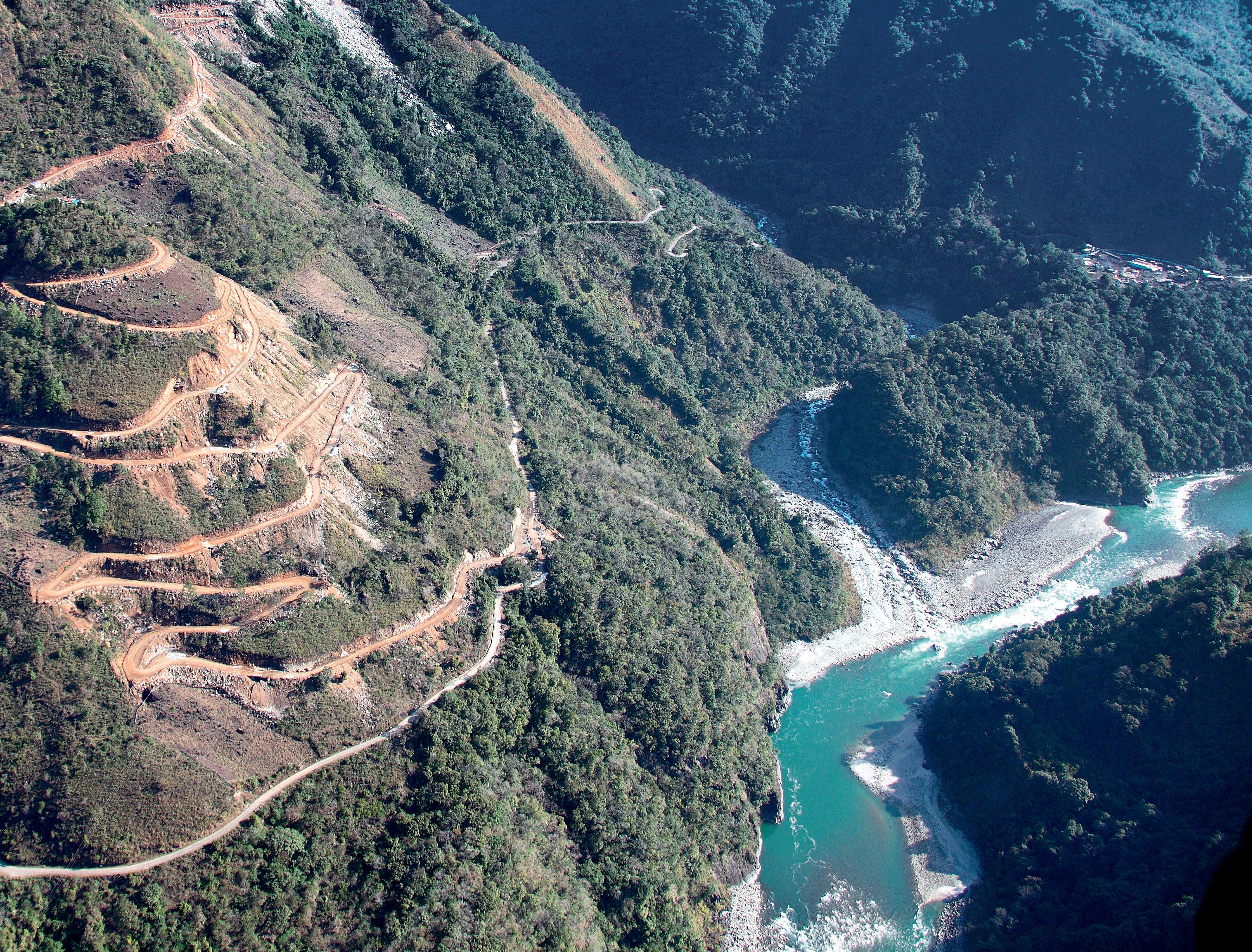
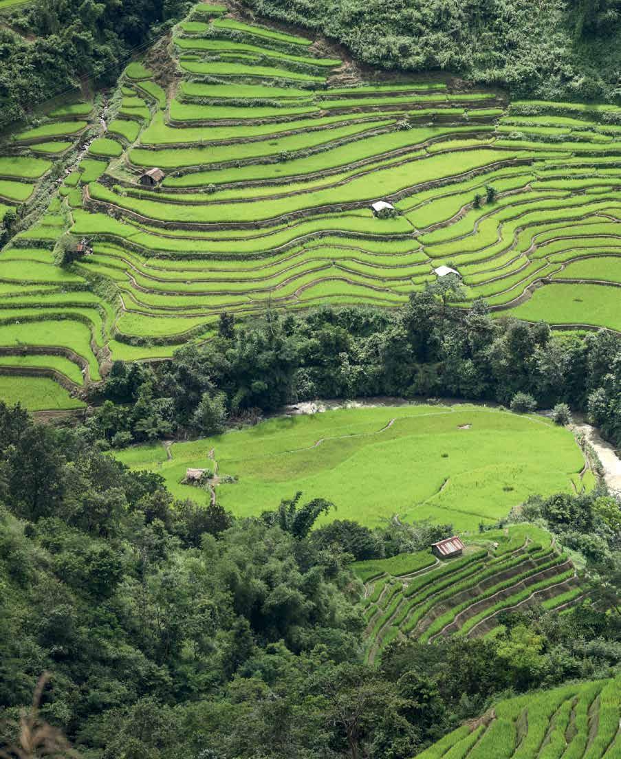
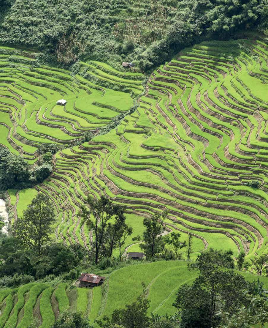
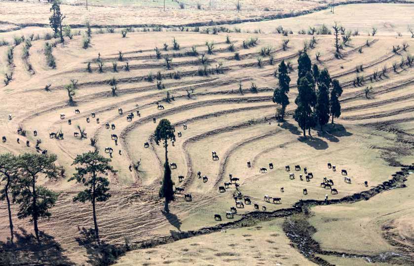
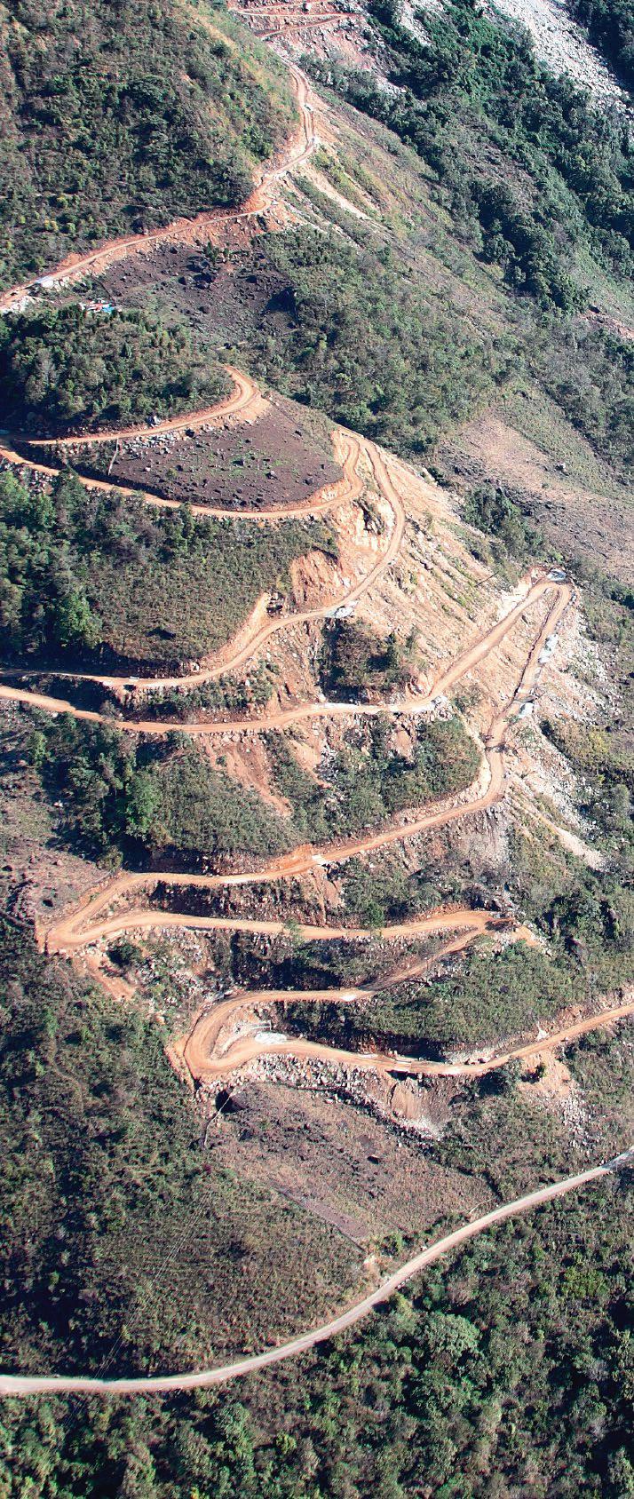
Step-cultivation is to be widely seen across the mostly hilly terrain of the Northeast wherever there is a village or hamlet. The carefully tended beds offer a picturesque sight, drenched in green.
of the region. The Tsang Po descends into India through a gap in the Great Himalayas at Gelling, flowing through the heart of Adi country as the Siang River, and then debouches into the Assam Plains at Pasighat. There the formidable waters of the Siang mix with the Dibang and the other great tributary, the Lohit, which enters Arunachal Pradesh from Tibet at its extreme northeastern corner at Kibithu. It is here, at the confluence, that the Brahmaputra is born and together the waters flow in a southwesterly direction, annually claiming the plains as their own, swelling and receding across the vast low-lying region of Assam.
Starting from the eastern flank of Arunachal Pradesh, where the warmth of the first rays of the sun are felt, another great north-south mountain chain, the Naga Patkai Hills, extends into Nagaland and Manipur, linking up with the Chaifil Tlang and the Uiphum Tlang Ranges in Mizoram before tapering off
into the Chin and the Arakan Yoma. Along the southern bank of the Brahmaputra River are the east-west aligned Jaintia, Khasi and Garo Hills that make up the state of Meghalaya, which in turn separate the river valley from the low-lying areas of Bangladesh to the immediate south. After India’s independence and the partition of the subcontinent, the resultant narrow tract of land, the Siliguri Corridor, or “Chicken’s Neck”, became a slender thread that acted as the sole gateway to the entire region, further extenuating its remoteness and defining its isolation. Once this narrow gap is traversed and the traveller journeys through Sikkim, part of northern West Bengal, Assam, Meghalaya, Arunachal Pradesh, Nagaland, Manipur, Tripura and Mizoram, this often unfamiliar part of the country steps forward in all its geophysical, anthropological and folkloric splendour.
The Himalayan Range is the youngest mountain chain in the world. Ecologically, the region is extremely fragile, prone to landslides and other disturbances. The Assam earthquake of 1950 had virtually altered the face of the Dibang River Valley as entire villages were wiped out. Draining the valleys is a complex network of rivers, all of them tributaries of the Brahmaputra but major rivers in their own right. Often people on either bank have very little to do with each other. Not just the rest of the country but even within the Northeast, communities know very little about each other, most areas having evolved as compartmentalised geographical entities. Until as recently as the early twentieth century, the link between the Tsang Po and the Brahmaputra had yet to be established, with the remoteness of the region it flowed through only adding to its overall mystique.
left | A warrior from the Adi Bobum Bokang tribe guards his village next to the Siang River near Tuting. Until the beginning of the twentieth century, the area was virtually closed to the British owing to violent opposition from the Abor tribes. However, ingress into the region was inevitable if the ground had to be prepared for the drawing up of the international border with Tibet. Due to the increased Chinese influence over the region, Anglo-Chinese relations were strained from the beginning of the previous century.
facing page
The Adi Shimong are said to have migrated from Tibet to the Nigong Valley. Besides the Adi Ashing that inhabit the area around Tuting, the Adi Tangam migrated to Kuging from the upper gorge of the Siang. The Padam and Pangin tribes downstream stopped their migration further south. Also scattered on the east bank of the Siang are some Idu Mishmi settlements. Though adept at making cane bridges across even the most daunting of rivers, the Adi are generally wary of stepping into rafts or boats to cross the great waters.
This seclusion, however, was and is relative—the Northeast is perhaps the hub through which the country’s connectivity with the rest of Southeast Asia can and will develop. The security of the region, both emotionally and tactically, is also vital to India’s long-term economic advantage. In the plains and in the hills, many ethnic and sub-ethnic identities exist. Together they share through language, culture, migration and history, as also religion and faith, an anthropological connectivity. Yet this ethnic identity can be a double-edged weapon; it can bring people together or divide them from one another.
India’s Northeast was regularly breached by the Burmese in their centuries of conflict with both the Manipuri and Ahom kingdoms, but it was during the Japanese invasion of World War II that the region came into sharp focus. The British opened up the area, pushing the boundaries of their colonial empire; influence and economics were the twin pins on which their policies revolved. World War II changed the profile of the area as
the Japanese pushed forward towards the plains of Assam. Ever since, political change has been a constant factor in the lives of the people; the division of Bengal at Independence brought with it its own problems, which contributed to the continued isolation of the region. After Independence the country adopted its own Tribal Policy with respect to the hill areas of the Northeast. This hoped to preserve the existing cultures while at the same time offering the people a collective identity, a participative democratic political system and, essentially, the platform of nationalism to set aside their differences and build towards the future.
Nagaland was given its own identity in 1963, Meghalaya in 1972, Mizoram in 1986, and Arunachal Pradesh a year later, in 1987.
following pages
Rupa Monastery: The two western districts of Arunachal Pradesh— Tawang and West Kameng—are almost entirely Buddhist. In the Kameng region, the Sherdukpen are concentrated in the Dirang and Singte Valleys and also the Kalaktang (Bomdila) area, while the Monpa are settled in the Tawang Valley.
The Northeast shares international boundaries with Nepal, Bhutan, China, Myanmar (erstwhile Burma) and Bangladesh. This quite naturally has major security implications for the rest of the subcontinent. Further complicating the issue, the general impression of the Northeast today is synonymous with insurgency and underdevelopment, especially in Nagaland and Manipur. Add to this natural disasters, uncontrolled migration, and the displacement of entire peoples—all of which have had a cumulative impact in adding to the constant ferment in which the Northeast finds itself.
In the seven decades that have elapsed since Independence, India as a whole is a changed country as more and more people move across the subcontinent, breaking out of regional and clannish cliques in search of a larger national identity. At the same time, ethnicity, which had always been central to their existence, is
now becoming even more critical as they try to cling to their unique lifestyles. Surveys based on linguistic and anthropological data estimate that there are 475 ethnic groups in this region that speak some 400 languages. This mass of some 46 million people therefore offers us a great opportunity to look at one of the most exciting regions of the world, a region of which even today very little is known to the outside world.
At the time of Independence, Arunachal Pradesh—then known as the North-East Frontier Tract (NEFT)—was largely unexplored and, to a great extent, un-administered territory. The British government had been quite content to exercise loose control over the area south of the Great Himalayan wall, secure in the belief that there was no external threat to the Raj from this axis. A handful of people did make inroads into the area, leaving their imprint on the region, which only just allowed for a peep
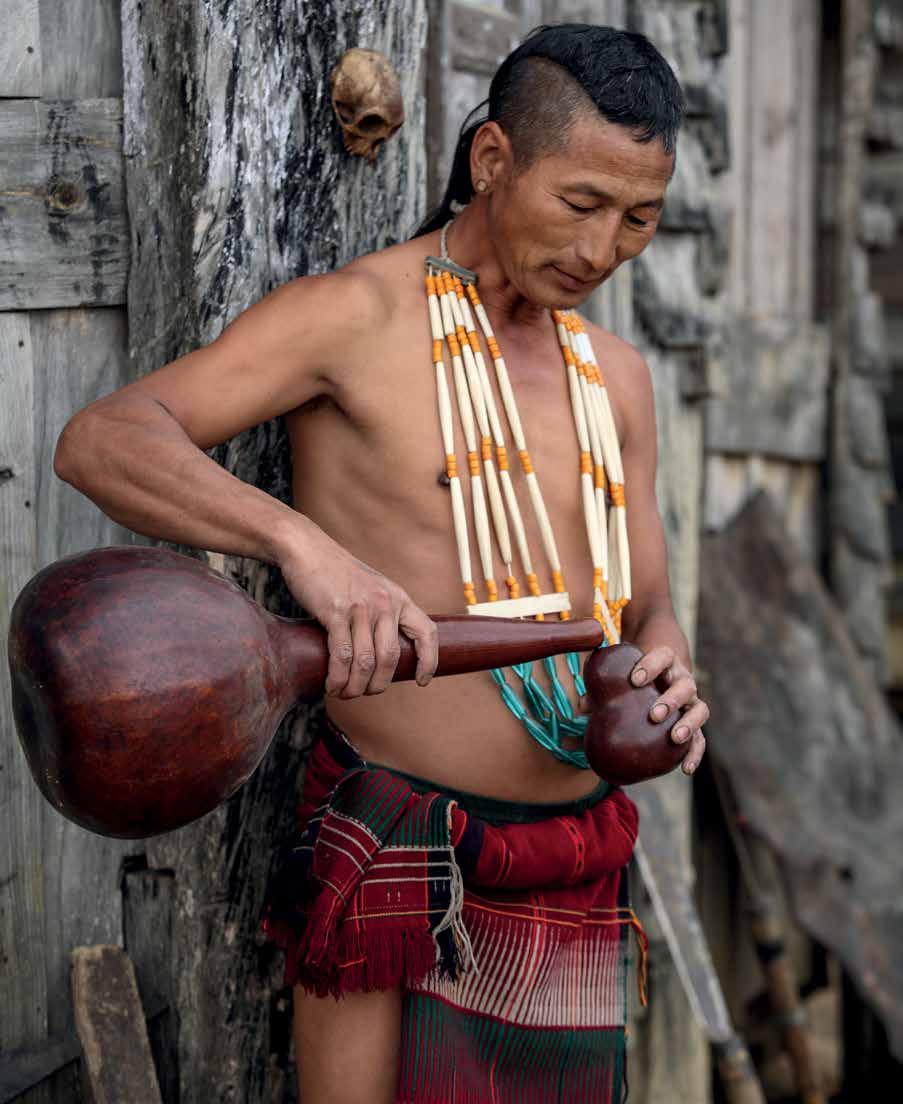
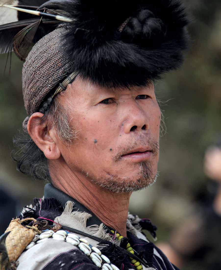
right | Tirap District not only shares a border with Nagaland but also houses two Naga tribes—the Nocte and the Wancho, or the Eastern Nagas—ethnically related to the Konyak tribe. The Nocte inhabit southwestern and central parts of the district and account for forty-five per cent of its tribal population.
facing page
Heads of cattle dot the Khasi countryside. Meghalaya lies to the south of Assam, the hilly areas between the Brahmaputra Valley to the north and the low riverine plains of Bangladesh to the south. Geographically known as the Meghalaya Plateau or the Shillong Plateau, it is an important part of the Northeast’s topography.
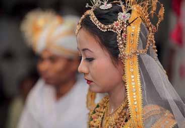
A Manipuri bride. The beauty of Manipuri women is legendary and the wedding ceremony brings to the fore all the perfection and purity in their Vaishnava practices. The main wedding ceremony of the Meitei is called luhongba. It is customary for the bride to wear the Ras Leela skirt.into the mist-shrouded valleys of dense jungles and fierce warlike tribes. Notable among them were Colonel Frederick Marshman Bailey and Captain Henry Triese Morshead, who ventured into the Dibang Valley and then surveyed and charted the entire Himalayan watershed. Their work greatly influenced the demarcation of the McMahon Line that was drawn up in 1914 between the British and the Tibetans. (Tracing their initial route up to Yonggyap La, the authors successfully managed to photograph the pass, from where the massif of Namcha Barua was also clearly visible [see page 127]).
Others followed—Frank Kingdon-Ward, the renowned botanist and naturalist, who not only did pioneering work on the flora of Assam but also solved the mystery of the “Great Brahmaputra Falls”; the anthropologist Christoph von Fürer-Haimendorf, who was the first to venture into Apatani and Dafla (Nyishi) areas at the time; Major Ralengnao “Bob” Khathing, who led the Assam Rifles detachment into what was then known as the Towang Salient, in 1951, and established the writ of the Government of India; Verrier Elwin, a confidant of Mahatma Gandhi who, with Prime Minister Jawaharlal Nehru, helped shape India’s Tribal Policy, and many more.
Till the 1960s, the North-East Frontier Agency (formerly NEFT) was an evolving entity as independent India grappled with huge problems, not least of which were its newly defined borders. From a strategic point of view, the narrowness of the Chicken’s Neck area, the challenge of poor or no road connectivity, and hostile weather conditions through the year magnified the isolation of the Northeast, to say nothing of NEFA and the Naga Patkai hill regions.
Over the seven decades since Independence, India has demonstrated the ability to survive, to knit together one of the most complicated webs of humanity, and in the process also secure the ethnic and cultural identity of the people. However, national identity cannot take a back seat over regional identity, especially as improved forms of communication propel the world
following pages
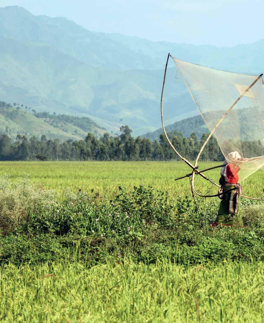
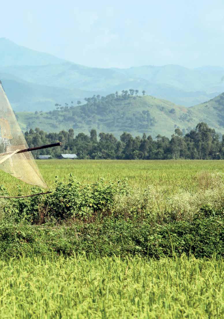
Of the nine districts in Manipur, five are located in the hills. A tribal population inhabits these districts, which are dominated by the Naga and the Kuki, as opposed to the valley which is a stronghold of the Meitei community. Rice farming in the hills is practised through jhum cultivation, while in the Imphal Valley, traditional farming methods are in practice.
away from geographical insularity. It then becomes critically important for all of us to understand not just ourselves, but the entire whole. On a larger canvas, the pieces and their interdependence become obvious. It is therefore imperative for us to know what all the pieces look like. Too often in the past, the links between these pieces were forgotten, or set aside deliberately.
Falguni Rajkumar, in his book Rainbow People, writes of Mera Haou Chogba, a festival celebrated in Manipur. Every evening, every Meitei household would light a lamp and raise it on a tall bamboo pole in the courtyard of their home. These lights, visible from the hills surrounding the Imphal Valley, were a signal from the younger brother (the Meitei) to the elder brother (the surrounding hill tribes) that they were safe and happy in their homes. With emerging technology, exciting schemes like the Kolodyne River Project form the bedrock of the Look East Policy that hopefully will lead to greater stability in the region.
In the Indian psyche, both Sikkim and North Bengal have been delinked from the Northeast. The remaining states that were carved out of Assam, along with Manipur and Tripura, are referred to as the Seven Sisters. This, however, defies geographical logic, for the Kanchenjunga massif, which has dominated the north-south Singalila Range since Sikkim became a part of India in 1972, marks the western extremity and separates the region from the rest of the subcontinent.
Therefore in today’s context, Sikkim, standing at the gateway to the Northeast, is our natural starting point in the book. Nye-
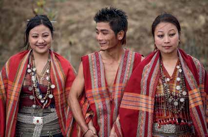
above | Mizo youth dressed in weaves of red, orange and black and decked out in traditional jewellery revel in song and dance.
centre | Come October, the Garo Hills begin to reverberate to the sound of drumbeats that announce to the world the start of Wangala, the most important festival of the Garo people. Offerings are made to honour Misi Saljong, the god of fertility who presides over crops and controls the rain, water and growth of all things. Music flows from flutes, gongs and buffalo-horns and the village gathers together for seven days and nights of dance, feasting, rice-beer drinking and revelry.
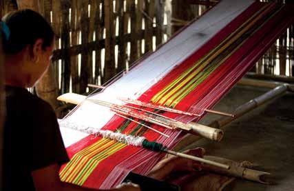
below | The loom goes clack-clack and a rich palette of colours emerges as the women weave, revealing time and time again the unerring aesthetic sense of tribal communities.
Mayelyang, or “a hidden heaven on earth”, was the name given by the Lepcha, who arrived at the base of “Khangchendzonga” in search of new lands in ancient times. The mountain, the guardian deity of Sikkim, dominates the northwestern part of a predominantly mountainous state. Sikkim shares its northern and northeastern borders with Tibet, and to the west and east are Nepal and Bhutan, respectively, while North Bengal’s Darjeeling District connects it to the rest of India. By the fifteenth century the Bhutia, along with Buddhism, arrived from Tibet, followed by the Nepalese and Hinduism a few centuries later. The glacierladen and wind-swept Sikkim Plateau, from where arises the Teesta River, lakes like the Khecheopalri and the Gurudongmar, the famous Nathu La and Jalep La passes, and a landscape dotted with monasteries—Dubdi, Rumtek, Tsuklakhang, Enchey, Sangachoeling and Tashiding among them—complete the picture of this erstwhile Himalayan kingdom. Recently, in a move that will hopefully help conserve the ecology of the region further, the Khangchendzonga National Park has been declared a World Heritage Site by the United Nations Educational, Scientific and Cultural Organization (UNESCO).
Darjeeling, along with the areas around Siliguri, Jalpaiguri and Cooch Behar, is linked by the Duars that connect us to Assam. This region remains one of the most spectacular in terms of natural beauty. The forests around Alipur Duar, namely, Jaldapara and the Buxa Tiger Reserve, have yielded some of the largest elephant specimens in recorded history.
To this day, the whole of the Northeast is just “Assam” to most people. Sitting at the heart of region, the state from which many of the other states were carved, Assam has international borders with Bhutan and Bangladesh and state borders with West Bengal, Arunachal Pradesh, Nagaland, Manipur, Mizoram, Tripura and
The Hojagiri dance of the Reang is performed with delicate balance and poise. Silver ornaments— particularly the distinctive coin necklace rangbauh, which also bestowes a high status—have pride of place in the women’s attire. Ethnic clashes and persecution by the Mizo forced the Reang to leave their homes in Mamit and Lunglei Districts. They continue to languish in camps in Tripura that have since claimed several lives.
Meghalaya. Hill tracts surround the low-lying Brahmaputra plains, the river entering the state at the northeastern end and flowing across it before entering Bangladesh at the southwest extreme. Assam, which derives its name from the Sanskrit word asoma, meaning “peerless and unparalleled”, has woven a rich fabric with its multi-ethnic composite culture, starting with the autochthon Bodo; the Ahom, who swept in from the eastern hills in the twelfth century and ruled for six centuries; the Tai Khampti; and, finally, the advent of British India, bringing in East Bengalis, Biharis and Oriyas. An agricultural state, Assam’s tea industry and the endless tea gardens have caught the imagination of the world.
From its western border with Bhutan to its eastern frontier with Myanmar, the Himalayan sweep of Arunachal Pradesh brackets the north for 1,030 km (640 mi.). A further stretch of 441 km (274 mi.), dipping southeastwards along the Naga Patkai Hills, rounds off this state at 83,743 sq km (32,333 mi.). It could well be defined as the eastern Land of Five Rivers, much like Punjab in the west. The five major river systems, namely, Kameng, Subansiri, Dibang, Siang and Lohit, along with their numerous streams and tributaries, complete the picture.
Historically, religion in Arunachal Pradesh can be seen in three parallel geographical layers—primarily Hinduism in the foothills in Upagiri; animism extending across the central belt, Antagiri; and Buddhism dominating the upper reaches of the Eastern Himalayas, Vahigiri. Today there is much more mobility, geographic and otherwise, seen amongst the different communities. Of the 110 tribes and sub-tribes, the Monpa, Sherdukpen and the Aka reside in the West Kameng District; the Nyishi, Tagin, Apatani and Hill Miri are to be found eastward in the Subansiri region; the Adi, Memba, Khamba and Mishing are astride the Siang; and the Mishmi, Khampti and Singpho are settled in the Lohit District. The Nocte and the Wancho make up the Tirap end.
The story of Nagaland the way the tribes recount it emerges from the ancient mists of time, handed down from generation to generation through oral traditions and from the accounts of those who helped open up this region. Among them, the works of Fürer-Haimendorf, James Philip Mills, Ursula B. Graham and Elwin reveal the multifaceted tribal world, which until recently was shrouded in a veil of inaccessibility. We observe the Angami, Ao, Konyak, Chang, Wokha, Sema, Lotha, Rengma, Chakhesang and many other tribes. Their clashes with the British as the latter tried to make inroads into the region are legendary. Then came Independence and the ensuing unrest that added to the further isolation of the region.
Manipur, which literally translates to "Jewel State", has a proud history with the Vaishnava dynasty of its Meitei community. It has a culturally rich pre-Hindu Sanamahi past, combined with a tradition of art and classical dance drama. While the Manipur Valley is Meitei-dominated, five of its nine districts are located in the hills and peopled by diverse Naga and Kuki tribes.
The Manipuri had taken on the British Raj headlong in 1890, but were eventually subdued by superior military force. The Kuki, in turn, continued to resist the British for the next fifty years, refusing to be subjugated. Post Independence, insurgency in Manipur began in the mid-1950s as an ideological movement for the restoration of the pre-British Meitei supremacy. The movement soon turned into an ethnic conflict, while the simultaneous growth of Naga militancy, with its close links to the Manipur Naga (mainly Tangkhul Naga), made it more of a political power struggle. Historically, the tribes—aligning, re-aligning, grouping and regrouping themselves in order to consolidate their own positions in the complex social hierarchy of the state—have dissipated a lot of energy. As a result, the common citizen often finds himself caught in the crossfire between the multiple underground organisations and security forces even today.
Mizoram literally means “Land of the Highlanders”. The first Mizo who settled in India were known as “Kuki” and subsequent immigrants were called “New Kuki”. The Mizo are believed to be Mongolian in origin and migrated into India from China. Topographically, the hills rise steeply, varying from 1,000 to 2,210 metres (3,279 to 7,248 ft.) (Phawngpui, or “the Blue Mountain”). Rivers cut deep gorges between the hills and flow either northwards or southwards. There are splendorous lakes with musical names like Palak, Tamdil, Rangdil and Rengdil. There is an attempt to unite all Mizo wherever they live. Tribes of several ethnic groups are linked either culturally or linguistically and form the Lushai/Lusei or Mizo, both umbrella terms bringing two-thirds of the populace together in today’s Mizoram. The Chakma, the Lai and the Mara are the other major tribes that mainly inhabit southern Mizoram.
Before descending back into the plains, on the southern flank of the Brahmaputra rise the Jaintia, Khasi and Garo Hills, which, like the Himalayan Range to their north, run east to west. Meghalaya literally means "Abode of Clouds". Geologists believe that this picturesque part of the country was, in fact, once a coral island
rising from the sea. The tribes that inhabit the plateau and valleys in these hills trace their origin to pre-Aryan times. The Khasi are Mon-Khmers, sharing a megalithic culture with the Jaintia, while the Garo are Tibeto-Burmese, of the Bodo group. Meghalaya was under the parallel rule of these three dominant tribes till the British gradually annexed it. This is the story of tribal life, where traditional structures like a matrilineal society, which have stood the test of time, coexist with Christianity and the urbanisation that gradually gained a foothold. It was only in 1972 that Meghalaya attained full statehood in the Union of India.
The Barak River Valley dominates southern Assam, which drops down from the Karbi region to Silchar, with the Naga Patkai to the east and the Jaintia Hills to the west. Partly owing to the low-lying terrain and the influence of the Barak waters, the region is a major “food basket”, with agriculture being one of the main occupations of the people. Historically, the entire link of southern Assam and the Barak River Valley has been exclusively through East Bengal. The Barak River enters the Karimganj District through its northeastern corner near Badarpurghat, after which it divides itself into two branches at Haritikar—the Surma and the Kushiara.
Finally, we come to the ancient land of Tripura that is tucked into the southwestern corner of the Northeast, bordered by Bangladesh to the west, by Assam to the north and south and then Mizoram to the east. Ruled from the eighth century till Independence by a single Kshatriya dynasty, it is believed to have ancestral links with the “Lunar” dynasty of the Mahabharata Tradition has it that Yayati’s son, Druhyu, came eastward and settled in Pragjyotishpura.
During Partition, a large chunk of Tripura, even though it was an independent kingdom, was ceded to East Pakistan (later Bangladesh) and thousands of immigrants flowed into the state that till then had majorly comprised its autochthons—the Dev Barman, Tripuri, Jamatia and the Reang, along with a few others. Thereafter, most of the tribal population was pushed up into the hills, and today the tribal populations form a small fraction of the state’s population. The kingdom of Tripura was one of the last princely states to join the Union of India, in 1949.
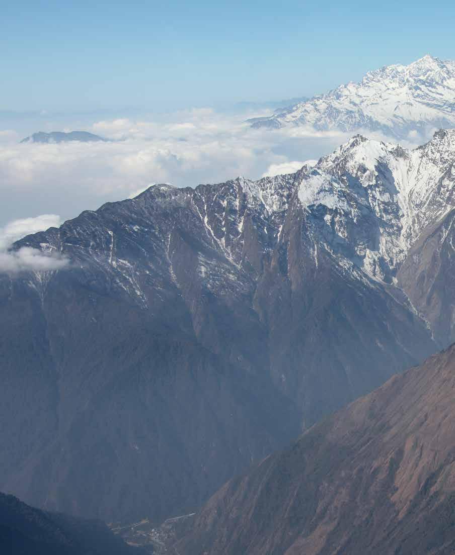
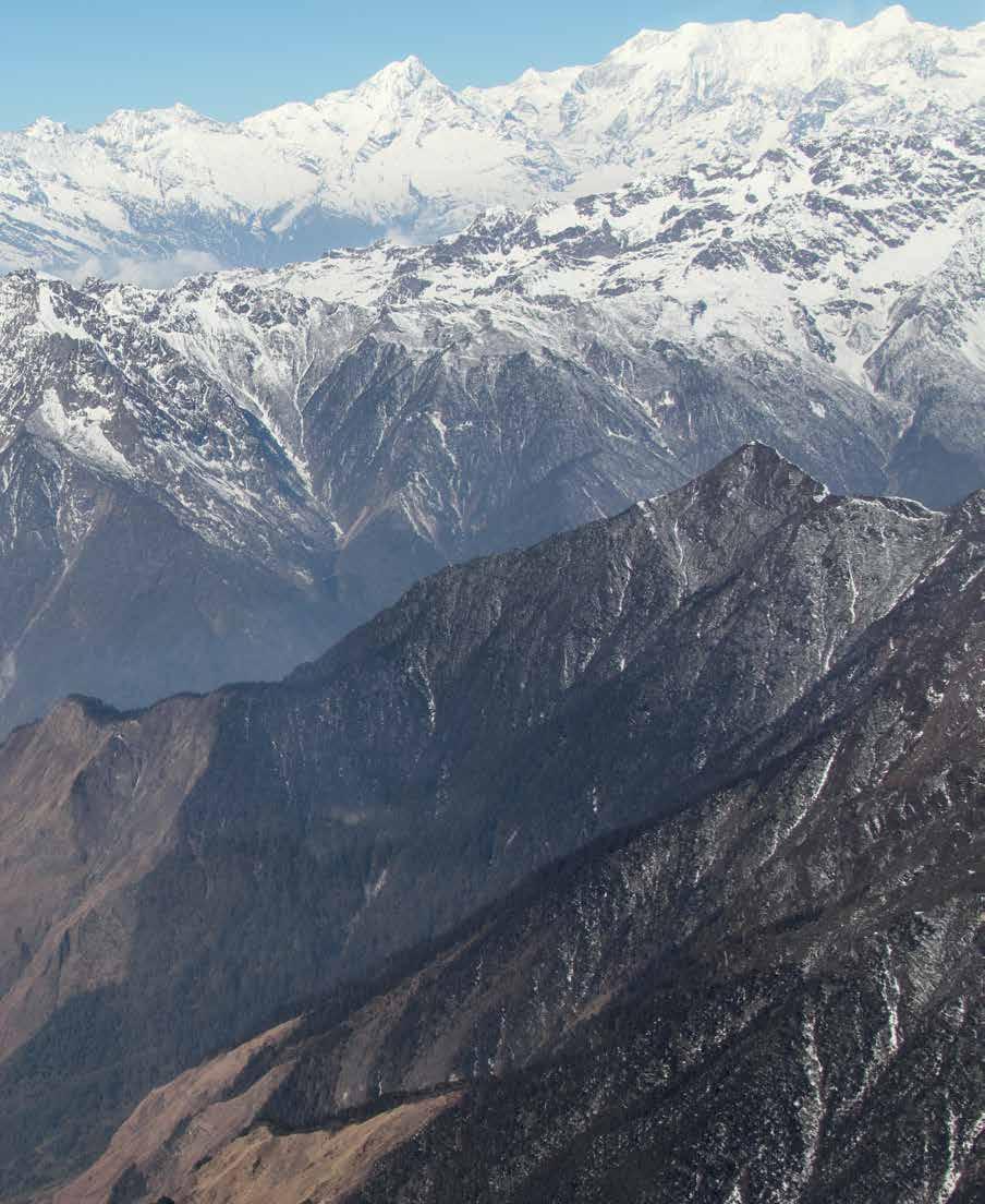
In a remote corner of India, tucked away in the Eastern Himalayas, a Bungthing invokes his gods. From the time the first settlers came to this hidden land, this is a scene that has often played out in the forest, since the Lepcha worship nature as the ultimate form of creation. Beyond the world’s third-highest mountain, Kanchenjunga, at 8,686 m (28,497 ft.), extend the great Assam Himalayas that stretch from Sikkim to Arunachal Pradesh. The Kanchenjunga massif, also known to the rest of the world as "the Mountain of Gold", dominates the Singalila Range and is revered by virtually all people, regardless of which faith they follow. If ever there was a landscape that inspires awe it is certainly this endless and formidable treasure of the Eastern Himalayas. In many ancient Hindu texts it is called Indrakil, or "the Garden of Lord Indra". During the annual Pang Lhabsol festival, the lamas of Pemayangtse Monastery in West Sikkim invoke the blessings of Khangchendzonga, Sikkim’s guardian deity, to protect the land and take care of the people.
The rugged and impassable Assam Himalayas throw out two equally enormous spurs—the Singalila Range that separates Sikkim from Nepal to its west and the Chola Range that divides the state from the Chumbi Valley and Bhutan to the east. These
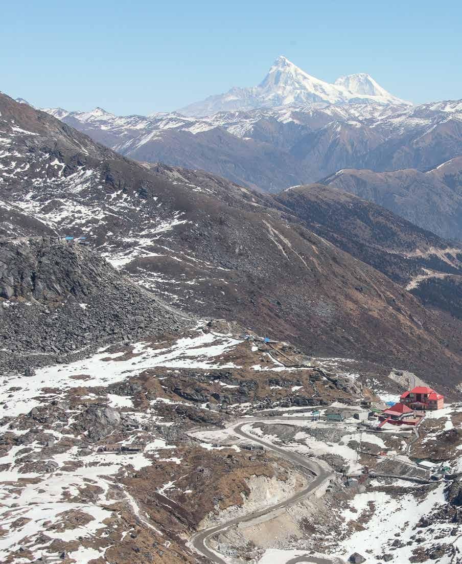
Nathu La, “the Listening Ears Pass”, at 4,310 m (14,140 ft.), a traditional part of the Old Silk Route, linked the plains of South Bengal to Lhasa in Tibet, traversing a distance of 563 km (349 mi.). Today manned by defence personnel, with no permanent human habitation and only an array of endangered species of animals for company, it opens for trade and visitors only during the summer months.
two mountain ranges form a gigantic amphitheatre, a maze of tangled interlacing ridges that rise range after range to the icy heights that are the perennial abode of the snows.
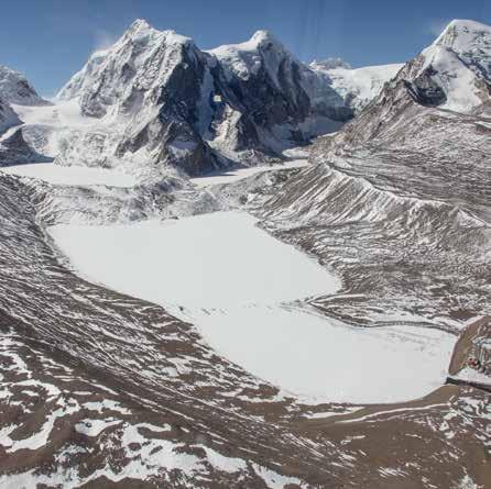
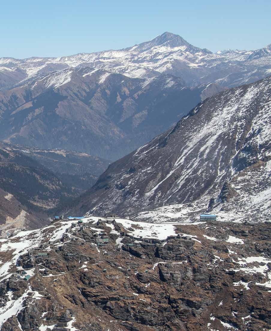
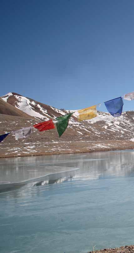
The Tibetan Plateau borders the North Sikkim Plateau, which, at an average altitude of 5,182 m (17,000 ft.), is home to some spectacular geographical features. The Kerang Bowl houses a glacier from where the Teesta River originates. Then there is the Gurudongmar Lake, which according to legend never completely freezes over, always leaving a small spot in the middle that is believed to be the blessing of revered saints like Guru Padmasambhava and Guru Nanak. This rain shadow area of the Kanchenjunga, a bleak and barren landscape given to extreme cold and blizzards, is even today the home of the nomadic herdsmen and their flocks of sheep intermingled with the shaggy yaks.
Moving eastward from Gangtok, past the Tsangu Lake, at an altitude of 4,310 m (14,140 ft.) lies Nathu La, one of the three traditional passes that connected Tibet and India. Even on a clear day, it is difficult to breathe here, and added to this is the wind chill factor. The pass was reopened after five decades for bilateral trade in 2006. Indian traders are allowed to set up shop a few kilometres inside China and, similarly, the Chinese can come down to Sherathang. Beyond lies the Chumbi Valley, where the boundaries of India, China and Bhutan meet.
Dipti Bhalla Verma, cofounder of the production company

KaleidoIndia, has made numerous films about the people, natural heritage and armed forces of India. She is also coauthor and photographer of the books Ocean to Sky: India from the Air, Tamil Nadu and the Northeast Trilogy. She is an alumna of Miranda House, Delhi, the Film and Television Institute of India, and the Australian Film and Television School.
Dipti Bhalla Verma • Shiv Kunal Verma
260pages,318photographs&12maps
9x11”(228.6x280mm),hc
ISBN:978-93-85360-25-1
₹2950|$55
Sept.2020•Worldrights
Shiv Kunal Verma is the author or coauthor of more than a dozen books, including the highly acclaimed Northeast Trilogy, The Long Road to Siachen and 1962: The War That Wasn’t. As the cofounder of KaleidoIndia, he has produced over fifty films. Among his many distinguished films on the Indian Armed Forces, The Standard Bearers, a film on the National Defence Academy, is considered an all-time classic. Educated at the Doon School and Madras Christian College, he currently holds the prestigious Chair of Excellence at the United Services Institute.

OTHER TITLES OF INTEREST
WATER TREASURES OF THE HIMALAYAS
Serge Verliat and Jean Philippe
MOULDING THE VOID Mother in the Making
Peter Bjørn Franceschi • with translations by Minati Kar
www.mapinpub.com