4 minute read
Artificial Intelligence
AL AIN MUNICIPALITY COLLABORATES WITH MBRSC TO ANALYSE PALM TREE COVER USING ARTIFICIAL INTELLIGENCE
THE COLLABORATION SUPPORTS THE UAE’S EFFORTS TOWARDS AGRICULTURAL PRODUCTIVITY
Advertisement
In line with the UAE’s efforts to increase agricultural productivity, the Mohammed Bin Rashid Space Centre (MBRSC) developed AI technology that helped detect 45,000 palm trees, in various regions of Al Ain. The project is within the framework of UAE’s approach to enhance cooperation between government entities to improve services and develop innovative solutions that are both cost and time saving.
MBRSC developed the AI technology to analyse the 10 centimetre-per-pixel resolution images provided by Al Ain Municipality by utilising in-house technology and experts from the Centre’s Application Development & Analysis Section. Through the AI system, MBRSC was able to detect 45,000 trees in less than a week, with an accuracy of 98.7%. With this technology, MBRSC was able to provide a solution to achieve an acceptable degree of accuracy to identify and extract very small objects using remote


Saeed AlMansoori, Head of Application Development & Analysis Section, MBRSC
Satellite image of palm trees
sensing technology, which would otherwise have taken months of work to achieve.
The project demonstrates the readiness and ability of Emirati competencies to employ remote sensing and artificial intelligence technologies to obtain innovative solutions that help the country achieve more with lesser time, money, and effort. It further reflects the spirit of cooperation between government agencies in the country and reinforces the principle of cooperation among them to improve service offerings in the UAE. The collaboration is also an example of how modern technology can assist in realising the UAE’s national agenda of ensuring sustainable development while preserving the environment and achieving a perfect balance between economic and social development.
Unique services
Saeed AlMansoori, Head of Application Development & Analysis Section, MBRSC, said: “Our strategy of combining the use of our high-resolution remote sensing capabilities with an evolving AI-driven analytics and delivery platform ensures that we offer some of the best services for environment monitoring and detection in the region with great accuracy.”
He added: “The delivery of AI technology for analysis and image processing for this project demonstrates our ability to leverage requests via next generation analytics architecture to deliver insights quickly and accurately. These services provided by MBRSC have been used for monitoring environmental changes, in addition to disaster relief efforts as artificial intelligence enables us to integrate information, analyse data, and use the resulting insights to improve decision making.”
In addition to helping UAE government entities with their projects and initiatives, MBRSC is also part of the International Disaster Charter and Sentinel Asia, playing a crucial role in disaster relief and management globally. Furthermore, the Centre’s geo analytics platform has contributed to providing potential solutions in terms of large area coverage, spatial and spectral information for government and private entities.
ARTIFICIAL INTELLIGENCE HELPING AFRICAN FARMERS IN THE FIGHT AGAINST LOCUSTS
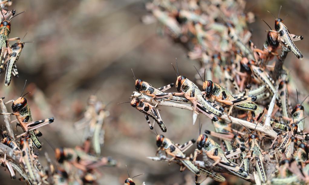
Afree tool that will help farmers and pastoralists across Africa to predict and control locust behaviour has been launched. Kuzi—the Swahili name for the wattled starling, a bird renowned for eating locusts—is an AI-powered tool that generates a real-time heatmap of locusts across Africa, shows all potential migration routes, and gives a real-time locust breeding index.
Using satellite data, soil sensor data, ground meteorological observation, and machine learning, Kuzi can predict the breeding, occurrence and migration routes of desert locusts across the horn of African and Eastern African countries, and uses deep learning to identify the formation of locust swarms. Kuzi then sends farmers and pastoralists free SMS alerts 2-3 months in advance of when locusts are highly likely to attack farms and livestock in their areas.
Without preventative measures, a swarm of 80 million locusts can consume food equivalent to that eaten by 35,000 people a day, devastating food stocks for vulnerable communities. Putting in place early detection and control measures, which are critical in desert locust management, will offer farmers and pastoralists a vital tool in the fight against world hunger and food insecurity.
Alerts are currently available for Ethiopia, Somalia, Kenya, and Uganda, in the regional languages of Kiswahili, Somali and Amharic, spoken by over 200 million people across Eastern Africa.
“The first international antilocust conference was held in Rome in 1931 and yet Africa continues to experience locust invasions almost 100 years later, with the worst locust invasion in 70 years occurring in 2020, threatening food supplies for millions of people across Eastern Africa. There has to be a better way to do this, one that has the local communities being central in the fight against locusts,” said John Oroko, CEO of Kuzi’s creator, Selina Wamucii.
“A new wave of locust upsurge now threatens millions across Eastern and Southern Africa, exacerbating food insecurity for already vulnerable communities, amidst the challenges of the COVID-19 pandemic. We have a responsibility to develop and deploy locally bred solutions that address these challenges faced by our vulnerable rural communities,” adds Oroko.
The free tool is currently available to users in Somali, Ethiopia, Kenya, and Uganda with plans to roll out to cover the rest of Africa.
Farmers can sign up for the free SMS alerts with any mobile device, with or without an internet connection, capture the GPS location of their farm, and they are good to go, without any charges.
For more information, visit www.selinawamucii.com/kuzi


