8 minute read
The West Coast Sea Breeze

from SoaringNZ Issue 11
by mccawmedia

By Paul Rockell
It is a part of the country most of us don’t know much about and its challenges are unique. As promised last month, this is the first of two stories on flying the sea breezes that form along the skinny piece of land at the top of the country.
Advertisement
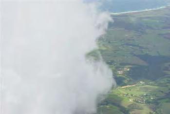
End of front near Whangarei Heads
Whangarei under the seabreeze
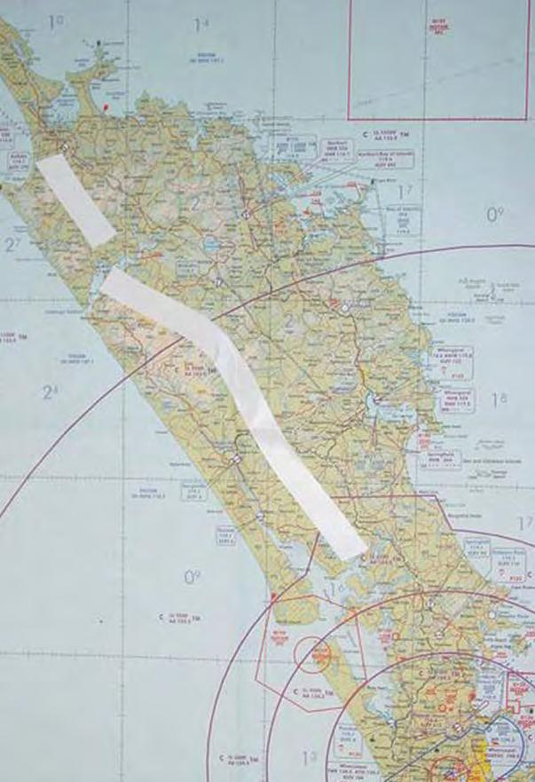
Map showing the usual position of the leading edge of the West Coast sea breeze front.
In the north of the North Island of New Zealand is a three hundred kilometre long peninsula. In essence this runs north to south and is only seventy kilometres at its widest. It rises high on basement greywacke to twelve hundred feet in the east and falls rapidly to the Pacific Ocean. The land to the west falls gradually to the Tasman Sea only interrupted by ancient volcanic remnants often joined over great distances by consolidated sand tombolos. Being subjected to high rainfalls and warm temperatures and never experiencing glaciations, most of Northland is characterised by eroding rolling hills either covered in native bush or exotic pinus radiata. The valley floors are intensively farmed, mostly dairying, but with fields quite large enough for landing gliders.
Most New Zealand glider pilots have little knowledge of what is available to gliding up here, no more than us Northlanders know anything about mountain peaks, snow and wave. This is a small account of some of the climatic features we are blessed with in this small area of New Zealand. Northland is quite uncluttered with air space regulations and in my view is a soaring paradise to those with the old pioneering spirit. Do not all come at once.
As the sun comes up on a summer’s day, I check the view towards the east coast. If the Northland peninsula is free of cloud with maybe a little valley mist but out at sea there are towering cumulus, that’s a sure sign the day is going to be a very soarable and more than likely involve sea breeze and convergence. On a good summer’s day in the north with our long coastlines and large harbours, there are myriads of sea breeze fronts and general convergences all with their differing cloud bases and characteristics to be explored. West Coast Sea Breeze
From mid December to mid March, when the ground has dried out sufficiently and the equinoctial winds are long gone: if the anticyclonic high pressure is centred on us or not too far south, the wind that day will favour us with a slight easterly breeze. All that day’s heat will flow towards the western side of Northland to meet the cool moist air sucked in off the Tasman Sea, producing one of our better sea breezes. Very occasionally this will run the length of Northland, over three hundred kilometres long. Most likely it is the original long white cloud of Aotearoa as seen from the first arriving canoes.
If the day heats up nicely, at midday I will take a peek over the homestead ridge to observe the cloud development in the interior. At about the same time the east coast sea breeze will be pulling back inland and overhead the dairy farms and airstrip where I live some fifteen kilometres from the sea. Gliders need to launch quickly at this time before the thermals move too far inland. For me, after a leisurely lunch, it is a simple matter of filling up a drink bottle, stowing fruit bars, rounding up Helen and any stray grandchildren and off to the DG400’s T hangar, pull out GNZ and go, usually getting
WEST COAST SEA BREEZE
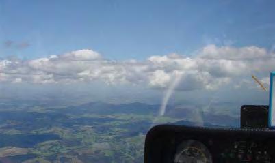
Paul Rockell in his glider

airborne at 2.30 pm. I am the afternoon’s light entertainment for those little farm kids who are well used to this noise and routine.
Takeoff is to the east and then I head west. Sometimes the east sea breeze has cleaned the thermals up to twenty kilometres back inland before they gradually strengthen with rising bases and then wham, we are in the business.
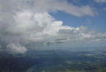
With our sea-scrubbed air and excellent visibility, the west coast sea breeze front can always be spotted from far away with its hanging walls of cloud, some thousand to fifteen hundred feet below the inland cloud base. Usually back some ten kilometres or more from the west coast beaches this cloud front can appear at times to be intermittent to the north and south with gaps. Sometimes there is lift along the frontal line with no observable cloud but most often it is well marked by wisps of condensing cloud getting sucked up into very blue-black bases. Most typically, a single length of cloud can be unbroken for up to twenty kilometres with very strong lift where, full negative flap, full speed, legs hugging the instrument console tightly and with the glider still climbing into the base, the only option is to peel out to the side, pull up, push on and dive back in. There is never any need for circling other than to admire a view or have a play with speeds rarely slower than 70 knots.
It is a special magic to fly this front northwards along the lee of the Tutumohe Plateau. This ancient volcanic basalt tableland rises between four to six hundred metres above sea level and extends about fifty kilometres in length, falling away rapidly on both sides like a smaller version of the Kaimai range in the Waikato. When the cool laminar sea air spills over the eastern side and meets the inland hot air it seems to create vortices of wave mixed with sea breeze with localised higher cloud bases. Behind the southern high point at Kaihu is the best place for this phenomenon.
Gliding gets more than a little surreal in these great roiling maelstroms a couple of kilometres wide, every bit of air is rising mixed up with pale mother-of-pearl coloured stringers of condensing cloud, nine-tenths closed in on all sides and with the malevolent dark green native bush base close beneath. Quite forbidding inside, glimpses out to brilliant afternoon sunshine and blue Tasman waters occur often enough to allow the pilot to stay orientated.
Paul Rockell has been soaring for nearly thirty years, mostly in the North.
He has logged around 1100 hours.
The northern extent of the front is usually cut off by the inflow of sea air into the Hokianga Harbour, so it mostly finishes between Opononi and Rawene Townships on the harbour’s edge. Sometimes, although rarely, it will start again quite strongly behind the high ground at Punguru on the north side of the harbour and run on towards Kaitaia.
I have never seen conditions yet where this cloud front continues up to Cape Reinga at the same time. It does happen rarely but it is mostly out of phase occurring earlier in the day with low bases and is then swept away. I once saw low level lenticulars over the length of North Cape peninsula over the top of low cumulus maybe set off by the beach dunes but I was standing on the ground. So, most times in the North Hokianga it will skew to be a convergence centred over the Maungamuka hills being affected by inflow over the Aupouri and Ranganunu Peninsulas to finish behind Kaeo Township in the east.
So pop out under the cloud, admire the giant sand dunes at the Hokianga harbour entrance and push on back south. Cloud bases in the north are usually between five and six thousand feet. Sometimes this front will act like a ridge and climbs can be made up the sides with an accompanying glory bow. Soar on and one hundred kilometres farther south is the largest harbour in the southern hemisphere, Kaipara Harbour. From the Northern Wairoa River south, cloud base usually lowers markedly to three thousand feet because of the flatter terrain and greater influence of harbour marine airs. However, if the front has merged into a single line convergence, flights all the way down the narrow part of the peninsula to Auckland are possible. Most often I turn back around Paparoa town, the length of good lift being over one hundred kilometres long, fly back to the high country south of Kaikohe and push out into cloudless sky, grit my teeth and head for home. With over three hundred kilometres of fantastic effortless flying and a great deal of fun with stunning scenic beauty I never tire of this Northland gliding classic.
When conditions are suitable, such as days with very cold air at height with a dash of tropical moisture laden air coming in at base, then this convergence can severely overdevelop with heavy rain in thunder storms – fantastic to look at if you are standing on the ground in the east and more than exciting if you are still soaring. Strong lift with great golden orbs of sunlit raindrops blowing off the tops just out from the edge with crash bang all around.
It is also possible to fly from the sea breeze front out to the west coast sand dunes where the wind off the sea is sufficiently strong to allow a flight up the beach to the Manganui Bluff which stands fifteen hundred feet high. Then ridge soar back up to two and a half thousand feet and head inland to the convergence again. There are so many interesting gliding scenarios still to be found up here and while Whangarei pilot Bernie Massey creeps off on the bleakest of days ridge-crawling for hours, all under 2500 feet, from coast to coast, declaring that he likes a technical challenge … just give me another hot summers day any time.


