
COMMUNITY LAND
PLAN OF MANAGEMENT

Version Control
Date
16/09/2021 Initial Draft (v0.1)
Comment
13/10/2021 Addition of Crowdy Head Reserves
10/11/2021 Amendments from Council staff review
22/11/2022 Addition of Tenure Details (v0.4)
24/02/2023 Addition of Pt 86532 (v0.5)
16/08/2023 Amendments following Department of Planning and Environment – Crown Lands (DPE-CL) Review. Update Environmental Planning Instruments (v0.6)
6/11/2023 Amendments following further DPE-CL Review. Update for existing tenures (v0.7)
11/12/2023 Amendments following further DPE-CL Review. Update for existing tenures (v0.8)
04/03/2024 Amendments following further DPHI-CL Review. Update for existing tenures (v0.9)
01/05/2024 Exhibition version (v1.0)
Plan of Management Report prepared by
Lands Advisory Services Pty Ltd PO Box 2317
Dangar NSW 2309
Email: enquiries@landsas.com.au
© Lands Advisory Services Pty Ltd 2021
Disclaimer:

Drawings, figures, analysis, forecasts and other details in this report have been prepared in good faith based on data and information supplied to Lands Advisory Services Pty Ltd by others. The data is believed to be correct at the time of publication of this report. However, it is noted that predictions, forecasts and calculations are subject to assumptions which may or may not turn out to be accurate. Lands Advisory Services Pty Ltd expressly disclaims all and any liability to any person or persons in reliance on the report and its contents in part or in whole.
Draft Community Land Plan of Management Page 2 of 199
Contents Version Control ............................................................................................................................2 Summary......................................................................................................................................6 1 Introduction......................................................................................................................7 1.1 A vision for community land ................................................................................................................... 8 1.2 The MidCoast Local Government Area 10 1.3 Legislative and Policy Context 12 1.3.1 Local Government Act 1993 12 1.3.2 Crown Land Management Act 2016 13 1.3.3 Native Title Act 1993................................................................................................................. 13 1.3.4 Biodiversity Conservation Act 2016 14 1.3.5 Local Land Services Act 14 1.3.6 Environmental Planning and Assessment Act 1979 14 1.3.7 Other Legislation and Statutory Controls 17 1.3.8 Additional Council Plans and Policies 17 1.4 Plans of Management ........................................................................................................................... 19 1.4.1 What is a Plan of Management? 19 1.4.2 Types of Plans 20 1.4.3 Relationship with Other Plans 21 1.4.4 Categorisation and Objectives 21 2 Community Land Plan of Management .....................................................................22 2.1 Land to Which this Plan Applies 22 2.2 Process for Preparing the Plan 22 2.3 Ownership and Management ............................................................................................................... 23 2.4 Land Categories..................................................................................................................................... 24 3 Leases, Licences, Authorisation and Other Estates...............................................25 3.1 Types of Tenures 26 3.1.1 Leases 26 3.1.2 Licences 26 3.1.3 Hire Agreements ....................................................................................................................... 26 3.1.4 Permits 26
Easements 26 3.2 Purposes for which Tenures may be issued 27 3.3 Tenures on Crown land and Native Title 28 3.4 Direction of Funds 28 4 Development ..................................................................................................................29 4.1 Development of New and Improvement of Existing Facilities.............................................................. 29 4.2 Community Engagement 30 5 Communication .............................................................................................................31 6 Park..................................................................................................................................32 6.1 Park Category Definition ....................................................................................................................... 32 6.2 Core Objectives - Park ........................................................................................................................... 32 6.3 Land included in the Park Category 32
3.1.5
Draft Community Land Plan of Management Page 4 of 199 6.4 Park Category Values 33 6.5 Key Management Issues for Parks 35 6.6 Desired Outcomes for Parks.................................................................................................................. 35 6.7 Permissible Uses and Development on Park lands ............................................................................... 36 6.8 Tenures on Park lands........................................................................................................................... 37 6.9 Performance Targets – Parks ................................................................................................................ 39 7 Sportsground.................................................................................................................42 7.1 Sportsground Category Definition 42 7.2 Sportsground Core Objectives .............................................................................................................. 42 7.3 Land included in the Sportsground Category........................................................................................ 43 7.4 Sportsground Values ............................................................................................................................. 43 7.5 Key Management Issues for Sportsgrounds 44 7.6 Desired Outcomes for Sportsgrounds 45 7.7 Permissible Uses and Development on Sportsgrounds 46 7.8 Tenures on Sportsgrounds 47 7.9 Performance Targets – Sportsground ................................................................................................... 49 8 General Community Use..............................................................................................53
General Community Use Category Definition 53 8.2 Core Objectives – General Community Use 53 8.3 Land included in the GCU Category 53 8.4 Values – General Community Use 54 8.5 Key Management Issues for GCU Land ................................................................................................. 55 8.6 Desired Outcomes for GCU Land .......................................................................................................... 55 8.7 Permissible Uses and Development on Land for General Community Use.......................................... 56 8.8 Tenures on General Community Use Lands 57 8.9 Performance Targets - General Community Use 61 9 Natural Area ...................................................................................................................63 9.1 Natural Area Category Definition.......................................................................................................... 63 9.2 Core Objectives – Natural Area............................................................................................................. 63 9.3 Values – Natural Area............................................................................................................................ 64 10 Natural Area Bushland .................................................................................................66 10.1 Bushland Category Definition 66 10.2 Core Objectives – Area of Bushland...................................................................................................... 66 10.3 Land included in the Bushland Category............................................................................................... 66 10.4 Key Management Issues of Bushland Lands ......................................................................................... 68 10.5 Desired Outcomes for Bushland Lands ................................................................................................. 68 10.6 Permissible Uses and Development on Bushland Lands 68 10.7 Tenures on Bushland Land 69 10.8 Performance Targets – Natural Area - Bushland 71 11 Natural Area Wetland....................................................................................................75 11.1 Wetland Category Definition ................................................................................................................ 75 11.2 Core Objectives – Area of Wetland....................................................................................................... 75 11.3 Land included in the Wetland Category 75 11.4 Key Management Issues for Wetland Lands 76 11.5 Desired Outcomes for Wetland Lands 77 11.6 Permissible Uses and Development on Wetland Lands........................................................................ 77 11.7 Tenures on Wetland Lands.................................................................................................................... 78 11.8 Performance Targets – Natural Area - Wetland.................................................................................... 79
8.1
Acknowledgement of Country
We acknowledge the traditional custodians of the land on which we work and live, the Gathang-speaking people and pay our respects to all Aboriginal and Torres Strait Islander people who now reside in the MidCoast Council area. We extend our respect to Elders past and present, and to all future cultural-knowledge holders
Draft Community Land Plan of Management Page 5 of 199 12 Natural Area Foreshore................................................................................................81 12.1 Foreshore Category Definition 81 12.2 Core Objectives – Foreshore Lands....................................................................................................... 81 12.3 Land included in the Foreshore Lands Category................................................................................... 81 12.4 Key Management Issues for Foreshore Lands ...................................................................................... 82 12.5 Desired Outcomes for Foreshore Lands 83 12.6 Permissible Uses and Development on Foreshore Lands 83 12.7 Tenures on Foreshore Lands 84 12.8 Performance Targets – Natural Area – Foreshore 86 13 Natural Area Watercourse ...........................................................................................88 13.1 Watercourse Category Definition ......................................................................................................... 88 13.2 Core Objectives – Watercourse Lands 88 13.3 Land included in the Watercourse Category 88 13.4 Key Management Issues for Watercourse Lands 89 13.5 Desired Outcomes for Watercourse Lands 89 13.6 Permissible Uses and Development on Watercourse Lands................................................................. 90 13.7 Tenures on Watercourse Lands ............................................................................................................ 90 13.8 Performance Targets – Natural Area - Watercourse ............................................................................ 92 14 Natural Area Escarpment.............................................................................................95 14.1 Escarpment Category Definition 95 14.2 Core Objectives – Escarpment Lands 95 14.3 Land included in the Escarpment Category .......................................................................................... 95 14.4 Key Management Issues for Escarpment Lands.................................................................................... 95 14.5 Desired Outcomes for Escarpment Land .............................................................................................. 96 14.6 Permissible Uses and Development on Escarpment Lands 97 14.7 Tenures on Escarpment Lands 98 14.8 Performance Targets – Natural Area – Escarpment 99 15 References ...................................................................................................................100 16 Appendices ..................................................................................................................101
Summary
This Community Land Plan of Management applies to the majority of land that is owned by MidCoast Council, and Crown land that Council manages on behalf of the State of New South Wales. All public land owned by a council must be classified as either “community” or “operational” land. The purpose of the land classification is to clearly delineate which land should be kept for use by the general public (community land) and which land need not be kept for that purpose (operational land).
A Plan of Management is required to be prepared for public land which is owned and/or managed by a council and classified as community land under the Local Government Act 1993, in acknowledgement of this land’s primary purpose – passive and active use by the community A Plan of Management on community land is a document that provides for and directs the use and management of that land. It describes the current purposes and uses of the community lands and their values, assigns them to one or more categories and sets out objectives and performance targets for active land management and use.
This Plan of Management (PoM) is a generic plan which covers land parcels across the MidCoast Local Government Area covering the Mid North Coast of NSW and its hinterland. These lands are categorised as Park, Sportsground, General Community Use and Natural Area, the latter of which is further categorised into Bushland, Wetland, Foreshore, Watercourse and Escarpment. The land covered by this plan was included in this plan because the generic management objectives and actions outlined in this plan are applicable to that land.
This PoM gives express authorisation for Council to grant leases, licences, hire arrangements or other estates as required for use of the land and/or facilities/buildings on the land, for purposes consistent with the core objectives for the category of that land. It also specifies the provisions whereby Council can carry out certain types of developments, and building works on community land, being either exempt development, or developments not requiring consent.
The vision for this Plan of Management for community land is:
“Continuing to provide great public facilities and services, while maintaining the culture, history, and natural qualities of the MidCoast for a prosperous and vibrant community”
Draft Community Land Plan of Management Page 6 of 199
1 Introduction
This PoM applies to parcels of land that are owned by MidCoast Council (Council) and classified as community land
This PoM also applies to Crown land that Council manages for the use of the general public. Crown land is owned by the State of New South Wales for the benefit of all persons. Local Government Authorities manage Crown land on behalf of the State, as Crown Land Managers, under Division 3.4 of the Crown Land Management Act 2016 (CLM Act) Council therefore now manages all community land, Crown or Council-owned, under one portfolio.
These land parcels are further categorised as Park, Sportsground, General Community Use and Natural Areas under the Local Government Act 1993 (LG Act).
The LG Act provides the legislative framework for Council’s day-to-day operations, and it identifies Council’s responsibility to actively manage land and to involve the community in developing a strategy for management.
This PoM has been prepared in order to achieve a balanced, responsible and ecologically sustainable use of the land and to ensure that it addresses the needs of the local neighbourhood, the broader community and the environment. It has been prepared to meet the requirements of the LG Act, as amended by the Local Government Amendment (Community Land Management) Act 1998.
Specifically, the aims of the PoM are to:
• update any previous plans of management for the community lands now covered in this PoM.
• meet Council’s obligations regarding public land management under the requirements of the LG Act and the CLM Act.
• provide a basis for guiding Council’s ongoing management of and developments on the community land covered by the PoM in accordance with relevant legislative requirements.
• contribute to the objectives of Council’s Community Strategic Plan1 and Local Strategic Planning Statement,2 its Regional Economic Development Strategy,3 and the Vision for community land development and management as highlighted in this PoM (see 1.1).
• reflect the values and expectations of the MidCoast community in the use and development of community land.
• utilise community contributions collected by Council in the development of the PoM to provide informed planning advice to Council
• facilitate desirable use of these land parcels by the community, through granting of appropriate leases, licences, permits and other estates.
1 MidCoast 2030: Shared Vision, Shared Responsibility 2018-2030: MidCoast Council (April 2018)
2 Local Strategic Planning Statement: MidCoast Council (September 2020)
3 Regional Economic Development Strategy 2018-2022 MidCoast Council
Draft Community Land Plan of Management Page 7 of 199
1.1 A vision for community land
A series of planning statements developed by Council build the directions for the future of the MidCoast Local Government Area which have particular relevance to the management of its community lands. Council’s own vision for the management of the MidCoast Local Government Area is:
“We deliver benefits for our community in a way that adds value and builds trust”
The statement reflects Council’s commitment to provide the appropriate level of services to the community, with a strong implication that this will occur through the sound management of all assets for which Council has responsibility, including its community lands.
Council’s Community Strategic Plan (CSP),4 its first community strategic plan developed from an extensive consultation process following the formation of the MidCoast Council (May 2016), outlines how working with the community will make this a reality. The community vision developed in this process is:
“... to be recognised as a place of unique environmental and cultural significance. Our strong community connection, coupled with our innovative development and growing economy, builds the quality of life we value”
The CSP includes five key values, for which a range of strategies are also provided:
• unique, diverse and culturally rich communities
• a connected community
• the environment
• a thriving and growing economy
• strong leadership and shared vision
Additionally, Council’s Local Strategic Planning Statement (LSPS)5 sets out the future for land use planning across the MidCoast that is based on those key values in the CSP. It outlines how growth and change will be managed to maintain the high levels of liveability, environmental amenity and rural character that the MidCoast is renowned for. The LSPS also reinforces that the unique characteristics that contribute to the local identity of our the Midcoast Local Government Area’s towns and villages should be maintained and enhanced:
4 MidCoast 2030: Shared Vision, Shared Responsibility 2018-2030: MidCoast Council (April 2018)
5 Local Strategic Planning Statement: MidCoast Council (September 2020)
Draft Community Land Plan of Management Page 8 of 199
• enhance liveability – people love where they live, feel safe and have a passion for retaining and enhancing local character, whilst seeking better access to services and facilities
• protect the natural environment – protecting our natural environment is important as it has strong links to liveability, tourism and economic growth
• increase economic opportunities – supporting local businesses and job creation are a high priority with the community.
• empower the community to shape its future – the community seeks improved information and involvement in decision making and long-term planning.
Further, Council’s Regional Economic Development Strategy (REDS)6 guides the development of the economic priorities, identifying three regional strengths which are built upon in the LSPS:
• land and water assets
• infrastructure and location
• lifestyle and amenity.
The vision of the REDS is that the MidCoast Local Government Area will:
“... have sustainable economic growth, founded on the Region’s natural assets, amenity and location, while offering a healthy lifestyle and community connection”
In summary, the main themes which recur with some emphasis within Council’s various planning statements are that:
• the involvement of the community in decision making about its own future
• the land base is critical in the achievement of the required services and lifestyle of a growing and vibrant community, and
• the substrata for delivering and receiving these services ranges from land and/or water based naturally occurring geographies which may also include and/or be associated with built infrastructure.
Indeed, a large proportion of the delivery of described services and outcomes will arise from the management of a vast and unique range of community lands by Council, with strong community involvement. This provides the foundations for this PoM and its prescribed directions.
Draft Community Land Plan of Management Page 9 of 199
6 MidCoast Regional Economic Development Strategy 2018-2022 MidCoast Council
The vision statement for the management of the community lands embraced by this PoM is therefore proposed as:
“
Continuing to provide great public facilities and services, while maintaining the culture, history, and natural qualities of the MidCoast for a prosperous and vibrant community”
1.2 The MidCoast Local Government Area
Occupying diverse landforms between the coast and the Great Dividing Range, the MidCoast Local Government Area is located approximately three hours drive north of Sydney and one and a half hours north of Newcastle via the Pacific Highway.

MidCoast Council was formed by NSW Government proclamation on Thursday 12 May 2016 through the merger of the former Great Lakes, Greater Taree and Gloucester Shire Councils (see Figure 1). It covers more than 10,000 square kilometers, and has a population of over 93,800 people, with:
• a medium age of 52 years.
Draft Community Land Plan of Management Page 10 of 199
Figure 1 – MidCoast Council Area
• 38.4% of the population aged 60 years plus.
• 20.7% under 20 years.
• 6.9% is identified as indigenous.7
The projected population growth rate of 0.3% per annum is expected to occur mainly in or near the region’s coastal towns and villages. Most population growth is likely to continue to occur in people over 60 years old, those seeking “sea change” or “tree change” from the Sydney Basin or Central Coast, making the MidCoast population one of the oldest in NSW.8 Key to the future management of community lands will be provision of facilities requiring a continued matching with new and emerging social and recreational needs of an ageing population.
Of the 196 towns, villages and localities that make up the MidCoast, each has its own character and identity, ranging from the historical charm of Gloucester through to the coastal setting of Seal Rocks. However, unique to the MidCoast, are two main population centres, Taree and Forster-Tuncurry 9 Taree offers a wide range of regional services and facilities that are utilised across the region, including the Manning Base Hospital, Taree Regional Airport, schools, sporting and entertainment facilities. Large tracts of industrial land also support a focus on industry.
In contrast, Forster-Tuncurry centres around lifestyle. Ideally located between the coast and lakes, both tourism and retirement living are important to the economy, leading to extensive shopping, entertainment and service facilities to support both residents and visitors.
The MidCoast Local Government Area is a significant, diverse and picturesque part of New South Wales, famous for its forests, waterways and beaches. Within the MidCoast Local Government Area, there is an emerging growth in nature and adventure-based tourism, taking advantage of its natural landscapes. The coastal experience attracts significant visitors over the summer months when the population swells with tourists coming to enjoy the region’s pristine coastline and beaches, coastal lakes, lagoons and other attractions. Some 2.2 million visitors enjoyed the MidCoast Local Government Area in 2018.
Relative to neighbouring coastal regions, the MidCoast region contains extensive waterways, coastal landscapes and diverse natural areas with high levels of biodiversity. However, habitat loss, degradation and fragmentation from clearing, introduction of invasive plants and animals, the impacts of climate change and catastrophic bushfires have pushed biodiversity and natural ecological systems into serious decline, undermining their uniqueness, quality, productivity and amenity value.10 Drought and flooding are also a serious consideration across the MidCoast Local Government Area, often impacting on the management regime of Council’s community lands.
This PoM covers a network of community land consisting of Crown Land and Council owned parcels across the MidCoast Local Government Area. This community land exists as parks, sporting fields, general community areas, and natural areas, all contributing to a range of essential services to the community.
7 The MidCoast is home to the Gathang speaking Aboriginal people, the Biripi and Worimi, a region rich in cultural pride and connection to the landscape and we embrace the spirit of reconciliation.
8 Local Strategic Planning Statement: MidCoast Council (September 2020)
9 Local Strategic Planning Statement: MidCoast Council (September 2020)
10 Local Strategic Planning Statement: MidCoast Council (September 2020)
Draft Community Land Plan of Management Page 11 of 199
Although not a complete description of purpose, these community land parcels deliver the following services and functional uses:
• memorial parks
• service club parks
• sport fields and courts
• resting places
• historically significant sites
• playgrounds and BBQ sites
• parks and gardens
• walkways
1.3
Legislative and Policy Context
1.3.1 Local Government Act 1993
• car parks
• caravan parks
• Rural Fire Service facilities
• community halls
• nature management areas including beaches, wetlands, watercourses, bushland and unique visual landscapes
Land owned by Council is managed under the Local Government Act (LG Act).
Part 2 of the LG Act provides that public land must be classified as either “community” or “operational” land. The purpose of the land classification is to clearly delineate which land should be kept for use by the general public (community land) and which land need not be kept for that purpose (operational land). The major consequence of the classification is that it determines the ease or difficulty by which the land may be alienated by sale, lease or other means. Community land would ordinarily comprise land such as a Sportsground, Hall, Public Park etc.,11 and Operational land would consist of land which facilitates carrying out of a public service, such as works depots, or land held as a temporary asset or investment.
Community land:
• cannot be sold
• cannot be leased, licensed or any other estate granted over the land for more than 30 years12
• must have a Plan of Management prepared for it.
The LG Act provides that community land must be categorised and specifies the core objectives for the management of each category.
The LG Act also provides for regulations which provide controls on the use and operation of land. Regulations which may impact the management of community land in the MidCoast Local Government Area include the Local Government (General) Regulation 2021 and Local Government (Manufactured Home Estates, Caravan Parks, Camping Grounds and Moveable Dwellings) Regulation 2021
11 See the note to Chapter 6, Part 2 of the Local Government Act 1993
12 Approval of the Minister administering the LG Act is required for leases over 21 years
Draft Community Land Plan of Management Page 12 of 199
1.3.2 Crown Land Management Act 2016
In New South Wales Crown land is managed under the CLM Act. However, Division 3.4 of the CLM Act provides that a council manager13 is authorised to classify and manage its dedicated or reserved Crown land as if it were public land within the meaning of the LGA 14
Crown land covered by this PoM (see Appendices 4 - 10) is owned by the State of New South Wales for the benefit of all persons.
The CLM Act requires councils to prepare plans of management for Crown reserves as if it were community land under the LG Act and the CLM Act.
Section 48 of the LG Act provides that Council has the control of certain Crown reserves for which it has not been appointed council manager. This land is not subject to the Division 3.4 of the CLM Act.
1.3.3 Native Title Act 1993
Native title describes the communal, group or individual bundle of rights and interests held by Aboriginal or Torres Strait Islander peoples. Matters relating to native title fall within the Commonwealth jurisdiction of the Commonwealth Native Title Act 1993 (NTA).
The NTA sets out how native title rights are to be recognised and protected, making provisions for Aboriginal and Torres Strait Islanders establishing the existence of native title, lodging native title claims, determining and validating the extinguishment of native title, and dealing with land and waters where native title may not have been extinguished.
On Crown land, Native title rights and interests must be considered unless native title has been extinguished, surrendered or determined by a court to no longer exist.
Dealings in land or water that affect (impair or extinguish) native title are referred to as ‘future acts’ and these acts must be done in compliance with the NTA. The NTA specifies procedures that must be followed before future acts can be done legally.
Some examples of acts which may affect native title on Crown land or Crown reserves managed by Council include:
• the construction of new buildings and other facilities such as toilet blocks, walking tracks, tennis courts, grandstands and barbecues.
• the construction of extensions to existing buildings.
• the construction of new roads or tracks
• installation of infrastructure such as powerlines, sewerage pipes, etc.
• the creation of an easement
• the issue of a lease or licence
• the undertaking of major earthworks.
13 A council manager is a local council which has been appointed Crown land manager of a reserve under Section 3.3 of the CLM Act
14 Section 3.22 of the CLM Act provides for certain restrictions on the management of Crown land relating to sale, classification and contravention of the CLM Act
Draft Community Land Plan of Management Page 13 of 199
On Crown land, a future act undertaken by Council, which is not covered by one of the Future Act subdivisions of the NTA will be invalid
1.3.4 Biodiversity Conservation Act 2016
The Biodiversity Conservation Act 2016 (BCA) establishes the legislative framework for the conservation of threatened species, populations and ecological communities of plants and animals in NSW. It also aims to improve the identification, conservation and recovery of threatened species and reduce the threats faced by those species. The LG Act requires that where community land is associated with the habitat of endangered species (s 36A) or threatened species (s 36B), appropriate responses are required where a plan of management is being considered, including considerations being subject to the decision of respective department heads.
1.3.5 Local Land Services Act
The objects of the Local Land Services Act 2013 (LLSA) broadly include that the management of natural resources occur in the social, economic and environmental interests of the state (s 3). Pertinent to land management actions on community land, Part 5A regulates the clearing of native vegetation. The LLSA applies to rural lands, with the exception of those for which restrictions on the clearing of native vegetation otherwise apply (Wilderness Act 1987, National Parks and Wildlife Act 1974, Forestry Act 2012, Biodiversity Conservation Act 2016, and more) However, clearing which is to be assessed under Part 5 of the Environmental Planning and Assessment Act 1979 (which covers the majority of local government activities), does not require consideration under the LLSA.
The consideration for clearing of native vegetation on non-rural areas of NSW is included within the State Environmental Planning Policy (Vegetation in Non-Rural Areas) 2017,15 and also considered within the Biodiversity Conservation Act 2016.
1.3.6 Environmental Planning and Assessment Act 1979
The Environmental Planning and Assessment Act 1979 (EP&AA) provides the overarching control of planning and development in NSW. The EP&AA creates three levels of Environmental Planning Instruments being:
• State Environmental Planning Policies
• Local Environmental Plans, and
• Development Control Plans.
The EP&AA is the enabling legislation for many of the roles and responsibilities of local governments in NSW. Under Division 3.4 (3) (b) councils are authorised to make Local Environment Plans (LEPs). Division 4.2 ensures a council has the power of a consent authority for nominated developments within the local area over which the council has jurisdiction Both these authorisations permit councils to implement and manage any PoM on community land as required by the LGA.
In the MidCoast Local Government Area, the Environmental Planning Instruments with significant impact on the management of community land are the State Environmental Planning Policy (Transport and Infrastructure) 2021 (T&I SEPP), the respective Local Environment Plans of the three former constituent Local Government Areas, and their Regional Development Control Plans.
15 Part 1 S. (1) (b) of the State Environmental Planning Policy (Vegetation in Non-Rural Areas) 2017.
Draft Community Land Plan of Management Page 14 of 199
State Environmental Planning Policies
Community land is subject to a range of State Environmental Planning Policies.
Of particular note is the T&I SEPP Section 2.73 of the T&I SEPP provides that development for any purpose may be carried out without consent on Crown managed land, by or on behalf of a Crown land manager of the land if the development is for the purposes of implementing a plan of management adopted for the land in accordance with the LGA 16
Other State Environmental Planning Policies that are considered more relevant to the future of the community land covered by this PoM are briefly described in Appendix 1 being:
• State Environmental Planning Policy (Exempt and Complying Development Codes) 2008
• State Environmental Planning Policy (Primary Production and Rural Development) 2021
• State Environmental Planning Policy (Biodiversity and Conservation) 2021
• State Environmental Planning Policy (Housing) 2021
• State Environmental Planning Policy (Resilience and Hazards) 2021
• State Environmental Planning Policy (Industry and Employment) 2021
• State Environmental Planning Policy (Resources & Energy) 2021
Land Zones
Due to the relatively recent formation of the MidCoast Council, Local Environmental Plans (LEP)s from three constituent Councils remain jurisdictional and transitional:
• Greater Taree LEP 2010
• Great Lakes LEP 2014
• Gloucester LEP 2010
The respective LEPs provide Land Zones for all land within the MidCoast Local Government Area
The zoning of these areas across the existing LEPs are currently being reviewed as part of preparing a new LEP for MidCoast Local Government Area, to best reflect the most common and appropriate purposes of community land.
A full list of the described zonings applicable to the lands of this PoM, and their respective permitted and prohibited activities in accordance with corresponding Land Use Tables, as they now apply, can be found within Part 2 in each of the respective LEPs 17
Further LEP Considerations
The LEP zonings also requires important planning considerations and requirements, triggering additional state legislative responsibilities. These appear in the respective LEPs (Great Lakes, Greater Taree and Gloucester) as listings of various Miscellaneous provisions
16 Appendix 2 has a brief description of the ISEPP.
17 The PoM refers to permitted uses within the LEPs as being permitted uses on community lands, however, the ISEPP provides that development for any purpose may be carried out without consent on Crown managed land, by or on behalf of a Crown land manager of the land if the development is for the purposes of implementing a plan of management adopted for the land in accordance with the LGA.
Draft Community Land Plan of Management Page 15 of 199
and Schedules, and relevant map indices. The following are examples where these requirements will have likely implications to the management of some of the land parcels considered within this PoM:
• Part 5 (Great Lakes, Greater Taree, Gloucester):
o Heritage Conservation
o Bushfire Hazard Reduction
o Infrastructure Development
o Eco Tourist Facilities
• Part 7 (Greater Taree, Great Lakes)
o Acid Sulfate Soils
o Coastal Risk Planning
o Riparian Land and Watercourses
o Wetlands
o Protection of Wildlife Corridors
o Limited Development of Foreshores
• Schedule 5 (Gloucester) and Schedule 6 (Greater Taree, Great Lakes)
o Environmental Heritage
Draft Community Land Plan of Management Page 16 of 199
1.3.7 Other Legislation and Statutory Controls
A PoM does not over-rule additional legislation and statutory controls that also apply to the management of community land.
1.3.8 Additional Council Plans and Policies
In addition to the above state policies and the directions of the LEPs, Council has developed a number of plans, strategies, general policies and papers which have either direct or broad relevance to planning, management and maintenance of community land. The following lists those of particular relevance for the future management and service delivery of the land parcels covered by this PoM:
• Community Strategic Plan - Council has developed MidCoast 2030: Shared Vision, Shared Responsibility to be the guiding document for our community. As the first Community Strategic Plan for the region, this plan plays a critical role in providing the framework which will set the direction for many activities, programs and projects over the coming years.
• Local Strategic Planning Statement - sets out a future vision for land use planning across the region. The Statement outlines how growth and change covered in the Community Strategic Plan will be managed to maintain the high levels of liveability, environmental amenity and rural character. It also reinforces that the unique characteristics that contribute to the local identity of our towns and villages should be maintained and enhanced.
• Engagement and Communications Strategy 2030 - developed in conjunction with the Community Strategic Plan, recognises that strong and effective communication can deliver a range of benefits, including strengthening relationships, generating support and participation and improving community awareness of programs, activities and services. This strategy provides for a greater understanding of the role and responsibilities of Council and the community in delivering the Community Strategic Plan.
• Community Engagement Strategy 2019-2022 - The Community Engagement Strategy sets Council’s commitment to engaging with the community not only to support decision making and plan for community projects, but to also build relationships and strengthen communities. The strategy acknowledges the enthusiasm of the community as being an important consideration in the management and use of community land. It provides an engagement toolkit for the process of community engagement.
• MidCoast Destination Management Plan - enables a vibrant community to grow the visitor economy through addressing both supply and demand. It acknowledges that tourism and the growth of the visitor economy is everyone’s responsibility. Visitations impact on the use of community land.
• Regional Economic Development Strategy (REDS) - is linked with Council's Community Strategic Plan and Destination Management Plan, and provides a strategic platform for community, business and Council to work with the State Government in driving economic growth. It is an important plan that will help attract State resources to underpin economic projects and create employment in the region.
• MidCoast Cultural Plan 2036 - the MidCoast is home to a diverse number of communities, each having their own unique story. Yet from freshwater to saltwater, bush to beach, the region also shares a strong sense of belonging, community and history. The plan emphasises identifying how the community can come together to celebrate its unique story.
Draft Community Land Plan of Management Page 17 of 199
• Climate Change Strategy - sets out the case for a range of cost-effective actions that can be implemented progressively over several years to reduce Council’s carbon emissions and adapt its operations to the impacts of climate change. These actions include investing in renewable energy, becoming more energy efficient, sequestering carbon, transitioning to more sustainable transport options and reducing our waste to landfill. Climate change impacts on the use of community lands (bushfire hazard and management, sea level rise and storm surge etc.). Further, in acknowledging that a state of climate emergency currently exists, Council has affirmed that urgent action is required by all levels of government to take clear steps to avert a climate crisis. Anticipated impacts from climate change include: an increase in the number of extreme hot weather days and bushfire risk; sea level rise resulting in inundation of low-lying areas, wave over-topping and accelerated coastal erosion; and an increase in the frequency of storm events, intense rain periods and flooding 18
• MidCoast Greening Strategy – As the region experiences growth, especially in the coastal centres, it is important to ensure that the high levels of liveability and renowned environmental amenity are maintained. The aim of the MidCoast Greening Strategy is to manage and enhance the quality and extent of vegetation across our diverse landscapes.
• MidCoast Vegetation Management Policy – provides the process to issue permits for the pruning or removal of tree(s) or vegetation on private land, based on a consideration of defined assessment criteria.
• MidCoast Biodiversity Framework 2021-2030 – provides directions for Midcoast Council and the community to manage the rich natural heritage found across the MidCoast Local Government Area.
• MidCoast Manning River Estuary Catchment and Management Program 20212031 – prepared, as required by the Coastal Management Act 2016 This program identifies issues and actions that address the needs of whole-of-catchment fresh and salt water systems, including upstream impacts on the estuary and marine waters.
• Local Community Plans (various) – have been developed with the communities of Coolongolook, Wang Wauk and Wallingat Rivers Catchment Committees, Nabiac, Wootton, Coomba and more
• Coastal Wetland and Littoral Rainforest maps – have been produced as a requirement of the State Environmental Planning Policy (Coastal Management) 2018 These maps cover some of the reserves impacted by this PoM.
• MidCoast Pedestrian Access and Mobility Plan 2021 (updated) – MidCoast Council is committed to developing pedestrian access, accessible footpaths, shared pathways, cycleways, bike facilities and community pedestrian bike and cycle systems to ensure effective links for the community.
• MidCoast Council’s Development Contribution Plans – Collects funds for improvements to the open space network of reserves which fall under Council’s jurisdiction
Full details of Council’s relevant policies and plans as listed above can be found at Council’s website at www.midcoast.nsw.gov.au/council/Plans-and-reports
18 MidCoast Greening Strategy 2021
Draft Community Land Plan of Management Page 18 of 199
1.4 Plans of Management
1.4.1
What is a Plan of Management?
The LG Act requires that Council prepare a plan of management in conjunction with the community to identify the important features of the land, clarify how Council will manage the land and how the land may be used or developed Until a plan of management for community land is adopted, the nature and use of the land cannot be changed. To change the nature and use of the land, the plan of management must be revised.

Council will undertake the required process as per Section 36 of the LG Act and Section 3.23 of the CLM Act for this plan of management (PoM)
Specifically, S. 36 (3) (a)-(d) of the LG Act requires that a plan of management must identify:
• category of the land (see 1.4.4).
• objectives and performance targets of the Plan with respect to the land (see 1.4.4).
• means by which the Council proposes to achieve the PoM's objectives and performance targets.
• the manner in which Council proposes to assess its performance with respect to the Plan’s objectives and performance targets.
A plan of management may give authorisation for Council to grant leases, licences, hire arrangements or other estates as required for use of the land and/or facilities/buildings on the land in compliance with S. 46 of the LG Act for purposes consistent with the core objectives for the category of land.
Draft Community Land Plan of Management Page 19 of 199
1.4.2 Types of
Plans
The LG Act allows a plan of management to cover one or multiple parcels of land.
Where multiple parcels of land are covered in one plan (Generic Plans), like this plan, the LG Act specifically states what needs to be included. Where a plan of management covers one parcel of land (Specific Plans), there is greater detail on what has to be prescribed in the Plan. A Generic Plan sets the framework of how the land is to be managed. A Specific Plan clearly outlines very precise management proposals.
Plans of management for community land are periodically reviewed to enable changing social, economic and ecological conditions to be taken into account and consequent amendments to the Plan may occur.
For the majority of lands considered here, this PoM is the first to be developed. Note that Generic plans that applied to the land cease to apply once land is affected by threatened species laws. In this circumstance, a new specific PoM must be prepared that complies with the requirements. No change in the use of the land and no new lease or licence can be granted until the required specific PoM is made 19
Specific works to be carried out in individual Parks, Sportsgrounds, General Community Use and Natural Area land will be shown on masterplans and various schedules to which this PoM refers, which will be prepared in the future as required and which will include engagement with the community.
19 Public Land Management Practice Note No.1 (revised) May 2000: NSW Department of Local Government
Draft Community Land Plan of Management Page 20 of 199
1.4.3 Relationship with Other Plans
This PoM provides an overarching strategy and consistent management approach for community land parcels within the MidCoast Local Government Area, with the exception of those lands for which specific plans of management have been developed or are to be developed and for which this Generic plan has no jurisdiction. It is currently proposed by Council that specific plans of management will be developed for the following community land:
• Andrews Reserve
• Bulahdelah Showground
• Cedar Party Creek
• Forster Foreshore
• Gloucester / Billabong
• Harrington Foreshore
• Nabiac Showground
• Part North Tuncurry Sports Complex
1.4.4 Categorisation and Objectives
• Old Bar Park
• Stroud Showground
• Taree CBD Foreshore
• Taree Regional Recreation Centre
• Wingham Foreshore
• Wingham Sporting Complex
• Wrigley Park
• Southern Wallis Foreshore Management Plan
Under Section 36(4) of the LGA, all community land must be categorised as one of the following categories:
• Natural Area - further categorised as either Bushland, Wetland, Escarpment, Foreshore or Watercourse
• Sportsground
• Park
• Area of Cultural Significance;20 or
• General Community Use.
The Core Objectives for all community land categories vary according to the categorisation of the land. All objectives for all categories are defined in Sections 36E to 36N of the LG Act and also appear in Appendix 3 of this PoM
20 Note that land that is the subject of a resolution by the Council that declares that where items of Aboriginal, historical or cultural significance are present, the land is an area of cultural significance. In these cases, the land cannot be dealt with under a generic plan and must have its own specific plan of management.
Draft Community Land Plan of Management Page 21 of 199
2 Community Land Plan of Management
2.1 Land to Which this Plan Applies
Thelands whicharesubjectto thisPoMaredistributedacross the MidCoast Local Government Area. There is a natural concentration of land parcels within and around the major centres of Taree and Foster-Tuncurry however they also exist within and between smaller towns and villages (Bulahdelah, Gloucester, Harrington, Hawks Nest, Old Bar and Wingham etc.) and generally amongst rural communities.
The parcels included were generated from Council’s Land Register of all public land areas listed in Appendices 3 to 10
2.2 Process for Preparing the Plan
The process for the development of this PoM involved the following steps:
• inception meeting with Council staff
• supply of relevant community land title information from Council, including LEP zonings and ownership (Crown, Council)
• preliminary categorisation of Crown land sent to the Minister for approval
• PoM drafted and discussed with Council.
• in accordance with Section 70B of the Crown Land Management Regulation 2018 Council will obtain consent of the Minister administering the CLM Act prior to adopting this MSPoM (see Appendix 13).
• public notification of the preparation of the draft PoM on Council’s website.
• draft PoM on exhibition on Council’s website, at libraries and customer service areas
• written submissions received online to Council
• public hearing into proposed categorisation and recategorisation of community land or if the boundary of a categorisation within a category of community land changes, as required
• review and advice from Council’s Native Title Manager and notification to Native Title claimants and /or NTSCORP (if required).
• resolution by Council.
• adoption by the Minister required only if significant changes made to draft regarding Crown land.
Community consultation is an important process providing information necessary for an effective PoM for community land and is a requirement under Section 38 of the LGA. As such, Council is committed to the principles and activities within the participating community which guide Council’s decision-making processes. Such participation creates the opportunity for interested parties to become actively involved in the development of a plan which reflects the needs, opinions and priorities of people using such community lands
Draft Community Land Plan of Management Page 22 of 199
Many discussions were conducted between the authors of this PoM and Council officers during its compilation. Council will undertake further consultation as necessary, in accordance with its communication strategies
2.3 Ownership and Management
The majority of the community land to which this PoM applies, is owned by:
• MidCoast Council
• the State of New South Wales21 being Crown land.
There are also a number of parcels owned by other government agencies and by private land holders which are included in this PoM. Council has met the requirements of Section 39 of the LG Act in regards this land.
Appendices 3 - 10 show ownership details of the land subject to the PoM.
Much of the Crown land is subject to native title rights and interests under the NTA (see Section 1.3.3 of this PoM). On Crown land native title rights and interests must be considered unless:
• Native title has been extinguished; or
• Native title has been surrendered; or
• determined by a court to no longer exist.
Aboriginal Land Rights
The Aboriginal Land Rights Act 1983 (ALRA) seeks to compensate Aboriginal peoples for past dispossession, dislocation and loss of land in NSW. The lodgment of an aboriginal land claim (ALC) under Section 36 of the ALRA, over Crown land creates an inchoate interest in the land for the claimant pending determination of the claim. The Department of Planning, Housing and Infrastructure – Crown Lands (DPHI-CL) advises that, if the land is subject to an undetermined ALC, any works, development or tenures authorised by the PoM should not go ahead if:
• the proposed activity could prevent the land being transferred to an ALC claimant in the event that an undetermined claim is granted
• the proposed activity could impact or change the physical/environmental condition of the land, unless:
o the council manager has obtained written consent from the claimant Aboriginal Land Council to carry out the proposed work or activity, and/or
o the council manager has obtained a written statement from the Aboriginal Land Council confirming that the subject land is withdrawn (in whole or partial) from the land claim
• the proposed activity is a lease to be registered on title unless the council manager has obtained written consent from the claimant Aboriginal Land Council
21 Council is Crown land manager for Crown land subject to this PoM
Draft Community Land Plan of Management Page 23 of 199
Some of the Crown land in this PoM will be subject to ALCs. These ALCs claims await determination by the Minister for Lands and Property Any land granted under ALRA will no longer be subject to this PoM.
Most community land subject to this PoM will be managed directly by Council. However, where appropriate, council may establish committees under Section 355 of the LG Act to advise and assist with the management of specific facilities.
2.4 Land Categories
In accordance with the guidelines set out in the Local Government (General) Regulation 2021 and Practice Note 1: Public Land Management (Department of Local Government Amended 2000), and consistent with respective core objectives, all community land reserves covered by this PoM are categorised either as:
• Park - Appendix 3 lists the land parcels categorised as Park.
• Sportsground - Appendix 4 lists the land parcels categorised as Sportsground.
• General Community Use - Appendix 5 lists the land parcels categorised as General Community Use.
• Natural Area, and its further categories Bushland, Wetland, Watercourse, Foreshore and Escarpment – Appendices 6-10
For Crown land these categories have been assigned as required under Section 3.23 of the CLM Act.
Draft Community Land Plan of Management Page 24 of 199
3 Leases, Licences, Authorisation and Other Estates
For this section, please see the Explanation of Terms22 set out below.
Council may allow use of community land by a casual user for any permissible use (see sections 6 – 14) according to the land category. However, Council may require a form of authorisation for a permissible use to be undertaken.
The authorisation in a POM gives ‘in principle’ support for activities, uses and developments consistent with the objectives for land categorisation to proceed to development assessment under the Environmental Planning and Assessment Act 1979, if required.
This POM does not in itself imply or grant consent for activities, uses or developments. Any proposed uses and developments which are consistent with this POM must still be referred for development consent and where required, be advertised widely for information and invitation to comment. Any subsequent application for development consent would be supported by and assessed against this POM.
The LG Act provides that tenures (leases, licences, or any other estates) or easements may be granted over all or part of community land in accordance with Section 46.
Tenures may be held by:
• community organisations and sporting clubs, or
• by private/commercial organisations or
• individuals providing facilities and/or services for public use.
The maximum period for leases and licences on community land allowable under the LG Act is 30 years (with the consent of the Minister for a period over 21 years) for purposes consistent with the categorisation and core objectives of the particular area of community land.
Community land may only be leased or licensed for periods of more than 5 years if public notice is given according to the requirements of Sections 47 and 47A of the LG Act
On Crown land which Council manages under Section 48 of the LG Act, Council does not have authority to issue tenures. For these lands tenures must be issued by the Minister administering the CLM Act.
22 Explanation of Terms
Tenure A lease, licence or other estate issued by Council in accordance with Section 46 of the Local Government Act 1993 or Section 2.20 of the Crown Land Management Act 2016.
Hire Agreement An estate issued by Council generally for the single use of a facility.
Holder The company, organisation, individual or group of individuals who have been issued with a Tenure.
Hirer The company, organisation, individual or group of individuals who have been issued with a Hire Agreement.
Regular Hirer A Hirer who regularly uses a facility through a Hire Agreement or has an ongoing Hire Agreement.
Singular Hirer A Hirer who has a Hire Agreement as a once off or irregularly.
Casual User A person or group of people using community land for passive recreation, non-commercial purposes without a Tenure or Permit
User The collective term for a Holder, Hirer and Casual User.
Permit A permit is an authority to undertake a use which may or may not attract a fee.
Draft Community Land Plan of Management Page 25 of 199
3.1 Types of Tenures
3.1.1
Leases
A lease will be generally required where exclusive use or control of all or part of community land is desirable for effective management. A lease may also be required when the scale of investment in facilities, the necessity for security measures, or where the relationship between a holder and facilities on community land justifies such security of tenure.
Leases issued by Council will require:
• That subleases or any other supplementary tenures can only be issued by the Holders with the approval of Council, and consistent with Section 47C of the LGA.
• Maintenance of the facility will be the responsibility of the Lessees.
3.1.2
Licences
Licences allow multiple and non-exclusive use of an area. A licence may be required where intermittent or short-term use or control of all or part of the community land is proposed. A number of licences for different holders can apply to the same area at the same time, provided there is no conflict of interest.
3.1.3
Hire Agreements
An agreement for use of community land (Hire Agreement) may be issued by Council for any purpose listed in Sections 6-14, or by a Management Committee subject to the approval of Council. A hire agreement may be issued to a regular hirer or a singular hirer for formal use. Any legal requirements as determined by Council will include the requirement for adequate public liability insurance cover. Hire agreements may be issued for the use of a hall or a tennis court, etc
3.1.4
Permits
A permit may be issued by Council to undertake a particular activity on community land. Such a permit may or may not attract a fee.
3.1.5
Easements
Council reserves the right to grant easements as required for utilities and access, bearing in mind the impact of such easements on the site.
The granting of easements over Crown land will be subject to the provisions of the Native Title Act 1993 and Division 8.7 of the Crown Land Management Act 2016.
Draft Community Land Plan of Management Page 26 of 199
3.2 Purposes for which Tenures may be issued
In accordance with Section 46A of the LGA, a Plan of Management for community land is to specify and authorise any purpose for which a lease, licence or other estate may be granted over community land during the life of a Plan of Management.
This Plan of Management authorises a Tenure to be issued:
• for any permissible use (see Sections 6 – 14)
• for purposes consistent with the designated:
o categorisation, and
o zoning under Section 46 of the LGA, and
o on Crown land, the reserve purpose of the particular reserve (see Appendix 11) as required under the CLM Act
• on Crown land, the CLM Act allows that Council may also issue short term licences (for a period of less than one year) consistent with Section 2.20 of the CLM Act. This section provides that licences may be issued, inconsistent with the reservation purpose, for prescribed purposes currently being:23
(a) access through a reserve
(b) advertising
(c) camping using a tent, caravan or otherwise
(d) catering
(e) community training or education
(f) emergency occupation
(g) entertainment
(h) environmental protection conservation or restoration or environmental studies
(i) equestrian events
(j) exhibitions
(k) filming (as defined in the Local Government Act 1993)
(l) functions
(m) grazing
(n) hiring of equipment
(o) holiday accommodation
(p) markets
(q) meetings
(r) military exercises
(s) mooring of boats to wharves or other structures
(t) sales
(u) shows
Draft Community Land Plan of Management Page 27 of 199
23 Crown Land Management Regulation
S.31.
(v) site investigations
(w) sporting and organised recreational activities
(x) stabling of horses
(y) storage.
3.3
Tenures on Crown land and Native Title
A tenure or hire agreement on Crown land may impact Native title rights and interests. Any use agreement issued on Crown land must be issued in accordance with the future act provisions of the Native Title Act 1993 and in accordance with Part 8 of the CLM Act unless Native title is extinguished For Crown land which is not excluded land this will require written advice from one of Council’s Native title managers that it complies with any applicable provisions of the Native title legislation.
3.4 Direction of Funds
Income produced from the Sportsgrounds, Parks, General Community Use and Natural Area categories will be distributed in a fashion directed by Council.
Draft Community Land Plan of Management Page 28 of 199
4 Development
4.1 Development of New and Improvement of Existing Facilities
All major developments and improvements made to community Land to be funded (solely or partially) by Council, will be subject to Council approval.
Council can carry out certain types of proposed developments and building works that are developments permitted without consent or exempt development under the State Environmental Planning Policy (Infrastructure) 2007 or are permitted without development consent under the LEPs
Council can also undertake certain activities under Part 5 of the EP&AA. The purpose of the Part 5 assessment system is to fully ensure public authorities fully consider environmental issues before they undertake or approve activities that do not require development consent from a council or the Minister. If an activity is judged by the relevant public authority to significantly affect the environment, then an environmental impact statement will need to be prepared and considered by the public authority.

All other proposed development and building works consistent with the values, desired outcomes and performance targets set out in this PoM would be subject to the normal development applications in accordance with the Environmental Planning and Assessment Act 1979, and the LEPs.
Council will encourage community assistance in the development of new facilities as well as maintenance of existing facilities through the co-operation and assistance of the local community.
Draft Community Land Plan of Management Page 29 of 199
4.2 Community Engagement
Prior to development of new or enhancing existing facilities Council will undertake a community consultation process in accordance with the MidCoast Engagement Strategy 2019-2022. This may include the development of masterplans or other plans which will be placed on exhibition or be subject to stakeholder notification.
On the Crown land parcels covered by this PoM, Native title rights and interests must be considered unless:
• Native title has been extinguished; or
• Native title has been surrendered; or
• determined by a court to no longer exist.
Where it is proposed to construct or establish a public work24 on reserved or dedicated Crown land, where Native title is not extinguished, prior to approval Council will notify and give an opportunity for comment from any representative Aboriginal/Torres Strait Islander bodies, registered Native title bodies corporate and registered Native title claimants in relation to the land or waters covered by the reservation or lease as required under the Native Title Act 1993.
Where a proposed update of an existing masterplan, capital works program, facilities asset management plan or any other plan is the approving documentation for a public work on Crown land, that approval will not be given unless the requirements of the Native Title Act 1993 have been addressed including the notification and opportunity to comment noted above.
24 A public work is defined as:
(a) any of the following that is constructed or established by or on behalf of the Crown, or a local government body or other statutory authority of the Crown, in any of its capacities:
(i) a building, or other structure (including a memorial), that is a fixture; or
(ii) a road, railway or bridge; or
(iia) where the expression is used in or for the purposes of Division 2 or 2A of Part 2 a stock-route; or (iii) a well, or bore, for obtaining water; or
(iv) any major earthworks; or
(b) a building that is constructed with the authority of the Crown, other than on a lease.
Major earthworks are defined as:
earthworks (other than in the course of mining) whose construction causes major disturbance to the land, or to the bed or subsoil under waters.
Draft Community Land Plan of Management Page 30 of 199
5 Communication
Communication between Council, sports bodies, hall committees, service clubs, RSL Subbranches and other community land user groups and individuals is important to the success of this Plan. Council will use and maintain existing clear lines of communication and establish new lines and methods as necessary. Several key communication actions and strategies are described in respective Performance Targets including25:
• keeping the community well informed about recreational facilities and settings, and other community facilities and settings through a variety of methods including signage, social media and Council’s website
• involving the community in collating information on community priorities and analysing existing facilities and settings
• seeking community feedback in relation to the level of satisfaction regarding community, and facilities and settings.
• maintaining community involvement consistent with Council’s Community Engagement protocols.
• continuing to support respective Council Sport and Reference Groups and Sports Councils, Hall Committees, Tenure Holders, and Landcare / Rivercare / Dunecare Groups etc. in the use of reserves.
• consulting regularly with Sports Councils and other sporting bodies and collating information on ongoing priorities for Sportsgrounds.
• engaging with the community prior to implementation of actions proposing major upgrades to facilities.
Most community land subject to this PoM will be managed directly by Council. However, where appropriate, council may establish committees under Section 355 of the LG Act to advise and assist with the management of specific facilities.
25 Consistent with MidCoast Council’s Community Engagement Strategy 2019-2022
Draft Community Land Plan of Management Page 31 of 199
6 Park
6.1 Park Category Definition
Land should be categorised as a Park under Section 36(4) of the LG Act if the land is, or is proposed to be, improved by landscaping, gardens, playgrounds, non-sporting equipment and facilities including amenities, walking tracks, pedestrian and cycle paths, fitness equipment, skateparks, memorials and open space. Parks are therefore used for passive or active recreational, social, educational and cultural pursuits and unstructured recreation activities. These uses would therefore include sitting and viewing for rest and relaxation, walking, cycling, children’s play, casual games, dog exercising, outdoor fitness, BBQ’s, picnics, and ceremonies. Park activities should not unduly intrude on the peaceful enjoyment of the land by others 26
Land parcels categorised as Park occurring across the MidCoast Local Government Area represent a wide range of sizes, configurations and uses. The quality and quantity of facilities in parks vary in line with a park hierarchy, with larger regional parks generally having more and better facilities to cater for greater demand than local parks.
6.2 Core Objectives - Park
The core objectives for management of community land categorised as a Park27 are:
• to encourage, promote and facilitate recreational, cultural, social and educational pastimes and activities, and
• to provide for passive recreational activities or pastimes and for the casual playing of games, and
• to improve the land in such a way as to promote and facilitate its use to achieve the other core objectives for its management.
6.3
Land included in the Park Category
The land parcels categorised as Park covered by this PoM offer recreational and social opportunity to locals and visitors Park lands are distributed widely across the MidCoast Local Government Area, tending to occupy an important niche between the more commercially based community lands especially those provided for paying custom such as camping and caravanning, and those with few if any amenities which tend to have a focus on the provision of environmental services (bushland, wetland etc.) and/or venues which facilitate and encourage outdoor activities (walking, exercising etc.)
To demonstrate the diversity of character of areas categorised as Park across the MidCoast Local Government Area:
• the Barrington Skatepark at Barrington provides a unique recreational vicinity in a small community
• Barrington Reserve provides access to the Barrington River as well as basic camping and amenities
Draft Community Land Plan of Management Page 32 of 199
26 S 104 Local Government (General) Regulation 2021 – NSW legislation. 27 S 36G of the LG Act – NSW Legislation
• the Bullocky Wharf Recreation Reserve provides access to the Wallamba River at Nabiac for water sports and recreation, also representing the highest navigable point in that river system
In accordance with the LEPs,28 Park zonings across the MidCoast Local Government Area are largely RE1 (Public Recreation), and very occasionally RU5 (Village), R1 (General Residential), RU1 (Primary Production), E3 (Environmental Management) and E2 (Environmental Conservation).
All Park lands are listed in Appendix 3.

6.4 Park Category Values
Values may be described as what is important or special about a place. These values which generally embrace social, environmental, economic and financial considerations, provide a strong foundation for the maintenance, protection and where required, enhancement of these values across the Parks of the MidCoast Local Government Area
Parks provide valuable space for unstructured recreation and space for nature, with important social and environmental benefits contributing to the liveability and character of the area They enhance social sustainability and the community’s health and well-being. Parks create community opportunities, through formed and unformed areas, including passive recreation, celebrating, mixing in groups socially, remembering and informal playing of games.
Recreational opportunities
• spaces for unstructured outdoor recreational opportunities – playgrounds, fitness areas
• places for active recreation – kick a ball, run about areas, practice walls and hoops
28 LEPs of former Great Lakes, Greater Taree and Gloucester Shire Councils, now comprising MidCoast Council
Draft Community Land Plan of Management Page 33 of 199
Figure 2 – Parks (Clockwise Top Left): Bullocky Wharf Recreation Reserve, Nabiac; Skatepark, Barrington; Barrington Reserve, Barrington River; Wade Park, Bulahdelah; Banksia Park, Tea Gardens
• local open spaces for the community to enjoy activities – picnic areas and barbecues, dog exercise
• places for people to walk, enjoy nature and observe wildlife.
Social benefits
• spaces for social gatherings, cultural activities and other events
• places to meet others in which to relax: the places are safe, secure, family friendly for picnics, play and other activities
• Acknowledgement of natural and cultural heritage
• social bonds at the local community level through involvement of volunteers in recreation, and by local residents meeting each other in recreational settings
• aesthetic qualities producing a sense of openness and space, tranquility and restfulness, the sounds, sights and smells of nature
• social inclusion and connectedness through participation and volunteering
• social sustainability and the community’s health and well-being
• intangible psychological benefits
• important historical, educational and cultural sites for ceremonial community gatherings.
Environmental benefits
• protected natural settings for physical activity and visual pleasure
• environmental protection, water absorption, clean air, reduce urban heat effect, help absorb greenhouse gas emissions
• visual and landscape character of the local area, contributing to its liveability and appeal
• natural areas, which create habitat and links between areas, spaces for trees, birds and other wildlife.
Economic benefits
• the attraction of tourists and visitors for events or social gatherings held in parks and enhance local economies
• economic benefits from the development of recreational facilities, production and sale of related goods and services, and employment of people in the recreation and sport industry
• significant savings in national health costs due to generated peace of mind, exercise, and improved health, allowing such funds to be redirected into other areas of health services
• visual amenity of streetscapes which has a positive effect on land and property values.
Draft Community Land Plan of Management Page 34 of 199
6.5 Key Management Issues for Parks
The key management issues for Parks are:
• ensuring the provision of a wide range of parks and related facilities meet the present and future needs of the community
• provision of the appropriate range of accessible facilities and settings
• planning for future recreational needs and opportunities
• maintaining recreational amenity, quality, maintenance, rubbish disposal and cleanliness
• maintaining the condition of key facilities especially toilet blocks.
• provision of adequate car parking.
• notification of permissible activities, conflicting uses and compliance.
• maintaining good neighbourhood relationships.
• establishing effective communications regarding park upgrades and other improvements
• managing construction activities and impacts
• avoiding unnecessary encroachment on and alienation of park, by other requirements
• managing vegetation issues eg. replacement trees, planted areas, grass cutting
• managing other legislative responsibilities eg. vegetation, biodiversity, bushfires
• managing vandalism to grounds, built assets, and memorials
• ensuring effective signage
6.6
Desired Outcomes for Parks
The desired outcomes for Parks are:
• appropriate recreational, cultural, social and educational pastimes and activities are available, which are well utilised.
• landscape character is consistent with the local landform, residential character and natural and cultural heritage.
• well-maintained open areas as community gathering places for passive recreation
• where it exists, well maintained infrastructure including amenities, playgrounds, picnic areas and other recreation areas in a variety of settings
• no conflicting uses
• good neighbourhood relationships
Draft Community Land Plan of Management Page 35 of 199
• rolling program of park upgrades and improvements.
• effective access and well managed safety issues
• where present, effective environmental sustainability
• leases and licences as appropriate are managed effectively
6.7 Permissible Uses and Development on Park lands
ParklandscoveredbythisPOMmay,subjecttoCouncilassessment,approvalsandbooking/hire systems and reservation purpose, be used for the following:
• access roads
• alternate energy technology
• amenities
• art and cultural classes and events
• biodiversity enhancement
• canteens and kiosks
• car parking
• casual playing of games or informal sporting activities
• children’s programs and events
• community events (fundraising / charity events, special events)
• community notice signs
• dog training and exercise
• drainage and irrigation
• emergency use
• fairs, markets and auctions
• filming and photography of events, speeches, concerts etc. (commercial, amateur)
• fitness and wellbeing programs
• gala days and club meetings
• landscaping
• low intensity cafes, restaurants and kiosks
• maintenance activities
• maintenance buildings and infrastructure
• mobile food vendors
• natural areas
• organised playing of games
• outdoor film screening
• passive recreation
• paths
• personal training
• playing of a musical instrument, or singing, for fee or reward
• private events (i.e., weddings, birthdays)
• public performance, book launch or education
• public utility infrastructure
• recycling (return & earn stations) remediation works
• school recreation
• school vacation activities
• shade structures
• sponsorship signage (temporary)
• storage facilities
• telecommunication facilities
• temporary compound
• temporary structures (i.e., marquees, tents, stages)
• visitor amenities
• water tanks
Draft Community Land Plan of Management Page 36 of 199
6.8 Tenures on Park lands
Council may consider granting lease, licence, permit or other estate on community land categorised as Park, consistent with the requirements of Section 3 of this PoM and the Permissible Uses and Development listed in Section 6.7.
This PoM expressly authorises on lands categorised as Park:
• the issuing of permits for:
o art and cultural classes and events
o children’s programs and events
o community events (fundraising/charity events, special events, park runs)
o community notice signs
o dog training and exercise
o fairs, markets and auctions
o filming and photography of events, speeches, concerts etc. (commercial, amateur)
o fitness and wellbeing programs, launch or education
o mobile food vendors
• the issuing of licences or hire agreements for:
o alternate energy technology
o art and cultural classes and events
o fairs, markets and auctions
o filming and photography of events, speeches, concerts etc. (commercial, amateur)
o fitness and wellbeing programs
o gala days and club meetings
o mobile food vendors
o occupation and use of canteens and kiosks
o occupation and commercial use of low intensity cafes, restaurants and kiosks
o occupation and use of Park facilities and amenities
o organised playing of games
o organised playing of games
o outdoor film screening
o personal training
o playing of a musical instrument, or singing, for fee or reward
o private events (i.e., weddings, birthdays)
o public performance, book
o school vacation activities
o sponsorship signage (temporary)
o temporary structures (i.e., marquees, tents, stages)
o youth and volunteer programs and events.
o outdoor film screening
o personal training
o playing of a musical instrument, or singing, for fee or reward
o private events (i.e., weddings, birthdays)
o public performance, book launch or education
o school vacation activities
o sponsorship signage (temporary)
o storage facilities
o telecommunication facilities
o temporary structures (i.e., marquees, tents, stages)
o youth and volunteer programs and events
Draft Community Land Plan of Management Page 37 of 199
• the issuing of easements as required for utilities and access
This PoM specifically authorises:
• a lease for the purpose of Kiosk over part Rockpool Beach (R.86904) being the Rockpool Kiosk (currently to Shannon Andrews Family Trust - Rockpool Kiosk, due to expire 8 December 2023).
• a licence for day use over Jimmy’s Beach Reserve (R.77312), being part Jimmys Beach day use area (currently to Aussie Bush Camp Pty Ltd due to expire 30 June 2024)
• a licence for storage over Jimmy’s Beach Reserve (R.77312), being Ex Sailing Club Storage Facility (currently to Aussie Bush Camp Pty Ltd due to expire 31 May 2025).
• a licence for fitness training over part John Wright Park (R.83697) (currently to Christine Townsend - The Edge Fitness due to expire 30 June 2024).
• a licence for sporting purposes over part Moira Parade Reserve (R.97724) (currently to Ezy Kayaks due to expire 31 March 2024).
• a licence for public recreation and access over part Ohma Bay Foreshore (R.88335), being the corridor area to Point Road Tuncurry (currently to Australian Tourist Park Management Pty Limited due to expire 31 August 2024).
• a licence for public recreation and access over part Ohma Bay Foreshore (R.88335), being the reserve area in front of Caravan Park (currently to Australian Tourist Park Management Pty Limited due to expire 30 September 2025).
• a licence for Markets over part Wylie Breckenridge Park (R.97994) (currently to Blackhead Bazaar Inc due to expire 5 December 2023).
• a licence for Markets over part John Wright Park (R.83697) (currently to Marine Rescue Tuncurry due to expire 25 July 2023).
• short term licences (up to 12 months) for surf schools and fitness classes on Reserve 84530 – Pebbly Beach and Tanks.
Development approval may be required for certain events and activities on community lands and Council should be contacted for advice.
Draft Community Land Plan of Management Page 38 of 199
6.9 Performance Targets – Parks
Park Objective Performance Targets
To encourage, promote and facilitate recreational, cultural, social and educational pastimes and activities.
Encourage and promote parks as community gathering places for passive recreation, casual playing of games and for various arts and cultural activities.
1. Keep the community well informed about park spaces and facilities through a variety of methods including signage, social media and Council’s website.
2. Manage open spaces to promote use for cultural events and community programs.
3. As required, update and review policy and procedures regarding use of parks for events.
4. Where possible, support communities to run events which promote a sense of community.
Performance Indicator
• Shared use of recreational spaces and settings.
• Support provided by Council for the running/staging of events, consistent with category objectives and Council’s Events Assistance Policy
To provide for passive recreational activities or pastimes and for the casual playing of games
Facilitate the use of any built venues and open areas for recreational, cultural, social and educational pastimes and activities through the granting of leases/licences.
Consider existing facilities and settings to ensure they are targeted, diverse and appropriate and can support a range of recreational, cultural, social and educational activities.
5. Review and as required, update Council’s Leasing and Licencing Policy30 , consistent with this PoM for any leases/licences to reflect objectives for the management of Parks, for long and short-term use, and casual use activities (see Section 6.7).
6. Maintain register of leases for built infrastructure.
1. Involving the community, analyse existing facilities and settings; investigate options to address gaps; amend Council’s existing plans (eg. Council’s Community Engagement Strategy, Local Strategic Planning Statement and MidCoast Cultural Plan 2036) as appropriate; develop new strategic recreation plans and masterplans for high profile sites
• Leases/licences issued in accordance with the requirements of the LGA, Council’s Leasing and Licencing Policy for purposes consistent with the core objectives for Parks.
• Effective records management system for tenures issued or major infrastructure.
• Community feedback indicates high level of satisfaction regarding the range of Park facilities and settings.
Draft Community Land Plan of Management Page 39 of 199
29 Strategies
29 Performance Targets – to Achieve Core Objectives / Desired Outcomes 30 Leasing and Licencing Policy MidCoast Council (2018-22).
Park Objective Performance Targets29 Strategies
Maintain the amenity and quality of the existing Park settings and facilities.
To improve the land in such a way as to promote and facilitate its use to achieve the other core objectives for its management.
Upgrade and improve the existing park infrastructure, including buildings, play equipment, exercise equipment, practice and run around areas, walking paths, picnic and barbecue settings and associated amenities.
2. In accordance with Council’s Community Engagement Strategy, Local Strategic Planning Statement, MidCoast Cultural Plan 2036, and Asset Management Policy (2021-25), develop maintenance plans for grounds and settings, including (where they exist) play equipment, fitness equipment, picnic settings, barbecues etc.and removal of encroachments.31
3. Review and update the maintenance plans in Parks to ensure they are of the right quality to meet community needs.
4. Continue to support community volunteers to maintain parks.
1. Develop associated masterplans/capital works plans/maintenance plans and asset management plans, outlining proposed works to replace and/or improve Park settings and facilities.
2. Implement a rolling upgrade and improvements program for Park facilities and develop/amend appropriate operational plans.
3. Undertake the relevant approvals process for any proposed development to upgrade Parks.
4. Consult regularly with the community to collate information on community priorities for Parks.
5. Enable the community to improve parks, reserves and sports fields in accordance with approved plans
Performance Indicator
• Community feedback indicates high level of satisfaction about park maintenance
• Parks are well used by a range of user groups, including schools.
• Condition of infrastructure and grounds meet maintenance schedules.
• Community is informed about proposed improvements prior to works undertaken.
• Master plans and landscape concept plans prepared for any new park infrastructure proposed.
• Community involvement in proposal consistent with Council’s Community Engagement protocols.
• Community feedback indicates high level of satisfaction about Park improvements.
• Works undertaken consistent with T&I SEPP.
• Procedural rights in relation to native title are provided
• Number of community led improvements.
31 The Encroachment of R.52500 at Wingham by neighbouring commercial business is specifically noted. Council will ensure this encroachment is removed.
Draft Community Land Plan of Management Page 40 of 199
Park Objective Performance Targets29 Strategies
Conserve the existing landscape character of the parks, including the existing vegetation, recreational settings and other historical and cultural values and natural heritage values.
6. Ensure implementation of Council’s Local Strategic Planning Statement acknowledges landscape character, natural and cultural heritage attributes.
7. Landscape, and as required, upgrade Parks in accordance with Council’s relevant strategies including the MidCoast Greening Strategy in such a way to reflect the region’s natural and cultural heritage
8. Protect and promote the cultural heritage and update and maintain relevant Aboriginal Heritage where present
9. Council must take due care not to unearth or disturb the remains of any person who is buried in, or the ashes of any person which have been placed in or on, converted cemeteries or gravesites.
Performance Indicator
• All development on community land is undertaken in accordance with cultural heritage legislation.
• Master plans and/or landscape concept plans prepared incorporating identified landscape and heritage values.
• Community involvement in relevant proposals consistent with Council’s Community Engagement protocol.
• Parks are managed in accordance with stipulated environmental legislative requirements.
• Works undertaken consistent with T&I SEPP.
Ensure Park management maintains and improves safe and enjoyable access and use by people.
10.Ensure all Park signage is effective and compliant.
11.Manage Bushfire Hazard in accordance with local Bushfire Risk Management Plans.
12.Ensure plans and consider and address the issues of human safety during access and use of Parks by people (buildings, tracks, roads, fences etc.) in accordance with safety design principles and best practice
• Natural areas managed for bushfire hazard as required.
• Relevant safety audit complete and effectively implemented
• Signage appropriate and accords with Schedule 1 SEPP 64 requirements with the Statewide Mutual / Council’s Signs and Remote Supervision Policy.
• Parks and infrastructure compliant
• No reports of human injury due to park condition
Draft Community Land Plan of Management Page 41 of 199
7 Sportsground
7.1 Sportsground Category Definition
Land should be categorised as a Sportsground under Section 36(4) of the LG Act if the land is used or proposed to be used primarily for active recreation involving organised sports or the playing of outdoor games.32
The opportunity to experience sportsgrounds and to participate in sport and other active recreation activities at sportsgrounds is a benefit to individuals and to the community for many reasons. It is widely recognised that participation in sport, recreation and leisure pursuits is critical to the health and wellbeing of individuals, and that physical inactivity is an independent risk factor for a number of health conditions 33
It is therefore important to preserve sportsgrounds and to plan their future improvement and maintenance.
The main sports played at Sportsgrounds covered within this PoM include:
• athletics
• basketball
• cricket
• football (soccer)
• netball
• rugby union
• rugby league
• swimming
• tennis
All Sportsground lands are listed in Appendix 4.
7.2
Sportsground Core Objectives
Relevant Core Objectives for the management of land categorised as Sportsground34 are:
• to encourage, promote and facilitate recreational pursuits in the community involving organised and informal sporting activities and games, and
• to ensure that such activities are managed having regard to any adverse impact on nearby residences.
32 S 103 Local Government (General) Regulation 2021 33 National Physical Activity Recommendations for Older Australians: Discussion Document, Australian Government Department of Health.
34 S 36F of the LG Act – NSW Legislation
Draft Community Land Plan of Management Page 42 of 199
7.3 Land included in the Sportsground Category
The land parcels categorised as Sportsground within this PoM provide varying services across the MidCoast Local Government Area with a concentration within the limits of towns and villages and are generally zoned in the LEP as RE1 (Public Recreation). Several areas of Sportsground, either independently or in combination with RE1, are zoned E2 (Environmental Conservation), E3 (Environmental Management), SP2 (Special Purpose), R2 (Low Density Residential), RU1 (Primary Production) or RU5 (Village).

7.4
Sportsground Values
Values may be described as what is important or special about a place, in this case, a sportsground. These values which generally embrace social, environmental, economic and financial considerations, provide a strong foundation for the maintenance, protection and where required, enhancement of these values across the sportsgrounds of the MidCoast Local Government Area.
The MidCoast Local Government Area’s Sportsgrounds directly contribute to community value by providing:
• structured and unstructured outdoor and indoor recreational opportunities, facilities and settings.
• places specifically built and set up to participate in organised sports that can be utilised for other active recreational pursuits when not used for organised sports.
• venues for a range of associated activities surrounding the active sports playing areas, including play equipment, picnic areas, exercise equipment and practice areas.
• spaces for social gatherings, cultural activities and other events.
• contributions to social sustainability and the community’s health and well-being.
Draft Community Land Plan of Management Page 43 of 199
Figure 3 – Sportsgrounds Clockwise Top Left: Forster District Sports Complex Forster; Boronia Park Oval Forster; Nabiac Pool; Gloucester District Park
• aesthetic contribution to the sense of openness, space and relief from the urban fabric.
• positive influences on the liveability and appeal of the local area.
• contributions to the visual and landscape character of the local area.
• opportunities to plan for future sporting and other active recreational needs.
• minimum negative impacts on neighbours and other community members.

7.5 Key Management Issues for Sportsgrounds
The key management issues for Sportsgrounds are:
• quality and maintenance standards of the playing surfaces
• standard and functionality of the associated amenities
• accessibility of the amenities.
• use of playing areas for exclusive use during designated times for organised games and/or training.
• community access to sport – open for general community use at certain times out of designated times.
• managing conflicting uses – shared uses, seasonal sport changeovers, dogs on playing fields.
• impacts of sporting uses on neighbours – including noise, parking, light spill, balls out of field, hours of operation.
• permissible activities in club houses including alcohol use.
• safe pedestrian access to sportsgrounds
Draft Community Land Plan of Management Page 44 of 199
Figure 4 – Sportsgrounds
Tinonee Recreation Reserve (Left); Ruprecht Park Taree
• planning for upgrades of playing surfaces and/or associated amenities.
• managing construction activities during upgrades to playing surfaces and/or associated amenities.
• managing maintenance issues between season and changing sports
• costs of maintenance, management and upgrades.
• continuing decrease in participation in traditional organised sports both on and off the field, leading to under utilisation and increasing responsibility on Council in terms of management, maintenance and coordination.
• costs to traditional voluntary organisations of equipping, insuring and managing activities.
• complexity of management and increasing demands placed on voluntary organisations
7.6
Desired Outcomes for Sportsgrounds
The desired outcomes for Sportsgrounds are:
• good quality sportsgrounds as community gathering places for active recreation as well as passive social gatherings and general enjoyment of open space
• well-maintained and widely used sportsground playing surfaces which provide yearround formal and informal use for community and visitors
• well-maintained surrounds around playing areas which includes playgrounds, BBQs, walking/running loops, shade, seating, dog exercise areas and connectivity to diversify use.
• change rooms and amenities in good condition suitable for all sporting users and others including accessible female friendly facilities
• rolling program of sportsground upgrades and improvements using appropriate asset management and long-term recreation plans, which prioritise upgrades to accommodate local needs and provide sport tourism opportunities
• well managed sportsgrounds where user groups are respectful of other user groups
• sportsgrounds and associated neighbours / neighbourhoods in harmony.
Draft Community Land Plan of Management Page 45 of 199
7.7 Permissible Uses and Development on Sportsgrounds
Sportsgrounds covered by this PoM may, subject to Council assessment, approvals and booking/hire systems and reserve purpose, be used for the following:
• access roads
• alternate energy technology
• amenities
• approved commercial or trade business
• art and cultural classes and events
• biodiversity enhancement
• canteens and kiosks
• car parking
• casual playing of games or informal sporting activities
• children’s programs and events
• clubhouse amenities
• community events (fundraising/ charity events, special events)
• community notice signs
• court sports
• dog training and exercise
• drainage and irrigation
• emergency use
• equestrian activities and events
• fairs, markets and auctions
• filming and photography of events, speeches, concerts etc. (commercial, amateur)
• fitness and wellbeing programs
• gala days and club meetings
• landscaping
• licensed bar, bistro and café
• low intensity cafes, restaurants and kiosks
• maintenance activities
• maintenance buildings and infrastructure
• mobile food vendors
• natural areas
• organised playing of games
• organised sports competitions
• organised sports training
• outdoor film screening
• passive recreation
• paths
• personal training
• playing of a musical instrument, or singing, for fee or reward
• private events (i.e., weddings, birthdays)
• public performance, book launch or education
• public utility infrastructure
• recycling (return & earn stations)
• remediation works
• school hiring for recreational and educational purposes
• school recreation
• school sports/carnivals and recreation
• school vacation activities
• shade structures
• sponsorship signage (temporary)
• sports facilities
• storage facilities
• telecommunication facilities
• temporary compounds
• temporary structures (i.e., marquees, tents, stages)
• visitor amenities
• water tanks
• youth programs and events
Draft Community Land Plan of Management Page 46 of 199
7.8 Tenures on Sportsgrounds
Council may consider granting lease, licence, permit or other estate on community land categorised as Sportsground, consistent with the requirements of Section 3 of this PoM and the Objectives and Permissible Uses listed in Section 7.7.
This PoM expressly authorises on lands categorised as Sportsgrounds:
• the issuing of permits for:
o art and cultural classes and events
o children’s programs and events
o community events (fundraising/ charity events, special events)
o community notice signs
o dog training and exercise
o fairs, markets and auctions
o filming and photography of events, speeches, concerts etc. (commercial, amateur)
o fitness and wellbeing programs
o mobile food vendors
o organised playing of games
• the issuing of licences or hire agreements for:
o alternate energy technology
o art and cultural classes and events
o fairs, markets and auctions
o filming and photography of events, speeches, concerts etc. (commercial, amateur)
o fitness and wellbeing programs
o gala days and club meetings
o mobile food vendors
o occupation and commercial use of licensed bars bistros and cafés
o occupation and commercial use of low intensity cafes, restaurants and kiosk
o occupation and use of canteens and kiosks
o occupation and use of
o outdoor film screening
o personal training
o playing of a musical instrument, or singing, for fee or reward
o private events (i.e., weddings, birthdays)
o public performance, book launch or education
o school vacation activities
o sponsorship signage (temporary)
o temporary structures (i.e., marquees, tents, stages)
o youth and volunteer programs and events.
sportsground facilities and amenities for sporting competitions or school sporting activities
o organised playing of games
o organised sports competitions
o organised sports training
o outdoor film screening
o personal training
o playing of a musical instrument, or singing, for fee or reward
o private events (i.e., weddings, birthdays)
o public performance, book launch or education
o school vacation activities
o sponsorship signage (temporary)
Draft Community Land Plan of Management Page 47 of 199
o storage facilities
o telecommunication facilities
o temporary structures (i.e., marquees, tents, stages)
o visitor amenities
o youth and volunteer programs and events
• the issuing of easements as required for utilities and access.
• issuing of a lease or licence for all or part of a sporting area to a club, organisation or individual for the purpose of operating and managing the facility 35
• the issuing seasonal and casual permits/licences/agreements to sporting organisations for the use of the grounds, sporting fields and amenities.
This PoM specifically authorises:
• a lease for Rugby - Community Purpose over part Rugby Urara Lane (Pt R.97418), being the Amenities building/stadium (currently to Manning River Rugby Union Club, due to expire 30 June 2028).
• a lease for Community Purposes over part Rugby Urara Lane (Pt R.97418), being the BMX track and clubhouse (currently to Manning Valley BMX Club Inc, due to expire 30 June 2028).
• a lease for public recreation over part Myall Park Sports Reserve (R.86322), being the croquet court and sheds (currently to Myall Park Croquet Club Inc, due to expire 31 December 2027).
• a lease for Hawks Nest Golf Club - Public Recreation over Hawks Nest Golf Course (R.87474) (currently to Hawks Nest Golf Club Limited, on holdover).
• a lease for Recreation over part Cundletown Park (R.89276), being for the Club house, changerooms, for storage and football area (currently to Cundletown Football Club Inc, due to expire 30 June 2028).
• a licence for public recreation over part Myall Park Sports Reserve (R 86322), being the tennis courts and clubhouse (currently to Myall Park Tennis Club, due to expire 30 June 2024).
• a licence for storage over part Esmond Hogan Park (R 86581) (currently to Harrington Rugby & Harrington Little Athletics, due to expire 31 July 2024).
• a licence for playgroup over part Esmond Hogan Park (Pt R.86581 (currently to Harrington Playgroup, due to expire 8 July 2024).
• a licence for Tennis Club Site over part Wylie Breckenridge Park (R.97994).
Development approval may be required for certain events and activities on community lands.
35 Any lease may require the party entering into a Service Agreement with Council to document and guarantee terms of community access and to outline the maintenance works to be undertaken by the lessee and Council. For example, a tennis facility may be leased to a club or professional coach via a service agreement. The agreement would state that the general public is to have access to the facility, provided that the required fee is paid, and that the facility is used appropriately. Users may not necessarily be members of a tennis club managing at the facility.
Draft Community Land Plan of Management Page 48 of 199
7.9 Performance Targets – Sportsground
Sportsground Objective Performance Targets36 Strategies
To encourage, promote and facilitate recreational pursuits in the community involving organised and informal sporting activities and
Promote and facilitate an active community engaged in sport, with Sportsgrounds as community gathering places for organised games and/or training and other active recreational pursuits.
1. Consult the community to ensure sportsgrounds’ services and costs meet community needs.
2. Continue to support MidCoast Sport and Recreation Reference Groups and Sports Councils (where relevant).
3. Seek to use Council’s social media channels to share information from community sporting partners (Football Mid North Coast, YMCA as pool managers etc).
4. Investigate opportunities for the promotion of the region’s sporting facilities for sport related tourism
Performance Indicator
• Community involvement in proposal consistent with Council’s community engagement strategies
• Player statistics from Sportsground bookings, active club member activities indicate high level of participation in active recreation.
• Income achieved through use of Sportsgrounds is improved.
Draft Community Land Plan of Management Page 49 of 199
36 Performance Targets – to Achieve Core Objectives / Desired Outcomes.
Sportsground Objective Performance Targets36 Strategies
Performance Indicator games. Develop and upgrade built assets and playing surfaces where required, in accordance with the informal and organised needs of the region’s sporting community.
5. Review the needs of sportsgrounds covered by this PoM both in terms of infrastructure and grounds
6. Review Council’s pool facilities with a view to maximising the recreational offering to the community at an acceptable cost.
7. Develop associated masterplans/capital works plans outlining proposed works to replace and/or improve Sportsground settings, built structures, playing surfaces and other facilities.
8. Reduce environmental impact by installation of more efficient lighting (LED) and minimisation of water consumption at pools and fields.
9. Undertake relevant approvals process for any proposed development to upgrade Sportsgrounds.
10.Implement a rolling program of upgrade and improvements for relevant Sportsground facilities in accordance with approvals.
11.Continue to consult regularly with Sports Councils and other sporting bodies and collate information on ongoing priorities for Sportsgrounds.
12.Support sporting groups to continue to improve facilities in accordance with identified priorities.
13.Protect and promote cultural heritage where present.
• Master plans and/or landscape concept plans prepared.
• Asset management plans for sports fields, tennis courts and pools completed and implemented.
• Works undertaken consistent with T&I SEPP requirements and industry standards.
• Feedback from Sportsground users, including Sport and Recreation References Groups and Sports Councils (where relevant), clubs and associations, indicate grounds in playable condition to support level of use.
• Works completed on budget to standards set by various plans
• State guidelines and priorities which focus on gender neutral change facilities are followed.
• Procedural rights in relation to native title are complied with.
• Landowners consents and grants approved.
• All development on community land is undertaken in accordance with cultural heritage legislation.
Draft Community Land Plan of Management Page 50 of 199
Maintain existing settings, infrastructure and playing surfaces to suitable and acceptable standards to support the current level of use.
14.Develop maintenance schedules/plans to manage existing structures and grounds at Sportsgrounds consistent with specified maintenance standards for Council staff, contractors and industry standards.
15.Ensure compliance in responsible maintenance requirements of leased facilities on Sportsgrounds, and establish process for reporting between Council and tenure holder.
16.Prioritise required safety audits on the facilities of Sportsgrounds.
Performance Indicator
• Maintenance of capital works and playing surfaces at Sportsgrounds is adequate and accords with standards.
• Feedback from Sportsground users, including Sports Councils, clubs and associations, indicate grounds in playable condition to support level of use
• Safety audits are regularised, documented, complete and issues identified are effectively addressed.
• Maintenance of leased facilities is operating satisfactorily.
• No reports of human injury due to condition of facilities.
Facilitate use of the sporting clubhouses etc and grounds at Sportsgrounds for longterm and short-term casual purposes through the granting of shortterm leases and/or licences.
17.Review and as required, update Council’s Leasing and Licencing Policy37,in line with this PoM for any leases/licences to reflect objectives for the management of Sportsgrounds, for all permissible activities (see Section 7.7).
18.Maintain register of tenures for use of Sportsground facilities including playing surfaces and clubhouse facilities.
19.Review Sportsground hire fees annually, based on a percentage of costs to maintain and improve playing areas.
• Leases/licences issued in accordance with the requirements of the LG Act for purposes consistent with the core objectives for Sportsgrounds.
• Register of leases/licences issued for seasonal hire of sportsgrounds.
• Income achieved through use of Sportsgrounds is improved.
37 Leasing and Licencing Policy MidCoast Council (2018-22).
Draft Community Land Plan of Management Page 51 of 199
Sportsground Objective Performance Targets36 Strategies
Sportsground Objective Performance Targets36 Strategies
Facilitate community access, comfort, enjoyment to/of Sportsgrounds and their surrounding settings for sport viewing and other passive recreational activities.
To ensure that such activities are managed having regard to any adverse impact on nearby residences.
Manage activities associated with any major works to substantially upgrade or rebuild Sportsgrounds to avoid adverse impacts on nearby residences and other community lands adjacent.
20.Review accessibility, pedestrian access and circulation, seating and landscape amenity and aesthetics and include these aspects in any master plan/landscape concept plan (discussed above) for any proposed upgrade or improvement works.
Performance Indicator
• Appropriate master plans prepared.
• Feedback from Sportsground users, including Sports Councils, clubs and associations, pool contract managers, and the general public indicate grounds are well accessed and comfortable.
Manage day to day activities on Sportsgrounds regarding any adverse impacts on nearby residences and other community lands adjacent through the maintenance regimes, conditions of hire, on ground signs and other regulatory processes.
1. Engage with the community prior to implementation of actions proposing major upgrade to sportsgrounds.
2. Undertake the relevant approvals process for any proposed development to substantially upgrade or rebuild sportsgrounds.
3. Manage any construction activities to minimise negative impact on neighbours and adjacent community lands, especially regarding noise, general visual impact, environmental considerations and other construction management issues.
4. Manage day to day activities to minimise negative impact on neighbours and adjacent community lands, especially regarding noise, lighting design, car park location and traffic, general visual impact, environmental considerations and other management issues.
5. Prepare standard conditions of hire for Sportsgrounds which set out hours of use, acceptable behaviour, night training lights, advertising, use of alcohol, maintenance requirements etc.
6. Conduct required compliance activities which cover all tenure requirements.
7. Review signage around Sportsgrounds, including any parking signs, to ensure that they provide clear information regarding use.
• Community involvement in proposal consistent with Council’s Community Engagement Policy
• Minimum negative impacts on neighbours and other community members.
• Minimum negative impacts on neighbours and other community members.
Draft Community Land Plan of Management Page 52 of 199
8 General Community Use
8.1 General Community Use Category Definition
Land should be categorised as General Community Use (GCU) under Section 36(4) of the LG Act if the land:
• may be made available for use for any purpose for which community land may be used, whether by the public at large or by specific sections of the public, and
• is not required to be categorised as a natural area under Section 36A, 36B or 36C of the LG Act and does not satisfy the guidelines under clauses 102–105 for categorisation as a Natural Area, a Sportsground, a Park or an area of Cultural Significance 38
8.2
Core Objectives – General Community Use
Relevant Core Objectives for management of community land categorised as GCU39 are to promote, encourage and provide for the use of the land, and to provide facilities on the land, to meet the current and future needs of the local community and of the wider public:
• in relation to public recreation and the physical, cultural, social and intellectual welfare or development of individual members of the public, and
• in relation to purposes for which a lease, licence or other estate may be granted in respect of the land (other than the provision of public utilities and works associated with or ancillary to public utilities).
8.3
Land included in the GCU Category
The GCU land parcels covered by this PoM range broadly from those which support community halls, ocean baths, cemeteries, Rural Fire Service and Council depots and infrastructure, an old courthouse, a School of Arts, unused school reserves, foreshore reserves, a breakwall, a Lions Park, beaches and walkways, and general reserves. These public lands may generally be considered those that do not clearly fall within the definitions of other categories yet remain important for delivering the wide assortment of key services to the community. Where these land parcels remain undeveloped, they importantly represent an opportunity for consideration for future community purposes as the community grows.
In accordance with the LEP, land categorised as GCU across the MidCoast Local Government Area is largely zoned RE1 (Public Recreation). However, in sync with the great diversity within the category, a sprinkling of varying additional zonings can also occur, including:
• B2 (Local Centre)
• E2 (Environmental Conservation)
• E3 (Environmental Management)
• E4 (Environmental Living) 38
• IN1 (General Industrial)
• IN2 (Light Industrial)
• R1 (General Residential)
Draft Community Land Plan of Management Page 53 of 199
S. 106 Local Government (General) Regulation 2021 – NSW legislation 39 S 36I of the LG Act – NSW Legislation
• R2 (Low Density Residential)
• R4 (High Residential)
• RU1 (Primary Production)
• RU2 (Rural Landscape)
• RU4 (Primary Production – Small Lots)
• RU5 (Village)
• SP1 (Special Activities)
• SP2 (Special Purpose)
• SP3 (Public Facility)
• W2 (Recreation Waterway)
All General Community Use lands are listed in Appendix 5.

8.4 Values – General Community Use
The values of GCU reserves are similar to those previously described for Parks, providing an opportunity for resting and unstructured recreation as well as space for nature, with important social and environmental benefits contributing to the liveability and character of the area. They enhance social sustainability and the health and well-being of the immediate community, as well as those travelers who pass by and through the region. GCU reserves provide opportunity for rest, visual amenity and walking. Although generally being more decentralised, unformed and larger in area, where they are located in or near villages, they may provide opportunities for future development and community use
Draft Community Land Plan of Management Page 54 of 199
Figure 5 – General Community Use Lands (Clockwise top left): Old Court House, Bulahdelah; Coolongolook Memorial Hall; Blackhead Beach Reserve Ocean Baths; Karuah River Reserve
8.5 Key Management Issues for GCU Land
There are issues specific to each site, but the following generic list may be relevant:
• the generally decentralised and isolated nature of many of these reserves, predisposes them to a range of unique issues which impact on the ease and effectiveness of their care, maintenance, public health, safety and security.
• traffic and pedestrian access, parking, safety and security, particularly off major roads
• conservation of landscape character and natural and cultural heritage
• appropriateness of current use of the site – the range of issues associated with existing facilities and settings
• impact on neighbours, including hours of operation, particularly where public gatherings may occur such as for the community halls included in this category.
• impact on adjoining land uses, particularly rural and natural settings.
• bushfire management in terms of public safety and asset protection both on and off reserve
• administration of the facilities where they exist– leasing, financial returns.
• future use of the site regarding matching of service provision with community needs, particularly in growing communities.
8.6 Desired Outcomes for GCU Land
These include:
• facilities meet the needs of the community now and into the future
• facilities and grounds are well managed
• uses are compatible with adjoining land uses
• local communities value and appreciate their reserves, and demonstrate “ownership”, participating voluntarily with care, maintenance and security of the reserves through fund-raising and on-ground action
• good environment management using environmental values, where present, and in accordance with legislative requirements
• issues of public safety are addressed through sound management
Draft Community Land Plan of Management Page 55 of 199
8.7 Permissible Uses and Development on Land for General Community Use
GCUlandscoveredbythisPoMmay,subjecttoCouncilassessment,approvalsandbooking/hire systems and reserve purpose, be used for the following:
• access roads
• alternate energy technology
• amenities
• approved commercial or trade business
• art and cultural classes and events
• biodiversity enhancement
• book launches
• camping and caravanning
• canteens and kiosks
• car parking
• casual playing of games or informal sporting activities
• child-care centre
• children’s programs and events
• community events (fundraising/ charity events, special events)
• community notice signs
• court Sports
• dog training and exercise
• drainage and irrigation
• emergency use
• equestrian activities and events
• fairs, markets and auctions
• filming and photography of events, speeches, concerts etc (commercial, amateur)
• fitness and wellbeing programs
• gala days and club meetings
• grazing
• indoor and outdoor film screening
• landscaping
• licensed bar, bistro and café
• maintenance activities
• maintenance buildings and infrastructure
• mobile food vendors
• natural areas
• organised playing of games and sports
• passive recreation
• paths
• personal training
• playing of a musical instrument, or singing, for fee or reward
• private events (i.e., weddings, birthdays)
• public performance or education
• public utilities and/or works associated with relevant legislation (bushfire, telecommunications etc.)
• public utility infrastructure
• recycling (return & earn stations)
• remediation works
• rest areas
• school hiring for recreational and educational purposes
• school vacation activities
• shade structures
• sponsorship signage (temporary)
• sports facilities
• storage facilities
• telecommunication facilities
• temporary compounds
• temporary structures (i.e., marquees, tents, stages)
• visitor amenities
• water tanks
• youth programs and events.
Draft Community Land Plan of Management Page 56 of 199
8.8 Tenures on General Community Use Lands
Council may consider granting lease, licence, permit or other estate on community land categorised as General Community Use consistent with the requirements of Section 3 of this PoM and the Objectives and Permissible Uses listed in Sections 8.2 and 8.7.
This PoM expressly authorises on lands categorised as GCU:
• the issuing of permits for:
o art and cultural classes and events
o children’s programs and events
o community events (fundraising/charity events, special events)
o dog training and exercise
o filming and photography of events, speeches, concerts etc (commercial, amateur)
o fitness and wellbeing programs
o fairs, markets and auctions
o mobile food vendors
o organised playing of games
o indoor and outdoor film screening
• the issuing of licences or hire agreements for:
o access
o alternate energy technology
o art and cultural classes and events
o community notice signs
o fairs, markets and auctions
o filming and photography of events, speeches, concerts etc. (commercial, amateur)
o fitness and wellbeing programs
o gala days and club meetings
o grazing
o indoor and outdoor film screening
o mobile food vendors
o occupation and commercial
o personal training
o playing of a musical instrument, or singing, for fee or reward
o private events (i.e., weddings, birthdays)
o public performance, book launch or education
o sponsorship signage (temporary)
o temporary structures (i.e., marquees, tents, stages)
o youth and volunteer programs and events community notice signs
o school vacation activities
use of licenced bars, bistros and cafés
o occupation and commercial use of low intensity cafes, restaurants and kiosks
o occupation and use of canteens and kiosks
o occupation and use of facilities and amenities
o organised playing of games
o personal training
o playing of a musical instrument, or singing, for fee or reward
o private events (i.e., weddings, birthdays)
o public performance, book launch or education
Draft Community Land Plan of Management Page 57 of 199
o school vacation activities
o school vacation activities
o sponsorship signage (temporary)
o storage facilities
o telecommunication facilities
o temporary structures (i.e., marquees, tents, stages)
o youth and volunteer programs and events
• the issuing of easements as required for utilities and access.
This PoM specifically authorises:
• a lease or licence for up to twenty years for the purpose of Cape Hawke Surf Club over part Bennetts Head / North One Mile Reserve (R.83666), being the Clubhouse area (currently to Cape Hawke Surf Life Saving Club, due to expire 31 August 2024).
• a lease for the purpose of Kiosk over part Bennetts Head / North One Mile Reserve (R.83666), being the One Mile Beach Kiosk (currently to Advanced Catering Systems Holdings Pty Ltd, due to expire 31 October 2027).
• a lease for the purpose of Pre-School over part Bulahdelah School of Arts (R.1038168) (currently to Bulahdelah Pre-School, due to expire 30 June 2024).
• a lease for the purpose of tennis courts, clubhouse and associated recreational activities over part Marlee Recreation Reserve (R 90757) (currently to Marlee Tennis & Recreation Club Inc, due to expire 30 June 2024)
• a lease for the purpose of Forster Neighbourhood Centre & CWA over part Forster Neighbourhood & CWA Centre (R.79034), being the Ex-Baby Health Centre (currently to CWA Forster Branch, due to expire 30 June 2026).
• Leases for public hall use of the Booner Street Reserve (R.82763)
o being the Hawks Nest Community Hall – waiting room and office (currently to Hunter New England Area Health Service, due to expire 30 June 2028),
o being the Hawks Nest Community Hall – meeting room (currently to MidCoast Assist Aging Services, due to expire 30 June 2024),
o being the Hawks Nest Community Hall – office, kitchen and storeroom (currently to Tea Gardens Hawks Nest Meals On Wheels, due to expire 30 June 2028),
o being the Hawks Nest Community Hall (currently to Great Lakes Art Society and Bridge Club as Tenants in common, due to expire 31 January 2026).
• a lease for the purpose of Community Use over part Lake Street Reserve (R.97715), being the Bridge Club & Art Society Building (currently to Great Lakes Bridge Club Inc, due to expire 31 January 2026).
• a lease for the purpose of Woodworking Display and Storage over part Harry Bennett Park (R.700029), being the 3 Ex-pool buildings, pumproom & land (currently to Manning Great Lakes Woodworkers Inc, due to expire 30 September 2025).
• a lease for the purpose of Surf Club over part Providence Park (R.85147), being the Clubhouse area (currently to Tea Gardens-Hawks Nest Surf Life Saving Club, due to expire 30 June 2043).
• a lease for the purpose of Hawks Nest Pre School over Yamba Street Reserve
Draft Community Land Plan of Management Page 58 of 199
Preschool (R.89615) and part Myall Park Sports Reserve (R.86322),40 (currently to Tea Gardens Hawks Nest Pre-School Kindergarten Inc, due to expire 30 June 2024).
• a lease for the purpose of Taree Band Hall over part Taree Band Hall (R.90092), being the hall (currently to Manning Valley Concert Band Inc, due to expire 30 November 2024).
• a lease for the purpose of Early Intervention Centre over part Early Intervention Centre - Kindilan (R.91369), being the Community Centre (currently to Manning & Great Lakes Early Intervention Inc, due to expire 13 March 2026).
• a lease for the purpose of Child Care over part Early Intervention Centre - Kindilan (R.91369), being the Pre-school & Childcare Centre (currently to Kindilan Child Care Centre Inc, due to expire 3 June 2024).
• a licence for the purpose of stand up paddling over part Little Street Foreshore (R.81663) (currently to Jungle Surf, due to expire 30 June 2024).
• a licence for the purpose of garden and demountable building over part Forster Neighbourhood & CWA Centre (R.79034) (currently to Forster Neighbourhood Centre Incorporated, due to expire 30 June 2024).
• a licence for the purpose of Forster Neighbourhood Centre & CWA over part Forster Neighbourhood & CWA Centre (R.79034), being the market operations area behind the tourist centre (currently to Forster Neighbourhood Centre Incorporated, due to expire 15 January 2024).
• licences for public hall use of the Booner Street Reserve (R.82763),
o being the Hawks Nest Community Hall - meeting room (currently to Wednesday Craft Group, due to expire 30 June 2026),
o being the Hawks Nest Community Hall - main Hall (currently to Toogee Martial Arts (Hawks Nest), due to expire 14 June 2024)
• a licence for the purpose of stand up paddling over part Pacific Palms Community Centre (R.93454) (currently to Mid Coast Adventures Pty Ltd – Trading as Pacific Palms SUP, due to expire 22 December 2023).
• a licence for the purpose of Foreshore Activities over part Marine Drive Foreshore Reserve (R.58708) (currently to Lazy Paddles, due to expire 30 June 2024).
• a licence for the purpose of Coomba Park Aquatic Club over part Coomba Park Foreshore (R.85529), being the land for boat storage activities (currently to Coomba Aquatic Club, due to expire 30 June 2025).
• a licence for the purpose of Mens Shed over part Esmond Hogan Park (R.74780), being the fenced Mens Shed area (currently to Harrington Men's Shed, due to expire 31 March 2025).
• a licence for the purpose of Storage over part Esmond Hogan Park (R.74780), being the Large Shed (currently to Marine Rescue NSW, due to expire 31 March 2025).
• a licence for Deck and Outdoor Eating over part John Wright Park (R.83697) (currently
40 The methodology of the delivery of this tenure will be negotiated with the DPHI -CL.
Draft Community Land Plan of Management Page 59 of 199
to The Deck Tuncurry, due to expire 13 June 2026).
• a licence for the purpose of Markets over part Pacific Palms Community Centre (R.93454), (currently to Pacific Palms Community Market, due to expire 25 July 2026).
Development approval may be required for certain events and activities on community lands.
Draft Community Land Plan of Management Page 60 of 199
8.9 Performance Targets - General Community Use
Objective
To promote, encourage and provide for the use of the land, and to provide facilities on the land, to meet the current and future needs of the local community and of the wider public:
In relation to public recreation and the physical, cultural, social and intellectual welfare or development of individual members of the public
Promote, encourage and provide for the use of the land for public recreation and for the physical, cultural, social and intellectual welfare of individuals to meet the current needs of the local community and of the wider public.
1. Keep community well informed about recreational facilities and settings, and other community facilities and settings used for the physical, cultural, social and intellectual welfare of individuals, on general community land through a variety of methods including signage, social media and Council’s website.
2. Analyse and scope GCU reserves and investigate options to address gaps (where they exist) in the provision of appropriate facilities and settings, prioritise required actions and amend existing plans (eg. Consistent with Community Strategic Plan and Recreational Zones Review of MidCoast Council) accordingly.
3. Develop master plan/landscape concept plan and associated project plan outlining any proposed works to improve or upgrade specific recreation and other community facilities, engaging with the community in the early stages.
4. Ensure future public recreation facilities and other community facilities are managed in such a way that they increase their long-term viability.
5. Encourage and enlist community participation in care and maintenance of key GCU reserves by conducting community discussions.
6. Manage the land, assets, environmental outcomes, and bushfire hazards, in accordance with legislative requirements and existing plans.
7. Protect and promote the cultural heritage and update and maintain relevant Aboriginal Heritage where present.
• Community feedback indicates high level of satisfaction regarding recreational and other community activities, facilities and settings on GCU land.
• Local community participate in joint programs of protection, care and maintenance of key assets/ reserves (eg. community halls).
• Relevant natural resource outcomes are achieved, and bushfire hazards managed in accordance with local bushfire management plans.
• All development on community land is undertaken in accordance with cultural heritage legislation.
• Master plans and/or landscape concept plans (if required) prepared incorporating identified landscape and heritage values.
Draft Community Land Plan of Management Page 61 of 199
41 Strategies Performance
GCU Performance Targets
Indicator
41 Performance Targets – to Achieve Core Objectives / Desired Outcomes.
Objective GCU Performance Targets41 Strategies
Provide public recreation facilities and other community facilities on GCU reserves to meet the future needs of the local community and of the wider public.
8. Undertake the relevant approvals process for any proposed development to improve or upgrade recreation facilities and other community facilities.
9. Implement actions as required
Performance Indicator
• Flexible facilities that support a range of community needs and diverse range of user groups.
• Master plans and/or landscape concept plans prepared.
• Works undertaken consistent with T&I SEPP or EP&A Act as required.
• Community involvement in proposal consistent with Council’s Community Engagement Policy.
In relation to purposes for which a lease, licence or other estate may be granted in respect of the land (other than the provision of public utilities and works associated with or ancillary to public utilities).
Manage the use of the land, and any facilities on that land, in relation to purposes for which a lease, licence or other estate may be granted in respect of the land.
1. Review and as required, update Council’s Leasing and Licencing Policy42 in line with this PoM for any leases/licences to reflect objectives for the management of GCU reserves, for long- and short-term use, and casual use activities.
2. Issue tenures accordingly, ensuring that proposed uses are appropriate to the nature, characteristics and sustainable capacity of the land.
3. Maintain register of leases/licences for community land for GCU
• Leases/licences issued in accordance with the requirements of the LG Act and Council’s Leasing and Licencing Policy for purposes consistent with the core objectives for GCU
• Effective records management system for tenures issued or major infrastructure.
• Register of leases/licences for GCU.
42 Leasing and Licencing Policy MidCoast Council (2018-22).
Draft Community Land Plan of Management Page 62 of 199
9 Natural Area
9.1 Natural Area Category Definition
Land should be categorised under Section 36(4) as Natural Area under the Act, if the land, whether or not in an undisturbed state, possesses a significant geological feature, geomorphological feature, landform, representative living system or other natural feature or attribute that would be sufficient to further categorisation into one or more of the following (see Sections 10 to 14 below for full descriptions):43
• bushland
• escarpment
• foreshore
• watercourse
• wetland
Land must be categorised as a natural area44 which:
• has been declared a critical habitat, and/or which is directly affected by a recovery plan or threat abatement plan under the Biodiversity Conservation Act 2016 or the Fisheries Management Act 1994
• is the site of a known natural, geological, geomorphological, scenic or other feature that is considered by the Council to warrant protection or special management considerations, or
• is the site of a wildlife corridor.
9.2 Core Objectives – Natural Area
The core objectives for management of community land categorised as a Natural Area45 are to:
• conserve biodiversity and maintain ecosystem function in respect of the land, or the feature or habitat in respect of which the land is categorised as a natural area, and
• maintain the land, or that feature or habitat, in its natural state and setting, and
• provide for the restoration and regeneration of the land, and
43 S 102 Local Government (General) Regulation 2021
44 Land which is (1) directly affected by a recovery plan or threat abatement plan under the Biodiversity Conservation Act 2016 or the Fisheries Management Act 1994, or (2) the site of a known natural, geological, geomorphological, scenic or other feature that is considered by the Council to warrant protection or special management considerations, or (3) is the site of a wildlife corridor, cannot be included under a generic PoM such as this PoM (see S. 36 A, B and C of the LGA, and Public Land Management Practice Note No. 1 (revised) May 2000: NSW Department of Local Government). Generic plans that applied to the land cease to apply once land is affected by threatened species laws noted above. In this circumstance, a new, specific PoM must be prepared that complies with the requirements. No change in the use of the land and no new lease or licence can be granted until the required specific PoM is made.
45 S 36E of the LG Act – NSW Legislation
Draft Community Land Plan of Management Page 63 of 199
• provide for community use of and access to the land in such a manner as will minimise and mitigate any disturbance caused by human intrusion, and
• assist in and facilitate the implementation of any provisions restricting the use and management of the land that are set out in a recovery plan or threat abatement plan prepared under the relevant state legislation.
9.3
Values – Natural Area
The (five) component categories of areas categorised as Natural Area across the MidCoast Local Government Area have a common grouping of values, all of which contribute intrinsically to environmental outcomes specific to the category. These values also define more broadly, the quality of the interaction of the various elements of Natural Areas, by people who live and/or visit the MidCoast Local Government Area.
Aesthetic Values and Landscape Amenity
Although highly subjective as it applies to natural environments, aesthetic value is defined as a judgment of value based on the appearance of an object and the emotional responses it evokes. It essentially defines a response (by humans) to a position in the landscape initiated by a preliminary appreciation of visual characteristic, but extends to include sensory, experiential and emotional responses to a place 46 The aesthetic values and landscape amenity frames the viewing, softens the aspect, defines the character and helps create the identity of a natural area.
Habitat, Heritage, and Scientific Opportunity
The Natural Areas within the MidCoast Local Government Area provide habitat for a number of important threatened species, endangered ecological communities and significant diversity of native flora and fauna 47 Natural Areas provide corridors for the movement and survival of key native species from marine, estuarine and land-based geographies. Natural Areas provide a record of past ecosystems and their physiographical environment, most important for the monitoring of change and condition through scientific endeavour.
Environmental Protection
Natural Areas provide buffers:
• reducing impacts of the activities of adjoining areas on all ecosystem elements (terrestrial, aquatic, marine, flora, fauna).
• protecting and stabilising landscape components (eg. soils, vegetation).
• absorbing rainfall and reducing the amount of runoff from storms.
• filtering pollutants from both air and water, and
• absorbing carbon dioxide and assisting in mitigating climate change
46 Defining the Aesthetic Values of the Great Barrier Reef. February 2013: Report to Commonwealth Department of Sustainability, Environment, Water, Population and Communities.
47 Note that Councils are required to be consulted by the relevant agency (National Parks and Wildlife Service or NSW Fisheries) when a draft recovery plan or threat abatement plan is made, or a declaration of critical habitat is proposed that will affect public land (Public Land Management Practice Note No. 1 (revised) May 2000: NSW Department of Local Government.)
Draft Community Land Plan of Management Page 64 of 199
Cultural Heritage
Natural Areas may also capture a rich array of both tangible and intangible elements of cultural heritage. Folklore, traditions, language, and knowledge are time-generated and have important dependencies on landscape components such as mountain, geological formation, forest, creek, river, foreshore, and flora. Aboriginal occupation sites, quarries and scarred trees provide evidence of Aboriginal use of the landscape element and their cultural life Similarly, non-Aboriginal history is evident in old paths, walking tracks and steps, abandoned mine sites, wells, and other structures, including industrial remnants now consumed by nature 48
Recreational
Natural Areas are an accessible community resource, providing recreational opportunities for bushwalking, exercising, camping, viewing, birdwatching, swimming, paddling, cycling, art, and relaxation. All are critical components of community health. Appropriate planning should also identify when and where prescribed recreational uses are not appropriate, due to excessive and inappropriate pressures on identified key natural values.
Educational
Natural Areas also provide a valuable community resource for both formal and informal education, through an opportunity to experience nature and develop awareness and interest in the environment. The involvement of the community in the management of the future of these areas is becoming increasingly important especially since some decisions about future management are not easily resolved by scientific or economic grounds alone. The creation of awareness through experience therefore provides a valuable lifeline for ongoing support in the management of Natural Areas, to which the community may contribute
48 Land that is the subject of a resolution by the Council that declares that where items of Aboriginal, historical or cultural significance are present, the land is an area of cultural significance. In these cases, the land cannot be dealt with under a generic plan and must have its own specific plan of management
Draft Community Land Plan of Management Page 65 of 199
10 Natural Area Bushland
10.1 Bushland Category Definition
Community land is categorised as Natural Area - Bushland (Bushland) under Sections 36(4) and 36(5) of the LG Act if the land contains primarily native vegetation which is:49
• in its natural state or a remainder of the natural vegetation, or
• although not the natural vegetation, is still representative of the structure or floristics, of the natural vegetation in the locality.
10.2 Core Objectives – Area of Bushland
The core objectives for management of community land categorised as Bushland50 are to:
• ensure the ongoing ecological viability of the land by protecting the ecological biodiversity and habitat values of the land, the flora and fauna (including invertebrates, fungi and micro-organisms) of the land and other ecological values of the land
• protect the aesthetic, heritage, recreational, educational and scientific values of the land
• promote the management of the land in a manner that protects and enhances the values and quality of the land and facilitates public enjoyment of the land, and to implement measures directed to minimising or mitigating any disturbance caused by human intrusion
• restore degraded bushland
• protect existing landforms such as natural drainage lines, watercourses and foreshores
• retain bushland in parcels of a size and configuration that will enable the existing plant and animal communities to survive in the long term, and
• protect bushland as a natural stabiliser of the soil surface.
10.3 Land included in the Bushland Category
Bushland ranges from non, moderately, or highly disturbed native vegetation featuring regeneration, regrowth, various structures including native shrubs, grassland and includes weeds, logs and leaf litter, all of which contain a range of habitats for native fauna.
Within this PoM, Bushland category lands occur across a significant range of geographies as small pocket-sized residual areas often providing significant habitat and connectivity to other areas assisting the mobility of fauna and flora. Some have an elevated significance as flora reserves in their naming, for example, the Blackhead Flora Reserve, the Melinga Flora Reserve and the Deans Creek Flora Reserve A bushland reserve at Krambach hosts a quarry, and many Bushland areas function as small yet important “green” reserves amidst areas developed for residential and industrial purposes.
Draft Community Land Plan of Management Page 66 of 199
49 S 107 Local Government (General) Regulation 2021 50 S 36J of the LG Act – NSW Legislation
In the LEPs, Bushland zoning generally reflects characteristics of community land with limited development, being E2 (Environmental Conservation) and E3 (Environmental Management). However, significant areas are also zoned RE1 (Public Recreation), RU1 (Primary Production, and RU2 (Rural Landscape).
Less commonly, zonings of Bushland areas include E1 (National Parks and Nature Reserves), IN2 (Light Industrial), R2 (Low Density), R5 (Large Lot Residential), RU4 (Primary Production Small Lots) and RU5 (Village)
All Bushland lands are listed in Appendix 6.

Draft Community Land Plan of Management Page 67 of 199
Figure 6 – Bushland Smiths Lake Bushland Reserve provides a buffer between the beach and Smiths Lake village
10.4 Key Management Issues of Bushland Lands
• fragmentation by clearing for developments
• edge effects from urban development
• weed invasion
• predation of native fauna by domestic animals
• bushfire hazard reduction
• plantings in Bushland Lands
• changing climate, especially fire hazard impact and management
• Illegal rubbish dumping
• ensuring effective signage
• unsustainable levels of recreation use which compromise Bushland values
• lack of appreciation, awareness and education regarding Bushland values
• encouraging and facilitating volunteers
• managing ongoing legislative responsibilities eg. vegetation, biodiversity, bushfires management.
10.5 Desired Outcomes for Bushland Lands
The desired outcomes for Bushland Lands are:
• the components of Bushland Land ecosystems are protected, and natural ecological processes reinstated to appropriate levels, as required
• no-net-loss of bushland areas and maintenance of existing bushland qualities for biodiversity, shade, and aesthetic value
• safe and appropriate public access and enjoyment are facilitated without compromising other objectives.
• community education and involvement in Bushland Land management, are enhanced.
• where they exist, cultural heritage values, including aboriginal, historic, aesthetic, scientific and social, are protected.
• where it exists, infrastructure including amenities, picnic areas and other recreation areas in a variety of settings are well considered and maintained.
• all land management including works occurs appropriately and in accordance with required legislation.
10.6 Permissible Uses and Development on Bushland Lands
Bushland areas covered by this POM may, subject to Council assessment, approvals and booking/hire systems and reserve purpose, be used for the following:
• access roads
• amenities
• biodiversity enhancement
• bushwalking
• camping
• car parking
• casual playing of games or informal sporting activities
• children’s programs and events
• community events (fundraising /
Draft Community Land Plan of Management Page 68 of 199
charity events, special events)
• community notice signs
• cycling
• dog training and exercise
• drainage and irrigation
• emergency use
• filming and photography of events, speeches, concerts etc. (commercial, amateur)
• fire hazard reduction and associated earth works
• fitness and wellbeing programs
• horse riding
• Landcare activities
• maintenance activities
• maintenance buildings and infrastructure
• natural areas
• outdoor film screening
10.7 Tenures on Bushland Land
• passive recreation
• paths
• personal training
• picnicking
• planting / rehabilitation
• public utility infrastructure
• shade structures
• storage facilities
• telecommunication facilities
• temporary compound
• temporary structures (i.e., marquees, tents, stages)
• vegetation clearing for asset protection zones
• visitor amenities
• water tanks
• youth programs and events
Council may consider granting lease, licence, permit or other estate on community land categorised as Bushland, consistent with the requirements of Section 3 of this PoM and the Permissible Uses and Development listed in Section 10.6.
This PoM expressly authorises on lands categorised as Bushland:
• the issuing of permits for:
o camping by an approved community group (eg. Scouts)
o children’s programs and events
o community events (fundraising/charity events, special events, park runs)
o community notice signs
o cultural events
o filming and photography of events etc. (commercial, amateur)
o fitness and wellbeing programs
o Landcare activities
o orienteering, trail runs, mountain bike events etc.
o personal training
o sponsorship signage (temporary)
o temporary structures
o youth and volunteer programs and events.
Draft Community Land Plan of Management Page 69 of 199
• the issuing of licences or hire agreements for:
o alternate energy technology
o art and cultural classes and events
o fairs, markets and auctions
o filming and photography of events, speeches, concerts etc (commercial, amateur)
o fitness and wellbeing programs
o gala days and club meetings
o mobile food vendors
o occupation and use of canteens and kiosks
o occupation and commercial use of low intensity cafes, restaurants and kiosks
o occupation and use of Park facilities and amenities
o organised playing of games
o outdoor film screening
o personal training
o playing of a musical instrument or singing, for fee or reward
o private events (i.e., weddings, birthdays)
o public performance, book launch or education
o school vacation activities
o sponsorship signage (temporary)
o storage facilities
o telecommunication facilities.
o temporary structures (i.e., marquees, tents, stages)
o youth and volunteer programs and events.
• the issuing of easements as required for utilities and access.
This PoM specifically authorises:
• a short term licence under Section 2.20 of the CLM Act for the purpose of grazing over part Rookhurst Reserve (R.210075) (currently to Greg & Julie Silver, due to expire 30 June 2024).
Development approval may be required for certain events and activities on community lands.
Draft Community Land Plan of Management Page 70 of 199
10.8 Performance Targets – Natural Area - Bushland
Bushland Objectives Performance Targets
To ensure the ongoing ecological viability of the land by protecting the ecological biodiversity and habitat values of the land, the flora and fauna (including invertebrates, fungi and microorganisms) of the land and other ecological values of the land.
Ensure the components of Bushland ecosystems are protected, and natural ecological processes reinstated to appropriate levels as required. Protect and maintain the habitat of any Threatened Species or Endangered Ecological Community. Ensure Bushlands areas which require priority action, are identified.
1. Assess key environmental pressures which threaten Bushland values, develop preventative and restorative plans for priority areas, add budgets accordingly and implement priority measures.
2. Adequately consider any proposed development on or near the Bushland area, ensuring the objectives of management of this area are not compromised.
3. As required, responsibly undertake a targeted control of priority weeds which threaten the native shrublands and trees.
4. Identify and manage Threatened Species, their habitat or Endangered Ecological Communities consistent with the requirements of state legislation
5. With local Bushfire Management authority, implement the relevant components of the respective Local Bushfire Management Plan
6. Consistent with Councils’ MidCoast Greening Strategy, identify priority reserves which support elements of more significant native vegetation and habitat requiring protection; in need of increased shade levels (for cooling purposes); or offer good corridor opportunities for wildlife corridor establishment/ improvement and target vegetation actions accordingly
7. Ensure rubbish is routinely removed and illegal rubbish dumping activities are minimized by effective signage and compliance.
8. Regular inspection by Council officers.
• Plans effectively implemented and current/ongoing threats to ecological viability minimised
• Biodiversity values and natural habitat maintained and/or showing positive responses to on-ground actions.
• Bushfire hazard reduction requirements and works effectively implemented without significant bushfire damage to Bushland values.
• The right trees are established (or managed) in the right places52
Draft Community Land Plan of Management Page 71 of 199
51 Strategies
Performance Indicator
51 Performance Targets – to Achieve Core Objectives / Desired Outcomes 52 MidCoast Greening Strategy July 2021: Principle 4
Bushland Objectives Performance Targets 51
To protect the aesthetic, heritage, recreational, educational and scientific values of the land.
Cultural heritage values, including aboriginal, historic, aesthetic, scientific and social, are protected and are appropriately managed.
1. Master plans and/or landscape concept plans prepared incorporating identified landscape and heritage values on Bushland area as required.
2. Engage the community during early stages of developing masterplans.
3. Implement plans accordingly.
To promote the management of the land in a manner that protects and enhances the values and quality of the land and facilitates public enjoyment of the land, and to implement measures directed to minimising or mitigating any disturbance caused by human intrusion.
Advise and direct the community in its use and enjoyment of Bushland areas to protect their ecological value. Ensure new and existing infrastructure meets the needs of the community in its use of Bushland areas.
Enhance community education and involvement in Bushland Land management.
Ensure strong involvement of the community in Bushland management.
1. Install effective signage which not only safely directs, but also effectively informs and educates the community on Bushland values.
2. Harness the learnings of successful current community programs which identify and reinstate key habitat (such as the Tinonee Conservation Action Plan) through targeted plantings and promulgate to other areas
3. Develop plans to create safe and appropriate public access and associated amenities (including walking paths, picnic and barbecue settings) without compromising other objectives.
4. Involve the community in decision making to ensure strategies and plans which protect Bushland values are effective, for example through the creation of local Bush Care groups.
5. Undertake required works consistent with T&I SEPP.
Indicator
• Significant cultural, historical, social, recreational and scientific items of significance located in Bushland areas are retained and appropriately managed into the future.
• The community is involved in decisions and implementation
• Visitations to Bushland areas and involvement of the community in Bushland management, shows improvement.
• The community’s use of Bushland areas does not impact on the values, quality and natural habitat of the land.
• Community action in targeted revegetation in critical areas, is enhanced
Draft Community Land Plan of Management Page 72 of 199
Strategies
Performance
Bushland Objectives Performance Targets 51
To restore degraded bushland Restore priority Bushland areas as required. Ensure bushland values are not compromised by invasive plant species, bushfire and other pressures.
1. Identify key Bushland areas which are under significant threat and develop restorative plans, allocate budget and implement priority works.
2. Harness the learnings of successful current community programs which identify and reinstate key habitat (such as the Tinonee Conservation Action Plan) through targeted plantings and promulgate to other areas.
3. Replant critical Bushland areas to native species where it has been cleared/destroyed below reasonable thresholds.
4. As required, undertake a targeted control of priority weeds which threaten the native shrublands and trees
5. With local authority, implement the relevant components of the Bushfire Management Plan.
6. Where possible, enlist community support in bushland rehabilitation such as plantings and regrowth management.
7. Regular inspection by Council officers
• Plans to restore degraded Bushland are continuously and effectively implemented.
• Weed control, re-establishment of bushland maintained and/or showing positive responses to on-ground action.
• Bushfire fuel levels are adequately managed and implementation of required bushfire management works effective.
• Community involvement in decision making for Bushland management is increased.
To protect existing landforms such as natural drainage lines, watercourses and foreshores.
Retain and enhance all native vegetation within the Bushland area
1. Identify and protect important landforms such as riparian areas, creeks, gullies and steep landforms and appropriately manage native vegetation for their stabilisation
2. Adequately consider any proposed development on or near the reserve, ensuring any of the objectives for management of areas categorised Bushland are not compromised
3. As required, adopt appropriate weed control strategies.
4. Regular inspection by Council officers.
• Developments do not impinge on Bushland values on key landforms.
• Required works and measures implemented effectively.
• Weed control, re-establishment of bushland on existing key maintained and/or showing positive responses to on-ground action.
Draft Community Land Plan of Management Page 73 of 199
Strategies
Performance Indicator
Bushland
Objectives Performance Targets 51
To retain bushland in parcels of a size and configuration that will enable the existing plant and animal communities to survive in the long term
Ensure Bushland integrity and connectivity is maintained to satisfactory thresholds, below which significant declines in Bushland values would otherwise occur
1. Adequately consider any proposed development on or near the reserve, ensuring any of the objectives for management of areas categorised Bushland are not compromised.
2. Undertake required works consistent with T&I SEPP
3. As required, adopt appropriate weed control strategies.
4. Regular inspection by Council officers.
Performance Indicator
• No declines in Bushland values occur due to ongoing uses and developments.
• Required works and measures implemented effectively.
• Weed control, re-establishment of bushland on existing key maintained and/or showing positive responses to on-ground action.
To protect bushland as a natural stabiliser of the soil surface.
Retain and enhance all native vegetation within the Bushland area in order to address any existing or potential soil erosion issues.
1. Identify causes of inappropriate soil erosion due to authorised or unauthorised use (eg. trail and mountain bikes, 4WD vehicles etc.).
2. Install effective signage that effectively informs, educates and directs the community on Bushland values, especially soil erosion and degradation.
3. Identify and treat areas showing excessive soil erosion due to use, development or inappropriate use by the community.
4. Regular inspection by Council officers
• No significant sheet, rill or gully erosion occurs during rainfall events.
• Positive responses to on-ground actions.
• No inappropriate use of Bushland areas by the community, especially on tracks, steep slopes etc.
Draft Community Land Plan of Management Page 74 of 199
Strategies
11 Natural Area Wetland
11.1 Wetland Category Definition
Community land is categorised as Natural Area Wetland under Sections 36(4) and 36(5) of the LG Act if the land includes marshes, mangroves, backwaters, billabongs, swamps, sedgelands, wet meadows or wet heathlands that form a waterbody that is inundated cyclically, intermittently or permanently with fresh, brackish or salt water, whether slow moving or stationary 53
11.2 Core Objectives – Area of Wetland
The core objectives for management of community land categorised as Wetland54 are to:
• protect the biodiversity and ecological values of wetlands, with particular reference to their hydrological environment (including water quality and water flow), and to the flora, fauna and habitat values of the wetlands
• restore and regenerate degraded wetlands, and
• facilitate community education in relation to wetlands, and the community use of wetlands, without compromising the ecological values of wetlands.
11.3 Land included in the Wetland Category
Locally significant Wetland is land which includes marshes, mangroves, backwaters, billabongs, swamps, sedgelands, wet meadows or wet heathlands that form a waterbody that is inundated cyclically, intermittently or permanently with fresh, brackish or salt water, whether slow moving or stationary
At least two scientific studies/management plans have been completed on the Wetlands of the MidCoast Local Government Area which provide a good basis for consideration of both the environmental significance of wetlands and also ongoing management of environmental values and services.
The Wetland areas covered by this PoM have been zoned by respective component LEPs across the MidCoast Local Government Area mainly as E2 (Environmental Conservation), E3 (Environmental Management) and RE1 (Public Recreation). Some R3 (Medium Density Residential), RU1 (Primary Production) and RU2 (Rural Landscape) zoned lands are also included.
All Wetland lands are listed in Appendix 7.
Draft Community Land Plan of Management Page 75 of 199
53 S 108 Local Government (General) Regulation 2021 54 S 36K of the LG Act – NSW Legislation

11.4 Key Management Issues for Wetland Lands
• neighbouring urban and industrial development, resulting in:
o run-off and changed hydrology
o pollution both in surface and groundwater (wastewater, sewage, effluent, other chemical), and
o general encroachment into Wetland Lands
o mechanical operations associated with development (dredging, clearing, drainage systems etc.) and their impacts on key ecological values such as saltmarsh, mangroves, acid sulfate release impacting adversely on water quality and estuarine ecosystems
o population growth and housing subdivision pressures
• agriculture impacts including those resulting from grazing, clearing, changed hydrology and their impacts on key ecological values such as saltmarsh and mangroves, acid sulfate release
• management of control structures, such as culverts, levees, floodgates, and drains which flow into and from Wetland land.
• weeds and pest species – including some priority weeds and other invasive weeds
• ensuring effective signage
• unsustainable levels of recreation use which compromise natural Wetland values
• maintaining and/or improving the access to and enjoyment of Wetland Land reserves for their recreational values
• damage caused by inappropriate access by vehicles, both on and off-road
• lack of appreciation, awareness and education regarding Wetland values
• illegal dumping/rubbish dumping
Draft Community Land Plan of Management Page 76 of 199
Figure 7 – Wetlands
Blackhead Wetlands, a small intermittently closed estuary at Blackhead (left); and Wingham Wetlands, a small wetland walk available to the public opposite the supermarket at Wingham
• climate change, including increased coastal flooding
• encouraging and facilitating volunteers
• managing ongoing legislative responsibilities eg. vegetation, biodiversity, water quality etc management.
11.5 Desired Outcomes for Wetland Lands
The desired outcomes for Wetland lands are:
• all significant naturally occurring components of Wetland ecosystems are identified, protected, and natural ecological processes reinstated to appropriate levels as required
• safe and appropriate public access and enjoyment are facilitated without compromising other objectives
• community education and involvement in Wetland land management, are enhanced
• where they exist, cultural heritage values, including aboriginal, historic, aesthetic, scientific and social, are protected
• where it exists, infrastructure including public amenities, and required on-ground engineering works, are well-maintained.
• all land management occurs appropriately and in accordance with required legislation.
11.6 Permissible Uses and Development on Wetland Lands
Wetland areas covered by this POM may, subject to Council assessment, approvals and booking/hire systems and reserve purpose, be used for the following:
• bushwalking
• fire hazard reduction and associated earth works
• vegetation clearing for asset protection zones
• Landcare activities monitoring/planting/rehab etc.
• access roads
• alternate energy technology
• amenities
• biodiversity enhancement
• community notice signs
• drainage and irrigation
• emergency use
• filming and photography of events, speeches, concerts etc. (commercial, amateur)
• fitness and wellbeing programs
• landscaping
• maintenance activities
• maintenance buildings and infrastructure
• natural areas
• outdoor film screening
• passive recreation
• paths
• public utility infrastructure
• remediation works
• sponsorship signage (temporary)
• storage facilities
Draft Community Land Plan of Management Page 77 of 199
• telecommunication facilities
• temporary compound
• temporary structures
11.7 Tenures on Wetland Lands
• visitor amenities
• water tanks
• youth programs and events
Council may consider granting lease, licence, permit or other estate on community land categorised as Wetland, consistent with the requirements of Section 3 of this PoM and the Permissible Uses and Development listed in Section 11.6
For lands categorised as Wetland this PoM expressly authorises:
• the issuing of licences, permits or hire agreements for:
o alternate energy technology
o art and cultural classes and events
o filming and photography of events, speeches, concerts etc (commercial, amateur)
o personal training
o sponsorship signage (temporary)
o storage facilities
o telecommunication facilities
o temporary structures
o youth and volunteer programs and events.
• the issuing of easements as required for utilities and access.
Development approval may be required for certain events and activities on community lands.
Draft Community Land Plan of Management Page 78 of 199
11.8 Performance Targets – Natural Area - Wetland
Wetland Objectives
To protect the biodiversity and ecological values of wetlands, with particular reference to their hydrological environment (including water quality and water flow), and to the flora, fauna and habitat values of the wetlands
All significant naturally occurring components of Wetland ecosystems are considered technically, and appropriately managed into the future
Protect and maintain the habitat of any Threatened Species or Endangered Ecological Community.
1. Identify key pressures on Wetland environments through review and development of appropriate plans.56
2. Identify and manage Threatened Species, their habitat or Endangered Ecological Communities consistent with the requirements of state legislation
3. Develop plans, allocate budgets and implement as required.
4. As required, manage existing control structures, such as culverts, levees, floodgates and drains which flow into and from Wetland Land.
5. Address incursion by weeds and pest species –including some priority weeds, other invasive weeds and feral animals.
• Plans effectively implemented and current/ongoing threats to ecological viability minimised
• Biodiversity and ecological values and natural habitat maintained and/or showing positive responses to on-ground actions on Wetland areas.
• Levels of weed and feral animal invasion, minimised.
• Existing drains, culverts, levees etc. which are key works for Wetland management are well maintained and stable.
• Threatened Species or Endangered Ecological Community and associated habitat, managed in accordance with legislative requirements
55 Performance Targets – to Achieve Core Objectives / Desired Outcomes
56 Pressures may include neighbouring urban, industrial and agricultural development, resulting in run-off and changed hydrology, pollution both in surface and groundwater (wastewater, sewage, effluent, other chemicals), and general encroachment into Wetland areas.
Draft Community Land Plan of Management Page 79 of 199
Performance Targets 55 Strategies Performance Indicator
To restore and regenerate degraded wetlands. All identified issues protected, and natural ecological processes reinstated to appropriate levels on priority Wetland areas.
1. Identify key Wetland areas which are under significant threat and develop wetland management plans, develop work plans, allocate budget.
2. Implement plans as required
3. Address incursion by weeds and pest species –including some priority weeds and other invasive weeds
4. Where possible, enlist community support in Wetland rehabilitation such as planting and critical works.
5. Regular inspection by Council officers
Indicator
• Plans to restore degraded Wetland areas are continuously and effectively implemented.
• Weeds being effectively controlled by onground management.
• Community involvement in decision making for Wetland management is increased.
To facilitate community education in relation to wetlands, and the community use of wetlands, without compromising the ecological values of wetlands.
Enhance community education and involvement in Wetland management.
Where it exists, ensure infrastructure including public amenities, is appropriate and wellmaintained
Ensure that community awareness, involvement on Wetland issues is enhanced and adequate.
1. Install effective signage which not only safely directs, but also effectively informs and educates the community on Wetland values.
2. For the more iconic Wetlands, develop plans to create safe and appropriate public access and associated amenities (including walking paths, picnic and barbecue settings) without compromising other objectives.
3. Required infrastructure including public amenities, are well considered, implemented consistent with T&I SEPP, and well-maintained.
4. Involve the community in decision making to ensure strategies and plans which protect Wetland values, are effective, for example through facilitating local Citizen Science groups or Landcare Groups to monitor and collect information on changes that occur at Wetland sites.
• Visitations to Wetland areas and involvement of the community in Wetland management, shows improvement
• The community’s use of Wetland areas does not impact on the values, quality and natural habitat of the land
• Required works and measures implemented effectively and utilised strongly by the community.
Draft Community Land Plan of Management Page 80 of 199
Wetland Objectives Performance Targets 55 Strategies Performance
12 Natural Area Foreshore
12.1 Foreshore Category Definition
Community land is categorised as Natural Area Foreshore under Sections 36(4) and 36(5) of the LG Act if the land is situated on the water’s edge and forms a transition zone between the aquatic and terrestrial environment 57
12.2 Core Objectives – Foreshore Lands
The core objectives for management of community land categorised as Foreshore58 are to:
• maintain the foreshore as a transition area between the aquatic and the terrestrial environment, and to protect and enhance all functions associated with the foreshore’s role as a transition area, and
• facilitate the ecologically sustainable use of the foreshore, and to mitigate impact on the foreshore by community use.
12.3
Land included in the Foreshore Lands Category
Local significant Foreshore land is situated on the water’s edge and generally forms a transition zone between the aquatic and terrestrial environment Foreshore land covers a range of geographical positions commonly including beach areas such as at Blueys Beach, Boomerang Beach, Crowdy Head Back Beach and Nine Mile Beach at Tuncurry. Some Foreshore reserves are also located adjacent to river systems such as at Wallinghat Foreshore River Reserve and the Lansdowne River Foreshore Reserve. A series of islands are also included as Foreshore reserve, for example those that occur within the Wallis Lake systems such as Bells Island and Club Island. In other situations, Foreshore land occurs within or near built-up areas in or near the towns and villages where they exist with a water interface, normally a river, creek, or as a beach access area.
The LEPs generally zone Foreshore lands as E2 (Environmental Conservation), E3 (Environmental Management) and RE1 (Public Recreation). However, some Foreshore lands are zoned R5 (Large Lot Residential), RU 1 (Primary Production), RU2 (Rural Landscape) and RU5 (Village).
All Foreshore lands are listed in Appendix 8.
Draft Community Land Plan of Management Page 81 of 199
57 S 111 Local Government (General) Regulation 2021 – NSW Legislation 58 S 36N of the LG Act – NSW Legislation

12.4 Key Management Issues for Foreshore Lands
• protection and management of the key recreational amenity of Foreshores whilst managing community access and use (eg. beaches)
• appropriate management of environmentally sensitive foreshore areas
• identification and management of key buffer zones along foreshore areas
• illegal clearing of vegetation to enhance views of adjoining landholders, illegal access by 4WDs and uncontrolled domestic dogs (particularly in dog exclusion areas)
• climate change, including increased storm surges, sea level rises and erosion on coastal areas, particularly regarding its impacts on works, amenity and populations
• illegal rubbish dumping and the impact of litter on local beaches (including marine debris)
• pests and weeds (e.g., Bitou Bush management)
• management of stormwater discharges onto beaches and into river systems
• ensuring effective signage
• unsustainable levels of recreation use which compromise natural Foreshore Land values
• maintaining and/or improving the access to and enjoyment of Foreshore Land reserves for their recreational values
• meeting the demands on appropriate infrastructure to match high community usage, especially beaches
• lack of appreciation, awareness and education regarding Foreshore Land values
• encouraging and supporting volunteers
Draft Community Land Plan of Management Page 82 of 199
Figure 8 – Foreshore Land
Jimmys Beach, Tuncurry
• managing ongoing legislative responsibilities eg. vegetation, biodiversity, bushfires management.
12.5 Desired Outcomes for Foreshore Lands
The desired outcomes for Foreshore lands are:
• that they are protected and natural ecological processes reinstated to appropriate levels as required, particularly to protect riparian vegetation and bank stability.
• that they are maintained as a transition area between the aquatic and terrestrial environments.
• safe and appropriate public access and enjoyment are facilitated without compromising other objectives.
• community education in Foreshore land management is enhanced
• where they exist, cultural heritage values, including aboriginal, historic, aesthetic, scientific and social are protected
• where it exists, infrastructure including amenities, picnic areas and other recreation areas in a variety of settings are well considered and maintained
• all land management including works occurs appropriately and in accordance with required legislation.
12.6 Permissible Uses and Development on Foreshore Lands
Foreshore areas covered by this POM may, subject to Council assessment, approvals and booking/hire systems and Reserve purpose, be used for the following:
• access roads
• alternate energy technology
• amenities
• art and cultural classes and events
• biodiversity enhancement
• bushwalking
• camping
• canteens and kiosks
• car parking
• casual playing of games or informal sporting activities
• ceremonies
• children’s programs and events
• community events (fundraising / charity events, special events)
• community notice signs
• cycling
• dog training and exercise
• drainage and irrigation
• emergency use
• filming and photography of events, speeches, concerts etc. (commercial, amateur)
• fire hazard reduction and associated earth works
• fitness and wellbeing programs
• hang gliding
• Landcare / Dunecare activities
• landscaping
• low intensity cafes, restaurants and kiosks
• maintenance activities
• mobile food vendors
• natural areas
Draft Community Land Plan of Management Page 83 of 199
• passive recreation
• paths
• personal training
• picnicking
• playing of a musical instrument, or singing, for fee or reward
• private events (i.e., weddings, birthdays)
• public utility infrastructure
• recycling (return & earn stations)
• remediation works
• school recreation
12.7 Tenures on Foreshore Lands
• school vacation activities
• shade structures
• skateboarding/roller coasting
• sponsorship signage (temporary)
• storage facilities
• telecommunication facilities
• temporary compound
• temporary structures (i.e., marquees, tents, stages)
• visitor amenities
• water tanks
• youth programs and events
Council may consider granting lease, licence, permit or other estate on community land categorised as Foreshore land, consistent with the requirements of Section 3 of this PoM and the Permissible Uses and Development listed in Section 12.6
On lands categorised as Foreshore land this PoM expressly authorises:
• the issuing of permits for:
o art and cultural classes and events.
o camping by an approved community group (eg. Scouts)
o ceremonies (wedding etc.)
o children’s programs and events
o commercial classes (exercise, abseiling etc.)
o community events (fundraising/charity events, special events, park runs)
o community notice signs
o cultural events
o dog training and exercise
o exhibitions/demonstrations
o fairs, markets and auctions
o filming and photography of events etc. (commercial, amateur)
o fireworks displays, subject to conditions
o fitness and wellbeing programs
o hang gliding commercial
o helicopter landings as part of filming, emergency
o landcare activities
o mobile food vendors
o motor home and caravans (self-contained only) –overnight stays on constructed carparks
o ocean/estuary swim competitions, surfing competitions etc.
o organised playing of games
o orienteering, trail runs, mountain bike events etc.
o personal training
o playing of a musical instrument, or singing, for fee or reward
o private events (i.e., weddings, birthdays)
o public performance, book
Draft Community Land Plan of Management Page 84 of 199
launch or education
o school vacation activities
o skating, roller blade competitions
• the issuing of licences or hire agreements for:
o alternate energy technology
o art and cultural classes and events
o fairs, markets and auctions
o filming and photography of events, speeches, concerts etc. (commercial, amateur)
o fitness and wellbeing programs
o gala days and club meetings
o mobile food vendors
o occupation and use of canteens and kiosks
o occupation and commercial use of low intensity cafes, restaurants and kiosks
o occupation and use facilities and amenities
o organised playing of games
o sponsorship signage (temporary) and temporary structures (i.e., marquees, tents, stages)
o youth and volunteer programs and events.
o outdoor film screening
o personal training
o playing of a musical instrument, or singing, for fee or reward
o private events (i.e., weddings, birthdays)
o public performance, book launch or education
o school vacation activities
o sponsorship signage (temporary)
o storage facilities
o telecommunication facilities
o temporary structures (i.e., marquees, tents, stages)
o youth and volunteer programs and events.
• the issuing of easements as required for utilities and access.
This PoM specifically authorises:
• a licence for the purpose of footpath over part Redhead Reserve (R.97994) (currently to Summerland Diamond Beach Pty Ltd, due to expire 30 June 2027).
• Licences for purpose of surf school over part Boomerang / Blueys Headland (R.210072),
o being part of the foreshore area (currently to Surface Surf School, due to expire 30 June 2024),
o being part of the foreshore area (currently to Waves Surf School, due to expire 2 May 2024).
• a licence for the purpose of footpath over part Nine Mile Beach (R.86904) (currently to Great Lakes Surf School, due to expire 30 June 2024).
• short term licences (up to 12 months) for surf schools and fitness classes on Reserve 83666 – Bennetts Head.
Development approval may be required for certain events and activities on community lands.
Draft Community Land Plan of Management Page 85 of 199
12.8 Performance Targets – Natural Area – Foreshore
Foreshore Objectives
To maintain the foreshore as a transition area between the aquatic and the terrestrial environment, and to protect and enhance all functions associated with the foreshore’s role as a transition area.
Foreshore Land ecosystems are protected, and natural ecological processes reinstated to appropriate levels as required, particularly to protect riparian vegetation and bank stability
Foreshore Lands are maintained as a transition area between the aquatic and terrestrial environments.
Protect and maintain the habitat of any Threatened Species or Endangered Ecological Community.
1. Appropriate management of environmentally sensitive foreshore areas.
2. Manage Foreshore areas, especially beaches, in accordance with principles and state policy which considers the pressures of climate change (including increased storm surges, sea level rises and erosion on coastal areas) for its impacts on works, amenity and populations.
3. Identify and manage Threatened Species, their habitat or Endangered Ecological Communities consistent with the requirements of state legislation
4. Develop plans, allocate budgets and implement as required.
5. For coastal areas, complete all protection works in accordance with the requirements of existing coastal management plans.
6. Manage illegal rubbish dumping, litter on beaches, pests and weeds (e.g., Bitou Bush).
7. Manage of stormwater discharges onto beaches
8. Manage access points for people and vehicles to avoid erosion/degradation.
9. Manage against unsustainable levels of recreation use which compromise natural Foreshore Land values (eg. camping spots, 4WDs etc.).
10. Manage against illegal clearing of foreshore areas by installing and maintaining appropriate compliance regime
Indicator
• Climate change impacts minimised on Foreshore areas, particularly beaches
• Appropriate coast management policy effectively implemented.
• No declines in Foreshore values occur due to ongoing uses and developments
• Required works and measures effectively implemented on Foreshore areas, and in accordance with existing coastal management plans where applicable.
• Environmental pressures from weeds, stormwater discharges, rubbish dumping and litter, illegal clearing of vegetation, inappropriate access etc. represent no major threat to Foreshore values, due to appropriate on-going land management and monitoring.
• Threatened Species or Endangered Ecological Community and associated habitat, managed in accordance with legislative requirements.
Draft Community Land Plan of Management Page 86 of 199
Performance
59 Strategies Performance
Targets
59 Performance Targets – to Achieve Core Objectives / Desired Outcomes.
To facilitate the ecologically sustainable use of the foreshore, and to mitigate impact on the foreshore by community use.
Safe and appropriate public access and enjoyment are facilitated without compromising other objectives. Community education and involvement in Foreshore area management is enhanced Where they exist, cultural heritage values, including aboriginal, historic, aesthetic, scientific and social are protected Where it exists, infrastructure including amenities, picnic areas and other recreation areas in a variety of settings are well considered and maintained
1. Maintain and/or improve the access to and enjoyment of Foreshore land reserves for their recreational values.
2. Ensure effective signage to both inform community of Foreshore, and reduce damage to Foreshore values.
3. Create and manage appropriate infrastructure to match high community usage by developing plans/masterplans (especially beaches).
4. For coastal areas, complete all protection works in accordance with the requirements of existing coastal management plans.
5. Encourage and support volunteers (eg. Dunecare Groups) to elevate appreciation, awareness and education regarding Foreshore area values.
6. Ensure retention and appropriate management of historical places on Foreshore areas (historical plaques, monuments etc.).
Indicator
• The community’s use of Foreshore areas does not impact on the values, quality and natural habitat of the land.
• Visitations to Foreshore areas and involvement of the community in Foreshore management, shows improvement, in sync with growing populations (especially beaches).
• Required works and measures effectively implemented on Foreshore areas and in accordance with existing coastal management plans where applicable
Draft Community Land Plan of Management Page 87 of 199
Performance
59 Strategies Performance
Foreshore Objectives
Targets
13 Natural Area Watercourse
13.1 Watercourse Category Definition
Community land is categorised as Natural Area Watercourse under Sections 36(4) and 36(5) of the LG Act if the land includes60:
• any stream of water, whether perennial or intermittent, flowing in a natural channel, or in a natural channel that has been artificially improved, or in an artificial channel that has changed the course of the stream of water, and any other stream of water into or from which the stream of water flows, and
• associated riparian land or vegetation, including land that is protected land under relevant state legislation
13.2 Core Objectives – Watercourse Lands
The core objectives for management of community land categorised as a Watercourse61 are to:
• manage watercourses so as to protect the biodiversity and ecological values of the instream environment, particularly in relation to water quality and water flows, and
• manage watercourses so as to protect the riparian environment, particularly in relation to riparian vegetation and habitats and bank stability, and
• restore degraded watercourses, and
• promote community education, and community access to and use of the watercourse, without compromising the other core objectives of the category.
13.3 Land included in the Watercourse Category
Although the main collective objective of the LG Act as it relates to watercourse land is management for environmental outcomes, the majority of categorised Watercourse lands in this PoM are drainage reserves often associated with developments (such as housing subdivisions). In these situations, watercourses have been modified to suit the purpose, such as the Boomerang Beach Drainage (Boomerang Beach), Coolabah Close Drainage Reserve (Tea Gardens), the Hargreaves Drive Drainage Reserve (Taree) and the Wharf Street Drainage Reserve (Tuncurry).
It is noted that some developments consider environmental impacts in their planning and implementation, such as regarding removal of vegetation and compensatory plantings and restoration. Also note that watercourses may be associated with riparian land or vegetation that is protected riparian land for the purpose of the Local Land Services Act 201362 or the SEPP (Vegetation in Non-Rural Areas) 2017.
The LEPs generally zone Watercourse lands as RE1 (Public Recreation) and R1 (General Residential). However, some Foreshore lands are zoned E2 (Environmental Conservation),
60 S 110 Local Government (General) Regulation 2021 – NSW Legislation
61 S 36M of the LG Act – NSW Legislation
62 Land Management (Native Vegetation) Code 2018
Draft Community Land Plan of Management Page 88 of 199
E3 (Environmental Management), IN1 (General Industrial), R2 (Low Density Residential), R3 (Medium Density Residential), RU2 (Rural Landscape), RU5 (Village) and W2 (Recreation Waterway).
All Watercourse lands are listed in Appendix 9.
13.4 Key Management Issues for Watercourse Lands
• neighbouring urban and industrial development, resulting in run-off and changed hydrology, street drainage and water quality (turbidity, wastewater, sewage, effluent, other chemical)
• mechanical operations associated with development (clearing, stream bank disturbance etc.) and their impacts on key ecological values such as riparian vegetation, biodiversity, streambank stability/soil erosion, water quality and riparian ecosystems
• weeds and pest species – including some priority weeds and other invasive weeds
• damage caused by inappropriate access by people, vehicles both on and off-road
• lack of appreciation, awareness and education regarding Watercourse values
• illegal rubbish dumping
• ensuring effective signage
• encouraging and facilitating volunteers to assist in vigilance and management
• managing ongoing legislative responsibilities eg. Management of vegetation, biodiversity, water quality etc. particularly those associated with conditions of approval (eg. new subdivisions).
13.5 Desired Outcomes for Watercourse Lands
The desired outcomes for Watercourse Lands are:
• to protect the biodiversity and ecological values, particularly in relation to riparian vegetation, riparian habitats and bank stability and that these values are reinstated to appropriate levels as required
• community education and safe public access and enjoyment are facilitated without compromising the other objectives.
• maintenance and/or improving the access to and enjoyment of Watercourse Lands for their recreational values.
• the improved appreciation, awareness and education regarding Watercourse land values.
• that volunteers are encouraged to participate in decision making and management.
• safe and appropriate public access and enjoyment are facilitated without compromising other objectives.
Draft Community Land Plan of Management Page 89 of 199
• community education and involvement in Watercourse Land management, are enhanced
• that where they exist, cultural heritage values, including aboriginal, historic, aesthetic, scientific and social, are protected.
• that where it exists, infrastructure including amenities, picnic areas and other recreation areas in a variety of settings are well-maintained.
• that all land management including works occurs appropriately and in accordance with required legislation.
13.6 Permissible Uses and Development on Watercourse Lands
Watercourse lands covered by this POM may, subject to Council assessment, approvals and booking/hire systems and Reservation purpose, be used for the following:
• access roads
• alternate energy technology
• biodiversity enhancement
• bushwalking
• car parking
• community notice signs
• cycling
• dog training and exercise
• emergency use
• filming and photography of events, speeches, concerts etc. (commercial, amateur)
• fire hazard reduction and associated earth works
• fitness and wellbeing programs
13.7 Tenures on Watercourse Lands
• Landcare/Rivercare activities planting/rehab etc.
• landscaping
• maintenance activities
• maintenance buildings and infrastructure
• natural areas
• passive recreation
• paths
• personal training
• public utility infrastructure
• sponsorship signage (temporary)
• temporary compound
• temporary structures.
Council may consider granting lease, licence, permit or other estate on community land categorised as Watercourse, consistent with the requirements of Section 3 of this PoM and the Permissible Uses and Development listed in Section 13.6
This PoM expressly authorises on lands categorised as Watercourse:
• the issuing of permits for:
o community notice signs
o filming and photography of events (commercial, amateur)
o Landcare/Rivercare activities
o orienteering, trail runs,
mountain bike events etc.
o personal training
o sponsorship signage (temporary)
o temporary structures.
Draft Community Land Plan of Management Page 90 of 199
• the issuing of licences or hire agreements for:
o alternate energy technology
o fitness and wellbeing programs
o occupation and use of facilities and amenities
o personal training
o telecommunication facilities
o temporary structures
• the issuing of easements as required for utilities and access.
Development approval may be required for certain events and activities on community lands.
Draft Community Land Plan of Management Page 91 of 199
13.8 Performance Targets – Natural Area - Watercourse
Watercourse Objectives Performance Targets 63 Strategies Performance Indicator
To manage watercourses so as to protect the biodiversity and ecological values of the instream environment, particularly in relation to water quality and water flows.
Watercourse areas are managed to protect the biodiversity and ecological values, particularly in relation to riparian vegetation and habitats and bank stability.
Protect and maintain the habitat of any Threatened Species or Endangered Ecological Community
1. Identify key pressures on Watercourse environments through review and development of appropriate plans.64
2. Develop plans, allocate budgets and implement as required
3. Where relevant, manage existing control structures, such as floodgates, culverts, batters, bridges and other works, which impact on Watercourse Land
4. Consider the need for additional engineering works where streambank instability is a factor, to avoid stream bank erosion, stream turbidity
5. Address incursion by weeds and pest species –including priority weeds, other invasive weeds and feral animals.
6. Identify and manage Threatened Species, their habitat or Endangered Ecological Communities consistent with the requirements of state legislation
• Plans effectively implemented and current/ongoing threats to biodiversity and ecological viability minimised.
• Biodiversity values and natural habitat maintained and/or showing positive responses to on-ground actions
• No reports of chemical pollution due to developments.
• Major streambank instability problems have been addressed.
• All streambank works operate within expected design limits.
• Threatened Species or Endangered Ecological Community and associated habitat, managed in accordance with legislative requirements.
63 Performance Targets – to Achieve Core Objectives / Desired Outcomes.
64 Pressures may include neighbouring urban, industrial and agricultural development, resulting in run-off and changed hydrology, pollution both in surface and groundwater (wastewater, sewage, effluent, other chemicals), and general encroachment into Watercourse areas.
Draft Community Land Plan of Management Page 92 of 199
Watercourse
To manage watercourses so as to protect the riparian environment, particularly in relation to riparian vegetation and habitats and bank stability
To restore degraded watercourses
Watercourse areas are managed to protect key biodiversity and ecological values, particularly in relation to riparian vegetation and habitats, and bank stability
Watercourse area ecosystems are protected, and natural ecological processes reinstated to appropriate levels as required.
1. Manage riparian areas to protect Watercourse values, particularly riparian vegetation, streambank erosion and access points for people and vehicles
2. Manage against unsustainable levels of recreation use which compromise natural Watercourse values
3. As required, undertake a targeted control of priority weeds which threaten the integrity of riparian zones
1. Identify key Watercourse areas which are significantly degraded (riparian vegetation, streambank erosion) and develop restorative plans, allocate budget and implement priority works.
2. Replant critical watercourse areas to native species, where riparian zones have been cleared/destroyed below reasonable thresholds.
3. Where relevant, encourage and support volunteers to elevate appreciation, awareness and education regarding Watercourse area functions and values.
4. As required, undertake a targeted control of priority weeds which threaten the integrity of riparian zones.
5. Regular inspection by Council officers
• Access points well managed with no evidence of streambank instability.
• Replanting of riparian vegetation on degraded streambanks is effective.
• Weeds being managed effectively by on-ground action.
• Plans to restore degraded Watercourse areas are continuously and effectively implemented
• Weeds being managed effectively by on-ground action
• Replanting of riparian vegetation on degraded streambanks is effective
• Community involvement in decision making for Watercourse management is increased
Draft Community Land Plan of Management Page 93 of 199
Objectives Performance Targets 63 Strategies Performance Indicator
To promote community education, and community access to and use of the watercourse, without compromising the other core objectives of the category.
Facilitate safe public access and enjoyment without compromising the other objectives.
Acknowledge cultural heritage values on Foreshore areas, including Aboriginal, historic, aesthetic, scientific and social, are acknowledged and protected.
Maintain and/or improve the access to and enjoyment of Watercourse Lands for their recreational values
Improved appreciation, awareness and education regarding Watercourse land values.
Encouraged a stronger community contribution in decision making and management of Watercourse areas.
6. Manage against unsustainable levels of recreation use which compromise natural Watercourse values (eg. camping spots, 4WDs etc.).
7. Ensure effective signage to both inform community of Watercourse, and reduce damage to Watercourse values.
8. Create and manage appropriate infrastructure to match high community usage by developing plans
9. Encourage and support volunteers (eg. Rivercare Groups if appropriate) to elevate appreciation, awareness and education regarding Watercourse area values.
10.Ensure retention and appropriate management of historical places on Watercourse areas (historical plaques, monuments etc.).
• Visitations to Wetland areas and involvement of the community in Wetland management, shows improvement
• The community’s use of Watercourse areas does not impact on the values, quality and natural habitat of the land
• Required works and measures implemented effectively and well utilised by the community
• Increases in community participation in Watercourse area management
Draft Community Land Plan of Management Page 94 of 199
Performance
63 Strategies Performance
Watercourse Objectives
Targets
Indicator
14 Natural Area Escarpment
14.1 Escarpment Category Definition
Community land is categorised as Natural Area Escarpment under Sections 36(4) and 36(5) of the LG Act if the land includes such features as a long cliff-like ridge or rock, and the land includes significant or unusual geological, geomorphological or scenic qualities65
14.2 Core Objectives – Escarpment Lands
The core objectives for management of community land categorised as an Escarpment66 are to:
• protect any important geological, geomorphological or scenic features of the escarpment, and
• to facilitate safe community use and enjoyment of the escarpment.
14.3 Land included in the Escarpment Category
Locally significant Escarpment land is generally characterised by notable geographical features such as long cliff-like ridge or rock, sudden elevation contrasts, waterfalls, and therefore significant or unusual geological, geomorphological or scenic qualities67 In this PoM, Escarpment land occurs as a range of lots at Ellenborough Falls, Elands.
In the LEPs this land is zoned as RU1 (Primary Production).
Escarpment lands are listed in Appendix 10.
14.4 Key Management Issues for Escarpment Lands
• agriculture impacts including those resulting from grazing and clearing on adjoining lands, which impact on visual amenity and scenic features
• weeds and pest species – including some priority weeds and other invasive weeds,
• damage caused by inappropriate access by vehicles, both on and off-road
• lack of appreciation, awareness and education regarding Escarpment land values
• maintaining and/or improving safe access to and enjoyment of Escarpment land for their aesthetic and recreational values
• developing greater community awareness and education
65 S 109 Local Government (General) Regulation 2021.
66 S 36L of theLG Act – NSW Legislation
67 If the Natural Area Escarpment is a site of a known natural, geological, geomorphological, scenic or other feature that is considered by the Council to warrant protection or special management considerations, the land cannot be dealt with under a Community (Generic) PoM.
Draft Community Land Plan of Management Page 95 of 199
• encouraging and facilitating volunteers in decision making and the management of Escarpment Lands
• instability hazards and potential landslides on steep scenic lands and accesses
• illegal dumping/rubbish dumping
• effective signage
• managing ongoing legislative responsibilities eg. vegetation, biodiversity, bushfires management, human safety.

14.5 Desired Outcomes for Escarpment Land
The desired outcomes for Escarpment Lands include:
• geological, geomorphological, scenic features and existing landforms of Escarpment areas identified, described and protected for the enjoyment of the community
• the natural ecological processes of Escarpment lands reinstated to appropriate levels as required
• safe and appropriate public access and enjoyment facilitated without compromising other objectives
• community education and involvement in Escarpment Land management enhanced
• that where they exist, cultural heritage values, including aboriginal, historic, aesthetic, scientific and social values, are protected
• That where it exists, infrastructure including amenities, picnic areas and other recreation areas in a variety of settings are well-maintained
Draft Community Land Plan of Management Page 96 of 199
Figure 9 – Escarpment
Ellenborough Falls
• especially due to the nature of the terrain of escarpment sites, that visitations occur in a safe and relatively controlled environment
• all land management including works occurs appropriately and in accordance with required legislation.
14.6 Permissible Uses and Development on Escarpment Lands
Escarpment lands covered by this POM may, subject to Council assessment, approvals and booking/hire systems and Reserve purpose, be used for the following:
• abseiling/rock climbing
• access roads
• alternate energy technology
• amenities
• art and cultural classes and events
• biodiversity enhancement
• bushwalking
• car parking
• casual playing of games
• community events (fundraising/charity events, special events)
• cycling
• emergency use
• filming and photography of events, speeches, concerts etc. (commercial, amateur)
• fire hazard reduction and associated earth works
• Landcare activities planting/rehab etc.
• low intensity cafes, restaurants and kiosks
• maintenance activities
• maintenance buildings and infrastructure
• mobile food vendors
• natural areas
• passive recreation
• paths
• personal training
• picnicking
• private events (i.e., weddings, birthdays)
• public utility infrastructure
• recycling (return & earn stations) remediation works
• shade structures
• sponsorship signage (temporary)
• storage facilities
• telecommunication facilities
• temporary compound
• temporary structures
• visitor amenities
• water tanks
• youth programs and events
Draft Community Land Plan of Management Page 97 of 199
14.7 Tenures on Escarpment Lands
Council may consider granting lease, licence, permit or other estate on community land categorised as Escarpment, consistent with the requirements of Section 3 of this PoM and the Permissible Uses and Development listed in Section 14.6.
This PoM expressly authorises on lands categorised as Escarpment:
• the issuing of permits for:
o commercial classes (exercise, abseiling etc.)
o commercial photography/filming
o Landcare activities
o orienteering, trail runs, mountain bike events etc.
o art and cultural classes and events
• the issuing of licences or hire agreements for:
o alternate energy technology
o art and cultural classes and events
o filming and photography of events, speeches, concerts etc. (commercial, amateur)
o occupation and commercial use of low intensity cafes, restaurants and kiosks
o occupation and use of facilities
o community events (fundraising/charity events, special events, park runs)
o community notice signs
o mobile food vendors
o personal training
o sponsorship signage (temporary)
o temporary structures
o youth and volunteer programs and events.
and amenities
o personal training
o sponsorship signage (temporary)
o telecommunication facilities
o temporary structures (i.e., marquees, tents, stages)
o youth and volunteer programs and events.
• the issuing of easements as required for utilities and access.
This CLPoM specifically authorises:
• a lease for kiosk over part Ellenborough Falls Reserve (R.49103), being the Ellenborough Falls Kiosk (currently to Nigel Rae due to expire 29 January 2028)
Development approval may be required for certain events and activities on community lands.
Draft Community Land Plan of Management Page 98 of 199
14.8 Performance Targets – Natural Area – Escarpment
Escarpment Objectives
To protect any important geological, geomorphological or scenic features of the escarpment.
Continue to protect important geological, geomorphological or scenic features of Escarpment areas
To facilitate safe community use and enjoyment of the escarpment.
Continue to protect important geological, geomorphological or scenic features of Escarpment areas.
Provide appropriate access to and enjoyment of Escarpment areas for their recreational values
Improved appreciation, awareness and education regarding Escarpment area values, particularly visual and aesthetic amenity
Encouraged a strong community contribution in decision making and management of Escarpment areas.
1. Develop maintenance plans which ensure all important values of Escarpment areas are retained and managed into the future.
2. Ensure developments on adjoining lands are sympathetic to the conservation and protection measures associated with escarpments.
3. Allocate budgets and implement maintenance plans as required.
1. Continue to manage against unsustainable levels of recreation use which compromise natural Escarpment values (eg. 4WDs etc.)
2. Maintain effective signage to both inform community of Escarpment areas, and reduce damage attributed to human use, and consider hazards, prioritising human safety.
3. Ensure essential works and barriers required for human safety are installed and maintained.
4. Continue to manage appropriate infrastructure to match high community usage
5. Ensure ongoing management continually capitalises on Escarpment values, especially those associated with visual and aesthetic amenity
6. Ensure retention and appropriate management of historical places on Escarpment areas (historical plaques, monuments, viewing points etc.)
• Maintenance plans effectively implemented on a rolling basis.
• No decline in existing Escarpment area values, particularly those associated with visual amenity and aesthetic value.
• No significant injuries to humans accessing Escarpment areas eg. attributed to steep slopes, existing tracks, and rough terrain.
• Visual and aesthetic amenity maintained at all key vantage points.
• No deviation by walkers and other traffic to hazardous terrain components, or those where may otherwise suffer damage and degradation.
• Existing facilities adequate for community use
• Significant historical places managed effectively for ongoing enjoyment.
Draft Community Land Plan of Management Page 99 of 199
Performance Targets 68 Strategies Performance Indicator
68 Performance Targets – to Achieve Core Objectives / Desired Outcomes.
15 References
Crown Land Management Act 2016: www.industry.nsw.gov.au/lands/what-wedo/legislation-policies/the-crown-land-management-act-2016.
Crown Land Management Regulation S.31: https://www.legislation.nsw.gov.au/#/view/regulation/2018/88
Darawakh Creek Frogalla Swamp Wetland Management Plan 10 November 2003: Wetlandcare Australia.
Defining the Aesthetic Values of the Great Barrier Reef. February Final Report Feb. 2013: Report to Commonwealth Department of Sustainability, Environment, Water, Population and Communities.
Department of Local Government (2000): Practice Note No.1, Public Land Management, Amended May 2000: https://www.olg.nsw.gov.au/wpcontent/uploads/2020/03/Public-Land-Management-Practice-Note.pdf
Land Management (Native Vegetation) Code 2018: NSW Government legislation
Leasing and Licencing Policy: MidCoast Council (2018-22)
Local Environmental Plan 2010: Gloucester Shire Council
Local Environmental Plan 2010: Great Lakes Council
Local Environmental Plan 2014: Greater Taree City Council
Local Government Act, 1993: Amended by the Local Government (Community Land Amendment) Act 1998. NSW Government: http://www.legislation.nsw.gov.au/
Local Government (General) Regulation 2021: http://www.legislation nsw.gov.au/
Local Strategic Planning Statement September 2020: MidCoast Council
MidCoast Greening Strategy July 2021: MidCoast Council
MidCoast 2030: Shared Vision, Shared Responsibility 2018-2030 (April 2018): MidCoast Council.
National Physical Activity Recommendations for Older Australians 2011: Discussion Document: Australian Government Department of Health.
Planning Proposal Amendments to the Greater Taree LEP 2010 Lot 612 DP 1160096 Hallidays Point: MidCoast Council.
Regional Economic Development Strategy 2018-2022: MidCoast Council
Draft Community Land Plan of Management Page 100 of 199
16 Appendices
1. Relevant State Environmental Planning Policies 2. Core objectives for categories of Community Land
Parks described within this Plan of Management
Sportsgrounds described within this Plan of Management
General Community Use lands described within this Plan of Management
Natural Area - Bushland lands described within this Plan of Management.
Natural Area - Wetland lands described within this Plan of Management. 8. Natural Area - Foreshore lands described within this Plan of Management. 9. Natural Area - Watercourse lands described within this Plan of Management. 10. Natural Area - Escarpment lands described within this Plan of Management.
11. Crown Land Reserve Purpose for lands within this Plan of Management.
12. Category Plans for Sites with more than a single category.
13. Key Steps in Preparing the First Plan of Management for Crown Reserves.
Draft Community Land Plan of Management Page 101 of 199
4.
5.
6.
7.
3.
Appendix 1
RELEVANT STATE ENVIRONMENTAL PLANNING POLICIES
State Environmental Planning Policy (Exempt and Complying Development Codes) 2008
State Environmental Planning Policy (Exempt and Complying Development Codes) 2008 (SEPP Exempt) provides that certain types of works do not require development consent under Part 4 of the EP&A Act. The General Exempt Development Code is set out in Division 1 of the SEPP Exempt, providing the limitations and conditions of the exemptions. They include:
• Access Ramps
• Advertising and signage
• Aerials, antennae and communication dishes
• Air-conditioning units
• Animal shelters
• Aviaries
• Awnings, blinds and canopies
• Balconies, decks, patios, rotundas, terraces and verandahs
• Barbecues and other outdoor cooking structures
• Bollards
• Charity bins and recycling bins
• Earthworks, retaining walls and structural support
• Fences
• Flagpoles
• Footpaths, pathways and paving
• Fowl and poultry houses
• Garbage bin storage enclosure
• Hot water systems
• Landscaping structures
• Minor building alterations
• Mobile food and drink outlets
• Playground equipment
• Screen enclosures
• Sculptures and artworks
• Temporary uses and structures
• Waste storage containers
Section 1-16 of Division 2 of the SEPP Exempt provides the General Requirements for exempt development.
State Environmental Planning Policy (Resilience and Hazards) 2021
The State Environmental Planning Policy (Resilience and Hazards) 2021 (R&H SEPP) commenced in New South Wales on 1 March 2022 consolidating three earlier SEPPs focused on employment and advertising. The R&H SEPP focuses on:
• Coastal management for land use planning within the coastal zone consistent with the Coastal Management Act 2016 and defines the coastal zone and establishes state-level planning priorities and development controls to guide decision-making for development within the coastal zone.
The aim of this Policy is to promote an integrated and co-ordinated approach to land use planning in the coastal zone in a manner consistent with the objects of the Coastal Management Act 2016, including the management objectives for each coastal management area, by
a. managing development in the coastal zone and protecting the environmental assets of the coast, and
Draft Community Land Plan of Management Page 102 of 199
b. establishing a framework for land use planning to guide decision-making in the coastal zone, and
c. mapping the four coastal management areas that comprise the NSW coastal zone for the purpose of the definitions in the Coastal Management Act 2016
• the management of Hazardous and offensive development.
• the provision of a state-wide planning framework for the remediation of contaminated land and to minimise the risk of harm.
State Environmental Planning Policy (Transport and Infrastructure) 2021
The State Environmental Planning Policy (Transport and Infrastructure) 2021 (T&I SEPP) commenced in New South Wales on 1 March 2022 consolidating 4 earlier SEPPs focused on employment and advertising. The T&I SEPP focuses on:
• Planning rules and controls for infrastructure in NSW, such as for hospitals, roads, railways, emergency services, water supply and electricity delivery.
The T&I SEPP provides that certain types of works do not require development consent under Part 4 of the Environmental Planning and Assessment Act 1979.
Section 2.20 of the T&I SEPP provides that a range of works are “exempt development” when carried out for or on behalf of a public authority (including Nambucca Valley Council). These works are itemised in Schedule 1 of the SEPP and include paths and ramps for disabled access, fencing, firefighting emergency equipment, small decks, prefabricated sheds of up to 30m2 in area, retaining walls up to 2m in height, landscaping including paving and access tracks, minor external and internal alterations to buildings, open car parks (size is not specified) and demolition of buildings covering an area of up to 100m2
Section 2.73 of the T&I SEPP further provides that Development for any purpose may be carried out without consent on Crown managed land, by or on behalf of a Crown land manager of the land if the development is for the purposes of implementing a plan of management adopted for the land in accordance with the LG Act. Further, any of the following development may be carried out by or on behalf of a council without consent on a public reserve under the control of or vested in the council:
a. development for any of the following purposes:
i. roads, pedestrian pathways, cycleways, single storey car parks, ticketing facilities, viewing platforms and pedestrian bridges
ii. recreation areas and recreation facilities (outdoor), but not including grandstands
iii. visitor information centres, information boards and other information facilities
iv. lighting, if light spill and artificial sky glow is minimised in accordance with the Lighting for Roads and Public Spaces Standard
v. landscaping, including landscape structures or features (such as artwork) and irrigation systems
vi. amenities for people using Wellington Park, including toilets and change rooms
vii. food preparation and related facilities for people using Wellington Park
Draft Community Land Plan of Management Page 103 of 199
viii. maintenance depot, ix. portable lifeguard towers.
b. environmental management works
c. demolition of buildings (other than any building that is, or is part of, a State or local heritage item or is within a heritage conservation area).
• Educational establishments and childcare facilities containing planning for child-care centres, schools, TAFEs and Universities.
• Major infrastructure corridors containing planning controls and reserves land for the protection of the 3 North South Rail Lines, South West Rail Link extension and Western Sydney Freight Line corridors.
• Three ports containing the land-use planning and assessment framework for Port Botany, Port Kembla and the Port of Newcastle.
State Environmental Planning Policy (Industry and Employment) 2021
The State Environmental Planning Policy (Industry and Employment) 2021 (I&E SEPP) commenced in New South Wales on 1 March 2022 consolidating 2 earlier SEPPs focused on employment and advertising. The I&E SEPP focuses on:
• Western Sydney employment area’ contains planning rules and controls for the employment land within the Western Sydney
• Advertising and signage ensuring that signage (including advertising):
(i) is compatible with the desired amenity and visual character of an area, and
(ii) provides effective communication in suitable locations, and
(iii) is of high-quality design and finish.
• to regulate signage (but not content) under Part 4 of the Act, and
• to provide time-limited consents for the display of certain advertisements, and
• to regulate the display of advertisements in transport corridors, and
• to ensure that public benefits may be derived from advertising in and adjacent to transport corridors.
This Policy does not regulate the content of signage and does not require consent for a change in the content of signage.
Draft Community Land Plan of Management Page 104 of 199
State Environmental Planning Policy (Biodiversity and Conservation) 2021
The State Environmental Planning Policy (Biodiversity and Conservation) 2021 (B&C SEPP) commenced in New South Wales on 1 March 2022 consolidating 11 earlier SEPPs focused on biodiversity and conservation. The B&C SEPP focuses on:
• Vegetation in non-rural areas containing planning rules and controls relating to the clearing of native vegetation in NSW on land zoned for urban and environmental purposes.
• Koala habitat protection:
o across NSW core rural zones of RU1, RU2 and RU3 except within the Greater Sydney and Central Coast areas, and
o within Metropolitan Sydney and the Central Coast and applies to all zones except RU1, RU2 and RU3.
• Environmental planning and assessment along the Murray River.
• Bushland in urban areas containing provisions to protect and preserve bushland within public open space zones and reservations.
• Prohibition of canal estate development.
• Water quality objectives in the Sydney drinking water catchment.
• Protect the environment of the Hawkesbury–Nepean River system.
• Management and improvement of environmental outcomes for Sydney Harbour and its tributaries.
• Management and promotion of integrated catchment management policies along the Georges River and its tributaries.
• Protection, conservation and management of the Willandra Lakes Region World Heritage Property.
State Environmental Planning Policy (Housing) 2021
The State Environmental Planning Policy (Housing) 2021 (HSEPP) commenced in New South Wales on 1 March 2022 consolidating 5 earlier SEPPs focused on affordable housing. The HSEPP focuses on:
• development for affordable housing, and
• diverse housing including:
o secondary dwellings
o group homes
o co-living housing
o build to rent housing
o housing for seniors and for people with a disability
Draft Community Land Plan of Management Page 105 of 199
o short term accommodation the aim of which is to:
▪ support short-term rental accommodation as a home-sharing activity and contributor to local economies, while managing the social and environmental impacts from this use,
▪ provide for the safety of users of short-term rental accommodation who may be less familiar with the dwelling,
▪ clarify the types of housing that may be used for the purposes of short-term rental accommodation.
o conversion of certain serviced apartments
o manufactured home estate
o caravan parks the aim of which is to encourage
▪ the orderly and economic use and development of land used or intended to be used as a caravan park catering exclusively or predominantly for short-term residents (such as tourists) or for long-term residents, or catering for both, and
▪ the proper management and development of land so used, for the purpose of promoting the social and economic welfare of the community, and
▪ the provision of community facilities for land so used.
▪ the protection of the environment of, and in the vicinity of, land so used.
o temporary emergency accommodation
o residential accommodation for flood recovery.
Draft Community Land Plan of Management Page 106 of 199
CORE OBJECTIVES FOR CATEGORIES OF COMMUNITY LAND (Local Government Act 1993)
36E Core objectives for management of community land categorised as a natural area
The core objectives for management of community land categorised as a natural area are:
(a) to conserve biodiversity and maintain ecosystem function in respect of the land, or the feature or habitat in respect of which the land is categorised as a natural area, and
(b) to maintain the land, or that feature or habitat, in its natural state and setting, and
(c) to provide for the restoration and regeneration of the land, and
(d) to provide for community use of and access to the land in such a manner as will minimise and mitigate any disturbance caused by human intrusion, and
(e) to assist in and facilitate the implementation of any provisions restricting the use and management of the land that are set out in a recovery plan or threat abatement plan prepared under the Biodiversity Conservation Act 2016 or the Fisheries Management Act 1994
36F Core objectives for management of community land categorised as a sportsground
The core objectives for management of community land categorised as a sportsground are:
(a) to encourage, promote and facilitate recreational pursuits in the community involving organised and informal sporting activities and games, and
(b) to ensure that such activities are managed having regard to any adverse impact on nearby residences.
36G Core objectives for management of community land categorised as a park
The core objectives for management of community land categorised as a park are:
(a) to encourage, promote and facilitate recreational, cultural, social and educational pastimes and activities, and
(b) to provide for passive recreational activities or pastimes and for the casual playing of games, and
(c) to improve the land in such a way as to promote and facilitate its use to achieve the other core objectives for its management.
36H Core objectives for management of community land categorised as an area of cultural significance
(1) The core objectives for management of community land categorised as an area of cultural significance are to retain and enhance the cultural significance of the area (namely its Aboriginal, aesthetic, archaeological, historical, technical or research of social significance) for past, present or future generations by the active use of conservation methods.
Draft Community Land Plan of Management Page 107 of 199
Appendix 2
(2) Those conservation methods may include any or all of the following methods:
(a) the continuous protective care and maintenance of the physical material of the land or of the context and setting of the area of cultural significance.
(b) the restoration of the land, that is, the returning of the existing physical material of the land to a known earlier state by removing accretions or by reassembling existing components without the introduction of new material.
(c) the reconstruction of the land, that is, the returning of the land as nearly as possible to a known earlier state.
(d) the adaptive reuse of the land, that is, the enhancement or reinforcement of the cultural significance of the land by the introduction of sympathetic alterations or additions to allow compatible uses (that is, uses that involve no changes to the cultural significance of the physical material of the area, or uses that involve changes that are substantially reversible or changes that require a minimum impact).
(e) the preservation of the land, that is, the maintenance of the physical material of the land in its existing state and the retardation of deterioration of the land.
(3) A reference in subsection (2) to land includes a reference to any buildings erected on the land.
36I Core objectives for management of community land categorised as general community use
The core objectives for management of community land categorised as general community use are to promote, encourage and provide for the use of the land, and to provide facilities on the land, to meet the current and future needs of the local community and of the wider public:
(a) in relation to public recreation and the physical, cultural, social and intellectual welfare or development of individual members of the public, and
(b) in relation to purposes for which a lease, licence or other estate may be granted in respect of the land (other than the provision of public utilities and works associated with or ancillary to public utilities).
36J Core objectives for management of community land categorised as bushland
The core objectives for management of community land categorised as bushland are:
(a) to ensure the ongoing ecological viability of the land by protecting the ecological biodiversity and habitat values of the land, the flora and fauna (including invertebrates, fungi and microorganisms) of the land and other ecological values of the land, and
(b) to protect the aesthetic, heritage, recreational, educational and scientific values of the land, and
(c) to promote the management of the land in a manner that protects and enhances the values and quality of the land and facilitates public enjoyment of the land, and to implement measures directed to minimising or mitigating any disturbance caused by human intrusion, and
(d) to restore degraded bushland, and
(e) to protect existing landforms such as natural drainage lines, watercourses and foreshores,
Draft Community Land Plan of Management Page 108 of 199
and
(f) to retain bushland in parcels of a size and configuration that will enable the existing plant and animal communities to survive in the long term, and
(g) to protect bushland as a natural stabiliser of the soil surface.
36K Core objectives for management of community land categorised as wetland
The core objectives for management of community land categorised as wetland are:
(a) to protect the biodiversity and ecological values of wetlands, with particular reference to their hydrological environment (including water quality and water flow), and to the flora, fauna and habitat values of the wetlands, and
(b) to restore and regenerate degraded wetlands, and
(c) to facilitate community education in relation to wetlands, and the community use of wetlands, without compromising the ecological values of wetlands.
36L Core objectives for management of community land categorised as an escarpment
The core objectives for management of community land categorised as an escarpment are:
(a) to protect any important geological, geomorphological or scenic features of the escarpment, and
(b) to facilitate safe community use and enjoyment of the escarpment.
36M Core objectives for management of community land categorised as a watercourse
The core objectives for management of community land categorised as a watercourse are:
(a) to manage watercourses so as to protect the biodiversity and ecological values of the instream environment, particularly in relation to water quality and water flows, and
(b) to manage watercourses so as to protect the riparian environment, particularly in relation to riparian vegetation and habitats and bank stability, and
(c) to restore degraded watercourses, and
(d) to promote community education, and community access to and use of the watercourse, without compromising the other core objectives of the category.
36N Core objectives for management of community land categorised as foreshore
The core objectives for management of community land categorised as foreshore are:
(a) to maintain the foreshore as a transition area between the aquatic and the terrestrial environment, and to protect and enhance all functions associated with the foreshore’s role as a transition area, and
(b) to facilitate the ecologically sustainable use of the foreshore, and to mitigate impact on the foreshore by community use.
Draft Community Land Plan of Management Page 109 of 199
Draft Community Land Plan of Management Page 110 of 199 Appendix 3 PARKS DESCRIBED WITHIN THIS PLAN OF MANAGEMENT 69 SITE NAME Address Suburb/Town Lot / Section / DP Owner Res No Category Zone Plan Edith Waters Reserve 7A Stroud Street Allworth Lot 1 Section 5 DP 758017 Crown R89649 Park RE1 Allworth Foreshore Booral Parade Allworth Lot 7 DP 753178, Lot 9 Sec 3 DP 758017, Lots 7306 & 7308 DP 1144351 Crown R84279 Park E3 Barrington Skate Park Cnr Barrington East Road & Argyle Street Barrington Lot 7300 DP 1137383 Crown R1010008 Park RE1 Barrington Reserve Thunderbolts Way Barrington Pt 69 DP753167, Lot 2 DP 842441 Council Park RE1 Blackhead Flora Reserve (Back Beach) 7300 Main Street Blackhead Lot 7300 DP 1138532 Crown R57335 NA-Bushland NAForeshore Park E2 22 Wylie Breckenridge Park 57 Blackhead Road Blackhead Lot 57 DP 1150082 Crown R97994 Park / Sportsground E2 1 Bohnock Boat Ramp Reserve 14 Channel Close Bohnock Lot 3 DP 1231668 Council Park RE1 Church Street Public Reserve Church Street Bulahdelah Lot 1 DP 718465 Council Park RE1 Flora Close Reserve Flora Close Bulahdelah Lot 16 DP 710307 Council Park RE1 69 Zones B2 - Local Centre, E1 - National Parks and Nature Reserves, E2 - Environmental Conservation, E3 - Environmental Management, E4 - Environmental Living, IN1 - General Industrial, IN2 - Light Industrial, R1 - General Residential, R2 - Low Density Residential, R3 - Medium Density Residential, R4 - High Density Residential, R5 - Large Lot Residential, RE1 - Public Recreation, RE2 - Private Recreation, RU1 - Primary Production, RU2 - Rural Landscape, RU3 – Forestry, RU4 - Rural Small Holdings, RU5 – Village, SP1 - Special Activities, SP2 – Special Purpose, W2 - Recreation Waterway. Category NA – Natural Area, GCU – General Community Use Plan See Appendix 12 for the category plan for sites with more than a single category. Note: the Category Plan number is listed in the column.
Draft Community Land Plan of Management Page 111 of 199 SITE NAME Address Suburb/Town Lot / Section / DP Owner Res No Category Zone Plan Mountain Park Scott Street Bulahdelah Lot 20 DP 1138928 RMS Park RU3 Church Street Foreshore Recreation Reserve Crawford Street Bulahdelah Lot 7011 DP 1054333 Crown R91201 Park RE1 Riverside Park 200 Stroud Street Bulahdelah Lot A DP 160668 Council Park RE1 Wade Park 67 Crawford Street Bulahdelah Lots 7 & 8 Sec 24 DP 758177 Council Park RE1 Rocks Crossing Reserve Nowendoc Road Caffreys Flat Lots 178-179 DP 754426 Crown R95747 Park RU1 Cedar Park Mimi Street Coolongolook Lot 23 DP 753160 Crown R85987 Park E3 Yallambee Street Reserve Yallambee Street Coomba Park Lot 129 DP 222755 Council Park RE1 Moorooba Road Reserve 13 Moorooba Road Coomba Park Lot 13 DP 216499 Council Park RE1 Coomba Park Foreshore Coomba Road Coomba Park Lot 7008 DP 1075608, Lot 7007 DP 1075725, Crown R85529 Park / NAForeshore / GCU E3 3 Lots 11 - 12 & 312 DP 216499 Council Tallawalla Road Reserve Tallawalla Road Coomba Park Lot 19 DP 222757 Council Park RE1 Memorial Park Coomba Elanora Street & Moorooba Place Coomba Park Lot 261 DP 216499 Council Park RE1 Coopernook Foreshore Reserve 1 George Gibson Drive Coopernook Lot 1 DP 722567, Lot 2-3 DP 182364, Lot 1 DP 925462 Council NAForeshore / Park RU1 4 Macquarie Street Reserve Macquarie Street Coopernook Lot 7001 DP 96460 Crown Park RU5 Coopernook Park George Gibson Drive Coopernook Lots 1, 3-4 Sec 2 DP 758285 Crown R86198 Park RU5 Craven Reserve The Bucketts Way Craven 7002 DP 1124382 Crown R93797 Park RU1
Draft Community Land Plan of Management Page 112 of 199 SITE NAME Address Suburb/Town Lot / Section / DP Owner Res No Category Zone Plan Harrington Beach State Park (Part)70 Crowdy Head Road Crowdy Head Pt 7306 DP1162930, Lot 7316 DP1163306 Crown Pt R101460971 NAForeshore / Park / GCU RE1, E1, E2 15 Market Square 45 Main Street Cundletown Lot 1 DP 231520 Council Park RE1 Kendall Reserve River Street Cundletown Lot 7301 DP 1146177 Crown R88497 Park RE1, R1 Diamond Park Diamond Drive Diamond Beach Lot 171 DP 219979 Council Park RE1 Elands Playground Padmans Road Elands Lot 165 DP 754402 Crown R58587 Park RU5 Rapids Reserve Rapids Road Elands Lots 7003-7004 DP 1023998 Crown R51545, R51547 Park RU1 Piper Lane Reserve Breckenridge Street Forster Cnr Lot 28 DP 7776 Council Park RE1 Pioneer Park Cnr Breckenridge Street & Macintosh Street Forster Lot 1 DP 561403 Council Park RE1 The Lakesway Drainage Reserve The Lakes Way Forster Lot 1 DP 798402 Council Park E2 Well Street Reserve Leguna Crescent Forster Lot 103 DP 208027 Council Park RE1 Elouera Crescent Reserve 35 Elouera Crescent Forster Lot 106 DP 245073 Council Park RE1 Victor Avenue Reserve Victor Avenue Forster Lot 106 DP 255648 Council Park RE1 Pipers Bay Foreshore Reserve Pipers Bay Drive Forster Lot 5 DP 822655 Crown R700014 Park RE1, E2 Lot 11 DP 246251 Council The Lakes Way Reserve The Lakes Way Forster Lot 129 DP 264330 Council Park RE1 Sirius Reserve 59 Victor Avenue Forster Lot 131 DP 255648 Council Park W2 The Ridge Reserve Blanch Place Forster Lot 135 DP 706514 Council Park RE1 70 Includes Crowdy Head Lighthouse Reserve, Muir Park, Crowdy Head Beach and Crowdy Head Surf Club 71 Includes R.89406, R.80187
Draft Community Land Plan of Management Page 113 of 199 SITE NAME Address Suburb/Town Lot / Section / DP Owner Res No Category Zone Plan Forster Heights Park 21 Garden Street Forster Lot 137 DP 30311 Council Park RE1 Roebuck Reserve 53 Victor Avenue Forster Lot 150 DP 255648 Council Park RE1 Tahiti Avenue Reserve Cnr Pipers Bay Drive & Tahiti Avenue Forster Lot 168 DP 201145 Council Park RE1 Dolphin Reserve 36 King George Parade Forster Lot 18 DP 255649 Council Park RE1 Panorama Crescent Reserve Cape Hawke Drive Forster Lot 2 DP 599950, Lot 6 DP 599949 Council Park E3 Friendship Key Reserve Friendship Key Forster Lot 225 DP 261608 Council Park RE1 Island Reserve Elizabeth Parade Forster Lot 227 DP 261608 Council Park RE1 Marjorie Debert Reserve 115 Kularoo Drive Forster Lot 272 DP 746202 Council Park RE1 Wyuna Place Reserve 56 Wyuna Place Forster Lot 28 DP 245073 Council Park RE1 Seaview Public Garden & Recreation area Seaview Street & Underwood Street Forster Lot 31 Sec 3 DP 21515 Council Park RE1 Tea Tree Road Reserve 32 Tea Tree Road Forster Lot 32 DP 806667 Council Park RE1 Cape Hawke Drive Reserve Cape Hawke Drive Forster Lot 34 DP 732573 Council Park RE1 Avon Place Reserve The Ridge Forster Lot 37 DP 260437 Council Park RE1 The Lakes Way Reserve The Lakes Way Forster Lot 4 DP 571977 Council Park RE1 Panorama Crescent Reserve Panorama Crescent Forster Lot 40 DP 846824 Council Park RE1 Pebbly Beach & The Tanks Head Street Forster Lot 406 DP 753168 Crown R84530 Park RE1
Draft Community Land Plan of Management Page 114 of 199 SITE NAME Address Suburb/Town Lot / Section / DP Owner Res No Category Zone Plan Elizabeth Reserve Elizabeth Parade Forster Lot 414 DP 753168, Lots 70307032 DP 1058822 Crown R83253 Park RE1, W2 Lot 226 DP 261608 Council The Lakesway Reserve The Lakes Way Forster Lot 43 DP 776779 Council Park RE1 The Lakes Way Reserve The Lakes Way Forster Lot 44 DP 776779 Council Park RE1 Tea Tree Road Reserve Tea Tree Road Forster Lot 5 DP 609341 Council Park RE1 Townsend Street DR Townsend Street Forster Lot 7081 DP 1000952 Crown R91588 Park RE1 Collendina Park Underwood & Strand Streets Forster Lot 6 DP 242807 Council Park RE1 Cape Hawke Reserve Cape Hawke Drive Forster Lot 63 DP 855562 Council Park RE1 Discovery Drive Reserve Cnr Discovery Drive & The Lakes Way Forster Lot 64 DP 235554 Council Park RE1 Bill Nye Reserve The Lakes Way Forster Lot 65 DP 235554 Council Park RE1 Pipers Bay Drive Reserve Pipers Bay Drive Forster Lot 7025 DP 1051702 Crown R92194 Park RE1 Lot 7126 DP 1058820 R84139 Lot 169 DP 201145, Lot 115 DP 255648 Council Second Head Reserve North Street Forster Lot 7122 DP 1024267 Crown R64150 Park RE1 Daphne Street Reserve Ruby Street Forster Lot 84 DP 217649 Council Park RE1 Pioneer Drive Reserve Pioneer Drive Forster Lot 867 DP 1084512 Council Park RE1 Elouera Crescent Reserve 2 Elouera Crescent Forster Lot 88 DP 245073 Council Park RE1
Draft Community Land Plan of Management Page 115 of 199 SITE NAME Address Suburb/Town Lot / Section / DP Owner Res No Category Zone Plan Amanda Crescent Reserve Amanda Crescent Forster Lot 90 DP 1209328 Council Park R2, E2 Amanda Crescent Reserve Amanda Crescent Forster Lot 91 DP 1209328 Council Park R2, E2 Kenrose Street Reserve Kenrose Street Forster Lot 95 DP 771229 Council Park RE1 Cape Hawke Drive Reserve Cape Hawke Drive Forster Lots 28 - 29 DP 263815 Council Park RE1 The Lakes Way Reserve Lakes Estate The Lakes Way Forster Lot 48 DP 841803 Council Park RE1 5 Memorial Park Cnr Bent & Hume Streets Gloucester Lot 1 & 2, Sec G DP 192505 Council Park RE1 Oak Reserve Oak Street Gloucester Lot 121 DP 1060028 Council Park R2 McIntyre Park Cnr Mclntyre & Lavers Streets Gloucester Lot 185 DP 249569 Council Park RE1 Industrial Reserve Campbell Street Gloucester Lot 26-27 DP1077953, Lot 35 DP 262098 Council Park RE1 Wattle Reserve Wattle Close Gloucester Lot 295 DP 262143 Council Park RE1 Woodward Reserve Woodward Street Gloucester Lot 299 DP 1083928, Lot 325 DP 1158901 Council Park RE1, R2 King George V Park Cook & Ravenshaw Streets Gloucester Lot 3 DP842441, Lot 101 DP1019924 Council Park RE1, E3 Henderson Reserve Henderson Street Gloucester Lot 34 DP 791866, Lot 60 DP807183, Lot 78 DP 844338 Council Park RE1 Bill Sansom Memorial Park Dawson Crescent Gloucester Lot 40 DP 239961 Council Park RE1 Ted Woolford Park Church Street (The Bucketts Way) Gloucester Lot 64 DP 1046831 Council Park RE1 Lions Park 37 Dawson Crescent Gloucester Lot 64 DP 243204 Council Park RE1
Draft Community Land Plan of Management Page 116 of 199 SITE NAME Address Suburb/Town Lot / Section / DP Owner Res No Category Zone Plan Rotary
Gloucester Lot 7 DP 605302 Council Park RE1
Way Gloucester Part Lot 7 DP 569779 Council Park RE1
Seascape Drive Hallidays Point Lot 81 DP 1096579, Lots 270271 DP 1152386 Council Park / NA Bushland E2, RE1, RE2, E3, RU1 7 Coastal View Park Coastal View Drive Hallidays Point Lot 918 DP 1069143 Council Park RE1 Bennetts
Beach Road Hawks Nest Pt 2 DP 1182400 Crown Pt R77312 Park / NA Foreshore E3 21 Moira Parade
Moira Parade Hawks Nest Lot 7314 DP 1157003 Crown R97724 Park RE1 Alice Street Reserve Alice Street Karuah Lot 16 DP 262760 Council Park RE1 Krambach War Memorial Park 3764 The Bucketts Way Krambach Lot 122 DP 753182 Crown R89222 Park RU5 Krambach Park The Bucketts Way Krambach Lot 90 DP 753182, Lot 7003 DP 1028693 Crown R90196 Park RU1 Leo Carney Park 3740 The Bucketts Way Krambach Lots 2 & 3 DP 598470 Council Park RE1 Upper Lansdowne Reserve Central Lansdowne Lansdowne Lots 14, 63 DP 754456 Crown R97276 Park RU1 Vic Shoesmith
(Pt Manning
State Park) 7001 Main Street Manning Point Lot 255 DP 754440, Lot 7001 DP 1054056 Crown R66952 (Pt R1014610) Park / NA Foreshore E2 9 Bullocky
Wharf Street Nabiac Lot 16 DP 753195, Lots 70077008 DP 1028700, Lots 70097011 DP 1028701 Crown R49226 Park E3
Park Cnr Hay & Barrington Streets
Bucketts Way Nature Strip Bucketts
Seascape Reserve
Beach Hawks Nest / Jimmy’s Beach
Reserve
Reserve
Entrance
Wharf Recreation Reserve
Draft Community Land Plan of Management Page 117 of 199 SITE NAME Address Suburb/Town Lot / Section / DP Owner Res No Category Zone Plan Memorial Reserve 70A Clarkson Street Nabiac Lots 5-6 Sec 1 DP 758747 Crown R90741 Park RE1 Heron Street Reserve Heron Street Nerong Lot 121 DP 249728, Lot 143 DP 734840 Council Park RE1 Waterhen Park Egret Street Nerong Lot 160 DP 734840, Lot 12 DP 851162 Council Park RE1 Cove Boulevarde Reserve Cove Boulevard North Arm Cove Lot 521 DP 613896 Council Park RE1 Promontory Way Reserve Promontory Way North Arm Cove Lot 8508 DP 605376 Council Park RE1 Casuarina Park Reserve Eastslope Way North Arm Cove Lots 4 & 8 DP 801855 Council Park RE1 Apex Park 56 Old Bar Road Old Bar Lot 119 DP829174 Council Park RE1 Molong Reserve 56 Molong Road Old Bar Lot 128 DP 847239 Council Park RE1 Ivy Cres Reserve Ivy Crescent Old Bar Lot 20 DP 1045272, Lot 4 DP 1080754, Lot 41 DP 1136654 Council NA Watercourse / Park RE1, R1 11 Badgers Park 33 & 57 Rushby Drive Old Bar Lot 57 DP 706584, Lot 33 DP 264249 Council Park RE1 Bluehaven Reserve 74 Bluehaven Drive Old Bar Lot 74 DP 1075350 Council Park RE1 Pampoolah Reserve 7011 Redbank Road Pampoolah Lot 109 DP 753149, Lot 7011 DP 1050364 Crown R89432 NA Foreshore / Park RU1 12 Leone Fidden Memorial Park 71 Koree Street Pindimar Cnr Lot 1 Sec H DP 8287 Council Park RE1 Kinka Road Reserve Kinka Road Seal Rocks Lot 42 DP 248445 Crown R83908 Park RU5 Smiths Lake Foreshore (John Debert Frothy Coffee) Amaroo Drive Smiths Lake Lot 7129 DP 1075594, Lot 7046 DP 1076514, Lot 7130 DP 1076517, Lot 7131 DP 1076518, Lot 7132 DP 1076519 Crown R85411 Park / NA Bushland E3 14 Lot 234 & 237 DP 32207 Council
Draft Community Land Plan of Management Page 118 of 199 SITE NAME Address Suburb/Town Lot / Section / DP Owner Res No Category Zone Plan Stratford Reserve 14 Wood Street Stratford Lot 145 DP 774169 Council Park RE1 Stratford
Stratford Lots 1-4, 18-22 DP 753140 Crown R1003007 Park RE1 Mill Creek Lions Park Cowper Street Stroud Lot 2 DP 209024 Council Park RE1 Allen Park Lowrey Street Stroud Lot F DP 32643 Council Park RE1 Kevin Frances Park Mill Street Stroud Pt Lot 1 DP 719494 Council Park RE1 Mammy Johnson Creek Reserve The Bucketts Way Stroud Road Lot 1 DP 732173 Council Park E3 Taylor Park Karuah Street Stroud Road Lots 13-14 Sec A DP 37577 Council Park RE1 Brambles Reserve The Lakes Way Tarbuck Bay Lot 344 DP 753168 Crown R88722 Park E3 Bayview Reserve Bayview Crescent Taree Lot 1 DP 1158991, Lot 54 DP 27870 Private, Council Park RE1, R1 Spence Street Reserve Spence Street Taree Lot 1 DP 348942, Lot 62 DP 14355 Council Park RE1 Cowper Street Reserve Cowper Street Taree Lot 1 DP 395279 Council Park R1 Kanangra Drive Reserve Kanangra Drive Taree Lot 1 DP 706073, Lot 32 DP
Lot 132 DP
Council Park RE1 Wyoming Close Reserve 12 Wyoming Close
Lot 12 DP
Lot 1 DP
Council Park RE1, R1 Bushland Park Bushland Drive Taree Lot 125 DP
Lot 271 DP
Council Park RE1 Fotheringham Park Victoria Street Taree Lot 13 DP
Lot 2 DP
DP
Council Park RE1
Lot 185 DP
DP
DP
Crown R88804 Park RE1, R1
222 Bushland Drive Taree Lot 222 DP 253913 Council Park RE1
Recreation Reserve Wood & Shakespeare Streets & The Bucketts Way
709433,
730274
Taree
241407,
799221
732706,
712224
787793,
789241, Lot 1
354742
Bushland Drive Reserve Bushland Drive Taree
754449, Lot 7031
1115105, Lots 7306-7307
1142909
Spotted Gums Reserve
Draft Community Land Plan of Management Page 119 of 199 SITE NAME Address Suburb/Town Lot / Section / DP Owner Res No Category Zone Plan Railway Park Whitbread Street Taree Lot 35 DP 17038 Council Park RE1 Skye Park Reserve 7 Napunyah Drive Taree Lot 37 DP 239837 Council Park RE1 Saxby Park 29 Stevenson Street Taree Lot 4 DP 394263, Lot 1 DP 784632 Council Park RE1 Debreceny Park 1 Park Street Taree Lot 61 DP 14355 Council Park RE1 Martin Reserve 59 Ritchie Crescent Taree Lot 61 DP 245066 Council Park RE1 Winton Reserve Arthur Avenue Taree Lot 70 DP 224661 Council Park RE1 Kolodong Reserve Wingham Road Taree Lot 50 DP 808421 Council Park / NABushland RE1 16 Bilby Close Reserve Bilby Close Taree Lot 51 DP 808421 Council Park / NABushland R5 16 Andrew Close Reserve 73 Andrew Close Taree Lot 73 DP 716468 Council Park RE1 Apex Lookout 99 Ritchie Crescent Taree Lot 99 DP 31683 Council Park RE1 Boyce Park Golf Ave Taree Lot A DP 35659 Council Park RE1 Mitchell Reserve 38 Mackay Street Taree Lots 1-2 DP 215485, Lot 1 DP 509195, Lot 34 DP 372620, Lot 1 DP 784865, Lots 73 - 74 DP 1133539 Council Park RE1, R1 Bicentennial Gardens William Wynter Drive Taree Pt 7310 DP 1150121, Lot 2 DP 1261850 (see Figure 10 for part subject to this PoM) Crown Pt R81499 Park RE1 Barton Walk Barton Street Taree Pt Lot 25 DP 705695 Council Park RE1 Jacob Street Reserve Jacob Street Tea Gardens Lot 15 DP 569575 Council Park RE1 Banksia Park Myall & Yalimbah Streets Tea Gardens Lot 19 DP 569575 Council Park RE1 Dunshea Avenue Reserve Holbert Close Tea Gardens Lot 219 DP 844742, Lots 231& 232 DP 864054 Council Park RE1
Boston Street Reserve Boston Street Tea Gardens Lot 231 DP 843211
Admiralty Avenue Reserve Cnr Admiralty Lane & Admiralty Avenue Tea Gardens Lot 233 DP 843211, Lot 298 DP 855274
Elouera Park - Lions Lookout Viney Creek Road Tea Gardens Lot 351 DP 734061
Horace Dean Memorial Park Manchester Street Tinonee Lot 2 Sec 1 DP 758979, Lot 6 DP 916645, Lot 1 DP 1153586, Lot 10 DP 1153774
Tallships Reserve 3 Peveril Street Tinonee Lot 279 DP 753202, Lot 7012 DP 1001243
Palmway Crescent Reserve Palmway Crescent & Taree Streets Tuncurry Lot 161 DP 263252
Ohma Bay Foreshore Taree Street Tuncurry Lot 287 DP 40028, Lot 7038 DP 1066318, Lot 7036 DP 1067278, Lot 7324 DP 1140015, Lot 832 DP 1159798
Rest Point Parade Reserve Rest Point Road Foreshore Tuncurry Lot 46 DP 251450
John Wright Park Wharf Street Tuncurry Lot 267 DP 753207, Lot 2 Sec 38 DP 759005, Lots 7027-7028 DP 1000967, Lots 7030-7031 DP 1116836, Lot 7044 DP 1116839, Lot 7029 DP 1116845, Pt Lot 3 Sec 38 DP 759005
A & B DP 376137
Banksia Estate Reserve Caleyi Crescent Tuncurry Lot 97 DP 1005015
Parkway Drive Reserve Parkway Drive Tuncurry Lots 1-2 DP 45929, Lots 67-68 DP 722705
Pine Avenue Reserve Grey Gum Road Tuncurry Lot 33 Sec 45 DP 250852
Draft Community Land Plan of Management Page 120 of 199 SITE NAME Address Suburb/Town Lot / Section / DP Owner Res No Category Zone Plan
Council Park RE1
Council Park RE1
Council Park RE1
Crown R76196 Park RE1
Crown R88275 Park / NA Foreshore RE1 12
Council Park RE1
Crown R88335 Park E2
Council Park
E3
Crown R83697 GCU / Park RE1 20
Council Park
Council Park RE1
Lot
Crown
Park RE1
R210067
Crown
Park RE1
R89836
Draft Community Land Plan of Management Page 121 of 199 SITE NAME Address Suburb/Town Lot / Section / DP Owner Res No Category Zone Plan Nine Mile Beach Reserve 7322 Beach Street Tuncurry Lot 7322 DP 1142386 Crown Pt R86531 GCU / NAForeshore RE1 18 Pt Lot 7057 DP 1108453 NAForeshore / Park Lot 160 DP 753207, Lot 7055 DP 1107991, Pt Lot 7327 DP 1146792, Pt Lot 7056 DP 1107985 NAForeshore
Mile Beach,
Beach Street and Rockpool Road Tuncurry Lot 7060 DP 1108448 Crown R86904 Park / GCU / NAForeshore RE1, E2 18 Wallabi Point Park Saltwater Drive Wallabi Point Lot 284 DP 720869 Crown R94745 Park E2 Shelley Close Reserve 347 Saltwater Road Wallabi Point Lot 56 DP 828127, Lot 29 DP 712047, Lot 28 DP 789571, Lot 2 DP 777751 Council Park RE1 Wherrol Flat Reserve 1306 Wherrol Flat Road Wherrol Flat Lot 7001 DP 96399 Crown R90683 Park / GCU RU1 2 Railway Bridge Park Farquhar Street Wingham Lot 1 DP163912, & Part Road Reserve Council Park R1, IN2, SP2 Queen Street Reserve Queen Street Wingham Lot 12 Sec 12 DP 759099 Council Park RU1 Allan Street Reserve Allan Street Wingham Lot 22 DP 1154525 Council Park RE1 Sunset Avenue Reserve 22 Sunset Avenue Wingham Lot 22 DP 805494 Council Park RE1 Chrissy Gollan Park 967 Wingham Road Wingham Lot 23 DP 1169955, Pt Lot 2 DP 1133826 Council Park RU1 Mortimer Street Reserve Mortimer Street Wingham Lot 3 DP 781841 Council Park R1 Apex Park 379 Bungay Road Wingham Lot 379 DP 754454 Council Park RE1
Rockpool Reserve (Nine
Tuncurry Breakwall Rockpool Road)

Draft Community Land Plan of Management Page 122 of 199 SITE NAME Address Suburb/Town Lot / Section / DP Owner Res No Category Zone Plan
Street Wingham Lot
DP
Crown R77384 Park RE1
DP
Council Park RE1
Close Wingham Lots 4
20 DP 264239 Council Park R1
Hereford Close Wingham Lots 40 & 48 DP 259266 Council Park RE1 Abbott Street Reserve 29 Abbott Street Wingham Lot 22 DP 1089476 Council Park / NABushland R1, E2, RE1 20
Price Street Reserve 7302 Price
7302
1142919
Jacaranda Avenue Reserve Jacaranda Avenue Wingham Lot 93 DP 246040, Lots 53-55
246913
Bahanas Close Reserve Bahanas
&
Hereford Close Res No 1
Figure 10 - Part of R.81499 subject to this Plan of Management
Wylie Breckenridge Park 57 Blackhead Road Blackhead Lot 57 DP 1150082
Blackhead Sports Fields - James Forster Reserve 5 James Foster Drive Blackhead Lot 53 DP 833083, Lot 47 DP 881039, Lot 58 DP 1072968
Palms Sports Complex Karnang Drive Boomerang Beach Lot 54 DP 610055
Coolongolook Oval Reserve Bengal / Midge / Alma Streets Coolongolook Lots 1-6 Sec 14 DP 758278, Lots 7003-7004 DP 1059832
Coopernook Oval 95 George Gibson Drive Coopernook Lots 1-2 Sec 4 DP 758285, Lot 1 Sec 6 DP 758285, Lot 7016 DP 1055812, Lot 7014 DP 1055814, Lot 7 DP 1126527
Cundletown Park 63 High Street East Cundletown Lots 15-16 Sec 8 DP 939333, Lot 7006 DP 1026575
Diamond Beach Sports Fields 2A Dune Springs Close Diamond Beach Lot 17 DP 1048635
Forster Sports Complex - Lake Street Lake Street Forster Lot 1 DP 1161776
Boronia Park Water Street & Kularoo Drive
Forster Lots 1-2 Sec 9 DP 758422, Lots 7084-7085 DP 1001249
R57537
R89276 & R610022
RE1, RU1
RE1
Sportsground RE1
R73563
RE1 72 Zones
B2 - Local Centre, E1 - National Parks and Nature Reserves, E2 - Environmental Conservation, E3 - Environmental Management, E4 - Environmental Living, IN1 - General Industrial, IN2 - Light Industrial, R1 - General Residential, R2 - Low Density Residential, R3 - Medium Density Residential, R4 - High Density Residential, R5 - Large Lot Residential, RE1 - Public Recreation, RE2 - Private Recreation, RU1 - Primary Production, RU2 - Rural Landscape, RU3 – Forestry, RU4 - Rural Small Holdings, RU5 – Village, SP1 - Special Activities, SP2 – Special Purpose, W2 - Recreation Waterway. Category NA – Natural Area, GCU – General Community Use. Plan See Appendix 12 for the category plan for sites with more than a single category. Note: the Category Plan number is listed in the column.
Draft Community Land Plan of Management Page 123 of 199 Appendix 4
72 SITE
Suburb/Town Lot
Section
DP Owner Res No Category Zone Plan
SPORTSGROUNDS DESCRIBED WITHIN THIS PLAN OF MANAGEMENT
NAME Address
/
/
Crown
Sportsground
R97994 Park /
E2 1
Council Sportsground RE1
Council Sportsground RE1
Pacific
Crown
Sportsground
RE1
Crown
Sportsground RE1
R83516
Crown
Sportsground
Council Sportsground
Council
Crown
Sportsground
Draft Community Land Plan of Management Page 124 of 199 SITE NAME Address Suburb/Town Lot / Section / DP Owner Res No Category Zone Plan Lakes Estate Sports Ground Myall Drive Forster Lot 49 DP 841803 Council Sportsground RE1 5 Captain Cook Park Avon Street Gloucester Lot 179 DP 248399 Council Sportsground RE1, SP2 Bottlebrush Close Reserve & Tennis Club Bottlebrush Close Green Point Lot 317 DP 774361 Council Sportsground RE1 Esmond Hogan ParkSportsground Hogan Street Harrington Lot 1 DP 233929 Crown R86581 Sportsground RE1 Myall Park Sports Reserve Yamba Street Hawks Nest Lot 148 DP 729933 Crown R86322 Sportsground RE1 Hawks Nest Golf Course Sanderling Avenue Hawks Nest Lots 172-173 DP 44946, Lot 1 DP 753166 Crown R87474 Sportsground RE2 Lansdowne Recreation Reserve Lansdowne Road Lansdowne Lot 1 DP 903832 Crown R47795 Sportsground RU5 Nabiac Oval Cnr Nabiac & Hoskins Street Nabiac Lot 1 Sec 1 DP 758747, Lot 7301 DP 1138280 Crown Pt R38834 Sportsground RE1 Nabiac Swimming Pool Nabiac Street Nabiac Lot 1 Sec 1 DP 758747, Lot 7301 DP 1138280 Crown Pt R38834 Sportsground RE1 EG Trad Sportsground Bluehaven Drive Old Bar Lot 2 DP 879651 Council Sportsground / NA- Bushland / GCU RE1 E2 10 Smiths Lakes Recreation Area Cnr Macwood Road & Paradise Drive Smiths Lake Lot 1 DP 806842 Council Sportsground E3 Muscio Park Stevenson Lane Taree Lot 1 DP 413454, Lot 2 DP 504632, Lot 1 DP 784631, Lot 3 DP 505144 Council Sportsground RE1 Taree Park Macquarie Street Taree Lot 127 DP 754449 Council Sportsground RE1 Omaru Park Muldoon Street East Taree Lot 2 DP 556065 Council Sportsground RE1 Stokes Park Stokes Circuit Taree Lot 50 DP 25386 Council Sportsground RE1
1 Marjorie Street Taree Lot 51 DP 1164075 Council Sportsground RE1 Edinburgh Park 16 Burri Street Taree Lot 82 DP 245905 Council Sportsground RE1
Ruprecht Park
Draft Community Land Plan of Management Page 125 of 199 SITE NAME Address Suburb/Town Lot / Section / DP Owner Res No Category Zone Plan Chatham Park Plover Street Taree Lots 333 & 356 DP 13754 Council Sportsground RE1 Rugby Urara Lane Kanangra Drive Taree Lot 7019 DP 1052888 Crown R97418 Sportsground RE1 Memorial Park Sports Field 9 Witt Street Tea Gardens Lot 1 DP 719495 Council Sportsground RE1 Tea Gardens Library / Swimming Pool Myall Street Tea Gardens Lot 4 DP 1019073 Council Sportsground, GCU R2 19 Myall Street ReserveTG Skatepark Myall Street Tea Gardens Lot 80 DP 702022 Council Sportsground R2 Tinonee Recreation Reserve Beecher Street Tinonee Pt Lot 1 Sec 15 DP 758979 Crown R610017 Sportsground / NA- Bushland / GCU RE1 17 Tuncurry Swimming Pool Point Road Tuncurry Lot 1 DP 718466 Council Sportsground RE1 Fazio Park 7A Point Rd Tuncurry Lot 1 DP 718466 Council Sportsground RE1 Tuncurry Sports Complex 17-19 Stewart Parade Tuncurry Lot 20 DP 729820, Lot 276 DP 753207 Crown R89453 Sportsground RE1
Draft Community Land Plan of Management Page 126 of 199 Appendix 5 GENERAL COMMUNITY USE LANDS DESCRIBED WITHIN THIS PLAN OF MANAGEMENT 73 SITE NAME Address Suburb/Town Lot / Sec / DP Owner Res No Category Zone Plan Allworth Baths Booral Parade Allworth Lot 7305 DP 1144351 Crown R64329 GCU W2 Allworth Community Centre & Bushfire Shed 5 Amsley Street Allworth Lots 78-79 DP 822630 Crown R97707 GCU RE1 Barrington Hall Argyle Street Barrington Lot 155 DP 778663 Council GCU RU5 Blackhead Lagoon and Flora Reserve Blackhead Road Blackhead Lot 57 DP 1150082 Crown R97994 GCU / NAForeshore E2 1 Blackhead Beach Reserve & Ocean Baths Main Street Blackhead Lot 7302 DP 1143094 Crown R97994 GCU / NAForeshore E2 2 Bobin Recreation Reserve 2511 Bulga Road Bobin Lot 7007 DP 1026644 Crown R210027 GCU RU1 Bobin RFS Bulga Road Bobin Lot 7008 DP 1026644 Crown R210026 GCU RU1 Booral Soldiers Memorial Hall The Bucketts Way Booral Lot 1 DP 1058302 Council GCU RE1 Booral SES Booral Road Booral Lot 18 DP 865169 Council GCU RU2 Karuah River Reserve Isaacs Road Booral Lot 4 DP 700910 Council GCU E3 Bretti
Crown R89537 GCU RU1 73 Zones B2
Local Centre, E1 - National Parks and Nature Reserves, E2 - Environmental Conservation, E3 - Environmental Management, E4 - Environmental Living, IN1 - General Industrial, IN2
Light Industrial,
General Residential, R2
Low Density Residential, R3
Medium Density Residential, R4 - High Density Residential, R5
Large Lot Residential, RE1
Public Recreation, RE2
Private Recreation, RU1
Primary Production, RU2
Rural Landscape, RU3
Forestry, RU4
Rural Small Holdings, RU5
Village, SP1
Special Activities,
Special Purpose,
Recreation
Category NA – Natural Area, GCU
General Community Use. Plan
category plan for sites
more
a single category. Note: the Category Plan number is listed in the column.
Reserve Thunderbolts Way Bretti Lots 75, 97, 101 DP 753721, Lot 7004 DP 1056468, Lots 7009-7011 DP 1057330
-
-
R1 -
-
-
-
-
-
-
-
–
-
–
-
SP2 –
W2 -
Waterway.
–
See Appendix 12 for the
with
than
Draft Community Land Plan of Management Page 127 of 199 SITE NAME Address Suburb/Town Lot / Sec / DP Owner Res No Category Zone Plan School of Arts Crawford Street Bulahdelah Cnr Lot 1 Sec 57 DP 758177 Crown R1038168 GCU RU5 Bulahdelah Old Court House Ann Street Bulahdelah Lot 204 DP 753154 Crown R210023 GCU RU5 Lions Park Bulahdelah Bulahdelah Way Bulahdelah Lot 7003 DP 1026591 Crown R83289 GCU RE1 Lot A DP 405759 Council Bungwahl Bushfire Shed Godfrey Close Bungwahl Lot 415 DP 753168 Crown R84136 GCU E3 Bunyah Hall Willina Road Bunyah Lot 1 DP 582016 Council GCU RU5 Burrell Creek Public Hall The Bucketts Way Burrell Creek Lot 230 DP 753152 Crown R83617 GCU RU1 Caffreys Flat Reserve Nowendoc Road Caffreys Flat Pt Lot 66 DP 754426 Crown R93708 GCU RU1 Charlotte Bay Foreshore Reserve The Lakes Way Charlotte Bay Pt Lot 7159 DP 1107986 Crown R69391 GCU / NAForeshore E2 1 Old School Reserve (SES) The Lakes Way Charlotte Bay Pt Lot 271 DP 753168 Crown R94358 GCU RU5 Pacific Palms Old Bushfire Reserve The Lakes Way Charlotte Bay Pt Lot 7159 DP 1107986 Crown R84099 GCU E2 SES Reserve Pacific Palms The Lakes Way Charlotte Bay Pt Lot 271 DP 753168 Crown R94357 GCU E2 Coolongolook Memorial Hall Midge Street Coolongolook Lot 8 Sec 15 DP 758278 Crown R50266 GCU RE1 Coolongolook Bushfire Shed 9 Midge Street Coolongolook Lot 9 Sec 15 DP 758278 Crown R83386 GCU RU2 Coomba Park Hall & Tennis Moorooba Road & Tallawalla Road Coomba Park Lot 13 DP 263471 Council GCU E4 Coomba Aquatic Gardens Coomba Road Coomba Park Lot 176 DP 222756 Council GCU E2 Coomba Park Foreshore Coomba Road Coomba Park Lot 7008 DP 1075608, Lot 7007 DP 1075725, Crown R85529 Park / NAForeshore / GCU E3 3 Lots 11 - 12 & 312 DP 216499 Council
Copeland Camping Reserve Scone Road
Copeland Lots 7005-7008 DP 96473,
Lots 1-2 Sec 1 DP 758061, Lots 4, 6 Sec 2 DP 758061, Lots 1-7, 9-10, 18-19 Sec 3 DP 758061,
Lots 2-8 Sec 4 DP 758061,
Lots 1-5, 9 Sec 6 DP 758061, Lot 7010 DP 1024007,
Lot 701 DP 1024009, Lot 702 DP 1024011, Lot 7011 DP 1024012, Lot 7009 DP 1028836, Lot 7301 DP 1140667
Harrington Beach State Park (Part)74 Crowdy Head Road Crowdy Head Pt 7306 DP1162930, Lot 7316 DP1163306
Croki Reserve Barton Street
Regent Street Reserve Regent Street
Croki Lots 7001-7003 DP 1055773
Lot 1 DP 195005
Cundletown Lot 1 DP 1136220, Lots 11-13 Sec 32 DP 939333
River St West Reserve River Street Cundletown Lot 12 DP 1100629, Lot 1 DP 1136052
74 Includes Crowdy Head Lighthouse Reserve, Muir Park, Crowdy Head Beach and Crowdy Head Surf Club
75 Includes R.89406, R.80187
Draft Community Land Plan of Management Page 128 of 199 SITE NAME Address Suburb/Town Lot / Sec / DP Owner Res No Category Zone Plan
Crown R89375 GCU RU1
Crown
R101460975 NA-Foreshore / Park / GCU RE1, E1, E2 15
Pt
Crown R79123 GCU RU5
Council
Council GCU RE1
Council GCU R1
Draft Community Land Plan of Management Page 129 of 199 SITE NAME Address Suburb/Town Lot / Sec / DP Owner Res No Category Zone Plan River Street Reserve River Street Cundletown Lot 2 DP 717489 Council RTA76 GCU RE1 Denison Street Reserve Denison Street Cundletown Lot 67 DP 251089 Council GCU RE1 The Lakesway Reserve The Lakes Way Darawank Lot 4 DP 832935 Council GCU RU2 Bulga RFS Glenwarrin Road Elands Lot 1 Sec 4 DP 758179 Crown R95810 GCU RU5 Elands Community Centre Reserve Wallis Street Elands Lot 10 Sec 1 DP 758179 Crown R97005 GCU RU5 Pacific Palms Community Centre The Lakes Way Elizabeth Beach Lot 447 DP 45864, Lot 432 DP 753168, Lot 2 DP 875579 Crown R93454 GCU E3 RE1 Elizabeth Beach Surf Club Boomerang Drive Elizabeth Beach Lot 475 DP 722640 NPWS77 GCU E1 Palmgrove Park - One Mile Beach Palmgrove Place Forster Lot 1 Sec 7 DP 22922 Council GCU RE1 Little Street Baby Health Site Little Street Forster Lot 1 Sec 12 DP 758422 Crown R79034 GCU SP2 Middle & West Street Reserve West Street Forster Lot 1 Sec 12 DP 758422 Crown R79032 GCU SP2 Wharf Street Garden Reserve Wharf Street Forster Lot 122 DP 1013676 Council GCU RE1 Burgess Beach Reserve Burgess Beach Forster Lot 7033 DP 1026118 Crown R83666 GCU / NAForeshore RE1 5 Bennetts Head / North One Mile Reserve Bennetts Head Road Forster Lot 7134 DP 1081045 Crown R83666 GCU / NAForeshore RE1 6 One Mile Beach Underwood Road Forster Lot 7134 DP 1081045 Crown R83666 GCU / NAForeshore E2 6 Progress Reserve 36A Elizabeth Parade Forster Lot 233 DP 261534 Council GCU RE1 76 Roads and Traffic Authority 77 National Parks and Wildlife Service
Street BathsEhlefeldt Reserve
Gregory Reserve & Pelican Boardwalk Memorial Drive Forster Lot 441 DP 41196, Lot 7098 DP 1051656, Pt Lot 284, 335, 391, 285 DP 753168, Lot 7912 to 7918 DP1205300
Street Reserve Lake Street Forster Lot 7075 DP 1000971, Lot 482 DP 822663
Little Street Foreshore Little Street Forster Lot 7103 DP 1100390, Lot 7149 DP 1107429, Lot
7104 DP 1051701, Lot
7105 DP 1051569, Lot 7125 DP 1051568
Draft Community Land Plan of Management Page 130 of 199 SITE NAME Address Suburb/Town Lot / Sec / DP Owner Res No Category Zone Plan
Little
Crown R74201 GCU RE1 W2
Little
Street Forster Lot 382 DP 753168
Crown Pt R81663 GCU RE1 The
Way Forster Lot
Council GCU RE1
Crown Pt R97715 GCU SP2 Likely
Likely Street Forster Lot 7080 DP 1075117 Crown R91525 GCU RE1
Street
Lot
Crown R66029 GCU RE1
Little Street
Crown Pt R81663 GCU RE1
Lakes Way Reserve The Lakes
54 DP 635345, Lot 102 DP 1200988
Lake
Street Reserve
Forster Ocean Baths North
Forster
7086 DP 1055392
Ehlefeldt Reserve
Forster Lot 7099 DP 1051650, Lot 7102 DP 1051700
Crown Pt R81663 GCU RE1 Belton Park Little Street Forster Lot 7378 DP 1157446 Crown Pt R81663 GCU RE1 Lions Park Little Street Forster Lot 8 DP
Lot 1
Council GCU RE1 Little Street School
Arts
VIC Little Street Forster Lots
Sec 12 DP 758422 Council GCU SP2 Mini
Council GCU R4 Gloryvale Reserve Thunderbolts Way Gloryvale Lot 112 DP 753721 Crown R87223 GCU RU1 Jim
Point Drive Green Point Lot 310 DP 31825 Council GCU RE1 Milo Place Reserve Milo Place Hallidays Point Lot 1256 DP 1021047 Council GCU R1
342801,
DP 303145
of
&
2, 3 & 5
Golf & Trampolines Reserve Road Forster Pt Lot 245 DP 753168, Cnr Lot 3 DP 541522
Markley Park Green
Seabreeze Parade Reserve 38 Seabreeze Parade Hallidays Point Lot 17 DP 1050128
Glen Court Reserve Blackhead Road Hallidays Point Lot 23 - 24 DP 874649, Lot 32 DP 1113165
Tallwoods Reserve The Boulevard Hallidays Point Lot 42 DP 871948
Hannam Vale RFS Hannam Vale Road Hannam Vale Lot 302 DP 47333
Dhunggaarr Reserve Erin Close Harrington Lot 2271 DP 1044927
Esmond Hogan ParkWetland Hogan Street Harrington Lot 190 DP 754415, Lot 7023 DP 1026608
Dolphin Park Crescent Reserve Dolphin Park Crescent Harrington Lot 28 DP 259324
Pretoria Parade Drainage Reserve Pretoria Parade Harrington Lot 434 - 435 DP 1075021, Lot 581 DP 1096517, Lot 6 DP 1219756
Alexander Newton Reserve Manor Road Harrington Lot 7 DP 1219756, Lot 7 DP 1217806
Harrington Waters Foreshore Reserve Kincumber Road Harrington Lots 2521 DP 1049495, Lot 2375 DP 1045697, Lot 2080 DP 1038992, Lot 68 DP 1008811, Lot 9 DP 1064999
Harrington Waters Buffer Harrington Road Harrington Lots 67 DP 1008811, Lot 2079 DP 1038992, Lot 4142- 4143 DP 1065326, Lot 436 DP 1075021, Lot 457 DP 1078897, Lot 511 DP 1080881, Lot 5 DP 1176495, Lot 3024 DP 1223358, Lot 4355 DP 1227866
Draft Community Land Plan of Management Page 131 of 199 SITE NAME Address Suburb/Town Lot / Sec / DP Owner Res No Category Zone Plan
Council GCU B2 RE1
Council GCU RE1
Council GCU RE1
Crown R97773 GCU RU1
Council GCU RE1
Crown R74780 GCU
E2
Council GCU RE1
Council GCU R1 RE2
Council GCU RE1
Council GCU RE1
Council GCU R1
Draft Community Land Plan of Management Page 132 of 199 SITE NAME Address Suburb/Town Lot / Sec / DP Owner Res No Category Zone Plan Albatross Avenue Reserve Albatross Avenue Hawks Nest Lot 128 DP 263271 Council GCU R2 Providence Bay Park Booner Street Hawks Nest Lots 52, 59 DP 753166, Pt Lot 7319 DP 1162737 Crown Pt R85147 GCU / NAForeshore RE1 8 Boulevarde Reserve Beach Access Boulevarde Parade Hawks Nest Lot 7014 DP 1066443 Crown R86851 GCU R2 Jimmy's Beach Day Area & Hawks Nest Sailing Club Coorilla Street Hawks Nest Pt 2 DP 1182400 Crown Pt R77312 Park / NA Foreshore E3 21 Mirreen Street Reserve Mirreen Street Hawks Nest Lot 7027 DP 1056916 Crown R210095 GCU R2 Yamba Street Reserve Preschool Yamba Street Hawks Nest Lot 83 DP 753166 Crown R89615 GCU R2 Booner Street Reserve Booner Street Hawks Nest Lots 2-3 DP 246302, Lot 1 Sec 5 DP 758506 Crown R82763 GCU RE1 Johns River Reserve PH Stewart Johns River Lot 6 DP 112072 Council GCU RU1 Johns River RFS PH Stewart Johns River Lot 7 Sec 7 DP 758546 Crown R89347 GCU RU5 Killabakh Community Reserve Comboyne Road Killabakh Lot 100 DP 803083 Lot 36 DP 754436 Crown Council GCU RU1 Kimbriki Tennis Reserve 469 Kimbriki Road Kimbriki Lot 363 DP 753179 Crown R89290 GCU RU1 Krambach RFS Station Street Krambach Lot 139 DP 753182 Crown R83515 & R83524 GCU / NABushland RU5 8 Newbys Lane Reserve Newbys Lane Lansdowne Lot 191 DP 754429 Crown R38190 GCU RU1 Lansdowne RFS Lansdowne Road Lansdowne Lot 2 DP 43941 Crown R96767 GCU RU5 Central Lansdowne Reserve Central Lansdowne Road Lansdowne Lots 169 DP 754429 Crown R33671 GCU RU1 Markwell Bushfire Shed Markwell Road Markwell No Lot & DP Council GCU RU3 Marlee Recreation Reserve 1381 Bulga Road Marlee Lot 45 DP 754430 Crown R90757 GCU RU1 Mondrook Public Reserve Tinonee Road Mondrook Lot 238 DP 753202 Crown R96189 GCU RU4
Draft Community Land Plan of Management Page 133 of 199 SITE NAME Address Suburb/Town Lot / Sec / DP Owner Res No Category Zone Plan Monkerai Bush Fire Shed Moores Road Monkerai Lot 1 DP 1010169 Council GCU RU2 Monkerai School of Arts Moores Road Monkerai Lot 1 DP 910544 Private GCU RU2 Monkerai Reserve Moores Road Monkerai Lot 21 DP 753206, Lot 7300 DP 1134024 Crown R86636 GCU E3 Moto Public Reserve North Moto Road Moto Lot 5 DP 247119 Council GCU RU1 Clarkson Street Reserve 40 Clarkson Street Nabiac Lot 2 Sec 3 DP 758747 Council GCU RU5 The Village Green Cnr Clarkson & Nabiac Streets Nabiac Lot 21 DP 853051 Council GCU RE1 Redbill Park 10 Redbill Road Nerong Lot 153 DP 734840 Council GCU RE1 Nerong Harbour Reserve Egret Street Nerong Lot 7007 DP 1068904 Crown R210002 GCU W2 North Arm Cove Community Centre 2 The Ridgeway North Arm Cove Lots 1-2 DP 1078418 Council GCU RE1 Waterman Street Reserve 112 Waterman Street Old Bar Lot 107 DP 815853 Council GCU RE2 Mistral Reserve Mistral Place Old Bar Lot 11 DP 1041707 Council GCU R1 Seaview Park Newlan Court Old Bar Lot 117 DP 733444 Council GCU RE1 Loten Park (Old Bar RFS) 22 Wyden Street Old Bar Lot 14 DP 710702 Council GCU RE1 Drury Close Reserve 20 Drury Close Old Bar Lot 20 DP 708305 Council GCU RE1 Oceanic Park 14A Oceanic Place Old Bar Lot 30 DP 249011 Council GCU RE1 Blue Haven Estate Reserve Forest Lane Old Bar Lot 31 DP 1017744 Council GCU R1 Wilkes Park Oceanic Place Old Bar Lot 31 DP 249011 Council GCU RE1 Carle Park 14 Belle Villa Parade Old Bar Lot 42 DP 260456 Council GCU RE1 EG Trad Sportsground Bluehaven Drive Old Bar Lot 2 DP 879651 Council Sportsground / NA-Bushland / GCU RE1, E2 10 Charles Boyce Park 62 Belle Villa Parade Old Bar Lot 62 DP 260659 Council GCU RE1 Redhead Reserve Red Head Road Red Head Lot 7303 DP 1143094, Lot 5 DP 753146 Crown R97994 NA-Foreshore RE1 E2 13
Draft Community Land Plan of Management Page 134 of 199 SITE NAME Address Suburb/Town Lot / Sec / DP Owner Res No Category Zone Plan Lot 31 DP 252725 Council GCU Stroud RSL Hall & District Office Church Lane Stroud Lot 1 DP 196881 Council GCU RU5 Stroud School of Arts Berkeley Street Stroud Lot 4 DP 1098616, Lot 5 DP 1098616 Council GCU RU5 Alderley Creek Reserve The Bucketts Way Stroud Pt Lot 533 DP 911563 Crown R48654 GCU E3 Child & Family Centre Reserve Myall Ave Myall Avenue Taree Lot 1 DP 1265242 Council GCU R1 Mudford Street Reserve 10 Mudford Street Taree Lot 10 DP 586029, Lot 50 DP 255815 Council GCU RE1 Kolodong Industrial Buffer Wingham Road Taree Lot 13 DP 264157 Council GCU IN1, RE1 Dolphin Park Dolphin Avenue Taree Lot 133 DP 773762 Council GCU RE1 Waratah Place Reserve Waratah Place Taree Lot 146 DP 712232 Council GCU RE1 Melaleuca Reserve Melaleuca Place Taree Lot 15 DP 1057639 Council GCU R1 Hughes Street Reserve Bushland Drive Taree Lot 164 DP 793279 Council GCU R1, RE1 Hinten Crescent Reserve Hinten Crescent Taree Lot 18 DP 21367 Council GCU RE1 Gipps St Reserve Gipps Street Taree Lot 2 DP 579557, Lots 25 & 29 DP 243085 Council GCU RE1 Taree Band Hall River Street Taree Lot 236 DP 754449 Crown R90092 GCU RE1 Taree RFS Cedar Party Road Taree Lot 256 DP 43047 Crown R94998 GCU R1 Ronald Road Reserve Ronald Road Taree Lot 265 DP 253913 Council GCU R1 Flame Tree Close Reserve Flame Tree Close Taree Lot 28 DP 1063934 Council GCU IN2, RE1 Whitbread Street Reserve Whitbread Street Taree Lot 341 DP 617819, Lot 32 DP 606408 Council GCU RE1 Bangalow Place Reserve 38 Kentia Close Taree Lot 38 DP 263845 Council GCU RE1 Gwenneth Avenue Reserve Gwenneth Avenue Taree Lot 49 DP 236919 Council GCU RE1
Marine Drive Foreshore
Marine Drive Tea Gardens Lot 7001 DP 1054316, Lot
7008 DP 1060380, Lot 7010 DP 1060384, Lot
7007 DP 1060386, Lot
7006 DP 1060388, Lot
7008 DP 1060391, Lot 147 DP 727715, Pt Lots 20, 67 DP 753166
Lot 504 DP 32559, Lot 12 DP 1079154, Lot 45 DP 151242, Lot 3 DP 1019073
Draft Community Land Plan of Management Page 135 of 199 SITE NAME Address Suburb/Town Lot / Sec / DP Owner Res No Category Zone Plan
Lot 52 DP 252012 Council GCU RE1
Lot 58 DP 246409 Council GCU RE1
Drive
Lot 6 DP 710519, Lot 53 DP 260598 Council GCU RE1 Muldoon Street Reserve Muldoon Street Taree Lot 6 DP 862355 Council GCU IN2 Harry Bennett Park 100 River Street Taree Lot 7003 DP 96756 Crown R700029 GCU RE1 Myall Avenue Reserve Mudford Street Taree Lot 201 DP 708331 Council GCU RE1 Patricia Avenue Reserve Mudford Street
Lot 75 DP 236919 Council GCU RE1 Butea Drive Drainage Reserve Butea Drive Taree Lot 77 DP 1083995 Council GCU RE1 R1 Telopea Drive Reserve 88 Telopea Drive Taree Lot 88 DP 260606 Council GCU RE1 Ochiltree Place Reserve Manning River Drive Taree Lots 13-14 DP 713849 Council GCU R1 Edinburgh Drive Reserve 16 John Hall Drive Taree Lots 87 -89 DP 1078645, Lot 44 DP 25796 Council GCU R1 RE1 Anzac
Tea Gardens Lot 3 DP 1019073, Pt Lot 45 DP 151242 Council GCU RE1 Tea Gardens Library / Swimming Pool Myall Street Tea Gardens Lot 4 DP 1019073 Council GCU, Sportsground R2 19
Craiglea Close Reserve Craiglea Close Taree
Blackbutt Place Reserve Blackbutt Place Taree
William Wynter Park 56 Edinburgh
Taree
Taree
Park Marine Drive
Reserve
Crown R58708 GCU RE1
Council
Reserve
Street
Lot 21 DP 811527 Council GCU RE1
Beecher Street
Beecher
Tinonee
Draft Community Land Plan of Management Page 136 of 199 SITE NAME Address Suburb/Town Lot / Sec / DP Owner Res No Category Zone Plan Tinonee Recreation Reserve Beecher Street Tinonee Pt Lot 1 Sec 15 DP 758979 Crown R610017 Sportsground / NA- Bushland / GCU RE1 17 Tinonee RFS Beecher Street Tinonee Pt Lot 1 Sec 15 DP 758979 Crown R93636 GCU RE1 17 Tuncurry Road Reserve Leo Street Tuncurry Lot 19 DP 262222 Council GCU RE1 Chapmans The Lakesway Reserve 53 Chapmans Road Tuncurry Lot 193 DP 1037212 Council GCU RE1 Lone Pine Memorial Park Coral Avenue and Point Road Tuncurry Lot 232 DP 753207 Crown Pt R88846 GCU RE1 W2 Point
Reserve
Road Tuncurry Lot 233,241,242,268 DP
Lot
DP
DP
DP
Crown Pt R88846 GCU RE1 W2 Tuncurry RFS & SES South Street Tuncurry Lot 5 Sec 7 DP 759005 Crown R84773 GCU B2 Tuncurry Parking Manning Lane Tuncurry Lot 6 Sec 7 DP 759005 Crown R89218 GCU B2 Chapmans Reserve Chapmans Road Tuncurry Lot 7 DP 513151 Council GCU RE1 Nine Mile Beach Reserve 7322 Beach Street Tuncurry Lot 7322 DP 1142386 Crown Pt R86531 GCU / NAForeshore RE1 18 Pt Lot 7057 DP 1108453 NA- Foreshore / Park Lot 160 DP
Lot
Lot
Pt Lot
DP
NA- Foreshore
Road
Point
753207,
7305,7307,7308,7309,
1130452, Lot 7312
1130453, Lot 7035
1000965
753207,
7055 DP 1107991, Pt
7327 DP 1146792,
7056
1107985
Rockpool Reserve
(Nine Mile Beach,
Tuncurry Breakwall
Rockpool Road) Beach Street and Rockpool Road
John Oxley Park Pallman Street Tuncurry Lots 7022-7023 DP 1057225, Lot 7024 DP 1113951
John Wright Park Warf Street Tuncurry Lot 267 DP 753207, Lot 2 Sec 38 DP 759005, Lots 7027-7028 DP 1000967, Lots 7030-7031 DP 1116836, Lot 7044 DP 1116839, Lot 7029 DP 1116845, Pt Lot 3 Sec 38 DP 759005
- Kindilan
Ruth Street Reserve (Wingham Swimming Pool)
Lot 11 Sec 15 DP 759099, Lot 2 Sec 23 DP 759099, Lot 7307 DP 1149733
Draft Community Land Plan of Management Page 137 of 199 SITE NAME Address Suburb/Town Lot / Sec / DP Owner Res No Category Zone Plan
Crown R86904 Park / GCU / NA- Foreshore RE1, E2 18
Tuncurry Lot 7060 DP 1108448
Crown R87183 R52463 GCU RE1
Crown R83697 General Community Use / Park RE1 20 Lot A & B DP 376137 Council Park Early Intervention Centre
Capel Street Tuncurry Lots 1-4 DP 1213611 Crown R91369 GCU R2 Bucketts Way Reserve The Bucketts Way Wards River Lot 8 DP 590026 Council GCU RE1 Wards River Community
The Bucketts Way Wards River Pt Lot 1 DP 1126482 SRA78 GCU RU2 Wherrol
Flat Lot 7001 DP 96399 Crown R90683 Park / GCU RU1 2 Central Park Isabella Street Wingham Lot 1 DP1138345 Council GCU RE1
Wingham
Crown R64066 NA-Foreshore / GCU RE1 24 Industrial Close Reserve Industrial Close Wingham Lot 12 DP 260647 Council GCU IN2 Clover Street Reserve Links Avenue Wingham Lot 122 DP 246040 Council GCU RE1 78 State Rail Authority
Park
Flat Reserve 1306 Wherrol Flat Road Wherrol
Ruth Street
Union Street Reserve 153 Union Street Wingham Lot 153 DP 248079, Lot 141 DP 248079
Gloucester Road Reserve Gloucester Road Wingham Lot 170 DP 594588, Lot 39 DP 243657, Lot 169 DP 248079,
Kerrydell Place Reserve Kerrydell Place Wingham Lot 22 DP 708361
Kundibakh Close Reserve Rouse Street Wingham Lot 29 DP 255411
Primrose Street Reserve Primrose Street Wingham Lot 2A DP 399275
Coroma Place Reserve Coroma Place Wingham Lot 30 DP 250730
Hillcrest Avenue Reserve Hillcrest Avenue Wingham Lot 38 DP 243657, Lots 42-43 DP 246913
Richardson Street Reserve Country Club Drive Wingham Lot 38 DP 863911, Lot 12 DP 859910
Wingham Pound Comboyne Road Wingham Lot 439 DP 754454
Wingham Tennis Courts 281 Bungay Road Wingham Lot 7005 DP 96088, Lot 7016 DP 96089, Lots 281282 DP 754454
Flett St Reserve Flett Street Wingham Lot 7006 DP 1054161
Dennes Crescent Reserve Dennes Street Wingham Lot 701 DP 1026574
Draft Community Land Plan of Management Page 138 of 199 SITE NAME Address Suburb/Town Lot / Sec / DP Owner Res No Category Zone Plan
Council GCU RE1,
R1
Council GCU RE1
Council GCU R1
Council GCU R1
Council GCU RU1
Council GCU
RU1
Council GCU RE1
Council GCU
Crown R83281 GCU RU1
R1
Crown R82344 GCU
RE1, R1
Council GCU RE1
Crown R52500 GCU RE1
Draft Community Land Plan of Management Page 139 of 199 Appendix 6 BUSHLAND LANDS DESCRIBED WITHIN THIS PLAN OF MANAGEMENT 79 Site Name Address Suburb/Town Lot / Sec/ DP Owner Res No Category Zone Plan Blackhead Flora Reserve (Back Beach) 7300 Main Street Blackhead Lot 7300 DP 1138532 Crown R57335 NA-Bushland NA-Foreshore Park E2 22 Boomerang Drive Reserve Boomerang Drive Blueys Beach Lot 111 DP 1060098 Council NA-Bushland E2 Pacific Palms Tourist Centre Reserve 199A Boomerang Drive Blueys Beach Lot 45 DP 200167 Council NA-Bushland E2 Boomerang / Blueys Headland Boomerang Drive Blueys Beach Lot 7365 DP 1130058 Crown R210072 NA-Bushland NA-Foreshore E3 RE1 23 Bohnock Reserve Bohnock Road Bohnock Lot 297 DP 46330 Crown R210110 NA-Bushland RU1 Boolambayte Reserve Foreshore Reserve Boolambayte Lot 28 DP 245169, Lot 29 DP 245169 Council NA-Bushland E2 Belbourie Crescent Reserve Belbourie Crescent Boomerang Beach Lot 14 DP 253875, Lot 35 DP 1044735 Council NA-Bushland E3 Red Gum Road Reserve Red Gum Road Boomerang Beach Lot 17 DP 804903 Council NA-Bushland RE1 Red Gum Road Reserve Red Gum Road Boomerang Beach Lot 7 DP 811686 Council NA-Bushland E2 79 Zones B2 - Local Centre, E1 - National Parks and Nature Reserves, E2 - Environmental Conservation, E3 - Environmental Management, E4 - Environmental Living, IN1 - General Industrial, IN2 - Light Industrial, R1 - General Residential, R2 - Low Density Residential, R3 - Medium Density Residential, R4 - High Density Residential, R5 - Large Lot Residential, RE1 - Public Recreation, RE2 - Private Recreation, RU1 - Primary Production, RU2 - Rural Landscape, RU3 – Forestry, RU4 - Rural Small Holdings, RU5 – Village, SP1 - Special Activities, SP2 – Special Purpose, W2 - Recreation Waterway. Category NA – Natural Area, GCU – General Community Use. Plan See Appendix 12 for the category plan for sites with more than a single category. Note: the Category Plan number is listed in the column.
Camp Creek Reserve Craven Plateau Road Bowman Lot 7003 DP1031005
Brimbin Reserve Brimbin Road Brimbin Lot 15 DP 827689
Bulahdelah Wetlands Booral Road Bulahdelah Lot 601 DP 1171576
Bulgong Reserve Glenwarrin Road Bulgong Lot 176 DP 40240, Lot 178 DP 41656
Bundabah Road Reserve Bundabah Road Bundabah Lot 7 DP 252388
Seal Street Reserve Seal Street Bungwahl Lot 701 DP 1056250
Bobo Creek School Reserve The Bucketts Way Burrell Creek Lot 1 DP 329728, Lot 134 DP 753152
Caparra Road Reserve Caparra Road Caparra Lot 1 DP 349978
Cells Road Reserves Cells Road Cells River Lot 3 & 6 DP 114709
Central Lansdowne Reserve Ph Dawson Central Lansdowne Lot 15 DP 607854
Coomba Road Reserve Coomba Road Charlotte Bay Lot 24 DP 236679
Burraneer Road Reserve Burraneer Road Coomba Park Lots 54 - 56 DP 253666
Coopernook Landfill Springhill Road Coopernook Lot 256 DP 754415
Nowendoc Road Reserve Nowendoc Road Cooplacurripa Lot 94 DP 753703
Copeland Heritage Reserve (Common) Old Copeland Road Copeland Lot 7303 DP 1157685
Joyce Street Reserve Joyce Street Crowdy Head Lots 8-12 DP 245911, 13 DP 247007, Lot 8 DP 250491
The Lakesway Reserve Riverview Place Darawank Lot 13 DP 817061
Greenglades Estate Reserve Glider Avenue Darawank Lot 23 DP 270442
80 Includes R.80187
R97004
RU1, RU3
NA-Bushland RU1
E2, RU2
RU1
E3
R9378
R93802
E3
RU1
RU1
RU1
RU1
RU2
E2
R48708
RU1
RU1
Pt R101460980 NA-Bushland RU5, E2
NA-Bushland E3
E3
Draft Community Land Plan of Management Page 140 of 199 Site Name Address Suburb/Town Lot / Sec/ DP Owner Res No Category Zone Plan
Council NA-Bushland
Council
Council NA-Bushland
Crown
NA-Bushland
Council NA-Bushland
Crown
NA-Bushland
Crown
NA-Bushland
Council NA-Bushland
Council NA-Bushland
Council NA-Bushland
Council NA-Bushland
Council NA-Bushland
Crown
NA-Bushland
Crown NA-Bushland
Crown
NA-Bushland
R210101
RU1
Crown
Council
Council
NA-Bushland
Draft Community Land Plan of Management Page 141 of 199 Site Name Address Suburb/Town Lot / Sec/ DP Owner Res No Category Zone Plan The Lakesway Reserve The Lakes Way Darawank Lot 26 DP 814758, Lot 32 DP 833265 Council NA-Bushland E3 The Lakesway Reserve The Lakes Way Darawank Lot 27 DP 814758, Lot 31 DP 833265 Council NA-Bushland E3 The Lakesway Reserve The Lakes Way Darawank Lot 30 DP 833265 Council NA-Bushland E3 Jubilee Parade Reserve 4 Golden Drive Diamond Beach Lot 26 DP 819096 Council NA-Bushland RE1 Seaside Place Reserve Seaside Place Diamond Beach Lot 101 DP 1263445 Council NA-Bushland E2 Ellenborough Falls Ellenborough Falls Road Elands Lot 7300 DP 1146840 Crown R49101 NA-Bushland RU1, E2 Rapids Reserve Rapids Road Elands Lot 7006 DP 1075123, Lots 7008-7009 DP 1075124 Crown R82679 NA-Bushland RU1 Rapids Road Reserve Rapids Road Elands Lot 36 DP 754439 Crown NA-Bushland RU1 Bulga Falls Reserve Padmans Road Elands Lot 7002 DP 96377 Crown R53235 NA-Bushland E2 Hillside Parade Reserve Hillside Parade Elizabeth Beach Lot 24 DP 833985 Council NA-Bushland RE1 Bullocky Way Reserve Bullocky Way Failford Lot 65-66 DP 731468 Council NA-Bushland E3 Marcel Terry Reserve Breese Parade Forster Lot 1 DP 1133390 Council NA-Bushland RE1 Boundary Street Reserve 100 Boundary Street Forster Lot 100 DP 1035437 Council NA-Bushland RE1 Anglers Avenue Reserve Anglers Avenue Forster Lot 13 DP 263011 Council NA-Bushland E3 Carmona Drive Reserve Carmona Drive Forster Lot 16 DP 713933 Council NA-Bushland RE1 Boundary Street Reserve Boundary Street / Likely Street Forster Lot 2 DP 1120350 Crown R94748 NA-Bushland E3 Panorama Crescent Reserve Panorama Crescent Forster Lot 21 DP 732573 Council NA-Bushland RE1 Boundary Street Reserve Cnr The Lakes Way & Cape Hawke Drive Forster Lot 23 DP 843479 Council NA-Bushland E3
Draft Community Land Plan of Management Page 142 of 199 Site Name Address Suburb/Town Lot / Sec/ DP Owner Res No Category Zone Plan Bangalow
Bangalow Place
Crescent Forster Lot 248 DP 801790 Council NA-Bushland RE1 Kentia
Reserve Kentia Drive Forster Lot 347 DP 810426 Council NA-Bushland E3
Street Reserve Karloo Street Forster Lot 38 DP 260437 Council NA-Bushland E3 Cocos
Cocos Crescent Forster Lot 404 DP 810999 Council NA-Bushland RE1 Sanitary Depot Booti
The Lakes Way Forster Lot 409 DP 753168 Crown R82206 NA-Bushland E3 Mirita
Reserve Mirita Place Forster Lot 47 DP 793497 Council NA-Bushland RE1 Kentia Drive Reserve Kentia Drive Forster Lot 500 DP 815328 Council NA-Bushland E3 Cape Hawke Drive
Cape Hawke Drive Forster Lot 6 DP 1014646 Council NA-Bushland E3 The Southern Parkway Reserve 6179 The Southern Parkway Forster Lot 6179 DP 1151512 Council NA-Bushland RE1 Hesper Drive Reserve Zamia Place Forster Lot 646 DP 836664 Council NA-Bushland RE1, E3 Lakeview Crescent Reserve Karloo & Lakeview Streets Forster Lot 80 DP 262684, Lot 140 DP 224909 Council NA-Bushland E3 Cape Hawke Drive Reserve Cape Hawke Drive Forster Lots 16 - 17 DP 262992 Council NA-Bushland E3 Babbler Reserve Cemetery Road Gloucester Lot 379 DP 1158901 Council NA-Bushland E2, SP2 Camellia Place Reserve Camellia Place Green Point Lot 316 DP 774361 Council NA-Bushland E3 Seabreeze Parade Reserve Seabreeze Parade Green Point Lot 8-9, 309 DP 31825 Council NA-Bushland E3, RU5
Seascape Drive Hallidays Point Lot 81 DP 1096579, Lots 270 - 271 DP 1152386 Council Park / NABushland E2, RE1, RE2, E3 RU1 7 Homestead Estate
Blackhead Road Hallidays Point Lot 30 DP 260084 Council NA-Bushland R5
Place/Cocos Crescent Reserve
/ Cocos
Drive
Karloo
Crescent Reserve
Booti
Drive
Reserve
Seascape Reserve
Reserve
Draft Community Land Plan of Management Page 143 of 199 Site Name Address Suburb/Town Lot / Sec/ DP Owner Res No Category Zone Plan Crowdy Head Road Reserve 190 Crowdy Head Road Harrington Lot 22 DP 1029944 Council NA-Bushland E2 Crowdy Head Road Reserve Crowdy Head Road Harrington Lot 7027 DP 1024375 Crown R1000729 NA-Bushland E2 Crowdy Head Road Reserve Crowdy Head Road Harrington Lot 105 DP 1141233 Crown Pt R66076 NA-Bushland E2 Harrington Beach State Park (Part)81 Harrington Lots 7019-7021 DP 1054055 Crown Pt R101460982 NA-Bushland E2 The Anchorage Reserve The Anchorage Hawks Nest Lot 1 DP 718464 Council NA-Bushland E3 Krambach RFS Station Street Krambach Lot 139 DP 753182 Crown R83515 & R83524 GCU / NABushland RU5 8 Central Lansdowne Reserve Central Lansdowne Road Lansdowne Lot 175 DP 754429 Crown R85206 & R85209 NA-Bushland RU1 Lansdowne River Reserve Lansdowne Road Lansdowne Lot 264 DP 754429 Crown R58802 NA-Bushland RU1 Shetland Drive Reserve Shetland Drive Limeburners Creek Lot 9 DP 264400 Council NA-Bushland E3 Melinga Flora Reserve Lansdowne Road Melinga Lot 1 DP 339062 Crown R93651 NA-Bushland RU4 Aerodrome Road Reserve Aerodrome Road Nabiac Lot 90 & 242 DP 753212 Council NA-Bushland RU2 Wallamba Grove Road Reserve Pacific Highway Nabiac Lot 23 DP 1051947 Crown R84874 NA-Bushland RU1, SP2 Whimbrel Drive Reserve Whimbrel Drive Nerong Lot 117 DP 247531 Council NA-Bushland E3 Whimbrel Drive Reserve Whimbrel Drive Nerong Lot 118 DP 247531 Council NA-Bushland E3 Cove Boulevarde Reserve Cove Boulevard North Arm Cove Lot 548 DP 613890 Council NA-Bushland RE1 81 Includes the Back Channel Islands 82 Includes R.75096
Draft Community Land Plan of Management Page 144 of 199 Site Name Address Suburb/Town Lot / Sec/ DP Owner Res No Category Zone Plan Oversea Way Reserve Oversea Way North Arm Cove Lot 769 DP 613891 Council NA-Bushland RE1 Promontory Way Reserve Promontory Way North Arm Cove Lot 842 DP 613884 Council NA-Bushland RU5 David Street Reserve David Street Old Bar Lot 274 DP 753149 Crown R82615 NA-Bushland E2 EG Trad Sportsground Bluehaven Drive Old Bar Lot 2 DP 879651 Council Sportsground / NA-Bushland / GCU RE1 E2 10 Heron Road Reserve Sth Heron Road Old Bar Lot 68 DP 1015448 Council NA-Bushland E2 Maita Way Reserve 11 Maita Way Old Bar Lots 99 DP 1243587, Lot 100 DP 1275298 Council NA-Bushland R1, E2 RE1 Kiwarrak Heights Wilderness Reserve Kiwarrak Drive Rainbow Flat Lot 82 DP 263832 Council NA-Bushland R5 Rookhurst Reserve Thunderbolts Way Rookhurst Lot 30 DP 753159, Lot 7002 DP 1050315 Crown R210075 NA-Bushland RU1 Shallow Bay Reserve Shallow Bay Road Shallow Bay Lot 7 DP 813507 Council NA-Bushland E3 Box Tree Road Reserve Box Tree Road Smiths Lake Lot 101 DP 255712, Lot 13 DP 703924, Lot 5 DP 258739 Council NA-Bushland E3 Eagles Nest Park Amaroo Drive / Casson Street Smiths Lake Lot 126 DP 30829, Lot 47 DP 32209 Council NA-Bushland E3 Orange Grove Reserve Orange Grove Smiths Lake Lot 232 DP 1059659 Council NA-Bushland E3 Nature Place Reserve Nature Place Smiths Lake Lot 235 DP 32207 Council NA-Bushland E3 Valley Park Reserve Valley Road Smiths Lake Lot 236 DP 32207 Council NA-Bushland E3 Charles Street Reserve Charles Street Smiths Lake Lot 38 DP 793341 Council NA-Bushland E3 The Jack Charles Street & The Jack Road Smiths Lake Lot 41 DP 263325 Council NA-Bushland E3 Macwood Road Reserve Macwood Road Smiths Lake Lot 51 DP 1078030 Council NA-Bushland E3 Macwood Road Reserve Amaroo Drive Smiths Lake Lot 56 DP 246466 Council NA-Bushland E3
Smiths Lake Foreshore (John Debert Frothy Coffee) Amaroo Drive
Lake Lot 7129 DP 1075594, Lot 7046 DP 1076514, Lot 7130 DP 1076517, Lot 7131 DP 1076518, Lot 7132 DP 1076519,
Draft Community Land Plan of Management Page 145 of 199 Site Name Address Suburb/Town Lot / Sec/ DP Owner Res No Category Zone Plan
Crown R85411 Park / NABushland E3 14 Lot 234 & 237 DP 32207 Council Box Tree Road Reserve Box Tree Road Smiths Lake Lots 1, 46, 20 DP 226785, Council NA-Bushland E3 Main Road Access
Windsor Street Tarbuck Bay Lot 29 DP 249057 Council NA-Bushland E3 Crown
DP
Council NA-Bushland E3
Smiths
Reserve
Close Reserve Crown Close Tarbuck Bay Lot 83
249056
DP
Crown R57627 NA-Bushland RE1 Kanangra
Kanangra Drive Taree Lot 133 DP 730274 Council NA-Bushland RE1 Butea Drive Reserve Butea Drive Taree Lot 24 DP 830344 Council NA-Bushland RE1 Riverlinks
DP
Council NA-Bushland RE1, E3, RU1 Grey
DP
Council NA-Bushland RE1
DP
Council NA-Bushland RU1 Boronia Reserve 36
Avenue
Lot 36 DP
2002 DP 1008979 Council NA-Bushland RE1 R1 Kolodong Reserve Wingham Road Taree Lot 50 DP 808421 Council Park / NABushland RE1 16 Bilby
Reserve
Close
Lot 51 DP 808421 Council Park / NABushland R5 16
Council NA-Bushland
Bays Hill Reserve / Bob Nelson Memorial Park Cowan Road & Napunyah Drive Taree Lot 1
115934
Drive Reserve #2
Reserve Riverlinks Circuit Taree Lot 29 DP 1088813, Lot 51
245164
Gum Road Reserve Bushland Drive Taree Lot 3
576585
Taree South Reserve Ph Tinonee Taree Lot 316
753202
Boronia
Taree
239062, Lot
Close
Bilby
Taree
Myall Way Reserve Myall Way Tea Gardens Lot 101 DP 1178278
E2, E3, IN2
Toonang Drive Reserve Boondelbah Road & Toonang Drive Tea Gardens Lots 18 & 21 DP 804975, Lots 29, 31-36, 37-41 DP 738450
Wombourne Road Reserve Wombourne Road Tea Gardens Lot 59 DP 786548
E2, R5, RE1
R5 Viney Creek Road Reserve Viney Creek Road (E)
Drive
The Branch Reserve Town Hamilton The Branch Lot 1 Sec 4 DP 95610, Lot 2 Sec 4 DP 95610, Lot 3 Sec 4 DP 95610, Lot 1 Sec 7 DP 95610, Lot 2 Sec 7 DP 95610, Lot 3 Sec 7 DP 95610, Lot 8 Sec 7
Deans Creek Flora Reserve 6629 The Bucketts Way Tinonee Lot 55 DP 753202
Crescent Reserve Dee Crescent Tuncurry Lot 22 DP 859322
IN2 The Lakesway Reserve The Lakes Way & Leo Street Tuncurry Lot 29 DP 1220832
The Lakesway Reserve The Lakes Way Tuncurry Lot 35 DP 777764, Lot 19 DP 749986, Lot 9 DP 778263
R2
Draft Community Land Plan of Management Page 146 of 199 Site Name Address Suburb/Town Lot / Sec/ DP Owner Res No Category Zone Plan
Council NA-Bushland
Council NA-Bushland
Lot
Council NA-Bushland
Council NA-Bushland
Tea Gardens
6 – 9 DP 733241
E2 Toonang
Reserve Toonang Drive Tea Gardens Pt Lot 182 DP 771180
E2
Council NA-Bushland E3 Mill
Street Tinonee Lot
DP
Council NA-Bushland RE1
Council NA-Bushland
DP 95610, Lot 9 Sec 7 DP 95610, Lot 10 Sec 7 DP 95610
Street Reserve Mill
1
927687
Wattle Lane Reserve Wattle Lane Tinonee Lot 20 DP 811527
RE1
Crown R90007 NA-Bushland
Tinonee Recreation
Beecher Street Tinonee Pt Lot 1 Sec 15 DP 758979 Crown R610017 Sportsground / NA- Bushland / GCU RE1 17
Council NA-Bushland RE1
Council NA-Bushland
Council NA-Bushland
RU1
Reserve
Tulloch Road Reserve Chapmans Road Tuncurry Lot 17 DP 749986
Dee
Council NA-Bushland
RE1
Bicentennial Flora Park Constable Place / Rennie Crescent Tuncurry Lot 36 DP 720802, Lots 309311 DP 722603, Lot 319 DP 729822, Lot 321 DP 822669
Pt Bickford Park Beach Street Tuncurry Lot 7323 DP 1142386
North Tuncurry Sports Complex Beach Street Tuncurry Pt Lot 7320 DP 1142386 (see Cat Diagram 18 for part subject to this PoM)
Cassandra Crescent Reserve Cassandra Crescent Tuncurry Lots 17 & 18 DP 1016222
Upper Bowman Reserve Off Craven Plateau Road Upper Bowman Lot 7302 DP 1136063
Walter Fay Street Reserve 1 Walter Fay Street Wallabi Point Lot 1
1137930
Street Reserve Anderson Street Wards River Lot 1 DP 525729
Whoota Reserve Coomba Road Whoota Lot 1 DP 245928
Whoota Reserve Coomba Road Whoota Lot 2 DP 238509
Helmich Close Reserve Helmich Close Wingham Lot 26 DP 807045
The Bight Reserve Tinonee Road Wingham Lot 269 DP 753202, Lot 7001 DP 1001488, Lots 7002-7003 DP 1027058, Lot 7301 DP 1156555
Bungay Road Reserve 240 Bungay Road Wingham Lot 33 DP 713880
Abbott Street Reserve 29 Abbott Street Wingham Lot 22 DP 1089476
R210040
RE1
RE1
R86905
E2
E3
R5
E2
RE1
Park / NABushland R1, E2, RE1 20
Draft Community Land Plan of Management Page 147 of 199 Site Name Address Suburb/Town Lot / Sec/ DP Owner Res No Category Zone Plan
Crown
NA-Bushland
Crown
NA-Bushland
86532
RE1
Crown R96632 NA-Bushland
Council NA-Bushland
E2 18
Crown NA-Bushland
RU1
Council NA-Bushland
Crown
NA-Bushland
Council NA-Bushland
Council NA-Bushland
DP 1104666
E2 Saltwater Wallabi Point Lot 7304 DP
R96188
E1 Anderson
RE1
Council NA-Bushland
Council NA-Bushland
Crown
NA-Bushland
Council
NA-Bushland
Council
WETLAND LANDS DESCRIBED WITHIN THIS PLAN OF MANAGEMENT 83
Blackhead Wetlands 45 Blackhead Road Blackhead Lot 45 DP 881039
Big Swamp Bakers Road Coralville Lots 136-137, 149-150, 171, 239 DP 754415, Lots 103-104 DP 1236630
Darawakh Frogalla Wetland The Lakes Way, 149 Failford Road Darawank, Failford Lot 101 DP 1169332, Lot 102 DP 1169332, Lot 44 DP 1209958, Lot 21 DP 753207, Lot 34 DP 753207, Lot 42 DP 1185122, Lot 44 DP 753207, Lot 83 DP 753207
The Southern Parkway Reserve The Southern Parkway Forster Lot 141 DP 1043081, Lot 3
1220179
Boronia Park Drainage Reserve Godwin St, Water St & Karlowan Place Forster
Kularoo Drive Drainage Reserve Kularoo Drive Forster Lot
Draft Community Land Plan of Management Page 148 of 199 Appendix 7
Suburb/Town
DP Owner Res No Category Zone Plan
Site Name Address
Lot / Sec/
Council NA-Wetland RE1
Council NA-Wetland E2
Council NA-Wetland
RU2
E2,
DP
Council NA-Wetland R3
DP 255704 Council NA-Wetland RE1
Council NA-Wetland RE1 Amanda Crescent Reserve Amanda Crescent Forster Lot 92 DP 1209328 Council NA-Wetland E2 Harrington Waters Wetland Erin Close Harrington Lot 2022 DP 1030297 Council NA-Wetland E2 83 Zones B2
Local Centre,
National Parks
Nature Reserves, E2 - Environmental Conservation, E3 - Environmental Management, E4 - Environmental Living, IN1 - General Industrial, IN2
Light Industrial,
General Residential,
Low Density Residential, R3 - Medium Density Residential, R4 - High Density Residential, R5 - Large Lot Residential, RE1 - Public Recreation,
Private
Primary Production, RU2
Rural Landscape,
Forestry, RU4
Rural Small Holdings, RU5 – Village, SP1
Special Activities, SP2
Special Purpose,
Recreation
Category NA
Plan
Plan
listed in
column.
Lot 47
800 DP 833200
-
E1 -
and
-
R1 -
R2 -
RE2 -
Recreation, RU1 -
-
RU3 –
-
-
–
W2 -
Waterway.
– Natural Area, GCU – General Community Use.
See Appendix 12 for the category plan for sites with more than a single category. Note: the Category
number is
the
The Anchorage Wetlands The Anchorage Hawks Nest Lot 49 DP 753166, Lot 7312 DP 1157480
Jimmy's Beach Reserve Coorilla Street Hawks Nest 7023 / 1056914
Minimbah Wetland Minimbah Road Minimbah Lots 201, 102-103 DP 753212, Lot 36 DP 822638, Lot 230 DP 753212, RP 15/16, RP 76/45, DP 52909, Lot 1 DP 1199088
The Admirals Green Park Genoa Grove Tea Gardens Lot 232 DP 843211
The Lakesway Wetland The Lakes Way Tuncurry Lot 4 DP 1157795
Wallamba Island Ph Wang Wauk Tuncurry Lot 72 DP 753212, Lot 111 DP 753212
Gereeba Island Tuncurry Lots 75 - 79 DP 753212, Lot 2 1233728
Wingham Wetlands 2 Combined Street Wingham Lot 2 Sec 15 DP 759099, Lot 12 DP 38335, Lot B DP 159703
R96868
E2
NA-Wetland RE1
E2
E2
E2, E3
NA-Wetland RU1
Draft Community Land Plan of Management Page 149 of 199 Site Name Address Suburb/Town Lot / Sec/ DP Owner Res No Category Zone Plan
Crown
NA-Wetland
Crown Pt R77312 NA-Wetland E3 21
Council NA-Wetland
RU2
Council
Council
NA-Wetland
Council NA-Wetland
Council NA-Wetland
Council
Draft Community Land Plan of Management Page 150 of 199 Appendix 8 FORESHORE LANDS DESCRIBED WITHIN THIS PLAN OF MANAGEMENT 84 Site Name Address Suburb/Town Lot / Sec/ DP Owner Res No Category Zone Plan Blackhead Lagoon and Flora Reserve Blackhead Road Blackhead Lot 57 DP 1150082 Crown R97994 GCU / NAForeshore E2 1 Blackhead Beach Reserve & Ocean Baths Main Street Blackhead Lot 7302 DP 1143094 Crown R97994 GCU / NAForeshore E2 2 Blackhead Flora Reserve (Back Beach) 7300 Main Street Blackhead Lot 7300 DP 1138532 Crown R57335 NA-Bushland NAForeshore Park E2 22 Blueys BeachWilliams Park 84 Newmans Avenue Blueys Beach Lot 29 DP 576321, Lot 31 DP 245303 Council NAForeshore E3 Blueys Beach Newman Avenue Blueys Beach Lot 74 DP 21465 Council NAForeshore E3 Boomerang / Blueys Headland Boomerang Drive Blueys Beach Lot 7365 DP 1130058 Crown R210072 NA-Bushland NAForeshore E3 RE1 23 Bohnock Reserve Bohnock Road Bohnock Lot 298 DP 46330 Crown R210111 NAForeshore RU1 Boomerang Beach Reserve Boomerang Drive Boomerang Beach Lot 1 DP 248650, Lot 52 DP 250863 Council NAForeshore E3 84 Zones B2 - Local Centre, E1 - National Parks and Nature Reserves, E2 - Environmental Conservation, E3 - Environmental Management, E4 - Environmental Living, IN1 - General Industrial, IN2 - Light Industrial, R1 - General Residential, R2 - Low Density Residential, R3 - Medium Density Residential, R4 - High Density Residential, R5 - Large Lot Residential, RE1 - Public Recreation, RE2 - Private Recreation, RU1 - Primary Production, RU2 - Rural Landscape, RU3 – Forestry, RU4 - Rural Small Holdings, RU5 – Village, SP1 - Special Activities, SP2 – Special Purpose, W2 - Recreation Waterway. Category NA – Natural Area, GCU – General Community Use. Plan See Appendix 12 for the category plan for sites with more than a single category. Note: the Category Plan number is listed in the column.
Draft Community Land Plan of Management Page 151 of 199 Site Name Address Suburb/Town Lot / Sec/ DP Owner Res No Category Zone Plan Boomerang Drive Reserve Boomerang Drive Boomerang Beach Lot 125 DP 200167, Lot 41 DP 200167 Council NAForeshore E3 Steve Rich Reserve Bundabah Road Bundabah Lot 10 Sec 1 DP 10915, Lot 16 Sec 2 DP 10915, Lot 21 Sec 7 DP 10915, Lot 10 DP 227715 Private NAForeshore E3 Pier Place Reserve 13 Pier Place Bundabah Lot 13 DP 730462 Council NAForeshore E3 Pleasant View Parade Reserve 11 Pleasant View Parade Bundabah Lot 3 DP 713169, Lot 11 Sec 3 DP 10915 Private NAForeshore E3 Carrington Foreshore Reserve Blake Street Carrington Lot 46 DP 719492 Council NAForeshore E3 Charlotte Bay Foreshore Reserve The Lakes Way Charlotte Bay Pt Lot 7159 DP 1107986 Crown R69391 GCU / NAForeshore E2 1 Wallis Lake Foreshore The Lakes Way Charlotte Bay Pt Lot 7159 DP 1107986 Crown R69389 NAForeshore E2 Wallis Lake Foreshore Reserve The Lakes Way Charlotte Bay Lot 420 DP 753168 Crown R87194 NAForeshore E2 Riverlands Estate Reserve Pacific Highway Coolongolook Lot 51 DP 285626 Council NAForeshore E3 Wallinghat River Foreshore Reserve PH Bachelor Coolongolook Lot 69 DP 753141 Crown R89371 NAForeshore E3 Coomba Park Foreshore Coomba Road Coomba Park Lot 7008 DP 1075608, Lot 7007 DP 1075725, Crown R85529 Park / NAForeshore / GCU E3 3 Lots 11 - 12 & 312 DP 216499 Council Coomba Park Foreshore Coomba Road Coomba Park Lot 5 DP 600830 Council NAForeshore E3 Coopernook Foreshore Reserve 1 George Gibson Drive Coopernook Lot 1 DP 722567, Lot 2-3 DP 182364, Lot 1 DP 925462 Council NAForeshore / Park RU1 4 Cooplacurripa Reserve Nowendoc Road Cooplacurripa Lot 7002 DP 96091 Crown R97797 NAForeshore RU1
Draft Community Land Plan of Management Page 152 of 199 Site Name Address Suburb/Town Lot / Sec/ DP Owner Res No Category Zone Plan Harrington Beach State Park (Part)85 Crowdy Head Road Crowdy Head Pt 7306 DP1162930, Lot 7316 DP1163306 Crown Pt R101460986 NAForeshore / Park / GCU RE1, E1, E2 15 Riverview Place Reserve 14 Riverview Place Darawank Lot 14 DP 817061 Council NAForeshore E3 Diamond BeachJubilee Avenue Beach Access Jubilee Parade Diamond Beach Lot 158 DP 219979 Council NAForeshore RE1 Dune Springs Close Beach Access Dune Springs Close Diamond Beach Lot 18 DP 1048635 Council NAForeshore R5 E2 Wallis Lake ForeshoreAdjacent to Rec Club The Lakes Way Elizabeth Beach Lot 380 DP 753168 Crown NAForeshore RU2 Elouera Crescent Reserve Elouera Crescent Forster Lot 105 DP 245073 Council NAForeshore RE1 Burgess Road Reserve Burgess Road Forster Lot 142 DP 31849 Council NAForeshore RE1 Surfriders Promenade Reserve - North One Mile Surfriders Promenade Forster Lot 189 DP 229919 Council NAForeshore RE1 Burgess Beach Reserve Burgess Beach Forster Lot 7033 DP 1026118 Crown R83666 GCU / NAForeshore RE1 5 Bennetts Head / North One Mile Reserve Bennetts Head Road Forster Lot 7134 DP 1081045 Crown R83666 GCU / NAForeshore RE1 6 Tree View Place Foreshore Tree View Place Forster Lot 21 DP 243812 Council NAForeshore RE1 One Mile Beach Underwood Road Forster Lot 7134 DP 1081045 Crown R83666 GCU / NAForeshore E2 6 Mark Street Reserve 23 Mark Street Forster Lot 23 DP 1011195 Council NAForeshore RE1 85 Includes Crowdy Head Lighthouse Reserve, Muir Park, Crowdy Head Beach and Crowdy Head Surf Club 86 Includes R.89406, R.80187
Draft Community Land Plan of Management Page 153 of 199 Site Name Address Suburb/Town Lot / Sec/ DP Owner Res No Category Zone Plan Melaleuca Reserve 1 Wyuna Place Forster Lot 49 DP 260379 Council NAForeshore RE1 Casuarina Reserve Kenrose Street Forster Lot 96 DP 771229, Lot 49 DP 810924, Lot 24 DP 847246 Council NAForeshore RE1 Golf Course FootpathNth Collendina Strand Street Forster Lots 1 - 9 DP 23572 Council NAForeshore RE1 Greenpoint Drive Foreshore Reserve Green Point Drive Green Point Lot 317 - 318 DP 31825 Council NAForeshore E3 Harrington Waters Tidal Canal Baruah Parade Harrington Lot 4144 DP 1065326 Council NAForeshore E2 Jimmy's Beach Reserve Coorilla Street Hawks Nest Pt 2 DP 1182400, Lot 56 DP 753166, Lot 7022 DP 1056910, Lot 7021 DP 1056918, Lot 7016 DP 1066131 Crown Pt R77312 Park / NA Foreshore E3 21 Providence Bay Park Booner Street Hawks Nest Lots 52, 59 DP 753166, Pt Lot 7319 DP 1162737 Crown Pt R85147 GCU / NAForeshore RE1 8 The Boulevarde Reserve (Jimmys Beach) The Boulevarde Hawks Nest Lot 73 DP 524621, Lot 1 DP 226312, Lot 65 DP 211069 Council NAForeshore E3 Jimmy's Beach Foreshore Tuloa Avenue Hawks Nest Lots 7017 - 7019 DP 1066292, Lot 7015 DP 1066443 Crown R77316 NAForeshore E3 Vic Shoesmith Reserve (Pt Manning Entrance State Park) 7001 Main Street Manning Point Lot 255 DP 754440, Lot 7001 DP 1054056 Crown R66952 (Pt R1014610) Park / NAForeshore E2 9 Minimbah Foreshore Reserve Minimbah Road Minimbah Lot 10 DP 832587 Council NAForeshore E3 Minimbah Road Reserve Minimbah Road Minimbah Lot 19 DP 835243 Council NAForeshore E3 Cove Boulevarde Reserve Cove Boulevard North Arm Cove Lot 513 DP 9939 Council NAForeshore RU5 The Esplanade Reserve The Esplanade North Arm Cove Lot 8792 DP 715241 Council NAForeshore RE1
Draft Community Land Plan of Management Page 154 of 199 Site Name Address Suburb/Town Lot / Sec/ DP Owner Res No Category Zone Plan Charleys Island (Pt Manning Entrance State Park) Manning River Old Bar Lot 251 - 253 DP 754440 Crown R89356 (Pt R1014610) NAForeshore E2 Pampoolah Reserve 7011 Redbank Road Pampoolah Lot 109 DP 753149, Lot 7011 DP 1050364 Crown R89432 NAForeshore / Park RU1 12 Pindimar South Reserve Curlew Avenue Pindimar Lot 1 Sec 45, 57, 56, 67 DP 10869 Council NAForeshore E3 Curlew Avenue Reserve Curlew Avenue Pindimar Lots 2 – 7, 14 - 17 Sec 44 DP 10869 Council NAForeshore RU2 Wood Street Reserve Wood Street Pindimar Lot 30 DP 255453 Council NAForeshore RE1 Redhead Reserve Red Head Road Red Head Lot 7303 DP 1143094, Lot 5 DP 753146 Crown R97994 NAForeshore RE1 E2 13 Lot 31 DP 252725, Council GCU Number One Beach Reserve Seal Rocks Road Seal Rocks Lot 506 DP 1111033, Lot 7302 DP 1143237 Crown Pt R53519 NAForeshore E3 Coomba Park Recreation Reserve Shallow Bay Road Shallow Bay Lot 24 DP 753211 Crown R1003668 NAForeshore RU2 New Forster Road Reserve New Forster Road Smiths Lake Lot 32 DP 237261 Council NAForeshore E3 Patsys Flat Reserve Patsys Flat Road Smiths Lake Lot 6 DP 255736 Council NAForeshore E3 Sandbar Beach / Cellito Beach North of Smiths Lake off Lakes Way Smiths Lake Lot 7167 DP 1108624 Crown NAForeshore E2 Tarbuck Bay Foreshore Reserve Tarbuck Bay Tarbuck Bay Lot 7044 DP 1059824 Crown NAForeshore E3 Nelson Street Reserve Pitt Street Taree Lot 16 DP 703272 Council NAForeshore RE1 Manning Waters Reserve 53 Petken Drive Taree Lot 39 DP 1073703 Council NAForeshore RE1
Draft Community Land Plan of Management Page 155 of 199 Site Name Address Suburb/Town Lot / Sec/ DP Owner Res No Category Zone Plan Petken Drive Reserve Petken Drive Taree Lot 49 DP 703790 Council NAForeshore RE1 Coolooglungat Island Manning River Taree Lot 7002 DP 1052156 Crown R8876 NAForeshore RU1 Bayview Street Foreshore Reserve Bayview Road Tea Gardens Lot 36 DP 218033 Council NAForeshore RE1, E2 Bayview Road Reserve Bayview Road Tea Gardens Lot 401 DP 1034449 Council NAForeshore E3 The Branch Lane Foreshore Reserve The Branch Lane The Branch Lot 42 DP 95435 Council NAForeshore E3 Tallships Reserve 3 Peveril Street Tinonee Lot 279 DP 753202, Lot 7012 DP 1001243 Crown R88275 Park / NAForeshore RE1 12 Taree Street Reserve Taree Street Tuncurry Lot 105 DP 255703, Lot 62 DP 253770 Council NAForeshore E3 Taree Street Reserve Taree Street Tuncurry Lot 1623 DP 736647 Council NAForeshore E3 Rest Point Parade Reserve Rest Point Parade Tuncurry Lot 47 DP 251450 Council NAForeshore E3 Wallamba Cove Reserve Bonventi Close Tuncurry Lot 70 DP 804777, Lots 5 & 6 DP 262631, Lot 21 DP 811140 Council NAForeshore RE1 Ohmas Bay Jonnell Park Recreational Reserve Taree Street Tuncurry Lot 7039 DP 1066318 Crown R54990 NAForeshore RE1, E2 Nine Mile Beach Reserve 7322 Beach Street Tuncurry Lot 7322 DP 1142386 Crown Pt R86531 GCU / NAForeshore RE1 18 Pt Lot 7057 DP 1108453 NAForeshore / Park Lot 160 DP 753207, Lot 7055 DP 1107991, Pt Lot 7327 DP NAForeshore
Rockpool Reserve (Nine Mile Beach, Tuncurry Breakwall
Rockpool Road)
Draft Community Land Plan of Management Page 156 of 199 Site Name Address Suburb/Town Lot / Sec/ DP Owner Res No Category Zone Plan 1146792, Pt Lot 7056 DP 1107985
Beach Street and Rockpool Road Tuncurry Lot 7060 DP 1108448 Crown R86904 Park / GCU / NAForeshore RE1, E2 18 Cockatoo Island Wallis Lake Lot 252 DP 753168, Lot 7019 DP 1024480 Crown R71717 NAForeshore E2, E3 Miles Island Wallis Lake Wallis Lake Lot 346 DP 753168, Lots 70937095 DP 1024268 Crown R82545 NAForeshore E2, E3 Mathieson Island Wallis Lake Lot 7012 DP 1069861 Crown Pt R88322 NAForeshore E2, E3 Tern Island Wallis Lake Lot 7017 DP 1025616 Crown R83711 NAForeshore E2 Godwin Island Wallis Lake Lot 825 DP1168252 Crown R82893 NAForeshore E2 McLemants Islands Wallis Lake Lots 7020-7023 DP 1024333, Lots 7012-7013 DP 1069861 Crown Pt R88322 NAForeshore E2 Washpool Reserve Stroud Hill Road Washpool Lot 1 DP 719491 Council NAForeshore RU2 Whoota Reserve Coomba Road Whoota Lot 21 DP 245522 Council NAForeshore E2
Street Reserve
Ruth Street Wingham Lot 11 Sec 15 DP 759099, Lot 2 Sec 23 DP 759099, Lot 7307 DP 1149733 Crown R64066 NAForeshore / GCU RE1 24
Ruth
(Wingham Swimming Pool)
Boomerang Drive
IN2
Goldens Road DR Goldens Road Forster Lot 127 DP 264330
Breese Parade DR Breese Parade Forster Lot 133 DP 264330
Akala Avenue DR Akala Avenue Forster Lot 165 DP 1032766
NA-Watercourse RE1 87 Zones
B2 - Local Centre, E1 - National Parks and Nature Reserves, E2 - Environmental Conservation, E3 - Environmental Management, E4 - Environmental Living, IN1 - General Industrial, IN2 - Light Industrial, R1 - General Residential, R2 - Low Density Residential, R3 - Medium Density Residential, R4 - High Density Residential, R5 - Large Lot Residential, RE1 - Public Recreation, RE2 - Private Recreation, RU1 - Primary Production, RU2 - Rural Landscape, RU3 – Forestry, RU4 - Rural Small Holdings, RU5 – Village, SP1 - Special Activities, SP2 – Special Purpose, W2 - Recreation Waterway.
Category
NA – Natural Area, GCU – General Community Use. Site Name
DR – Drainage Reserve.
Plan
See Appendix 12 for the category plan for sites with more than a single category. Note: the Category Plan number is listed in the column.
Draft Community Land Plan of Management Page 157 of 199 Appendix 9
THIS PLAN OF
87 Site Name Address Suburb/Town Lot / Sec/ DP Owner Res No Category Zone Plan Belbourie
Belbourie
Lot 18 DP 804903 Council NA-Watercourse E3
WATERCOURSE LANDS DESCRIBED WITHIN
MANAGEMENT
Crescent Reserve
Crescent Boomerang Beach
Council NA-Watercourse R2 Alexander Street Reserve 59-61 Alexandra Street Bulahdelah Lots 7 & 8 Sec 16 DP 758177 Council NA-Watercourse RU5 Coopernook
George Gibson Drive Coopernook Lot 5 DP 236863 Council NA-Watercourse RU5 Coopernook DR Macquarie Street Coopernook Lots 1-3 DP 236863 Council NA-Watercourse RU5 Fantail Rise DR Fantail Rise Diamond Beach Lots 102-105 DP 1263445 Council NA-Watercourse R1 Palmtops Avenue DR Palmtops Avenue Elizabeth Beach Lot 16 DP 1047733 Council NA-Watercourse E3 Hillside Parade DR Hillside Parade Elizabeth Beach Lot 23 DP 833985 Council NA-Watercourse E3 Breese
DR Breese Parade Forster Lot 11 DP
Council NA-Watercourse
DR Boomerang Drive / Karnang Drive Boomerang Beach Lot 58 DP 1167498, Lot 18 DP1240736, Lot 1 1240736
DR
Parade
835892
Council NA-Watercourse
RE1
Council
NA-Watercourse E3
Council
Draft Community Land Plan of Management Page 158 of 199 Site Name Address Suburb/Town Lot / Sec/ DP Owner Res No Category Zone Plan
Lot 17 DP 718960, Lot 5 DP 261963 Council NA-Watercourse RE1
Lot 190 DP
Council NA-Watercourse RE1
The Lakesway DR Murray Avenue Forster
Gleeson Ave DR Gleeson Avenue Forster
229919
Lot 229 DP 1037296 Council NA-Watercourse RE1 Bright Street DR Bright Street Forster Lot 28 DP 248389 Council NA-Watercourse IN2 Wamara Crescent DR
Crescent Forster Lot 295 DP 1231587 Council NA-Watercourse RE1 Karloo
Lot 385 DP 830925 Council NA-Watercourse RE1 Bangalow
Reserve
Place
Lot 48 DP 793497 Council NA-Watercourse RE1 The Southern Parkway
Boundary Street Forster Lot 52 DP 738442 Council NA-Watercourse RE1 Pioneer Drive DR Pioneer Drive & Bennett Place Forster Lot 84 DP 702526, Lot 14 DP 878680 Council NA-Watercourse RE1 Pioneer Drive Reserve Pioneer Drive Forster Lot 867 DP 1063462 Council NA-Watercourse RE1 Kularoo Drive DR Kularoo Drive Forster Lot 946 DP 848757 Council NA-Watercourse RE1 Middle Street DR 33-39 Macintosh & 2 Middle Street Forster Lots 2, 25-28 Sec 3 DP 20974, Lots 1- 2 DP 613953 Council NA-Watercourse RE1 Myall Drive Reserve Myall Drive Forster Lot 50 DP 841803 Council NA-Watercourse RU2 5 Boambee Street DR Boambee Street Harrington Lot 334 – 335 DP 1113052 Council NA-Watercourse R1, R2 Faith Court DR Faith Court Harrington Lot 336 DP 1113052 Council NA-Watercourse R1 Josephine
DR Josephine Boulevarde Harrington Lot 4145 DP 1065326 Council NA-Watercourse R1 Lazzarini Drive DR Lazzarini Drive Harrington Lots 4353-4354 DP 1227866, Lot 13 DP 1166142 Council NA-Watercourse R1 Albatross
Albatross Avenue Hawks Nest Lot 67 DP 235299, Lot 296 DP 30790 Council NA-Watercourse E2
Place DR Ferris Place Nabiac Lot 2 DP 1053821 Council NA-Watercourse RU5
Street DR Martin Street Nabiac Lot 2 DP 1053825 Council NA-Watercourse E3
Drive DR Whimbrel Drive Nerong Lot 13 DP 851162 Council NA-Watercourse RE1
Wamara Crescent DR Wamara Crescent Forster
Wamara
Street Reserve Karloo Street Forster
Place
Bangalow
Forster
DR
Boulevarde
Avenue Reserve
Ferris
Trickett
Whimbrel
Cres
1065931
R1 The Fairway DR The Fairway Tallwoods Lot 769 DP 1090671
Hilltop Parkway DR Hilltop Parkway Tallwoods Lot 799 DP 1028590
Azalea Crescent
Hargreaves Drive DR Hargreaves Drive Taree Lot 18 DP 834202
King Valley Drive DR King Valley Drive Taree Lot 24 DP1268194
Dunshea Avenue DR Dunshea Avenue Tea Gardens Lot 2 DP 1119743
Budgeree Street Reserve Admiralty Avenue Tea Gardens Lot 299 DP 855274
Coolabah Close DR Coolabah Close Tea Gardens Lot 31 DP 878733
R1
NA-Watercourse R1
IN1
Draft Community Land Plan of Management Page 159 of 199 Site Name Address Suburb/Town Lot / Sec/ DP Owner Res No Category Zone Plan
Council NA-Watercourse
Nerong Harbour Egret Street Nerong Lot 159 DP 734840
W2
Council NA-Watercourse / Park RE1, R1 11
Little
Street Old Bar Lots 43
44 DP 1269711 Council NA-Watercourse RE1, R1 Kore
Lot
DP 1063052 Council NA-Watercourse E3
Council NA-Watercourse
Ivy
Reserve Ivy Crescent Old Bar Lot 20 DP 1045272, Lot 4 DP 1080754, Lot 41 DP 1136654
Little Tern Street Drainage Reserve
Tern
&
Kore Creek Reserve Foreshore Reserve Pindimar
1
Bottle Brush Lane DR Bottle Brush Lane Tallwoods Lot 20 DP 1065504, Lot 27 1071274
R1
Council NA-Watercourse
Tallwoods Lot 4031 DP
Council NA-Watercourse R1 Royal
Avenue Tallwoods Lot 625 DP 1064998 Council NA-Watercourse R1 The
Tallwoods Lot
DP
Council NA-Watercourse R1 Cape
Council NA-Watercourse
Council NA-Watercourse
Camellia Close DR Camelia Close Tallwoods Lot 4030 DP 1063501, Lot 41 DP 1077424
R1 Lorikeet Way DR Lorikeet Way
1063501
Troon Avenue DR Royal Troon
Belfry DR The Belfry
626
1064998
View Way DR Cape View Way Tallwoods Lot 724 DP
Council
DR
Crescent Tallwoods Lot 919 DP
Council NA-Watercourse R1 Windsor Street DR Windsor Street Tarbuck Bay Lot 84 DP 249056 Council NA-Watercourse RU5
Council NA-Watercourse
Azalea
1069143
Boyce Street DR Boyce Street Taree Lot 1 DP 948924
R1
Council NA-Watercourse
Council NA-Watercourse
Council NA-Watercourse
Mill Close Reserve Whitbread Street Taree Lot 10 DP 801418
RE1
DP
Council NA-Watercourse
Bayview Crescent DR Bayview Crescent Taree Lot 79
27870
R1
Council NA-Watercourse
E2
Council
NA-Watercourse RE1
Council
NA-Watercourse RE1
Road DR Bayview Road Tea Gardens Lot 6 DP 1017010
Coolabah Close DR Coolabah Close Tea Gardens Pt Lot 79 DP 1063829
Jonnell Cove DR Taree Street Tuncurry Lot 106 DP 255703, Lot 71 DP 253770
Drive DR Mayers Drive Tuncurry Lot 25 DP 711833
E2, R2
Draft Community Land Plan of Management Page 160 of 199 Site Name Address Suburb/Town Lot / Sec/ DP Owner Res No Category Zone Plan
Council NA-Watercourse
Bayview
RE1
Council NA-Watercourse
Council NA-Watercourse
Council NA-Watercourse
Dee
Council NA-Watercourse
Council NA-Watercourse
Council NA-Watercourse
Council NA-Watercourse
Council NA-Watercourse
Parkes
Council NA-Watercourse
W2 Wharf Street DR Wharf Street Tuncurry Lot 20 DP 234442
R3
Crescent DR Dee Crescent Tuncurry Lot 21 DP 859322
IN2 Mayers Drive DR Mayers Drive Tuncurry Lot 24 DP 711833
R2 Mayers
E3, R2 Bent Street DR Bent Street Tuncurry Lot 4 DP 879179
RE1 Wharf Street DR Wharf Street Tuncurry Lot 48 DP 238973
R3
Street DR Parkes Street Tuncurry Sec 11 DP 759005
R3
Site Name Address Suburb/Town Lot / Sec/ DP Owner Res No
Ellenborough Falls Reserve
Ellenborough Falls Road Elands Lot 177 DP 40240, Lot 139 DP 754402, Lot 7010 DP 1019546, Lot 7001 DP 1024108, Lot 7011 DP 1024109
Crown R49103 Natural Area, Escarpment RU1 – Primary Production
Draft Community Land Plan of Management Page 161 of 199 Appendix 10 ESCARPMENT LANDS
THIS PLAN
MANAGEMENT
DESCRIBED WITHIN
OF
Category
Plan
Zone
CROWN LAND RESERVE PURPOSES
Draft Community Land Plan of Management Page 162 of 199 Appendix 11
Reserve Name Suburb Number Purpose Gazette Lot / Sec / DP Plan
Pool Allworth 64329 Public Baths 5/01/1934 Lot 7305 DP 1144351
Foreshore Allworth 84279 Access; Public Recreation 12/07/1963 Lot 7 DP 753178, Lot 9 Sec 3 DP 758017, Lots 7306, 7308 DP 1144351
Waters Reserve Allworth 89649 Children’s Playground 14/11/1975 Lot 1 Sec 5 DP 758017 Allworth
Hall Allworth 97707 Public Hall; Public Recreation 1/03/1985 Lot 79 DP 822630 Barrington
Park Barrington 1010008 Environmental Protection; Public Recreation 13/02/2004 Lot 7300 DP 1137383 Blackhead Flora Reserve Black Head 57335 Preservation Of Native Flora; Public Recreation 25/07/1924 Lot 7300 DP 1138532 22 Bobin RFS Bobin 210026 Bush Fire Brigade Purposes 31/07/1987 Lot 7008 DP 1026644 Bobin Reserve Bobin 210027 Public Recreation 31/07/1987 Lot 7007 DP 1026644 Bohnock Reserve Bohnock 210110 Public Recreation 13/12/1996 Lot 297 DP 46330 Bohnock Reserve Bohnock 210111 Access 13/12/1996 Lot 298 DP 46330 Boomerang / Blueys Headland Boomerang Beach 210072 Environmental Protection; Public Recreation 4/08/1989 Lot 7365 DP 1130058 23
Reserve Bretti 89537 Public Recreation 8/08/1975 Lots 75, 97, 101 DP 753721, Lot 7004 DP 1056468, Lots 7009-7011 DP 1057330 Lions Park Bulahdelah 83289 Access; Camping 28/07/1961 Lot 7003 DP 1026591
Street Foreshore Bulahdelah 91201 Public Recreation 21/07/1978 Lot 7011 DP 1054333
Old Court House Bulahdelah 210023 Community Purposes 31/07/1987 Lot 204 DP 753154
School of Arts Bulahdelah 1038168 Community Purposes 9/05/2014 Lot 1 Sec 57 DP 758177 Seal Street Reserve Bungwahl 9378 Public Recreation 27/7/1889 Lot 701 DP 1056250
Sketchley Tidal
Allworth
Edith
Community
Skate
Bretti
Church
Bulahdelah
Bulahdelah
Bungwahl Bush Fire Shed Bungwahl 84136 Bush Fire Brigade Purposes
Burrell Creek Public Hall Burrell Creek 83617 Public Hall 26/01/1962 Lot 230 DP 753152
Bobo Creek School Reserve Burrell Creek 93802 Public
Caffreys Flat Reserve Caffreys Flat 93708 Public
Wallis Lake Foreshore Charlotte Bay 69389 Access; Wharf Site
Charlotte Bay Foreshore
Pacific Palms Old Bush Fire Reserve
Wallis
Old SES Reserve Charlotte Bay 94357 Public Recreation
DP 753168
Old School Reserve Charlotte Bay 94358 Community Centre 6/03/1981 Part: Lot 271 DP 753168
Coolongolook & District Memorial Hall Coolongolook 50266 Public Hall 14/10/1914 Lot 8 Sec 15 DP 758278
Coolongolook Oval Coolongolook 57537
Coolongolook Bush Fire Shed Coolongolook 83386 Bush Fire Brigade Purposes 11/08/1961 Lot 9 Sec 15 DP 758278
Coomba Park Foreshore Reserve Coomba Park 85529 Public Recreation
Coopernook Landfill
88 Due to the reserve purpose and use of the reserve, Crown Lands and Council are in the process of determining if this reserve should be managed as community land or operational land. If the reserve is to be managed as community land, it will require an additional purpose of Public Recreation.
89 Due to the reserve purpose and use of the reserve, Crown Lands and Council are in the process of determining if this reserve should be managed as community land or operational land. If the reserve is to be managed as community land, it will require an additional purpose of Environmental Protection.
Draft Community Land Plan of Management Page 163 of 199 Reserve Name Suburb Number Purpose Gazette Lot / Sec / DP Plan
11/01/1963 Lot 415 DP 753168
17/10/1980 Lot
DP
Recreation
1
329728, Lot 134 DP 753152
Recreation 3/10/1980 Part: Lot 66 DP
754426
Public Recreation 18/12/1981 Lots 178-179 DP
Rocks Crossing Reserve Caffreys Flat 95747
754426
26/07/1940 Part: Lot 7159 DP 1107986
Part: Lot
DP
Charlotte Bay 69391 Recreation; Resting Place 26/07/1940
7159
1107986
Charlotte
Brigade
7/12/1962 Part: Lot 7159 DP
Bay 84099 Bush Fire
Purposes
1107986
88 23/05/1969 Lot
DP
Lake Foreshore Charlotte Bay 87194 Rubbish Depot
420
753168
6/03/1981 Part: Lot 271
Public Recreation 24/10/1924 Lots
Sec
1-6
14 DP 758278, Lots 7003-7004 DP 1059832
7/10/1966
Cedar Park Coolongolook 85987 Public Recreation
Lot 23 DP 753160 Wallingat Reserve Coolongolook 89371 Public Recreation 7/02/1975 Lot 69 DP 753141
5/11/1965 Lot 7008 DP 1075608, Lot 7007 DP 1075725 3
Coopernook 48708 Night Soil Depot89 9/04/1913 Lot 256 DP 754415
Coopernook Oval
Coopernook 83516 Public Recreation 13/10/1961 Lot 7002 DP 754429,
Lots 1-2 Sec 4 DP 758285,
Lot 1 Sec 6 DP 758285, Lot 7016 DP 1055812, Lot 7014 DP 1055814, Lot 7 DP 1126527
Coopernook Park
Cooplacurripa Reserve
Coopernook 86198 Children’s Playground 3/03/1967 Lots 1, 3-4 Sec 2 DP 758285
Cooplacurripa 97797 Public Recreation 24/05/1985 Lot 7002 DP 96091
Copeland Camping Reserve Copeland 89375 Public Recreation 14/02/1975 Lots 7005-7008 DP 96473,
Lots 1-2 Sec 1 DP 758061,
Lots 4, 6 Sec 2 DP 758061,
Lots 1-7, 9-10, 18-19 Sec 3 DP 758061,
Lots 2-8 Sec 4 DP 758061,
Lots 1-5, 9 Sec 6 DP 758061,
Lot 7010 DP 1024007, Lot 701 DP 1024009,
Lot 702 DP 1024011, Lot 7011 DP 1024012, Lot 7009 DP 1028836, Lot 7301 DP 1140667
Copeland Common Copeland 210101 Environmental Protection; Heritage Purposes; Public Recreation 6/10/1995 Lot 7303 DP 1157685
Craven Reserve Craven 93797 Public Recreation 17/10/1980 Lot 7002 DP 1124382
Croki Reserve
Harrington Beach State Park (Part)
90 Includes R.89406, R.80187 and R.75096
Croki 79123 Access; Public Recreation 30/11/1956 Lots 7001-7003 DP 1055773
Crowdy Head Pt 101460990 Community Purposes; Public Recreation and Coastal Environmental 7/03/2008 Pt 7306 DP1162930, Lot 7316 DP1163306, Lots 8-12 DP 245911, Lot 8 DP 250491
13 DP 247007 15
Draft Community Land Plan of Management Page 164 of 199
Name Suburb Number Purpose Gazette Lot / Sec / DP Plan
Reserve
Harrington Protection; Tourist Facilities and Services Lots 7019-7021 DP 1054055
Kendall Reserve Cundletown 88497 Public Recreation 25/02/1972 Lot 7301 DP 1146177
Cundletown Green Cundletown 8927691 Public Baths 30/08/1974 Part: Lots 15-16 Sec 8 DP 939333, Lot 7006 DP 1026575
Kimbriki Tennis Courts Cundletown 89290 Public Recreation 11/10/1974 Lot 363 DP 753179
Cundletown Oval Cundletown 610022 Public Recreation 4/10/1911 Part: Lots 15-16 Sec 8 DP 939333, Lot 7006 DP 1026575
Ellenborough Falls Reserve Elands 49101 Preservation Of Native Flora; Public Recreation 30/07/1913 Lot 7300 DP 1146840
Ellenborough Falls Reserve Elands 49103 Preservation Of Native Flora; Public Recreation 30/07/1913 Lot 177 DP 40240, Lot 139 DP 754402, Lot 7010 DP 1019546, Lot 7001 DP 1024108, Lot 7011 DP 1024109
Rapids Reserve Elands 51545 Public Recreation 30/06/1916 Lot 7004 DP 1023998
Rapids Reserve Elands 51547 Public Recreation 30/06/1916 Lot 7003 DP 1023998
Bulga Falls Reserve Elands 53235 Preservation Of Native Flora; Public Recreation 21/03/1919 Lot 7002 DP 96377
Elands Playground Elands 58587 Public Recreation 12/02/1926 Lot 165 DP 754402
Rapids Reserve Elands 82679 Promotion of the Study and the Preservation of Native Flora and Fauna
15/07/1960 Lot 7006 DP 1075123, Lots 7008-7009 DP 1075124
Bulga RFS Elands 95810 Bush Fire Brigade Purposes 19/02/1982 Part: Lot 1 Sec 4 DP 758179
Bulgong Reserve Elands 97004 Children’s Playground; Preservation of Native Flora 14/10/1983 Lot 176 DP 40240, Lot 178 DP 41656
Elands Community Centre Reserve Elands 97005 Community Purposes 14/10/1983 Lot 10 Sec 1 DP 758179
91 The DPHI-CL is reviewing the need for an additional purpose to this reserve to ensure the lawful use and occupation by the Cundletown Football Club.
Draft Community Land Plan of Management Page 165 of 199
Suburb Number Purpose Gazette Lot / Sec
DP Plan
Reserve Name
/
Pacific Palms Community Centre Elizabeth Beach 93454 Community Purposes 29/08/1980 Lot 447 DP 45864, Lot 432 DP 753168
Part: Lot 2 DP 875579
Second Head Forster 64150 Public Recreation 8/09/1933 Lot 7122 DP 1024267
Forster Ocean Baths Forster 66029 Public Baths 5/06/1936 Lot 7086 DP 1055392
Boronia Park Forster 73563 Public Recreation 8/09/1950 Lots 1-2 Sec 9 DP 758422, Lots 7084-7085 DP 1001249
Little Street Baths Forster 74201 Public Baths; Public Recreation 11/05/1951 Lot 382 DP 753168
Middle Street Reserve Forster 79032 Access; Public Recreation 2/11/1956 Part: Lot 1 Sec 12 DP 758422
Forster Neighbourhood & CWA Centre Forster 79034 Baby Clinic; Children’s Playground 2/11/1956 Part: Lot 1 Sec 12 DP 758422
Belton Park / Ehlefeldt Reserve Gregory Reserve Forster 81663 Public Recreation 12/06/1959 Lot 441 DP 41196, Lot 391 DP 753168, Lot 7125 DP 1051568, Lot 7105 DP 1051569, Lot 7099 DP 1051650, Lot 7098 DP 1051656, Lot 7102 DP 1051700, Lot 7104 DP 1051701, Lot 7103 DP 1100390, Lot 7149 DP 1107429, Lot 7378 DP 1157446
Part: Lots 284-285, 335 DP 753168
Booti Booti Sanitary Depot Forster 82206 Sanitary Purposes92 4/12/1959 Lot 409 DP 753168
Elizabeth Parade Reserve Forster 83253 Public Recreation 30/06/1961 Lot 414 DP 753168, Lots 7030-7032 DP 1058822
92 Due to the reserve purpose and use of the reserve, Crown Lands and Council are in the process of determining if this reserve should be managed as community land or operational land. If the reserve is to be managed as community land, it will require an additional purpose of Environmental Protection.
Draft Community Land Plan of Management Page 166 of 199
Number Purpose Gazette Lot / Sec / DP Plan
Reserve Name Suburb
Pipers Bay Drive Foreshore Reserve Forster 84139
Pebbly Beach Forster 84530 Access; Public
Likely Street Reserve Forster 91525
Pipers Bay Drive Foreshore Reserve Forster 92194
Boundary Street Reserve
Art Society Bridge Club Building Forster 97715
Pipers
Gloryvale Reserve Gloryvale 87223 Resting Place 20/06/1969 Lot 112 DP 753721
Hannam Vale RFS Hannam Vale 97773 Bush Fire Brigade Purposes 3/05/1985 Lot 302 DP 47333
Esmond Hogan Park Harrington 74780 Public Recreation93 14/03/1952 Lot 7023 DP 1026608 Part: Lot 190 DP 754415
Esmond Hogan Park Harrington 86581 Public Recreation 12/01/1968 Lot 1 DP 233929
Jimmy’s Beach Day Area94 Hawks Nest Pt 77312 Camping; Public Recreation, Access 31/12/1954 Lot 56 DP 753166, Lot 7022 DP 1056910, Lot 7023 DP 1056914, Lot 7021 DP 1056918, Lot 7016 DP 1066131, Lot 2 DP 1182400 21
93 The DPHI-CL is reviewing the need for an additional purpose to this reserve to ensure the lawful use and occupation by the Mens Shed and Marine Rescue 94 Council manages only part of R.77312. The remainder is managed by the NSW Crown Holiday Parks Land Manager.
Draft Community Land Plan of Management Page 167 of 199 Reserve Name Suburb Number Purpose Gazette Lot / Sec / DP Plan
Recreation 5/01/1962 Lot 7033 DP 1026118, Lot 7134 DP
5,6
Bennetts Head Forster 83666 Public
1081045
Public Recreation 11/01/1963 Lot 7126 DP 1058820
20/09/1963 Lot
DP
Recreation
406
753168
Public Recreation 3/08/1979 Lot
DP
7080
1075117
Recreation
Lot
Townsend Street Reserve Forster 91588 Public
5/10/1979
7081 DP 1000952
Public Recreation 24/04/1980 Lot 7025 DP 1051702
Forster 94748 Preservation Of Native Flora; Public Recreation; Reservoir 15/05/1981 Lot 2 DP 1120350
Community
8/03/1985 Lot 482 DP
Lot 7075 DP
Purposes
822663,
1000971
Public Recreation 24/01/1997 Lot
DP
Bay Drive Foreshore Reserve Forster 700014
5
822655
Coolooglungat Island Glenthorne 8876 Public Recreation 13/4/1889 Lot 7002 DP 1052156
Booner
Myall
Boulevarde
Hawks
Hawks
Krambach PARK Krambach 90196 Public Recreation 1/12/1972 Lot 90 DP 753182, Lot 7003 DP 1028693
Newbys Lane Reserve Lansdowne 38190 Cemetery Extensions Plantation 3/09/1904 Lot 191 DP 754429
95 Council manages only part of R.85147. The remainder is managed by the NSW Crown Holiday Parks Land Manager.
96 Due to the reserve purpose and use of the reserve, Crown Lands and Council are in the process of determining if this reserve should be managed as community land or operational land. If the reserve is to be managed as community land, it will require an additional purpose of Environmental Protection.
Draft Community Land Plan of Management Page 168 of 199 Reserve Name Suburb Number Purpose Gazette Lot / Sec / DP Plan
Providence
95 Hawks Nest Pt 85147 Public Recreation 15/01/1965 Lots 52, 59 DP
Part Lot 7319 DP 1162737 8
Street Reserve Hawks Nest 82763 Public Hall 26/08/1960 Lots 2-3 DP 246302, Lot 1 Sec 5 DP 758506
Park
753166,
Public Recreation 7/07/1967 Part: Lot 148 DP
Park Hawks Nest 86322
729933
Access 6/09/1968 Lot
DP
Street Reserve Hawks Nest 86851
7014
1066443
Nest Golf Course Hawks Nest 87474 Public Recreation 31/10/1969 Lots 172-173 DP 44946, Lot 1 DP 753166
Environmental Protection; Public Recreation 22/07/1983 Part: Lot 49 DP 753166, Lot 7312 DP 1157480
Parade Reserve Hawks Nest 97724 Public Recreation 8/03/1985 Lot 7314 DP 1157003
Hawks Nest 210095 Urban Services 11/11/1994 Lot
DP
27/12/1974
Sec 7 DP
Krambach RFS Krambach 83515 Bush Fire Brigade Purposes 13/10/1961 Part: Lot 139 DP 753182 8 Krambach RFS Krambach 83524 Children’s Playground 20/10/1961 Part: Lot 139 DP 753182 8
Nest Preschool Hawks Nest 89615 Kindergarten 17/10/1975 Lot 83 DP 753166 The Anchorage Wetland Hawks Nest 96868
Moira
Mirren Street Reserve
7027
1056916 Johns River RFS Johns River 89347 Bush Fire Brigade Purposes
Lot 7
758546
28/06/1974
Krambach War Memorial Park Krambach 89222 Children’s Playground; Public Recreation
Lot 122 DP 753182
Central
33671
Extensions 21/12/1901 Lots 169 DP
47795 Public Recreation 22/05/1912 Lot
DP
Lansdowne Reserve Lansdowne
Cemetery
754429 Lansdowne Rec Reserve Lansdowne
1
903832
Lansdowne 58802
96 23/04/1926 Lot
DP
Lansdowne River Reserve
Sanitary Purposes
264
754429
Central Lansdowne Road Reserve Lansdowne 85206 Plantation 29/01/1965 Part: Lot 175 DP 754429
Central Lansdowne Road Reserve Lansdowne 85209 Rubbish Depot97 29/01/1965 Part: Lot 175 DP 754429
Lansdowne RFS Lansdowne 96767 Bush Fire Brigade 20/05/1983 Lot 2 DP 43941
Upper Lansdowne Reserve Lansdowne 97276 Public Recreation 18/05/1984 Lots 14, 63 DP 754456
Marlee Rec Reserve Marlee 90757 Public Recreation 15/04/1977 Lot 45 DP 754430
Melinga Flora Reserve Melinga 93651 Preservation Of Native Flora; Public Recreation 26/09/1980 Lot 1 DP 339062
Manning Entrance State Park (Part) Old Bar, Mitchells Island 101461098 Community Purposes; Public Recreation and Coastal Environmental Protection; Tourist Facilities and Services 7/03/2008
Monkerai Bush Fire Shed Monkerai 86636 Public Recreation; Resting Place 23/02/1968 Lot 21 DP 753206,
Nabiac Oval Nabiac 38834 Public Recreation 4/02/1905
Draft Community Land Plan of Management Page 169 of 199 Reserve Name Suburb Number Purpose Gazette Lot / Sec / DP Plan
Lots 251-253,
DP
Lot
255
754440,
7001 DP 1054056 9
Lot 7300 DP 1134024
Lot 1 Sec 1 DP 758747 Part: Lot 7301 DP 1138280
Recreation Reserve Nabiac 49226 Public Recreation 3/09/1913 Lot 16 DP 753195, Lots 7007-7008 DP 1028700, Lots 7009-7011 DP
Nabiac 84874 Rubbish Depot99 15/05/1964 Lot 23 DP 1051947 Memorial Park Nabiac 90741 War Memorial 25/03/1977 Lots 5-6 Sec 1 DP 758747 Nerong Harbour Nerong 210002 Drainage 29/08/1986 Lot 7007 DP 1068904 David Street Reserve Old Bar 82615 Public School 3/06/1960 Lot 274 DP 753149
Bullocky Wharf
1028701 Wallamba Grove Road Reserve
this reserve should
managed
community land
97 Due to the reserve purpose and use of the reserve, Crown Lands and Council are in the process of determining if
be
as
or operational land. If the reserve is to be managed as community land, it will require an additional purpose of Plantation 98 Includes R.89356, R.66952.
use of the reserve,
Lands
Council are in the process of determining if this reserve should be managed as community land or operational land. If the reserve is to be managed as community land, it will require an additional purpose of Environmental Protection.
99 Due to the reserve purpose and
Crown
and
Foreshore
Kinka Road Reserve Seal Rocks 83908
Coomba Park Recreation Reserve Shallow Bay 1003668
753211 John Debert Reserve, Frothy Coffee Smiths Lake 85411
Alderley Creek
Bays Hill Reserve Taree
Bicentennial Park Taree Pt 81499 Business Purposes; Public Recreation 3/04/1959 Pt 7310 DP 1150121, Lot 2 DP 1261850
Bushland Drive Reserve Taree 88804
Taree Band Hall Taree 90092
Community
754449
Draft Community Land Plan of Management Page 170 of 199 Reserve Name Suburb Number Purpose Gazette Lot / Sec / DP Plan
Recreation 2/05/1975 Lot 109 DP 753149, Lot 7011 DP
12
Pampoolah Reserve Pampoolah 89432 Public
1050364
Protection; Public Recreation 15/11/1985 Lot 5 DP
Lots 7302-7303 DP
Lot 57 DP 1150082 1, 2, 13
Blackhead Reserve Red Head, Black Head 97994 Environmental
753146,
1143094,
Public Recreation 10/11/1989 Lot 30 DP 753159, Lot 7002 DP
Public Recreation 6/08/1982 Lot
Public Recreation 19/09/1919
DP
Lot
DP
Rookhurst Reserve Rookhurst 210075
1050315 Saltwater Reserve Saltwater 96188
7304 DP 1137930 Number One Beach
100 Seal Rocks Pt 53519
Lot 506
1111033,
7302
1143237
Recreation
DP
Public
13/07/1962 Lot 42
248445
Protection; Public Recreation
DP
Recreation 30/07/1965 Lot
DP
DP
Lot
DP
Lot 7131 DP 1076518, Lot 7132 DP 1076519 14 Stratford Recreation Reserve Stratford 1003007 Public Recreation 10/08/2001 Lots 1-4, 18-22 DP 753140
Environmental
19/07/2002 Lot 24
Public
7129
1075594, Lot 7046
1076514,
7130
1076517,
Reserve Stroud 48654 Camping; Water Supply 12/03/1913 Lot 533 DP 911563
Recreation
DP
Brambles Reserve Tarbuck Bay 88722 Public
22/09/1972 Lot 344
753168
57627 Access; Public Recreation 21/11/1924 Lot 1 DP 115934
22/12/1972 Lot
Public Recreation
185 DP 754449, Lot 7031 DP 1115105, Lots 7306-7307 DP 1142909
Boy Scouts,
Purposes 7/04/1972 Lot 236 DP
100 Council manages only part of R.53519. The remainder is managed by the NSW Crown Holiday Parks Land Manager.
Taree
Rugby Urara Lane Taree 97418
Harry
Draft Community Land Plan of Management Page 171 of 199 Reserve Name Suburb Number Purpose Gazette Lot / Sec / DP Plan
29/05/1981
RFS Taree 94998 Bush Fire Brigade Purposes
Lot 256 DP 43047
7/09/1984
Community Purposes
Lot 7019 DP 1052888
16/05/1997 Lot
DP
Bennett Park Taree 700029 Community Purposes; Public Recreation
7003
96756
58708 Public Recreation 1/04/1926 Lot
DP
Lot
DP
Lot
DP
Lot
DP
Lot
DP
Part:
76196 Public Recreation 4/09/1953 Lot 2 Sec 1 DP 758979, Lot 6 DP 916645, Lot 1 DP 1153586, Lot 10 DP 1153774 Tallships Reserve Tinonee 88275 Public Recreation 25/06/1971 Lot 279 DP 753202, Lot 7012 DP 1001243 12 Deans Creek
Reserve Tinonee 90007 Preservation of Native
and
Public Recreation 27/08/1971 Lot 55 DP 753202 Tinonee RFS Tinonee 93636 Bush Fire Brigade Purposes 19/09/1980 Part: Lot 1 Sec 15 DP 758979 17 Tinonee Rec Reserve Tinonee 610017 Public Recreation 4/7/1896 Part: Lot 1 Sec 15 DP 758979 17 John Oxley Park Tuncurry 52463 Wharf Site 28/09/1917 Lots 7022-7023 DP 1057225
Recreation Reserve
54990 Preservation Of Native Flora 25/11/1921 Lot 7039 DP
Marine Drive Foreshore Tea Gardens
7001
1054316,
7008
1060380,
7010
1060384,
7007
1060386,
7006 DP 1060388, Lot 7008
1060391, Lot 147 DP 727715
Lots 20, 67 DP 753166 Horace Dean Memorial Park Tinonee
Flora
Flora
Fauna;
Ohma Bay
Tuncurry
1066318
Draft Community Land Plan of Management Page 172 of 199 Reserve Name Suburb Number Purpose Gazette Lot / Sec / DP Plan John Wright Park Tuncurry 83697 Public Recreation 26/01/1962 Lot 267 DP 753207, Lot 2 Sec 38 DP 759005, Lots
Lots
Lot
DP
DP
Part: Lot 3 Sec 38 DP 759005 20 Tuncurry RFS Tuncurry 84773 Local Government Purposes 28/02/1964 Lot 5 Sec 7 DP 759005 Nine Mile Beach Reserve101 Tuncurry Pt 86531 Public Recreation 17/11/1967 Lot 160 DP 753207, Lot 7056 DP 1107985, Lot 7055 DP 1107991, Lot 7057 DP 1108453, Lot 7322 DP 1142386, Lot 7327 DP 1146792 18 Pt Bickford Park Tuncurry 86532 Public Recreation 17/11/1967 Lot 7323 DP 1142386 Rockpool Reserve Tuncurry 86904 Public Recreation 11/10/1968 Lot 7060 DP 1108448 18 John Oxley Park Tuncurry 87183 Public Recreation 16/05/1969 Lot 7024 DP 1113951 Jonnel
Tuncurry 88335 Public Recreation 20/08/1971 Lot 287 DP 40028, Lot 7038 DP 1066318, Lot 7036 DP
Lot
DP 1140015, Lot 832 DP
Memorial
Point Road
Tuncurry 88846 Public Recreation 9/02/1973 Lots 232-233, 241-242, 268 DP 753207, Lots 7305, 7307-7309 DP 1130452, Lot 7312 DP 1130453
Car Park Tuncurry 89218 Parking 28/06/1974 Lot 6 Sec 7 DP 759005 Tuncurry Sports Complex Tuncurry 89453 Public Recreation 6/06/1975 Lot 20 DP 729820, Lot 276 DP 753207 Pine Avenue Reserve Tuncurry 89836 Plantation 11/06/1976 Lot 33 Sec 45 DP 250852 101
part of R.86531. The remainder is managed by the NSW Crown Holiday Parks Land Manager.
7027-7028 DP 1000967,
7030-7031 DP 1116836,
7044
1116839, Lot 7029
1116845
Park / Bay Street Reserve
1067278,
7324
1159798
Park /
Reserve
Tuncurry
Council manages only
Early Intervention Pre-school, Kindilan Tuncurry 91369
Bicentennial Flora Park Tuncurry 210040 Promotion of the Study and the Preservation of Native Flora and Fauna; Public Recreation
Mondrook Public
Cockatoo Island
Fauna;
Flora;
Flat Island (Part), Tern Island Wallis Lake 83711 Preservation of Native Flora; Public Recreation
Mathieson & McClements Islands Wallis Lake 88322
Swimming
Draft Community Land Plan of Management Page 173 of 199 Reserve Name Suburb Number Purpose Gazette Lot / Sec / DP Plan
Community Centre 26/01/1979 Lots
DP
Public Recreation 4/03/1983 Pt Lot
18
1-4
1213611 North Tuncurry Sports Complex Tuncurry 96632
7320 DP 1142386
Lot
DP
DP
Public Recreation 17/03/1989 Lots
DP
11/03/1988 Lot 36 DP 720802, Lots 309-311 DP 722603,
319
729822, Lot 321
822669 Parkway Reserve Tuncurry 210067
1-2
45929, Lots 67-68 DP 722705
Wallabi Point Park Wallabi Point 94745 Public Recreation 15/05/1981 Lot 284 DP 720869
Reserve Wallabi Point 96189 Public Recreation 6/08/1982 Lot 238 DP 753202
Wallis Lake 71717 Access; Preservation of
Preservation of Native
Public Recreation 26/10/1945 Lot 252 DP 753168, Lot 7019 DP 1024480 Miles Island Wallis Lake 82545 Public Recreation 13/05/1960 Lot 346 DP 753168, Lots 7093-7095 DP 1024268
2/02/1962 Lot 7017 DP 1025616
Lots
Wherrol Flat Reserve Wherrol Flat 90683 Public Recreation 21/01/1977 Lot 7001 DP 96399 2
21/07/1933
DP
24
Preservation of Native Flora and Fauna 30/07/1971
7020-7023 DP 1024333, Lots 7012-7013 DP 1069861
Dennes Street Reserve Wingham 52500 Public Recreation 2/11/1917 Lot 701 DP 1026574 Ruth Street Reserve (Wingham
Pool) Wingham 64066 Public Recreation
Lot 11 Sec 15 DP 759099, Lot 2 Sec 23 DP 759099, Lot 7307
1149733
21/01/1955
Price Street Reserve Wingham 77384 Drainage; Public Recreation
Lot 7302 DP 1142919
Wingham Tennis Courts Wingham 82344102 Public Recreation 5/02/1960 Lot 7005 DP 96088, Lot 7016 DP 96089, Lots 281-282 DP 754454
Wingham Stockpound Wingham 83281 Public Pound 21/07/1961 Lot 439 DP 754454
The Bight Reserve Wingham 86905 Public Recreation 11/10/1968 Lot 269 DP 753202, Lot 7001 DP 1001488, Lots 7002-7003 DP 1027058, Lot 7301 DP 1156555
Draft Community Land Plan of Management Page 174 of 199 Reserve
Suburb Number Purpose Gazette Lot / Sec / DP Plan
Name
102 The DPHI – CL has identified an historic road through reserve 82344. The process to formally dedicate part of this Crown land as public road will be negotiated between Council and DPHI - CL.
CATEGORY PLANS FOR SITES WITH MORE THAN A SINGLE CATEGORY

Draft Community Land Plan of Management Page 175 of 199
Appendix 12

Draft Community Land Plan of Management Page 176 of 199

Draft Community Land Plan of Management Page 177 of 199

Draft Community Land Plan of Management Page 178 of 199

Draft Community Land Plan of Management Page 179 of 199

Draft Community Land Plan of Management Page 180 of 199

Draft Community Land Plan of Management Page 181 of 199

Draft Community Land Plan of Management Page 182 of 199

Draft Community Land Plan of Management Page 183 of 199

Draft Community Land Plan of Management Page 184 of 199
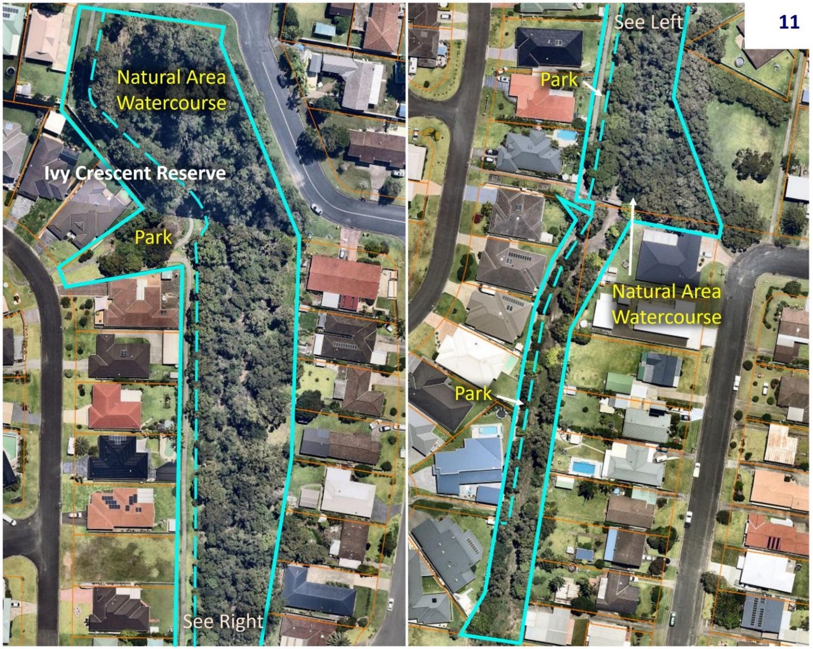
Draft Community Land Plan of Management Page 185 of 199

Draft Community Land Plan of Management Page 186 of 199

Draft Community Land Plan of Management Page 187 of 199

Draft Community Land Plan of Management Page 188 of 199

Draft Community Land Plan of Management Page 189 of 199

Draft Community Land Plan of Management Page 190 of 199

Draft Community Land Plan of Management Page 191 of 199

Draft Community Land Plan of Management Page 192 of 199

Draft Community Land Plan of Management Page 193 of 199

Draft Community Land Plan of Management Page 194 of 199

Draft Community Land Plan of Management Page 195 of 199

Draft Community Land Plan of Management Page 196 of 199

Draft Community Land Plan of Management Page 197 of 199

Draft Community Land Plan of Management Page 198 of 199
KEY STEPS IN PREPARING THE FIRST POM FOR CROWN RESERVES.
(from Page 7 – Developing Plans of Management for community land Crown reserves - NSW Department of Planning and Environment – Crown lands).

Draft Community Land Plan of Management Page 199 of 199
13
Appendix
midcoast.nsw.gov.au