5 minute read
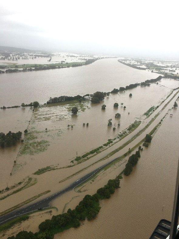
Figure 33: The Manning River floodplain, 20 March 2021

from Draft Manning River Catchment and Estuary and Catchment Management Program 2021-2031 - Main document

Figure 33: The Manning River floodplain, 20 March 2021
Photo: Evan Vale
6.10.2 Coastal Inundation
Coastal inundation is the flooding of coastal management areas by ocean waters, occurring “when a combination of marine and atmospheric processes raises ocean water levels above normal elevations and inundates low-lying” (Coastal Management Manual 2018).
Coastal inundation on the NSW coast is most often associated with east-coast lows
(Heimhuber et al 2019). It is typically a short-term event with waters receding to normal conditions. Coastal inundation from storm surge in the Manning River Estuary is caused by various process including low barometric pressure, strong onshore winds, high tides, and trapped coastal waves.
Coastal inundation in the Manning generally affects the open coast and low-lying
areas near the entrance, such as Harrington and Manning Point which are outside our Planning Area. For the Manning River ECMP Planning Area, threats associated with coastal inundation include rising groundwater, impacts on coastal wetlands and vegetation, inland estuary flooding and damage to riverbanks and infrastructure.
The Manning River Floodplain Management Study (BMT WBM 2019) considers flood events driven by both catchment and oceanic processes, addressing the current probability and future scenarios under climate change as shown above. Storm surge is factored into tailwater levels.
In general, coastal inundation causes more frequent nuisance flooding while riverine flooding is less frequent but causes more damage. Impacts include reduced efficiency of stormwater infrastructure and increased groundwater levels.
Modelling in the MRFMS (2019) shows that in storm events, the impact of water across land from high rainfall and riverine flooding will be more significant than the impact of coastal inundation. The flood mitigation, planning and emergency response measures set out in the MRFMS and Plan (2019) should therefore provide an effective management approach to coastal inundation. For more information see Section 10.
6.10.3 Tidal Inundation
Tidal Inundation or nuisance flooding is defined as “the inundation of land by tidal action under average meteorological conditions” (Coastal Management Manual 2018). It causes short term nuisance flooding in low-lying coastal areas.
Tidal inundation is mapped and managed through the Manning River Floodplain Risk
Management Study and Plan (BMT WBM 2019), using the High High-Water Spring tidal signature provided in the Flood Risk Management Guide (DECCW 205) for locations south of Crowdy Head as the ocean water level boundary.
Tidal inundation impacts on infrastructure such as roads, housing and stormwater systems is addressed in the Climate Change section of this document and the Climate Change Issue Paper provided as a supporting document.
6.11 Urban Stormwater and Litter
Urbanisation in the towns of Taree, Wingham, Harrington and Old Bar has created large areas of impervious surfaces such as roads, rooves, driveways and carparks. As a result, there is less infiltration of rainfall to ground water, increased stormwater overland flow velocities and greater volumes of runoff (Worley Parsons 2009).
Sediment transport is particularly problematic during the construction phase of urban development, when soils are exposed. Over the life of a development 80% of sediment lost occurs during the construction phase.
Pollutants typically found in stormwater include litter and microplastics, bacteria, nutrients, petrochemicals, pesticides, heavy metals, sediment and organic matter (NSW Govt. 2009).
A preliminary spatial risk assessment for the Manning River Estuary produced for the Manning River ECMP Scoping Study found that pollutant loads from urban stormwater are relatively low compared to catchment loads from agricultural land (MCC 2020).
Potential impacts include:
• Excess nutrients fuel algal blooms which lead to habitat loss impacting on the abundance and diversity of macroinvertebrates and aquatic fauna
• Visual pollution from gross pollutants impacting scenic amenity, town pride, tourism and recreation.
• Plastics can mimic natural food sources and injure/kill wildlife including birds, fish and dolphins.
• Sediment reduces the amount of light available for seagrass to grow, impacting aquatic fauna.
• Organic matter such as grass clippings reduces oxygen levels in the water as it breaks down, killing plants and animals.
In Taree, Browns Creek is an identified hot spot affected by runoff from the town centre and residential area which carries litter, hydrocarbons, sediments and nutrients into the creek.
In Wingham large catchments with aging infrastructure have led to increased erosion at outlets causing sedimentation in the local waterways, and as hydrocarbons and litter pollution at the Wingham Wetlands site next to the major shopping centre.
Management agencies: MidCoast Council (MCC), Hunter Local Land Service (Hunter LLS), DPIE – Environment, Energy and Science, NSW Government.
Community: Friends of Browns Creek; Team Taree, OzFish
Who's affected? Private landholders, MCC, Crown Lands, community members, fishing and oyster industry.
6.12 Biodiversity Loss
At the national level, key threats to biodiversity in aquatic ecosystems and marine receiving waters include diffuse-source water pollution, degraded riparian habitats and climate change, including the impacts of changed frequency, magnitude and intensity of floods and droughts56 .
In NSW, land clearing is currently the main threat to the extent and condition of native vegetation and habitat for terrestrial fauna57 . Clearing, degradation and fragmentation of vegetation due to land uses such as agriculture and urban development result in loss of diversity and degradation of natural terrestrial and aquatic environments(Commonwealth of Australia, 2017).
These threats are reflected in the Manning River estuary and catchment, where major stressors include:
• Habitat loss and degradation and fragmentation
• Water pollution from sediment and nutrients
• Changing climate including extreme weather events such as drought and widespread and intense wildfires
• Invasive plants (Senegal tea, long-leaf willow primrose, small and large-leaved privet, vine weeds) and pest animals (foxes, rabbits/hares, feral deer, feral pigs, goldfish)
• Diseases such as Phytophthora, Chytrid fungus and myrtle rust
• Altered hydrological regimes (e.g. weirs and causeways blocking fish passage)
• Land-uses such as forestry (private and public) and mining
• Manning River helmeted turtle: predation, habitat degradation and illegal collecting.
Loss of biodiversity (species and trophic levels) is classified as a high risk to social, economic and cultural benefits of the NSW Marine Estate58. The pressures that have pushed biodiversity and natural ecological systems in the catchment into decline also undermine the delivery of important ecosystems services, which in turn impacts social and economic drivers in the MidCoast Region.
Stakeholders: NSW National Parks and Wildlife Service (NPWS), MidCoast Council (MCC), DPIE, Hunter LLS; Purfleet-Taree Land Council, Taree Indigenous Development and Employment (TIDE); Gloucester Environment Group, MidCoast2Tops Landcare, Manning River Turtle Conservation Group, OzFish, Manning-Great Lakes Birdwatchers, Koalas in Care, FAWNA.
56 (Commonwealth of Australia, 2019) 57 (Commonwealth of Australia, 2017) 58 (Marine Estate Management Authority, 2018)


