
7 minute read
4 THE PHYSICAL ENVIRONMENT


4.1 Topography, Hydrology and Drainage
The Reserve lies within the Wallamba River catchment which drains eastward into Wallis Lake, exiting into the ocean near Forster. The Reserve is located on variable topographies from an elevated well drained ridge and crest in the northern section on which the majority of infrastructure exists. This landform falls relatively steeply to the south towards a poorly drained footslope which continues to the southern boundary. Local drainage from the Reserve eventually accesses the Wallamba River from various directions on the Reserve: via a flood prone western flowing drainage line which separates the two main landform units; to the east from the footslope and flat land at the southern end of the Reserve and to the north west from those more elevated terrains with northerly aspect.
Figure 5 visually depicts landform, aspect and drainage from the land.
Figure 5 - Topography, aspect and drainage
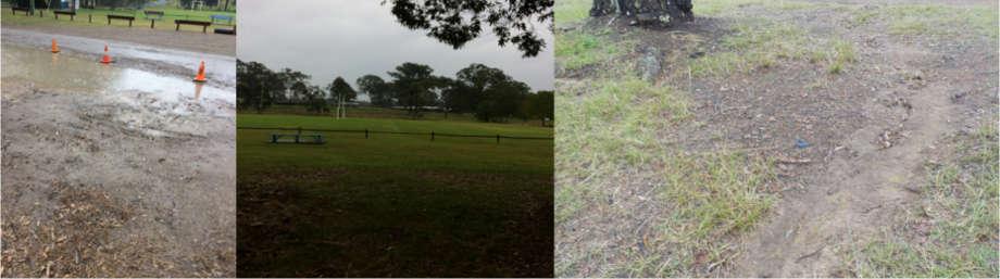
Clock-wise top left: crest of elevated land unit with vehicle track (south of main arena) is well drained; main arena slopes slightly to the north; well grassed slope with southern aspect, south of main arena; depicting erosive nature of soils where exposed on slopes; footslope to the south is poorly drained; carpark, at sporting field.
Because of its distance from the coastline, the Reserve is not impacted by the Coastal Management Act 2016. However, the above-mentioned western flowing drainage line is located on a footslope adjoining a floodplain, and is therefore subject to Clause 7.3 (Flood Planning) of the LEP.
Clause 7.3 objectives are to:
minimise the flood risk to life and property associated with the use of the land,
allow development on land that is compatible with the land’s flood hazard, taking into account projected changes as a result of climate change, and
avoid significant adverse impacts on flood behavior or the environment.
4.2 Land Clearing and Modification
During initial site development, post the original 1886 gazettal, the natural environment of the Reserve experienced modifications, commencing with the initial partial clearing of the land for its preparation. In following decades after the final and current gazettal of 1909, the land surface has been modified to allow establishment of the showground arena and hall (commencing 1911), and for the installation of all other infrastructure and facilities.
It is likely that the original vegetation would have been a dominant grassland interspersed with single or clumps of Eucalyptus (open) woodland trees and shrubs on the elevated topography, thickening into the small riparian area along the drainage line and the footslope to the south, carrying Melaleuca and Casuarina species in addition to a range of Eucalypts and understory shrubs.
A section of the survey map of 1902 (see Figure 6) for a section of the current Reserve, depicts the surveyor’s description of the original woody vegetation on the elevated ridge area to the south of the main arena (“Gum, Ironbark, Blackbutt, Bloodwood and Oak”). As described in that early survey, examples of the Ironbark, at least two additional Eucalypt (Gum) species, and an occasional Bloodwood (Corymbia species) tree, still remain on the ridge and its southern slope today.
Figure 6 - Compilation of the 1902 Survey of Portion 96 and the 1886 Village Survey

4.3 Soils and Geology
The soils of the Reserve closely reflect their origins, as:
soils formed in situ on the metasediments (siltstone/mudstone) of the elevated terrain, and which are acidic, reasonably well drained, with hard setting surfaces, and are of moderate soil erosion hazard. (Also see Figure 6 for original surveyor’s notes included in this area: “Gravel and Loam”.)
soils deposited alluvially or colluvially on the lower terrains of footslopes and drainage area, and which are acidic, poorly drained and often waterlogged.
Soil profile descriptions recorded in the vicinity of Nabiac and the Reserve for like-landforms within the NSW government’s soils database for the Bulahdelah 1:100,000 mapping sheet (www.environment.nsw.gov.au/eSpade2Webapp//) provide the following profile descriptions which have been generalised and condensed for this PoM:
Elevated terrain:
0-5 cm Brownish-black Silt Loam PH 5.5, few (0-20%) coarse fragments of gravel and ferromanganiferous materials
5-13 cm Sporadically bleached Yellowish Grey-Brown Sandy Clay Loam PH 5.5, few coarse materials
13-60 cm Yellowish Grey-Brown Light Medium Clay to Medium Heavy Clay, PH 5.0, strong/harsh structure. (Parent material mudstones, shales, sandstones normally encountered at or before this depth.)
Figure 7 depicts the coarse and loamy nature of these soils.
Footslope/drainage area:
0-10 cm Brownish-black Silt Loam, weakly structured PH 5.0 (field), sharp boundary to
10-35 cm Dull yellowish brown Silty Clay Loam with massive structure PH 5.5 ferro-manganiferous segregations common (10-20%), sharp boundary to
35-100 cm Dull yellow orange Silt Clay, strongly pedal (sodic).
Figure 7 - Surface soil material
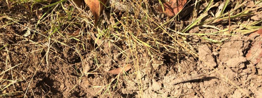

Elevated Terrain (southern slope): Exposed surface soil material (0-13cm), Nabiac Showground.
4.4 Vegetation and Habitat
Habitat values on the Reserve are associated with the following native and naturalised vegetation:
Plantings of a range of well-established tree species in the vicinity of the main buildings commencing in the main entrance area. These include well established Blackbutt (Eucalyptus pilularis), Tallowood (E. microcorys), and the introduced Camphor Laurel (Cynnamomum camphora).
The remnants of the (formerly described) native Ironbark dominant woodland on the higher topography and it southern side slope, also including groundcover grasses and broadleaved species (native and naturalised) which exist as part of the woodland, or on the open areas of maximum use including the main arena.
Naturally occurring ground cover species including grasses and a range of broadleaved species in the drainage area. On the playing fields, there is a well-maintained ground cover of turf species suitable for more intensive sporting uses by people.
A woodland of mixed native trees and shrubs of varying ages to the south of the playing fields in the southern section of the Reserve. These include Ironbark, Casuarina, Forest Red Gum, Melaleuca (paper bark), and native understory shrubs with a good cover of native and nonnative grasses. The introduced and weedy Camphor Laurel, Lantana and Mimosa are also present. A small constructed dam also complements habitat values in this section.
These vegetation distributions are well depicted in the aerial image (see Figure 2), and are also shown in Figure 8.
Figure 8 - Mature and semi mature native trees and habitat


Clockwise, top left: Camphor Laurel align main arena boundary; mature blackbutt trees, near main entrance and infrastructure; Ironbark trees on elevated terrain; mature Ironbark tree showing signs of senescence, elevated terrain; Paperbark and Casuarina on drainage area; Casuarina and associated grasses, woodland area (southern section); mature Eucalypt tree and understory, woodland area; Paperbark scrub, woodland area.
Note that the land at the Reserve is impacted by Clause 5.9 of the LEP, relating to the Preservation of Trees and Vegetation. This clause prohibits ring barking, cutting down, lopping, removing, injuring or willfully destroying trees and vegetation without Council consent.
Also note that this land is Bush Fire Prone land and is therefore subject to the Nabiac and Failford Fire Mitigation Plan (2007).
4.5 Biodiversity
Under the LGA, Council has obligations for conservation issues as determined by the Biodiversity Conservation Act 2016 and the Fisheries Management Act 1994. The LEP or the respective 149 certificates contain no notation of any significant biodiversity issues present at the Reserve. There is no biodiversity certified land or biobanking agreement associated with this land as per the Biodiversity Conservation Act 2016. Council’s Tree Preservation Order and Tree Inventory contains no trees of significance, on this site. Biodiversity value of the Reserve generally follows the descriptions provided in 4.4 above.
4.6 Riparian Land and Watercourses
There are no named creeks on or in the immediate vicinity of the Reserve. Section 3.2 above, describes a small section of the land occupied by the Reserve, as flood prone (see Figure 4). This is the small drainage line located between the footslope in the south, and the elevated terrain in the north which reaches the Wallamba River via an un-named drainage system.
The LEP presents Council’s objectives for the protection and maintenance of riparian lands and watercourses, including the nearby Wallamba River, by maintaining the following:
Water quality within watercourses
The stability of the bed and banks of watercourses
Aquatic and riparian habitat, and
Ecological processes within watercourses and riparian areas.


