3 minute read
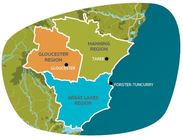
Figure 1. Rural, Environmental and Waterway zoned land considered in the Rural Strategy


3 Context
The scope of the Strategy is extensive. Essentially all land and water currently zoned for rural, environmental or waterway purposes throughout the MidCoast needs to be considered, this area is illustrated in Figure 1.
Simply put, over 95% of all land and water outside of the existing towns and villages of the MidCoast has been considered during the preparation of the Strategy.
Figure 1. Rural, Environmental and Waterway zoned land considered in the Rural Strategy
3.1 Preparing the draft Rural Strategy
The draft Rural Strategy is the culmination of locally focused research and engagement completed by a team of consultants in partnership with Council staff between 2017-2019. These efforts were targeted to:
• Provide a local understanding of the current strategic and legislative context, and the values of and the issues affecting the MidCoast's rural lands; • Collate and review the ‘evidence base’ that is currently available to inform and guide the direction of subsequent planning, based on research, site assessments, and high-level consultation with selected stakeholders; and • Support the vision and goals for rural areas set out in the MidCoast Regional
Economic Development Strategy and the Hunter Regional Plan 2036.
Public and stakeholder engagement efforts undertaken to prepare the draft Rural Strategy are described in the MidCoast Rural Strategy: Interim Engagement Report (City Plan Strategy and Development, 2018) and MidCoast Rural Strategy: Stage 1 Telephone Interviews - Outcomes Summary report (City Plan Strategy and Development, 2019).
City Plan Strategy and Development
City Plan Strategy and Development was the lead consultant organisation, coordinating the collection, and interpretation of information in the context of land use and development planning. This relied on engagement with key stakeholders and the broader community to consider specific issues in more detail. This project has benefitted from City Plan's specialist expertise as well as inputs provided by their established network of Government and private-sector planning professionals.
Aurora Research and Development
The Aurora R+ D team, based in Dubbo, undertook community and stakeholder engagement, including conducting over 60 telephone interviews with individuals and representatives of peak organisations. They also offered high-level advice in relation to a variety of sectors, including agriculture, agri-tourism, tourism, agronomy and marketing.
MJD Environmental
The MJD Environmental team, based in Newcastle, was responsible for the acquisition of spatial datasets from multiple stakeholders. This project has benefited from MJD's established relationships with relevant Government agencies, including the NSW Department of Planning, Infrastructure and Environment; Department of Primary Industries and Hunter & Central Coast Regional Environmental Management Strategy.
These and subsequent consultation and review processes are also documented in MidCoast Council’s Zoning In on Rural Land Communication and Consultation Strategy (2021).
The evidence base identified and reviewed by the consultant team through the engagement process and additional research, is described in more detail in a series of Background Reports prepared during 2018 - 2021.
3.2 Existing Planning framework
During preparation of this Strategy it has been recognised that the existing planning framework is failing communities and Council, as it is largely based on historic planning of the 1980s and 1990s.
Despite the transition of three local environmental plans and development control plans of the former local government areas of Gloucester, Great Lakes and Greater Taree into the Standard Principal Local Environmental Plan template in the mid-2000s, strategic improvements to the provisions and controls were generally not able to be made at that time.
The result is a suite of planning rules for waterways, rural and environmental areas of the MidCoast that are inconsistent, out-dated and closed to the opportunities that these vast areas and unique communities represent.
The aim of the Rural Strategy therefore, is to provide clear guidance on future planning across the rural landscape for implementation now and into the future, including reconsideration of the suite of zones referred to in Table 1, land uses, lot sizes for subdivision and development, assessment triggers and management options.
This has taken significant time, resources and collaboration. Due in part to the land area being considered, but as a new Council we have also had to create a baseline from which to start – What do we have? What do we know? Who are our stakeholders? What is working and more importantly, what is not?
This is consistent with a range of other strategies and plans being prepared across Council since amalgamation, including but not limited to the MidCoast 2030 Community Strategic Plan, MidCoast Destination Management Plan and Urban Zoning In program looking at Housing, Employment, Infrastructure and Recreation zones in our towns and villages.