We acknowledge the traditional custodians of the land on which we work and live, the Gathang-speaking people and pay our respects to all Aboriginal and Torres Strait Islander people who now reside in the MidCoast Council area. We extend our respect to Elders past and present, and to all future cultural-knowledge holders.
Appendix contents
APPENDIX 1: Draft MidCoast Local Environmental Plan
APPENDIX 2: Gateway Determination
APPENDIX 3: Assessment of Residential Areas
APPENDIX 4: Hunter Regional Plan 2041 Assessment
APPENDIX 5: State Environmental Planning Policy Assessment
APPENDIX 6: Ministerial Directions Assessment
APPENDIX 7: NSW Government Consultation
APPENDIX 8: MidCoast Housing Strategy
APPENDIX 9: MidCoast Rural Strategy – The Way Forward
APPENDIX 10: Paper Subdivision Analysis Report
APPENDIX 11: MidCoast Recreation Zones Review
APPENDIX 12: MidCoast Employment Zones Review
APPENDIX 13: MidCoast Infrastructure Zones Review
APPENDIX 14: Manning Health/Taree CBD Precinct Plan
APPENDIX 15: Zoning in Urban – Response to feedback
The purpose of this planning proposal is to outline the process, justify and explain the draft MidCoast Local Environmental Plan (referred to as the ‘draft MidCoast LEP’), which aims to provide one set of planning controls for the MidCoast. The draft MidCoast LEP is provided in Appendix 1.
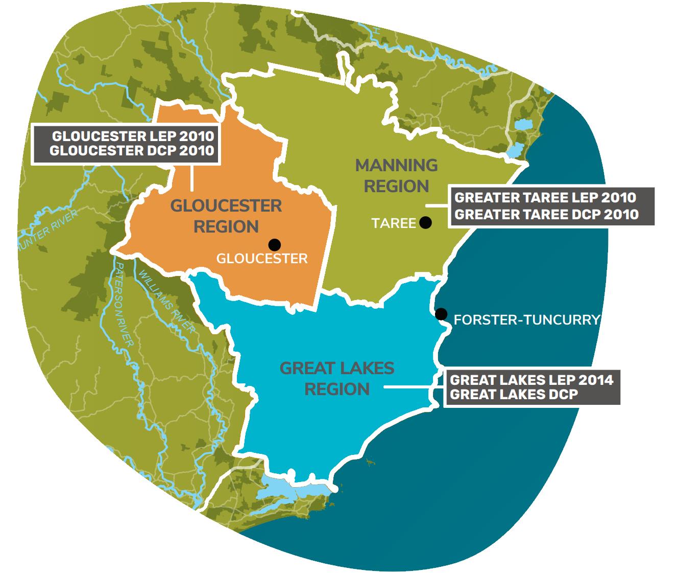
Currently, the MidCoast Local Government Area (referred to as the ‘MidCoast’) has three Local Environmental Plans (LEPs) being:
• Gloucester Local Environmental Plan 2010
• Great Lakes Local Environmental Plan 2014
• Greater Taree Local Environmental Plan 2010
Instead of consolidating the current LEPs, the approach was to undertake strategies and reviews to guide new planning controls for the MidCoast (referred to as ‘supporting documents’ and they are provided in Appendix 8-16). The supporting documents include:
• MidCoast Housing Strategy
• MidCoast Rural Strategy – The Way Forward
• Paper Subdivision Analysis Report
• Recreation Zones Review
• Employment Zones Review
• Infrastructure Zones Review
• Manning Health/Taree CBD Precinct Plan
• Zoning in Urban – Response to Feedback
• Rural Strategy – Supplementary Report
Each of these documents were developed in consultation with the community and guided the development of the draft MidCoast LEP.
The planning proposal has been prepared in accordance with Division 3.4 of the Environmental Planning and Assessment Act 1979 and the relevant Department of Planning, Housing and Infrastructure guidance, including the Local Environmental Plan Making Guideline (August 2023).
On 1 January 2024, the name of the Department of Planning and Environment changed to the Department of Planning, Housing and Infrastructure. In the supporting documentation, a reference to the Department of Planning and Environment must be read as a reference to the Department of Planning, Housing and Infrastructure
It should be noted that Council is not the Local Plan Making Authority for the draft MidCoast LEP.
The MidCoast
Spanning an area of 10,052km2, the MidCoast is the largest council area in the Hunter Region covering 30.5% of the region and 1.25% of NSW. It is a large and diverse area, ranging from beaches and coastline to mountains and hinterland, with rural landscapes, green spaces, and National Parks in between. The MidCoast is home to the Gathang speaking Aboriginal people, the Biripi and Worimi. The MidCoast has a population of approximately 97,090 people living in around 42,600 households.
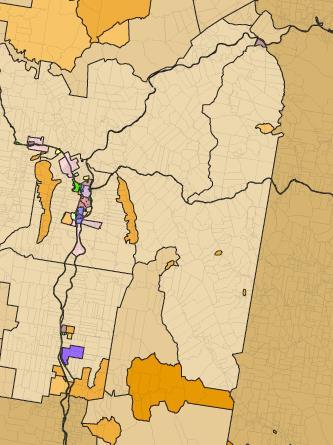
Formed by the merger of three councils and a County Council, the MidCoast currently has three sets of planning controls. Figure 1 shows the extent of the former councils and the planning controls that apply to those areas.
Supporting documents
The supporting documents provide the foundations for the draft MidCoast LEP. The following provides a summary of each document:
➢ MidCoast Housing Strategy – proposed a new framework for housing in the MidCoast. The aim was to offer a broad range of housing options to cater for our diverse needsfamilies, our ageing population and tourists, while maintaining the character of our towns and villages. A new suite of residential zones is proposed to address our different housing needs. Many of the towns and villages are examined with maps showing how the zones can apply (refer to Appendix 8).
➢ Rural Strategy – The Way Forward – this document responded to the key issues raised during community consultation on the draft Rural Strategy. During consultation a range of background studies were available which provided the foundations for the rural zones and planning provisions being applied across the MidCoast (this background information is available on Council’s website).
Figure 1: Extent of the former Councils and the planning controls that apply
The Rural Strategy – The Way Forward provides a clear approach for future planning relating to the rural, conservation and waterways zones and controls for specific issues such as paper subdivisions, urban release areas, drinking water catchments and areas of high velocity flooding. The Way Forward is based on evidence and takes on-board issues raised by the community, NSW Government and stakeholders (refer to Appendix 9).
➢ Paper Subdivision Analysis Report – examined the constraints affecting paper subdivisions in the MidCoast. This analysis found that the constraints notably limit the development potential in paper subdivisions and recommended changing the land included in paper subdivisions from a rural to an environmental zone (refer to Appendix 10).
➢ Recreation Zones Review – proposed a consistent and improved application of recreation zones across the MidCoast. The aim was to ensure our recreation lands provide a range of open space, sporting and community uses to meet the future needs of our residents (refer to Appendix 11).
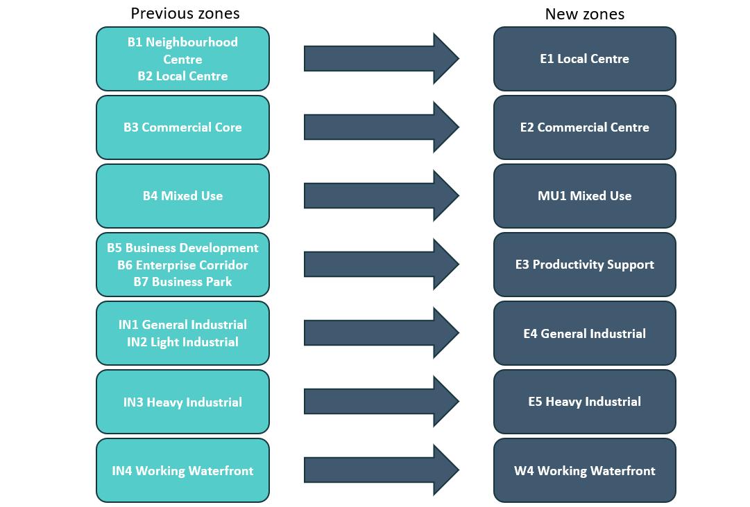
➢ Employment Zones Review – proposed a new framework for employment areas in the MidCoast, including our business and industrial centres. The aim was to ensure our employment zones support a thriving and growing economy and the flexibility to meet our future needs (refer to Appendix 12).
Much of the work undertaken in this Review has been changed and, in some cases, was implemented through the NSW Governments Employment Zones Reform, which was adopted in April 2023. The Reform involved transitioning the employment zones into a new suite of zones as shown in Figure 2 below.
➢ Infrastructure Zones Review – proposed a consistent and improved application of the infrastructure zone across the MidCoast. The aim was to ensure our infrastructure land is included in a suitable zone (refer to Appendix 13).
Figure 2: Changes to employment zones implemented through the NSW Employment Zones Reform
➢ Manning Health/Taree CBD Precinct Plan – aimed to facilitate businesses, particularly medical around the hospital. A new planning framework, along with improvements to our main streets will add vibrancy to the Taree town centre and encourage people to live within and in proximity to the town centre (refer to Appendix 14).
➢ Zoning in Urban – Response to feedback – this report responds to issues raised by the community, stakeholders and the NSW Government during consultation on the draft MidCoast Housing Strategy, Manning Health/Taree CBD Precinct Plan and the Employment, Recreation and Infrastructure Zones Reviews (refer to Appendix 15).
➢ Rural Strategy – Supplementary Report – this report responds to issues raised by the NSW Department of Primary Industries (Agriculture) during their review of the draft MidCoast LEP. The report addresses the historical application of the rural minimum lot sizes, the viability of rural activities and justifies the uses proposed in the rural zones (refer to Appendix 16).
Extensive consultation was undertaken on these documents to ‘check-in’ with the community prior to drafting the MidCoast LEP. The consultation was grouped as:
• Know Your Urban Zone - 5 February until 9 April 2020
• Know Your Rural Zone - 30 August 2021 until 28 January 2022.
Work in progress
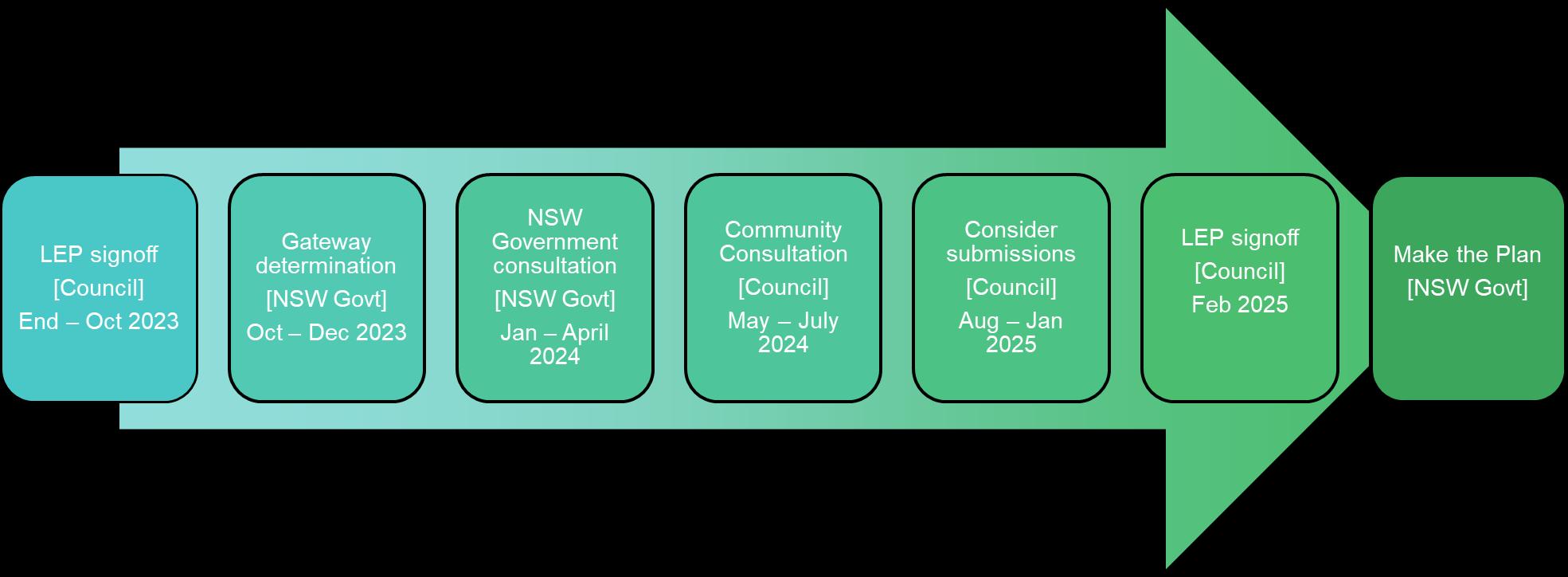
The high level process for the preparation of the draft MidCoast LEP is shown in Figure 3. This
The planning proposal is amended and updated throughout the above process. This version of the planning proposal has been amended to incorporate the community consultation. The Consultation Report (refer to Appendix 18-21) outlines the community consultation undertaken and proposed changes to the draft MidCoast LEP
Other projects are progressing parallel to the draft MidCoast LEP which may result in upcoming changes to the LEP. These projects are outlined below.
➢ Hallidays Point Place Strategy – this Strategy includes the coastal villages of Diamond Beach, Red Head, Black Head, and Tallwoods. This location has experienced significant growth over the last five years. The Strategy is being developed in partnership with the Department of Planning, Housing and Infrastructure to examine with the community the character of the area, ecological values, bushfire risks, traffic requirements and future growth.
It is envisaged that the Strategy will recommend changes to the draft MidCoast LEP. A key area of potential change is the tourist precinct in North Diamond Beach. The Housing Strategy recommended that this land be included in an R3 Medium Density Residential zone with a master planning process to determine the infrastructure requirements. This area will now be considered through the Strategy, so the land will remain in the SP3 Tourist zone in the draft MidCoast LEP
➢ Heritage Conservation Area Review – bringing together 14 heritage conservation areas across the three existing LEPs required a review to ensure a consistent approach was being applied. A draft review has been completed and is subject to further consultation, prior to inclusion in the draft MidCoast LEP.
➢ Conservation lands – across the three former Council areas, a range of agreements were in place with landowners to conserve their land. A review is being undertaken to determine if these lands were to be conserved in perpetuity and whether the zone of the land can be changed to a conservation zone to better reflect the intent for the land. Consultation with landowners is currently underway and changes to the zone of these sites are anticipated to be included in the draft MidCoast LEP.
➢ NSW Government consultation – more details are provided in section 3.4.2. Consultation with relevant NSW Government Departments and Agencies commenced in June 2023. Some issues are still being resolved which may result in changes to the draft MidCoast LEP.
➢ NSW Government planning reforms – new planning controls are consistently being developed by the NSW Government. Some of these reforms are mandatory and some are optional. Where Council makes the decision to adopt new planning controls, implementation may be required through the draft MidCoast LEP.
➢ Coastal risk planning – the Old Bar and Manning Point Coastal Management Plan (CMP) process is underway Once complete, it is anticipated that the CMP will recommend changes and be incorporated into the draft MidCoast LEP
➢ Planning proposals – Council is currently processing several planning proposals relating to specific sites in the MidCoast. Where these site-specific amendments are made prior to the finalisation of this planning proposal, it is intended they will be incorporated into the draft MidCoast LEP.
PART 1: OBJECTIVES AND INTENDED OUTCOMES
PART 1 - OBJECTIVES OR INTENDED OUTCOMES
The objective of this planning proposal is to create a single MidCoast Local Environmental Plan that will apply to the whole of the MidCoast area. This plan will replace the Gloucester, Great Lakes and Greater Taree Local Environmental Plans.
The draft MidCoast LEP will provide a common set of objectives, land use tables and provisions for land across the MidCoast. This will bring more consistency to planning controls and assist in reducing the complexity of the existing local planning framework.
The intended outcomes are to provide a LEP that:
• provides a consistent approach to planning across the MidCoast that is relevant and robust
• is responsive to the diverse landscapes and desired character across the MidCoast
• removes outdated or unnecessary controls
• gives effect to planning priorities for the MidCoast as outlined in the MidCoast Local Strategic Planning Statement 2020
• is consistent with the key directions from the supporting documents
The draft MidCoast LEP is being prepared to be consistent with the Standard Instrument (Local Environmental Plans) Order 2006, Standard Instrument – Principal Local Environmental Plan 2006 and relevant State government planning legislation, policy and guidelines.
PART
PART 2 - EXPLANATION OF PROVISIONS
The draft MidCoast LEP is provided in Appendix 1. The LEP has been prepared in accordance with the Standard Instrument (Local Environmental Plans) Order 2006 (referred to as Standard Instrument LEP).
The following provides a summary of the draft MidCoast LEP, which explains the key elements of each section of the LEP, what it aims to achieve, and where it originated from (e.g. existing LEPs or other NSW LEPs). Please note that the draft MidCoast LEP is made up of seven parts, six schedules and a dictionary as outlined below.
Additional amendments are proposed to the draft MidCoast LEP as a result of the community consultation. Proposed changes are outlined in the Consultation Report (refer to Appendix 18-21). In particular, Appendix C – LEP Specific (refer to Appendix 21) outlines specific amendments proposed to the draft MidCoast LEP document. The draft MidCoast LEP provided in Appendix 1 incorporates the proposed amendments.
2.1 Preliminary (Part 1 of LEP)
The aims proposed for the draft MidCoast LEP are listed below.
Part 1 – Preliminary (Aims)
• to protect and promote the use and development of land for arts and cultural activity, including music and other performance arts,
• to protect and enhance biodiversity, natural ecosystems, ecological processes and landscapes,
• to minimise the exposure of development to natural hazards, and promote climate change resilience,
• to promote the efficient and equitable provision of public infrastructure, facilities, and amenities,
• to encourage sustainable living, housing affordability and diversity,
• to encourage a strong sense of place, community, and character,
• to protect places and objects of cultural and heritage value,
• to support the well-being, belonging, and cultural identity of First Nations Peoples, through the care and continuation of the tangible and intangible aspects of cultural practices, resources, and knowledge systems,
• to support a strong, diverse, and sustainable economy,
• to encourage sustainable tourism that is compatible with surrounding environments,
• to support rural landscapes, rural enterprises and agricultural economic diversity, and protect important agricultural lands
2.2 Land use tables (Part 2 of LEP)
The land use zones of the existing three LEPs were reviewed, and inconsistencies were found in regard to how they were applied. The supporting documents provide a framework for how the zones are to be applied across the MidCoast. It is proposed to use the majority of the land use zones available in the Standard Instrument LEP (except RU6 Transition, SP1 Special Activities,
SP4 Enterprise and SP5 Metropolitan Centre) to address the diverse landscapes and urban areas across the MidCoast. The zones are listed over the page
By applying the large range of zones across the MidCoast, the character of towns, villages and rural landscapes has been considered in more detail. For example:
• the Greater Taree Local Environmental Plan 2010 only utilised the R1 General Residential zone for residential neighbourhoods. By applying the R1 General Residential zone through to the R4 High Density Residential zone in the draft MidCoast LEP, the character of the urban areas can be better defined, and apartments and townhouses can be encouraged close to town centres, services, and facilities. Information regarding the application of the residential zones is provided in the MidCoast Housing Strategy (refer to Appendix 8)
• the Gloucester Local Environmental Plan 2010 and Great Lakes Local Environmental Plan 2014 applied one rural zone to their rural landscapes, being the RU1 Primary Production and RU2 Rural Landscape zone respectively. By applying these zones along with the RU4 Primary Production Small Lots zone across the MidCoast rural landscape, the qualities of the rural lands can be better defined and reflected in the planning framework. Information regarding the application of the rural zones is provided in the Rural Strategy – The Way Forward (refer to Appendix 9) and Rural Strategy – Supplementary Report (refer to Appendix 16)
The Manning Health/Taree CBD Precinct Plan (refer to Appendix 14) promotes the most significant changes to the urban form in the draft MidCoast LEP. This plan encourages health facilities around the Manning Base Hospital and encourages more people to live close to the Taree Central Business District (CBD). In some locations building heights are proposed to increase from 8.5m up to 21m.
Part 2 – Land Use Tables
Rural Zones
RU1 Primary Production
RU2 Rural Landscape
RU3 Forestry
RU4 Primary Production Small Lots
RU5 Village
Employment Zones
E1 Local Centre
E2 Commercial Centre
E3 Productivity Support
E4 General Industrial
E5 Heavy Industrial
Special Purpose Zones
SP2 Infrastructure
SP3 Tourist
Recreation Zones
RE1 Public Recreation
RE2 Private Recreation
Residential Zones
R1 General Residential
R2 Low Density Residential
R3 Medium Density Residential
R4 High Density Residential
R5 Large Lot Residential
Conservation Zones
C1 National Parks and Nature Reserves
C2 Environmental Conservation
C3 Environmental Management
C4 Environmental Living
Mixed Use Zones
MU1 Mixed Use
Waterway Zones
W1 Natural Waterways
W2 Recreational Waterways
W3 Working Waterways
W4 Working Waterfront
An analysis of the existing and proposed residential zones for our towns and villages has been undertaken, and it identifies where there are proposed changes to the urban footprint (refer to Appendix 3) Overall, the extent of the urban footprint remains unchanged in many of our towns and villages
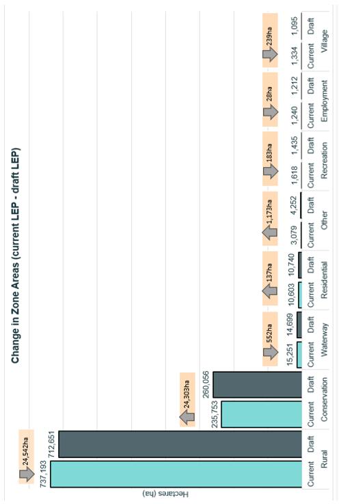
Figure 4 (over the page) provides an analysis of the application of the zones between the three existing LEPs and the draft MidCoast LEP.
The most identifiable change is a 25,542ha decrease in the extent that the rural zones have been applied, which is predominately as a result of land being included in a conservation zone. This zone change is also a result of the initiatives included in the Rural Strategy – The Way Forward (refer to Appendix 9), where land is proposed to be included in a conservation zone to address flooding and paper subdivisions, and for sites that adjoin National Parks which are proposed to be included in an C4 Environmental Living zone. While the number of hectares is large, it only equates to a 2.5% change of the zones applied across the whole MidCoast.
Other minor changes include:
• 1,173ha increase in the application of ‘Other’ zones which is predominately the Special Purpose zones for tourist and infrastructure uses. The Infrastructure Zones Review (refer to Appendix 13) applied a consistent approach to the application of zones over infrastructure such as future roads, hospitals, TAFE and water and sewage facilities which increased the application of this zone
• 552ha decrease in the extent of the waterways zones. This is due to conservation zones (particularly C1 National Parks and Nature Reserves and C2 Environmental Conservation zones) adjoining and overlaying waterways, and removing the underlying waterways zone
• 239ha decrease in the RU5 Village zone where some settlements have been removed from the village zone as they do not have the range of services and facilities considered to be a village
• 183ha decrease in recreation zones. The Recreation Zones Review (refer to Appendix 11) applied a consistent approach to the application of zones over public reserves. In many cases a recreation zone applied over important waterways or environmental corridors. These locations have been changed to be included in a conservation zone to reflect the environmental values of the land
• 137ha increase in residential zones. This is as a result of a number of changes, including the reduction in the employment zone around Gloucester town centre and inclusion of this land in a residential zone and minor changes to the urban footprint identified in Appendix 3
• 28ha reduction in employment zones. The Employment Zones Review (refer to Appendix 12) applied a consistent approach to the application of employment zones over industrial and commercial land. In particular, there was a decrease in the extent of the Gloucester town centre, which would contribute to this reduction.
Following on from the supporting documents, minor refinements were made when including the land use tables in the draft MidCoast LEP. This was to refine the intent of the zones and reflect requirements from NSW Government Departments through the Gateway Determination and consultation (refer to Appendix 2 and 7) Further refinement is proposed as a result of the community consultation. Proposed changes to the land use tables are outlined in the Consultation Report (refer to Appendix 18-21).
Figure 4: Comparison of the application of zones between the existing LEPs and draft MidCoast LEPs
As outlined above, these changes are as a result of applying a common approach to how the zones are applied across the MidCoast. With the MidCoast spanning an area of 10,052km2, (1,005,200ha) this extent of change is reasonable in the application of the zones.
2.3 Exempt and complying development (Part 3 of LEP)
The Standard Instrument LEP provisions apply.
Additional considerations were added to the clause 3.3(2) for what is considered “environmentally sensitive area for exempt or complying development”. The following were added:
• land within 100m of coastal waters of the State or a coastal lake
• land identified as “Protection Corridor” on the Protection of Wildlife Corridors Map.
2.4 Principal development standards (Part 4 of LEP)
The principal development standards were generally consolidated from across the three existing Local Environmental Plans (LEPs). The following provides a summary of which clauses will be used in the draft MidCoast LEP, the intent of each clause and where the clause was drawn from.
Please note that the following numbering is as per the draft MidCoast LEP and as specified in the Standard Instrument LEP.
A number of these principal development standards are proposed to be refined as a result of the community consultation. Proposed changes are outlined in the Consultation Report (refer to Appendix 18-21).
The draft MidCoast LEP (refer to Appendix 1) provides the wording of each clause discussed below and has been amended to include changes proposed as a result of the community consultation.
4.1 Minimum subdivision lot size
This clause is a Standard Instrument LEP clause used in the three existing LEPs. The objectives of the clause have been revised; however, the intent and operation of the clause remains unchanged.
4.1AA Minimum subdivision lot size for community title schemes
This clause is a Standard Instrument LEP clause used in the three existing LEPs. The objectives of the clause have been revised; however, the intent and operation of the clause remains unchanged.
4.1A Exceptions to minimum lot size for boundary adjustments
This clause is used in the three existing LEPs. The objectives of the clause have been revised; however, the intent and operation of the clause remains unchanged.
4.1B Exceptions to minimum lot sizes for certain residential development
This clause is used in the Great Lakes Local Environmental Plan 2014. The intent of this clause is to allow higher density residential development on lots that are smaller than the mapped minimum lot size for land included in the R1 General Residential, R2 Low Density Residential and R3 Medium Density Residential zones, and where the development is integrated into the subdivision design.
The clause has been expanded to include the R1 General Residential zone, however this does not change the intent of the clause.
4.1C Subdivision and servicing of certain lots
This clause is used in the Greater Taree Local Environmental Plan 2010. The intent of this clause is to regulate the subdivision of land to ensure that new lots which are created in the RU5 Village, R1 General Residential, R2 Low Density Residential, R3 Medium Density Residential, R4 High Density Residential and R5 Large Lot Residential zones (with a minimum lot size of 4,000sqm or less) can be serviced by reticulated water and sewerage.
The clause has been expanded to include the R3 Medium Density and R4 High Density Residential zones; however this does not change the intent of the clause.
4.1D Exceptions to minimum subdivision lot sizes for certain split zones
This clause is used in the Great Lakes Local Environmental Plan 2014 and Greater Taree Local Environmental Plan 2010. The intent of this clause is to allow the subdivision of land in certain zones below the minimum lot size where the lot is in certain split zones.
The clause has been expanded to include all zones listed in both the Great Lakes Local Environmental Plan 2014 and Greater Taree Local Environmental Plan 2010, however this does not change the intent of the clause.
4.1E Subdivision of land adjoining certain rural, residential, or environmental protection zones
This is a new clause proposed to be adopted in the draft MidCoast LEP. The intent of this clause is to protect adjoining agricultural and environmental values, minimise land use conflict, and consider the natural and physical constraints of the land. The clause ensures consideration of the impacts of development upon uses on adjoining land in the RU1 Primary Production, RU2 Rural Landscape, RU3 Forestry, RU4 Small Lot Primary Production, C1 National Parks and Nature Reserves, C2 Environmental Conservation, C3 Environmental Management, C4 Environmental Living zones.
4.1F Exception to minimum lot sizes for ecological protection
This clause is based on clause 4.1B in the Great Lakes Local Environmental Plan 2014. The intent of the clause is to provide a possible development outcome in return for the improvement and protection of environmentally sensitive land or high value conservation land for ecological and service purposes. A planning agreement is required to outline the intended conservation and development outcome, which will then be achieved through this clause.
4.2 Rural subdivision
A Standard Instrument LEP clause used in the three existing LEPs. The intent of this clause is to provide flexibility in the application of standards for rural subdivisions to allow landowners a greater chance to achieve the objectives for development in the relevant zone.
4.2A Erection of dwelling houses on land in certain rural and environmental protection zones
This clause is used in the three existing LEPs. The intent of this clause is to outline the considerations for dwelling entitlements in rural and conservation zones.
The clause has been expanded to include the C4 Environmental Living zone; however, this does not change the general intent of the clause. As part of the draft MidCoast LEP it is proposed to include a 2-year sunset provision on existing holdings.
4.2B Minimum subdivision lot size for certain strata subdivisions
This clause is used in the Gloucester Local Environmental Plan 2010. The intent of this clause is to prevent fragmentation of land in certain rural and conservation zones by creating additional dwelling entitlements through a strata title subdivision.
The objectives of the clause have been revised and the number of applicable zones expanded, however the intent or operation of the clause remains unchanged.
4.3 Height of buildings
A Standard Instrument LEP clause used in the three existing LEPs. The objectives of the clause have been revised; however, the intent and operation of the clause remains unchanged.
4.4 Floor space ratio
A Standard Instrument LEP clause used in the three existing LEPs. The objectives of the clause have been revised; however, the intent and operation of the clause remains unchanged. Floor space ratio was applied to locations where the building height is 26m or more in the draft MidCoast LEP as required by condition 1(k) of the Gateway Determintion (refer to Appendix 2)
4.5 Calculation of floor space ratio and site area
A Standard Instrument LEP clause used in the three existing LEPs. Floor space ratio was applied to locations where the building height is 26m or more in the draft MidCoast LEP as required by condition 1(k) of the Gateway Determintion (refer to Appendix 2).
4.6 Exceptions to development standards
A Standard Instrument LEP clause used in the three existing LEPs. Additional considerations were added to 4.6(11) where this clause does not allow development consent to be granted where it would contravene specific clauses in the draft MidCoast LEP. This clause was reviewed and amended to address new Ministerial Direction 1.4A Exclusion of development standards from variation and condition 1(n) of the Gateway Determintion (refer to Appendix 2).
2.5 Miscellaneous provisions (Part 5 of LEP)
The Standard Instrument LEP contains twenty-five clauses that are either listed as compulsory or optional. The list of miscellaneous provisions to be included in the draft MidCoast LEP is provided over the page
A number of these miscellaneous provisions are proposed to be refined as a result of the community consultation. Proposed changes are outlined in the Consultation Report (refer to Appendix 18-21).
The draft MidCoast LEP (refer to Appendix 1) provides the wording of each clause discussed below and has been amended to include changes proposed as a result of the community consultation.
Part 5 – Miscellaneous provisions
• 5.1 Relevant acquisition authority
• 5.1A Development on land intended to be acquired for public purposes
• 5.2 Classification and reclassification of public land
• 5.3 Development near zone boundaries
• 5.4 Controls relating to miscellaneous permissible uses
• 5.5 Controls relating to secondary dwellings on land in a rural zone (Note: the total floor area of the dwelling is not to exceed whichever is the greater being 100m2 or 50% of the principal dwelling)
• 5.7 Development below mean high water mark
• 5.8 Conversion of fire alarms
• 5.9 Dwelling house or secondary dwelling affected by natural disaster
• 5.10 Heritage conservation
• 5.11 Bush fire hazard reduction
• 5.12 Infrastructure development and use of existing buildings of the Crown
• 5.13 Eco-tourist facilities
• 5.16 Subdivision of, or dwellings on, land in certain rural, residential or conservation zones
• 5.18 Intensive livestock agriculture
• 5.19 Pond-based, tank-based and oyster aquaculture
• 5.20 Standards that cannot be used to refuse consent–playing and performing music
• 5.21 Flood planning
• 5.24 Farm stay accommodation
• 5.25 Farm gate premises
Clause 5.4 enables Council to set the parameters for the listed miscellaneous permissible uses. The draft MidCoast LEP has included the following:
• bed and breakfast accommodation – no more than 5 bedrooms
• home business – no more than 50m2
• home industries – no more than 120m2
• industrial retail outlets – not exceed 43% Gross Floor Area or 400m2 whichever is lesser
• farm stay accommodation – no more than 5 bedrooms in buildings
• kiosks – not exceed 65m2
• neighbourhood shops – not exceed 250m2
• neighbourhood supermarkets – not exceed 1,000m2
• roadside stalls – not exceed 10m2
• secondary dwellings on land other than in a rural zone – 60m2 or 50% of the total floor area of principal dwelling As a result of the community consultation, it is proposed to reduce this to 35% rather than 50% in clause 5.4 and 5.5 (refer to the Consultation Report in Appendix 18-21).
• artisan food and drink industry exclusion – not exceed 43% of 400m2, whichever is the lesser.
The following clauses are not proposed to be included in the draft MidCoast LEP:
• Architectural roof features
• Siding Spring Observatory–maintaining dark sky
• Defence communications facility
• Artificial waterbodies in environmentally sensitive areas in areas of operation of irrigation corporations
• Public bushland.
2.6 Urban release areas (Part 6 of LEP)
Part 6 clauses were used in the Great Lakes Local Environmental Plan 2014 and Greater Taree Local Environmental Plan 2010. The draft MidCoast LEP incorporates clauses from both of these LEPs. The intent remains generally unchanged.
Please note that the following numbering is as per the draft MidCoast LEP and as specified in the Standard Instrument LEP.
The draft MidCoast LEP (refer to Appendix 1) provides the wording of each clause discussed below and has been amended to include changes proposed as a result of the community consultation.
Division 1 General
6.1 Concurrence of Planning Secretary
The intent of this clause is to require concurrence of the Planning Secretary for development consent for the subdivision of land in an urban release area.
6.2 Public utility infrastructure
The intent of this clause is to ensure development consent for the subdivision of land in an urban release area ensures that adequate infrastructure will be available.
6.3
Development Control Plan
The intent of this clause is to ensure development of land in an urban release area occurs in a logical and cost effective manner and in accordance with a Development Control Plan (DCP) for the area. The range of considerations for the Development Control Plan are listed and include transport movement, landscaping, network of recreation areas. A minor amendment is
proposed to this clause as a result of the community consultation (refer to the Consultation Report in Appendix 18-21).
6.4 Relationship between Part and remainder of Plan
The intent of this clause is to ensure that this Part prevails over any other provision of the draft MidCoast LEP to the extent of any inconsistency.
Division 2 North Tuncurry Urban Release Area
This Division outlines the development requirements of the North Tuncurry Urban Release Area, including minimum lot sizes, affordable housing, concurrences with the Planning Secretary and Transport for NSW, and requirements for studio dwellings. It is based on the Great Lakes Local Environmental Plan 2014.
Division 3 Additional development areas
This Division outlines the development requirements for Stratford Industrial Park. In particular, requesting the assistance of NSW Government Departments to provide satisfactory regional road infrastructure for any development of the land. These provisions were contained in Part 7 of the Gloucester Local Environmental 2010.
2.7 Additional Local Provisions (Part 7 of LEP)
Given the diversity of landscapes and urban areas, twenty-eight local provisions are proposed. This includes many of the local provisions that currently apply across the three existing LEPs. There are seven provisions that relate to specific locations that will remain, while seven new provisions have been introduced based on model clauses in LEPs across NSW.
Please note that the following numbering is as per the draft MidCoast LEP.
A number of these local provisions are proposed to be refined or removed as a result of the community consultation. Proposed changes are outlined in the Consultation Report (refer to Appendix 18-21).
The draft MidCoast LEP (refer to Appendix 1) provides the wording of each clause discussed below and has been amended to include changes proposed as a result of the community consultation.
7.1 Acid sulfate soils
The intent of this clause is to ensure that development does not disturb, expose or drain acid sulfate soils and cause environmental damage. This clause is used in the Great Lakes Local Environmental Plan 2014 and Greater Taree Local Environmental Plan 2010. The Greater Taree Local Environmental Plan 2010 had separated the Class 2 soils to be Class 2a and 2b, and this will be retained in the draft MidCoast LEP. The intent and operation of this clause remains unchanged.
7.2 Earthworks
The intent of this clause is to ensure that earthworks will not have a detrimental impact on environmental functions and processes, neighbouring uses, cultural or heritage items or features of the surrounding land. It also allows earthworks of a minor nature without requiring
separate development consent. This clause is used in the Great Lakes Local Environmental Plan 2014 and Greater Taree Local Environmental Plan 2010. The wording has been revised based on a similar clause in the Cumberland Local Environmental Plan 2021. The intent and operation of this clause remains unchanged.
7.3 Coastal risk planning
The intent of this clause is to avoid impacts from coastal hazards and ensure compatible land uses in areas subject to coastal hazards allow for safe evacuation. This clause is used in the Great Lakes Local Environmental Plan 2014. While the extent of coastal risk has been extended over the larger MidCoast, the intent and operation of this clause remains unchanged.
7.4 Stormwater management
The intent of this clause is to minimise the impacts of urban stormwater on properties, native vegetation and receiving waters, and protect the environmental values of water identified for urban waterways in the various sensitive catchments through the MidCoast which also serve as drinking water catchments and priority oyster aquaculture areas. This clause is used in the Great Lakes Local Environmental Plan 2014, and it is proposed to be included in the draft MidCoast LEP with minor amendments. While the extent of stormwater management has been extended over the larger MidCoast, the intent and operation of this clause remains unchanged.
7.5 Drinking water catchments
The intent of this clause is to protect and maintain key drinking water catchments (above ground) throughout the MidCoast. This clause is used in the Great Lakes Local Environmental Plan 2014. The key drinking water catchments (above ground) have been mapped and included in the draft MidCoast LEP mapping. While the catchment areas have increased, the intent and operation of this clause remains unchanged.
7.6 Riparian land and watercourses
The intent of this clause is to protect and maintain the quality of watercourses and riparian areas. This clause is used in the Great Lakes Local Environmental Plan 2014 with mapped watercourses. The clause has been amended to use the Strahler stream system in lieu of a watercourse mapping. While the extent of watercourses has extended over the larger MidCoast, the intent and operation of this clause remains unchanged.
7.7
Groundwater vulnerability
The intent of this clause is to protect and maintain key underground drinking water catchments (aquifers) throughout the MidCoast. This clause is not used in the three existing LEPs. This clause is based on similar clauses used in the Parkes Local Environmental Plan 2012, Dubbo Regional Local Environmental Plan 2022, Bogan Local Environmental Plan 2011 and Lachlan Local Environmental Plan 2013.
The underground aquifer catchments at Nabiac and Tea Gardens have been mapped and included in the draft MidCoast LEP mapping.
7.8 Protection of wildlife corridors
The intent of this clause is to protect and maintain biodiversity corridors over specific mapped areas. This clause is used in the Great Lakes Local Environmental Plan 2014. The intent and operation of this clause remains unchanged It is proposed to add to the mapped areas in the future.
7.9 Limited development on foreshore area
The intent of this clause is to ensure that development in the foreshore area will not impact on natural foreshore processes or affect the significance and amenity of the area. This clause is used in the Great Lakes Local Environmental Plan 2014. The foreshore areas have been mapped and included in the draft MidCoast LEP mapping. While the foreshore areas have increased, the intent and operation of this clause remains unchanged.
7.10 Active street frontages
The intent of this clause is to ensure that development on the ground floor in our strategic centres contributes to a vibrant economy. This clause is used in the Great Lakes Local Environmental Plan 2014 and has been amended to incorporate features of the clause in the Byron Local Environmental Plan 2014. The active street frontages have been mapped and included in the draft MidCoast LEP mapping. While the active street frontages have increased, the intent and operation of this clause remains unchanged.
7.11 Development at Seven Mile Beach, The Lakes Way, Forster
The intent of this Great Lakes Local Environmental Plan 2014 clause is to ensure ecologically sound development on the highly constrained site at Seven Mile Beach. The site has been included on the Key Sites Map and is included in the draft MidCoast LEP mapping. The intent and operation of this clause remains unchanged.
7.12 Residential accommodation at Winda Woppa
The intent of this Great Lakes Local Environmental Plan 2014 clause is to limit the intensity of development on the sensitive Winda Woppa peninsula which is subject to ongoing coastal and beach erosion impacts. The site has been included on the Key Sites Map and is included in the draft MidCoast LEP mapping. The intent and operation of this clause remains unchanged.
7.13 Development at Carmona Drive, South Forster
The intent of this Great Lakes Local Environmental Plan 2014 clause is to ensure that the intensity of development is limited on this ecologically and access constrained site. The site has been included on the Key Sites Map and is included in the draft MidCoast LEP mapping. The intent and operation of this clause remains unchanged.
7.14 Subdivision of land at Brimbin in Zone RU4
The intent of this Greater Taree Local Environmental Plan 2010 clause is to facilitate the creation of smaller scale clustered agricultural development in accordance with the future Brimbin Development Control Plan. The site has been included on the Key Sites Map and is included in the draft MidCoast LEP mapping. The intent and operation of this clause remains unchanged.
7.15 Subdivision of land at Brimbin in Zone C4
The intent of this Greater Taree Local Environmental Plan 2010 clause is to facilitate the creation of smaller scale eco-living development in accordance with the future Brimbin Development Control Plan. The site has been included on the Key Sites Map and is included in the draft MidCoast LEP mapping. The intent and operation of this clause remains unchanged.
7.16 Use of industrial land, Cundletown
The intent of this Greater Taree Local Environmental Plan 2010 clause is to facilitate the development of Cundletown Northern Gateway transport and logistics hub. Minor amendments were made to the clause. The site has had been included on the Key Sites Map and is included in the draft MidCoast LEP mapping. The intent and operation of this clause remains generally unchanged.
7.17 Commercial premises in Zone MU1
The intent of this clause is to maintain the viability of commercial centres by limiting the floor area of retail premises in Mixed Use zone. This clause is not used in the three existing LEPs and is based on a clause in the Coffs Harbour Local Environmental Plan 2013.
7.18 Caretaker’s residence
The intent of this clause is to provide considerations for establishing caretaker’s residences in the E4 General Industrial and E5 Heavy Industrial zones as an ancillary use to the ‘general industry’ proposed or established on the site. A caretakers residence is for a full-time caretaker to manage and maintain the premises. This clause is not used in the three existing LEPs and is based on a clause in the Coffs Harbour Local Environmental Plan 2013.
7.19 Development on land in karst areas
The intent of this clause is to ensure that development in the vicinity of karst (underground caves) both protects karts landscapes and avoids adverse risk to property. This clause is not used in the three existing LEPs. This clause is based on similar clauses in the Coffs Harbour Local Environmental Plan 2013, Dubbo Local Environmental Plan 2022, Cowra Local Environmental Plan 2012 and Kempsey and Oberon Local Environmental Plans 2013.
7.20 Development on steep land
The intent of this clause is to provide for the appropriate management of land with a slope of over 18 degrees. This clause is not used in the three existing LEPs and is based on a clause in the Queanbeyan-Palerang LEP 2022.
7.21 Protection of rural landscapes in rural and conservation zones
The intent of this clause is to ensure that development in rural and conservation zones (which do not have a maximum building height) are consistent with rural amenity and avoid visual impacts. This clause is not used in the three existing LEPs and is based on a clause in the Dungog Local Environmental Plan 2014.
7.22 Events permitted without development consent
The intent of this clause is to allow for certain events to be permitted without development consent. This clause is used in the three existing LEPs. The intent and operation of this clause remains unchanged.
7.23 Essential services
The intent of this clause is to ensure that the essential services for the proposed development are available or that adequate arrangements have been made to make them available when required. This clause is used in the Great Lakes Local Environmental Plan 2014 and Greater Taree Local Environmental Plan 2010. While the clause will apply over the larger MidCoast area, the intent and operation of this clause remains unchanged.
7.24 Location of sex services premises
The intent of this clause is to minimise land use conflicts and adverse amenity impacts by providing a reasonable level of separation between sex services premises, specified land uses and places regularly frequented by children. This clause is used in the Great Lakes Local Environmental Plan 2014. While the clause will apply over the larger MidCoast area, the intent and operation of this clause remains unchanged.
7.25 Restriction of certain development in rural and conservation zones
The intent of this clause is to ensure that development on land in rural and conservation zones only occurs where there is a dwelling entitlement. This clause is used in the Great Lakes Local Environmental Plan 2014 and Gloucester Local Environmental Plan 2010. While the clause will apply over the larger MidCoast area, the intent and operation of this clause remains unchanged.
As a result of community consultation, this clause is proposed to be removed (refer to Appendix 21) and the following local provisions will be renumbered accordingly
7.26 Airspace operations
The intent of this clause is to ensure that development in the vicinity of the Taree Airport does not create safety risks either for the airport operational procedures or due to extension into the obstacle limitation surface. This clause is used in the Greater Taree Local Environmental Plan 2010 and was updated to reflect recent clauses particularly Central Coast Local Environmental Plan 2022. The intent and operation of this clause remains unchanged.
7.27 Development in areas subject to aircraft noise
The intent of this clause is to ensure development considers the adverse effects of aircraft noise in the vicinity of the Taree Airport. This clause is used in the Greater Taree Local Environmental Plan 2010. The intent and operation of this clause remains unchanged. However, the ANEF map has been removed as an LEP map, given the map is prepared by the Commonwealth Department responsible for airports. This approach has been consistently applied in new LEPs across NSW.
7.28 Development on land in paper subdivisions
The intent of this clause and associated draft MidCoast LEP mapping seeks to identify land in paper subdivisions The clause provides additional criteria for Development Control Plans to be considered for paper subdivision sites. This clause is not used in the three existing LEPs and is based on a clause in the Blue Mountains Local Environmental Plan 2013 and Lake Macquarie Local Environmental Plan 2014
Originally two clauses, the clauses have been consolidated into one in accordance with condition 9(m)(ii) of the Gateway Determintion (refer to Appendix 2).
2.8 Additional permitted uses (Schedule 1 of LEP)
Of the twenty additional permitted uses (APUs) listed in the existing LEPs, eight remained in the draft MidCoast LEP. Three of these uses related to tourist provisions which have been combined into one APU clause that applies over three sites.
The ten uses being removed are a result of the following:
• the land has been developed for the intended APU purposes and therefore is no longer relevant; or
• the land use that is permissible with consent in the APU will now be permissible with consent in the proposed new zone relating to that land.
The planning proposal does not list the APUs as a Lot and DP, as these are subject to change. All APU’s will be mapped and referenced in the draft MidCoast LEP with Area Reference numbers (e.g. Area 1).
A number of APUs are proposed to be added to the draft MidCoast LEP as a result of the community consultation. Proposed changes are outlined in the Consultation Report (refer to Appendix 18-21).
The draft MidCoast LEP (refer to Appendix 1) provides the wording of each APU and has been amended to include changes proposed as a result of the community consultation.
2.9 Exempt development (Schedule 2 of LEP)
The exempt development provisions in the three existing LEPs were reviewed. Clauses were removed where the development is addressed by the various State Environmental Planning Policies. Based on a review across NSW of recently updated and recently made LEPs, a number of new clauses are proposed to ensure best practice.
The following are the exempt development provisions included in the draft MidCoast LEP. Please note that the following numbering is as per the draft MidCoast LEP.
Changes are proposed to the exempt development listed in the draft MidCoast LEP as a result of the community consultation. A number of new clauses are proposed. The proposed changes are outlined in the Consultation Report (refer to Appendix 18-21).
The draft MidCoast LEP (refer to Appendix 1) provides the wording of each clause discussed below and has been amended to include new exempt development provisions and changes proposed as a result of the community consultation.
1. Boundary adjustments
The intent of this clause is to enable minor boundary adjustments under certain listed circumstances. This clause is used in the Greater Taree Local Environmental Plan 2010. While the extent of adjustment of the lot size has increased from 5% to 10% in the draft MidCoast LEP, the intent and operation of this clause remains unchanged.
2. Bus shelters (other than by or for the Council)
The intent of this clause is to enable bus shelters for developments like aged care facilities in accordance with the specifications listed. This clause is used in the Greater Taree Local Environmental Plan 2010 and the intent and operation of this clause remains unchanged.
As a result of community consultation, this exempt development clause is proposed to be removed (refer to Appendix 21) and the following exempt development provisions will be renumbered accordingly.
3. Dams (in Zones RU1, RU2, RU3, RU4)
The intent of this clause is to enable to farm dams in rural zones in accordance with the specifications listed. This clause is used in the Greater Taree Local Environmental Plan 2010. The clause was amended to align with the harvestable rights order, but the intent and operation of this clause remain generally unchanged.
4. Pole or pylon signs in employment zones (in Zones E1, E2, E3, E4, E5 and MU1)
The intent of this clause is to enable pylon or pole signs in employment zones and the Mixed Use zone in accordance with the specifications listed. This clause is an extract from the clause used in the Gloucester Local Environmental Plan 2010. The Gloucester clause was reviewed against the State Environmental Planning Policy (Exempt and Complying development Codes) 2008 and it was found that these types of signs were not adequately addressed in the Policy. As such, the clause was amended to only relate to pole or pylon signs.
5. A frame signs
The intent of this clause is to enable A frame signs in front of businesses in accordance with the specifications listed. This clause is drawn from the Queanbeyan-Palerang Local Environmental Plan 2022 and is consistent with Council’s Footpath Activities in Town Centres Policy.
6. Bus shelter advertising
The intent of this clause is to enable bus shelter advertising in accordance with the specifications listed. This clause is drawn from the Queanbeyan-Palerang Local Environmental Plan 2022.
7. Display of goods on footpaths
The intent of this clause is to enable the display of goods on footpaths in accordance with the specifications listed. This clause is drawn from the Shoalhaven Local Environmental Plan 2014 and is consistent with Council’s Footpath Activities in Town Centres Policy.
8. Street art
The intent of this clause is to enable street art in accordance with the specifications listed. This clause is drawn from the Sydney Local Environmental Plan 2012.
9. Property identification signs in rural and conservation zones
The intent of this clause is to enable property identification in rural and conservation areas in accordance with the specifications listed. This clause is drawn from the QueanbeyanPalerang Local Environmental Plan 2022.
10. Existing cemeteries or burial grounds (thar are not heritage items)
The intent of this clause is to enable certain works in existing cemeteries or burial grounds in accordance with the specifications listed. This clause is drawn from the Tweed Local Environmental Plan 2014.
11. Solid fuel heaters
The intent of this clause is to enable solid fuel heaters in accordance with the specifications listed. This clause is drawn from the Queanbeyan-Palerang Local Environmental Plan 2022.
12. Small scale commercial use of public land (including waterways on public land) including personal or group training, dog training, water sports, swimming or surf schools, and sightseeing or recreational tours
The intent of this clause is to enable small scale use of public land in accordance with the specifications listed. This clause is drawn from the Eurobodalla Local Environmental Plan 2012.
2.10 Complying development (Schedule 3 of LEP)
The draft MidCoast LEP contains no complying development provisions. Complying development listed in any of the three existing LEPs is proposed to be removed due to consideration of the provisions in the State Environmental Planning Policy (Exempt and Complying Development Codes) 2008.
2.11 Classification and reclassification of public land (Schedule 4 of LEP)
The draft MidCoast LEP contains no classification and reclassification sites.
2.12 Environmental heritage (Schedule 5 of LEP)
This Schedule identifies Heritage items, Heritage Conservation Areas and Archaeological sites within the draft MidCoast LEP. Based on a review of the schedules within the three existing LEPs, a number of changes are proposed within the draft MidCoast LEP:
• the removal of a heritage item where the item was found to be incorrectly listed as it did not meet heritage criteria (Greater Taree Local Environmental Plan – Wherrol Flat concrete road bridge)
• the removal of a (reconstructed) heritage item that was found to be located in adjacent local government area (Gloucester Local Environmental Plan - PGK Survey mark)
• the removal of a heritage items that had been demolished (Gloucester Local Environmental Plan – Barrington Bridge)
• the removal of a heritage item that was destroyed in the 2019 Bushfire event (Greater Taree Local Environmental Plan – Bobin school building)
• various heritage items have been renamed to provide a consistent approach
• the addresses have been reviewed and some corrections made. Some sites have had subdivisions occur changing the Lot and DP references in property description column
• combining some heritage items into grouped items, where there were a number of heritage items listed for one site
• a number of heritage items have been re-assessed and listed as archaeological items. A field survey of these items has observed no above-ground evidence.
A number of changes are proposed to the heritage items and archaeological items as a result of the community consultation. Proposed changes are outlined in the Consultation Report (refer to Appendix 18-21). The draft MidCoast LEP (refer to Appendix 1 has been amended to include changes proposed as a result of the community consultation.
2.13 Pond-based and tank-based aquaculture (Schedule 6 of LEP)
This Schedule provides further information on aquaculture activities, including site location and operational requirements. All items in this Schedule are compulsory from the Standard Instrument LEP.
2.14 Dictionary
The Dictionary provides the definition for the range of land uses included in the LEP, along with some location specific terms. The Dictionary is part of the Standard Instrument LEP and Standard Instrument LEP definitions cannot be amended.
PART 3: JUSTIFICATION
PART 3 - JUSTIFICATION
3.1 Section A – Need for the planning proposal
3.1.1 Is the planning proposal a result of an endorsed LSPS, strategic study or report?
The planning proposal responds directly to Planning Priority 1 of the MidCoast Local Strategic Planning Statement (LSPS), being ‘One Council, one plan’. This planning proposal will achieve Action 1.1 – provide consistent and renewed planning controls that reflect the diversity and character of the MidCoast through the establishment of the MidCoast LEP.
As outlined in the introduction, the supporting documents (refer to Appendix 8-16) provide the foundations for the planning proposal and the draft MidCoast LEP.
3.1.2 Is the planning proposal the best means of achieving the objectives or intended outcomes, or is there a better way?
The planning proposal is the only means of delivering one set of planning controls for the MidCoast, being the draft MidCoast LEP. This will replace the three existing LEPs.
3.2 Section B – Relationship to strategic planning framework
3.2.1 Will the planning proposal give effect to the objectives and actions contained within the applicable regional plan?
The planning proposal is generally consistent with the objectives and strategies contained in the Hunter Regional Plan 2041 Appendix 4 provides an assessment of the planning proposal against the objectives, actions and strategies of the Plan
The planning proposal is justifiably inconsistent with Strategy 3.1, 5.3 and 9.6, which relates to enabling uses in employment and residential zones and the extent of villages. The draft MidCoast LEP is based on the extensive work undertaken in the Housing Strategy (refer to Appendix 8), the MidCoast Rural Strategy – The Way Forward (refer to Appendix 9) and Employment Zones Review (refer to Appendix 12). These strategies and the review were undertaken in consultation with the community and relevant NSW Government Departments and justify the inconsistency with the Hunter Regional Plan 2041.
In addition, the Gateway Determination (refer to Appendix 2) conditioned changes to the draft MidCoast LEP to address the Hunter Regional Plan objectives and strategies. A minor change is proposed as a result of the community consultation which is outlined in the Consultation Report (refer to Appendix 18-21).
3.2.2 Is the planning proposal consistent with Council’s LSPS?
The planning proposal is consistent with the MidCoast Local Strategic Planning Statement (LSPS) as it directly responds to Planning Priority 1 being ‘One Council, one plan’. This planning proposal will achieve Action 1.1 –provide consistent and renewed planning controls that reflect the diversity and character of the MidCoast through the establishment of the MidCoast LEP. Other relevant Planning Priorities include:
• Planning Priority 6 – Protect and improve our environment
• Planning Priority 7 – Improve our resilience
• Planning Priority 8 – Managing our land and water assets
• Planning Priority 9 – Improving our infrastructure and becoming a location of choice
• Planning Priority 10 – Leveraging our lifestyle and amenity.
3.2.3 Is the planning proposal consistent with any other applicable State and regional studies or strategies?
The planning proposal has been considered in the context of NSW strategies. In applying the land use zones over urban and rural areas across the MidCoast, the aims of the NSW strategies have been considered. The planning proposal is generally consistent with the following:
➢ Future Transport Strategy 2056 – this strategy sets out a 40-year vision for integrating land use and transport throughout NSW. The strategy was prepared collaboratively with NSW Government Agencies to coordinate investment in infrastructure and delivery on priorities such as the 30-minute city and promoting 15-minute neighbourhoods
➢ NSW Infrastructure Strategy 2018-2038 – this strategy set out the NSW Government’s vision to provide infrastructure that meets the needs of a growing population and economy
➢ 20-Year Economic Vision for Regional NSW – this plan aims to drive sustainable, long-term economic growth in regional NSW. It is the roadmap to unlock significant economic potential in regional NSW.
3.2.4 Is the planning proposal consistent with applicable State Environmental Planning Policies?
The assessment of the planning proposal against the State Environmental Planning Policies (SEPPs) is provided in Appendix 5. The planning proposal is generally consistent with these policies.
There are several SEPPs where there are references to the former Council’s planning controls (being Greater Taree Local Environmental Plan 2010, Great Lakes Local Environmental Plan 2014 and Gloucester Local Environmental Plan 2010). The SEPPs will need to be amended to reflect the MidCoast LEP when finalised. These include:
• State Environmental Planning Policy (Primary Production) 2021 – where ‘Rural land share communities’ provisions currently only apply to the Great Lakes and Gloucester Local Environmental Plans
• State Environmental Planning Policy (Housing) 2021 – where Schedule 6 exclusion applies to Greater Taree and Great Lakes Local Environmental Plans only
3.2.5 Is the planning proposal consistent with applicable Ministerial Directions (Section 9.1 directions)?
An assessment of the planning proposal against the Ministerial Directions is provided in Appendix 6. The assessment identifies which Ministerial Directions are applicable and explains the level of consistency against the relevant directions.
The planning proposal is justifiably inconsistent with a number of the Ministerial Directions, many of which arise from the draft MidCoast LEP bringing the three existing LEPs into one LEP Existing urban areas have been historically developed and can be constrained by issues such as flooding, bushfires, contaminated land and coastal risk. These areas cannot be retrospectively changed to address todays planning requirements, and as a result they are ‘justifiably inconsistent’ with some Ministerial Directions.
The evidence-based findings of the supporting documents assist to explain how the planning provisions are not being applied as a ‘one size fits all’ but are tailored to the character and values of both the urban and rural landscapes across the MidCoast.
3.3
Section C – Environmental, social and economic impact
3.3.1 Is there any likelihood that critical habitat or threatened species, populations or ecological communities, or their habitats, will be adversely affected because of the proposal?
The planning proposal is not anticipated to create any adverse impacts on critical habitat or threatened species, populations or ecological communities or their habitat. The planning proposal does not alter the planning controls that currently apply over these habitats, species and communities. Existing conservation provisions contained in the three existing LEPs were reviewed in the Rural Strategy – The Way Forward (refer to Appendix 9).
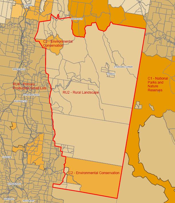
As shown earlier in Figure 4, there has been around 24,303ha increase in the lands included in a conservation zone. This increase is a result of:
• reviewing the application of the C1 National Park and Nature Reserves zone being applied to existing national parks, nature reserves and conservation areas established under the National Parks and Wildlife Act 1974. Several recently purchased sites were included in this zone. This review has been undertaken in consultation with the NSW National Parks and Wildlife Service
• the C2 Environmental Conservation zone being applied to significant conservation lands including land mapped as littoral rainforest or coastal wetland under State Environmental Planning Policy (Resilience and Hazards) 2021, land identified in local and/or site-specific studies containing Endangered Ecological Communities or Key Threatened Species
Habitat, culturally significant land, over-cleared vegetation communities and land subject to private conservation agreements in perpetuity
• the C3 Environmental Management zone being applied to riparian and estuarine vegetation and wetlands, Rare, Endangered and Vulnerable Forest Ecosystems, and native vegetation on coastal foreshores. In addition, this zone has been applied to aquifer footprints and in some areas where there are issues of high risk flooding,
• the C4 Environmental Living zone being applied to areas with a semi-rural lifestyle that are not generally used for agriculture. These areas often adjoin a National Park, have sensitive vegetation or waterways, contain significant bushland and have an outlook over the natural landscape. This zone has also been applied to paper subdivision areas in accordance with the Gateway Determination.
The draft MidCoast LEP contains several Additional Local Provisions (Part 7) aimed at protecting conservation lands and linkages such as:
• riparian land and watercourses – protect watercourses, their water quality and habitats
• protection of wildlife corridors – currently there are only a few corridors mapped, but this provision enables additional corridors to be added in the future where they are appropriately justified
• Karst topography – ensures development considers any risks to the karst topography.
The draft MidCoast Development Control Plan (referred to as the ‘draft MidCoast DCP’) will be prepared and will include provisions to protect certain types of vegetation and guide development near waterways and biodiversity land, which will support the draft MidCoast LEP.
3.3.2 Are there any other likely environmental effects of the planning proposal and how are they proposed to be managed?
The planning proposal will not result in any significant environmental effects. The draft MidCoast LEP proposes to apply a range of zones across the MidCoast to reflect the character and values of towns, villages and rural landscapes. Through this process there has only been minor adjustments to the residential footprint of the towns and villages. Any expansion of the residential footprint has addressed any potential impacts (e.g. flooding, contamination risks). In most cases the reduction of the residential footprint has been to address environmental effects (e.g. high velocity flooding). Changes proposed to the residential footprint are shown in Appendix 3
The Manning Health/Taree CBD Precinct Plan (refer to Appendix 14) contains the most significant changes to the urban form in the draft MidCoast LEP. This plan encourages health facilities around the Manning Base Hospital and encourages more people to live close to the Taree CBD. In some locations potential building heights have increased from 8.5m up to 21m. Extensive consultation was undertaken with the community to address any potential environmental, built form and amenity impacts.
As outlined in section 3.2.5 a range of environmental effects have been considered and addressed through the supporting documents (refer to Appendix 8-16).
The draft MidCoast LEP not only continues to draw upon the environmental planning controls within the three existing LEPs (e.g. acid sulfate soils, coastal risks, flooding, stormwater management, earthworks, bushfire hazard reduction) but also introduces new controls used in other areas of NSW to reduce environmental effects (e.g. development on steep lands, protection of rural landscapes, Karst topography).
The draft MidCoast DCP will be prepared and will include provisions to address any environmental effects from development, which will support the draft MidCoast LEP.
3.3.3 Has the planning proposal adequately addressed any social and economic effects?
The planning proposal is not expected to result in any significant negative social or economic impacts. The MidCoast is currently subject to housing affordability and availability stresses. The Housing Strategy (refer to Appendix 8) examined opportunities to encourage more housing close to town centres, facilities and services by applying the R1 General Residential, R3 Medium Density and R4 High Density Residential close to these centres, which have been incorporated into the draft MidCoast LEP. This is important given the MidCoast is home to an older population, with the median age of residents being 54 (NSW median age is 39). These zones will also provide accommodation for tourists who visit the MidCoast.
By applying the full range of residential zones available across the MidCoast, the character of towns and villages has been considered in more detail. The heritage provisions have also been reviewed to ensure a consistent approach across the MidCoast. In particular, a review of the Heritage Conservation Areas is underway, and after community consultation the findings of this review will be included in the draft MidCoast LEP.
The character of the towns and villages will be further identified through the draft MidCoast DCP
The Employment Zones Review (refer to Appendix 12) formed the basis of the application of the employment zones across the MidCoast. Through this review, it was identified that the extent of the employment zones around the Gloucester town centre was excessive and limited the development of the centre. The draft MidCoast LEP will reduce the extent of the Local Centre zone in this location. Other minor amendments were made to the employment zones based on this review.
The Rural Strategy – The Way Forward (refer to Appendix 9) and Rural Strategy – Supplementary Report (refer to Appendix 16), examined the rural zones in terms of facilitating rural uses and ancillary uses such as agritourism, that assist with the diversification and viability of the rural land.
The Manning Health/Taree CBD Precinct Plan (refer to Appendix 14) promotes the most significant changes to the urban form in the draft MidCoast LEP. This plan encourages health facilities around the Manning Base Hospital and encourages more people to live close to the Taree CBD. This plan aims to deliver more economic and residential opportunities for the Taree community.
Extensive consultation has been undertaken with the community on all of the above supporting documents. By ‘checking-in’ with the community with these documents, Council was made aware of any relevant social, economic, or environmental effects at this time. Community consultation on the draft MidCoast LEP was extensive providing opportunities for the community to find out more information and provide feedback. The Consultation Report (refer to Appendix 18-21) and Consultation Outcomes Report (refer to Appendix 22) provide details on the community consultation.
3.4 Section D – Infrastructure (local, State and Commonwealth)
3.4.1 Is there adequate public infrastructure for the planning proposal?
For the majority of the MidCoast, there are no additional public infrastructure implications or requirements with the planning proposal for the draft MidCoast LEP.
The exception is the area covered by the Manning Health/Taree CBD Precinct Plan (refer to Appendix 14) which promotes the most significant changes to the urban form in the draft MidCoast LEP. This plan encourages health facilities around the Manning Base Hospital and encourages more people to live close to the Taree CBD. This plan examined the infrastructure needs and included an implementation plan to address infrastructure such as road upgrades, parking options and park improvements. Network upgrades could be undertaken to support the additional growth. Work is being undertaken to prepare the development contribution plans for the MidCoast which will review the infrastructure needs and growth for this location.
3.5 Section E – State and Commonwealth interests
3.5.1 What are the views of State and Commonwealth public authorities and government agencies consulted in order to inform the Gateway Determination?
Consultation with relevant NSW Government Departments occurred throughout the development of the draft MidCoast LEP as outlined below
Strategy consultation (2020-2023)
Initial consultation occurred through the development of the supporting documents. Comments made by the NSW Government Departments are summarised in Zoning in Urban: Response to feedback (refer to Appendix 15) and the MidCoast Rural Strategy – The Way Forward (refer to Appendix 9).
Consultation was undertaken with relevant NSW Departments between June 2023 and January 2024. The NSW Departments consulted are listed below and a summary of the issues discussed is provided in Appendix 7.
NSW Government Department consultation Department of Planning and Environment:
• Hunter Regional Office
• Crown Lands
• Bush Fire Planning
• Biodiversity and Conservation Division
• Heritage NSW
• Water Group
• Forestry
Department of Primary Industries:
• Agriculture
• Fisheries
• Marine Parks
Department of Education
NSW Health
Forestry Corporation of NSW
NSW Aboriginal Land Council
Regional NSW – Mining Exploration and Geoscience
NSW Rural Fire Service
Through this consultation several changes have been made to the draft MidCoast LEP to address the NSW Government matters as summarised below. In addition, the Gateway Determination (refer to Appendix 2) was issued on 20 March 2024 and outlined NSW Government conditions, being amendments to the planning proposal
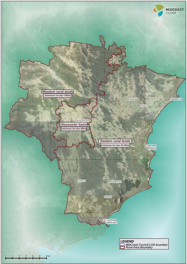
➢ Gloucester Basin rural lands – the application of rural zones in the MidCoast has been subject to several reviews. The draft MidCoast Rural Strategy released in 2021 proposed the use of one rural zone. This was the RU2 Rural Landscape zone with a minimum lot size of 40ha. The Department of Primary Industries (Agriculture) lodged an objection to this approach, in which they were concerned that the viability of agriculture would be compromised by the reduction of the minimum lot size from 100ha to 40ha and the use of one rural zone across a diverse rural landscape.
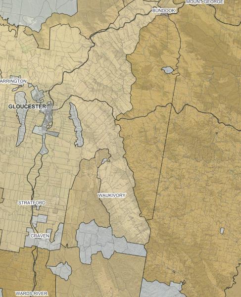
The MidCoast Rural Strategy – The Way Forward (refer to Appendix 9) was prepared and adopted by Council in December 2022. This document re-examined the rural lands, looking at the range of values applying to the land and proposing the use of three rural zones across the MidCoast as follows:
• Western rural lands – RU2 Rural Landscape zone
• Gloucester Basin – RU1 Primary Production zone
• Eastern rural lands – RU4 Primary Production Small Lots zone
Figure 5 provides the outcomes of this analysis.
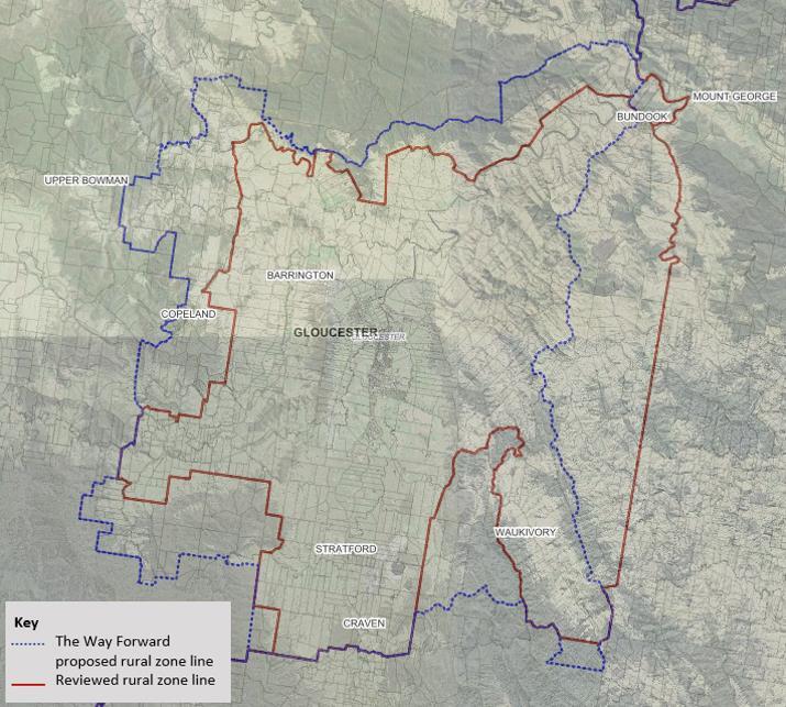
The Department of Primary Industries (Agriculture) opposed the changes proposed to the Gloucester Basin, given that the change from a minimum lot size of 100ha to 60ha had the potential to fragment the rural lands and reduce the viability of the land for rural activities.
An analysis of the subdivision potential of the Gloucester Basin was then undertaken. It was estimated that the number of potential lots was 560 additional lots. This was a desktop analysis, and it was recognised that not all these lots would come into fruition given the constraints of the land including steepness, ecological values, flooding and bushfire, along with the expense of providing infrastructure to the sites (e.g. roads, power, water).
To address the Department of Primary Industries (Agriculture) concerns, a review of the Gloucester Basin was undertaken in August 2023. The outcome of this review is shown in Figure 6. This map shows how the boundary of the Gloucester Basin has changed from the boundary proposed in the MidCoast Rural Strategy – The Way Forward (blue line) to a revised boundary (red line). Land to the north, west and south were included in the RU2 Rural Landscape zone with a minimum lot size of 100ha. These lands contained steep slopes and were often vegetated, being at the base of the hills around Gloucester. The eastern boundary was moved to the east to a similar alignment in the current LEPs. Much of this land contains sloping land which has been cleared. This extends the Gloucester Basin boundary to the east and includes the land in the RU1 Primary Production zone with a minimum lot size of 60ha.
Council considered the 60ha minimum lot size to be suitable for the Gloucester Basin. From northern NSW down to the Hunter Region, it is evident that a 40ha minimum lot size is consistently applied to coastal areas (east of the Great Divide) over viable agricultural lands. Application of the 60ha minimum lot size for the Gloucester Basin would address the fragmentation concerns raised by the Department of Primary Industries (Agriculture), enable a range of rural activities and is consistent with the neighbouring Dungog Shire Council rural minimum lot size of 60ha.
Figure 5: MidCoast Rural Strategy – The Way Forward application of rural zones
During this review, land south of the Gloucester Basin, around Terreel was identified as being steep land, well vegetated and contributed significantly to the biodiversity of the MidCoast, containing an important Koala population (refer to Figure 7 for the location). It is proposed to recognise these important values and include the land in the RU2 Rural Landscape zone with a 100ha minimum lot size. Landowners will be consulted on this proposed change during the consultation on the draft MidCoast LEP
During community consultation, a number of submissions sought clarity on the purpose of this zone change and implications. This has been addressed in Section 4.4.2 of the Consultation Report (refer to Appendix 18-21).
Figure 6: Gloucester Basin zone revised August 2023
The Gloucester Basin boundary (as shown in Figure 6) was incorporated into the draft MidCoast LEP considered by Council in October 2023. Further consultation with the Department of Primary Industries (Agriculture) identified that they were not satisfied with the rural provisions. The Rural Strategy – Supplementary Report November 2023 (refer to Appendix 16) was developed in response to issues. This report recommended a minor amendment to the eastern boundary of land included in the RU1 Primary Production zone
The Gateway Determination (refer to Appendix 2) supported the minor amendment to the eastern boundary of the Gloucester Basin as shown in Figure 8 (Condition 1(i)). The draft MidCoast LEP mapping has been amended to reflect this change
Figure 7: Location at Terreel to be included in the RU2 Rural Landscape zone
Figure 8: Amendment to eastern boundary of Gloucester Basin to be included in the RU1 Primary Production zone
➢ Potential flooding impacts – flooding is an important consideration for residential areas. An assessment was undertaken of the urban footprint for the towns and villages across the MidCoast, to identify locations where there is an intended extension of the urban footprint. These sites were then considered against the Probable Maximum Flood level (referred to as the PMF) When developing the draft MidCoast LEP, the flood planning areas were considered The Biodiversity and Conservation Division require the PMF to be considered which led to some sites being considered unsuitable for either a residential zone, or increased development controls (e.g. maximum building height) These changes have been provided in Appendix 7
➢ Port Stephens/Great Lakes Marine Park considerations – to ensure protection of the Marine Parks sanctuary zones and habitat protection zones, the W1 Natural Waterways zone will be applied over these Marine Park zones. The W1 Natural Waterways zone offers the highest level of protection and was being applied to Smiths Lake only in the MidCoast Rural Strategy – The Way Forward (refer to Appendix 9).
The draft MidCoast LEP was amended to extend this zone over waterways included in the Marine Park sanctuary and habitat protection zones at Allworth, Little Branch, North Arm Cove, Limeburners Creek, Bulahdelah River, Nerong, Number One Cove, Myall River and all remaining areas that overlap Marine Park sanctuary and habitat protection zones. These changes replace the direction for waterways zones outlined in the MidCoast Rural Strategy –The Way Forward (refer to Appendix 9).
Draft MidCoast LEP zones for Gloucester basin in October 2023
Draft MidCoast LEP zones for Gloucester basin in April 2024
RU4
RU4
RU4
RU4
RU4
The reference to the Marine Park Management Act 2014 has also been corrected in the draft MidCoast LEP.
➢ NSW Education School Infrastructure – NSW Education sites are included in zones that are applied to neighbouring properties. The Taree and Wingham High School Agricultural Plots were proposed to be included in the E4 General Industrial and C3 Environmental Management sites respectively. These zones are not listed as ‘prescribed zones’ under the State Environmental Planning Policy (Transport and Infrastructure) 2021, which is a requirement of NSW Education. As a result, these sites were included in the RU4 Primary Production Small Lots zone which is a prescribed zone and enables the continued use for the purpose of being an agricultural plot for the schools.
➢ NSW Department of Planning, Housing and Infrastructure – additional information and amendments were requested with regard to:
• the approach to paper subdivisions in terms of:
- the suitability of a conservation zone rather than a rural zone – as outlined in the Paper Subdivision Analysis Report (refer to Appendix 10) the paper subdivision sites are subject to a range of environmental and infrastructure constraints Given these constraints, the majority of the sites are not used or suitable for rural purposes. The significant point of difference between paper subdivisions and the adjoining rural land is the extent of fragmentation Some of these paper subdivision lots have a lot size as small as 400m2 and the paper subdivision locations can contain up to 3,500 lots This is why it is important that the development standards approach for paper subdivision reflects the range of environmental and infrastructure constraints.
By changing to a conservation zone, Council acknowledges that some form of housing may be allowed if the lot size is large enough to give regard to the environmental values and characteristics of the land. This also recognises that given the fragmentation and environmental values of these lands, they are not suitable for commercial agricultural uses.
- the application of the C3 Environmental Management and C4 Environmental Living zone over the paper subdivisions – a review was undertaken, and it is proposed to include all paper subdivisions in the C3 Environmental Management zone. A new objective will be included for the C3 Environmental Management zone to reflect the approach to paper subdivision sites, being “to ensure development considers and addresses natural hazards, risks and constraints” .
By applying one zone over the paper subdivision sites, it provides a consistent approach.
The C4 Environmental Living zone was not considered as a suitable zone. As per the Rural Strategy – The Way Forward (refer to Appendix 9), the C4 Environmental Living zone has been applied to specific locations where there are significant environmental considerations such as proximity to National Parks and to the lakes where environmental and water quality issues are significant.
The C3 Environmental Management was considered the most suitable zone. As per the Rural Strategy – The Way Forward (refer to Appendix 9), the C3 Environmental Management zone has been applied in locations where there are hazards, risks and constraints that need to be considered such as the high velocity flooding locations in Bulahdelah and Wingham and where buffers are
proposed to separate incompatible uses. The paper subdivision sites align with the application of the zone in the draft MidCoast LEP mapping
Where the site has significant wetlands identified under the State Environmental Planning Policy (Hazards and Resilience) 2021, these areas will continue to be included in the C2 Environmental Conservation zone.
- determine the appropriate minimum lot size for paper subdivisions – the minimum lot sizes were developed considering a range of factors as outlined in the Paper Subdivision Analysis Report (refer to Appendix 10). Many of these sites contain significant bushland or are located in proximity to the lakes, warranting strict controls to maintain water quality. Given each site is different and the environmental considerations significant, the application of minimum lot sizes needs to apply a cautionary approach. It should also be recognised that in many cases the proposed minimum lot size is well below the existing controls of 40ha. Council was working with the Department of Planning, Housing and Infrastructure to investigate whether a more consistent approach to minimum lot sizes could be developed
- clarify the purpose of clause 7.28 Lot consolidation – sites identified as consolidation sites typically have significant environmental constraints and involve less lots. It was also considered that the master plan exercise was unlikely to result in a suitable form of development. Council was working with the Department of Planning, Housing and Infrastructure to investigate whether changes to this clause would improve the intent and clarity of the clause.
The Department of Planning, Housing and Infrastructure reviewed this information and conditioned the Gateway Determination (refer to Appendix 2) to include all paper subdivisions in the C4 Environmental Living zone with a minimum lot size of 5ha (Condition 1(m)(i)). In addition, the paper subdivision clauses were consolidated into one clause (Condition 1(m)(ii)). The draft MidCoast LEP has been amended to reflect these Gateway Determination conditions.
• aligning the zone objectives with the Hunter Regional Plan 2041 – the objectives were reviewed, and minor changes made to use terminology from the Hunter Regional Plan 2041 In addition, Condition 1(a) the Gateway Determination (refer to Appendix 2) required the addition of rural aim in the draft MidCoast LEP.
➢ Land Use Table changes – several changes have been made, and these changes update the relevant land use tables outlined in the MidCoast Housing Strategy (refer to Appendix 8) and the Rural Strategy – The Way Forward (refer to Appendix 9). The changes included:
• C2 Environmental conservation zone – removal of ‘recreation facility (outdoor)’ as a permitted with consent use. The Biodiversity and Conservation Division was concerned that the extent of activities permitted within this land use was not consistent with the values of the zone. This land use has been replaced with ‘recreation area’ which would enable minor recreation uses ‘sewerage system’ was also removed as a permitted with consent use as required by Condition 1(l)(i) of the Gateway Determination (refer to Appendix 2)
• C3 Environmental Management and C4 Environmental Living zones – removal of ‘extractive industry’, ‘open cut mining’ and ‘mining’ as land uses that are permitted with consent. This change was made after discussions with the Biodiversity and Conservation Division and Regional NSW - Mining Exploration and Geoscience. It was
agreed that if any of these land uses were pursued in this zone, it would be through the State Environmental Planning Policy (Resources and Energy) 2021
• RE1 Public Recreation zone – the Gateway Determination (refer to Appendix 2) requires ‘environmental facility’ to be permitted with consent (Condition 1(l)(ii)). The use has been nominated as a ‘permitted without consent use’ and removes the need for this change
• RU1 Primary Production zone – removal of ‘car park’, ‘public administration building’, ‘vehicle body repair workshop’ and ‘vehicle repair station’ as land uses that are permitted with consent. These changes were made as a result of advice provided by the Department of Primary Industries (Agriculture) as they are not consistent with the values of the zone
• RU2 Rural Landscape zone – removal of ‘car park’, ‘place of public worship’, ‘vehicle body repair workshop’ and ‘vehicle repair station’ as land uses that are permitted with consent. These changes were made as a result of advice provided by the Department of Primary Industries (Agriculture) as they are not consistent with the values of the zone
• R1 General Residential zone – include ‘early education and care facility’, ‘take away food and drink premises’ as permitted with consent in this zone to be consistent with the requirements of the Hunter Regional Plan 2041 and Condition 1(l)(iii) of the Gateway Determination (refer to Appendix 2) Where a group term, some child terms were removed as a result of this change
• R2 Low Density Residential zone – include ‘early education and care facility’ and ‘take away food and drink premises’, ‘attached dwellings’ and ‘multi dwelling housing’ as permitted with consent in this zone to be consistent with the requirements of the Hunter Regional Plan 2041 and Condition 1(l)(iii) and (v) of the Gateway Determination (refer to Appendix 2) Where a group term, so some child terms were removed as a result of this change
• R3 Medium Density Residential zone – include ‘early education and care facility’ and ‘take away food and drink premises’ as permitted with consent in this zone to be consistent with the requirements of the Hunter Regional Plan 2041 (and Condition 1(l)(iii) of the Gateway Determination (refer to Appendix 2). Where a group term, so some child terms were removed as a result of this change
• R4 High Density Residential zone – include ‘early education and care facility’ and ‘take away food and drink premises’, and ‘neighbourhood supermarket’ as permitted with consent in this zone to be consistent with the requirements of the Hunter Regional Plan 2041 and Condition 1(l)(iii) and (iv) of the Gateway Determination (refer to Appendix 2) Where a group term, so some child terms were removed as a result of this change
➢ Gateway Determination conditions – in addition to the changes above, the Gateway Determination conditions (refer to Appendix 2) outline changes to be made prior to community consultation. Key changes included:
• removal of Part 4 clauses relating to ‘Minimum lot sizes for dual occupancies and manor homes’ and ‘Exception to minimum lot sizes for State Significant Agricultural Land’
• amendments to the objectives of the residential zones
• including a maximum building height for land included in the RE1 Public Recreation zone
• including floor space ratio requirements for buildings 26m or more
These changes were made to the draft MidCoast LEP for community consultation
Community consultation (April-July 2024)
Based on the requirements of the Gateway Determination and the previous consultation with NSW Government Departments, the following stakeholders were consulted.
NSW Government Departments
• Department of Primary Industries
• NSW Rural Fire Service
• Transport for NSW (TfNSW)
• Department of Climate Change, Energy, the Environment and Water
• Forestry NSW
• Forestry Corporation of NSW
• Heritage NSW
Local Aboriginal Land Councils
• Taree/Purfleet Local Aboriginal Land Council
• Forster Local Aboriginal Land Council
• National Parks and Wildlife Service
• NSW Environment Protection Authority
• Water NSW
• NSW Health
• NSW Department of Education
• Department of Regional NSW
• TAFE Infrastructure NSW
• Crown Lands
• Karuah Local Aboriginal Land Council
• Worimi Local Aboriginal Land Council
The feedback received from these Departments and the Local Aboriginal Land Councils is outlined in the Consultation Report - Appendix B (refer to Appendix 18 and 20). This feedback resulted in a number of proposed changes to the draft MidCoast LEP. In summary, these changes included:
• changes to the zoning of some properties under the ownership/management of the relevant NSW Government Department, Council infrastructure or Local Aboriginal Land Councils
• amendments to Schedule 5 to update State Heritage listed items and include items identified by National Parks and Wildlife Service
• Department of Climate Change, Energy, the Environment and Water requested that where the C4 Environmental Living zone was proposed to be applied to paper subdivisions that the minimum lot size be increased from 5ha to 10ha. Also, sewage systems be prohibited in the C2 Environmental Conservation zone
• exempt development provisions relating to bus shelters to be removed based on comments from Transport for NSW
• water supply systems be permitted with consent in the RU4 Primary Production Small Lots zone to address points raised by Water NSW
It is noted that discussions have been undertaken with the Forster Local Aboriginal Land Council, however they may seek additional information regarding the draft MidCoast LEP. If Council receives any further information from the Forster Local Aboriginal Land Council, this information will be provided to the Department of Planning, Housing and Infrastructure for their consideration.
PART 4: MAPS
PART 4 - MAPS
The three current LEPs were converted to digital online mapping prior to the community consultation
During community consultation, the draft MidCoast LEP mapping (listed below) was available on the planning portal and Council’s website
Draft MidCoast LEP maps
Land Application
Land Zoning
Lot Size
Height of Building
Land Reservation Acquisition
Heritage (heritage items, heritage conservation areas and archaeological)
Urban Release Areas
Acid Sulfate Soils
Coastal Risk Planning
Drinking Water Catchment
Groundwater Vulnerability
Protection of Wildlife Corridors
Foreshore Building Line
Active Street Frontages
Key Sites
Natural Resource – Karst
Landscape (steep land)
Paper Subdivision
Additional Permitted Uses
Council’s online mapping system identified the current LEP provisions and the proposed provisions for each site. Along with fact sheets, this online mapping provided the community with the information they needed to see how the LEP controls are proposed to be changed for their property and neighbourhoods.
The proposed changes to the draft MidCoast LEP mapping as a result of the community consultation are outlined in the Consultation Report (refer to Appendix 18-21).
With regard to the draft MidCoast LEP mapping:
• there have been cadastre changes made by the NSW Government since the mapping was developed. As a result, there are misalignments between the zone and property boundaries. Amendments will be required to the mapping to adjust zone boundaries, extent of development controls and specific clause mapping to align with the most recent cadastre
• some subdivisions have been finalised while the mapping has been developed, and minor adjustments are required to ensure that proposed zone boundaries align with the final subdivision boundaries
• where land has been incorporated into the C2 Environmental Conservation zone and is identified as Coastal wetland in the NSW Government’s State Environmental Planning Policy (Resilience and Hazards) 2021, the minimum lot size should consistently be 40ha. A mapping error has occurred in this circumstance and will be rectified. Not all of these sites have been mapped in the Consultation Report Appendix A (refer to Appendix 19).
These changes will be incorporated in the mapping for the draft MidCoast LEP
PART 5 - COMMUNITY CONSULTATION
Community consultation has been undertaken in the development of the supporting documents that provide the foundations for the draft MidCoast LEP. The community consultation undertaken is outlined in each of the supporting documents (refer to Appendix 8-16)
Community consultation on the planning proposal was undertaken in accordance with Section 3.34(2)(c) of the Environmental Planning and Assessment Act 1979, Council’s Community Engagement Strategy 2022-2025, the Gateway Determination and the Consultation Strategy that was reported to Council on 20 March 2024 (refer to Appendix 17)
The purpose of the community consultation undertaken from 29 April until 14 July 2024 was to build community understanding of the draft MidCoast LEP and seek community feedback.
There are two reports generated from this community consultation being:
• the Consultation Report (refer to Appendix18) outlines the community feedback provided during the community consultation process on the draft MidCoast LEP. The Consultation Report identifies issues raised through consultation, provides a response/discussion on the issues and where appropriate recommends changes to the draft MidCoast LEP in response to the feedback received. This report has three Appendices, being:
Appendix A – Site specific (refer to Appendix 19). The majority of feedback received was site specific, with the community providing comments about their property, adjacent properties and neighbourhoods. The issues raised, a response and any proposed changes to the draft MidCoast LEP are outlined in this Appendix
Appendix B – NSW Government and Local Aboriginal Land Council interests (refer to Appendix 20). The Gateway Determination specified which NSW Government Departments needed to be consulted, along with Local Aboriginal Land Councils. This part outlines the feedback provided by NSW Government Departments and Local Aboriginal Land Councils, and any proposed amendments to the draft MidCoast LEP
Appendix C – LEP Specific (refer to Appendix 21). A number of submissions were specific to the proposed zones, land uses or clauses in the draft MidCoast LEP. This Appendix addresses these submissions and provides details of the proposed amendments to the draft MidCoast LEP document
• the Consultation Outcomes Report (refer to Appendix 22) which outlines how the consultation was undertaken, the number of people who participated in the consultation and any feedback on the consultation process. This report considers whether the approach and objectives outlined in the draft MidCoast LEP Consultation Strategy have been addressed.
Figure 9 provides the community consultation snapshot which shows a summary of the community consultation processes undertaken.
Figure 9: Snapshot of the community consultation
PART 6: PROJECT TIMELINE
PART 6 - PROJECT TIMELINE
The following table outlines the tasks that are to be undertaken for this planning proposal and the estimated timeframes.
Given this is a comprehensive LEP and a major planning proposal, the delegation to make the plan will be the responsibility of the Department of Planning, Housing and Infrastructure