MIDCOAST RURAL STRATEGY


The Way Forward DECEMBER 2022
ACKNOWLEDGEMENT OF COUNTRY
We acknowledge the traditional custodians of the land on which we work and live, the Gathang-speaking people and pay our respects to all Aboriginal and Torres Strait Islander people who now reside in the MidCoast Council area. We extend our respect to elders past and present, and to all future cultural-knowledge holders.
MidCoast Rural Strategy – The Way Forward Page | 2 TABLE OF CONTENTS 1. INTRODUCTION 4 The ‘big picture’..................................................................................................................................6 The Way Forward ...............................................................................................................................8 2. WORKING WITH THE PLANNING SYSTEM 9 Local planning 10 Regional and State planning 10 3. OUR RURAL AREAS 12
rural zones...........................................................................................................................13 Draft Rural Strategy 16 Rural zone analysis 16
rural zones 24
rural zones planning controls 28 4. OUR CONSERVATION AREAS 29
conservation zones .............................................................................................................30 Draft Rural Strategy ..........................................................................................................................32 Conservation zone analysis ..............................................................................................................32
conservation zones 33
conservation zones planning controls 33 5. OUR WATERWAYS 35
waterways zones .................................................................................................................36 Draft Rural Strategy ..........................................................................................................................38
zone analysis .................................................................................................................38
waterways zones 38
waterways zones planning controls .................................................................................38 6. PAPER SUBDIVISIONS 40 Existing situation ..............................................................................................................................41 Draft Rural Strategy ..........................................................................................................................42 Paper subdivision analysis ................................................................................................................43 The Way Forward .............................................................................................................................43 7. DRINKING WATER AND AQUIFER CATCHMENTS 44
situation 45 Draft Rural Strategy 45
catchment analysis ..............................................................................................................47 The Way Forward .............................................................................................................................47 8. HIGH VELOCITY FLOODPLAINS 50
Existing
Proposed
Proposed
Existing
Proposed
Proposed
Existing
Waterways
Proposed
Proposed
Existing
Aquifer
Existing
MidCoast Rural Strategy – The Way Forward Page | 3
9. URBAN RELEASE AREAS
situation 51 Draft Rural Strategy 51 High velocity floodplain analysis 51 The Way Forward 52
53
10. VILLAGES
Existing situation 54 Draft Rural Strategy 54 Urban release area analysis 54 The Way Forward 54
55
..............................................................................................................................56
..........................................................................................................................56
.................................................................................................................................56
11. LARGE LOT RESIDENTIAL
Existing situation
Draft Rural Strategy
Village analysis
The Way Forward 57
58
..............................................................................................................................59
..........................................................................................................................59
............................................................................................................59
.............................................................................................................................59 12. DWELLING ENTITLEMENTS
Existing situation
Draft Rural Strategy
Large lot residential analysis
The Way Forward
61
..........................................................................................................62
.............................................................................................................................63 13. VISITOR ACCOMMODATION
Existing situation 62 Draft Rural Strategy 62 Dwelling entitlement analysis
The Way Forward
64
14. NEXT STEPS
APPENDIX A – OBJECTIVES AND LAND USE TABLES 69
Existing situation 65 Draft Rural Strategy 65 Visitor accommodation analysis 65 The Way Forward 66
67
INTRODUCTION

1
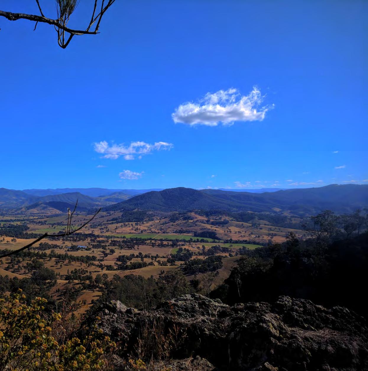
The MidCoast Rural Strategy applies across the rural and natural landscapes that surround our towns and villages.

The mixture of rural and natural landscapes (shown as light olive in Figure 1) are characterised by productive farmland, waterways, striking scenery and an abundance of natural treasures. Covering over 98% of the MidCoast Local Government area, the landscapes considered in the strategy comprise 74% rural lands, 24.5% environmental lands, 1.5% waterways and are home to approximately 5% of our population. For the purpose of the Rural Strategy we grouped these lands under the term ‘rural’.
Figure 1: The MidCoast centres, and rural and natural landscapes
Rural landscapes are a defining feature of the MidCoast - there is a diverse mix of communities, environments and opportunities. The rural and natural landscapes are covered by a variety of zones ranging from waterways zones to rural zones. Figure 2 shows how the lands in our conservation and rural zones transition to the residential zones that apply to our towns and villages, with the Large Lot Residential zone typically providing a buffer between the rural and urban landscapes.
These rural landscapes are experiencing change with pressure from growth, being a sought-after destination to visit or live, changing rural practices and recent natural disasters including drought, fire and flood. We have researched and reviewed our planning framework for rural lands, to meet these changing circumstances and keep what is important, all while ensuring the planning framework meets the communities needs and vision for the future wherever possible.
MidCoast Rural Strategy – The Way Forward Page | 5
The Rural Strategy provides a 20-year vision for planning for our rural and natural landscapes, to enable rural activities and conserve our natural environment. The Rural Strategy was based on technical information and engagement with the community, relevant industry groups and the NSW Government The Rural Strategy was also influenced by NSW Government policies that regulate what can be achieved in the rural landscape across NSW.
The ‘big picture’
We have undertaken extensive investigation into our rural lands, looking at the existing situation, NSW Government and industry trends and how we can maintain and ensure our rural lands remain productive and relevant into the future.
The draft MidCoast Rural Strategy and Overview released for community consultation in August 2021 proposed a new framework for our waterways, rural and natural landscapes, based on four goals:
These documents were supported by eleven background papers that delved into detail on the elements that make up rural lands. These draft reports (listed below) are available for viewing on Council’s website at https://haveyoursay.midcoast.nsw.gov.au/know-your-rural-zone
• Paper Subdivisions Analysis Report

• Marine Activities Report
• Rural Waterways Report
• Transport Report
• Mining and Energy Report
• Land Based Conservation Report
• Agriculture and Rural Industries Report
• Tourism Report
• Housing and Accommodation Report
• Environmental Living Zone Snapshot
• Primary Production Small Lots Zone Snapshot

MidCoast Rural Strategy – The Way Forward Page | 6
Conservation and Waterways zones
Rural zones Large Lot Residential zones
Residential zones
Figure 2: The MidCoast transition from rural and environmental landscapes to our towns and villages (Based on Rural-Urban Transect by Duany Plater-Zyberk and Company)
1.
2. Enhance
3. Protect
4.
Sustain primary production opportunities
rural lifestyles and livelihoods
natural landscapes
Improve planning and plan-making in practice
Our rural consultation
In preparing the Rural Strategy we discussed issues with stakeholders to understand the rural contexts. Interviews were undertaken with 59 businesses and six workshops with key stakeholders and relevant NSW Government agencies such as the Department of Primary Industries and Local Land Services. A community survey was undertaken during 2018. This information was referenced in the background papers, assisting to understand the issues faced by rural industries and communities.
The Rural Strategy and supporting documents were available for community feedback from 30 August 2021 until 28 January 2022. Given Covid-19 health restrictions, consultation included a 21/2 month extension and focussed on smaller information sessions, one-on-one meetings and phone calls/emails to respond to questions. In summary, the consultation involved:


• thirteen information sessions (including a Zoom session) attended by around 59 people
• 3,666 letters and 2,940 emails sent to landowners and interested community members
• 78 posters displaying information on the consultation and where to find more information
• 587 phone and 293 email enquiries with Council staff
• 11,833 visits to our ‘Know your Zone’ project page on Council’s website.
By the end of the consultation, we had received 431 submissions. The submissions were grouped as shown in Figure 3
MidCoast Rural Strategy – The Way Forward Page | 7
A significant number of submissions (279) related to the approach undertaken for paper subdivisions, followed by 6% of the submissions which related to the rural zones and lot sizes, 5% regarding the drinking water catchments and 5% on the application of the Environmental Living zone across the MidCoast. General rural issues raised in submissions have been grouped together and amount to 7% of the submissions.

The key issues raised in these submissions are dealt with through the sections 3 to 12 of this document.
The Way Forward
This document - the ‘MidCoast Rural Strategy – The Way Forward’ responds to the key issues raised during community consultation. It provides a clear approach for future planning controls based on evidence and in response to submissions.
The key planning controls are the land use zones, the minimum lot sizes for subdivision and maximum height of buildings, all of which are outlined in sections 3 to 5 of this document. Sections 6 to 12 provide details on planning controls for specific issues such as paper subdivisions, urban release areas, drinking water catchments and areas of high velocity flooding.
The planning controls outlined in this document will be progressed through the development of a new draft MidCoast Local Environmental Plan (LEP) and Development Control Plan (DCP). Once these plans are drafted, extensive community consultation will occur to ensure we again consider the views of the community.
The ‘MidCoast Rural Strategy – The Way Forward’ supports the rural documents completed to-date. It takes on-board issues raised by the community, NSW Government and stakeholders; it recommends what planning controls will apply and why; and details the next steps. It demonstrates how the Rural Strategy will transition into new planning controls for the MidCoast.
MidCoast Rural Strategy – The Way Forward Page | 8

2
WORKING WITH THE PLANNING SYSTEM
The planning system in NSW, supports an often complicated and multi-tiered range of local, regional and NSW Government requirements. The ‘MidCoast Rural Strategy – The Way Forward’ seeks to respond to and work within the current planning system as effectively as possible. To provide context, the current landuse planning system is outlined in this section.
Local planning
Currently, rural landscapes are dealt with differently under the three Local Environmental Plans (LEP) being:
• Gloucester Local Environmental Plan 2010
• Great Lakes Local Environmental Plan 2014
• Greater Taree Local Environmental Plan 2010
The rural landscape is made up of three different groupings of zones being rural, conservation and waterways zones. Each of the current Local Environmental Plans utilise these zones differently, meaning that MidCoast Council currently applies three different approaches to their planning for rural lands. This situation creates confusion in the community and results in inconsistent decisions being made depending on the location in which the development is proposed.
Regional and State planning
At the NSW Government level, there is also a wide range of planning activities that are occurring. Many of these impact on local controls and need to be considered in the context of using the suite of zones in any new LEP.
The Hunter Regional Plan 2041 provides overarching directions for future planning. The Regional Plan establishes Districts across the Hunter Region and outlines expectations for future development. The MidCoast is included in the Coastal District, east of The Pacific Highway, and the Barrington District to the west, incorporating part of Dungog Shire Council.
The NSW Government has also introduced a number of planning ‘reforms’ in recent times, including:
• the renaming of ‘environmental zones’ to ‘conservation zones’
• changes to employment zones with the existing Working Waterfront zone (currently an industrial zone) becoming a waterways zone
• the introduction of Agritourism as a new land use group term. It includes new uses being farm gate premises and farm experience premises. Existing land uses, being farm stay accommodation, cellar door premises and roadside stalls are also included within this reform. Two Local Environmental Plan clauses will assist with the implementation of Agritourism in the planning controls. These imminent changes have been included in this document.
The NSW Government also controls the ‘making’ of Local Environmental Plans through its Ministerial Directions and State Environmental Planning Policies (SEPPs). These give wide ranging direction on the outcomes that the NSW Government will accept in developing new or amending existing Local Environmental Plans. They need to be carefully considered throughout the process of developing the new draft MidCoast Local Environmental Plan in the future.
Another primary consideration is the NSW Government's Standard Instrument Local Environmental Plan often referred to as the ‘standard template’ approach to the creation of Local Environmental Plans. This template restricts the number of available rural, conservation and waterways zones to the following listed zones:
MidCoast Rural Strategy – The Way Forward Page | 10
Rural zones Conservation zones Waterway zones
Primary Production Rural Landscape Forestry Primary Production Small Lots Village Transition
National Parks and Nature Reserves Environmental Conservation Environmental Management Environmental Living
Natural Waterways Recreational Waterways Working Waterways Working Waterfront
How these suites of zones are to be used in the new draft MidCoast Local Environmental Plan is discussed in the following sections.
MidCoast Rural Strategy – The Way Forward Page | 11

OUR
3
RURAL AREAS
The MidCoast has a diverse agricultural sector. Our rural landscape supports a range of primary industries including beef, timber, poultry and dairy farming which produces 25% of NSW’s milk. Fishing and oyster farming are significant industries on our coast. There has been some growth in poultry industries as they relocate from the expanding edges of larger cities. Emerging rural industries such equine, wineries and horticulture are located throughout the MidCoast. Access to Sydney and Brisbane markets, accessibility to water and the tourist market, make the MidCoast an attractive location for rural industries and activities.
The diversity of rural industries and activities means that a ‘one size fits all’ approach to planning for the rural landscape is not suitable for the MidCoast.
Existing rural zones
While there are six zones that can be applied to rural lands, only five are considered in the ‘MidCoast Rural Strategy – The Way Forward’. The Village zone applies to small-scale urban areas and these settlements were addressed in the MidCoast Housing Strategy. There are some minor changes proposed to where the Village zone applies which are outlined in section 10.
Figure 4 shows how the rural zones are currently applied across the three Local Environmental Plans in the MidCoast and the location of the zones is shown in Figure 5. The Forestry zone is consistently applied across the three Local Environmental Plans as it applies to State-controlled land and privately owned land used for forestry. The Primary Production and Rural Landscape zones are very similar in their application, while the Primary Production Small Lots zone only applies to the Greater Taree Local Environmental Plan. The Transition zone is currently not used in any of the three Local Environmental Plans.
A key point of difference in the application of these zones is the minimum lot size which is shown in Figure 6. The former Gloucester Shire Council and areas to the north-west of Mount George, have a 100ha minimum lot size. The application of this minimum lot size needs to be reviewed to justify where it needs to be applied, rather than using a former Council boundary. The remainder of the rural zones are predominately 40ha, except for the Primary Production Small Lots zone which is in various locations in the former Greater Taree region, with a minimum lot size of 20ha and a rural site at Brimbin which has a minimum lot size of 300ha (created through a site specific rezoning).
The Gloucester basin includes the rural lands that surround the township of Gloucester. They are not shown on the zone map (refer to Figure 5) as they are currently in a conservation zone. This zone was used to retain low intensity agricultural uses like extensive agriculture, horticulture, viticulture and aquaculture
Production Rural Landscape
Forestry
Primary Production Small Lots Transition
NB. The Village zone applies across the MidCoast. Details are provided in the MidCoast Housing Strategy Figure 4: Current use of rural zones in the existing Local Environmental Plans
MidCoast Rural Strategy – The Way Forward Page | 13
Zones Greater Taree LEP Great Lakes LEP Gloucester LEP Primary


MidCoast Rural Strategy – The Way Forward Page | 14
Figure 5: The rural zones that currently apply across the MidCoast


MidCoast Rural Strategy – The Way Forward Page | 15
Figure 6: The minimum lot size that currently applies to rural zones across the MidCoast
Draft Rural Strategy
The draft Rural Strategy proposed applying the Forestry zone where forestry occurs and applying only one other rural zone across the MidCoast. The Rural Landscape zone was proposed with a minimum lot size of 40ha. The Rural Landscape zone was also applied over the Gloucester basin to reflect the rural use of the land.
During consultation, twenty-six submissions raised concerns regarding the proposed rural zones. The two key areas of concern were:
• reduction of the minimum lot size from 100ha to 40ha - concerns that this could lead to further subdivision of farmland, increasing the fragmentation of lots and impacting on the viability of agriculture or the environmental values and increasing the risk on biosecurity
• discontinuation of the Primary Production zone – concern about the ‘one-size-fits all’ approach being applied to the diverse rural landscape of the MidCoast.
Submissions were also received for specific sites. The Summary of Recommendations Report summarises the submissions, reviews the issues and outlines any proposed changes
The NSW Government submissions also reflected these concerns. Additional analysis has now been undertaken to respond to these issues.
Rural zone analysis
Regional review
A review of the rural planning controls in coastal NSW was undertaken. The North Coast Regional Plan 2036 identified ‘important farmland’, while the Illawarra-Shoalhaven Regional Plan 2041 identified ‘biophysical strategic agricultural land’. These mapping layers identify land that is often referred to as ‘good quality agricultural land’. These lands were examined in terms of the rural zones and the minimum lot sizes applied to see if there was a correlation in approach that should be considered for the MidCoast. Maps showing the location of the important agricultural lands, the zones and minimum lot sizes are provided in Figure 7 for the North Coast Regional Plan and Figure 8 for the Illawarra-Shoalhaven Regional Plan 2041.The key findings were:
1. No clear application of rural zones in each council area – for example, the use of Rural Landscape and Primary Production zones were interchangeable over both the North Coast and Illawarra-Shoalhaven regions. There was no clear pattern of the Primary Production zone being applied over the important agricultural land. The Primary Production Small Lots zone was applied in the Shoalhaven City Council Local Environmental Plan where it was used like a ‘rural residential’ zone with a minimum lot size of 2ha.
2. The minimum lot sizes varied – some patterns of application included:
• 20-40ha minimum lot sizes were applied to rural lands around settlements, in areas such as Lismore, Grafton, Casino, Kempsey, Dungog and Nowra
• the 100ha minimum lot size was used intermittently at the foothills of the ranges and between settlements, typically where the rural lands were not considered as significant high quality agricultural lands
• 60 and 70ha minimum lot sizes were evident inland of Dungog and Coffs Harbour where steeper lands were present. They were used as a transition to the rural lands that had a 100ha minimum lot size
MidCoast Rural Strategy – The Way Forward Page | 16

MidCoast Rural Strategy – The Way Forward Page | 17
Figure 7: Application of rural zones in the North Coast region

MidCoast Rural Strategy – The Way Forward Page | 18
Figure 8: Application of rural zones in the Illawarra-Shoalhaven region
Based on the analysis of rural lands in coastal NSW, it is proposed to:
• apply zones relevant to specific circumstances across the MidCoast, based on the following evidence-based analysis
• review the application of the 100ha minimum lot size around Gloucester to reflect the approach around towns and examine the use of a transition minimum lot size out to the western areas of the MidCoast.
Rural elements
Important agricultural land mapping is developed by the NSW Department of Primary Industries and is not available for the MidCoast. The Department of Primary Industries released draft State Significant Agricultural Mapping in November 2021. Council provided significant feedback on the mapping as it is not suitable for consideration in the ‘MidCoast Rural Strategy – The Way Forward’. The Department of Primary Industries acknowledge that improvements need to be made to this mapping, prior to finalisation and application across the MidCoast.
An analysis was therefore undertaken based on the data available across the MidCoast to identify the characteristics of rural lands, as follows:
1. Steep land (greater than 18% or 32 degrees)
Figure 9 shows the extent of steep land across the MidCoast, which has been grouped into three areas:
• Dominant steep lands – located to the north and west of Gloucester, most of this land is heavily constrained by slope. The river and creek valleys provide the relief from the steep slopes;
• Gloucester basin – surrounding the Gloucester township, the basin has lower lying hills that surround the Gloucester River
• mixed coastal landscape – there are ‘fingers’ of steep land that taper down to the coastal floodplains and wetlands.
2. Conservation and forestry lands
Figure 10 shows the location of conservation zones and the Forestry zone across the MidCoast. These lands are a mixture of privately and publicly owned land, which contain extensive vegetation and much of the biodiversity that the MidCoast is known for.
It is evident in Figure 10 that conservation and forestry lands are dominant in the western region of the MidCoast. These align with the western lands shown in Figure 9 and the aerial imagery in Figure 11, which shows the extent of vegetation in this area
The lands to the east are dominated by the rural zone, with the conservation and Forestry zones becoming more prevalent closer to the coast. The aerial imagery (Figure 11) shows that this area also has clusters of vegetation that are not always included in conservation zones.
A key exception is the conservation zone shown around Gloucester which includes the farmland within the Gloucester basin Under the ‘MidCoast Rural Strategy – The Way Forward’ these lands are proposed to be included in a rural zone to reflect the rural activities that occur in this area The aerial imagery in Figure 11 shows the extent of cleared land in the Gloucester basin that is used for rural activities that extend to the south.
MidCoast Rural Strategy – The Way Forward Page | 19


MidCoast Rural Strategy – The Way Forward Page | 20
Figure 9: Steep land (greater than 18% or 32 degrees)


MidCoast Rural Strategy – The Way Forward Page | 21
Figure 10: Conservation zones and the Forestry zoned land across the MidCoast


MidCoast Rural Strategy – The Way Forward Page | 22
Figure 11: Aerial imagery of the MidCoast

MidCoast Rural Strategy – The Way Forward Page | 23
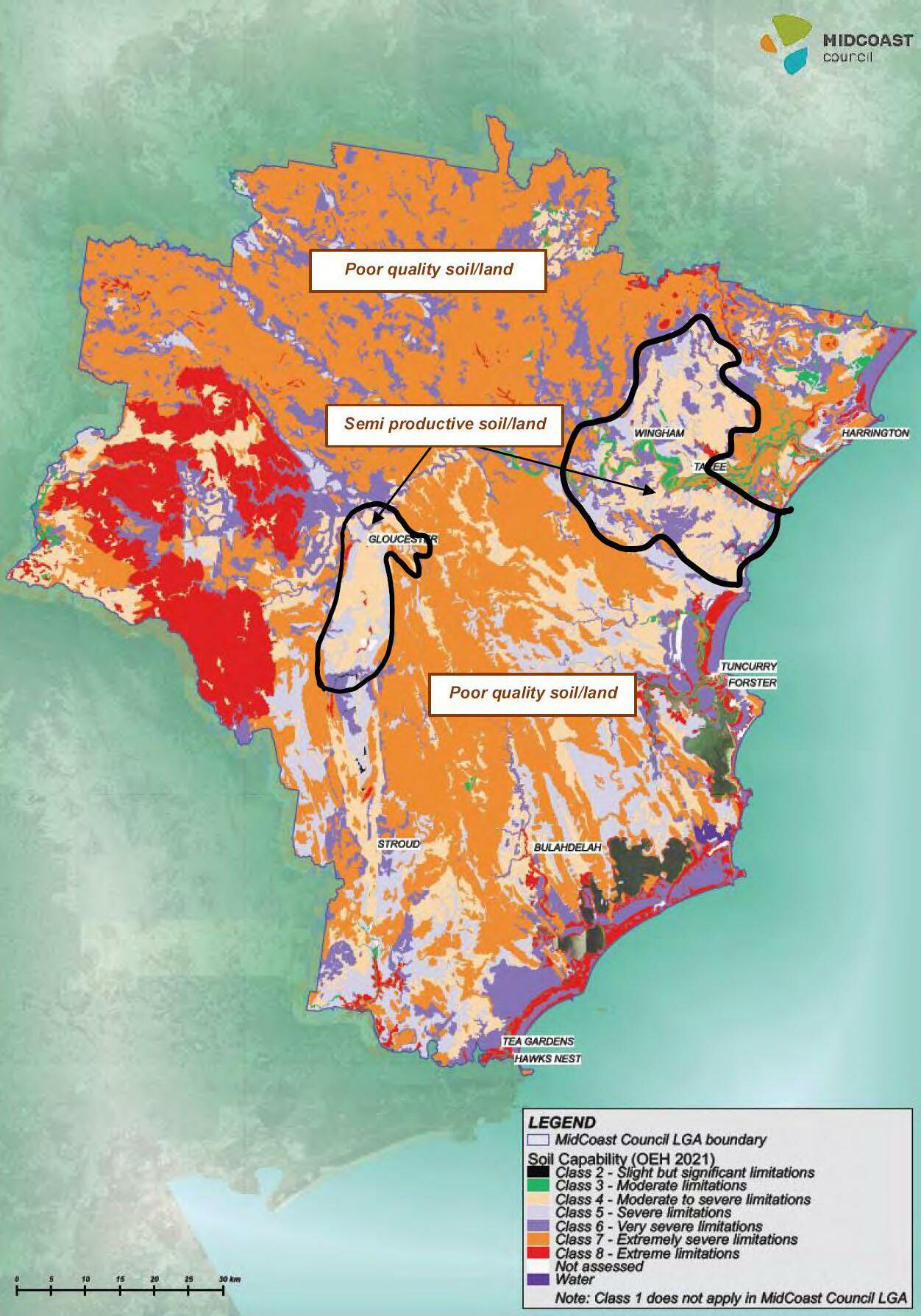
Figure 12: Soil land capability for the MidCoast (Source: OEH 2012)
3. Land and Soil capability
Given the absence of important agricultural land mapping from the Department of Primary Industries, land and soil capability mapping has been used. This mapping was developed by the NSW Government in 2012. The soil capability classes indicate the land management practices that can be applied to a parcel of land without causing degradation to the land and soil. The higher the classification the lower the capability of the land to undertake rural activities.
Figure 12 (above) shows the land and soil capability mapping for the MidCoast. It is important to note that there is no Class 1 soil identified in the MidCoast which are soils with very slight to negligible limitations, suitable for a range of rural activities
There are two clusters where Class 2 to 4 soils dominate, being the Gloucester basin and part of the Manning River catchment, representing some of the most productive rural lands for rural activities in the MidCoast
4. Lot fragmentation
Figure 13 shows the extent of lot fragmentation across the MidCoast.
Fragmentation occurred across the MidCoast, particularly between the 1980s to mid-1990s, enabled by Local Environmental Plans with clauses that encouraged concessional lots to enable the farmer to retire and still live on the land and to then pass the farm onto family members to run, or clauses that permitted the farmer to create additional lots to sell to help the farmer through rough times on the land.
While the idea of enabling farmers to remain on the land by permitting additional subdivision entitlements was well intentioned, it created lots below the minimum subdivision lot size and has led to the significant fragmentation of rural lands.
There is less fragmentation present in our western lands where lot size more closely aligns with the intention of the 100ha minimum lot size, moderate fragmentation is present in the Gloucester basin and high fragmentation is present in our coastal landscape.
Proposed rural zones
Based on the above rural analysis, the rural zones will be applied differently over the three areas as shown in Figure 14 and outlined below. The nominated boundaries relate to the physical features of the landscape. The western boundary generally aligns with the location of the conservation and forestry lands and the steep land mapping (refer to Figures 9 and 10). The eastern and southern boundaries are catchment boundaries for the Karuah and Avon water catchments, typically applying to the ridgelines
1. Western rural lands
Given the steepness of these lands and the poor quality of the soil, it is proposed to include this land in the Rural Landscape zone with a minimum lot size of 100ha. The range of rural activities currently permitted will be generally retained, along with the minimum lot size.
MidCoast Rural Strategy – The Way Forward Page | 24


MidCoast Rural Strategy – The Way Forward Page | 25
Figure 13: Rural lot fragmentation across the MidCoast

MidCoast Rural Strategy – The Way Forward Page | 26
Figure 14: The proposed rural areas
2. Gloucester basin

The Gloucester basin contains important agricultural land, with relatively good land and soil capability, less steep land (which has been typically cleared along the floodplain) and close proximity to the Gloucester township. Given the boundary follows catchment boundaries (ridgelines) to the east and south, there are some steep lands within the Gloucester basin, which are also well vegetated.
It is proposed to include this land in the Primary Production zone to enable the range of rural activities to continue. The minimum lot size is however proposed to be reduced from 100ha to 60ha to enable more rural activities close to the Gloucester township, which provides access to markets and services.
A combination of the conservation zone and 100ha minimum lot size has restricted opportunities for rural activities to establish in the Gloucester basin since 2010. The proposed changes to planning controls will provide the opportunity to improve the feasibility of rural activities in the Gloucester basin.
The review of rural lands along coastal NSW demonstrated the common application of a minimum lot size of 40ha around towns and the use of a transition lot size of 60-80ha leading up to the 100ha minimum lot size for these western rural lands. The application of the 60ha minimum lot size draws upon these findings.
An assessment of the potential for subdivision of this land indicates that the number of lots within this area may increase by around 18% or 320 lots. This potential increase in the number of lots is unlikely to be fully realised given:
• land to the east and south are constrained by steep lands, some of which are well vegetated
• some land adjoining the Barrington, Gloucester and Avon Rivers is subject to flooding.
3. Eastern rural lands

The eastern rural lands offer a diverse rural landscape, intermingled with steep lands, clusters of good vegetation and patches of land with a relatively good soil compatibility. There has been significant fragmentation of these lands prior to the mid 1990s when concessional lots and additional subdivision entitlements to farms were removed.
It is proposed to include this land in the Primary Production Small Lots zone, with the majority of land having a minimum lot size of 40ha. The 20ha minimum lot size will however be retained in locations around Wingham, The Bight, Tinonee, Mondrook, Krambach and Mitchells Island. The range of rural activities permitted in this zone will remain generally the same as those provided for in the existing rural zones.

MidCoast Rural Strategy – The Way Forward Page | 27
There are two locations where the minimum lot size will decrease from 100ha to 40ha (outlined in red in map above). Given the boundary between the Gloucester basin and eastern rural lands moves from being the former Council boundary to the water catchments, this land will be subject to a reduced minimum lot size of 40ha.
An assessment of the potential for subdivision of these lands indicates that the number of lots within this area have the potential to increase significantly (almost double). As shown by the underlying aerial, these lands are however steep and, in some cases, are well vegetated, reducing the likelihood that the further subdivision will occur. This is demonstrated by the lands directly to the east which have had a 40ha minimum lot size apply since the mid-1990s and subdivision has been minimal with lots being predominately 100ha+.
Proposed rural zones planning controls
The objectives and land use tables for the rural zones are provided in Appendix A. The rural zones will enable a range of rural activities and supporting uses such as agritourism. Several local provisions will provide guidance for development in rural lands. They will address:
• development on steep land
• intensive livestock agriculture
• aquaculture
• land use conflict related to subdivision
• rural and nature-based tourism
• farm gate and farm stay
• extractive resources
• renewable energy
• secondary dwellings and dual occupancies
• erection of houses on certain lands
• function centres
• land sharing communities
• eco-tourist facilities
• temporary use of land for functions and events
• recreation development
• biodiversity conservation
• protection of wildlife corridors
• riparian land and water courses
• development near zone boundaries
• emergency management
• tourist accommodation facilities and events
MidCoast Rural Strategy – The Way Forward Page | 28
CONSERVATION AREAS

4
The MidCoast is rich in natural treasures, from the stunning beaches and sea-cliffs, to the peaks of the Great Dividing Range, with pristine lakes and estuaries, unique and diverse plants and wildlife. Protection of our natural environment has been identified as one of five key values in the MidCoast Community Strategic Plan. In recognition of this, placing the region’s biodiversity and ecological health at the forefront of our planning framework is crucial.
Existing conservation zones
There are four zones that can be applied to conservation areas. Figure 15 shows how the conservation zones are currently applied across the three Local Environmental Plans in the MidCoast and the current location of the zones is shown in Figure 16.
The National Parks and Nature Reserves zone is consistently applied across the three Local Environmental Plans as it applies to existing National Parks and Nature Reserves owned and managed by the NSW Government.
Across the three Local Environmental Plans the Environmental Conservation zone has typically been applied to land that has high ecological, scientific, cultural or aesthetic values outside the National Parks and Nature Reserve system. This includes littoral rainforests, coastal wetlands, vegetation listed as an endangered ecological community, biodiversity conservation areas along with the significant corridors that link them.
The Environmental Management zone has also been applied consistently across the three Local Environmental Plans, being land with special ecological, scientific, cultural or aesthetic values. This includes land in sensitive coastal environments, our vegetated steep lands, and land fronting rivers or lakes which provide important environmental corridors to these natural landscapes.
A key point of difference in the application of these zones is the Environmental Living zone. This zone is intended for land with special environmental or scenic values and accommodates low impact residential development. The Greater Taree Local Environmental Plan 2010 restricts the zone to an isolated pocket of land at Brimbin for a community title use. In the Great Lakes Local Environmental Plan 2014 it is used in discrete locations along the western foreshore of Wallis Lake from Whoota to Coomba Park, and Blueys Beach.
Zones Greater Taree LEP Great Lakes LEP Gloucester LEP National Parks and Nature Reserves Environmental Conservation Environmental Management
Environmental Living
Figure 15: Current use of conservation zones in the existing Local Environmental Plans
MidCoast Rural Strategy – The Way Forward Page | 30


MidCoast Rural Strategy – The Way Forward Page | 31
Figure 16: The conservation zones and Forestry zoned land that currently apply across the MidCoast
Draft Rural Strategy
The Rural Strategy generally applied the conservation zones across the MidCoast as they are currently used. Based on updated technical information the conservation zones may be applied over new sites in the Rural Strategy, reflecting the environmental values of the property. For example, a conservation agreement may have been entered into to protect a property in perpetuity, or the site contains a significant threatened species, or the NSW Government has purchased land to extend a National Park
The exception was the Environmental Living zone – which was extended over a larger area of the MidCoast. Properties currently in this zone adjoin the lakes, have a semi-rural lifestyle and have a minimum lot size of 10ha which will remain. The new properties are currently in a rural zone but are not typically used for agriculture. They adjoin a National Park, have sensitive vegetation or waterways and often contain bushland, are home to fauna and have an outlook over the natural landscape. They are ‘lifestyle’ lots nestled amongst the natural landscape, not intended for a range of rural activities. The minimum lot size for this zone was reduced from 40ha to 20ha, to reflect the existing lot sizes found in these locations
The conservation zones were also applied to address specific land use issues. Refer to the relevant sections below to find out more
• Section 6 -Paper subdivisions
• Section 7 - Drinking water and aquifer catchments
• Section 8 - High velocity floodplains
• Section 9 - Urban release areas
Feedback received during consultation, has been grouped as follows:
• concerns about the application of the Environmental Living zone over the new locations
• requests for horticulture, secondary dwellings, dual occupancies and primitive camping to be permitted in the Environmental Management and Environmental Living zones
• concern about industries establishing in the conservation zones
• protection of identified karst environments (limestone) in the Gloucester region
• the NSW Government seeking clarification on the proposed use of the conservation zones.
Submissions were also received for specific sites. The Summary of Recommendations Report summarises the submissions, reviews the issue and outlines any proposed changes.
Conservation zone analysis
The application of the Environmental Living zone over the new locations has been reviewed. These locations display natural landscape qualities rather than rural landscape qualities, justifying the application of this zone. While the reduced minimum lot size from 40ha to 20ha may enable some additional lots to be created, the environmental qualities of the site would have to be considered in the assessment of a subdivision application. The minimum lot size of 10ha will be retained over the existing Environmental Living zoned properties that provide a semi-rural lifestyle generally located around the Wallis Lake
Karst environments are limestone formations that have been identified in the Gloucester region in previous planning controls. Research has identified the location of these formations, which can be a constraint to development. It is proposed to map the location of the karst environments in the MidCoast Local Environmental Plan and provide a local planning provision outlining the development requirements.
MidCoast Rural Strategy – The Way Forward Page | 32
Some changes are proposed to the conservation zone land use tables to broaden the range of activities proposed in the zones, as follows:
• horticulture enables cultivation of plants (including flowers, mushrooms, fruits, vegetables, nuts and foliage) for commercial purposes. This rural use will be permitted with consent in the Environmental Management and Environmental Living zones
• dual occupancies will be permitted with consent in the Environmental Living and Environmental Management zones to address housing issues raised in submissions. Site constraints and design will still be considered through the development application process to ensure that it fits in with the natural landscape. Secondary dwellings will not be permitted, given they are a form of additional housing which can be approved as a dual occupancy
• primitive camping will also be permitted with consent where siting and design is adequately considered
• information and education facilities and cellar door premises are appropriate uses for the Environmental Living zone and have been included as uses permitted with consent in this zone
• industrial activities will be excluded wherever possible from conservation zones, and home industries have been listed as a use that is permitted with consent in the Environmental Management and Environmental Living zones
Throughout the MidCoast there are numerous properties that have recognised environmental values through an agreement. Conservation agreements provide a financial contribution to landowners for the conservation of their land in perpetuity. Also, through a development approval some sites have conservation restrictions applied over their property identified on their land title (referred to as a section 88B restriction). In these circumstances, the environmental significance has been identified with the landowners and an Environmental Conservation zone could be applied. More work will be undertaken to identify these sites prior to the finalisation of the draft MidCoast Local Environmental Plan
The NSW Government will also be consulted on the draft MidCoast Local Environmental Plan to ensure the conservation zones meet their requirements.
Proposed conservation zones
The most significant changes to the application of conservation zones are as a result of recommendations in section 7 and 9 relating to drinking water catchments and urban release areas. Figure 17 reflects these changes, indicating the proposed location of the conservation zones across the MidCoast. Some additional changes may arise from the research identified above, where sites committed to conservation through an agreement are identified. Landowners will be notified of these changes through the draft MidCoast Local Environmental Plan consultation.
Proposed conservation zones planning controls
The objectives and land use tables for the conservation zones are provided in Appendix A and reflect the changes raised through submissions
Several local provisions will provide guidance for development on conservation zoned land as outlined below. Many of the rural zone clauses will be also be applied to the conservation zones.
• dual occupancies in the conservation zones
• environmental corridors
• identification of karst (limestone) environments
MidCoast Rural Strategy – The Way Forward Page | 33


MidCoast
Strategy – The Way Forward Page | 34
Rural
Figure 17: The proposed conservation zones and Forestry zoned land for the draft MidCoast Local Environmental Plan

OUR WATERWAYS 5
The MidCoast is characterised by pristine waterways, striking scenery and an abundance of natural features. Our lands are provided with water by 38 rivers and a triple lake system. We also enjoy 192 kilometres of pristine coastline Our waterways play an integral role not only in our region’s environmental health but also its economic, cultural and social wellbeing.
Existing waterways zones
There are four zones that can be applied to waterways being the Natural Waterways, Recreational Waterways, Working Waterways and working Waterfront zones. Figure 18 shows how the waterway zones are currently applied across the three Local Environmental Plans in the MidCoast and the location of the zones is shown in Figure 19.
The Gloucester Local Environmental Plan 2010 does not use these zones and has been excluded from Figure 19. Given the environmental significance of the lakes, the Natural Waterways zone was used in the Great Lakes Local Environmental Plan 2014, alongside the Recreational Waterways zone in Wallis Lake and Myall River. While the Greater Taree Local Environmental Plan 2010 applied the Recreational Waterways zone to all tidal waterways, with Crowdy Bay Harbour being the exception, recognised as a Working Waterways.
Recently, NSW Government reforms for employment zones, moved the Working Waterfront zone from being an industrial zone to a waterways zone. This zone is applied over the land adjoining waterways and enables activities associated with the waterway. The Working Waterfront zone is currently used in both the Greater Taree Local Environmental Plan 2010 and Great Lakes Local Environmental Plan 2014 at Crowdy Head, Forster, Tuncurry and Tea Gardens.
Across the MidCoast, the waterway zones have been used differently but overall, there has been only minor differences in the objectives and the types of land uses permitted.
Natural Waterways
Recreational Waterways Working Waterways Working Waterfront
Figure 18: Current use of waterways zones in the existing Local Environmental Plans
MidCoast Rural Strategy – The Way Forward Page | 36
Zones Greater Taree LEP Great Lakes LEP Gloucester LEP

MidCoast Rural Strategy – The Way Forward Page | 37
Figure 19: The waterways zones that currently apply across the MidCoast
Draft Rural Strategy
Waterways in the MidCoast are under the care, control and management of the NSW Government.
The MidCoast waterways were reviewed in terms of their environmental sensitivity and how they are used. The Natural Waterways zone was applied where an area is environmentally sensitive, like Smiths Lake. The uses permitted in the zone reflect how we use the lake, enabling low-impact recreational uses such as fishing, boating and commercial fishing industries.
The Working Waterways zone was applied to Crowdy Head Harbour and Cape Hawke Harbour (from the entrance to the Forster-Tuncurry bridge) to reflect their commercial activities. These harbours are known for their fishing, diving or whale watching tours, the hiring or repair of boats and other tourist activities. This zone enables marine based activities and industries in these locations.
The Recreational Waterways zone was commonly applied to our coastal waterways, allowing greater flexibility for water-based recreation, boating, water transport and development associated with fishing industries (e.g. water-based aquaculture and recreational fishing).
Two submissions were received on waterway zones, with the key points being:
• request to change Nerong Harbour zone from a Recreational Waterways to a Natural Waterways zone
• support for the use of the Natural Waterways zone around Smiths Lake.
Waterways zone analysis
An analysis of these two submissions was undertaken. The Nerong Harbour submission requested that the Natural Waterways zone be applied to the Nerong Harbour, consistent with the current zone in the Great Lakes Local Environmental Plan 2014 This harbour is located within an environmentally sensitive location and the Natural Waterways zone is appropriate. This zone change will be reflected in the draft MidCoast Local Environmental Plan
Support for the proposed application of the Natural Waterways zone for Smiths Lake was noted.
Proposed waterways zones
The proposed waterways zones for the draft MidCoast Local Environmental Plan have been amended to include Nerong Harbour in the Natural Waterways zone (refer to Figure 20).
Proposed waterways zones planning controls
The objectives and land use tables for the waterways zones are provided in Appendix A.
Some local provisions will provide guidance for development in waterways. In summary they will cover riparian land and water courses.
MidCoast Rural Strategy – The Way Forward Page | 38


MidCoast Rural Strategy – The Way Forward Page | 39
Figure 20: The proposed waterways zones for the draft MidCoast Local Environmental Plan

PAPER SUBDIVISIONS 6
Existing situation
Paper subdivisions were approved in the late 1800s or early 1900s While the rural lots were created, the surveyed estates with houses, roads and services have not been realised as the planning controls have changed over time. Most of these lots have no dwelling entitlement, meaning houses cannot be constructed on the lots.
Paper subdivisions are found in various locations including North Arm Cove, Pindimar, Bundabah, Carrington, Krambach and the former gold mining town of Copeland. North Arm Cove is the largest paper subdivision, designed by Walter Burley Griffin and approved in 1918. It was originally under consideration as the national capital, given its access to Port Stephens and its potential as a naval base Figure 21 shows many of the paper subdivisions adjoining Port Stephens
Figure 21: Paper Subdivisions adjoining Port Stephens Bay


Paper subdivisions often have significant environmental and servicing constraints, limiting their opportunity for development. Despite these constraints, Council is required under the Local Government Act 1993 to levy rates on this land.
Some families have owned these properties for several decades and have had the ongoing financial costs of paying rates for a lot which cannot be built upon Some people continue to buy these constrained properties with no dwelling entitlement, whether for occasional camping use or in the hope that the planning rules will change in the future permitting a house to be erected In some cases, landowners have relinquished their property to Council in lieu of unpaid rates and charges.
Through the Rural Strategy and Paper Subdivisions Analysis Report, Council provided clarity on the constraints applying to these paper subdivisions and outlined options available to landowners.
Currently paper subdivisions are typically included in a rural zone with a minimum lot size ranging from 40ha to 100ha.
MidCoast Rural Strategy – The Way Forward Page | 41
Draft Rural Strategy
The Paper Subdivision Analysis Report is a background paper to the Rural Strategy. It examined the paper subdivision areas in terms of:
• relevant State, regional and local planning controls
• the historic extent of the paper subdivisions
• constraints of each paper subdivision
• proposed zones and planning controls for consideration in the draft MidCoast Local Environmental Plan
• options for landowners to retain their land, transfer land to Council or pursue a Development Plan and Subdivision Order
The Paper Subdivision Analysis Report identified major environmental and infrastructure constraints associated with the paper subdivisions and recommended they be included in conservation zones to more appropriately reflect the values of the land. The report also identified the minimum lot size that should be applied to the locations. In many cases this was less than the existing 40ha minimum lot size, providing landowners with the opportunity to consolidate lots to enable a dwelling entitlement. Given many of the lots were under 1,000m2, it was recognised that it was still difficult to consolidate enough lots to achieve this outcome. The changes proposed in the Rural Strategy and Paper Subdivisions Analysis Report are outlined in Table 1 below.
Table 1. Paper subdivision constraint analysis and recommendations (extract from the Paper Subdivision Analysis Report) Location Constraint level Proposed zone Proposed minimum lot size
Bundabah Moderate Environmental Living 10ha Carrington High Environmental Management 10ha Coolongolook Moderate-High Environmental Living 10ha Copeland/Copeland Common High Primary Production 60ha Hamilton High Environmental Management 40ha Krambach Moderate Environmental Living 10ha Limekilns High Environmental Management 40ha North Arm Cove Moderate-High Environmental Management 20ha Pindimar High Environmental Management 40ha
The Branch High Environmental Management Environmental Living where lots have existing dwellings with suitable access
40ha 10ha
Wingham North Moderate Environmental Management 10ha
Note: Paper subdivision lots affected by coastal wetlands to be included in Environmental Conservation zone
All paper subdivision landowners were notified by mail about the Paper Subdivision Analysis Report and feedback was sought. Of the 431 submissions received during the exhibition period, 65% were from landowners of lots in the paper subdivisions. The majority opposed the proposal to include the land in a conservation zone, as it would prevent the possibility of urban development. Other key issues related to:
• concerns about the consultation process
MidCoast Rural Strategy – The Way Forward Page | 42
• application of rates to paper subdivisions
• support for a development outcome
• support for camping - requests for additional information
• services, facilities and enforcement
• support for the application of conservation zones or a request for an alternative conservation zone
• recognition of heritage significance.
Paper subdivision analysis
The paper subdivision submissions were reviewed and reported to Council on 28 September 2022, which recommended:
• the Paper Subdivision Analysis Report be amended as follows:
- reflect any new planning guidelines or policies
- identify key constraints and legislative requirements for each location, to provide additional context for landowners willing to fund the studies, investigations and master planning required to follow the NSW Government’s Paper Subdivision Guidelines. In particular, include publicly available information from the Biodiversity Values Map and BioNet Threatened Species database (flora and fauna information) in the report
- acknowledge the heritage significance of the subdivision layout for North Arm Cove and require any future subdivision to acknowledge this subdivision design
- include a form to enable contact between adjoining landowners to discuss the sale or purchase of land or to pursue the NSW Government’s Paper Subdivision Guidelines
• the following be included in the draft MidCoast Local Environmental Plan:
- a draft local provision that requires all lots that form an existing holding be consolidated to enable development approval for a dwelling. This may be required as a form of deferred development consent
- a change to the Environmental Management zone objective to be “To conserve biological diversity and native vegetation corridors, and their scenic qualities, in a rural setting” to reflect that when the zone is used in paper subdivision locations the land is not considered to have a rural setting
• Council’s website be updated to include the amended Paper Subdivision Analysis Report and provide additional information on camping and associated activities in paper subdivisions to ensure all relevant information is available to landowners.
The Way Forward
The proposed zone and minimum lot size changes outlined in Table 1 are to be included in the draft MidCoast Local Environmental Plan as endorsed by Council on 28 September 2022 The objectives and land use tables for these zones are provided in Appendix A.
Local provisions are proposed in the draft MidCoast Local Environmental Plan which are to:
• outline exceptions to development standards – minimum lot sizes and paper subdivisions
• enable lot consolidation within identified paper subdivisions in conservation zones
• outline the Master Planning process on land within identified paper subdivisions
MidCoast Rural Strategy – The Way Forward Page | 43

DRINKING WATER AND AQUIFER CATCHMENTS 7
Existing situation
The MidCoast experienced its worst drought on record throughout 2019 and early 2020. This unprecedented event, combined with the ‘Black Summer’ bushfire crisis, resulted in the development of a drought response strategy. This strategy aimed to reduce water use across the MidCoast, while ensuring the community could access potable drinking water supplies. Measures included water restrictions, community education, increased use of recycled water, water carting to our most affected townships and fast-tracking key projects such as the Nabiac Borefield expansion.
Drinking water in the MidCoast is sourced from both terrestrial (above ground rivers and streams –referred to as drinking water catchments) and subterranean (aquifer groundwater – referred to as aquifer catchments) systems.
Currently, drinking water catchments in the MidCoast are only identified in the Great Lakes Local Environmental Plan 2014 in terms of being mapped and having a specific local provision in the Local Environmental Plan.
Draft Rural Strategy
The draft Rural Strategy investigated how the planning framework could assist with ensuring water security in the region. Identifying both the drinking water catchments and aquifer catchments in the draft MidCoast Local Environmental Plan would ensure that future developments do not compromise these significant water resources.
The drinking water catchments and aquifer catchments are mapped as shown in Figure 22.
1. Drinking water catchments
The catchments shown in Figure 22 are proposed to be included as an overlay in the draft MidCoast Local Environmental Plan. If development is proposed on land within these catchments it needs to demonstrate that the proposed use of the land will not impact on the quality of the water entering the drinking water catchment. A local planning provision used in Local Environmental Plans across NSW for drinking water catchments will apply to these locations.
2. Aquifer catchments
The aquifers are an important source of water and require a similar level of protection as the drinking water catchments. There are two layers to the aquifers as shown in Figure 22:
• the aquifer footprint where water is drawn directly from the aquifer
• the aquifer catchment where water from these sites adds to the aquifer
In both the aquifer footprint and catchment, the draft Rural Strategy proposed including land in the Environmental Management zone. The aim being to reduce the ability for uses to occur in this location which could potentially reduce the water quality of the aquifers like feed lots or poultry farms.
An overlay in the draft MidCoast Local Environmental Plan was proposed for the aquifers alongside a local planning provision that ensures water quality is considered for any development proposed within the aquifer catchment.
MidCoast Rural Strategy – The Way Forward Page | 45
Figure 22. Drinking Water Catchments and Aquifer Catchments in the MidCoast


Given the proposed zone change for properties in the aquifer catchments, letters were sent to all affected landowners seeking their feedback. Twenty-one submissions were received regarding the aquifer catchment. The key issue was the change from a rural to a conservation zone with regard to:
• not complying with the NSW Government’s guidelines for applying conservation zones
• being inequitable - landowners affected are not provided with town water or sewer connections that would provide additional protection to the same water supply
• impact on property values
• restricting rural activities that would become prohibited in the conservation zone

• impacting on activities such as noxious weed control and bushfire hazard reduction measures, feral animal control and firewood collection
• being contradictory to uses such as the proposed landfill and the existing sand quarry, motor cross track, business equipment storage and holiday accommodation that would become prohibited
• the accuracy of the catchment boundary
• disparity between drinking water catchments (no zone change) and aquifer catchments.
MidCoast Rural Strategy – The Way Forward Page | 46
Aquifer catchment analysis
There is no clear approach for dealing with aquifers across NSW in Local Environmental Plans. The changing of the zones would provide a clear indication of the importance of the aquifer footprint and catchment, ensuring the protection of the water quality of the aquifer. Reviewing the submissions, it was made clear that the zone change had numerous impacts on landowners. A review of options was undertaken, and the following approach is proposed to address the submissions, while still providing a level of protection for the water quality of the aquifers:
• land in a rural zone in the aquifer footprint is to be included in the Environmental Management zone (except where changes are proposed given the environmental values of the land – refer to section 4). A review of the boundary of the footprint was undertaken with Council’s Water Services Department to ensure the accuracy of the footprint
• the aquifer catchment is to remain in a rural zone – no change to a conservation zone is proposed (except where changes are proposed given the environmental values of the land –refer to section 4)
• an overlay will be applied to both the aquifer footprint and catchment which will be included in the draft MidCoast Local Environmental Plan. This overlay will be accompanied by a local provision which ensures any new development does not impact on the quality of water entering the aquifer. This is the same process applied to the drinking water catchments.
The Way Forward
The drinking water catchment overlays are to be included in the draft MidCoast Local Environmental Plan as shown in Figure 22.
Rural zoned land in the aquifer footprints are to be included in the Environmental Management zone and an overlay provided over the aquifer catchments in accordance with Figure 23 and Figure 24 The objectives and land use tables for the Environmental Management zone are provided in Appendix A.
Local provisions are proposed to the draft MidCoast Local Environmental Plan which outline requirements for drinking water catchments and requirements for aquifer catchments
MidCoast Rural Strategy – The Way Forward Page | 47

MidCoast Rural Strategy – The Way Forward Page | 48
Figure 23. Application of the aquifer catchments and footprint at Nabiac in the draft MidCoast Local Environmental Plan

MidCoast Rural Strategy – The Way Forward Page | 49
Figure 24. Application of the aquifer catchments and footprint at Tea Gardens in the draft MidCoast Local Environmental Plan

8
HIGH VELOCITY FLOODPLAINS
Existing situation
The MidCoast has experienced significant flooding over the last two years, along with large areas of NSW, prompting changes to how we deal with flood prone land. While the NSW Government is still developing new flood controls, there are residential locations in the MidCoast known to be in high velocity floodplains. These locations and their current zones are outlined below:
• western parts of Bulahdelah – Village zone
• land surrounding Wingham – the Primary Production zone
• Gloucester town centre – Environmental Management zone.
Enquiries for more housing in these locations are regularly received and are not supported given the high velocity flooding experienced in these locations.
Draft Rural Strategy
The draft Rural Strategy proposed to include the above locations in the Environmental Management zone given they are affected by hazardous environmental processes namely flooding. The aim being to clearly identify the flood risk for any future housing applications in these hazardous locations Figure 25 shows the extent of land being included in the Environmental Management zone given the high velocity flood risk.
Letters were sent to all affected landowners seeking their feedback. Five submissions were received, some against and some in support of the proposed Environmental Management zone over these lands. The key issues related to the change from a rural to a conservation zone are:
• the loss of existing use rights or dwelling entitlements
• the change in permissible uses and no compensation for ‘back-zoning’
• inconsistent approach to flood prone lands (e.g. Oxley Island subject to flooding but no zone change is proposed)
• the extent of the actual flood area compared to the rezoned area
• the effect on insurance premiums.
High velocity floodplain analysis
NSW Government planning requirements for flood prone lands will evolve over the next few years, given the recent flooding events across NSW. The draft Rural Strategy applied flooding provisions over the land identified below as they are known to experience high velocity flooding and we receive regular enquiries for additional housing to be established in these locations. The zone change does not change the flood prone status of land, it highlights the existing flood risk.
While it is acknowledged that other areas experience flooding, future NSW Government controls will identify the constraints and the approach to be undertaken. The draft MidCoast Local Environmental Plan will be amended to reflect these future requirements.
The submissions received were considered by Council on 7 September 2022. Council endorsed the application of the Environmental Management zone to these high velocity floodplain locations.
MidCoast Rural Strategy – The Way Forward Page | 51
The Way Forward


The Environmental Management zone is to be applied to those areas identified in high velocity floodplains in the draft MidCoast Local Environmental Plan as shown in Figure 25. The objectives and land use tables for the Environmental Management zone are provided in Appendix A.

It is anticipated that as the NSW Government planning requirements for flood prone lands are released, more planning controls will apply across the MidCoast.

MidCoast
– The Way Forward Page | 52
Rural Strategy
Bulahdelah West
Gloucester West
Wingham surrounds
Figure 25: Proposed application of the Environmental Management zone over high velocity floodplains
URBAN RELEASE AREAS

9
Existing situation
Urban release areas are sites that will enable the future growth of our towns and villages. They are identified in the MidCoast Urban Release Areas Report 2021.
The development of urban release areas will be subject to a rezoning process, where detailed investigations are undertaken to determine the appropriate site use, capability, future yield and proposed zones. Not all of the identified sites may be developed for urban purposes. For example, parts of the sites that are subject to significant natural hazards or environmental constraints are typically excluded from future development. Other land may also be required for open space, drainage, to maintain breaks between urban areas or as buffers to adjoining land uses, and land will be protected where necessary for these purposes. Only land identified as an urban release area will be considered for rezoning and development for urban purposes.
Urban release areas are commonly in a rural zone across the three Local Environmental Plans. This zone is changed through the rezoning process as the residential opportunities and environmental constraints of the land are identified. There are some exceptions where sites already have some form of development like North Diamond Beach which is in a Tourist zone and the former Paul’s factory in Taree which is a redevelopment of a site that is currently in an industrial zone
Draft Rural Strategy
The Rural Strategy proposed changing the zone of high priority urban release areas (to be rezoned over the next 5 years) in Forster and Tea Gardens to an Environmental Living zone. The intention was for the Environmental Living zone to act as a ‘holding zone’ until the land was rezoned for urban purposes.
During consultation four submissions were received on urban release areas. The key issues were the change from a rural to a conservation zone over land that is proposed to be rezoned for urban purposes
Urban release area analysis
The proposed zone changes were analysed in terms of the approach undertaken by other regional Councils. Regional Councils typically retain their urban release areas in a rural zone until the rezoning process occurs and is finalised. It is agreed that changing to a conservation zone could indicate that this is the preferred use for the land, which is contrary to the site being identified as an urban release area. Discussions with the NSW Government confirmed a preference for the sites being retained in a rural zone until the rezoning process is undertaken.
Some site-specific submissions were received where landowners requested sites to be considered as new urban release areas. This is beyond the scope of the Rural Strategy and no additions/ extensions to urban release areas are proposed.
The Way Forward
Based on the submissions and discussions with the NSW Government, it is proposed to retain the ‘greenfield’ urban release areas in the relevant rural zone in the draft MidCoast Local Environmental Plan. No extensions/additional urban release areas are proposed.
MidCoast Rural Strategy – The Way Forward Page | 54

10
VILLAGES
Existing situation
Across the MidCoast there are 195 towns, villages and localities. In the rural landscape there are numerous villages with varying levels of services, employment opportunities and housing. Many of these villages are in the Village zone, and some are not (typically these are in a rural zone). A consistent approach to applying the Village zone across the MidCoast was required.
The MidCoast Housing Strategy examined our towns and villages, providing the objectives and land use tables for the Village zone. The draft Rural Strategy aimed to identify if the Village zone was consistently applied.
Draft Rural Strategy
The Housing and Accommodation Background Report provided a framework for villages, being:
• the location shall have a minimum of 20 existing dwellings, or 20 lots capable of containing a dwelling
• the development area should have a standard subdivision pattern in a grid or linear form along a publicly constructed and maintained road
• there should be a minimum of 10 hectares of potential urban land with a low-level of constraint from natural hazards, to enable a sustainable level of development. This framework was applied across the MidCoast and identified the following:
• Bundook and Mt George were recommended for inclusion in the Village zone as shown in Figure 26
• Bunyah, Markwell and Newells Creek were recommended to be included in a rural zone. Historically they have been included in the Village zone, but do not meet the framework with less than 20 existing residential dwellings. These areas have not experienced any significant growth or development over the last ten years. This can be a result of the limited area of the Village zone and general proximity to other towns and villages that provide the daily needs and services to residents.
Given the proposed zone change for properties in these locations, letters were sent to all affected landowners seeking their feedback. Three submissions were received:
• support for the Village zone for Bundook and Mount George
• objection to Markwell being included in a rural zone as the subdivision potential will be removed and it will create a land use conflict with surrounding rural uses.
Village analysis
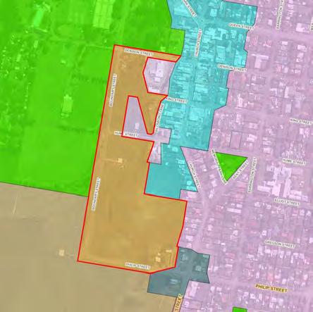
A review of Markwell was undertaken. At Markwell there are ten lots ranging in size from 4000m2 to 9.8ha within the identified Village zone. Council records indicate that the Village zone has been in place since the first planning scheme without any significant development or subdivision occurring in this location compared to the village of Bulahdelah, approximately 10 minutes south of Markwell.
MidCoast Rural Strategy – The Way Forward Page | 56
Aerial Image
Proposed Zone
New Village zone
New Village zone
Lots in the Village zone to the south and east of Markwell Road, are also identified as potentially flood affected which would limit any additional subdivision or development within these areas. Given these limitations the zone change is warranted.
The changes will progress in the draft MidCoast Local Environmental Plan However, it is noted that the opportunity to make a subdivision application using the Village zone and minimum lot size provisions will remain in place until the new MidCoast Local Environmental Plan is in force.
Support for the Village zone at Bundook and Mount George was noted.
The Way Forward
The Village zone changes proposed are to be implemented in the draft MidCoast Local Environmental Plan.
Appendix A includes the objectives and land use table for the Village zone which was provided in the Housing Strategy. The uses have been amended to include the new agritourism reforms proposed by the NSW Government.


MidCoast Rural Strategy – The Way Forward Page | 57
Mount George Bundook
Figure 26: Proposed Village zone at Mount George and Bundook

LARGE LOT RESIDENTIAL 11
Existing situation
Large lot residential areas are commonly known as ‘rural residential estates’, being larger lots with a semi-rural outlook, typically located on the outskirts of towns. The lot sizes vary - if connected to a reticulated sewer system the minimum lot size is 4,000m2 or 1.5ha if no connection.
There are over thirty large lot residential estates across the MidCoast, located at:
• Coastal: Cape Hawke, Charlotte Bay, Coomba Park, Diamond Beach, Hallidays Point, Harrington, Mitchell's Island, Old Bar (west), Smiths Lake, Tea Gardens, Tuncurry (north)
• Rural: Barrington, Brimbin, Bundook, Cundletown (near Taree Airport), Darawank, Dyers Crossing, Failford, Gloucester (north and south), Johns River, Kolodong, Markwell, Minimbah (north), Nabiac, Stroud, Taree surrounds, Pampoolah, Rainbow Flat, Cedar Party, Taree South, Tinonee, Wingham.
The MidCoast Housing Strategy examined our urban areas, providing objectives and land use tables for all residential zones, including the Large Lot Residential zone. The Rural Strategy examined if there were any locations in the rural landscape that had similar characteristics and should be included in this zone.
Draft Rural Strategy
Based on the land use and development standards established in the Housing Strategy, potential large lot residential areas were reviewed in terms of the size and suitability of the lots, the rural values of the land and their current use. Based on this assessment a number of locations were recommended for inclusion in the Large Lot Residential zone around Allworth, Cundletown, Hannam Vale, Johns River, Lansdowne, Nabiac, Stroud, Taree, Tuncurry and Wootton as shown in Figure 28 A minimum lot size of 4,000m2 was applied where reticulated sewerage system is available or 1.5ha where not available.
During consultation sixteen submissions requested that the Large Lot Residential zone be extended over areas at Hallidays Point, Old Bar, Barrington, Coomba Park, Tinonee, Pindimar, Pampoolah, Darawank, Glenthorne, Nabiac, Wingham and Gloucester
Large lot residential analysis
Extension of the Large Lot Residential zone over these areas was reviewed. None of these sites currently display the lot size or character of a large lot residential area. In most cases, the request was to enable further subdivision of the land, which fell outside the scope of the Rural Strategy.
The Way Forward
It is proposed to progress the inclusion in the Large Lot Residential zone of sites around Allworth, Cundletown, Hannam Vale, Johns River, Lansdowne, Nabiac, Stroud, Taree, Tuncurry and Wootton in the draft MidCoast Local Environmental Plan.
Appendix A includes the objectives and land use table for the Large Lot Residential zone which was provided in the Housing Strategy.
MidCoast Rural Strategy – The Way Forward Page | 59

MidCoast Rural Strategy – The Way Forward Page | 60
Figure 27: Proposed land to be included in the Large Lot Residential zone

DWELLING ENTITLEMENTS 12
Existing situation
Not all properties in rural or conservation zones have the entitlement to build a house on the property. The size of the lot is key to determining if a house approval can be sought or more research is needed.
In the rural and conservation zones the minimum lot size can vary from 10ha up to 100ha. If the lot area is the same or larger than the minimum lot size, there is a dwelling entitlement. If the lot area is less, the landowner may need to apply for a dwelling entitlement search.
The search is undertaken under Clause 4.2A Erection of dwelling houses on land in certain rural and conservation protection zones of the Local Environmental Plans and examines:
• any subdivision approvals and the date of the approval. For example, some rural land may have been subdivided under historic Local Environmental Plan provisions. It is important to determine that the subdivision was lawfully approved enabling the dwelling entitlement
• the history of the land holding. The three existing Local Environmental Plans specify different dates for when dwelling entitlements first appeared. The existing holdings that applied on the dates outlined below need to be considered in the search – only one dwelling entitlement could be applied to each existing holding, no matter how many lots existed in the holding. The dates are:
15 May 1964 for the Great Lakes Local Environmental Plan 2014
2 June 1967 for the Greater Taree Local Environmental Plan 2010
17 October 1969 for the Gloucester Local Environmental Plan 2010.
If there is no dwelling entitlement, there are limited options available to obtain development approval for a house. Consolidating neighbouring lots to create a larger lot that meets the minimum lot size in the Local Environmental Plan can provide a dwelling entitlement Development applications for dwellings on under-sized rural lots may be lodged as a request to vary the minimum lot size requirement, using the provisions of Clause 4.6 of the applicable Local Environmental Plan. This clause enables the landowner to apply for a house on an undersized lot by seeking a variation to the minimum lot size. The application must demonstrate why the minimum lot size provisions are either unreasonable or unnecessary in the circumstances. There is no guarantee that the application for a variation will be supported, and that any variation of the lot size by more than 10% will need to be assessed and concurrence provided by the NSW Government.
Draft Rural Strategy
Applying the three dates across the MidCoast was considered problematic, given that the former Council areas no longer exist. The draft Rural Strategy proposed removing the dates, which meant that properties that relied on existing holdings to justify their dwelling entitlements would no longer have a dwelling entitlement when the MidCoast Local Environmental Plan came into force. It is important to note that landowners have had opportunity since the 1960s to establish dwelling entitlements on these properties and build a house.
Dwelling entitlement analysis
Between 2018 and 2021, there was a significant number of applications to undertake a dwelling entitlement search, indicating that there is still a need to provide this service to landowners. It is also important to clearly communicate to the community about the proposed changes to dwelling entitlements. Some Councils have provided a sunset provision that outlines a timeframe for when the existing provisions would lapse (e.g. Clarence Valley, Snowy Monaro and Cessnock).
MidCoast Rural Strategy – The Way Forward Page | 62
It is proposed to include a two-year sunset provision into proposed Clause 4.2A in the new draft MidCoast Local Environmental Plan. This will enable information to be communicated to the community, providing the opportunity to enquire about dwelling entitlements prior to the proposed changes coming into force.
The Way Forward
As part of the new draft MidCoast Local Environmental Plan, Council will include a two-year sunset provision whereby the dwelling entitlement on vacant existing holdings and rural and conservation lots below the minimum lot size that have not been created by a lawfully approved Council subdivision would lapse.
MidCoast Rural Strategy – The Way Forward Page | 63

VISITOR ACCOMMODATION 13
Existing situation
The MidCoast is widely recognised as a popular tourist destination. Tourism is an important industry and can provide an additional source of income for landowners in rural and conservation areas. There are a range of tourist and visitor accommodation opportunities permitted across the rural landscape in the MidCoast in the three existing Local Environmental Plans, being:
• camping grounds and primitive camping
• farm-stay accommodation
• bed and breakfast
• ecotourist facility
• caravan parks, which can include manufactured home estates.
Draft Rural Strategy
The draft Rural Strategy aimed to allow flexibility in rural and conservation zones to enable some forms of visitor accommodation, often related to either a farm or natural setting experience. Except for caravan parks, these uses were proposed to be permitted with consent in most of the rural and conservation zones to provide accommodation for visitors The exception was the Environmental Conservation zone which only permitted eco-tourist facilities.
When assessing future development applications, the suitability of the proposed facility in the landscape will be considered. The draft Rural Strategy also required emergency management plans for these types of visitor accommodation or rural events to carefully consider the safety and wellbeing of visitors. A specific recommendation was the requirement for visitor accommodation in the rural landscape to have for a permanent 24-hour on-site manager
Due to caravan parks potentially transforming into higher density manufactured homes estates, the Rural Strategy proposed that caravan parks would no longer be allowed in rural and conservation zones
Eight submissions were received regarding visitor accommodation. The key areas of concern were:
• the requirement for a permanent on-site manager - considered onerous and unreasonable
• that visitor accommodation was only permitted where there was a dwelling entitlement
• not addressing short-term holiday accommodation (e.g. whole house rentals)
• not permitting ‘caravan parks’ in rural zones
• the type of visitor accommodation being encouraged in the rural and conservation zones.
Visitor accommodation analysis
Each of these issues were reviewed and reported to Council on 27 July 2022. The following provides a summary of the findings and outcomes:
• the requirement for a 24-hour on-site manager in association with visitor accommodation will be removed. However, an on-site manager may still be required for events and facilities where a significant number of visitors or guests will be in attendance. This would be informed through the development assessment process
• the need to have a dwelling entitlement for visitor accommodation will remain. This requirement is typically applied by Councils across regional NSW
• the requirements for short-term rental accommodation will not change. The state-wide regulatory framework will still apply when providing accommodation in rural areas
MidCoast Rural Strategy – The Way Forward Page | 65
• caravan parks will not be permitted in the rural and conservation zones. Camping grounds provide the scale of development appropriate for people travelling through our rural areas. Caravan parks are permitted with consent in the Village zone where an appropriate level of services and facilities can be provided
• the type and scale of visitor accommodation proposed in the rural and conservation zones is appropriate. The Village zone allows accommodation which can cater for more people, given there is typically better access to services and facilities.
Recent NSW Government changes to introduce and encourage agritourism in rural and conservation zones will enable additional flexibility for farm related activities and accommodation for visitors. The current three Local Environmental Plans will reflect these changes for agritourism.
The Way Forward
Given the issues raised in the submissions regarding the requirement for a 24-hour on-site manager for all visitor accommodation, this requirement has been removed. An on-site manager may still be required for events and facilities where a significant number of visitors or guest will be in attendance. This would be informed through the development assessment process when considering risks.
Appendix A includes the objectives and land use tables for the rural and conservation zones which shows the range of visitor accommodation permitted in each zone.
The draft MidCoast Local Environmental Plan will encourage a range of visitor accommodation and activities across the rural landscape, to add to the experiences offered to visitors to the MidCoast.
MidCoast Rural Strategy – The Way Forward Page | 66
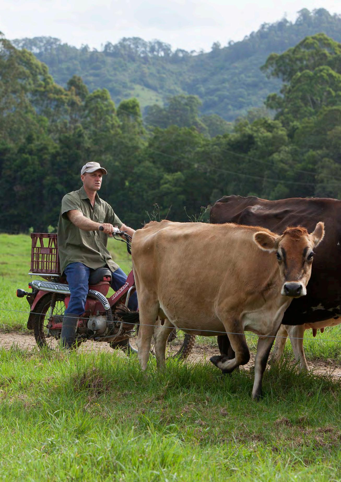
14
NEXT STEPS
Consultation on the Rural Strategy provided significant feedback from landowners, the community and the NSW Government. The ‘MidCoast Rural Strategy – The Way Forward’ document has considered the feedback, resulting in some significant changes in the approach, particularly to the future rural zones and aquifer catchments. Additional information has also been provided to explain the approach on key issues like paper subdivisions and conservation zones.
The ‘MidCoast Rural Strategy – The Way Forward’s key purpose is to establish the planning framework for rural, conservation and waterway zoned land which can be implemented in the new draft MidCoast Local Environmental Plan Information on the proposed suite of zones, the objectives and land use tables and planning controls like minimum lot size, assist to understand the future planning intent for the rural and natural landscapes.
The next steps involve:
• consultation with the relevant NSW Government Departments
• preparation of the new draft MidCoast Local Environmental Plan and Development Control Plan, which will be road-tested prior to Council endorsement
• extensive consultation with the community to discuss the new planning controls in the new draft MidCoast Local Environmental Plan and Development Control Plan.
From developing the ‘MidCoast Rural Strategy’ to writing the new draft MidCoast Local Environmental Plan and Development Control plans; we have appreciated the community’s input to improve how we plan for the MidCoast.
MidCoast Rural Strategy – The Way Forward Page | 68

APPENDIX A DRAFT OBJECTIVES AND LAND USE TABLES
The objectives and land use tables are in a draft form and will be subject to further refinement through the drafting of the new MidCoast Local Environmental Plan
Zone RU1 Primary Production
1. Objectives
To encourage sustainable primary industry production by maintaining and enhancing the natural resource base.
To encourage diversity in primary industry enterprises and systems appropriate for the area.
To minimise the fragmentation and alienation of resource lands.
To minimise conflict between land uses within this zone and land uses within adjoining zones.
To provide for small-scale and complementary rural tourism in association with the primary industry capability of the land.
2. Permitted without Consent
3. Permitted with Consent
Agricultural produce industries; Agriculture; Agritourism; Airstrips; Animal boarding or training establishments; Aquaculture; Artisan food and drink industry; Backpackers’ accommodation; Bed and breakfast accommodation; Boat launching ramps; Boat shed; Camping grounds; Car park; Cellar door premises; Cemeteries; Community facilities; Depots; Dual occupancies; Dwelling houses; Eco-tourist facilities; Educational establishments; Electricity generating works; Emergency services facilities; Environmental facilities; Extractive industries; Farm buildings; Farm experience premises; Farm gate premises; Farm stay accommodation; Flood mitigation works; Forestry; Function centres; Helipads; Home-based child care; Home industries; Information and education facility; Intensive livestock agriculture, Intensive plant agriculture; Jetties; Kiosks; Landscaping material supplies; Markets, Moorings; Open cut mining; Plant nurseries; Public administration buildings; Recreation areas; Recreation facilities (major); Recreation facilities (outdoor); Registered clubs; Respite day care centres; Research station; Roads; Roadside stalls; Rural industries; Rural supplies; Rural workers’ dwellings; School-based child care; Secondary dwellings; Sewerage systems; Signage; Telecommunications facility; Timber yards; Truck depots; Vehicle body repair workshop; Vehicle repair station; Veterinary hospitals; Waste or resource management facility; Waste or resource transfer stations; Water recreation structures; Water supply systems; Wharf or boating facilities; Any development not specified in item 2 or 4
4. Prohibited
Airports; Air transport facility; Amusement centre; Brothel; Caravan parks; Centre-based child care facility; Charter of tourism boating facility; Commercial premises; Correctional centres; Crematorium; Early education and care facility; Entertainment facility; Exhibition home; Exhibition village; Forestry; Freight transport facility; Funeral homes; Hazardous storage establishments; Heavy industrial storage establishment; Health services facility; Heliports; Highway service centre; Home occupation (sex services); Hotel or motel accommodation; Industrial retail outlet; Industrial training facility; Industry; Livestock processing industry; local distribution premises; Marinas; Mooring pens; Mortuary; Offensive storage establishments; Neighbourhood shops; Passenger transport facility; Place of public worship; Port facilities; Recreation facilities (indoor); Residential accommodation; Restaurants or cafes; Restricted premises; Storage premises; Service station; Sex services premises; Shop; Tourist and visitor accommodation; Transport depots; Warehouse or distribution centre; Wholesale supplies.

MidCoast Rural Strategy – The Way Forward Page | 70
Environmental protection works; Extensive agriculture; Home businesses; Home occupations
Zone RU2 Rural Landscape
1. Objectives
To encourage sustainable primary industry production by maintaining and enhancing the natural resource base.
To maintain the rural landscape character of the land.
To provide for a range of compatible land uses, including extensive agriculture.
To provide for rural tourism in association with the primary industry capability of the land which is based on the rural attributes of the land.
To secure a future for agriculture in the area by minimising the fragmentation of rural land and loss of potential agricultural productivity
2. Permitted without Consent
Environmental protection works; Extensive agriculture; Home businesses; Home occupations
3. Permitted with Consent
Agricultural produce industries; Agriculture; Agritourism; Airports; Air transport facility; Airstrips; Animal boarding or training establishments; Aquaculture; Artisan food and drink industry; Backpackers’ accommodation; Bed and breakfast accommodation; Boat launching ramps; Boat shed; Camping grounds; Car park; Cellar door premises; Cemeteries; Centre based child care facilities; Charter and tourism boating facilities; Community facilities; Crematorium; Depots; Dual occupancies; Dwelling houses; Eco-tourist facilities; Educational establishments; Electricity generating works; Emergency services facilities; Environmental facilities; Extractive industries; Farm buildings; Farm experience premises; Farm gate premises; Farm stay accommodation; Flood mitigation works; Forestry; Function centres; Helipads; Home-based child care; Home industries; Hotel or motel accommodation; Information and education facility; Jetties; Kiosks; Landscaping material supplies; Markets, Moorings; Open cut mining; Plant nurseries; Public administration buildings; Recreation areas; Recreation facilities (major); Recreation facilities (outdoor); Registered clubs; Respite day care centres; Research station; Roads; Roadside stalls; Rural industries; Rural supplies; Rural workers’ dwellings; School-based child care; Secondary dwellings; Sewerage systems; Signage; Telecommunications facility; Timber yards; Truck depots; Vehicle body repair workshop; Vehicle repair station; Veterinary hospitals; Waste or resource management facility; Waste or resource transfer stations; Water recreation structures; Water supply systems; Wharf or boating facilities; Any development not specified in item 2 or 4
4. Prohibited
Amusement centre; Brothel; Caravan parks; Centre-based child care facility; Charter of tourism boating facility; Commercial premises; Correctional centres; Early education and care facility; Entertainment facility; Exhibition home; Exhibition village; Freight transport facility; Funeral homes; Hazardous storage establishments; Heavy industrial storage establishment; Health services facility; Heliports; Highway service centre; Home occupation (sex services); Industrial retail outlet; Industrial training facility; Industry; Livestock processing industries; Marinas; Mooring pens; Mortuary; Neighbourhood shops; Offensive storage establishments; Passenger transport facility; Place of public worship; Port facilities; Recreation facilities (indoor); Residential accommodation; Restaurants or cafes; Restricted premises; Storage premises; Service station; Sex services premises; Tourist and visitor accommodation; Transport depots; Warehouse or distribution centre; Wholesale supplies.

MidCoast Rural Strategy – The Way Forward Page | 71
Zone RU3 Forestry 1.
MidCoast Rural Strategy – The Way Forward Page | 72
Objectives To enable development for forestry purposes. To enable other development that is compatible with forestry land uses. 2. Permitted without Consent Uses authorised under the Forestry Act 2012 or under Part 5B (Private native forestry) of the Local Land Services Act 2013 3. Permitted with Consent Aquaculture; Roads; Rural industries; Water recreation structures; Water supply systems 4. Prohibited Any development not specified in item 2 or 3
Zone RU4 Small Lot Primary Production
1. Objectives
To enable sustainable primary industry and other compatible land uses.
To encourage and promote diversity and employment opportunities in relation to primary industry enterprises, particularly those that require smaller lots or that are more intensive in nature.
To minimise conflict between land uses within this zone and land uses within adjoining zones.
To provide for rural tourism in association with the primary industry production capability of the land which is based on the rural attributes of the land.
To secure a future for agriculture in the area by minimising the fragmentation of rural land and loss of potential agricultural productivity
2. Permitted without Consent
Environmental protection works; Extensive agriculture; Home businesses; Home occupations
3. Permitted with Consent
Agricultural produce industries; Agriculture; Agritourism; Airports; Air transport facility; Airstrips; Animal boarding or training establishments; Aquaculture; Artisan food and drink industry; Backpackers’ accommodation; Bed and breakfast accommodation; Boat launching ramps; Boat shed; Camping grounds; Car park; Cellar door premises; Cemeteries; Centre based child care facilities; Charter and tourism boating facilities; Community facilities; Crematorium; Depots; Dual occupancies; Dwelling houses; Eco-tourist facilities; Educational establishments; Electricity generating works; Emergency services facilities; Environmental facilities; Extractive industries; Farm buildings; Farm experience premises; Farm gate premises; Farm stay accommodation; Flood mitigation works; Forestry; Function centres; Helipads; Home-based child care; Home industries; Home occupation; Hotel or motel accommodation; Information and education facility; Intensive livestock agriculture, Intensive plant agriculture; Jetties; Kiosks; Landscaping material supplies; Markets, Moorings; Open cut mining; Plant nurseries; Public administration buildings; Recreation areas; Recreation facilities (major); Recreation facilities (outdoor); Registered clubs; Respite day care centres; Research station; Roads; Roadside stalls; Rural industries; Rural supplies; Rural workers’ dwellings; School-based child care; Secondary dwellings; Sewerage systems; Signage; Telecommunications facility; Timber yards; Truck depots; Vehicle body repair workshop; Vehicle repair station; Veterinary hospitals; Waste or resource management facility; Waste or resource transfer stations; Water recreation structures; Water supply systems; Wharf or boating facilities; Any development not specified in item 2 or 4
4. Prohibited
Amusement centre; Brothel; Caravan parks; Centre-based child care facility; Charter of tourism boating facility; Commercial premises; Correctional centres; Early education and care facility; Entertainment facility; Exhibition home; Exhibition village; Freight transport facility; Funeral homes; Hazardous storage establishments; Heavy industrial storage establishment; Health services facility; Heliports; Highway service centre; Home occupation (sex services); Industrial retail outlet; Industrial training facility; Industry; Livestock processing industries; Marinas; Mooring pens; Mortuary; Neighbourhood shops; Offensive storage establishments; Passenger transport facility; Place of public worship; Port facilities; Recreation facilities (indoor); Residential accommodation; Restaurants or cafes; Restricted premises; Storage premises; Service station; Sex services premises; Tourist and visitor accommodation; Transport depots; Warehouse or distribution centre; Wholesale supplies.
MidCoast Rural Strategy – The Way Forward Page | 73
Zone RU5 Village
1. Objectives
To provide for a range of land uses, services and facilities that are associated with a rural village.
To enable range of land uses, including non-residential development, that does not prejudice the established land use pattern within the village.
To maintain and enhance the historical significance, character and scenic quality of village settings.
2. Permitted without Consent
Environmental protection works; Home Occupations; Extensive agriculture
3. Permitted with Consent
Agritourism; Amusement centres; Animal boarding or training establishments; Boat building and repair facilities; Boat launching ramps; Boat sheds; Building identification sign; Camping grounds; Car parks; Caravan parks; Cellar door premises; Cemetery; Centre-based child care facilities; Charter and tourism boating facilities; Child care centres; Commercial premises; Community facilities; Depots; Dwelling houses; Eco-tourist facilities; Educational establishments; Emergency services facilities; Entertainment facilities; Environmental facilities; Exhibition homes; Farm buildings; Farm experience premises; Farm gate premises; Farm stay accommodation; Flood mitigation works; Function centres; Health services facility; Helipad; Highway service centres; Homebased child care; Home businesses; Home industries; Horticulture; Industrial retail outlets; Industrial training facilities; Industries; Information and education facilities; Jetties; Marinas; Mooring pens; Moorings; Mortuaries; Neighbourhood shops; Oyster aquaculture; Passenger transport facilities; Places of public worship; Public administration building; Recreation areas; Recreation facilities (indoor); Recreation facilities (outdoor); Recreation facilities (major); Registered clubs; Research stations; Residential accommodation; Respite day care centres; Restricted premises; Roads; Roadside stalls; Rural industries; Schools; Service stations; Sewerage systems; Signage; Storage premises; Tank-based aquaculture; Transport depots; Truck depots; Tourist and visitor accommodation; Vehicle body repair workshops; Vehicle repair stations; Veterinary hospitals; Warehouse and distribution centres; Waste or resource management facilities; Water recreation structures; Water supply systems; Wharf or boating facilities; Wholesale supplies.
4. Prohibited
Bulky good premises; Pond-based aquaculture; Waste or resource transfer; stations; Any development not specified in item 2 or 3
MidCoast Rural Strategy – The Way Forward Page | 74
Zone C2 Environmental Conservation
1. Objectives
To protect, manage and restore areas of high ecological, scientific, cultural or aesthetic values.
To prevent development that could destroy, damage or otherwise have an adverse effect on those values
2. Permitted without Consent
Environmental protection works;
3. Permitted with Consent
Bee keeping; Dwelling houses; Eco-tourist facilities; Emergency services facilities; Environmental facilities; Flood mitigation works; Oyster aquaculture; Recreation facilities (outdoor); Research station; Roads; Sewerage systems; Water supply systems
4. Prohibited
Business premises; Hotel or motel accommodation; Industries; Local distribution premises; Multi dwelling housing; Pond-based aquaculture; Recreation facilities (major); Residential flat buildings; Restricted premises; Retail premises; Seniors housing; Service stations; Tank-based aquaculture; Warehouse or distribution centres; Any other development not specified in item 2 or 3
MidCoast Rural Strategy – The Way Forward Page | 76
1. Objectives
To protect, manage and restore areas with special ecological, scientific, cultural or aesthetic values.
To provide for a limited range of development that does not have an adverse effect on those values.
To conserve biological diversity and native vegetation corridors, and their scenic qualities.
2. Permitted without Consent
Environmental protection works; Home businesses; Home occupations
3. Permitted with Consent
Agritourism; Bed and breakfast
signs; Camping Grounds; Cellar door premises; Dual occupancies; Dwelling houses; Eco-tourist facilities; Emergency service facilities; Environmental facilities; Extensive agriculture; Farm Buildings; Farm experience premises; Farm gate premises; Farm stay accommodation; Home-based childcare; Home Industry; Horticulture; Information and education facilities; Jetties; Oyster aquaculture; Pond-based aquaculture; Recreation facilities (outdoor); Research station; Roads; Roadside Stalls; Sewerage systems; Tank-based aquaculture; Water supply systems; Wharf or boating facilities
4. Prohibited
MidCoast Rural Strategy – The Way Forward Page | 77
accommodation; Building identification signs; Business identification
Industries; Local distribution premises; Multi dwelling housing; Residential flat buildings; Retail premises; Seniors housing; Service stations; Warehouse or distribution centres; Any other development not specified in item 2 or 3
Zone C4 – Environmental Living
1. Objectives
To provide for low-impact residential development in areas with special ecological, scientific or aesthetic values
To ensure that residential development does not have an adverse effect on those values.
To provide for other types of low-impact development that does not have an adverse effect on the special ecological, scientific or aesthetic values of the land
2. Permitted without Consent
Environmental protection works; Home businesses; Home occupations
3. Permitted with Consent
Agritourism; Animal boarding or training establishments; Backpackers’ accommodation; Bed and breakfast accommodation; Boat launching ramps; Boat sheds; Building identification signs; Business identification signs; Camping grounds; Cellar door premises; Centre-based childcare facilities; Community facilities; Dual occupancies; Dwelling houses; Eco-tourist facilities; Emergency services facilities; Environmental facilities; Extensive agriculture; Farm buildings; Farm experience premises; Farm gate premises; Farm stay accommodation; Flood mitigation works; Function centres; Home-based child care; Home industries; Horticulture; Information and education facilities; Jetties; Oyster aquaculture; Pond-based aquaculture; Recreation facilities (outdoor); Research stations; Respite day care centres; Roads; Roadside stalls; Sewerage systems; Tank-based aquaculture; Water supply systems; Wharf or boating facilities
4. Prohibited
Industries; Local distribution premises; Service stations; Warehouse or distribution centres; Any other development not specified in item 2 or 3
MidCoast Rural Strategy – The Way Forward Page | 78
Zone W1 Natural Waterways
1. Objectives
To protect the ecological and scenic values of natural waterways.
To prevent development that would have an adverse effect on the natural values of waterways in this zone.
To provide for sustainable fishing industries and recreational fishing
2. Permitted without
Consent
Environmental facilities; Environmental protection works;
3. Permitted with
Consent
Aquaculture; Boat launching ramps; boat sheds; Charter and tourism boating facilities; Community facilities; Emergency services facilities; Extractive industries; Flood mitigation works; Jetties; Moorings; Recreation areas; Recreation facilities (outdoor); Research stations; Vehicle sales or hire premises; Water recreation structures; Water supply systems; Wharf or boating facilities
4. Prohibited
Business premises; Hotel or motel accommodation; Industries; Local distribution premises; Marinas; Multi dwelling housing; Recreation facilities (major); Residential flat buildings; Restricted premises; Retail premises; Seniors housing; Service stations; Warehouse or distribution centres; Any other development not specified in item 2 or 3
MidCoast Rural Strategy – The Way Forward Page | 79
Zone W2 Recreational Waterways
1. Objectives
To protect the ecological, scenic and recreation values of recreational waterways.
To allow for water-based recreation and related uses.
To provide for sustainable fishing industries and recreational fishing.
2. Permitted without Consent
Environmental facilities; Environmental protection works;
3. Permitted with Consent
Aquaculture; Boat launching ramps; Boat sheds; Building identification signs; Business identification signs; Business premises; Charter and tourism boating facilities; Community facilities; Emergency services facilities; Entertainment facilities; Extractive industries; Flood mitigation works; Food and drink premises; Function centres; Helipads; Heliports; Information and education facilities; Jetties; Kiosks; Marinas; Markets; Mooring pens; Moorings; Passenger transport facilities; Recreation areas; Recreation facilities (outdoor); Research stations; Restaurants or cafes; Roads; Vehicle sales or hire premises; Water recreation structures; Water supply systems; Wharf or boating facilities;
4.
Prohibited
Industries; Local distribution premises; Multi dwelling housing; Residential flat buildings; Seniors housing; Warehouse or distribution centres; Any other development not specified in item 2 or 3
MidCoast Rural Strategy – The Way Forward Page | 80
Zone W3 Working Waterways
1. Objectives
To enable the efficient movement and operation of commercial shipping, water-based transport and maritime industries.
To promote the equitable use of waterways, including appropriate recreational uses
To minimise impacts on ecological values arising from the active use of waterways.
To provide for sustainable fishing industries.
2. Permitted without Consent
Environmental facilities; Environmental protection works;
3. Permitted with Consent
Aquaculture; Boat building and repair facilities; Boat launching ramps; Boat sheds; Building identification signs; Business identification signs; Business premises; Charter and tourism boating facilities; Community facilities; Emergency services facilities; Entertainment facilities; Extractive industries; Flood mitigation works; Food and drink premises; Freight transport facilities; Function centres; Helipads; Heliports; Information and education facilities; Jetties; Kiosks, Marinas; Markets; Mooring pens; Moorings; Passenger transport facilities; Port facilities; Recreation areas; Recreation facilities (outdoor);Restaurants or cafes; Roads; Signage; Vehicle sales or hire premises; Water recreation structures; Water supply systems; Wharf or boating facilities;
4. Prohibited
Industries; Multi dwelling housing; Residential flat buildings; Seniors housing; Warehouse or distribution centres; Any other development not specified in item 2 or 3
MidCoast Rural Strategy – The Way Forward Page | 81
Zone IN4 Working Waterfront
1. Objectives
To retain and encourage industrial and maritime activities on foreshores.
To identify sites for maritime purposes and for activities requiring direct foreshore access.
To ensure that development does not have an adverse impact on the environment and visual qualities of the foreshore.
To encourage employment opportunities.
To minimise any adverse effect of development on land uses in other zones.
To encourage complementary activities to revitalise waterfront areas.
2. Permitted without Consent
Home occupations
3. Permitted with Consent
Aquaculture; Boat building and repair facilities; Boat launching ramps; Boat sheds; Building identification signs; Business identification signs; Car parks; Charter and tourism boating facilities; Environmental facilities; Environmental Protection works; Farm buildings; Flood mitigation works; Food and drink premises; Freight transport facilities; General industries; Helipads; Home businesses; Home-based child care; Industrial retail outlets; Industrial training facilities; Information and education facilities; Jetties; Kiosks; Light industries; Local distribution premises; Marinas; Mooring pens; Moorings; Neighbourhood shops; Passenger transport facilities; Recreation areas; Research stations; Restaurants or cafes; Roads; Sewerage systems; Signage; Specialised retail premises; Vehicle sales or hire premises; Waste or resource management facilities; Water recreation structures; Warehouse or distribution centres; Water supply systems; Wharf or boating facilities; Wholesale supplies
4. Prohibited
Any other development not specified in item 2 or 3
Note: objectives and land use tables adopted in the NSW Department of Planning and Environment’s Employment Zone Reform.
MidCoast Rural Strategy – The Way Forward Page | 82
MidCoast Council: Rural Strategy Overview, July 2021, DRAFT 17 Yalawanyi Ganya 2 Biripi Way PO Box 482 Taree 2430 Mon-Fri 8.30am - 4.30pm Tel: (02) 7955 7777
