
19 minute read
NOMINATED URBAN RELEASE AREAS – OVERVIEW LIST
The following nominated release areas can have an application lodged (Planning Proposal) to rezone the land in the following time periods.
Short-Term (1-5 Years) 2022 - 2027
Regional City;
Taree Urban Release Area 1 (Edinburgh Street)
Taree South Urban Release Area 1 (Glenthorne Rd)
Cundletown Urban Release Area 1 (Taree Regional Airport)
Cundletown Urban Release Area 2 (Lansdowne Road)
Strategic Centres;
Forster Urban Release Area 1 (Lakes Way)
Forster Urban Release Area 2 (Southern Parkway)
Forster Urban Release Area 3 (Burrawan St)
Forster Urban Release Area 4 (Fairview West)
Gloucester Growth Area 1 (Lavers Street)
Coastal Towns;
Diamond Beach Urban Release Area 1 (Tourist Precinct)
Diamond Beach Urban Release Area 2 (Diamond Beach Road/Old Soldiers Road)
Diamond Beach Urban Release Area 3 (Old Soldiers Road Realignment)
Red Head Urban Release Area 1 (14 Red Head Road)
Red Head Urban Release Area 2 (180 Diamond Beach Road)
Red Head Urban Release Area 4 (16 Meers Drive)
Black Head Urban Release Area 1 (438 Blackhead Road and 21 Greenview Drive)
Tallwoods Urban Release Area 1 (Redefining the village centre)
Old Bar/Wallabi Point Urban Release Area 2 (Lot 50 Shantull Drive)
Tea Gardens Urban Release Area 1 (Myall River Downs)
Tea Gardens Urban Release Area 3 (Parry’s Cover Marina)
Medium-Term (6-10 Years) 2028 – 2032
Strategic Centres;
Forster Urban Release Area 5 (Cape Hawke Drive)
Forster Urban Release Area 6 (Bert’s Farm)
Coastal Towns;
Red Head Urban Release Area 3 (Lot 3 Hope Street)
Harrington Urban Release Area 1 (812 & 822 Harrington Road)
Inland Towns;
Tinonee Urban Release Area 1 (Edge Road)
Tinonee Urban Release Area 2 (southern side of The Bucketts Way)
Wingham Urban Release Area 1 (Lot 11 Wingham Road)
Long-Term (10+ Years) 2032 +
Regional City;
Taree Urban Release Area 2 (Kanangra Drive)
Taree Urban Release Area 3 (former Peter’s Dairy Factory)
Taree South Urban Release Area 2 (The Bucketts Way)
Strategic Centres;
Gloucester Urban Release Area 2 (Cemetery Road)
Coastal Towns;
Tallwoods Urban Release Area 2 (205 Blackhead Road)
Old Bar/ Wallabi Point Urban Release Area 1 (Red Gum Road)
Hawks Nest Urban Release Area 1 (known as North Hawks Nest)
Tea Gardens Urban Release Area 2 (Myall Way)
Inland Towns;
Wingham Urban Release Area 2 (Murray Road and Skyline Drive)
Villages;
Bulahdelah Urban Release Area 1 (Lee Street)
Coopernook Urban Release Area 1 (Lot 7 Bungalow Road)
Nabiac Urban Release Area 4 (Pacific Highway – North)
Nominated Urban Release Areas
Short-Term (1-5 Years) 2022 - 2027
Regional City;
Taree Urban Release Area 1 (Edinburgh Street)
Constraints: Flooding Watercourses and wetland/riparian vegetation Adjacent to agricultural land risking sterilisation (a stock flood refuge area will need to be designated as part of a rezoning and the ability for the location of dwellings associated with such land) Constraint level – LOW
Opportunity: Additional low-density residential land supply in an area subject to high demand (last expansion area in Taree West) Extensive views to the south across the Manning River

Identified Settlement Expansion
Zone
Indicative rezoning boundaries
Taree South Urban Release Area 1 (Glenthorne Road/Erikson Lane)
Constraints: Vegetation Flooding, stormwater and water quality Constraint level – LOW
Opportunity: Additional employment land


Identified Settlement Expansion
Zone
Indicative rezoning boundaries
Cundletown Urban Release Area 1 (Taree Regional Airport)
Constraints: Scattered trees Airport limitations (obstacle limitation, crash zone, light control) Constraint level – LOW
Opportunity: Additional employment opportunities associated with the airport expansion Access and leverage from the Cundletown bypass


Identified Settlement Expansion
Zone
Indicative rezoning boundaries
Cundletown Urban Release Area 2 (Taree Regional Airport [Lansdowne Road])
Constraints: Scattered trees Bushfire Possible contamination Airport limitations (obstacle limitation, crash zone, light control) Constraint level – LOW
Opportunity: Additional employment and/or residential opportunities associated with and leveraging from the airport expansion


Identified Settlement Expansion
Zone
Indicative rezoning boundaries
Forster Urban Release Area 1 (Lakes Way)
Constraints: Vegetation - squirrel glider habitat Bushfire Flooding, stormwater and water quality adjacent to sensitive wetlands Access to The Lakes Way Constraint level – MEDIUM
Opportunities: A range of employment and residential outcomes opposite Stocklands Walk/cycleway improvements Securing an east-west squirrel glider habitat corridor


Identified Settlement Expansion
Zone
Indicative rezoning boundaries
Forster Urban Release Area 2 (Southern Parkway)
Constraints: Vegetation - squirrel glider habitat Bushfire Flooding, stormwater and water quality Western side of road only likely to be able to be used for drainage and habitat retention/Improvement (except the area between the two retirement villages which has development potential), whereas eastern side of road has development potential Constraint level – east – LOW, west – MEDIUM/HIGH
Opportunities: Additional residential land supply Walk/cycleway improvements Improving the east-west squirrel glider habitat corridor


Identified Settlement Expansion
Zone
Indicative rezoning boundaries
Forster Urban Release Area 3 (Burrawan St)
Constraints: Vegetation corridor Bushfire Stormwater and water quality Flooding and watercourses Fragmented ownership Constraint level – MEDIUM
Opportunity: Additional residential land supply Walk/cycleway improvements Securing a corridor between adjacent areas of vegetation

Identified Settlement Expansion

Zone
Indicative rezoning boundaries
Forster Urban Release Area 4 (Fairview West)
Constraints: Vegetation – threatened species Bushfire Stormwater and water quality Access to The Lakes Way Constraint level – MEDIUM
Opportunity: Minor additional residential land supply Improved drainage Threatened species protection


Identified Settlement Expansion
Zone
Indicative rezoning boundaries
Gloucester Urban Release Area 1 (Lavers Street)
Constraints: Scattered trees Railway corridor noise buffer Constraint level – LOW
Opportunity: Additional residential land supply Securing environmental corridor linkages

Identified Settlement Expansion
Zone
Indicative rezoning boundaries

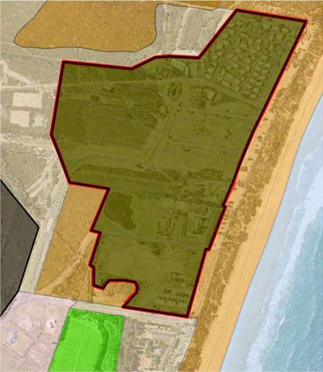
Diamond Beach Urban Release Area 1 (Tourist Precinct)
Constraints: Minimal – already has urban zoning Existing development undertaken in isolation and not integrated Constraint level – LOW
Opportunity: Additional medium density residential land supply Removal of SP3 – Tourist zone that is proving not viable in this location due to investment difficulties
Note: This area is proposed to be rezoned to the R3 Medium Density Residential Zone as adopted in the MidCoast Housing Strategy for inclusion in the new MidCoast Local Environmental Plan.

Zone
Indicative rezoning boundaries
Identified Settlement Expansion
Diamond Beach Urban Release Area 2 (Diamond Beach Road/Old Soldiers Road)
Constraints: Vegetation Bushfire Stormwater and water quality Riparian buffers High groundwater table Constraint level – MEDIUM
Opportunity: Additional low-density residential land supply in an area subject to high demand Securing important environmental habitat and corridors


Identified Settlement Expansion
Zone
Indicative rezoning boundaries
Diamond Beach Urban Release Area 3 (Old Soldiers Road Realignment)
Constraints: Vegetation and corridors Koala habitat Bushfire Constraint level – MEDIUM
Opportunity: Provision of a viable alternative access to Hallidays Point Improved bushfire egress for Hallidays Point community Additional large lot residential land supply Removing road from within the Nature Reserve

Identified Settlement Expansion
Zone
Indicative rezoning boundaries

Red Head Urban Release Area 1 (14 Red Head Road)
Constraints: Vegetation and corridors Koala habitat Littoral rain forest buffer Stormwater and water quality Constraint level – MEDIUM
Opportunity: Securing environmental corridors (east-west and north-south) Additional low-density residential land supply in an area subject to high demand Continuation of open space network from the Seascape development (within the
Littoral rainforest buffer)


Identified Settlement Expansion
Zone
Indicative rezoning boundaries
Red Head Urban Release Area 2 (180 Diamond Beach Road)
Constraints: Vegetation and corridors Constraint level – LOW
Opportunity: Minor additional low-density residential land supply in an area subject to high demand Securing environmental corridors


Identified Settlement Expansion
Zone
Indicative rezoning boundaries
Red Head Urban Release Area 4 (16 Meers Drive)
Constraints: Vegetation Stormwater and water quality Constraint level – MEDIUM
Opportunity: Additional low-density residential land supply in an area subject to high demand

Zone
Indicative rezoning boundaries
Identified Settlement Expansion

Black Head Urban Release Area 1 (438 Blackhead Road and 21 Greenview Drive)
Constraints: Vegetation Infrastructure - needs a roundabout at Diamond Beach Road/Blackhead Road for access (construction expected in 2022 as part of residential development) Constraint level – MEDIUM
Opportunity: Additional low-density residential land supply in an area subject to high demand Potential industrial area for Hallidays Point near previous concrete batching plant

Identified Settlement Expansion
Zone
Indicative rezoning boundaries

Tallwoods Urban Release Area 1 (Redefining The Village Centre)
Constraints: Stormwater and water quality Vegetation Bushfire Minimal overall – already has urban zoning Constraint level – LOW
Opportunity: The planning consultant acting on behalf of the golf course owner has provided
Council with a new masterplan outlining changes to their land that would provide a commercial centre for the village and some additional housing opportunities to support this on land that is not needed for golf course operations. To realise the community’s vision for sports fields and associated facilities at
Tallwoods.


Identified Settlement Expansion
Zone
Indicative rezoning boundaries
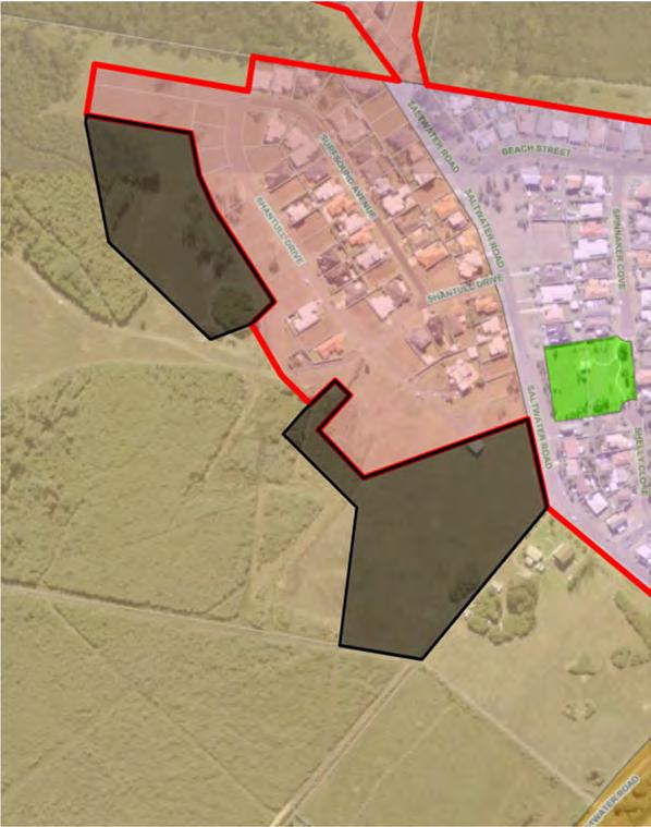
Old Bar/Wallabi Point Urban Release Area 2 (Lot 50 Shantull Drive)
Constraints: Vegetation Nearby National Park Bushfire Stormwater/water quality Low-lying land Constraint level – MEDIUM
Opportunity: Additional low-density residential land supply to finalise expansion of Wallabi Point Improved drainage from existing development

Identified Settlement Expansion
Zone
Indicative rezoning boundaries
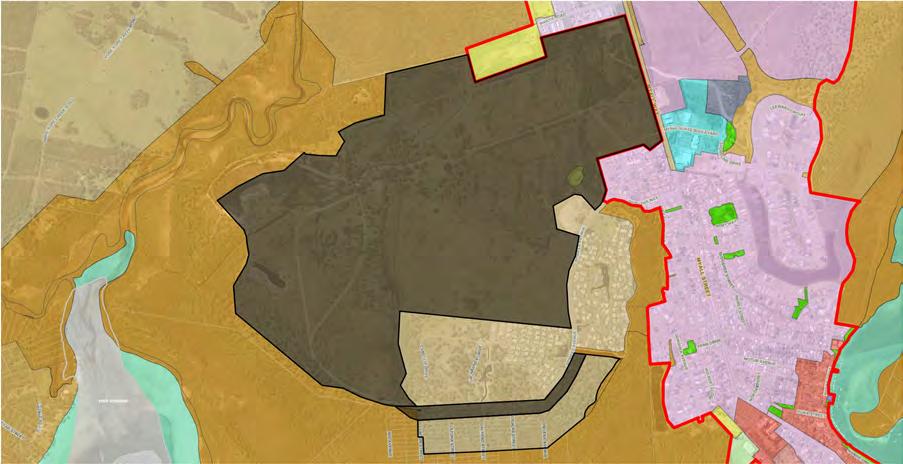
Tea Gardens Urban Release Area 1 (Myall River Downs)
Constraints: Vegetation scattered throughout, with some significant dense concentrations and corridors Bushfire Drainage Adjoining industrial estate Flooding and sea level rise Stormwater and water quality Constraint level – MEDIUM
Opportunity: Significant additional low-density residential land supply The majority of vacant residential land in Tea Gardens is owned by one company and introducing another player into the market will encourage competition and provide choice Ensures retention of important vegetation and corridors Provides opportunity for location of sporting fields for the community (there are no fields at present and a 4ha site is needed) Remove a paper subdivision in exchange for narrow strip of residential development
Identified Settlement Expansion
Zone
Indicative rezoning boundaries

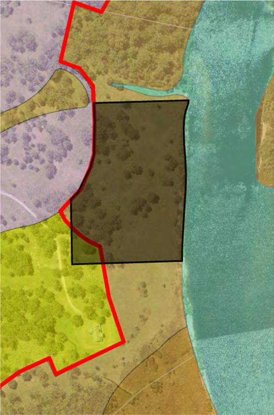
Tea Gardens Urban Release Area 3 (Parry’s Cove Marina)
Constraints: Hydrodynamics Terrestrial and aquatic biodiversity Navigation dredging, intervals and financial burden Stormwater/water quality Isolation/separation from Tea Gardens Constraint level – MEDIUM
Opportunity: Additional boating/recreation infrastructure and facilities in an area with high boat usage

Identified Settlement Expansion
Zone
Indicative rezoning boundaries
Villages; N/A
Medium-Term (6-10 Years) 2028 – 2032
Regional City; N/A
Strategic Centres;
Forster Urban Release Area 5 (Cape Hawke Drive)
Constraints: Vegetation Bushfire Stormwater and water quality Groundwater table Water courses Constraint level – MEDIUM
Opportunity: Significant additional residential land supply Completion of The Southern Parkway Walk/cycleway improvements
Zone
Identified Settlement Expansion

Indicative rezoning boundaries

Forster Urban Release Area 6 (Bert’s Farm)
Constraints: Flooding (approximately 95% of site) Vegetation and threatened species, particularly Wallum Froglet & Squirrel Glider Bushfire Coastal wetland and buffer area Coastal environmental area Stormwater and water quality Isolated/separated from Forster Access to The Lakes Way Constraint level – HIGH
Opportunity: Securing an environmental corridor in an environmentally sensitive area

Zone
Indicative rezoning boundaries
Identified Settlement Expansion

Coastal Towns;
Red Head Urban Release Area 3 (Lot 3 Hope Street)
Constraints: Vegetation Stormwater and water quality Steep and visually prominent land Constraint level – MEDIUM
Opportunity: Additional low-density residential land supply in an area subject to high demand

Zone
Indicative rezoning boundaries
Identified Settlement Expansion

Harrington Urban Release Area 1 (812 & 822 Harrington Road)
Constraints: Flooding Bushfire Scattered trees Fill required (may not be viable at present) Constraint level – MEDIUM
Opportunity: Rectify a zoning anomaly as this land is surrounded by urban zones and land that has been previously filled for development Minor additional low-density residential land supply in an area subject to high demand


Identified Settlement Expansion
Zone
Indicative rezoning boundary
Inland Towns;
Tinonee Urban Release Area 1 (Ridge Road)
Constraints: Vegetation, Koala habitat and corridors Constraint level – MEDIUM
Opportunity: Provide additional low-density residential land supply where suitable in the medium term Capitalise on logical urban edge of settlement and provide some additional rural residential development in alignment with adjoining zone


Identified Settlement Expansion
Zone
Indicative Zone Boundary

Tinonee Urban Release Area 2 (The Bucketts Way)
Constraints: Vegetation, Koala habitat, corridors Constraint level – MEDIUM
Opportunity: Provide additional rural residential (R5) development

Identified Settlement Expansion
Zone
Indicative Zone Boundary

Wingham Urban Release Area 1 (Lot 11 Wingham Road)
Constraints: Flooding Bushfire Physical separation from Wingham township Constraint level – LOW
Opportunity: Additional low-density residential land Walk/cycleway to town centre
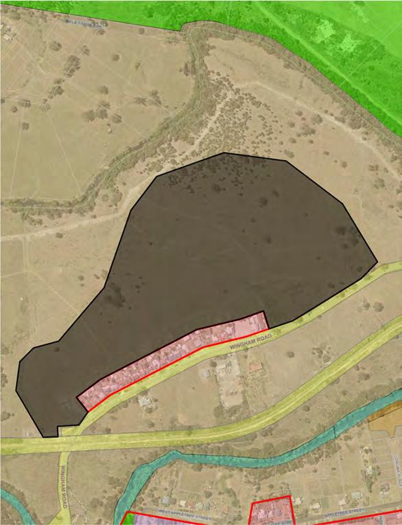

Identified Settlement Expansion
Zone
Indicative rezoning boundaries
Long-Term (10+ Years) 2032 +
Regional City;
Taree Urban Release Area 2 (Kanangra Drive)
Constraints: Scattered trees Bushfire Koala habitat Constraint level – LOW
Opportunity: Additional low-density residential land when required (not needed in the short-medium term) Adjacent to a school and sporting fields


Identified Settlement Expansion
Zone
Indicative rezoning boundaries
Taree Urban Release Area 3 (Former Peter’s Dairy Factory)
Constraints: Potential contamination including asbestos Traffic impact on Railway Parade/Oxley Street (former Pacific Highway) intersection Adjacent industrial uses Constraint level – LOW
Opportunity: Mixed use development making use of heritage buildings for apartments, business development and supporting businesses Ability to utilise disused rail corridor to provide pedestrian/cycle link back to the
FIGTREES on the Manning development and the Taree Recreation
Grounds/Entertainment/Recreation precinct and the Taree CBD


Zone
Indicative rezoning boundaries
Identified Redevelopment Opportunity
Taree South Urban Release Area 2 (The Bucketts Way)
Constraints: Vegetation Bushfire Flooding, stormwater and water quality Constraint level – MEDIUM
Opportunity: Additional employment land when required Building upon existing industrial uses of service station and landscaping supply business


Zone
Indicative rezoning boundaries
Identified Settlement Expansion
Gloucester Urban Release Area 2 (Cemetery Road)
Constraints: Scattered trees Stormwater and water quality Amount of existing vacant industrial land (additional land not needed in short-medium term) Constraint level – LOW
Opportunity: Additional industrial land supply


Identified Settlement Expansion
Zone
Indicative rezoning boundaries
Tallwoods Urban Release Area 2 (205 Blackhead Road)
Constraints: Vegetation (particularly on Crown road reserve) Bushfire Stormwater/water quality Constraint level – MEDIUM
Opportunity: Additional low-density residential land supply when required (current zoned land sufficient for short-medium term)


Identified Settlement Expansion
Zone
Indicative rezoning boundaries
Old Bar/Wallabi Point Urban Release Area 1 (Red Gum Road)
Constraints: Vegetation scattered throughout, with some dense concentrations Sydney Peppermint tree at its northern limit making its conservation important Infrastructure – requires an additional sewer pump station to service residential development Bushfire Constraint level – MEDIUM
Opportunity: Additional low-density residential land supply when required (current zoned land sufficient for short-medium term) to finalise expansion of Old Bar Ensures retention of important vegetation


Identified Settlement Expansion
Zone
Indicative rezoning boundaries
Hawks Nest Urban Release Area 1 (known as North Hawks Nest)
Constraints: Vegetation and threatened species Environmental Corridor Bushfire Koala habitat Coastal environment area Isolated/separated from Hawks Nest Significant portion of land required to be dedicated to NPWS on the western side of
Mungo Brush Road to enable development to be considered on eastern side of road (in accordance with 2001 Commissioners Report - otherwise zone all land E2) Constraint level – MEDIUM
Opportunity: Securing habitat and environmental corridors in exchange for low density residential development


Identified Settlement Expansion
Zone
Indicative rezoning boundaries
Tea Gardens Urban Release Area 2 (Myall Way)
Constraints: A significant stand of vegetation and corridors Stormwater/water quality Isolation/separation from Tea Gardens Constraint level – MEDIUM
Opportunity: Additional low-density residential land supply when required (not required in shortmedium term)


Zone
Indicative rezoning boundaries
Identified Settlement Expansion
Wingham Urban Release Area 2 (Murray Road and Skyline Drive)
Constraints: Servicing – water reservoir in the middle of site and adequate water pressure requires 25m of head-pressure which may not be possible without significant additional public investment Constraint level – MEDIUM
Opportunity: Additional low-density residential land supply when required (most likely in long term)


Identified Settlement Expansion
Zone
Indicative rezoning boundaries
Bulahdelah Urban Release Area 1 (Lee Street)
Constraints: Proximity to Pacific Highway Vegetation and corridors Bushfire Buffer to National Park Constraint level – MEDIUM
Opportunity: Additional village expansion when required (most likely in the very long term)


Identified Settlement Expansion
Zone
Indicative rezoning boundaries
Coopernook Urban Release Area 1 (Lot 7 Bungalow Road)
Constraints: Dispersed vegetation Constraint level – LOW
Opportunity: Additional village expansion when required (current zoned land sufficient for shortmedium term)


Identified Settlement Expansion
Zones
Indicative rezoning boundaries
Nabiac Urban Release Area 1 (Pacific Highway – North)
Constraints: Proximity of Pacific Highway Constraint level – MEDIUM
Opportunity: To recognise existing industrial and business developments occupying the land (ice factory and motorcycle museum) Provide some minor industrial opportunities


Identified Settlement Expansion
Zone
Indicative rezoning boundaries
Stroud Urban Release Area 1 (Boundary Street)
Constraints: Flooding Bushfire Riparian vegetation and setbacks Constraint level – LOW
Opportunity: Additional village expansion when required (most likely in the very long term)


Identified Settlement Expansion


