1 minute read
Lake Moomaw Trails


MORRIS HILL BIKE TRAIL
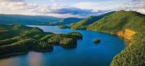
This 1.0 mile trail that runs along the west side of the campground is suitable for casual strolls and easy mountain biking. There is nearly no elevation change. The trail continues straight ahead following a grassy cut through the forest to a brief access drive for a service building. At this access, you may turn right and head back to the camping area or turn left to the overflow camping area paved road. Turn left to the Visitor Center and a walkway down to an overlook of the dam with seating. The views of fjord-like Lake Moomaw and the massive earth-fill dam are impressive. A good idea of the depth of the lake can be seen from looking downstream at the clear, rock-strewn Jackson River.
www.fs.usda.gov/recarea/gwj/recreation/hiking/ recarea/?recid=78546&actid=50
DIRECTIONS:
From I-64, take exit 16A or 16B to Highway 220. Go north on Highway 220 for 5.6 miles and turn left onto State Route 687. Go 3.2 miles and turn left onto State Route 641/666. Travel north for 4.2 miles until you reach a three-way intersection. Turn right onto State Route 605 and follow it to the Morris Hill Campground.
OLIVER MOUNTAIN TRAIL
From Fortney Branch boat launch, this 3.3 mile trail winds along the side of Fortney Branch drainage before ascending up a ridge and crossing FDR 192. Continuing past FDR 192, breathtaking views can be found of Lake Moomaw and Gathright Dam.
www.fs.usda.gov/recarea/gwj/recreation/hiking/ recarea/?recid=78576&actid=50
DIRECTIONS:
From I-64, take exit 16A or 16B to Route 220. Travel north on Highway 220 for 5.6 miles and turn left onto SR 687. Go 3.2 miles and turn left onto SR 641/666 north for 4.2 miles. At the three-way intersection, turn right onto SR 605 and go straight to the stop sign. Turn right into Fortney Boat Launch area.


