


The Town of Olive retained Milone & MacBroom, Inc. (MMI) to assist with a Land Use Planning Feasibility Study for the hamlet of Boiceville (Figure 1-1). The overall goal of the study was to assist the Town of Olive, the Boiceville Community Planning Committee, and Boiceville business owners and residents to make decisions that will lead to reduced flooding and a more floodresilient community. Much of the hamlet was developed prior to the enactment of zoning and prior to the adoption of Flood Insurance Rate Maps.
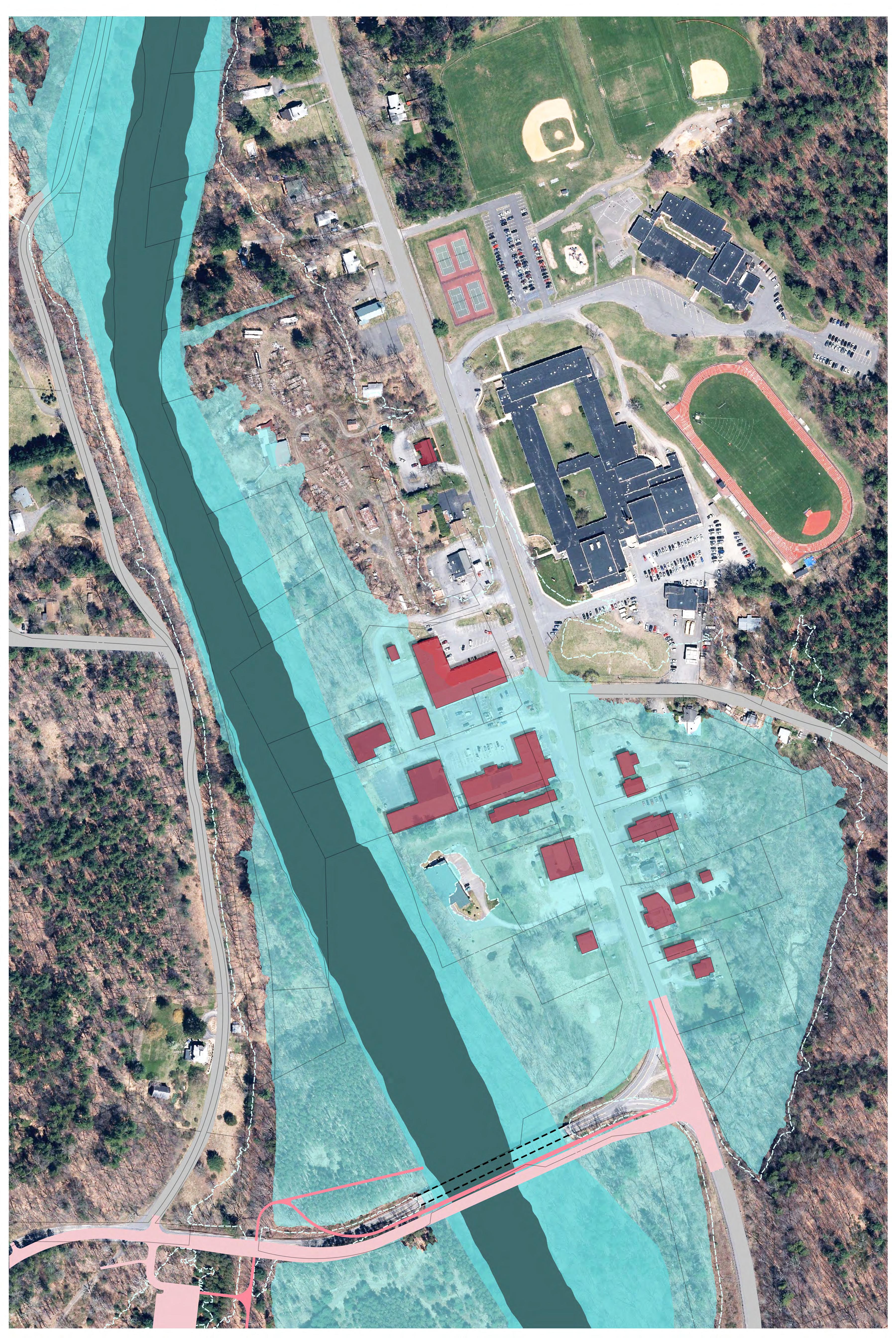
The hamlet has experienced severe flooding and flood-related damages most recently during Tropical Storm Irene in August 2011. The town recently completed a Local Flood Analysis (LFA), which identified 17 buildings in Boiceville that are located within the 100-year flood zone or Special Flood Hazard Area (SFHA). The SFHA includes properties that are within the 100-year flood zone, which have a 1 percent or greater chance of flooding during any given year. Most financial institutions require that a property with a mortgage that is located within the 100-year flood zone obtain flood insurance through the National Flood Insurance Program. Based on aerial mapping, there are a total of 26 parcels within the hamlet that are located within the SFHA. Most of these buildings form the commercial center of Boiceville, including an IGA supermarket, post office, pharmacy, medical office, and several other nearby businesses on either side of Route 28. All of these businesses are located within the 100-year flood zone and have been subject to damages during recent flood events. The one exception is the wastewater treatment plant, which was built on an elevated hilltop that is outside of the 100-year flood zone
The LFA identified several flood mitigation strategies that required further study This study is intended to further evaluate and identify the most feasible flood mitigation options for residents, businesses, and property owners in the 100-year flood zone
To explore these alternatives, the following steps were taken:
• Reviewed prior studies and plans including local, state, and federal studies and local and federal ordinances and regulations
• Conducted site reconnaissance including a questionnaire to understand property owners' willingness to relocate and identify potential relocation sites
• Organized a Community Workshop that includes a visioning session and a design session, which will be constructed to gain community input and identify objectives
• Developed Master Plan concepts that depict the full or partial relocation of the Boiceville business district out of the 100-year flood zone
• Developed recommendations to identify action items needed to implement the Reuse and Relocation Plan
A series of options for the future of Boiceville was evaluated including no action, floodproofing, and partial or complete relocation of the commercial uses within the hamlet to a new site. The plans presented are meant to provide guidance to businesses, residents, and property owners as to what options or combination of options is feasible for a reimagined Boiceville


The Master Plan concepts shown in this study are conceptual in nature and rely on a high-level analysis of existing site conditions. Additional due diligence should be conducted in later planning and design phases in order to better understand more detailed site conditions and the financial implications of the reuse and relocation plan.
The area of focus consists of a concentration of commercial, professional, and manufacturing uses within the hamlet of Boiceville to the west of Route 28 and approximately 500 feet north of the Route 28A bridge (See Figure 2-1). There are also a few commercial and residential buildings to the east of Route 28 and within this area. This area, referred to herein as the Commercial Hamlet Area, is bordered by the Esopus Creek to the west and extends across and beyond Route 28 to the east. This area is nearly entirely within the 100-year flood zone of Esopus Creek. As a result, the businesses and residences within this area have been subject to repeated flood damages.
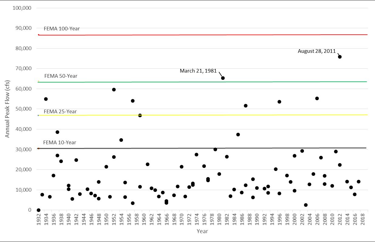
According to data collected at the stream gauge station just upstream of the commercial hamlet area, the Esopus Creek at Coldbrook gauge, there have been a total of 12 flood events that have exceeded the 10-year flood since 1932. Of these 12 floods, nine exceeded the 25-year flood, and two were greater than a 50-year flood event (See Figure 2-2). Boiceville has not experienced a 100-year flood, at least not since 1932.
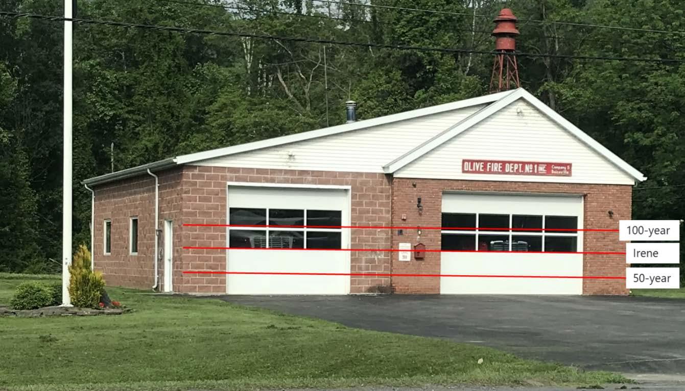
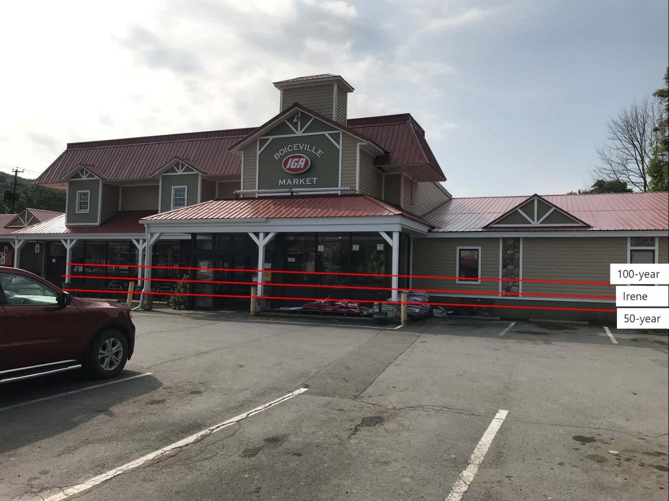
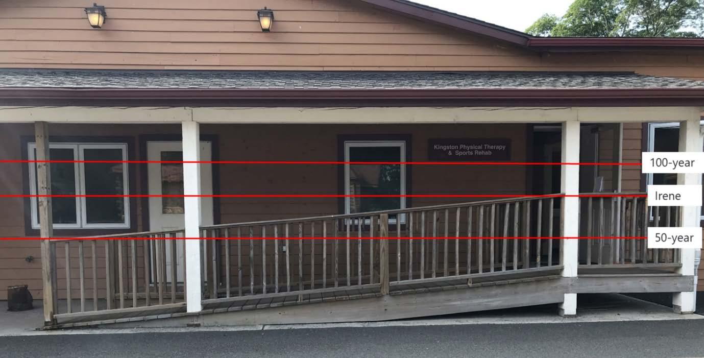
A flood-depth analysis was performed as part of the LFA study (Woidt, 2017). Flood-depth analysis determines the water surface elevation at different locations within the hamlet under different flood scenarios. As an example, at the Olive Fire Department, the flood depth during the 100-year flood event would be over 8.5 feet. At the IGA supermarket, the flood depth during the 100-year flood event would be between 6.5 and 8.5 feet. At the medical office, the flood depth during the 100-year flood event would be over 8.5 feet. Figures 2-3 to 2-5 depict approximate flood heights under different flood scenarios, including the 2011 Tropical Storm Irene flood, at the firehouse, the IGA grocery store, and a medical office building.
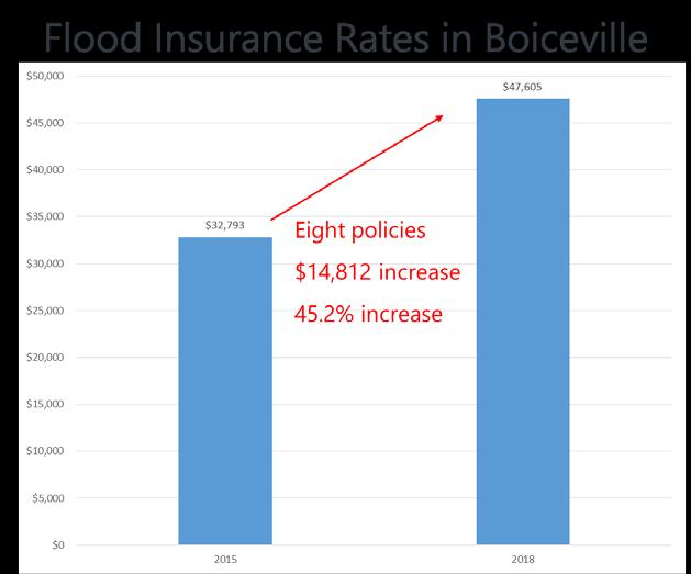
As a community participating in the National Flood Insurance Program (NFIP), properties within the town of Olive are able to purchase flood insurance through the Federal Emergency Management Agency's (FEMA) NFIP. There are currently eight flood insurance policyholders in the hamlet of Boiceville. The cost of flood insurance has increased dramatically on these policies since 2015. In 2015, the cost of the eight policies was $32,793, and this cost has increased 45 percent to $47,605 in 2018 (See Figure 2-6).
Numerous sources provided information for this report including several studies and plans that have been prepared concerning flooding in Boiceville, as well as plans and regulations that govern land use activities and permitted uses within flood-prone areas. The sources that provided information for this report are listed below and discussed in detail in Appendix A:
• Esopus Creek Stream Management Plan
• Ulster County Multi-Jurisdictional Hazard Mitigation Plan
• Ulster County Flood Insurance Study (FIS)
• NYSDEC Waterbody Inventory/Priority Waterbodies List
• New York State Section 303(d) List of Impaired Waters
• NYSDEC Water Quality Standards and Classifications program
• Olive Local Flood Analysis
• Town of Olive Zoning Code
• Town of Olive Flood Damage Prevention Law
The Town of Olive completed an LFA in 2017. The LFA identified flood mitigation scenarios for consideration. The scenarios include doing nothing, protecting flood-prone buildings in place with a levee, moving buildings away from flood-prone areas through buyouts and relocations, and protecting buildings in place through elevations and floodproofing.
In addition, two projects have occurred within Boiceville that could directly affect the future development potential within the hamlet. These projects include the construction of the Ashokan Rail Trail and the installation of the Boiceville sewer district. Both projects are described in more detail below
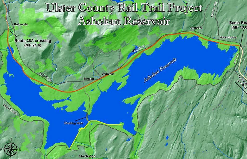
During the data collection process, information regarding the rail trail extending to Boiceville was collected. Known as the Ashokan Rail Trail, this is an Ulster County and New York City Department of Environmental Protection (NYCDEP) project that will extend 11.5 miles between West Hurley and Boiceville (See Figure 3-1). This public recreational trail is intended to be part of the larger rail trail system extending from the Walkway over the Hudson to the Catskills.
In the town of Olive, a parking area will be constructed to the west of Esopus Creek and off Route 28A. The rail trail will have a spur trail that extends beneath Route 28A, along the Route 28A bridge to the Route 28 intersection and turning north along Route 28 to connect with the commercial hamlet area in Boiceville.

Town of Olive Boiceville Sewer District
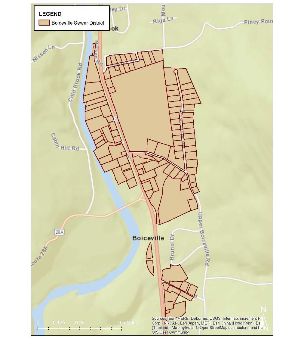
A wastewater treatment plant (WWTP) and stormwater system exist in Boiceville. The system includes a 7,398-square-foot WWTP, a new pumping station, and a sewer system with 3.5 miles of sewer mains to replace on-site septic systems for 126 residential and commercial properties in Boiceville, including two buildings in the Onteora School District. The WWTP can treat up to 75,000 gallons of wastewater per day. The sewer district primarily serves the hamlet of Boiceville on either side of New York State (NYS) Route 28. To the north, the sewer district extends to the north side of Center Road; to the east, the district extends to the east side of Deerfield Road. To the south, the district extends five parcels further south of DeSilva Road and includes most parcels along DeSilva Road. The district does not include the parcels along Brunel Drive. To the west, the district extends to Esopus Creek, where parcels outside of NYCDEP watershed land exist (See Figure 3-2). The WWTP itself is located on a 2.2-acre parcel adjacent to Esopus Creek. The district includes several undeveloped parcels located along and set back from NYS Route 28.
Zoning within the hamlet of Boiceville is broken into five zoning districts. As shown on Figure 3-3, there are two clusters located along Route 28 that are within the Business Highway (B/H). The northern cluster encompasses parcels on either side of Route 28 and extends from the Route 28A intersection to the Piney Point Road intersection. The southern section only contains parcels to the east of Route 28 and extends from just north of DeSilva Road to approximately ¾ mile to the south (or ¼ mile north of Lohrer Road). This district permits single-family residences, all uses permitted in the R/E-1A district, and retail and personal service businesses designed to meet dayto-day and convenience needs. The southern cluster is predominantly within the B/H district, with a linear segment that is further set back from Route 28 falling in the Business/Village (B/V) zoning district. The B/V district permits the same uses as the B/H district with the exception that a special permit is required for retail and personal service businesses designed to meet day-to-day and convenience needs.

The remainder of the hamlet consists of three residential zoning districts –Residential/Conservation (R/C-10A), Residential Rural (R/R-3A), and Residential ExUrban (R/E-1A). The R/C district can be found to the south of Route 28A and adjacent to the Ashokan Reservoir and the Esopus Creek as well as in areas further from Route 28 that are primarily owned by NYC or NYS. The R/R district can be found further from Route 28 and often bordering the R/C district. The R/E district is generally located in closer proximity to Route 28 or Route 28A.
The permitted uses for these three residential districts are as follows:
R/C District:
Single-family dwellings, forestry operations, tourist or boarding houses, nursery schools, kennels, private nonprofit membership clubs, utility infrastructure (with limitations), government use, commercial recreational use, parks and recreation facilities, water supply and sewer disposal systems, electronic transmission structures, and resort hotels
R/R District:
All uses permitted in the R/C district, plus religious facilities, schools, libraries, museums, hospitals, nursing or convalescent homes, and office or light industrial uses with lot size and location requirements
R/E District:
All uses permitted in the R/R district
In addition to establishing zoning districts, the Town of Olive Code, Chapter 155 Zoning, Section 155-25 contains 'Individual standards for certain special permit uses' and contains additional requirements for permitted uses in floodplain areas. The Town Code predominantly addresses flooding concerns in Chapter 97, 'Flood Damage Prevention," discussed below.
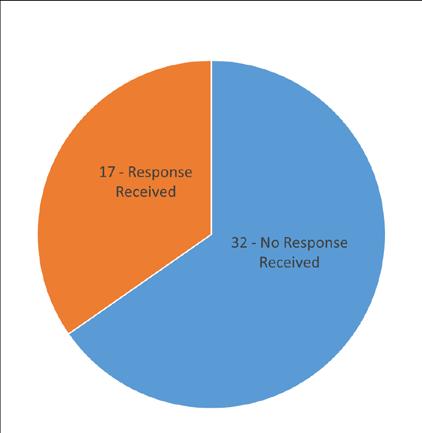
Questionnaires were distributed to properties in or near the 100-year flood zone. The questionnaire asked questions about flood history; willingness to participate in different flood mitigation strategies; the type, nature, and size of their building or business; and any locational characteristics that were important to the business or property owner. In total, 49 questionnaires were distributed to residents and businesses. Responses were received from 17 of those residents or businesses, for a 35 percent response rate.
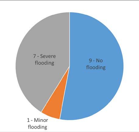
Based on the responses received, nine of the respondents did not experience flooding, one experienced minor flooding, and seven experienced severe flooding All of the respondents who experienced flooding were located within the 100-year flood zone while those who did not experience flooding were located within the 500-year flood zone.
An examination of the desired flood mitigation strategies amongst the questionnaire respondents and letter writers is captured in Table 4-1 below.
TABLE 4-1
Questionnaire Responses: Flood Mitigation Preferences
All respondents that experienced flooding were interested in some type of flood mitigation strategy. Of the 11 respondents that experienced flooding, eight were interested in a buyout process or a combination of strategies while three were interested in only floodproofing measures and not the buyout process.
Of the eight respondents that did not experience flooding, three were not interested in any mitigation measures, four were interested in implementing floodproofing measures but not a buyout program, and one respondent was interested in floodproofing or a buyout program as a mitigation strategy.
Businesses and commercial property owners were then asked a series of follow-up questions on the size, uses, and character of their businesses as well as the locational characteristics that were important to them. This information informed the relocation plan site selection process and ensured that sites aligned with the needs of businesses and property owners. Most businesses chose to locate in Boiceville due to the access and visibility to traffic on Route 28 and proximity to residences, other businesses, and Onteora High School. Many businesses also noted the importance of having access to sewer infrastructure.
Additional letters were submitted to the town that discussed the individuals' flood experiences and desired strategies for flood mitigation in the future. These individuals had experienced severe flooding during Tropical Storm Irene
The project team conducted a survey of Boiceville and the town of Olive in order to identify potential relocation sites within the study area Additional reconnaissance was conducted using Geographic Information Systems (GIS) data including environmental, natural resources, infrastructure, and assessor's data. This analysis helped ensure that the selected relocation sites align with the needs of business and property owners.
According to feedback received from the Property Owner Questionnaires, the ideal site or sites should have the following locational characteristics:
• Located within the hamlet of Boiceville
• Located on Route 28 with good visibility to traffic on Route 28
• Located within the Boiceville Sewer District
A site consisting of eight separate tax parcels just to the north of the current business district was identified as the only site that met the locational characteristics and is assessed for feasibility later in this report.
The project team conducted a full-day Planning and Design Workshop on September 29, 2018, to solicit additional feedback from property owners, businesses, residents, and the general public. During the workshop, participants discussed future options for buildings within the hamlet of Boiceville that are located within the 100-year flood zone
Participants were asked to review the vision statement for the plan and provide any comments and suggestions on how the vision statement could be improved. The vision statement stated that the goal of the proposed project is, "To assist the Town of Olive, the Boiceville Community Planning Committee, and Boiceville business owners and residents to make decisions that will lead to reduced flooding and a more flood-resilient community." One sentiment that was shared was the concern that without a concentration of commercial uses like the current hamlet there is no Boiceville, and the community would have no center or shopping options nearby. Participants expressed the need to maintain a commercial center that is close to Onteora High School, located along Route 28, and close to the existing shopping plaza area. These criteria align with the site selection priorities received during the property-owner questionnaire and align with the site locational characteristics discussed in Section 4.2
Some business owners expressed a desire to remain in their current location and focus their efforts on floodproofing their businesses in place. This is often the most economical option for businesses as the money received through a buyout program will likely not be sufficient to cover the cost of new construction on another site. Knowing that some businesses wish to relocate and others wish to floodproof in place reinforces the need to relocate businesses to another location within Boiceville so that they remain proximate to other business uses.
There was also discussion of the feasibility of other infrastructure improvements such as the installation of a levee or berm The feasibility of those improvements is discussed in greater detail in Section 6.5.
This section is intended to provide guidance to individual property owners and businesses so that they can make informed decisions on how to make their properties more flood resilient. Sections 6.1, 6.2, and 6.3 discuss options for those that are looking to participate in the buyout and/or relocation program Section 6.4 discusses options for those property owners looking to floodproof in place. Figure 6-1a depicts a decision-making flow chart that a business can utilize to make decisions regarding flood resiliency. Figure 6-1b presents a similar decision-making flow chart to assist residential homeowners in making decisions regarding flood resiliency.
Under the New York City-funded flood buyout program (NYCFFBO Program), priority properties may be acquired using New York City (NYC) funds. These priority properties can be identified in a variety of ways including the following:
• An LFA in which an engineer performs a hydraulic analysis
• Catskill Watershed Corporation's Flood Hazard Mitigation Implementation Program
• Individual properties as part of a stream restoration project
• Individual properties experiencing erosion hazard
• Individual properties that have inundation hazards and are not located in designated areas including hamlet or village areas, commercial or industrial areas, or along specific roadways
The buyout process requires concurrence from the local municipality often more than once during the buyout process. The property under consideration must undergo an evaluation process such as an LFA analysis, erosion hazard, or inundation hazard analysis. The community can elect to take title of the real property or can defer ownership to the NYCDEP. As a final step, a conservation easement must be granted to the New York State Department of Environmental Conservation (NYSDEC) for the buyout property. The easement will contain development limitations for all portions of the subject property located within the 100-year floodplain. Examples of the restrictions include minimization of impervious surfaces or making community structures open on all sides to allow floodwaters to flow through the building. The conservation easement development restrictions can be extended to those areas beyond the 100-year floodplain with the agreement of the municipality.
MMI developed two conceptual Master Plans that show relocation options for a site within the hamlet of Boiceville. This potential relocation site is located to the north of the existing commercial district and was selected because it satisfies the site selection criteria as requested by local citizens and businesses during this planning process. The potential relocation site is within the hamlet of Boiceville, thus preserving the community's business district and shopping options for residents. The relocation site is located on Route 28, within the Boiceville Sewer District, and proximate to existing businesses and Onteora High School The relocation site is also zoned as part of the Highway Business (HB) district, and all the same uses are permitted as the existing commercial hamlet area.
Yes No
Is the property an appropriate candidate for relocation?
Relocate the business or the property’s function
Example: Businesses located where flood depths are deepest
Is the building already 2 feet above the BFE?
Yes
Eliminate Basement
Can it be elevated?
Eliminate basement and elevate building
Can it be easily floodproofed?
Elevate building utilities, key assets, and pollution sources
Yes No
Is the resident or owner requesting to sell the property and relocate?
Relocate the resident or homeowner
Is the building already 2 feet above the BFE?
Yes No
Eliminate Basement Can it be elevated?
Yes No
Eliminate basement and elevate building
Consider elevating the building utilities and pollution sources (SD/SI* will trigger elevation)
*Substantial Damage/Substantial Improvement
Note: All improvements must be consistent with the Flood Damage Prevention Code. Consult the Olive Code Enforcement Officer in all cases
As shown in Figure 6-2, the potential relocation site is primarily outside of the 100-year flood zone and consists of eight properties totaling approximately 10 acres. Six properties are vacant or contain vacant buildings although some are currently used to store and process lumber. Two parcels contain active businesses; one is the Community Bank, which will be incorporated into the newly designed shopping plaza area for conceptual purposes, and the other is the Argos Animal Hospital, which was preserved under the conceptual plans.
The two conceptual Master Plans are intended to depict a reimagined commercial district within the hamlet and depict the reuse of properties that are currently within the 100-year flood zone. The Master Plans are not an exact footprint for the future design of the site. The size and design of the Master Plan is ultimately dependent on the number of businesses and property owners who wish to relocate. The Master Plans could be altered in a more detailed design effort to include other uses such as single-family residences, apartments and/or a small hotel. The development may also occur in phases over an extended period of time according to demand and funding availability.
The lands denoted in Figures 3-2 and 3-3, which lie east of the hamlet, recognize commercial areas outside of the immediate hamlet. With extension of the WWTP facility to this location, there is ample area for commercial relocation and/or development in Boiceville.
It should also be noted that any future commercial or retail development could be directed to the hamlet of Shokan within the town of Olive. The hamlet is located to the south and east of Boiceville, and Shokan has space available for development that is located outside of the SFHA. In addition, a study is currently being undertaken to assess the development of a Wastewater Treatment Plant (WWTP) to service Shokan. The construction of a WWTP would support a greater density of commercial development.
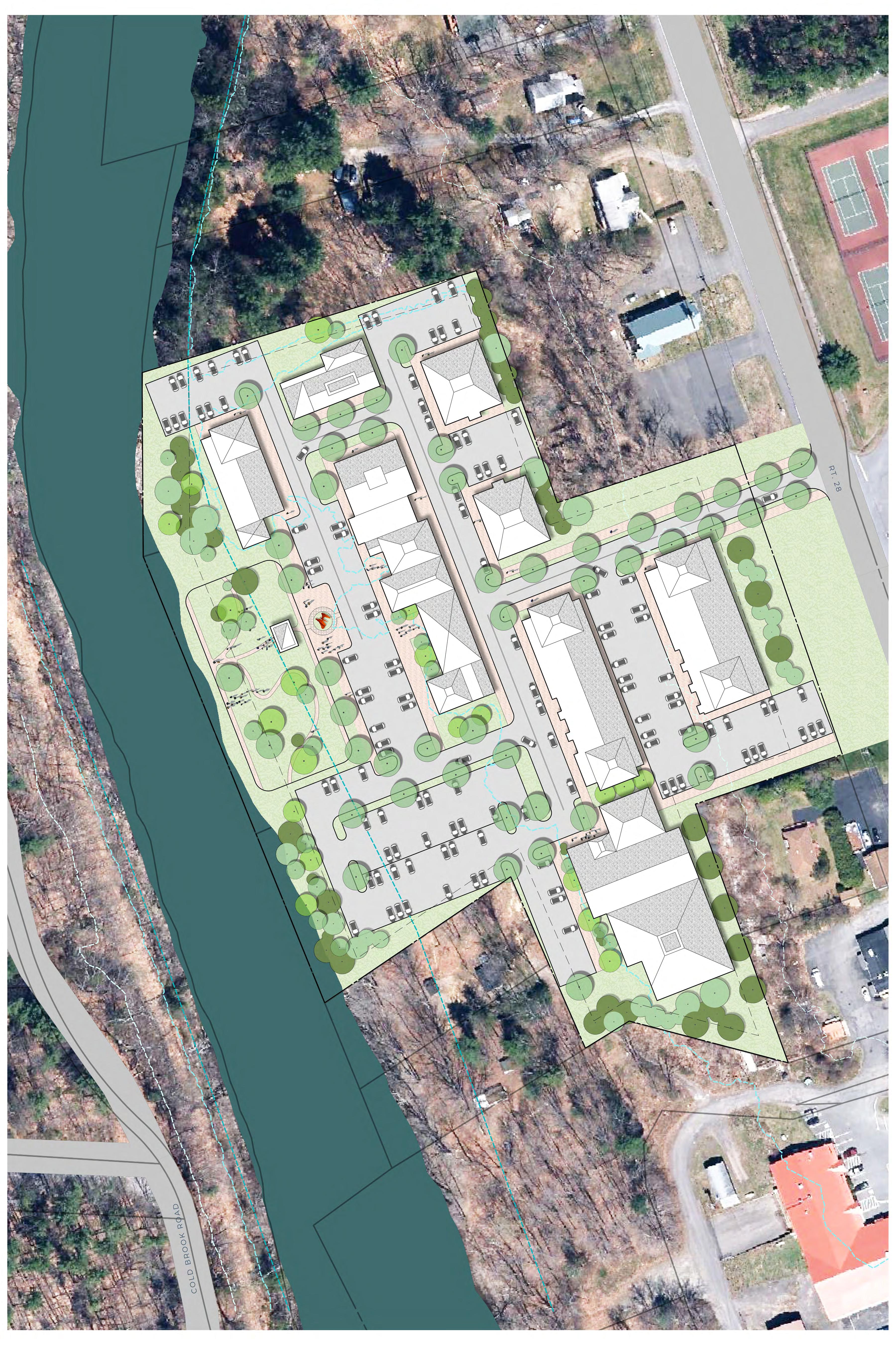
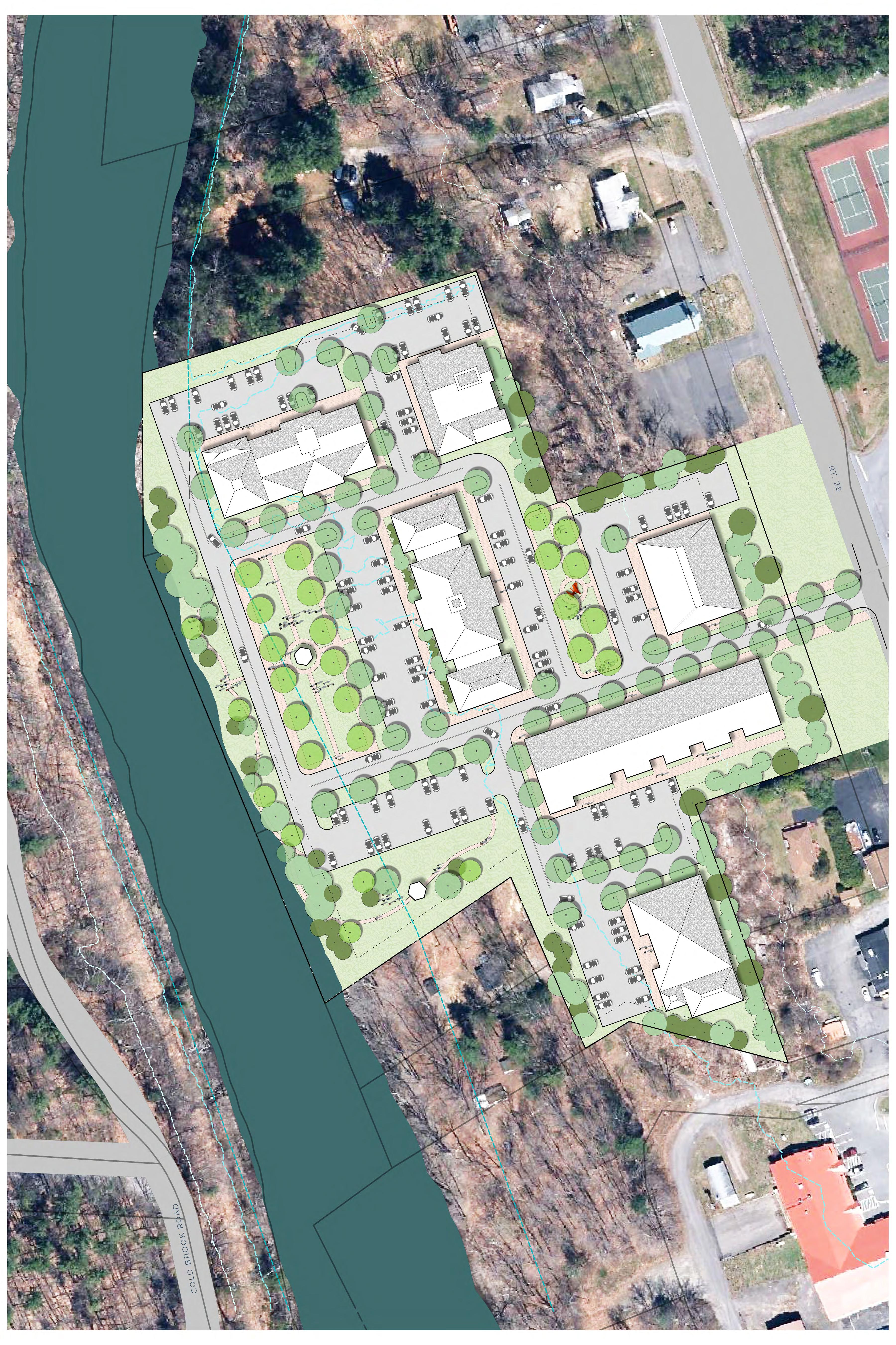
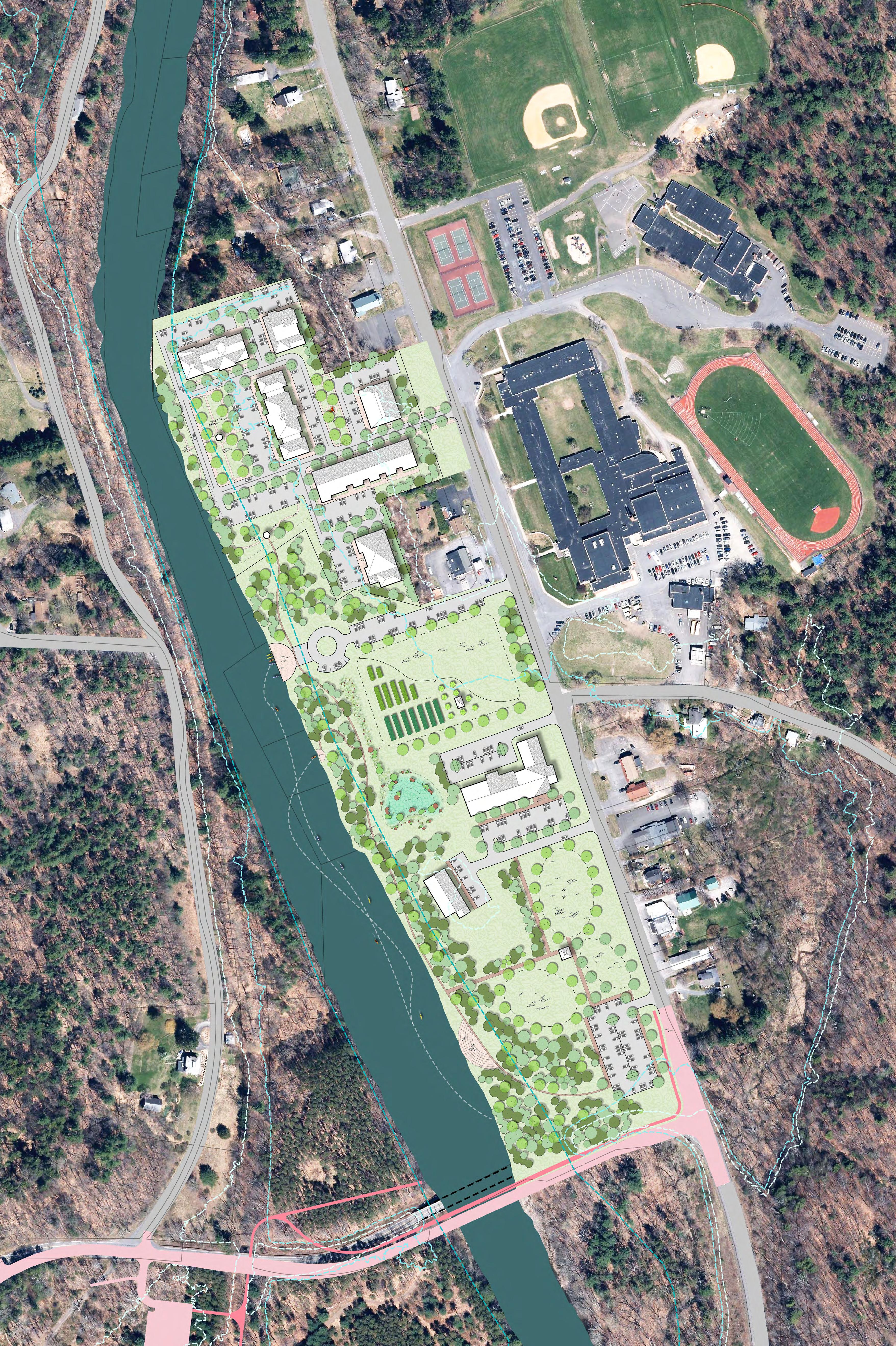
For Master Plan A, it was assumed that all existing businesses currently located within the 100- year floodplain would be relocated to the new site (See Figure 6-3). The design does not account for 100 percent of the existing building square footage, but due to the presence of currently vacant building space, the amount provided is expected to be sufficient. The design plan shows 117,200 square feet (sf) of potential space dispersed between eight buildings. This replaces 118,037 sf of building space from the existing site. This design includes all of the parking spaces and setbacks required by the zoning code. While there are parking spaces located adjacent to the buildings with which they are associated, a large communal parking area is also tucked behind the buildings in the southwestern corner of the site. This layout places all building structures outside of the 100-year floodplain and only greenspace and parking areas within the 100-year floodplain.
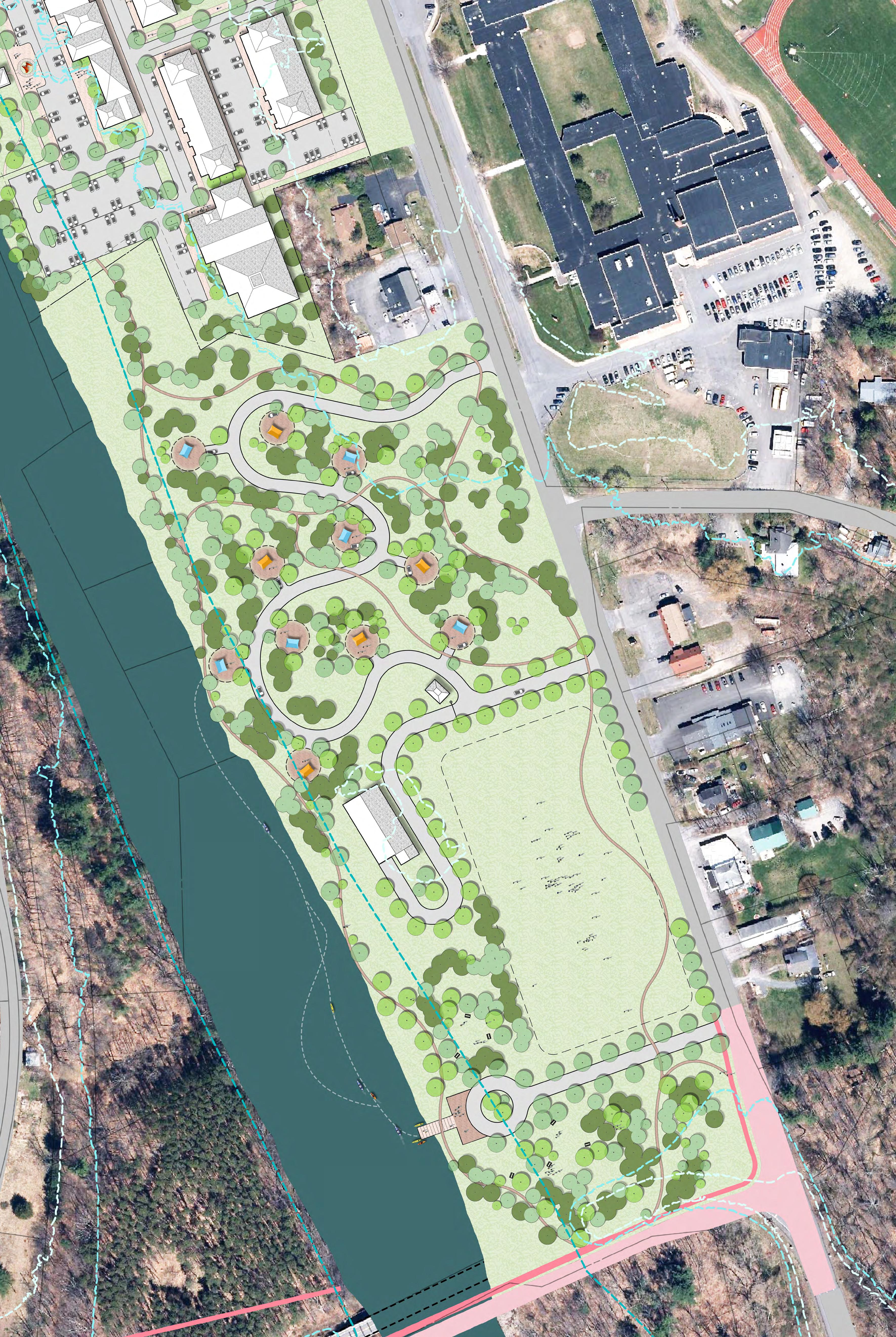
With the relocation of the existing shopping plazas and businesses, the large land area within the 100-year floodplain would become vacant. The newly vacated land area could become a riverfront park with a range of recreational activities and amenities that are appropriate for a flood-prone area such as a picnic area, stream access, large event space, or walkway trails (See Figure 6-4). The stream access, along with the future Ashokan Rail Trail, could help bolster tourism in the hamlet and provide a larger customer base for existing businesses. The development of the relocation site in combination with the proposed riverfront park can be viewed in Figure 6-5.



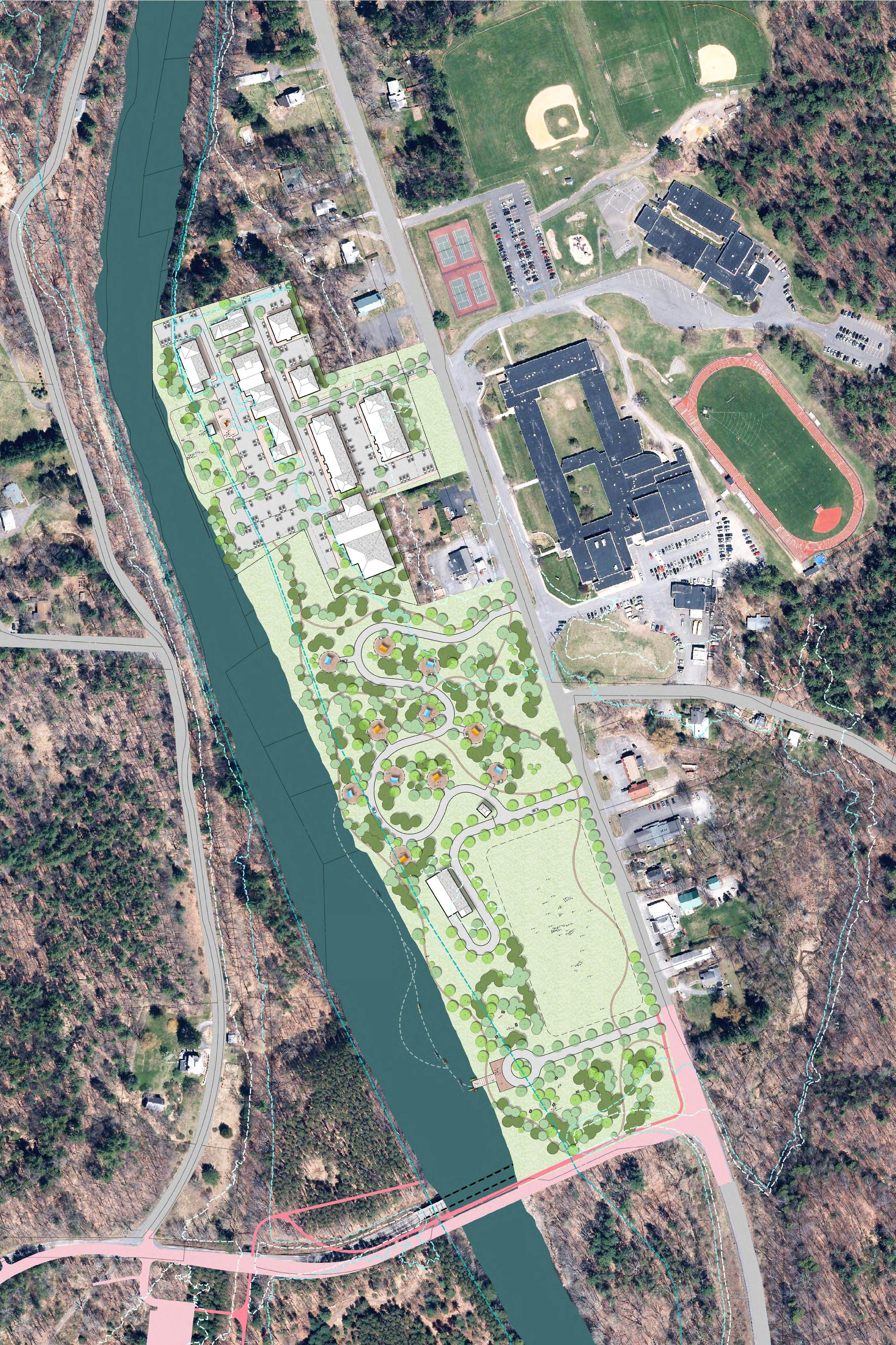
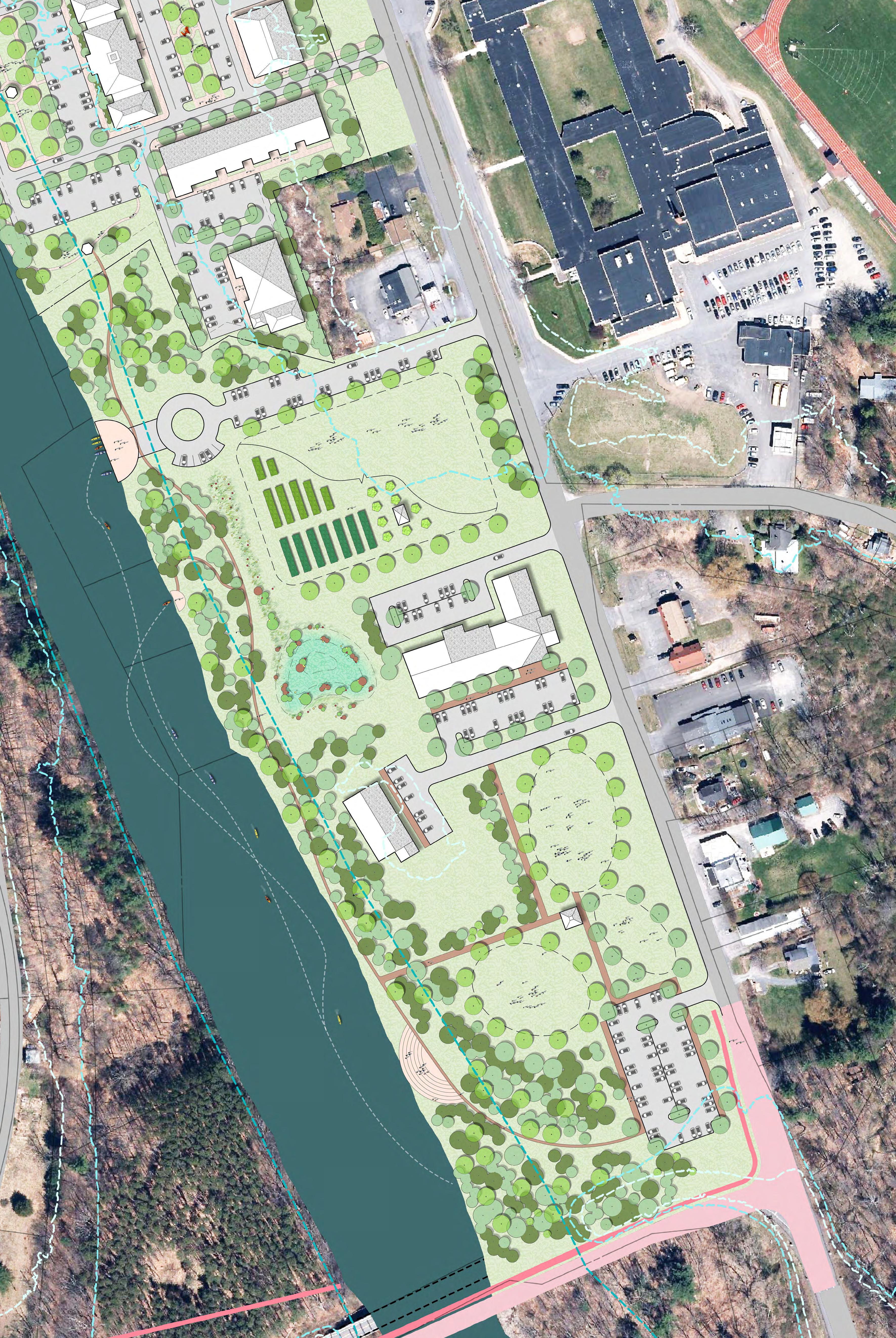
Under the Relocation Plan B design, the IGA supermarket would remain in its current location, and all other businesses would relocate to the north. Under this scenario, 95,130 sf of building space for relocating businesses is incorporated into six separate buildings (See Figure 6-6). All setbacks and parking spaces as required by the zoning code are provided for in this design.
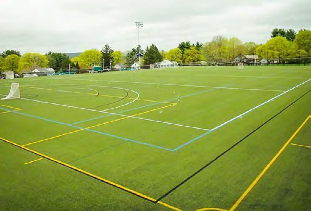
If the supermarket remains in place as assumed for Master Plan B, the options for developing a potential riverfront park or recreation area would be more limited (See Figure 6-7). The supermarket would divide the space into two halves and reduce the continuity of the greenspace. The development of the relocation site in combination with the potential riverfront park under this scenario can be viewed in Figure 6-8. The potential outdoor recreational uses include a stone amphitheater, event space, a pavilion, fishing access, a multiuse trail, a car-top boat put-in/takeout area, or a community garden area.
The Olive Fire Department Company #5 located at 4067 Route 28 in the hamlet of Boiceville has been identified as a critical facility that is located within the 100-year flood zone and has experienced repeated flooding.
Company #5 of the Olive Fire Department expressed its willingness to move the firehouse to a new, less flood-prone location. There are a number of factors to take into consideration when siting a firehouse. These factors include but are not limited to location in relation to other critical facilities, topography, sight distance for vehicles, and speed limit.
In total, nine parcels were identified as possible relocation sites. The sites and the features or constraints of each site are described below:
• Site 1 (36.4-4-4) east of Dancing Rock Road intersection. Topography is steep, and the site is heavily vegetated. On-site stormwater management will need to be designed as the site currently drains to a culvert near the Dancing Rock Road and Route 28 intersection. Based on the roadway speed limit, the sight distance to the east, or the time it will take for a car to reach the proposed property access location, is limited to approximately 10 to 12 seconds.
• Site 2 (36.4-4-5) Located west of the Dancing Rock Road intersection. The site has gently sloping topography. There is good vehicle access and a sight distance of approximately 14 to 16 seconds. There may be a right-of-way issue that would need to be resolved. The parcel is heavily vegetated and smaller in size. On-site stormwater management will need to be designed.
• Site 3 (36.4-1-52.1) Route 28. This site is characterized by steep topography. Sight distance to the east is poor, and oncoming traffic travels at a high speed.
• Site 4 (36.4-1-52.1) Route 28. This site is characterized by a gently sloping topography. This parcel is wet and will require the design of on-site stormwater management. The sight distance to the east is sufficient, but to the west, it is only approximately 7 seconds, and oncoming traffic is traveling at high speeds of 55 to 65 miles per hour.
FIGURE 6-6. R ELOCATION PLAN - B



• Site 5 (36.4-1-52.1) Route 28. This parcel has fairly flat, level topography. There is an adjacent residence. The sight distance to the east is sufficient, but to the west, it is limited, and oncoming traffic is traveling at high speeds of 55 to 65 miles per hour.
• Site 6 (36.4-1-37) – 3974 Route 28. The topography of the site is slightly sloping. The parcel is 1 acre in size. Access to Route 28 is difficult as traversing a side street past a busy business is required. The sight distance to the west is sufficient, but to the east, it is only approximately 3 to 4 seconds, and oncoming traffic is traveling at high speeds of 55 to 65 miles per hour.
• Site 7 (36.11-2-5) – Access to this site is from Upper Boiceville Road. Stormwater management on site would be a concern, and only a small highpoint within the site would be buildable. Sight distance is good, but the turning radius required to back large trucks into the site may not be sufficient. This site would require additional lighting at the intersection between Upper Boiceville Road and Route 28.
• Site 8 (36.4-1-14.1) – Access to this site is difficult. There is a steeply sloped topography at the entrance. This property has a shallow depth, which may constrain development. Sight distance for this site is limited with approximately 7 seconds to the east and 11 seconds to the west.
• Site 9 (36.4-1-14.1) – This site has poor access with a 10- to14-foot-high bank along Route 28. This property has a shallow depth, which may constrain development of the site. The topography of the site slopes toward the reservoir. Stormwater erosion is currently occurring at the outlet of the drainage swale bordering the property. Stormwater runoff is a concern due to the proximity to the reservoir and the direction of drainage toward the reservoir. Sight distance for this site is limited with approximately 7 seconds to the east and 11 seconds to the west.
The assessment considered factors such as distance from other critical facilities within the hamlet; sight distance and traffic speed for vehicle travel to/from the site; and site suitability including topography, drainage, and earthwork required for development. Based on these considerations, site #4 was selected as the preferred option by the Olive Fire Department. The Olive Fire Department is actively applying for funding from the Catskill Watershed Corporation (CWC) to purchase this parcel and relocate the fire department facilities. The Town Board has given official approval for this action to be undertaken as the Fire Department is a critical facility currently located within the 100-year floodplain. A subdivision was approved by the Planning Board, and the Olive Fire Department is purchasing the parcel from the willing seller with funds secured from the CWC Additionally, they are currently seeking grant funds to construct a new fire station/emergency shelter.
For properties where relocation is not a feasible option, "in-place" improvements of individual properties and structures may be appropriate. All practices to protect property within a floodplain must comply with local flood law and obtain the approval of the town floodplain
administrator or code enforcement officer. Potential measures for property protection include the following:
• Elevating the structure
• Floodproofing
• Protecting mechanical, electrical, and plumbing systems
The flood mitigation option to elevate a structure involves the removal of the building structure from the basement and elevating it on piers to a height such that the first floor is located above the level of the 100-year flood event. The basement area is abandoned and filled to be no higher than the existing grade. All utilities and appliances located within the basement must be relocated to the first-floor level or installed from basement joists or similar mechanism at an elevation no less than 1 foot above the base flood elevation. Examples of elevated structures are shown below
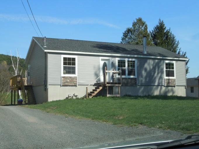
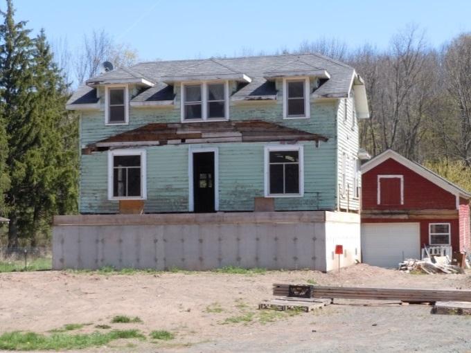
Opportunities to elevate structures are usually limited to smaller structures and to those with shallow to moderate flooding depths In Boiceville, many of the flood-prone buildings, such as the IGA supermarket, are too large to be elevated. Others, such as the medical office building and the firehouse, have uses that require easy, ground-level access and therefore would not be ideal candidates for elevation.
Floodproofing can consist of a variety of measures including dry floodproofing, wet floodproofing, and structural protection measures. These measures are discussed below
Dry floodproofing of the structure to keep floodwaters from entering –Dry flood proofing refers to the act of making areas below the flood level watertight. Walls may be coated with compound or plastic sheathing. Openings such as windows and vents would be either permanently closed or
covered with removable shields. Flood protection should extend only 2 to 3 feet above the top of the concrete foundation because building walls and floors cannot withstand the pressure of deeper water. In Boiceville, some flood-prone buildings would experience flooding depths of 8 feet or more during the 100-year flood event. Floodproofing is typically not an option for buildings when flooding depths are this deep
Wet floodproofing of the structure to allow floodwaters to pass through the lower area of the structure unimpeded – Wet floodproofing refers to intentionally letting floodwater into a building to equalize interior and exterior water pressures. Wet floodproofing should only be used as a last resort. If considered, furniture and electrical appliances should be moved away or elevated above the 100-year flood elevation. The Boiceville Market obtained grant funding from the CWC to conduct a feasibility study to explore the various floodproofing options and associated costs.
The following measures can be undertaken to protect home utilities and belongings:
• Relocate or elevate water heaters, heating systems, washers, and dryers to a higher floor or to at least 12 inches above the base flood elevation (if the ceiling permits). A wooden platform of pressure-treated wood can serve as the base.
• Elevate the electrical box or relocate it to a higher floor and elevate electric outlets to at least 12 inches above the high water mark.
• Relocate valuable belongings above the 100-year flood elevation to reduce the amount of damage caused during a flood event.
• Anchor the fuel tank to the wall or floor with noncorrosive metal strapping and lag bolts.
• Install a backflow valve to prevent sewer backup into the home.
• Install a floating floor drain plug at the lowest point of the lowest finished floor.
• The Town of Olive should identify parcels, as part of a communitywide pollution protection program, that could benefit from securing or relocating fuel tanks to eliminate a potential source of man-made pollution. Funding can be applied for through the CWC. Additionally, the town should work to identify and remove vacant and abandoned structures and their remaining fuel tanks to prevent future hazards.
The LFA (Woidt, 2017) reviewed the alternative of constructing a levee along the banks of the Esopus Creek to protect the commercial hamlet area from flooding. The LFA found that in order for the levee design to meet FEMA accreditation requirements it would have to be sizable with a footprint of 50 to 70 feet in width at the base, a 10-foot-wide crest, and a height of 6 to 9 feet. The levee would also be required to protect all critical infrastructure. In the commercial hamlet area, this includes the firehouse and the WWTP.
The LFA included a conceptual design of the levee. In order for the size requirements of the levee to be met, three buildings would have to be removed. These buildings total over 26,600 sf Relocation of this square footage to an alternate location was not considered. The construction of the levee would also require permanent easements be obtained from several private landowners and across a New York State Department of Transportation (NYSDOT) right-of-way.
For the operation of the levee, a pump station would need to be constructed on the landward side of the levee to drain any interior flooding and keep water depths at 1 foot or less during the design flooding conditions. It was determined that a flap gate would need to be installed on the culvert that runs beneath Route 28. This would cause any floodwaters in that area to back up into the nearby wetland area.
According to the LFA, the cost of constructing a levee is estimated to exceed $3.9 million. In addition to the construction cost, there would be annual maintenance cost associated with the levee, the two pump stations, and the flap gate that is estimated to be between $6,400 and $15,000.
Lastly, the LFA completed the preliminary benefit cost analysis (BCA) short form available from FEMA A BCA is used by FEMA to validate the cost effectiveness of a proposed hazard mitigation project. A BCA is a method by which the future benefits of a project are estimated and compared to its cost. The end result is a Benefit Cost Ratio (BCR), which is derived from a project's total net benefits divided by its total project cost. The BCR is a numerical expression of the cost effectiveness of a project. A project is considered to be cost effective by FEMA when the BCR is 1.0 or greater, indicating that the benefits of the project are sufficient to justify the costs. The construction of a levee was calculated to have a preliminary BCR of 0.63, below FEMA's threshold of 1.0 for a grant application, indicating that FEMA would not fund the levee as conceptualized.
Following Tropical Storm Irene in 2011, the NYC Watershed Stream Management Program developed guidelines for funding flood hazard mitigation projects in the NYC West of Hudson watersheds. The guidelines are explained in the document entitled, "NYC Watershed Stream Management Program Local Flood Analysis (LFA) Program Rules." According to Section D. 5 of the LFA Program Rules, "ineligible projects include: (a) structural flood control practices such as flood walls, berms and levees." As such, funding would not be available from the NYC Stream Management Program, including the CWC and the Ashokan Watershed Stream Management Program
The Town of Olive contracted with Lamont Engineering to review the levee construction alternative that was considered in the LFA. Lamont Engineering found that a levee would not protect critical infrastructure. Under this levee construction scenario, the firehouse would have to be relocated. Since the relocation of the firehouse is currently in the planning phases, this constraint should not pose an issue. To build the levee, however, the WWTP would have to remain waterward of the levee and unprotected by the levee. Leaving this critical facility unprotected does not meet FEMA's accreditation requirements. In addition, Lamont Engineering found that several of the assumptions made within the LFA regarding the materials used to construct the WWTP site were not accurate and may result in greater damage to the WWTP than anticipated.
An additional consideration, as with all levee projects, is that there is always a possibility for a flood event that exceeds the design standards of the levee. A complication for the design of the levee is that it cannot cause a rise of water elevations in the FEMA floodway as FEMA certification is required in order for private property owners to receive reduced flood insurance rates.
In a position paper from the National Society of Professional Engineers (2014), it is noted that there is a great liability exposure for those professional engineers that certify levees. This exposure has led many liability insurance carriers to advise professional engineers that they will lose their liability insurance or sustain a substantial increase in cost if they participate in the levee certification process. Based on this position paper, it may be difficult to locate a professional engineer willing to certify the levee.
Under this alternative, the buildings and infrastructure within the hamlet that are located within the 100-year floodplain will continue to be at risk for flood damages during future flood events. The cost for flood insurance is likely to continue rising and may become too expensive for businesses to continue to afford.
Communities often wonder whether it makes economic sense to remove buildings from the floodplain. These buildings are often subject to severe and/or repeated flood damages due to their location. The cost of rebuilding properties following flood damage is often high. FEMA released a fact sheet entitled, "Building Community Resilience by Integrating Hazard Mitigation. Social and Economic Benefits, "which noted that on average, for every dollar spent on hazard mitigation measures, approximately four dollars in benefits are provided to the US.
A separate study conducted for smaller communities in Vermont identified the benefits of floodplain protection as reduction of flood damages, lower recovery costs, improved health and safety, enhanced ecosystem services, and social benefits. The costs of floodplain protection include possible loss of economic opportunity, possible reduced tax base, floodplain restoration costs, increased costs to floodproof structures, recovery of structures remaining in the floodplain, and cost of demolitions. By closely examining individual communities, this same study found that the benefits of floodplain protection outweigh the costs over the long term when accounting for high value ecosystem services such as floodplain protection One concern with removal of existing buildings from the floodplain is the loss of tax revenue. This loss may often be offset by relocating the building to another suitable location within the municipality but outside of the floodplain. In addition, it was calculated that the greatest economic benefit is realized by a community when buildings are removed from the floodplain. Other individualized methods including floodproofing can provide an economic benefit but to a lesser degree. (Schiff, 2015).
Rough order-of-magnitude relocation costs were estimated based on a series of cost assumptions for land acquisition, construction, and site work. Tax information was obtained from the Ulster County GIS website, which indicated the full market value of each property in the relocation site. The current value of the relocation site properties is $541,200. Construction costs for the Master Plans were held constant at $125 per square foot, and site work was estimated to be 10 percent of the construction cost. For Plan A, which assumes all buildings were relocated, the rough orderof-magnitude relocation costs were estimated to be $16.7 million. For Plan B, which assumes that the current IGA supermarket remains in its current location, the rough order-of-magnitude relocation costs were estimated to be $13.6 million. The cost estimates assume that nearly all of the existing square footage within the Boiceville Commercial District is replaced regardless of
whether it is occupied or not. If only occupied square footage were taken into account, the square footage of the buildings needed in the Master Plans and construction costs would be reduced.
The properties within the 100-year flood zone have a combined market value of $5.07 million as of 2019. The cost of new construction is significantly higher than the current market value of the properties. The gap between current market value and estimated relocation costs may deter some property owners from relocating to new construction and may encourage them to floodproof in place or relocate to an existing building outside of the 100-year flood zone. Costs are summarized in Table 6-1.
Several funding sources may be available to the Town of Olive for the implementation of recommendations made in this report.
The LFA program that funded the LFA for the Town of Olive is one potential funding vehicle for some of the alternatives described in this report. As described in the LFA rules, "Stream Management Programs in the New York City water supply watersheds and the Catskill Watershed Corporation are supporting the analysis of flood conditions and the identification of hazard mitigation projects. The process consists of two steps: 1) an engineering analysis of flood conditions and identification of potential flood mitigation projects articulated in a plan and 2) project design and implementation. The engineering analysis and plan are termed 'Local Flood Analysis.' These program rules define the process for municipalities to apply for funding to complete a Local Flood Analysis (LFA). These program rules also define the process for municipalities to seek funding from the Stream Management Program to implement projects that involve streams, floodplains, and adjacent infrastructure to reduce flood hazards.” LFA Program Rules can be viewed at: http://catskillstreams.org/wp-content/uploads/2015/01/LFA_Rules.pdf
Buyout programs are used to acquire individual flood-damaged properties that are associated with a mitigation project and have the potential for reducing future flood damages. Buyout programs are also a means of helping residents to relocate from properties that are repeatedly damaged by floods. Several properties within the hamlet of Boiceville are currently participating in the NYCDEP-funded flood buyout program, and several additional properties have been identified for acquisition funded under this program, if the owner were willing to participate. At the time of preparing this report, the NYCDEP-funded flood buyout program is proposed to assist communities with purchasing flood-damaged properties. The program guidelines are documented in the April 2014 publication, "A Plan for the New York City Funded Flood Buyout Program." The NYCDEP-funded flood buyout program is a city-funded program that creates a process for the acquisition of flood-damaged or flood-threatened properties, particularly properties with structures, from willing sellers. The structures on the properties are removed, and the properties are restored or allowed to revert to a natural condition.
The properties cannot be purchased without local municipal support. The municipalities are given the opportunity to own the property, but NYC will take ownership if the municipality is not interested in ownership. In addition, management agreements can be created if the municipality wishes to see the property actively managed. The properties are purchased for fair market value, and eligible parcels can be identified in an LFA or similar formal process. Ultimately, the properties are protected with a conservation easement.
Another program is the FEMA buyout program. NYC will encourage property owners to participate in this program when that option is available. The FEMA program activates when a disaster zone is declared following a flooding event. Federal monies are then allocated through the NYS Office of Emergency Management to local communities. The NYC Funded Flood Buyout
Program will not be available to properties that are deemed eligible for the FEMA buyout program.
The CWC is a not-for-profit local development corporation established to protect the water resources of the New York City watershed west of the Hudson River, preserve and strengthen communities located in the region, and increase awareness and understanding of the importance of the New York City water system. CWC administers a number of programs under this mission such as the following:
Septic Repair and Maintenance – Funds residential septic system repairs, replacements, and maintenance
Stormwater Planning and Control – Funds planning, assessment, design, and implementation of stormwater and erosion controls for existing conditions as well as stormwater requirements for new construction
Education – Provides grants to schools and organizations
Community Wastewater Management – Funds a program to evaluate and build community‐specific wastewater solutions, which may include septic maintenance districts, community septic systems, or wastewater treatment plants
Local Technical Assistance Program – Provides grants for planning updates for proposed relocations in communities that have completed an LFA
Economic Development – The Catskills Fund for the Future provides low interest loans to businesses located within the New York City West of Hudson Watershed.
The Flood Hazard Mitigation Implementation Program (FHMIP) is intended to help fund projects such as property protection measures, floodplain reclamation, public infrastructure protection, communitywide elimination of potential sources of pollution, and property buyout/relocation. Most projects must be identified through an LFA conducted in Watershed municipalities by consultants funded by New York City Department of Environmental Protection's Stream Management Program or consultants engaged through other flood response programs.
Where projects include relocations of homes and businesses and the corresponding need to relocate sewer infrastructure, the city will support the use of funding either for on-site sewage disposal or extensions of city-owned wastewater treatment plants, or to wastewater treatment plants not owned by the city, based on what solutions are most cost effective. If a relocation results in sewer extension, the city will make funding available to ensure that the sewer charges are comparable to what they would be under the New Infrastructure and Community Wastewater Management Programs.
Municipalities with completed LFAs may apply to the CWC for funds to implement projects recommended in those analyses. Grant rounds are twice per year. Initial grant rounds have been scheduled for June 1 and December 1 each year. Funding guidelines are described in the CWC's FHMIP rules and are available on CWC's website: www.cwconline.org.
A related program was approved by the CWC Board of Directors in December 2014. The Sustainable Communities Planning Program, part of the Local Technical Assistance Program, is
intended to fund revisions to local zoning codes or zoning maps or to upgrade comprehensive plans in order to identify areas within those municipalities that can serve as new locations for residences and/or businesses to be moved after purchase under the voluntary NYC Flood Buyout Program. Grants of up to $20,000 are available through this program.
Through the EWP program, the U.S. Department of Agriculture's Natural Resources Conservation Service (NRCS) can help communities address watershed impairments that pose imminent threats to lives and property. Most EWP work is for the protection of threatened infrastructure from continued stream erosion. NRCS may pay up to 75 percent of the construction costs of emergency measures. The remaining costs must come from local sources and can be made in cash or in-kind services. EWP projects must reduce threats to lives and property; be economically, environmentally, and socially defensible; be designed and implemented according to sound technical standards; and conserve natural resources. These monies are not available at all times –only after Congressional allocations following federal disasters.
The projects described in this report are not ideal matches for the NRCS EWP program. However, future use of the EWP program should be considered if the program rules change.
FEMA and its partners are working on the development and implementation of DRRA Section 1234: National Public Infrastructure Pre-Disaster Hazard Mitigation Grant Program. This program, which FEMA has named Building Resilient Infrastructure and Communities (BRIC), will be funded through the Disaster Relief Fund as a six percent set aside from estimated disaster grant expenditures. FEMA’s official announcement of this new funding is likely to occur in late 2019, with the anticipated application period opening in 2020.
The HMGP is authorized under Section 404 of the Robert T. Stafford Disaster Relief and Emergency Assistance Act. The HMGP provides grants to states and local governments to implement long-term hazard mitigation measures after a major disaster declaration. The purpose of the HMGP is to reduce the loss of life and property due to natural disasters and to enable mitigation measures to be implemented during the immediate recovery from a disaster. A key purpose of the HMGP is to ensure that any opportunities to take critical mitigation measures to protect life and property from future disasters are not "lost" during the recovery and reconstruction process following a disaster.
The FMA program was created as part of the National Flood Insurance Reform Act (NFIRA) of 1994 (42 U.S.C. 4101) with the goal of reducing or eliminating claims under the NFIP. FEMA provides FMA funds to assist states and communities with implementing measures that reduce or eliminate the long-term risk of flood damage to buildings, homes, and other structures insurable under the NFIP. The long-term goal of FMA is to reduce or eliminate claims under the NFIP through mitigation activities. Several recent Acts have resulted in changes to this program.
One limitation of the FMA program is that it is used to provide mitigation for structures that are insured or located in the 100-year flood zone. Therefore, the individual property mitigation options described in this report are best suited for FMA funds. Like PDM, FMA programs are subject to the availability of appropriation funding as well as any program-specific directive or restriction made with respect to such funds.
NYS Department of State (DOS)
The DOS may be able to fund portions of some of the scenarios described in this report. In order to be eligible, a project should link water quality improvement to economic benefits. NYS DOS grant opportunities are available on the website at: https://www.dos.ny.gov/funding/index.html
U.S. Army Corps of Engineers (USACE)
USACE provides 100 percent funding for floodplain management planning and technical assistance to states and local governments under several flood control acts and the Floodplain Management Services (FPMS) Program. Specific programs used by the USACE for mitigation are listed below.
Section 205 – Small Flood Damage Reduction Projects: This section of the 1948 Flood Control Act authorizes USACE to study, design, and construct small flood control projects in partnership with nonfederal government agencies. Feasibility studies are 100 percent federally funded up to $100,000, with additional costs shared equally. Costs for preparation of plans and construction are funded 65 percent with a 35 percent nonfederal match. In certain cases, the nonfederal share for construction could be as high as 50 percent. The maximum federal expenditure for any project is $7 million.
Section 206 – Floodplain Management Services: This section of the 1960 Flood Control Act, as amended, authorizes USACE to provide a full range of technical services and planning guidance necessary to support effective floodplain management. General technical assistance efforts include determining the following: site‐specific data on obstructions to flood flows, flood formation, and timing; flood depths, stages, or floodwater velocities; the extent, duration, and frequency of flooding; information on natural and cultural floodplain resources; and flood loss potentials before and after the use of floodplain management measures. Types of studies conducted under FPMS include floodplain delineation, dam failure, hurricane evacuation, flood warning,
floodway, flood damage reduction, stormwater management, floodproofing, and inventories of flood‐prone structures. When funding is available, this work is 100 percent federally funded.
In addition, USACE provides emergency flood assistance (under Public Law 84-99) after local and state funding has been used. This assistance can be used for both flood response and postflood response. USACE assistance is limited to the preservation of life and improved property; direct assistance to individual homeowners or businesses is not permitted. In addition, USACE can loan or issue supplies and equipment once local sources are exhausted during emergencies.
Community Development Block Grant (CDBG) – The Office of Community Renewal administers the CDBG program for the State of New York. The NYS CDBG program provides financial assistance to eligible cities, towns, and villages in order to develop viable communities by providing affordable housing and suitable living environments as well as expanding economic opportunities principally for persons of low and moderate income. It is possible that CDBG funding program could be applicable for floodproofing and elevating residential and nonresidential buildings, depending on the eligibility of those buildings relative to the program requirements.
Empire State Development – The state's Empire State Development program offers loans, grants, and tax credits as well as other financing and technical assistance to support businesses and encourage their growth. It is possible that the program could be applicable for floodproofing, elevating, or relocating nonresidential buildings, depending on eligibility of those businesses relative to the program requirements.
Private Foundations – Private entities such as foundations are potential funding sources in many communities. The Flood Advisory Committee will need to identify the foundations that are potentially appropriate for some of the actions proposed in this report.
Cornell Cooperative Extension – Ulster County et al., Upper Esopus Creek Management Plan Volume 1. January 2007
FEMA (2016) Flood Insurance Study, Ulster County, New York (All Jurisdictions). Federal Emergency Management Agency Flood Insurance Study Number 36111CV001B. Effective November 18, 2016 (Revised)
Milone & MacBroom, Inc. (2015). "Evaluating the Costs and Benefits of Floodplain Protection Activities in Waterbury, Vermont and Willsboro, New York, Lake Champlain Basin, U.S.A"
New York City Department of Environmental Protection (NYCDEP) (2010). "DEP Completes Boiceville Wastewater Treatment Plant." https://www1.nyc.gov/html/dep/html/press_releases/1075pr.shtml#.XFCSxFVKhhF
New York State Department of Environmental Conservation (NYSDEC) Environmental Resource Mapper. 2018. http://www.dec.ny.gov/gis/erm/
NYSDEC, NYS Section 303(d) List of Impaired/TMDL Waters. 2019. http://www.dec.ny.gov/chemical/31290.html
NYSDEC, Waterbody Inventory/Priority Waterbodies List. 2019. http://www.dec.ny.gov/chemical/36730.html
Town of Olive Laws, Chapter 155, Zoning. Adopted 1975, with amendments
Town of Olive Laws, Chapter 97, Flood Damage Prevention. Adopted 2016, with amendments
URS for Ulster County Department of Emergency Communications/Emergency Management. Multi-Jurisdictional Natural Hazard Mitigation Plan, Ulster County, New York. February 2009
Ulster County Parcel Viewer. 2019 http://ulstercountyny.gov/maps/parcel-viewer/
Woidt Engineering & Consulting. Local Flood Analysis, Flood Engineering Analysis Report, Hamlets of Boiceville and West Shokan, Town of Olive, Ulster County, New York. December 2016 (Revised as late as August 8, 2017)
5909-02-01-n1219-rpt.docx
Boiceville Land Use Planning Feasibility Study 40 November 2019
Central to maintaining NYCDEP's Filtration Avoidance Determination (FAD) is a series of partnership programs between NYC and the upstate communities along with the set of rules and regulations administered by the NYCDEP. As required in the FAD, Stream Corridor Management Plans are developed and implemented under the Stream Management Program. The Esopus Creek Stream Management Plan (SMP), volume 1 (2007) was developed by the Ulster County Cornell Cooperative Extension, NYCDEP, and USACE Research Development Center. One component of the SMP is the preservation of water quality through effective management of the streams and associated floodplains that feed water supply reservoirs. The Olive town board adopted the plan on January 12, 2010.
The SMP provides a framework for general stream management decision making in the watershed. The plan provides documentation of current stream conditions along the Upper Esopus Creek and a broad assessment of the condition of existing infrastructure. The SMP contains data from a Stream Features Inventory that was performed from 2005 to 2006.
The SMP states that, "large flood events on Esopus Creek have high economic costs." General recommendations for the entire watershed include, but are not limited to, avoiding future development in areas subject to flood damages, installing floodproofing and other measures to reduce damages where existing infrastructure is at risk, and developing an early warning system and a more coordinated and timely flood response. Specific recommendations for the hamlet of Boiceville were not part of this report.
The Ulster County Multi-Jurisdictional Hazard Mitigation Plan (HMP) was developed by the Ulster County Multi-Jurisdictional Hazard Mitigation Plan Team with assistance from URS Corporation. The HMP was approved by FEMA and became effective February 2009. The Town of Olive participated in the 2017 update to the plan. The following discussions are taken from the HMP.
Flooding is ranked as the primary natural hazard in New York State. For Ulster County, flooding was ranked 3rd out of 27 hazards and was categorized as a "Moderately High Hazard," which indicates that "death and injuries are likely and that damages and impacts could have severe impacts for the community." According to the HMP, it has been calculated that 7% of all properties in Ulster County are located within the 100-year floodplain, and of the 62 counties within the state, Ulster County is the 10th most threatened and vulnerable county to flood loss.
All municipalities that participated in the HMP, including the Town of Olive, participate in the NFIP, which "aims to reduce the impact of flooding… by providing affordable insurance to property owners and by encouraging communities to adopt and enforce floodplain management regulations." (http://www.fema.gov/national-flood-insurance-program, 2016). According to the HMP, there are 6,502 acres in the town of Olive that are located within the 100-year floodplain or nearly 16% of the land within the town. For the town of Olive, the property located within the high hazard or 100-year floodplain has an estimated value of nearly $47 mill. In total, there have been 15 NFIP claims resulting in payments of $63,791 since 1978. The HMP states that, "actual flood losses community-wide are likely to be higher since this value only includes NFIP payouts
Boiceville Land Use Planning Feasibility Study
November 2019
and does not include losses incurred by non-policy holders, losses for which a claim was not submitted, or losses for which a payment on a claim was denied" (HMP, 2009). According to the HMP, there are no properties in Olive that the NFIP categorizes as Repetitive Loss Properties, or "properties that have been repeatedly flooded and where multiple claims for flood losses have been made through the NFIP fund" (HMP, 2009).
The HMP identifies strategies for the communities to mitigate the hazards identified. Strategies identified within the HMP include the following:
Limit uses in floodways to those tolerant of occasional flooding, including but not limited to agriculture, outdoor recreation, and natural resource areas.
Develop a countywide gauging and warning system for flash and riverine flooding.
Continue to implement best management practices for floodplain areas.
Identify and document repetitively flooded properties. Explore mitigation opportunities for repetitively flooded properties, and if necessary, carry out acquisition, relocation, elevation, and floodproofing measures to protect these properties.
Conduct a routine stream maintenance program and seek financial assistance to clean out stream segments with heavy sediment deposits.
Develop specific mitigation solutions for flood-prone roadways and intersections.
Implement projects to decrease "flash" in streams during/after storm events.
Implement specific actions to enhance/improve participation in/compliance with NFIP
The current FEMA FIS for Ulster County is a preliminary report dated May 24, 2013. The FIS covers all jurisdictions in the county, inclusive of the town of Olive. The purpose of the FEMA FIS is to determine potential floodwater elevations and delineate existing floodplains in order to identify flood hazards and establish insurance rates. For the subject study area, the FIS includes a detailed study of Esopus Creek. The hydrologic and hydraulic analyses utilized in this report were completed in November 1982 by the New York District of USACE.
An important byproduct of the FIS is a series of Hydrologic Engineering Center – River Analysis System (HEC-RAS) computer models that are available for professional use and are an important component of any flood analysis study. A key element of the HEC-RAS analysis is the determination of the area flooded during the 100-year frequency event, referred to as the 100year flood zone. A detailed HEC-RAS model was created for Esopus Creek.
In order to fulfill requirements of the Federal Clean Water Act, the NYSDEC must provide periodic assessments of the quality of the water resources in the state and their ability to support specific uses. These assessments reflect monitoring and water quality information drawn from a number of programs and sources both within and outside the department. This information has been compiled by the NYSDEC Division of Water and merged into an inventory database of all water bodies in NYS. The database is used to record current water quality information, characterize known and/or suspected water quality problems and issues, and track progress toward their resolution.
November 2019
This inventory of water quality information is the division's Waterbody Inventory/Priority Waterbodies List (WI/PWL). While the lower and middle segments of the Esopus Creek are listed within the WI/PWL for minor impacts, the upper section of the Esopus Creek is not listed in the WI/PWL report.
The NYS Section 303(d) List of Impaired Waters (2012, revised 2013) identifies those waters that do not support appropriate uses and that may require development of a Total Maximum Daily Load (TMDL). The Upper Esopus Creek is listed as impaired for silt/sediment due to stream bank erosion.
The NYSDEC Water Quality Standards and Classifications program is responsible for setting NYS ambient water quality standards and guidance values for surface water and groundwater. The program is also responsible for the classification of surface waters for their best usage. The water quality standards program is a state program with Environmental Protection Agency (EPA) oversight. New York's longstanding water quality standards program predates the federal Clean Water Act and protects both surface water and groundwater. All waters in NYS are assigned a letter classification that denotes their best uses. Letter classes such as A, B, C, and D are assigned to fresh surface waters. Esopus Creek, as it passes through the hamlet of Boiceville, is a Class A(TS) stream. Class A indicates waters that are suitable as a source of water supply for drinking, culinary, or food processing purposes; primary and secondary contact recreation; and fishing. The waters shall be suitable for fish, shellfish, and wildlife propagation and survival. Class A waters are regulated by NYS. The standard of (TS) indicates that the waters may support trout spawning (TS), and special requirements apply to sustain these waters that support these valuable and sensitive fisheries resources.
An LFA was prepared for the Town of Olive by Woidt Engineering & Consulting, PC in 2016, with revisions made in 2017. The LFA analyzed the Esopus Creek at Boiceville and the Bushkill at West Shokan areas. The Boiceville Study Area overlaps with the area of concern for this subject report. For this study area, the effects of the Route 28A bridge on flooding were analyzed. The LFA identified critical infrastructure within this study area including the Firehouse Company #5, the Boiceville Market, and the Wastewater Treatment Plant. The LFA notes that the Route 28A bridge is due to be replaced within 5 years. The LFA was performed in collaboration with the preliminary bridge design to ensure that flooding would not be exacerbated.
As noted in the Town of Olive LFA (2016), the town does not have an official comprehensive planning document. A draft version was developed in 1975, 1995, and 2011, but none were adopted by the Town Board.
The Town of Olive adopted a Flood Damage Prevention law in 1984 and later updated the law in 1987. It was further amended in 1989 and 2016.
November 2019
Chapter 97 of the Olive Town Code – The stated purposes of this local law are as follows:
• Regulate uses that are dangerous to health, safety, and property due to water or erosion hazards or which result in damaging increases in erosion or in flood heights or velocities.
• Require that uses vulnerable to floods, including facilities that serve such uses, be protected against flood damage at the time of initial construction.
• Control the alteration of natural floodplains, stream channels, and natural protective barriers which are involved in the accommodation of flood waters.
• Control filling, grading, dredging, and other development that may increase erosion or flood damages.
• Regulate the construction of flood barriers that will unnaturally divert flood waters or which may increase flood hazards to other lands.
• Qualify and maintain for participation in the National Flood Insurance Program.
The stated objectives of the local law are as follows:
• To protect human life and health
• To minimize the expenditure of public money for costly flood-control projects
• To minimize the need for rescue and relief efforts associated with flooding and generally undertaken at the expense of the general public
• To minimize prolonged business interruptions
• To minimize damage to public facilities and utilities such as water and gas mains, electric, telephone and sewer lines, streets and bridges located in areas of special flood hazard or the 100-year flood zone
• To help maintain a stable tax base by providing for the sound use and development of areas of special flood hazard or the 100-year flood zone so as to minimize future flood blight areas
• To provide that developers are notified that property is in an area of special flood hazard or the 100-year flood zone
• To ensure that those who occupy the areas of special flood hazard assume responsibility for their actions
The Town Code Enforcement Officer/Building Inspector is empowered as the Local Administrator and is responsible for administering and implementing the local Flood Damage Prevention code. It is the duty of the local administrator to grant or deny floodplain development permits in accordance with the code. The local administrator must conduct a permit application review prior to approval and must review the subdivision or other proposed new development to determine if the proposed site is reasonably safe from flooding. It is also his/her responsibility to determine if proposed development in an area of special flood hazard may result in physical damage to other property.
The local law identifies a series of Construction Standards for development in the floodplain and is broken down into General Standards, Standards for All Structures, Residential Structures, NonResidential Structures, and Manufactured Homes and Recreational Vehicles. The mapped FEMA flood zones are utilized to guide many of the regulations. For reference, the 100-year flood zones indicate all areas within the 1 percent annual chance flood zone, Zone A indicates the approximated 1 percent annual chance flood zone, Zones AE and A1-30 indicate the calculated 1
percent annual chance flood zone, Zone AH is a 1 percent annual chance flood zone where shallow ponding occurs, and Zones X and C are outside of the 100-year flood zone
The General Standards section is broken down into standards for subdivision proposals and encroachments. These standards apply to both new development and substantially improved structures. All new subdivision proposals and other development proposed in a special flood hazard area must be consistent with the need to minimize flood damage. Public utilities and facilities should be located or constructed in order to minimize flood damage, and adequate drainage should be provided. When encroaching within Zones A1-A30 and AE along streams without a regulatory floodway, development must not increase the base flood elevation by more than 1 foot. Along streams with a regulatory floodway, development must not create any increase in the base flood elevation.
Standards for all structures include provisions for anchoring, construction materials and methods, and utilities. New structures must be anchored so as to prevent flotation, collapse, or lateral movement during the base flood. Construction materials must be resistant to flood damage, and construction methods must minimize flood damage. Enclosed areas below the lowest floor in zones A1-A30; AE; AH; and in some cases Zone A must be designed to allow for the entry and exit of floodwaters. Utility equipment such as electrical, HVAC, and plumbing connections must be elevated to or above the base flood height. Water supply and sanitary sewage systems must be designed to minimize or eliminate the infiltration of floodwaters.
The elevation of residential and nonresidential structures is required in areas of special flood hazard. In zones A1-A30; AE; AH; and in some cases Zone A, new residential construction and substantial improvements must have their lowest floor (including basement) elevated to an elevation that is 2 feet above the base flood elevation. In cases where base flood elevation data is not known for Zone A, new residential construction and substantial improvements must have their lowest floor elevated to 3 feet above the highest adjacent grade.
For nonresidential structures in zones A1-A30; AE; AH; and in some cases Zone A, developers have the option of either elevating the structures or making improvements to the structure such as floodproofing the structure to 2 feet above the base flood elevation. In cases where base flood elevation data is not known within Zone A, new construction and substantial improvements must have their lowest floor elevated to 3 feet above the highest adjacent grade.
Recreational vehicles are only allowed in zones A1-A30, AE, and AH if they are on site fewer than 180 consecutive days and are licensed and ready for highway use or meet the construction standards for manufactured homes. Manufactured homes in the A1-A30, AE, and AH zones must be placed on a permanent foundation with the lowest floor elevated 2 feet above the base flood elevation. In Zone A, such structures must be placed on reinforced piers or similar elements that are at least 3 feet above the lowest adjacent grade.
5909-02-01-n1219-rpt.docx