
2 minute read
Community Understanding

from East Chicago Boards
by MKSK

4 | COMMUNITY UNDERSTANDING
What we’ve learned about East Chicago
Community Economic Development Goals:
1Attracting developers, new business and employers to
East Chicago by aggressively enhancing the city’s profile and highlighting available resources such as water, power, transportation and technology infrastructure, as well as the city’s attractive financial incentives. 2 Manage local revitalization projects and redevelopment ventures while working to retain and expand existing business and generally accelerate the growth of business within the city.
We’ve studied previous and current town and regional plans, demographics, and physical attributes of the town.
CREATE A USER-FRIENDLY TRANSIT HUB FOR ALL MODES
Transform Indianapolis Boulevard and Michigan Street into pedestrian-oriented mixed-use corridors with neighborhood amenities
Create a station hub that accommodates all modes, including services for bicycles
Establish Roxana Marsh as nature and recreation amenity while protecting the natural environment with infrastructure enhancements
Ensure compatibility among uses especially between industrial uses and neighborhood areas
Capitalize on city’s strategic regional location, strong transportation connections, industrial legacy, historic character, and land use potential
Expand/interconnect system of parks and open space city-wide
Create development-ready sites to attract economic growth, especially office/industrial parks, distribution centers, large-scale office centers, etc.
Consolidate and concentrate retail within established cores of existing commercial districts with a focus on serving neighborhoods and supporting local, independent businesses

ENHANCE PARKS AND TRAILS AND CAPITALIZE Roxana Plan | 2017ON REDEVELOPMENT OPPORTUNITIES
EAST CHICAGO COMPREHENSIVE PLAN (2008)

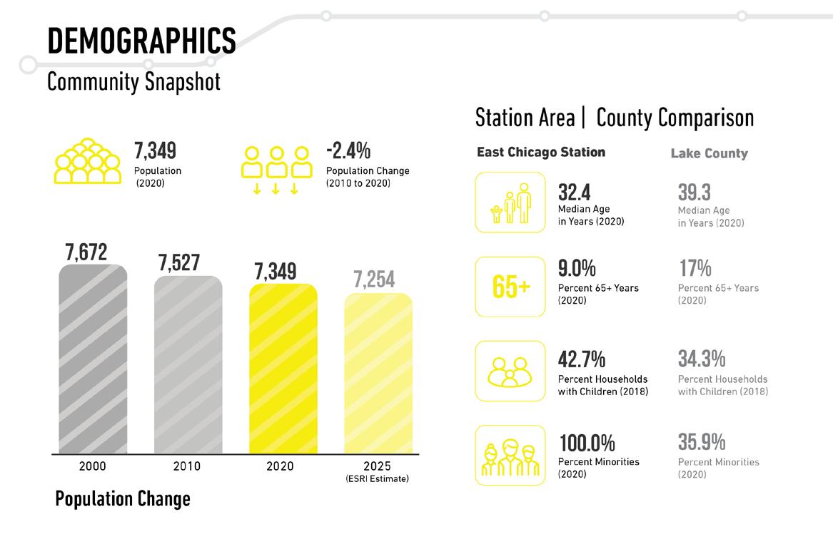
DEMOGRAPHICS

The community snapshot of demographic information included population change, age, and race traits.
The community snapshot of housing information included household characteristics, residential unit types and housing market traits.

The community snapshot of employment information included top employment sectors, education, and household income. East Chicago, IN Public Gallery For Community Feedback

CONNECTIVITY

The community snapshot for transportation information included ways of traveling to work, vehicle ownership, and time spent traveling to work.

These walksheds illustrate the areas within five-, ten-, and fifteen-minute walking time from the station area.

The station area is connected to the community via major corridors, such as Indianapolis Boulevard and Michigan Street, as well as proximity to I-90.

