
11 minute read
OVERVIEW

Introduction
This book categorizes and illuminates the stylistic attributes of the houses in Fairmount Heights, Maryland. Fairmount Heights is a historically African-American suburban town located in Prince George’s County along its border with Washington, D.C. This book identifies over 500 single-family dwellings, classifies and maps them by style and dates of construction, and provides photographs of each. It identifies unimproved lots and offers five new dwelling designs that are compatible with the existing town character. It builds upon and is a companion to the 1990 Fairmount Heights, Maryland, A History from its Beginnings (1900) to its Incorporation (1935) and the 1993 Fairmount Heights, Maryland Residential Façade and Improvement Guidelines, the latter of which is being reprinted and reissued with this publication.
Not included in this pattern book are commercial and multifamily buildings, townhouses, churches, single-family dwellings repurposed for commercial uses, commercial buildings repurposed for singlefamily use, and land owned by The Maryland-National Capital Park and Planning Commission (M-NCPPC)1. Generally, property that is not zoned RSF-65 ( Residential, Single Family, 65) is not included; the exceptions are the single-family dwellings on Eastern Avenue near its intersection with Sheriff Road where the land is zoned IE (Industrial, Employment).2
Why a Pattern Book?
Seeking a framework on which to encourage restoration, compatible additions, and new dwelling construction, in 1991 the Town of Fairmount Heights applied for a set of design guidelines through M-NCPPC’s Planning Assistance to Municipalities and Communities (PAMC) program. The Fairmount Heights, Maryland Residential Façade and Improvement Guidelines, prepared by M-NCPPC’s Community Planning Division, was published in 1993. In 2019 the town applied and was accepted for an updated guide, again using the PAMC program. In planning for a new publication, M-NCPPC staff considered what information not found elsewhere would be most valuable and interesting for this town-specific publication.
1 In general, M-NCPPC acquires and retains land for conservation, transportation, or public recreation (see Maryland Code, Land Use Article, Section 17-101[b]). M-NCPPC does not acquire property intending to convey it to a private property owner; real property does not transfer to M-NCPPC, and ultimately to a private buyer, if a property owner fails to pay property taxes. For those reasons, staff did not consider any M-NCPPC property as a potential site for new single-family dwelling construction. However, staff identified some property under town or County ownership (such as that owned by the Redevelopment Authority) as suitable sites for infill development. 2 The IE (Industrial, Employment) Zone accommodates limited residential development. Zoning Ordinance, 27-4203(e).
Project staff determined the original publication had sound preservation, restoration, and additions advice—and exceptionally good illustrations—and should be reprinted. What it lacked was an inclusive and explanatory survey of the diverse single-family dwelling resources that comprise most of the town, and fresh ideas for compatible new houses. This book is based on new survey data. Each extant single-family dwelling in the town has been mapped geospatially using ArcGIS, photographed, and classified by style. In some instances, new research was undertaken on subdivisions and original or early owners that help illuminate the town’s history and patterns of development. Certain unimproved properties, including those once occupied by a house, were identified as potential locations for infill construction. There are 514 surveyed dwellings and 68 identified buildable parcels.3 With the belief the “domestic architecture [stands] at the very core of the American experience,”4 the goal of this book is to offer something for everyone.
How to Use this Pattern Book
This book is a planning tool for homeowners, builders, planners, historians, students, and developers so that they can familiarize themselves with the historic patterns of development and dwelling styles in Fairmount Heights, and plan and design new dwellings compatible with the neighborhoods. The pattern book builds on previous planning work and studies undertaken by M-NCPPC for Fairmount Heights, including the 1990 Fairmount Heights, Maryland, A History from its Beginnings (1900) to its Incorporation (1935); the 1993 Fairmount Heights, Maryland Residential Façade and Improvement Guidelines; the 1996 African-American Heritage Survey; the 2003 African-American Historic Resources in Prince George’s County, Maryland Multiple Property Documentation; the 2010 Approved Historic Sites and District Plan; the 2010 Approved Subregion 4 Master Plan; the 2011 Fairmount Heights National Register Historic District nomination; and the 2012 African-American Historical and Cultural Resources in Prince George’s County.
This Pattern Book contains new historical analysis and maps of the subject residential neighborhood over the past 122 years. Property owners can use this information to understand the many architectural styles that comprise the neighborhoods, identify individual house styles, plan for new construction, plan for additions, renovations, and rehabilitation or preservation work. It should be used in conjunction with the republished 1993 Fairmount Heights, Maryland Residential Façade and Improvement Guidelines, which has detailed information on the components of dwelling elements such as windows, doors, siding types, and roofs found in Fairmount Heights.
Students and historians can use this information and sources gathered herein as inspiration for further studies and research to shed light on the people, built environment, and social and economic history of Fairmount Heights. Potential topics include: • Mortgage and lending practices for African-American homebuyers and builders • African-American-founded improvement societies • The Modern Movement and African-American homebuyers • Washington, D.C., and its relationship to Fairmount Heights • White House staff who were Fairmount Heights residents • Fairmount Heights first families, their origins, occupations, and dwellings • Persistence and change in dwelling ownership and styles • Surges and ebbs in Fairmount Heights development • Veterans of Fairmount Heights
3 The lots in the 1900 Fairmount Heights subdivision were 25 feet wide; properties suitable for a new single-family dwelling now comprise at least two lots. Note also that development in the town continues even as this book was being written and published, so some property identified as vacant may already be improved with a new dwelling. 4 Alastair Gordon, Romantic Modernist: The Life and Work of Norman Jaffe, Architect, (New York: The Monacelli Press, 2005), 11.
The National Register of Historic Places
The Town of Fairmount Heights was listed in the National Register of Historic Places in 2011. The listing’s effect on property owners is largely honorary and entirely nonregulatory.5 The designation includes a comprehensive list of all residential and commercial buildings, sites and structures within the boundary and categorizes them as contributing to the significance of the district, or as noncontributing: properties that do not contribute to the significance of the district.6 This pattern book makes no distinction between contributing and noncontributing properties.
The National Register boundary corresponds with the municipal boundary, with two exceptions: it does not include an 11-acre, 10-parcel section at the northeast corner of Sheriff and Addison Roads comprising mostly undeveloped property owned by M-NCPPC and the town; and includes an approximately 6-acre portion southeast of the town’s southern boundary that is part of the City of Seat Pleasant. Properties outside the municipal boundary but included in the National Register boundary are not part of the inventory for the purposes of this publication.
The Maryland Inventory of Historic Properties
Representation in the Maryland Inventory of Historic Properties (MIHP) means a property has been documented for the inventory, for whatever purpose (for example, because a potential state or federal undertaking could destroy it). Some properties in the inventory may also be designated as a County historic site or historic resource (see following section). If a property is listed in the inventory but is not a County historic site or historic resource, its inventory number is provided as follows: PG:72-9-00. The County is represented by PG, the planning area is 72, 9 is the Fairmount Heights Survey Area, and the final number is the individual inventory number. No leading zeros are used. If the property is a designated County historic site or historic resource, its designation number will use the MIHP number, but will be listed as historic site (or historic resource) like so: 72-009-00. The prefix “PG” is not used because it is not necessary (all sites and resources being in the County); however, note that leading zeros are used in the middle number designating Fairmount Heights.
None of the dwellings previously documented for the MIHP, including County historic sites and historic resources, are re-explored at length herein. Their inventory numbers and County historic designations, if any, are noted in the tables within each style section. The inventory forms for these properties, including maps and photographs, can be accessed using Medusa, Maryland’s Cultural Resource Information System, at mht.maryland.gov.
If the town decides a level of preservation and design oversight is warranted or desirable, the town could work with the Prince George’s County Historic Preservation Commission (HPC) and the District Council to designate the historically significant portions of Fairmount Heights a County historic district. As a County historic district, any changes made to the exterior of any property within the district7 would be permitted only with the review and approval of the HPC.
5 The listing is nonregulatory for homeowners; however, a level of protection is provided by Section 106 of the National Historic Preservation Act of 1966, which requires federal agencies to consider the effects on historic properties of projects they carry out, assist, fund, permit, license, or approve throughout the country. If a federal or federally-assisted project has the potential to affect historic properties, a Section 106 review will take place. In Maryland this review is undertaken by the State Historic Preservation Office: the Maryland Historical Trust. 6 The Period of Significance for the Fairmount Heights National Register Historic District is 1900–1960: anything built after 1960 was identified as noncontributing. In general, properties that have achieved significance within the past 50 years are not eligible for the National Register unless they are of exceptional importance. See the National Register Bulletin “How to Apply the National Register Criteria for Evaluation” published by the National Park Service, and available at nps.gov. 7 Except those changes classified as ordinary or routine maintenance.
Standards for noncontributing properties would be lenient; those for contributing properties are stricter to preserve their historic character and historic building fabric. New construction would be encouraged, but again, would be subject to review and approval by the HPC. The HPC identifies and the District Council designates individual buildings and sites as well as districts. As of this writing, there are 14 designated historic sites and resources in Fairmount Heights. Because this pattern book is a companion to the 1993 Fairmount Heights, Maryland Residential Façade and Improvement Guidelines that encourages rehabilitation work, it is important to identify which dwellings are regulated by the County Historic Preservation Ordinance. Property owners of historic sites or historic resources should consult with the Historic Preservation Commission staff before undertaking any exterior work. Tax credits and grants may also be available to assist with the cost of such work.
historic site
A historic site is any individual historic resource that has been evaluated and designated according to the process set forth in the Historic Preservation Ordinance (Subtitle 29 of the County Code) and found to be significant. Historic sites are protected by the Historic Preservation Ordinance through the Historic Preservation Commission. historic resource
A historic resource is a historic property listed in the County Inventory of Historic Resources. Applications for building or other permits that propose changes to the building or setting of a historic resource trigger evaluation for historic site designation by the Historic Preservation Commission. Evaluation for designation can also be requested by the property owner at any time.
As of this writing, the Prince George’s County Historic Preservation Ordinance lists the following dwellings as historic sites or resources
in Fairmount Heights:
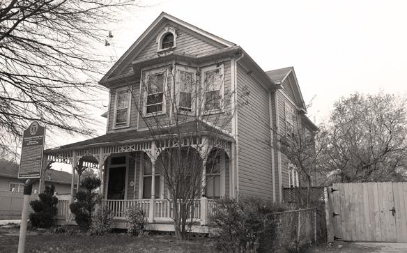
Samuel Hargrove House
5907 K Street Historic Site 72-009-17
Site of William Sidney Pittman House
505 Eastern Avenue Historic Site 72-009-18

Samuel Hargrove House James F. Armstrong House
5907 K Street 908 59th Avenue Historic Site 72-009-17 Historic Site 72-009-24
Samuel Hargrove House Towles-Brooks House
5907 K Street 708 59th Avenue Historic Site 72-009-17 Historic Site 72-009-27
Samuel Hargrove House Isaac Brown House
5907 K Street 715 59th Place Historic Site 72-009-17 Historic Site 72-009-30


John S. Johnson House 612 60th Place Historic Site 72-009-32

Trammell-Taylor House 717 59th Avenue Historic Resource 72-009-26
Henry Pinckney House
608 60th Place Historic Resource 72-009-33
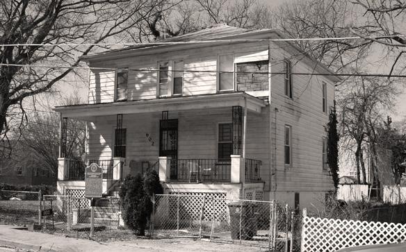
Cornelius Fonville House
602 60th Place Historic Site 72-009-35
Louis Brown House 701 58th Avenue Historic Resource 72-009-28

Doswell Brooks House
6107 Foote Street Historic Resource 72-009-36
Robert S. Nichols House
910 59th Avenue Historic Site 72-009-39

William B. Coles House 730 60th Avenue Historic Resource 72-009-31

Prince Albert Washington House 949 Eastern Avenue Historic Resource 72-009-43
6 THE HOUSES OF FAIRMOUNT HEIGHTS: A PATTERN BOOK | Prince George’s County Planning Department
