Transpo r tation Review Guidelines
Part 1 and Part 2
2022 Supplement
Revised September 2022
Abstract
Date May 2022
Revised September 2022
Title Transportation Review Guidelines Part 1 and Part 2 2022 Update
Author The Maryland-National Capital Park and Planning Commission
Subject The technical standards for the evaluation of the adequacy of transportation facilities, along with other plan evaluations, by the Prince George’s County Planning Board and the staff of the Transportation Planning Section
Source of copies The Maryland-National Capital Park and Planning Commission 14741 Governor Oden Bowie Drive Upper Marlboro, MD 20772
Series number 976222405
Number of pages 79
The primary purpose of the Transportation Review Guidelines Part 1 and Part 2 2022 Supplement (Supplement) is to provide the technical standards for evaluating the adequacy of transportation facilities by the Prince George’s County Planning Board a ccording to the Zoning Ordinance and Subdivision Regulations effective April 2022. It also documents processes and procedures to review development plans and area master plans. The Supplement establishes criteria by which staff and applicants with land development proposals can assess the transportation impacts related to development proposals. They also indicate how information will be presented to the Planning Board.
This document is divided into two parts. Part 1 is further organized in 10 sections. Section 1 describes the process of gathering existing data and submitting studies; it also includes a glossary of transportation terms. Section 2 summarizes study requirements for the various types of applications. Section 3 details the methodology to be used in performing the traffic study. Sections 4–6 describe the use of a system of trip credits related to design as well as off-site transit, pedestrian, and bicycle facilities. Section 7 documents transportation modeling procedures and a tier system to guide developers for implementing mitigation strategies and actions. Section 8 includes the County Council’s guidelines for mitigation actions when mitigation action does not result meeting LOS standards. Sec tion 9 specifies several processes for reviewing plans that are not traffic impact studies. Section 10 denotes the implementation and applicability of the updated guidelines. Part 2 guides the determination of adequacy of bicycle and pedestrian facilities
Page
Transportation Review Guidelines
2of79: 2022
Page 3of79: 2022 Transportation Review Guidelines May 2022 Revised September 2022 Prepared by Kittelson & Associates, Inc. for The Maryland-National Capital Park and Planning Commission Prince George’s County Planning Department 14741 Governor Oden Bowie Drive Upper Marlboro, MD 20772 www.pgplanning.org
Page 4of79: 2022 Transportation Review Guidelines Contents Introduction 6 A. Applicability of Prior Zoning Ordinance and Subdivision Regulations ............................................. 7 Part 1: Transportation Review Guidelines .................................................................................................. 9 Section 1: General Requirements 10 A. Glossary of Transportation Planning Terminology ........................................................................ 10 B. Traffic Impact Study Scoping ......................................................................................................... 19 C. Traffic Information Submittal, Acceptance, and Review ............................................................... 24 D. Inventory of Existing Conditions for Traffic Impact Studies .......................................................... 25 E. Access 28 F. Policy Standards ............................................................................................................................ 29 Section 2: Requirements/Findings for Various Application Types 31 A. Preliminary Plans of Subdivision ................................................................................................... 31 B. Certificate of Adequacy Requirements ......................................................................................... 33 C. Special Requirements.................................................................................................................... 34 Section 3: Traffic Impact Study 38 A. Updated LOS and Critical Volume Lane Standards ........................................................................ 38 B. Updated Trip Generation Tables ................................................................................................... 39 C. Updated Mitigation Threshold Requirements ............................................................................... 41 Section 4: Transit-Oriented Development in Centers ............................................................................... 43 Section 5: Transit Facilities 44 Section 6: Bicycle and Pedestrian Facilities ............................................................................................... 45 Section 7: Transportation Network Analysis ............................................................................................. 48 Section 8: Guidelines for Mitigation Actions 51 Section 9: Other Transportation Planning Topics 55 Section 10: Effective Date of Application 56 A. Traffic Studies and Scopes ............................................................................................................ 56 B. Other Transportation Reviews 56 C. Determinations of Compliance with Conditions 56 Part 2: Evaluating Bike and Pedestrian Analysis 58 Section 1: Background .............................................................................................................................. 59 Section 2: Bicycle and Pedestrian Analysis................................................................................................ 60 A. Applicable Areas for Bicycle and Pedestrian Analysis 60 B. Bicycle and Pedestrian Analysis 60 Section 3: Complete Streets ...................................................................................................................... 71 Section 4: Provisions and Clauses of Section 24-4506 .............................................................................. 72 A. Purpose ......................................................................................................................................... 72 B. Applicability .................................................................................................................................. 72 C. Adequacy Standards for Pedestrian and Bicycle Facilities............................................................. 72 D. Availability..................................................................................................................................... 74
List of Tables and Figures
Page 5of79: 2022 Transportation Review Guidelines APPENDIX A: References and Sources of Additional Information ............................................................. 75 APPENDIX B: Map of Transportation Service Areas 77 APPENDIX C: New Ordinance Case Type Nomenclature For Dams ........................................................... 78
Tables: Table 1: TIS Scoping Agreement 21 Table 2: List of Attachments for TIS Scoping Agreement 24 Table 3: Policy Level of Service Standards 30 Table 4: Summary of Traffic Study Requirements by Case Type 32 Table 5: Development Requirements Prior to Expiration of Period of Validity for Approved Certificate Based on Table 24-4503(c)................................................................................................................ 34 Table 6: Critical Lane Volume and LOS Standards 38 Table 7: Residential Trip Generation 39 Table 8: Employment Trip Generation ...................................................................................................... 40 Table 9: Retail and Institutional Trip Generation ...................................................................................... 41 Table 10: Bicycle or Pedestrian Facility Trip Credits .................................................................................. 46 Table 11: Mitigation Standards as Set in Section 24-4505 ........................................................................ 51 Table 12: Bicycle and Pedestrian Impact Statement (BPIS) Scoping Agreement ....................................... 62 Figures: Figure 1: Required Steps in the Bicycle and Pedestrian Analysis for Subdivisions .................................... 61
Introduction
The Prince George’s County Planning Board initially adopted general criteria and guidelines for the analytical review of the traffic impacts of land development proposals on March 3, 1977. These criteria and guidelines were revised in 1980, 1984, 1989, 1997, 2002, 2012, and 2013. Transportation Review Guidelines Part 1 and Part 2 2022 Supplement (Supplement) modifies the 2012 and 2013 Transportation Review Guidelines and guides development applications proceeding under the new Zoning Ordinance and Subdivision Regulations that took effect April 1, 2022 Furthermore, the Supplement incorporates principles and policies set in the 2014 Plan Prince George’s 2035 Approved General Plan (Plan 2035)
Guidelines for transportation review, public safety facilities, parks and recreation adequacy, and environmental review were developed by technical staff and approved by the Planning Board to provide clear procedures and standard metrics that guide how applications are analyzed. Procedures and metrics were also developed to guide determinations of whether facilities necessary for proposed developments are in fact adequate to mitigate the impacts of development and achieve standards specified by the Subdivision Regulations.
For these guidelines, including this Supplement, national best practices were reviewed and calibrated to the unique local conditions and requirements of Prince George’s County. The resulting guidelines provide clarity and transparency and are designed to impose uniform standards applicable to every application. These standards ensure each decision is made fairly and equitably and eliminates the potential for arbitrary and capricious decision-making. The guidelines are divided into two parts. The first part modifies the 2012 Transportation Review Guidelines; the second part modifies the 2013 Transportation Review Guidelines’ standards for evaluating the adequacy of bicycle and pedestrian facilities.
For Part 1, the highlights of each section are
Section 1: This section includes a glossary of transportation terms. It also describes the process of scoping and submitting a study, the process of gathering existing data within the study area, issues regarding access, and the policy standards for facility evaluation. A revised Scoping Agreement and a requirement that all traffic information be submitted in an electronic format are in this section.
Section 2: This section describes the findings and studies required for each type of development application. The final subsection of this section includes several special circumstances.
Section 3: Refer to 2012 Transportation Review Guidelines , Part 1. Exceptions are noted at the beginning of this section.
Section 4: Refer to 2012 Transportation Review Guidelines , Part 1. Exceptions are noted at the beginning of this section.
Sections 5 & 6: Refer to 2012 Transportation Review Guidelines, Part 1. Exceptions are noted at the beginning of this section.
Page 6of79
: 2022 Transportation Review Guidelines
Section 7: Refer to 2012 Transportation Review Guidelines , Part 1. Exceptions are noted at the beginning of this section. This section has been updated to including a tiered system for offsetting traffic impacts to an acceptable level of service (LOS)
Section 8: This section is composed of the Guidelines for Mitigation Actions, as approved by the new Zoning Ordinance and Subdivision Regulations. It describes the process of analyzing mitigation and is virtually unchanged from the previous guidelines (except where noted). This section also discusses mitigation strategies that an applicant may request to apply if the applicant exceeds the LOS standards by a certain percentage.
Section 9: Refer to 2012 Transportation Review Guidelines, Part 1. Exceptions are noted at the beginning of this section. This section includes four topics generally outside the scope of preparing and reviewing traffic impact studies: (1) analysis procedures for developments generating fewer than 50 trips, (2) best practices for subdivision and site layout, (3) right-of-way procedures, and (4) procedures for the review of departures and variations. These topics were included to standardize review processes within the Transportation Planning Section.
Section 10: This section briefly discusses the timing for implementing the updated guidelines after adoption and presents provisions for circumstances in which the 2012 guidelines may be used after these updated guidelines are adopted.
A. Applicability of Prior Zoning Ordinance and Subdivision Regulations
The new Zoning Ordinance and Subdivision Regulations, initially approved October 2018 and amended November 2021, went into effect April 1, 2022. This Supplement will apply to all development applications requiring approval of a Certificate of Adequacy under the new laws.
The provisions in this document modify the 2012 and 2013 Transportation Review Guidelines. However, some sections of the prior guidelines remain applicable, and the Supplement will refer applicants to the 2012 and 2013 Guidelines whenever applicable. When sections from prior guidelines are referenced, applicants must note the following changes:
• References to Tiers have been replaced with Transportation Service Areas, in accordance with Plan 2035:
o The Developed Tier has been replaced by Transportation Service Area 1 (TSA 1) All centers are now equivalent to TSA 1 except for Local Transit-Oriented (LTO) and Regional Transit-Oriented (RTO) core and edge areas, which have more relaxed critical lane volume (CLV) standards
o The Developing Tier has been replaced by Transportation Service Area 2 (TSA 2)
o The Rural Tier has been replaced by Transportation Service Area 3 (TSA 3)
o Corridors were removed as a General Plan policy area by Plan 2035.
• The 2022 Zoning Ordinance and Subdivision Regulations section numbers vary from the prior codes. The section references are updated here where applicable; when referring to the prior codes (the prior Zoning Ordinance or prior Subdivision Regulations), section numbers will not correspond to the new codes
Page 7of79: 2022 Transportation Review Guidelines
• References to the General Plan or the 2002 Prince George’s County Approved General Plan (2002 General Plan) are updated to the 2014 Plan Prince George’s 2035 Approved General Plan (Plan 2035)
• The 2022 Zoning Ordinance consolidates many zoning categories. To view differences between the new and old zoning, please visit Current and Proposed Zones on the County’s website (pgplanning.com).
The new Zoning Ordinance and Subdivision Regulations establish new transit-oriented and activitycenter base zones with updated public facility adequacy standards that promote multimodal access to, from, and within developments, designated centers, and the County’s Innovation Corridor This Supplement reflects these new standards that incentivize developments to reduce vehicle trips and to improve transit, bicycle, and pedestrian facilities.
8of79: 2022 Transportation Review Guidelines
Page
Part 1: Transportation Review Guidelines
Page
2022 Transportation Review Guidelines
9of79:
Section 1: General Requirements
All studies should use the same general approach for analyzing traffic impacts. Although the required findings for various types of applications differ and the standards may change between the different transportation study areas (TSAs), the process for conducting the analysis should remain consistent. This section provides common terminology and a common approach for data collection, traffic impact study (TIS) scoping, and information submittal. It also summarizes the overall policy standards for transportation analysis in Prince George's County.
A. Glossary of Transportation Planning Terminology
The following glossary includes transportation-specific terms used throughout this document. It also includes abbreviations used in this Supplement and provides either the full term or a reference to another term in the glossary. Many terms are formally defined in Subtitle 24 (Subdivision Regulations) or Subtitle 27 (Zoning Ordinance) of the Prince George’s County Code Those terms are not repeated or paraphrased here; instead, refer to the Definitions section of each subtitle.
Glossary Term Definition
Access Controls
Adequate Public Facilities
ADT
All-Way Stop Control
APF
Arterial
At-Grade Intersection
Average Daily Traffic (ADT)
Regulations by which access to a road facility from individual driveways, minor streets, or major streets may be limited for the purpose of increasing roadway capacity and improving safety.
A type of local regulation intended to address the impacts of growth by requiring completion of infrastructure prior to, or at the same time as, new development that will impact that infrastructure
See Average Daily Traffic.
See Unsignalized Intersection.
See Adequate Public Facilities
A highway for through and local traffic, either divided or undivided, with controlled access to abutting properties and at-grade intersections.
The location at which two or more roadways cross and join at the same elevation; access through the intersection may be controlled by traffic signals or stop/yield signs.
The total traffic volume passing a point along a roadway in both directions during an average 24-hour period.
Page 10of79
2022 Transportation Review Guidelines
:
Glossary Term Definition
Background Development
Background Traffic
Bicycle and Pedestrian Impact Statement (BPIS)
For purposes of subdivision review; approved and unbuilt development within the study area having any one of the following: an approved and valid preliminary plan of subdivision; a valid final plat; a record plat not required to be re-subdivided pursuant to Section 24-3400; an approved special exception; or a capital project involving new or expanded facilities that has full construction funding within six years in an approved capital program of a governmental entity.
In a TIS, includes (1) existing traffic, (2) traffic generated by background development, (3) growth in through traffic on the current road network, and (4) all roadway improvements that are fully funded by the State, County, or another party
Analysis that evaluates the adequacy of pedestrian and bicycle facilities and must be submitted as part of the Certificate of Adequacy.
Capacity On a roadway link, the maximum number of vehicles that can pass a given point during a defined period under prevailing roadway and traffic conditions. This is often described as the upper limit of LOS E.
Capital Improvement Program (CIP)
Center
CIP
CLV
Collector
A six-year comprehensive statement of the objectives of capital programs with cost estimates and proposed construction schedules for specific projects; tool through which locally-funded public facilities such as sewers, local roads, schools, libraries, and parks can be scheduled and built; unless otherwise stated, CIP refers to the Prince George’s County CIP.
A geographic policy area designation in Plan Prince George’s 2035 Approved General Plan (and any subsequent approved amendments to this plan, which may be amended from time to time), generally proximal to current or future transit stations including Purple Line light rail transit stations. Centers are classified as either a Regional Transit District or a Local Center. See also TSA , Local Center, and Regional Transit District.
See Capital Improvement Program.
See Critical Lane Volume.
A two- to four-lane roadway with minimal access controls that provides movement between developed areas and the arterial system.
11of79: 2022 Transportation Review Guidelines
Page
Glossary Term Definition
Consolidated Transportation Program (CTP)
Critical Lane Volume (CLV)
Critical Intersection
Critical Link
Critical Roadway
Critical Movement
CTP
De Minimis Development
Design Speed
Diverted Trip
DPW&T
DRD
Existing Traffic
A six-year comprehensive statement of the objectives of capital programs with cost estimates and proposed construction schedules for specific projects. The Maryland State CTP is prepared by the governor and adopted by the state legislature. The CTP is the tool through which State-funded public facilities can be scheduled and built.
The sum of critical movements at an intersection. For a four-way intersection, this would be the sum of the critical movements in the north-south direction and the east- west direction
In general, any intersection serving 20 percent or 150 peak-hour trips (whichever is less) of the applicant's site -generated traffic. Refer to Section 1, Subsection B for precise criteria in determination.
In general, any roadway segment serving 20 percent or 150 peakhour trips (whichever is less) of the applicant's site-generated traffic. Refer to Section 1, Subsection B for precise criteria in determination.
See Critical Link.
At a four-way intersection, the highest total of a through movement plus its opposing left-turn movement in one direction on an hourly, per-lane basis. For example, the critical movement in the northsouth direction of an intersection is the highe r of (1) the northbound through movement plus the southbound left-turn movement, computed on an hourly per-lane basis; and (2) the southbound through movement plus the northbound left-turn movement, computed on an hourly per-lane basis.
See Consolidated Transportation Program.
A development which generates five or fewer peak-hour trips.
The maximum safe speed for which the various physical features of a roadway are designed.
A trip deviated to a site from an adjacent roadway without direct access to the site.
The Prince George’s County Department of Public Works and Transportation.
The Development Review Division in the Prince George’s County Planning Department.
In a TIS, current traffic in accordance with recent traffic counts on the current road network.
Page 12of79: 2022 Transportation Review Guidelines
Glossary Term Definition
Expressway
Fixed Guideway Transit (FGT)
Four-Way Stop Control
Freeway
A divided highway for through traffic with full or partial access controls and grade-separated interchanges at selected public roadways; has some at-grade intersections.
A public transportation system of vehicles that operate primarily on their own pathway or right-of-way constructed for that purpose. The term is inclusive of rail transit (including light rail, commuter rail, and Metrorail) and bus rapid transit
See Unsignalized Intersection.
A divided highway for through traffic with full access controls and grade-separated interchanges at selected public roadways.
General Plan (Plan 2035) The County’s Plan Prince George’s 2035 Approved General Plan, also referred to as Plan 2035 This term includes any successor documents as well as any approved amendments.
Grade-Separated Interchange
Grade Separation
Interchange
Internal Trip Capture
Intersection
Level of Service (LOS)
Link
Local Center
LOS
A location where multiple roadways cross; one roadway passes over the other on an overpass; a system of ramps joins the roadways.
A location where two roadways cross; one passes over the other on an overpass, but the roadways lack a direct connection via a system of ramps.
See Grade-Separated Interchange.
A reduced trip generation number that accounts for the “capture” of vehicles that will travel from one land use to another within a mixed-use development without leaving the site and by using the roadway system beyond the development.
See At-Grade Intersection.
A qualitative measure that uses a sequence of letters from A through F to describe the quality of operational conditions within an intersection or a roadway link. The LOS standards used in the guidelines are based on the 2022 Zoning Ordinance and Subdivision Regulations, Plan 2035, and any successor documents.
See Roadway Link.
Plan 2035 designates 26 Local Centers, which include new Purple Line stations, as focal points for development and civic activity based on their access to transit or major highways. See also Regional Transit District.
See Level of Service.
LTO Local Transit-Oriented Zone
Page
13of79: 2022 Transportation Review Guidelines
Glossary Term Definition
Major Collector
Mitigation
Modal Split
Operating Speed
Other Master Plan Roadway Facilities
Pass-By Trip
Peak Hour
Peak Hour Factor (PHF)
Peak Period
A four-lane divided roadway with controlled access to abutting properties and at-grade intersections.
In Prince George’s County, a specific process for achieving adequate transportation facilities in accordance with Section 24-4505; described in greater detail in Section 8.
The percentage of people using a particular means of transport (such as a vehicle, transit, or walking) to make a trip.
The maximum average observed speed for a given set of roadway and traffic conditions.
Residential, industrial, and commercial roadways that provide access to and between developed areas and are shown selectively on area master plans.
A trip made to a site (generally a commercial site) from traffic already "passing by" that site on an adjacent street with direct access to the generator.
The one-hour period of greatest use of a transportation facility or the greatest trip generation of a use. Weekdays normally have two peak hours: one in the morning and one in the afternoon Saturdays and Sundays are typically represented by a single peak hour.
The ratio of the hourly traffic flow rate to the peak rate of traffic flow within the hour. This factor is most often used in traffic studies to analyze unsignalized intersections. When the analysis period is 15 minutes, the ratio is computed as the peak-hour traffic volume (VPH) divided by the peak 15-minute traffic volume (V15) times four; in equation form, PHF = VPH / (V15 × 4).
A three-hour period during which a transportation facility has significantly increased levels of use; this period includes the peak hour. Weekdays normally have two peak periods : one in the morning and one in the afternoon.
PD Planned Development
PFFIP See Public Facilities Financing and Implementation Program.
PGTAZ See Traffic Analysis Zone.
Pro Rata Share
The portion of the cost of a transportation facility attributable to a development based upon its traffic impact on the facility.
Page 14of79: 2022 Transportation Review Guidelines
Glossary Term Definition
Public Facilities Financing and Implementation Program (PFFIP)
Queuing Study
Ramp
A financing strategy to create specific facilities that serve one or more developments within a specific area, as defined in Section 242300 of the Subdivision Regulations . The program must be established by the County Council with the specific financing strategy prior to its usage in the development approval process.
An analysis that estimates the length of a line of waiting vehicles; typically done to ensure turn bays and other intersection approaches are of adequate size and length.
A length of roadway that provides an exclusive connection between two highway facilities, usually within a grade- separated interchange.
Regional Transit District Plan 2035 designates eight priority development areas that have extensive transit and transportation infrastructure and the longterm capacity to become mixed-use, economic generators for the County as Regional Transit Districts. These Regional Transit Districts were selected based on a quantitative analysis of 31 indicators that assessed the capacity and potential of each area to support future growth and development. See also Local Center and TSA.
RTO
Roadway Link
Roundabout Intersection
Scoping Agreement
Screenline
Regional Transit-Oriented Zone
A segment of roadway between two points.
A type of unsignalized intersection that is a modern form of a traffic circle or rotary. Its approaches yield to traffic in the circle, and its channelized entry points maintain lower speeds within the circle.
A signed statement that specifies the study area and other major assumptions associated with the preparation of a traffic impact study.
An analysis line that bisects a study area used for transportation demand model validation. Generally, screenlines follow natural or constructed geographic features.
SCRP See Surplus Capacity Reimbursement Procedure.
Service Volume
On a roadway link, the maximum number of vehicles that can pass a given point at a given level of service hourly.
SHA The Maryland State Highway Administration of the Maryland Department of Transportation.
Sight Distance Study
An analysis of the length of roadway visible to a driver; normally done to assess safety issues associated with an intersection or an access point.
Page 15of79: 2022 Transportation Review Guidelines
Glossary Term Definition
Signalized Intersection
Spillback
Study Timeframe
Subdivision and Development Review Committee
A location at which two roadways cross and join at the same vertical elevation and where access through the intersection is controlled by a traffic signal or traffic light.
Occurs when a queue from a downstream signalized intersection occupies the entire link and prevents vehicles from entering an upstream signalized intersection on a green light
The period over which future traffic is to be estimated by a traffic study. Most studies will estimate traffic conditions over a three- to six-year period.
A staff committee composed of various reviewers from the Prince George’s County Planning Department and other County and State agencies; this committee meets every two weeks to coordinate interagency review of development cases. The committee is defined by Section 24-2300 of the Subdivision Regulations and assists the planning director in coordinating review of all preliminary plans of subdivision, detailed site plans, and sketch plans
Surplus Capacity Reimbursement Procedure (SCRP)
Technical Staff Report
Through Traffic
TIS
Total Traffic
TPS
A process that allows a development to provide a needed transportation improvement up front and be reimbursed for the cost of providing the improvement on a pro rata basis by subsequent developments. Council Bill CB-60-1993 and all subsequent amending bills provide specific requirements for the use of the SCRP.
A document prepared by the Planning Department’s Development Review Division (DRD) staff in advance of a public hearing that reviews a development proposal. The review recommends approval, approval with conditions, or denial; provides supporting background information about the proposal; and presents all required findings in support of the recommendation. The report is submitted to the Planning Board and other decision-making bodies for consideration during the hearing.
Trips that pass through a study area but begin and end outside of it.
See Traffic Impact Study.
In a TIS, background traffic plus traffic generated by the development under consideration.
The Transportation Planning Section of the Countywide Planning Division in the Prince George’s County Planning Department.
16of79: 2022 Transportation Review Guidelines
Page
Glossary Term Definition
Traffic Analysis Zone (TAZ)
Traffic Control Device
Traffic Impact Study (TIS)
A geographically distinct area defined by natural or constructed features. Socioeconomic and demographic data for each zone are analyzed to help estimate future transportation demand. Within the county, this geography is often called the Prince George’s traffic analysis zone (PGTAZ).
Any sign, signal, pavement marking, or device placed or erected for the purpose of regulating, warning, or directing traffic and/or pedestrians and bicyclists
Assesses the effects that a particular development will have on a community’s transportation network beyond the boundaries of that development. Studies typically include an assessment of the existing situation, the future situation without the development, and the future situation with the development. These three scenarios are called the existing, background, and total traffic situations, respectively.
Traffic Signal Phasing
Traffic Signal Warrant Study
TransForM
Transportation Demand Forecasting Model (TDFM)
Transportation Demand Management (TDM)
Transportation Demand Management District
How a traffic signal cycle (the time required for one complete sequence of signal indications) is allocated for a traffic movement or combination of traffic movements.
An analysis done to review the criteria required to install a traffic signal at an intersection. The Federal Highway Administration has identified 11 circumstances under which a signal may be justified. The warrants include measures of volume, safety, delay, and general operations.
The long-term travel forecasting computer model employed and maintained by TPS staff (the term is a shortened form of “Transportation Forecasting Model”).
A collection of data files and computer programs that forecast highway traffic volumes, transit ridership, and other aspects of future usage and performance of a transportation system.
A strategy intended to reduce vehicle trips during specified periods of the day. This includes but is not limited to car and van pools, transit use incentives, parking fees and disincentives, and improved pedestrian and bicycle access and facilities.
A legally defined geographic area, established by the Prince George’s County Council pursuant to Subtitle 20A, in which vehicle trip reduction procedures, strategies, and programs are required.
Page
17of79: 2022 Transportation Review Guidelines
Glossary Term Definition
Transportation Facilities Mitigation Plan (TFMP)
Transportation Service Area (TSA)
Trip
Trip Assignment
Trip Cap
Trip Credit
Trip Distribution
Trip Generation
A document or a section in a traffic impact study that proposes mitigation actions pursuant to Section 24-4500(a)(6) of the County Code. The TFMP shall indicate at least one geographic criterion that makes a site eligible for mitigation, describe the recommended mitigation action; show the analyses that indicate that the mitigation action meets the numerical criteria for consideration; and provide justification for the use of mitigation as opposed to meeting conventional adequacy standards.
A geographic policy area designation in Plan 2035 (as may be amended). County areas are designated as being within Transportation Service Area 1, Transportation Service Area 2, or Transportation Service Area 3. See also Center.
A one-way movement with an origin and destination made by a person or a vehicle.
The process of allocating vehicle travel generated within a land parcel to each link of the roadway network.
A limit on the off-site traffic impact of a development proposal. This type of limit is typically enforced through a condition placed on a development by the Planning Board. Such a condition is based on (1) the quantities and types of uses specified in the TIS and (2) the trips generated by these uses after the application of any discounts, adjustments, or credits.
Reduced trip generation for a site approved pursuant to the provision of transit-oriented design (TOD) elements, transit facilities, or bicycle and pedestrian facilities in accordance with the procedures in Sections 4, 5, and 6.
The process of estimating the direction of travel and the length of vehicle trips originating from or destined for the uses on a land parcel.
The process of estimating the number of vehicle trips originating from or destined for the uses on a land parcel.
TSA See Transportation Service Area.
Two-Way Stop Control See Unsignalized Intersection.
Page 18of79: 2022 Transportation Review Guidelines
Glossary Term Definition
Unsignalized Intersection A location at which two roadways cross and join at the same elevation, with access through the intersection controlled by stop or yield signs. Two-way stop control requires that each approach on the more minor roadway encounters a stop sign before proceeding through the intersection. Four-way (or all-way) stop control requires that each approach encounters a stop sign before proceeding through the intersection. See also Roundabout Intersection.
Volume-to-Capacity Ratio (v/c) A performance measure computed using the ratio of an actual or future estimated roadway volume to the capacity of a roadway link.
B. Traffic Impact Study Scoping
As part of the ongoing update to the Transportation Review Guidelines (TRG), the Prince George’s County Planning Department will modify the scoping process for traffic impact studies (TISs) for development review applications. The intent of the scoping process is to coordinate centralized scoping meetings with the applicant and all agencies involved in the review of traffic impact studies.
The following are procedural requirements for scoping meetings:
The applicant shall submit a transportation pre-submittal checklist to the Planning Department for a determination of a TIS or other transportation assessment for a development proposal. The checklist shall be completed in advance of a scoping meeting.
If a TIS is required, the applicant shall submit a scoping agreement form to the Transportation Planning Supervisor with a request for a scoping meeting at least two weeks after the day of submittal.
The Planning Department will coordinate with operating agencies to determine a date and time for the scoping meeting.
o The Planning Department will send an invitation to the meeting via email; the invitation will verify the date of the scoping meeting and include the draft scoping form
The scoping of a TIS should be developed based on the requirements of transportation adequacy as outlined in the subdivision or zoning ordinance.
If approved by the Planning Department at the time of scoping, additional supplemental analysis may be incorporated to assist in other approvals (permitting) or for understanding mitigation, proposed improvements, or additional consideration.
o The scoping and TIS may note that recommended analysis for future approvals can be considered later.
Given that TISs are required for adequacy of subdivision and zoning cases, the Planning Department has final approval of which elements are included in the scope.
Scoping meetings should be conducted as follows :
The Planning Department will coordinate with the Department of Permitting, Inspections and Enforcement (DPIE), the Department of Public Works and Transportation (DPW&T), and the
Page 19of79: 2022 Transportation Review Guidelines
Maryland State Highway Administration (SHA) to establish set days and time blocks for scoping meetings
o Days are to be determined by the Transportation Planning Section (TPS).
o Staff will only meet when a formal request has been made and accepted
o Scoping meetings shall take no more than 30 minutes per scope unless additional time is allocated by Planning Department staff for BPIS scope and/or complex cases
A list of attendees will be documented for each scoping meeting
The applicant shall present the draft scoping form in its entirety and provide visual exhibits as outlined on the scoping form
The applicant will submit a revised scoping form to address staff comments within seven days of the scoping meeting.
The Planning Department will provide an approved scoping form and signature within seven days of receiving the revised scoping form from the applicant.
An assessment of the area affected by traffic generated by the proposed development is mandatory. The study area size and shape will depend on the size and type of development proposed, the existing and planned roadway system, adjacent and proposed land uses, and the presence of natural or constructed barriers. Prior to beginning a TIS, the applicant or applicant’s designee shall submit a Scoping Agreement, shown in Table 1, and request concurrence of TPS staff.
The Scoping Agreement specifies the study area and other relevant assumptions associated with the TIS. The study area should generally include all significant transportation facilities to which 20 percent or 150 peak-hour trips (whichever is less) of the application's site-generated traffic is assigned. Subject to the above criteria, the following facilities shall be included in the study as critical for review of the application:
• Any site access point intersection
• All at-grade intersections between collector, arterial, and/or expressway facilities
• Interchange ramp at-grade intersections with lesser facilities
• Primary street, secondary street, or driveway intersections with higher facilities that involve significant turning movements
• Critical roadway links connecting the site to any critical intersection, as described by the following:
A link that includes an approach to an intersection that does not meet the level of service (LOS) standard without funded improvements or otherwise provided by the applicant should be deemed critical, subject to the following limitations , which are described more fully under “Links” in Subsection 3(A):
• Any link for which queuing does not result in spillback to the adjacent upstream signalized intersection shall not be studied.
• Any link that is constructed to its master plan recommended crosssection shall not be studied.
• Any link shorter than 400 feet in length shall not be studied.
Roundabout intersections within Interstate Highway System interchanges (along I-95, I-295, I-495, or US 50) are specifically excluded from the study area.
Page
20of79: 2022 Transportation Review Guidelines
A scoping agreement is not needed when it has been determined that a TIS is not needed to support an application.
Table 1: TIS Scoping Agreement
The Maryland-National Capital Park and Planning Commission
Prince George’s County Planning Department
Transportation Planning Section, Countywide Planning Division
This form must be completed prior to commencing a traffic impact study (TIS). The completed and signed scoping agreement should be submitted to the Transportation Planning Section (TPS) by the traffic consultant for concurrence and signature. TPS will return a signed copy, with any comments, to the traffic consultant for inclusion in the TIS. Failure to conduct the study in accordance with the guidelines and the signed scoping agreement may be grounds for rejection of the study and thereby necessitate an addendum or a new study prior to the start of the staff review.
Project Name:
Transportation Service Area (TSA): Please note if in Local Center or Regional Transit District (Map of TSAs in Appendix)
Zoning Classification per the new Ordinance and, if this application is submitted under the prior Ordinance, Zoning Classification under the prior Ordinance:
Proposed Zoning Classification (if rezoning was requested as part of application)
Type of Application (see Table 4):
Project Location:
Traffic Consultant Name:
Contact Number(s):
Email Address(es):
Describe the Proposal Under Study:
Residential Number and Type of Units: Commercial Amount and Type of Space: Other Uses and Quantity:
Page
21of79: 2022 Transportation Review Guidelines
Are pass-by trip rates in accordance with the Transportation Review Guidelines ? (select one)
Are there diverted trips? (select one) Yes
Will a transit-oriented development (TOD) credit be used? (Section 4 of the Transportation Review Guidelines) (select one)
Will a transit facilities credit be used? (Section 5 of the Transportation Review Guidelines) (select one)
Will a bike/ped facilities credit be used? (Section 6 of the Transportation Review Guidelines) (select one)
Are additional trip reductions (internal trips, transit trips, etc.) proposed? (select one) Yes
If no, please provide explanation on separate sheet.
If yes, please provide explanation on separate sheet.
Note that all development in TSAs and Regional Transit Districts Centers will be evaluated for TOD.
Need/nexus must be justified in study and supported by operating agency
Need/nexus must be justified in study and supported by operating agency
If yes, please provide explanation on separate sheet.
Attach one or more maps showing the study area network including intersections and links, estimated site trip distribution, and growth factors for through traffic.
Maryland State Highway Administration (SHA) and Department of Public Works and Transportation (DPW&T) capital program improvements assumed:
Other improvements assumed:
Regional growth assumed:
Is mitigation (Section 8 of the Transportation Review Guidelines) to be proffered? (select one) Yes
Note the locational criteria in Section 8, and please note the clarifications regarding mitigation included in Section 3, Subsection E.
Page
2022
22of79:
Transportation Review Guidelines
Yes No
No
No
Yes
Yes No
No
Yes
No
No
Is a cooperative funding arrangement such as a Surplus Capacity Reimbursement Procedure (SCRP), Public Facilities Financing and Implementation Program (PFFIP), or some other pro rata to be used? (select one)
Will summer counts be used? (select one)
Have there been discussions with the permitting agency (SHA and/or DPW&T) regarding access to this site and the analysis requirements? (select one)
Yes
Has a listing of background development been developed? (select one)
Yes
If yes, please provide explanation on separate sheet, and note limitations in Section 3, Subsection E.
The use of summer counts must have specific concurrence of TPS staff.
Section 1, Subsection E strongly advises that these discussions occur early in the development review process. Note that driveway access onto arterial facilities must be justified and approved by the Planning Board as a part of the subdivision process.
If yes, please provide the list so that TPS staff may either concur or provide changes.
Has a list of attachments been completed and attached (Table 2)?
SIGNED: Traffic Consultant
APPROVED:
TPS Coordinator (or Supervisor)
This form is not required for sites that do not require a TIS.
Date
Date
Page 23of79: 2022 Transportation Review Guidelines
No
Yes No
No
Yes No
Yes No
Table 2: List of Attachments for TIS Scoping Agreement
No. Attachment Description
1. List of meeting attendees at scoping meeting:
2. Aerial (map of project site):
3. List and map of critical intersections:
4. Map of site access (conceptual site plan):
5. Diagram and memo of trip distribution:
6. List and map of trip credits and locations:
7. List and map of background developments in study area:
C. Traffic Information Submittal, Acceptance, and Review
Traffic Studies: The primary means of submitting a TIS shall be an electronic file in PDF format Submission should be consistent with all Development Review Division (DRD) policies and requirements. The PDF must be received before acceptance review of a study can commence. All submittals of a TIS or other traffic data for the record must be made via email to DRD at DRDApplications@ppd.mncppc.org. Every TIS received by DRD staff is immediately logged and forwarded to TPS staff.
Once a TIS is received by TPS staff, a review of the study for sufficiency will be completed within three working days. This review consists of the following:
1. Confirming that the study conforms to the plan being submitted.
2. Verifying existing conditions.
3. Checking consistency of all assumptions in the submitted study with the scoping agreement and other supporting documentation of the application.
4. Confirming the appropriate use of procedures and methods of analysis from these guidelines or from other professionally recognized sources.
5. Confirming the inclusion of all count sheets, surveys, other site-specific field data, and the Scoping Agreement.
Page
24of79: 2022 Transportation Review Guidelines
Yes No N/A
Studies deemed insufficient may not be referred, and TPS staff will contact the applicant and the applicant's traffic consultant to indicate deficiencies. Traffic studies shall not be accepted for review unless the accompanying development application has also been accepted and referred.
Once the TIS is deemed acceptable, it is electronically referred to other agencies for review and comment. Consistent with the submittal requirements, it is anticipated that most studies will be referred as single or multiple email attachments ; very large studies may be referred by means of downloading through an FTP site. Traffic studies in support of a subdivision application must be accepted for review at least 55 calendar days prior to the scheduled Planning Board hearing date. Traffic studies in support of urban design or zoning cases must be accepted for review at least 65 days prior to the scheduled Planning Board hearing or review date. These review timelines allow 30 days for agency review; four days for TPS staff to review agency comments and coordinate preparation of a recommendation; and 21 days (28 days for urban design and zoning cases) for DRD staff to coordinate comments, prepare the technical staff report, and publish it in a timely manner as required by the County Code. Revisions to studies, especially studies involving mitigation or requiring SHA review, can require a new 30-day period for agency review and may result in a delay in the Planning Board hearing date.
Other Traffic Data: The primary means of submittal of requested traffic data (such as turning movement counts, trip generation data, or other information) shall be an electronic PDF file. All traffic data submissions for the record must be made via DRD at least 35 days prior to the Planning Board hearing date. Any traffic information received by DRD staff is immediately logged and forwarded to TPS staff.
D. Inventory of Existing Conditions for Traffic Impact Studies
Roadway Configurations: An inventory of existing roadways’ characteristics within the study area is required for inclusion in the TIS. A field inspection of the critical roadways will be done to determine the number of lanes, the posted speed limits, the number of approach lanes at intersections, the type and location of intersection traffic controls, signal phasing, horizontal and vertical alignment (if irregular), and the locations of existing access points in the vicinity of the critical intersections.
Traffic Counts: Recent traffic counts shall be included for all critical links (link volume counts taken at the midpoint of the roadway link under study) and intersections (turning movement counts) within the study area. Counts should not be used if they are more than 1-year old at the time the original application is submitted or if significant changes have occurred at or near the count location. Where a TIS is provided in support of an application type with no fixed review period, the TIS should be updated with new counts if the counts in the submitted study are more than 2-years old at the time of the Planning Board hearing. Intersection counts must always be accompanied by a diagram showing lane configurations, traffic control type and location, and (where signals are present) the use of split phasing. Regarding counts, please note the following:
Availability
Traffic counts are generally available from SHA and DPW&T. SHA currently maintains a traffic count database on its website. The traffic consultant or the applicant shall be responsible for providing traffic counts that are not available through the State or the County.
Page
25of79: 2022 Transportation Review Guidelines
Weekday Peak Period Counts
Counts shall be taken for a minimum of three hours in the morning and three hours in the afternoon. At intersections, turning movement counts shall be taken for each leg of the intersection. Along roadway links, link volume counts shall be taken for each direction. The counts shall be summarized for 15-minute intervals, and the peak hour shall be identified and summarized. It is strongly advised that recent counts in the area are reviewed to ensure that start and end times for counts will fully include the peak hour; counts may be disallowed if it appears that the entire peak hour has not been included.
Counts Outside Weekday Peak Periods
Studies of traffic generation by specialized uses including but not limited to places of worship (and related facilities) and recreational and entertainment venues will normally be required during the peak period for the specific use. Other uses in areas that have a high concentration of commercial activity may be required to study weekday midday or Saturday peak hours. While the starting and ending times of counts will be determined in consultation with TPS staff, such counts should generally begin one hour prior to the peak hour for the use and conclude one hour after the peak hour for the use. Counts outside weekday peak periods shall be conducted identically to counts within weekday peak periods.
Summer Counts
While summer counts are discouraged because of the localized impact of school traffic, they can be used in selected cases with seasonal adjustment factors. Traffic consultants shall obtain TPS staff approval before taking and using summer counts. When deemed acceptable for use, summer counts should be adjusted with the following factors:
Holidays and Incidents
Traffic data must reflect existing normal peak -hour conditions at the time of the study. For that reason, traffic counts should not be conducted during periods or days when schools are closed, on days before or after national or local holidays, during Thanksgiving week, or on Mondays or Fridays (unless specifically requested). The occurrence of significant traffic incidents (such as crashes or closures) or inclement weather in the vicinity of the count location during the count may provide a basis for disallowing the count. In addition, ongoing construction, maintenance, or utility work on nearby roadways may cause temporary diversions that could result in counts that do not reflect normal conditions. Adjustments to counts taken under these circumstances should be made using a method acceptable to TPS staff.
Transit, Pedestrian, and Bikeway Facilities:
An inventory must be conducted of transit, pedestrian, and bikeway facilities within Regional Transit Districts, Local Centers, Transportation Service Area 1, and in all cases where the applicant seeks to take advantage of trip credits associated with these facilities as described in Sections 4 and 5. It is advisable to perform such an inventory in other cases as well.
Page 26of79
2022 Transportation Review Guidelines
:
Month AM Peak Hour PM Peak Hour Any Other Time Period June 1.02 1.02 1.00 July 1.05 1.02 1.00 August 1.04 1.01 1.00
An adequate inventory shall include:
Transit
• Existing transit service that is within 0.5 miles of the proposed development
• The location of the bus stop(s); a description of any amenities (such as a shelter, benches, and schedule) at the stop(s); and walking distance to the stop(s)
• The bus routes serving the stop(s)
• The frequency and hours of operation of bus service
• Metrorail, light rail, or commuter rail stations within 0.5 miles of the site
• Walking distance to each identified station, with a map displaying the walking route(s)
Pedestrian and Bikeway Facilities
• Identification of nearby trip-generating uses, as described in Section 3, within 0.5 miles of the proposed development
• A map to indicate location and widths of sidewalk, side paths, and bike paths between the site and the above uses
• Additional sidewalks, side paths, and bike paths in the vicinity of the site that have potential for connection to the site and the widths of any such facilities
• Master plan trail facilities within 0.25 miles of the site
Traffic Crash Data: The Planning Board does not have the authority to make its own findings regarding the causes of traffic crashes and the corrective actions needed to address safety issues.
Nonetheless, per Section 24-1301, the general intent of the Zoning Ordinance and Subdivision Regulations is to empower the Planning Board to impose conditions in line with “[p]rotecting and providing for the public health, safety, and general welfare” of the County. As such, the Planning Board may impose conditions that are in line with this general intent. In such cases, the applicant should provide information relating to traffic safety and efficiency, including access points, directional signing, internal circulation, and general parking proposals. In addition, Section 27-3604 of the Zoning Ordinance lists the findings required for approval of Special Exceptions, including Subsection (e)(1): “The proposed use will not adversely affect the health, safety, or welfare of residents or workers in the area.” In most cases, these findings can be addressed through sound access planning and site design. However, in cases where access options are limited, traffic crash data may be necessary to address the required findings.
To support a finding of fact, crash data may be provided to address specific concerns. When needed, crash data should be prepared as follows:
• Prior to the submission of the study, crash data should be obtained along the roadway link subject to the required findings (generally the frontage of the property) for the most recent three-year period.
• Crash rates (based on total crashes) for the subject roadway link should be computed and compared with appropriate average statistics. Average statistics can be obtained through the Maryland Highway Safety Office.
If necessary, crash data from the S tate’s traffic crash reporting system may be requested through SHA’s Office of Traffic and Safety or DPW&T’s Division of Traffic Engineering. These contacts should be made
Page 27of79: 2022 Transportation Review Guidelines
as early as possible to allow time for processing the information request, and the request should be kept as simple and focused as possible.
E. Access
Access to a site must be carefully planned. The access to a site can determine, to a great degree, the appropriate uses for a site and the ultimate value of a site. The Zoning Ordinance includes sections intended to ensure developments are served by a coordinated multimodal transportation system that allows the safe and efficient passage of motor vehicles (including emergency vehicles), transit, bicycles, and pedestrians both within the development and in connection with other transportation systems. Per Section 27-6201, access to multimodal transportation is intended to:
• Provide transportation options;
• Increase the effectiveness of local service delivery;
• Reduce emergency response times;
• Promote healthy walking and bicycling;
• Facilitate use of public transportation;
• Contribute to the attractiveness of the development and community;
• Connect neighborhoods and increase opportunities for interaction between neighbors;
• Reduce vehicle miles of travel and travel times;
• Reduce greenhouse gas emissions;
• Improve air quality;
• Minimize congestion and traffic conflicts; and
• Preserve the safety and capacity of County transportation systems.
Section 24-4202(a) of the Subdivision Regulations requires a preliminary plan of subdivision to “comply with the street connectivity, access, traffic calming, block design, and all other applicable standards in Section 27-6206, Vehicular Access and Circulation, of Subtitle 27: Zoning Ordinanc e.”
Section 24-4203 requires preliminary plans of subdivision to comply with applicable pedestrian access and circulation standards of the Zoning Ordinance.
Applicants shall note that the fronting of lots along major collector roadways or roadways of a higher classification results in the proliferation of individual driveways along these roadways and is greatly discouraged. Rather than fronting lots along high-classification roadways, the use of dedicated service roadways, easements (where legal), or reconfigured lots or uses is encouraged.
Additionally, within the subdivision process, driveways onto roadways of an arterial classification or higher can only be approved by obtaining a variation from Section 24-4200 of the Subdivision Regulations This requires a specific justification with specific findings and is reviewed by the Planning Board as a part of the review of the overall subdivision. Section 24-4204(b)(1)(G) states, “Where direct vehicular access to an individual lot fronting on a public street should be denied due to a potentially hazardous or dangerous traffic situation, a private easement may be approved in accordance with the driveway standards in Section 27-6206(d) of Subtitle 27: Zoning Ordinance, in order to provide vehicular access, when deemed appropriate by the Planning Board.”
Page
Review
28of79: 2022 Transportation
Guidelines
Notwithstanding findings made by the Planning Board regarding Subtitles 24 or 27, persons seeking to develop properties that require access to County roadways or State highways must meet the appropriate agency’s requirements for obtain ing the right to construct the access. The operating agency may require the following studies during review of the preliminary plan of subdivision as a means of making the finding:
• Sight distance studies
• Additional traffic studies, including a study of signal warrants or warrants for other types of traffic control, as condition of subdivision approval
• Queuing analyses, particularly when access points are located near existing traffic signals
• Other studies as needed where access points are proposed at a skew to an existing roadway or at a small offset from another existing point
In meeting the requirements of Section 24-4200, the operating/permitting agency can reasonably require that access points or proposed public streets be constructed to meet the agency’s physical standards or be shifted in circumstances where the agency’s standards are not met. In the most difficult of circumstances, an agency can require that traffic controls limit movement at an access point or that an access point not be constructed at all. It is strongly advised that access issues be an early part of the discussion of any development proposal.
F. Policy Standards
Prince George's County's standards for acceptable levels of service (LOS) on roadways have been set in the Plan Prince George’s 2035 Approved General Plan (Plan 2035) and in the Subdivision Regulations . As identified in Plan 2035, these standards vary geographically by policy Transportation S ervice Area (TSA), Regional Transit Districts, and Local Centers. The location of a development indicat es the applicable policy standard. Table 3 summarizes LOS standards contained in Plan 2035. The location of a specific site within a policy TSA or Center can be determined by using PGAtlas (http://www.pgatlas.com ). Questions about which policy standards apply to a particular TSA or Center should be referred to TPS staff. The applicable standards will be identified in the scoping agreement.
Page
29of79: 2022 Transportation Review Guidelines
Table 3: Policy Level of Service Standards
Service Area (TSA)
Planning Board may allow developments to mitigate per 244505(d)
Planning Board may allow developments to mitigate per 244505(d).
Planning Board may allow developments to mitigate per 244505(d)
Planning Board may allow developments to mitigate per 244505(d).
Planning Board may allow developments to mitigate per 244505(d)
Planning Board may allow developments to mitigate per 244505(d).
Transit-Oriented (LTO) or Regional Transit-Oriented (RTO) Base or Planned Development (PD) Zones
See 24-4502(b)(1). If CLV exceeds 2,000 in the RTO and LTO base or PD zone “core,” refer to Section 244505(b)(4) for mitigation.
Page
2022 Transportation Review
30of79:
Guidelines
Site Location Level of Service (LOS) Standard Threshold Values Exception Critical Lane Volume (CLV) (intersection) Volume-toCapacity Ratio (v/c) (link)
TSA 1 E 1,451–1,600 1.000
Transportation
Local Centers in TSA 1 E 1,451–1,600 1.000
TSA 2 D 1,301–1,450 0.845
Local Centers
TSA
E 1,451–1,600 1.000
in
2
TSA
C 1,151–1,300 0.650
3
Local Centers
TSA
E 1,451–1,600 1.000
in
3
Transit Edge Areas Transit Edge 1,601–1,800 1.000 See
Transit Core Areas Transit Core 1,801–2,000 1.000
Local
24-4502(b)(1).
Section 2: Requirements/Findings for Various Application Types
The Prince George's County Planning Department processes hundreds of development applications in any given year. Only a portion of these applications are required to be accompanied by a traffic impact study (TIS). This section summarizes the types of applications handled by the Development Review Division (DRD) which includes the Subdivision, Urban Design Review, and Zoning Sections and the TIS requirements for each type of application. For each type of application, the required transportation finding(s) and reference to the appropriate section of the P rince George's County Code is indicated. Each TIS should provide the necessary information to support the required finding(s) for its application type
Whether or not a TIS is required, TPS staff must address the required finding(s) at the time that any application is reviewed. This is particularly true for subdivision applications . Regardless of the size of the subdivision, TPS staff are required to address the required subdivision findings during the review. In doing so, all development applications are treated fairly, regardless of size. The Planning Board may find that the traffic impact of a very small development is a de minimis or insignificant impact. Under the guidelines, a de minimis development is one that generates five or fewer peak-hour trips (see glossary at beginning of Section 1).
Each following subsection discusses findings, study requirements, and staff procedures for the various types of development applications. As a convenience, Table 4 is provided to summarize the TIS requirements for each case type. Table 4 should be used with the narrative to determine the level of study needed for a development application.
It is the responsibility of each applicant to make the case that the submittal complies with Prince George's County regulations for approval. The lack of information needed to make the required findings may deem an application incomplete and subject to a recommendation of disapproval.
A. Preliminary Plans of Subdivision
The law requires that the Planning Board determine that transportation facilities serving a proposed subdivision meet all standards of the Subdivision Regulations before approving a submitted preliminary plan of subdivision (minor or major).
Section 24-3402(e)(1)(B) stipulates that the Planning Board may only be approve proposed subdivisions upon finding that it:
(i) Complies with all applicable standards of these Regulations;
(ii) Establishes in its layout a good and strong relationship between lots, the street(s), and open space set-asides that is consistent with the purposes of these Regulations and Subtitle 27: Zoning Ordinance, of the County Code;
(iii) Complies with all other applicable requirements in Subtitle 27: Zoning Ordinance;
Page 31of79: 2022 Transportation Review Guidelines
(iv) Conforms with the applicable Area Master Plan or Sector Plan, and current Functional Master Plans; and (v) Complies with all applicable requirements of the County Code of Ordinances.
A TIS is required to make this finding if the proposed subdivision will produce 50 or more new trips during any peak hour. The study must forecast future traffic volumes for the roads and streets within a study area that has been defined by means of the scoping procedures identified in Section 1. Submittal procedures are outlined in Section 1 as well. The process for conducting a study is described in Section 3.
Places of worship and other uses that have their most intensive traffic activity outside of weekday peak hours require more careful consideration and discussion.
Section 24-3400 requires preliminary minor and major subdivision plans include a TIS, as required by the Transportation Review Guidelines (TRG), and any necessary pedestrian and bicycle facility analyses.
Case Type Study Type1 Notes and Qualifiers
Subdivision Applications
Preliminary Plan of Subdivision PPS- Depending on size of application.
Zoning Applications
Zoning Map Amendments ZMA-
Special Exception SPE- None2
All Other Zoning Applications
Urban Design Applications
Several uses have specific traffic study requirements mandated by the Zoning Ordinance. See text in this section under Special Requirements.
None Includes ROSP-, MJD-, MND-, CNC-, and SP-3
Detailed Site Plan DET- None
1 Study type refers to sections in the Transportation Review Guidelines describing traffic study procedures.
2 Uses generating more than 50 net trips may be requested to provide a study. See text.
3 See Appendix C for n ew o rdinance case type nomenclature and abbreviations
Subsection C, Special Requirements, includes an extended discussion of the study requirements for these types of uses and for uses within these areas.
Regarding the traffic study requirements:
• A TIS may be requested for developments generating fewer than 50 new peak-hour trips in areas where the TPS reviewer is aware that there are existing operational problems.
Page 32of79: 2022 Transportation Review Guidelines
Table 4: Summary of Traffic Study Requirements by Case Type
• Uses generating more than 50 trips that have significant peak hours during middays or weekends will be required to submit a study to address the peak hour of the use.
• It is strongly recommended that nearby or adjacent properties (whether under identical ownership or not) submit separate studies when they will be processed as separate subdivision applications even if they will be reviewed at the same time.
• An applicant having common ownership of multiple adjacent properties shall not avoid the intent or purpose of any TIS requirements by submitting piecemeal applications for subdivisions. TPS staff shall recommend the submittal of traffic counts or a TIS when the total number of sitegenerated peak-hour vehicle trips at one location has reached the appropriate trigger. At that point, the impact of the total number of site- generated trips at the location will be evaluated in accordance with these guidelines.
The following is required for a preliminary plan of subdivision, per Section 24-4101(a):
(a) Zoning Ordinance Standards
All preliminary plans of subdivision and final plats shall comply with all applicable standards in Subtitle 27: Zoning Ordinance, Part 6: Development Standards, of the County Code. All information and support materials needed to demonstrate compliance with this Section shall be provided by the subdivider.
Additionally, Section 24-4201(d) states:
(d) All proposed streets shall comply with the standards in Section 27-6206: Vehicular Access and Circulation, of the Zoning Ordinance, and be continuous and in alignment with existing or platted streets in adjoining subdivisions so as to create a street network that is functional and easily understandable. Generally, streets should cross other streets at right angles. The applicant may petition the Plan ning Director or review body deciding a parent application to waive or modify cross-access requirements between developments pursuant to Section 27-6206(e)(2)(C) of Subtitle 27: Zoning Ordinance of the Prince George’s County Code.
Commercial and industrial subdivisions fronting an arterial or a roadway of higher class ification must consider additional information. While the TIS may incorporate additional information (such as safety data), in most cases, the submittal of a detailed circulation plan with the preliminary plan will be sufficient to allow the following finding to be addressed.
B. Certificate of Adequacy Requirements
Section 24-4503, Certificate of Adequacy, establishes procedures for receiving a certificate of adequacy of public facilities to support proposed development
Page
33of79: 2022 Transportation Review Guidelines
Table 5: Development Requirements Prior to Expiration of Period of Validity for Approved Certificate
Based on Table 24-4503(c)
All of the following has occurred with the preliminary plan for subdivision:
A final plat is recorded for at least the following percent of the lots or parcels.
Construction is completed for household living uses (except multifamily dwellings) on at least the following percent of the lots or parcels on the approved preliminary plan for subdivision
Construction is completed on the following percent of gross floor area for all lots or parcels with nonresidential, multifamily, or group-living uses.
Amount of Development Activity Required
The certificate of adequacy will concurrently expire with any respectively approved preliminary plan of subdivision (minor or major) application. Furthermore, per Section 24-4503(c):
(2) If a certificate expires in accordance with this Subsection, the development for which the certificate was approved shall no longer be determined to have adequate public facilities for the purposes of these Regulations and shall be required to gain re-a pproval for a certificate in accordance with the procedures and standards of this Section before proceeding with development.
C. Special Requirements
Areas Controlled by Parking Supply
Section 27-6305 of the Zoning Ordinance sets minimum parking standards with exceptions as detailed in Table 27-6305(d). Section 27-4204(b) states:
(D) Off-Street Parking
(i) Reduced Minimum Vehicle Parking Space Requirements
Development in the Core area of the RTO-H, RTO-L, or LTO zones shall be exempt from the offstreet vehicular parking standards in Section 27-6305(a), Minimum Number of Off-Street Vehicle Parking Space s.
The minimum required number of off-street vehicle parking spaces for development in the Edge area of the RTO-H, RTO-L, or LTO zones, the Core area of the TAC zone, and the NAC zone, shall be 50 percent of the minimum requirements in Section 27-6305(a), Minimum Number of OffStreet Vehicle Parking Spaces.
Page
Review
34of79: 2022 Transportation
Guidelines
Minimum
90%
60%
75%
Furthermore, developments located in Transit Oriented/Activity Center Base Zones have maximum off-street parking spaces:
(ii) Maximum Off-Street Vehicle Parking Spaces
(aa) In the Core area of the RTO-H, RTO-L, or LTO zones, the maximum number of off-street vehicle parking spaces for development shall be 125 percent of the minimum requirements for the Edge area of the RTO-H, RTO-L, or LTO zones calculated in accordance with Section 276305(a), Minimum Number of Off-Street Vehicle Parking Spaces. Spaces in structured parking facilities do not count toward the maximum allowed.
(bb) In the Edge area of the RTO-H, RTO-L, or LTO zones, and in the TAC and NAC zones, the maximum number of off-street vehicle parking spaces for development shall be 150 percent of the minimum requirements calculated in accordance with Section 27- 6305(a), Minimum Number of Off-Street Vehicle Parking Spaces. Spaces in structured parking facilities do not count towards the maximum allowed.
Adequacy is based upon conformity with the parking caps recommended in Section 27-6305(d). Proposals recommending excess parking (parking beyond the maximum) of the appropriate plan shall conduct a TIS. Depending on its type, the study may need to employ the procedures in Section 3 or Section 7, Subsection B or some combination of the two. The study shall use a scope and process similar to whichever traffic analysis was used in approving the underlying plan.
Special Exceptions Having Mandatory TIS Requirements
The following uses (and their corresponding Zoning Ordinance section given in parentheses) have specific TIS requirements at the time of the application for a special exception:
• Amusement park (Section 27-5402(g))
• Asphalt mixing plant (Section 27-5402(i))
• Commercial recreational attraction (Section 27-5402(p))
• Concrete batching or mixing plant (Section 27 -5402(r))
• Concrete recycling facility (Section 27-5402(s))
• Sand and gravel wet processing plant (Section 27-5402(off))
• Class 3 fill (Section 27-5402(n))
• Sanitary landfill; rubble fill (Section 27-5402(gig))
• Surface mining (Section 27-5402(jùjú))
The following guidance is provided regarding studies for the above uses:
All but two of the above uses (amusement park and commercial recreational attraction) are primarily truck generators. Truck trip generation for these uses will be based on a measure of the daily activity for the use. In addition, peak-hour trip generation shall also consider employees and visitors associated with the use. Both components of trip generation shall be noted in the TIS associated with an application. Except for the surface mining and Class 3 fill uses, all studies should be scoped using the guidelines provided in Section 2 of this document.
Page 35of79: 2022 Transportation Review Guidelines
Surface mining and Class 3 fill uses are required to identify haul routes associated with the use. Therefore, scoping will be based on the haul route and will follow the haul route to either an origin or destination or to a facility of arterial classification or higher.
Any TIS submitted in support of a Class 3 fill or for a concrete recycling facility is required to be provided at the time the special exception is filed. All others may be submitted during review of the application The exact section of the Zoning Ordinance should be consulted for the timing of study submittal
In accordance with the Zoning Ordinance, Section-5402(s)(2), agencies are given 45 days to review a TIS associated with a concrete recycling facility.
A TIS mandated by the Zoning Ordinance shall not be waived by staff because of the size of the use or its minimal impact on public roadways. At a minimum, the study shall consider the site access point and the link (or links) adjacent to the use.
Places of Worship
Preliminary plans of subdivision proposing places of worship are subject to the same findings as other subdivision applications. Unlike most other applications, places of worship typically have their maximum traffic impact outside of normal weekday peak hours. The following guidance is provided regarding offpeak and peak-hour traffic analyses:
• For places of worship less than 20,000 square feet of proposed gross floor area, traffic counts beginning one hour before the starting time of the primary weekly service or gathering and ending one hour after the conclusion of that same service or gathering should be conducted. The site access point and the nearest major intersection serving more than 50 percent of sitegenerated traffic shall be studied along with the roadway link(s) connecting the two intersections
• For places of worship 20,000 square feet or greater of proposed gross floor area, a TIS should be completed. The study shall utilize traffic counts beginning one hour before the starting time of the primary weekly service or gathering and ending one hour after the conclusion of that same service or gathering. Scoping shall be conducted using the guidance in Section 1, Subsection B.
• Places of worship that do not propose accompanying uses must consider weekday traffic impacts. Even small institutions have office and custodial needs, counseling, and deliveries that will generate some peak-hour trip activity. If that activity is five trips or fewer in each peak hour, the impact can be deemed de minimis. Otherwise, weekday traffic counts (or possibly a TIS) will be needed.
Places of worship that do not have routine weekly services or gatherings should work with TPS staff to determine appropriate trip generation and traffic analysis needs. Such a discussion should occur as early as possible during the development review process and preferably before the filing of an application.
Preliminary plans of subdivision proposing places of worship shall include a square footage on which the adequacy finding will be based. TPS staff shall confirm with the applicant (or the engineer responsible for the application) the square footage desired for approval by the plan along with quantities for any other uses.
Page 36of79: 2022 Transportation Review Guidelines
The Central US 1 Corridor Area The Approved Central US 1 Corridor Area Sector Plan includes several special requirements related to TIS preparation within Central US 1 Corridor Sector Plan and Sectional Map Amendment (SMA) plan boundary. This sector plan (along with its predecessor plan) introduced the average peak period level of service for three roadway segments along US 1, as described below:
The roadway segments are defined as follows:
• The segment of US 1 between Cherry Hill Road and MD 193, including the Cherry Hill Road intersection.
• The segment of US 1 between MD 193 and Paint Branch Parkway/Campus Drive, and not including the Paint Branch Parkway/C ampus Drive intersection.
• The segment of US 1 between Paint Branch Parkway/Campus Drive and Guilford Drive, inclusive of both intersections.
The average peak period level of service is to be analyzed as follows:
• Counts are to be taken at each signalized intersection within the segment under study for three hours during each peak period under study.
• At each intersection within the segment, the three-hour total counts are analyzed to determine the peak-hour turning movement count for the intersection.
• The peak-hour turning movement count is analyzed using the critical lane volume method, as described in Section 3 of these guidelines. This is done for each signalized intersection for the segment under study.
• The average peak period level of service for a segment is the average critical lane volume for the signalized intersections in the segment weighted by the sum of the average hourly turning movements.
• The maximum standard average peak period level of service is level of service E (LOS E) or an average weighted critical lane volume of 1,600 vehicles per hour.
Aside from the extra computation of the weighted critical lane volumes, the conduct of the study is very similar to the standard TIS. However, it is advised that links within the segment are not to be studied when the average LOS is computed for the segment.
For the portion of the Sector Plan area outside of the Capital Beltway, the adequacy standard shall be peak period LOS E for each individual intersection. Links within the defined study area are to be studied, and the adequacy standard shall be peak period LOS E for each individual link.
For the purposes of adequacy findings, the use of the average peak period level of service for the three segments of US 1 is a methodology that is restricted to development proposals within the Approved Central US 1 Corridor Area Sector Plan. Any other applications for which intersections within the three segments would be critical, are advised to scope the TIS and perform any analyses using conventional technique.
Page 37of79
2022 Transportation Review Guidelines
:
Section 3: Traffic Impact Study
Please refer to the 2012 Transportation Review Guidelines (TRG), Part 1, for this section. Most of this section remains unchanged from the prior guidelines, with the following exceptions:
• References to Tiers are replaced by Transportation Service Areas
• References to Corridors are replaced by Transportation Service Area 1, Local Centers, and Regional Transit Districts.
• References to the General Plan or Prince George’s County Approved General Plan are upda ted to Plan Prince George’s 2035 Approved General Plan (Plan 2035)
• The vehicular level of service (LOS) table displaying corresponding critical lane volumes has been updated to reflect public facility adequacy standards in Section 24-4500 of the Subdivision Regulations.
• A critical lane volume (CLV) and volume to capacity (v/c) ratio standards table has been updated to include Transit Edge and Transit Core areas, as defined by the Subdivision Regulations .
• The most recent version of the Institute of Transportation Engineers (ITE) and the Highway Capacity Manual (HCM) should be consulted to update data (i.e. trip generation tables) that is derived from earlier versions of the ITE or the HCM
• References to comprehensive design plan (CDP), conceptual site plan (CSP), or basic plan are removed since these case types are not present in the new Zoning Ordinance. The Zoning Ordinance and the Official Zoning Map should be consulted for recent zoning classifications.
A. Updated LOS and Critical Volume Lane Standards
The updated critical lane volume corresponds to the following levels of service, pursuant to Section 244502 of the Subdivision Regulations:
Table 6: Critical Lane Volume and LOS Standards
1,301–1,450
1,451–1,600
1,600 and over
1 LOS F is applicable to all zoning classifications except RTO and LTO Core and Edge areas. Per Section 24-4502, critical lane volumes of 1,601–1,800 (Transit Edge) are deemed acceptable in the Regional Transit-Oriented (RTO) and Local Transit-Oriented (LTO) Edge areas in the RTO and LTO base and Planned Development (PD) zones. Per Section 24-4502, critical lane volumes of 1,801–2,000 (Transit Core) are deemed acceptable in the Regional Transit-Oriented (RTO) and Local Transit-Oriented (LTO) Core areas in the RTO and LTO base and Planned Development (PD) Zones .
Page 38of79
Review
: 2022 Transportation
Guidelines
Level
A
B
C
Critical Lane Volume (CLV)
of Service (LOS) 0–1,000
1,001–1,150
1,151–1,300
D
E
F1
B. Updated Trip Generation Tables
The traffic impact study (TIS) must always include a breakdown of the proposed development. A complete summary of gross square footage by land use category should be provided for all nonresidential land uses. A summary of the number and type of dwelling units proposed should be provided for residential land uses. This information will facilitate the application of appropriate trip generation rates.
Tables 7, 8, and 9 provide trip generation rates for zoning classifications and land uses pursuant to the Zoning Ordinance. These rates were developed by studies of existing land uses in Prince George's County and should be used in every TIS, except where it can be demonstrated by acceptable field data that a more appropriate rate is applicable.
Trip generation rates for land uses not cited in Tables 7, 8, or 9 should be estimated using the most recent edition of Trip Generation from the Institute of Transportation Engineers (ITE). This document is often called the ITE Trip Generation Manual. Trip generation rates for any uses not cited in these tables or the ITE Trip Generation Manual should be researched for validity and are subject to review and revision when deemed necessary by TPS staff. Where supporting data are insufficient to validate use of the proposed rates within the study area, rates approved by the TPS staff shall be used.
Use
General Notes:
1. Uses not included in this table are advised to use rates in the most recent version of Trip Generation from the Institute of Transportation Engineers (ITE). Peak-hour analyses should be based upon rates given for the peak hour of adjacent street traffic, where available, and by dwelling units.
Residential Notes:
2. Townhouse trip rates should be used where each residence has a shared wall, floor, or ceiling but has a separate entrance to the street or outdoor common area.
3. Apartment (garden/mid-rise) rates should be used where multiple residences share a common entryway to the street or outdoor common area. Garden apartments are one to three stories in height. Mid-rise apartments are four to eight stories in height.
4. High-rise apartments are nine or more stories in height.
2022 Transportation Review Guidelines
Page 39of79:
Land
Trip Generation Residential1 Trips per Dwelling Unit (DU) AM Peak Hour PM Peak Hour Daily In Out Total In Out Total Total Residential Uses Single Family Housing 0.15 0.60 0.75 0.59 0.31 0.90 9.00 Townhouses2 0.14 0.56 0.70 0.52 0.28 0.80 8.00 Apartments (Garden and Mid-Rise)3 0.10 0.42 0.52 0.39 0.21 0.60 6.50 Apartments (High-Rise)4 0.06 0.24 0.30 0.26 0.14 0.40 4.00 Student Housing5 0.03 0.10 0.13 0.10 0.07 0.17 1.70 Senior Adult Housing Single Family6 0.08 0.14 0.22 0.16 0.11 0.27 3.71 Senior Adult Housing Multifamily6 0.05 0.08 0.13 0.10 0.06 0.16 3.48
Table 7: Residential Trip Generation
5. Rates are given on a per-bed basis for a dormitory or apartment-type facility. They should be used only for student housing within walking distance of the campus or for complexes employing shuttle services. Complexes offering housing to the general public as well as students should use appropriate apartment trip rates.
6. Rates are to be used for age-restricted housing serving persons at or near retirement age requiring little or no medical supervision. Single-family rates shall be used for residences with individual garages and/or driveways. Multifamily rates shall be used for residences with shared garage or parking facilities.
Flex Office3 see note
General Notes:
1. Uses not included in this table are advised to use rates in the most recent version of Trip Generation from the Institute of Transportation Engineers (ITE). Peak-hour analyses should be based upon rates given for the peak hour of adjacent street traffic, where available.
Employment Notes:
2. General office rates shall apply for quantities of 108,000 square feet or less within a well -connected and walkable area. Office aggregations greater than 108,000 square feet should use the fitted curve for “general office building” in Trip Generation with in/out distributions in accordance with this table
3. Flex office is assumed to be a combination of general office and warehouse space that can occur in any industrial zone. The use components are to be checked at the time of site plan or permit. Unless otherwise identified, when the term flex office is used, it shall be assumed to be a mix of one-third general office and two-thirds warehouse.
Page 40of79: 2022 Transportation Review Guidelines
Land Use Trip Generation Non-Residential1 Trips per 1,000 square feet gross floor area (GFA) AM Peak Hour PM Peak Hour Daily In Out Total In Out Total Total Employment Uses Office (General)2 1.80 0.20 2.00 0.35 1.50 1.85 14.00 Office (Medical/Professional) 2.30 0.55 2.85 1.20 2.60 3.80 40.00 Warehouse 0.32 0.08 0.40 0.08 0.32 0.40 3.10 Light Service Industrial 0.69 0.17 0.86 0.17 0.69 0.86 4.80 Heavy Industrial 0.80 0.20 1.00 0.20 0.80 1.00 5.90
Table 8: Employment Trip Generation
Table 9: Retail and Institutional Trip Generation
Trip Generation Non-Residential1
Trips per 1,000 square feet gross floor area (GFA)
Land Use
Retail and Institutional Uses
Retail Centers and Retail Buildings 2 see note
General Notes:
1. Uses not included in this table are advised to use rates in in the most recent version of Trip Generation from the Institute of Transportation Engineers (ITE). Peak-hour analyses should be based upon rates given for the peak hour of adjacent street traffic, where available.
Retail and Institutional Notes:
2. General retail buildings and centers may use the fitted curve for “shopping center” in Trip Generation. In general, the shopping center rate covers commercial uses (including related pad sites) within a given site having the use integrated shopping center; these uses and other non-retail uses shall include a separate trip generation calculation. Freestanding commercial and retail buildings not within an integrated shopping center should consider using specific rates from Trip Generation, particularly when those uses ar e more trip-intensive than general retail.
3. Larger churches should compute weekday peak-hour trip generation as follows: AM peak-hour total trips = 14 plus 0.34 per 1,000 square feet of GFA above the first 25,000 square feet; 62 percent entering and 38 percent exiting; PM peak-hour total trips = 14 plus 0.34 per 1,000 square feet of GFA above the first 25,000 square feet; 48 percent entering and 52 percent exiting.
4. Rates are given on a per-student basis. A percentage of projected traffic for day care uses may be assumed to be already on the adjacent roadway (pass -by trips). Up to 65 percent pass -by may be assumed for facilities on through arterials or collectors. Less pass -by shall be assumed for facilities located along local streets. Additional trips may be diverted trips. In all cases, exit/entrance driveway turning volumes shall reflect 100 percent of projected volumes.
C. Updated Mitigation Threshold Requirements
In Prince George’s County, the term “mitigation” denotes the specific usage of mitigating actions recommended pursuant to Section 24-4505 of the Subdivision Regulations Procedures for the use of mitigation are included as Section 8 of these Guidelines. Section 3 of the prior Transportation Review Guidelines regarding mitigation remains mostly unchanged, except as noted in this section and in Section 8 of these guidelines
Mitigation may be applied in all three Transportation Service Areas (TSAs). As written, the Subdivision Regulations refer to a level that is 25 percent over the LOS standard threshold in each TSA. Section 244500 establishes new critical lane volume standards for Transit Core and Transit Edge areas that reflect the policy guidance of Plan 2035 and that encourage development in transit-oriented and activity-based
Review
Page 41of79: 2022 Transportation
Guidelines
AM
Hour PM Peak Hour Daily In Out Total In Out Total Total
Peak
Church (25,000 square feet or less) 0.35 0.21 0.56 0.26 0.29 0.55 7.00 Church (over 25,000 square feet)3 see note 7.00 Day Care4 0.42 0.38 0.80 0.39 0.43 0.82 4.48
zones. Plan 2035 defines core and edge classifications to describe walkable, mixed-use areas that are roughly 0.5 miles in diameter. The following table presents the numerical values to be used in analyzing mitigation in Transit-Oriented/Activity Center bases and Planned Development (PD) zones.
Page 42of79: 2022 Transportation Review Guidelines
Section 4: Transit-Oriented Development in Centers
Please refer to the 2012 Transportation Review Guidelines, Part 1, for this section. Most of this section remains unchanged from the prior guidelines, with the following exceptions:
• References to Tiers have been replaced with Transportation Service Areas (TSAs), in accordance with Plan Prince George’s 2035 Approved General Plan (Plan 2035).
o The Developed Tier has been replaced by Transportation Service Area 1 (TSA 1).
All centers are now equivalent to TSA 1 except Local Transit-Oriented (LTO) and Regional Transit-Oriented (RTO) core and edge areas, which have more relaxed critical lane volume (CLV) standards
o The Developing Tier has been replaced by Transportation Service Area 2 (TSA 2).
o The Rural Tier has been replaced by Transportation Service Area 3 (TSA 3).
• References to Corridors are replaced by Transportation Service Area 1, Local Centers, and Regional Transit Districts
• References to the General Plan or Prince George’s County Approved General Plan are updated to Plan 2035
Page 43of79: 2022 Transportation Review Guidelines
Section 5: Transit Facilities
Please refer to the 2012 Transportation Review Guidelines, Part 1, for this section. Most of this section remains unchanged from the prior guidelines, with the following exceptions:
• References to Tiers have been replaced with Transportation Service Areas (TSAs), in accordance with Plan Prince George’s 2035 Approved General Plan (Plan 2035):
o The Developed Tier has been replaced by Transportation Service Area 1 (TSA 1). All centers are now equivalent to TSA 1 except Local Transit-Oriented (LTO) and Regional Transit-Oriented (RTO) core and edge areas, which have more relaxed critical lane volume (CLV) standards
o The Developing Tier has been replaced by Transportation Service Area 2 (TSA 2).
o The Rural Tier has been replaced by Transportation Service Area 3 (TSA 3).
• References to Corridors are replaced by Transportation Service Area 1, Local Centers, and Regional Transit Districts
• References to the General Plan or Prince George’s County Approved General Plan are updated to Plan 2035.
Page 44of79
2022 Transportation Review Guidelines
:
Section 6: Bicycle and Pedestrian Facilities
Note that CB-002-2012, which the prior guidelines reference in this section, has been superseded by the Zoning Ordinance and Subdivision Regulations that took effect April 1, 2022. This section provides a system of developer trip credits that can be used in a traffic impact study (TIS) and is a supplement to Section 11, which provides further guidance on bicycle and pedestrian facilities
Most of this section remains unchanged from the prior guidelines, with the following exceptions:
• References to Tiers have been replaced with Transportation Service Areas, in accordance with Plan Prince George’s 2035 Approved General Plan (Plan 2035):
o The Developed Tier has been replaced by Transportation Service Area 1 (TSA 1).
All centers are now equivalent to TSA 1 except Local Transit-Oriented (LTO) and Regional Transit-Oriented (RTO) core and edge areas, which have more relaxed critical lane volume (CLV) standards
o The Developing Tier has been replaced by Transportation Service Area 2 (TSA 2).
o The Rural Tier has been replaced by Transportation Service Area 3 (TSA 3).
• References to Corridors are replaced by Transportation Service Area 1, Local Centers, and Regional Transit Districts
• Prior guidelines referenced Corridors and Centers for bicycle and pedestrian improvements. In the Zoning Ordinance, the following zones require adequate public pedestrian and bicycle facilities: RMF-20, RMF-48, NAC, TAC, LTO, RTO-L, RTO-H, CN, CGO, CS, NAC-PD, TAC-PD, LTOPD, RTO-PD, LMXC, LMUTC, and LCD zones.
• References to the General Plan or Prince George’s County Approved General Plan are updated to Plan 2035.
These updated guidelines strongly support the implementation and expansion of bicycle and pedestrian facilities. To encourage the provision of non-motorized (bicycle and pedestrian) facilities, development applications that include such facilities can be eligible for trip reductions based on the implementation of non-motorized facilities. Such facilities include sidewalks, pedestrian-accommodating street furniture, side paths, bicycle paths, bicycle tracks, and enhanced bicycle/pedestrian crossings that would serve the subject property.
The implementation of bicycle and pedestrian facilities is strongly supported. As a means of encouraging their implementation, development applications can be eligible for trip reductions based on the implementation of bicycle and pedestrian facilities. Such facilities include sidewalks, side paths, bike paths, and enhanced bicycle/pedestrian crossings.
• An applicant may propose to reduce the site impact by constructing off-site sidewalks, side paths, bike paths, and/or enhanced bicycle/pedestrian crossings of master plan roadways. These facilities shall connect the proposed development to any of the following uses:
• Rail or bus transit stations or stops
Page
Review
45of79: 2022 Transportation
Guidelines
• Public facilities (such as schools, libraries, parks, or post offices)
• Recreational, community, or cultural facilities
• Retail centers of more than 20,000 square feet of gross floor area (GFA)
• Employment centers of more than 40,000 square feet of GFA
• Existing sidewalks, side paths, bike paths, or bicycle tracks.
To be eligible for consideration, the above facilities or uses must be within one-half mile of the proposed development.
The maximum trip credit for any development is shown in the following table and is related to the development area as designated in Plan 2035 .
Table 10: Bicycle or Pedestrian Facility Trip Credits
Credits
Bicycle or Pedestrian Facility
Maximum trip credits for a development (total for transit and bicycle/pedestrian facilities)
75 trips or 5 percent of site trip impact (whichever is greater)
120 trips or 10 percent of site trip impact (whichever is greater)
200 trips or 20 percent of site trip impact (whichever is greater)
1. Per Section 24-4506 of the Subdivision Regulations, the following zoning classifications require adequate bicycle and pedestrian facilities: RMF-20, RMF-48, NAC, TAC, LTO, RTO-L, RTO-H, CN, CGO, CS, NAC-PD, TAC-PD, LTO-PD, RTO-PD, LMXC, LMUTC, and LCD zones.
The table above represents the maximum reduction that can be considered by the Planning Board for the provision of non-motorized facilities. The Planning Board may balance the community and environmental impacts of reducing congestion at an intersection against improving bicycle and pedestrian facilities in any area. The Planning Board may also consider the utility of proposed nonmotorized improvements and their contributions to the overall transportation system in communities nearest to and most directly affected by th e proposed development.
The operating agency or entity that will ultimately be responsible for permitting and maintaining a proposed bicycle or pedestrian improvement must agree to the improvement before the Planning Board can consider allowing a trip reduction credit for the improvement.
Page 46of79: 2022 Transportation Review Guidelines
Trip
TSA 2 and TSA 3 TSA 1 Applicable Zones1 100 linear feet of 5-foot-wide sidewalk 1.5 2.5 4.0 100 linear feet of 8-foot-wide side path or bike path 2.0 3.0 4.5
bicycle/pedestrian crossings of master plan roadways 3.0 7.5 10.0
Enhanced
Any TIS that utilizes trip reduction credits shall include a justification that provides a detailed rationale for the utility and the feasibility of each credit -eligible improvement. Specifically, the justification shall include:
• The need for and desirability of the improvement or enhancement.
• The likelihood (and estimate of the number) of trips to and from the development to be diverted from personal automobiles because of the presence of the proposed bicycle or pedestrian facility.
• The identification of the operating agency or entity responsible for maintaining any facility or providing any service.
• The feasibility of constructing or improving the facility under consideration, taking into account environmental constraints, available right-of-way, and any need to accommodate utilities.
Unless an enhancement is either poorly located in relation to the site and its access or otherwise inappropriate for the area, it should be expected that the full trip credit will be given if the required facility complies with applicable law.
All improvements and enhancements, whether required as a part of adequacy findings pursuant to Subtitle 24 or proffered over and above such requirements, can be eligible for trip credits.
Improvements and enhancements associated with trip credits shall not be shared among any other developments that are approved and therefore already in the pipeline.
Pre-existing bicycle and pedestrian facilities are not eligible for trip credits.
The determination of the total number of trips generated by a proposed development will be made prior to any reduction. If a proposed development generates more than 50 new total peak -hour trips, a TIS will be required. The trip reduction will be shown in the resulting TIS. An applicant proposing these trip reduction strategies will be required to inventory pedestrian/bicycle activity within the local area to aid in evaluating effectiveness of the proposed strategies. An applicant may only apply a trip reduction method after the total number of peak-hour trips is determined using standard trip rates.
Any improvement or enhancement deemed unfeasible or that is not supported or approved (including not accepted for maintenance or operation) by the appropriate operating agency or entity shall not be recommended by TPS staff for use of the allowed trip credit and will not be included in a staff recommendation to the Planning Board.
Page 47of79
2022 Transportation Review Guidelines
:
Section 7: Transportation Network Analysis
Please refer to the 2012 Transportation Review Guidelines (TRG), Part 1, for this section. This section includes transportation network analysis from the prior guidelines with the following exceptions as noted below:
• References to Tiers have been replaced with Transportation Service Areas, in accordance with Plan Prince George’s 2035 Approved General Plan (Plan 2035):
o The Developed Tier has been replaced by Transportation Service Area 1 (TSA 1). All centers are now equivalent to TSA 1 except Local Transit-Oriented (LTO) and Regional Transit-Oriented (RTO) core and edge areas, which have more relaxed critical lane volume (CLV) standards
o The Developing Tier has been replaced by Transportation Service Area 2 (TSA 2).
o The Rural Tier has been replaced by Transportation Service Area 3 (TSA 3).
o Corridors were removed as a General Plan policy area by Plan 2035.
• References to the General Plan or Prince George’s County Approved General Plan are updated to Plan 2035
• References to prior zoning should be updated to reflect the new Zoning Ordinance zoning classifications
This section also includes a tiered system approach to help developers offset transportation impacts.
A. Approach to Offset Vehicular Impacts and Meet Adopted LOS Standard
The Subdivision Regulations establish and outline public facility adequacy standards in Section 24-4500. The purpose is to
• Ensure that infrastructure necessary to support a proposed development is built at the same time as, or prior to, that proposed development.
• Establish level of service (LOS) standards that reflect policy guidance of Plan 2035, applicable area master plans or sector plans, and the applicable functional master plan for each facility
• Establish LOS standards that encourage development in the transit-oriented/activity center zones
A certificate of adequacy is conditional on the applicant demonstrating that the project’s impacts on available public facilities will meet adopted LOS standards by the respective area of applicability; if not, the applicant will reduce project impacts by providing mitigation pursuant to Section 24-4505.
If any major intersection or major roadway link within the Transportation Impact Area does not meet the adopted LOS standards outlined in Table 3, the applicant shall apply the following tiered approach to determine whether alternative means for offsetting vehicular impacts are available so that the development will achieve the adopted LOS standard:
Page 48of79: 2022 Transportation Review Guidelines
1. Analyze the problem areas within the affected network area that are not meeting the adopted LOS standards according to Table 3 to determine whether the adopted LOS standards can be achieved by incorporating alternative trip capture. Alternative trip capture can include transportation demand management (TDM) strategies and the provision of transit, pedestrian, and bicycle facilities, such as new bus stop amenities, sidewalks, trails, and bikeway networks. Alternative trip capture could divert vehicular trips to other travel modes. The applicant shall demonstrate how alternative trip capture strategies have reduced vehicular traffic impacts.
The purpose of alternative trip capture is to increase multimodal accessibility and the attractiveness of trips to transit stops, schools, parks, libraries, stores, services, and other destinations for all users. These concepts are further articulated in the complete streets principles and policies set forth in the 2009 Approved Countywide Master Plan of Transportation. Per Section 24-4505(d), if the applicant chooses to incorporate transit, bicycle, and/or pedestrian facilities in its traffic impact study, then the applicant shall demonstrate prior to the issuance of a building permit for development that all required adequate pedestrian and bikeway facilities are:
(A) In place and fully operational; or
(B) Have full financial assurances, have been permitted for construction through the applicable operating agency’s access permit process, and have an agreed upon timetable for construction and completion with the appropriate operating agency.
Any development in the RTO or LTO base and RTO or LTO PD zones may also provide a financial contribution to implement a TDM program in accordance with Subtitle 20A, Transportation Demand Management, of the County Code.
2. Reanalyze the streets to determine whether the adopted LOS standards can be achieved without widening the streets or providing left- or right-turn lanes. For example, redesigning signal timing may help achieve adopted LOS by enhancing vehicular travel flow and reducing vehicular queue lengths and wait times.
3. Incorporate a mix of uses that reduces trips through internal capture through mixed-use developments.
4. Reduce the number of dwelling units or floor area in the proposed development to reduc e the number of vehicular trips generated by that development
5. Evaluate whether additional roadway links, including off-site roadway links can be constructed to create diversionary routes for vehicles; doing so can decrease traffic volumes at problem areas, improve LOS and traffic circulation, and improve pedestrian, cycling, transit, and other multimodal mobility.
Page 49of79
2022 Transportation Review Guidelines
:
6. At the discretion of the County, temporary traffic offset measures can be evaluated and considered For example, interim capacity improvements can be easily constructed within an existing street cross-section and not require additional right-of-way The improvements c an be removed or modified once certain specified roadway links, TDMs, transit, pedestrian, bicycle, or vehicle capacity projects are constructed and directly alleviate traffic impacts within the affected network area.
7. At the discretion of the County, permanent roadway capacity improvement projects can be evaluated and considered. Projects must be recommended in the Master Plan of Transportation (MPOT) and in place within the Transportation Impact Area.
8. After all the above options have been analyzed, the applicant will propose one or more options for offsetting vehicular impacts or provide Transportation Services Section (TPS) staff in writing the reasons why no such option(s) are reasonably possible. TPS staff will then determine if the proposed option(s) cause the applicable major intersection or roadways to meet the adopted LOS standards. If not, or if no options are proposed, the applicant shall consider additional offset measures at the discretion of the County. Additional offset measures include:
a. Phasing the development to coincide with future transportation improvements (such as TDM, transit, pedestrian, bicycle, and vehicle capacity projects ) that will directly alleviate traffic impacts within the affected network area.
b. Analyzing whether certain through-lane, left- turn lane, right-turn lane, and other roadway capacity improvements can be constructed to benefit traffic circulation and improve LOS without seriously compromising pedestrian, bicycle, and transit safety and mobility.
After the application of this tiered approach, if there remains circumstances where the adopted LOS standard cannot be met, the applicant may choose to apply for mitigation standards outlined in Section 8.
Page 50of79: 2022 Transportation Review Guidelines
Section 8: Guidelines for Mitigation Actions
Section 24-4505(d) of the Subdivision Regulations outlines mitigation standards by projected traffic above adopted level of service (LOS). A process developed by the Prince George’s County Council, mitigation allows developments in certain areas of the county to provide roadway improvements (or funding for transportation improvements) that would improve traffic operations at nearby intersections but that still may not achieve the adopted LOS standard. Mitigation represents a departure from the remainder of these guidelines in that these improvements need not achieve the LOS criteria in Plan 2035 on the affected links or at the affected interchanges or intersections. These mitigation procedures would allow development to proceed in certain areas experiencing unacceptable transportation service levels However, such development could occur only if the transportation improvements would improve traffic operations beyond what would have been expected had development not occurred. If the applicant is unable to demonstrate adequacy to meet the adopted LOS after applying the tiered approach described in Section 7, the applicant may request to apply mitigation standards as listed in Table 11.
Table 11: Mitigation Standards as Set in Section 24-4505
Projected Traffic Above the Adopted LOS Mitigation
≥ 25 percent
< 25 percent
0–10 percent above the LOS and proposed development generates less than 25 AM or PM peak-hour trips
Shall require that any physical improvement or trip-reduction programs participated in or funded by the applicant shall fully abate the impact of all traffic generated by the proposed development in the Transportation Impact Area. Following the development authorized by the approved application and implementation of the approved mitigation action, the total traffic service will be reduced to no higher than 25 percent above the acceptable peak-hour service-level threshold as defined in the Section 3 Tables 1 and 2 of this supplement.
Shall require that any physical improvements or trip-reduction programs that are fully funded by the applicant shall fully abate the impact of 150 percent of all vehicular trips generated by the proposed development in the Transportation Impact Area. Following the development of the proposed development and implementation of the mitigation action, the total traffic service within the Transportation Impact Area will be reduced to no lower than the acceptable peak-hour service-level threshold as defined in the Section 3 Tables 1 and 2 of this supplement.
Shall require the applicant to provide the pro rata cost of the physical improvements necessary to alleviate the inadequacy
Page 51of79: 2022 Transportation Review Guidelines
When staff receives a scoping agreement that includes mitigation within a municipality, the municipality will be notified.
Before preparing a transportation facilities mitigation plan (TFMP), the applicant shall prepare a transportation impact study (TIS) for a study area as otherwise provided under these Transportation Review Guidelines (TRG). All significant transportation facilities shall be analyzed in accordance with procedures contained in these guidelines or in the Highway Capacity Manual (HCM) Special Report 209, as appropriate. The applicant may include a TFMP with the TIS to support the application for preliminary plan of subdivision when the following conditions are met:
a. There are one or more critical intersections or roadway links within the study area;
b. The resulting critical lane volume (CLV) or volume to capacity ratio (v/c) under total projected traffic is greater than that allowed for LOS threshold values shown in Table 3; and
c. The development proposal is in an area that is eligible for the use of mitigation procedures
TFMP is a proffer of the applicant and will not be prepared by staff unless the proposed development generates fewer than 50 additional peak-hour trips and the TFMP is specifically requested by the applicant at the Subdivision and Development Review Committee meeting following receipt of the application by staff. The failure of the applicant to request the TFMP at subdivision review will preclude its preparation by staff for the Technical Staff Report unless a 70-day waiver is requested and granted.
If either of the following instances occurs and the development proposal is in an area that is eligible for the use of mitigation procedures, the applicant shall include a TFMP with the TIS to support the application for preliminary plan of subdivision:
a. There are one or more critical intersections within the study area where total traffic is at least 25 percent greater than the applicable LOS threshold (Section 3 of this supplement in Table 1) or along roadway links where the total traffic condition produces a v/c ratio at least 25 percent greater than the applicable LOS threshold (v/c maximum ratio of 1.0). The applicant’s TFMP shall recommend improvements that will
• Eliminate at least 100 percent of the development-generated CLV at the critical intersections, thereby resulting in CLV no greater than 25 percent higher than the applicable LOS threshold; or
• Eliminate at least 100 percent of the incremental change in the v/c ratio (the difference between the v/c ratio under background traffic and the v/c ratio under total traffic) along the critical roadway links, thereby reducing the v/c ratio to no more than 1.0.
b. There are one or more critical intersections within the study area where the total traffic exceeds LOS D by 25 percent or less at intersections or along roadway links. The applicant’s TFMP shall recommend improvements that will
• Eliminate at least 150 percent of the development-generated CLV at the critical intersections or reduce the CLV to 1,450; or
• Eliminate at least 150 percent of the incremental change in the v/c ratio (the difference between the v/c ratio under background traffic and the v/c ratio under total traffic) along the critical roadway links or reduce the v/c ratio to 0.8.
The TIS shall include the analysis of all facilities within the study area and an indication of the projected LOS with and without the recommendations contained in the TFMP. The TFMP shall cite the specific
Page 52of79: 2022 Transportation Review Guidelines
geographic criterion(a) that determine the applicability of the use of mitigation procedures and verify that the following conditions exist for all facilities that are mitigation candidates within the study area:
a. Adequate roadways, intersections, and/or interchanges are not available to provide an adequate LOS for traffic generated by the proposed subdivision, and these facilities do not have 100 percent of the required construction funding identified in the current Prince George’s County Adopted Capital Improvement Program (CIP) or the current Maryland Department of Transportation Consolidated Transportation Program (CTP).
b. Total traffic in the study area (including traffic generated by the proposed preliminary plan of subdivision) will result in the peak-hour LOS at major intersections, interchanges, and on roadways located within the study area that is worse than the LOS standard shown in Table 3.
c. Transportation facility improvements or trip reduction programs funded in whole or in part by others cannot eliminate the identified inadequacy; if improvements or programs are funded in part, other commitments must be made.
d. The source, timing, and commitment of the funding to implement the identified improvements, programs, and/or other mitigation methods are consistent with adopted plans, policies , and programs of the Planning Department, the Department of Public Works and Transportation (DPW&T), the Maryland State Highway Administration (SHA), and other transportation agencies.
Upon acceptance of a traffic study that includes a TFMP, TPS staff will circulate the study for review and comment to SHA, DPW&T, and other appropriate agencies. The length of the review period will be 30 days from the date of circulation. In its cover memorandum requesting agency or municipality comment, TPS staff shall indicate that the traffic study includes a proposed TFMP and shall request specific comments concerning the proposed TFMP. If the applicant recommends a geometric improvement strategy as part of the TFMP, the proposed geometric improvements must be in accordance with the standards or requirements established by the appropriate operating agency.
The TFMP and the comments received from the appropriate operating agencies or municipalities must be included in the TPS staff report and will form the basis of the staff findings and recommendations to the Prince George’s County Planning Board. The Planning Board may require that the applicant (or the applicant’s heirs, successors, and/or assignees) shall be responsible for the full cost of any roadway improvements or trip reduction programs necessary to alleviate any inadequacy as defined in the guidelines. An affirmative vote of the Planning Board members in attendance shall be required if the TFMP is opposed by the municipality within which the facility is located.
Alternative mitigation strategies are allowed for development proposals generating fewer than 25 additional peak-hour trips, if requested by the applicant at the Subdivision and Development Review Committee meeting following receipt of the application by staff. Again, failure of the applicant to request the TFMP at Subdivision and Development Review will preclude its preparation by staff for the Technical Staff Report unless a 70-day waiver is requested and granted. Such development proposals must meet each of the following criteria:
Page 53of79: 2022 Transportation Review Guidelines
• Traffic LOS from existing development on the established study area’s significant transportation facilities is LOS D or better.
• Traffic levels of service on significant transportation facilities in the established study area are at L OS E or better after considering background traffic and traffic generated by the proposed subdivision.
When these criteria are met, the TPS staff will prepare a TFMP for the significant transportation facility or facilities for which the TFMP criteria are under consideration. The TFMP shall include
• A projection of total traffic (existing, background, and site-generated traffic) for significant transportation facilities;
• An identification of those geometric improvement strategies necessary to alleviate any inadequacy in accordance with the Transportation Review Guidelines (TRG) and Supplement;
• An estimate of the construction costs of those strategies; and
• A methodology to determine the applicant’s pro rata share of the cons truction costs of those strategies.
This TFMP shall be circulated for review and comment to SHA, DPW&T, other appropriate agencies , and the applicant. If the TFMP includes improvements to facilities within one mile of a municipality, the TPS staff will circulate the study for review and comment to that municipality. The length of the review period will be 30 days from the date of circulation. The operating agencies or municipalities that review the TFMP may provide comments indicating that the proposed geometric improvements are in accordance with the standards or requirements established by those agencies. The TFMP and those comments received from the operating agencies or municipalities must be included in the TPS staff report and will form the basis of the staff recommendation to the Prince George’s County Planning Board. The Planning Board may require that the applicant (or the applicant’s heirs, successors, and/or assignees) shall be responsible for the pro rata cost determined by the TPS staff of the improvements necessary to alleviate any inadequacy in accordance with the TRG. An affirmative vote of the Planning Board members in attendance shall be required if the TFMP is opposed by the municipality within which the facility is located.
Page
54of79: 2022 Transportation Review Guidelines
Section 9: Other Transportation Planning Topics
Please refer to the 2012 Transportation Review Guidelines, Part 1, for this section. Most of this section remains unchanged from the prior guidelines, with the following exceptions:
• References to Tiers hav e been replaced with Transportation Service Areas, in accordance with Plan Prince George’s 2035 Approved General Plan (Plan 2035).
o The Developed Tier has been replaced by Transportation Service Area 1 (TSA 1).
All centers are now equivalent to TSA 1 except Local Transit-Oriented and Regional Transit-Oriented core and edge areas, which have more relaxed critical lane volume (CLV) standards
o The Developing Tier has been replaced by Transportation Service Area 2 (TSA 2).
o The Rural Tier has been replaced by Transportation Service Area 3 (TSA 3).
o Corridors were removed as a General Plan policy area by Plan 2035.
• References to the General Plan or Prince George’s County Approved General Plan are updated to Plan 2035.
• References to prior zoning should be updated to reflect the new Zoning Ordinance zoning classifications.
Page 55of79: 2022 Transportation Review Guidelines
Section 10: Effective Date of Application
A. Traffic Studies and Scopes
Beginning April 1, 2022, all submitted traffic studies shall be reviewed pursuant to the Zoning Ordinance and Subdivision Regulations that took effect April 1, 2022 except where exceptions are noted in the new zoning code. Traffic studies that are scoped but not submitted shall be strongly encouraged to bring the studies into conformity with the Supplement, in addition to the 2011 and 2012 Transportation Review Guidelines. However, it is expected that all studies submitted after April 1, 2022, will conform to the Supplement. All traffic studies scoped after the date of adoption of this Supplement shall be required to conform to it, with some exceptions as noted in the Zoning Ordinance.
B. Other Transportation Reviews
All applications submitted after the date of adoption of the Supplement shall be reviewed by TPS staff in accordance with it. This would generally include reviews utilizing Sections 7(B) and 9 of this TRG and Supplement and conducted pursuant to Section 4.
C. Determinations of Compliance with Conditions
It is recognized that conditions involving trip caps (either to determine ultimate development or phasing) have been written based on older versions of the Transportation Review Guidelines (TRG) These guidelines include several additional uses within the trip generation rate table ( Tables 7, 8, and 9 in Section 3) and have greatly changed trip generation computations for retail and office uses . (There are no changes to the residential uses ) The following guidance is provided for analyzing trip caps that were approved prior to the 56 adoption date of the updated TRG:
• The trip generation rates for residential uses have not changed. Therefore, the use of these guidelines in analyzing a residential trip cap would pose no issue.
• For office and employment uses, the basic published rates have not changed. For the general office use, the fitted curve equation in Trip Generation from the Institute of Transportation Engineers is now prescribed for office concentrations of more than 108,000 square feet; this curve should allow more square footage under a given cap than was allowed by prior editions of the TRG
• In some cases, the TRG had a more mixed impact on computed trip generation.
• For retail and service uses, the TRG prescribe the use of the equations in Trip Generation, and suggest lower pass-by trip rates for generalized retail uses. The prior published rates in the guidelines attempted to replicate a curve; the consistency with the actual curve will vary. Because the pass -by rates for most uses are lower in the TRG, the guidelines would compute a higher off-site trip generation for many uses
Page 56of79: 2022 Transportation Review Guidelines
• Several new uses (student housing, senior housing, churches, and day care centers) are included in the trip generation table in the updated TRG. In most cases, rates are included for the purpose of documenting past practices and bringing consistency to the review process.
• Mixed uses are now encouraged to consider internal trip capture in analyses. Trip caps in resolutions adopted prior to the adoption of the updated TRG. Past versions of the TRG, in most cases, did not account for internal trip capture in such a formal manner.
The determination of trip cap compliance should be based on the trip generation procedures in the updated TRG upon its adoption.
57of79: 2022 Transportation Review Guidelines
Page
Part 2: Evaluating Bike and Pedestrian Analysis
Page 58of79: Transportation Review Guidelines
Section 1: Background
The 2013 Transportation Review Guidelines (TRG), Part 2, guides the determination of CB-2-2012, which requires a finding of adequate public pedestrian and bikeway facilities. While the Zoning Ordinance and Subdivision Regulations that took effect April 1, 2022, supersede CB-2-2012, many of the components of the previous guidelines are consistent with the new Subdivision Regulations.
Sections 2 and 3 of the 2013 TRG, Part 2, are updated in this section to reflect the new Zoning Ordinance and Subdivision Regulations. The 2013 TRG also contained a substantial amount of background and supporting information intended to inform the development of a key component of the prior guidelines, the Bicycle and Pedestrian Impact Statement (BPIS). The background information includes complete streets policies and principles ; the specific provisions and clauses of CB-2-201; a summary of complete streets design treatments and options ; the complete streets checklist; and applicable terms and definitions.
Section 4 contains provisions and clauses found in Section 24-4506 of the Subdivision Regulations, which provide guidance for bike and pedestrian analysis. This is also an update from the previous guidelines.
Appendices of the 2013 TRG remain unchanged from the prior guidelines, with the following exceptions:
• Appendix D references and sources have been updated to the most recent versions. It is now referred to as Appendix A, and it can be found at the end of Part 2.
• Appendix B has been added to provide a map of Transportation Service Areas (TSAs), Local Centers, and Regional Transit Districts.
• Appendix C has been added to provide new ordinance case type nomenclature.
• References to Tiers are replaced by TSAs and applicable zoning classifications for bike and pedestrian analysis requirements, per Section 24-4506 of the Subdivision Regulations
• References to Corridors are replaced by Transportation Service Area 1 (TSA 1), Local Centers, and Regional Transit Districts
• References to the General Plan or Prince Geo rge’s County Approved General Plan are updated to Plan Prince George’s 2035 Approved General Plan (Plan 2035).
Page 59of79
Review
: Transportation
Guidelines
Section 2: Bicycle and Pedestrian Analysis
A. Applicable Areas for Bicycle and Pedestrian Analysis
The bicycle and pedestrian facility adequacy requirements are applicable to zoning categories defined by the Subdivision Regulations. Applicants should verify whether their property is within an applicable zone by using the map on the PGAtlas (https://www.pgatlas.com) and confirm this designation within one of the following zoning classifications: RMF-20, RMF-48, NAC, TAC, LTO, RTO-L, RTO-H, CN, CGO, CS, NACPD, TAC-PD, LTO-PD, RTO- PD, LMXC, LMUTC, and LCD zones.
The boundaries for designated Transportation Service Areas (TSAs), Local C enters, and Regional Transit Districts are also indicated on PGAtlas.com.
Any questions about whether an application is located within a designated TSA, Local Center, Regional Transit District, or applicable zone should be directed to the Transportation Planning Section at 301-9523680.
B. Bicycle and Pedestrian Analysis
When a finding of pedestrian and bikeways adequacy is required under the Subdivision Regulations, a Bicycle and Pedestrian Impact Statement (BPIS) shall be submitted by the applicant with the application for a Certificate of Adequacy. B PISs should be developed using the same methodology and general approach for all subdivisions within TSAs, Regional Transit Districts, and Local Centers. Section 24-4506 of the Subdivision Regulations includes specific required findings for both bicycle and pedestrian facilities and provides guidance regarding the types of facilities that can be required by the Planning Board.
Implementing complete streets at the time of subdivision as required by Section 24-4506 will require the close cooperation and work of the Planning Department, various operating agencies, and the applicant. Accommodating all modes of transportation will have to be considered by applicants as they develop and revise proposed subdivision plans. Planning Department staff will have to work to ensure adherence to complete street principles and master plan recommendations. The Planning Department and applicant must work with the operating agencies to develop practical and feasible recommendations that address on-site deficiencies and off-site connections.
Section 24-4506 complies with the American Planning Association’s and National Complete Streets Coalition’s Complete Streets: Best Policy and Implementation Practices. In addition, Section 24-4506 requires that designs of bicycle and pedestrian facilities be in accordance with generally-recognized and commonly-used transportation engineering and planning standards and practices, including but not limited to, those found in relevant guidance from the Maryland Department of Transportation (MDOT) and the Urban Street Design Guide the Urban Bikeway Design Guide from the National Association of City Transportation Officials (NACTO).
Page 60of79: Transportation Review Guidelines
The process summarized below outlines seven steps that must be completed to evaluate compliance with Section 24-4500 prior to issuance of a Certificate of Adequacy or Conditional Certificate of Adequacy and approval of the preliminary plan. This process includes items that must be completed prior to plan acceptance, items that will be reviewed or evaluated through the plan review, and items that will be finalized prior to plan approval. The bul k of these items comprise Step 3 (the required BPIS), in which the on-site and off-site facilities will be proposed by the applicant and evaluated by Planning Department staff and the appropriate implementing agencies. This evaluation will either conclude that the subject subdivision meets the required findings found in Section 24-4506 or result in conditions of approval so that the required finding of adequacy can be made.
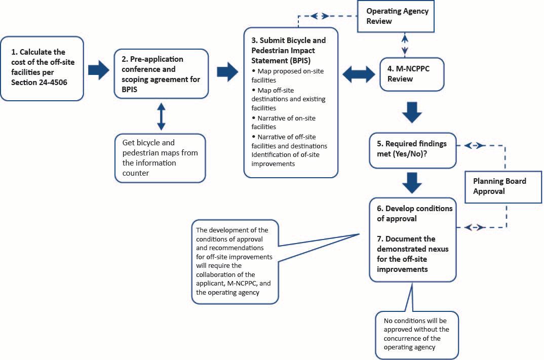
61of79: Transportation Review Guidelines
Page
Figure 1: Required Steps in the Bicycle and Pedestrian Analysis for Subdivisions
Table 12: Bicycle and Pedestrian Impact Statement (BPIS) Scoping Agreement
This form must be completed prior to preparation of the Bicycle and Pedestrian Impact Statement (BPIS) and approved by Transportation Planning Section (TPS) staff as part of the scoping for transportation and pedestrian/bicycle adequacy for the acceptance of Certificate of Adequacy applications (ADQ). The completed scoping agreement will be reviewed by the Planning Department during the scoping meeting. TPS will return a signed copy when all comments provided in the scoping meeting have been addressed and returned to the consultant for inclusion in the BPIS. Failure to conduct the study in accordance with the Transportation Review Guidelines (TRG) and the signed scoping agreement may be grounds for rejection of the study and thereby necessitate an addendum or a new study prior to the start of staff review.
Application Name:
Project
Subject Property Address (or Tax Account ID #):
Is a finding of adequate public pedestrian and bikeway facilities required per Section 244506(b)(3) of the Subdivision Regulations or a General Plan Center of Corridor Name per Section 24-124.01 of the prior Subdivision regulations? If so, a BPIS is required. Please provide specific criteria for BPIS review or provide justification if a BPIS is not applicable.
Applicant (or Consultant) Contact Information: Date of Scoping Agreement Submission:
Project Description and Cost Cap
1. Proposed Use:
2. Gross square feet of commercial or retail development (SF):
3. Number of Dwelling Units (DU):
The cost cap for required off-site pedestrian and bikeway facilities shall not exceed thirty-five cents ($0.35) per gross square foot of commercial or retail development proposed and three hundred dollars ($300) per unit of residential development, indexed for inflation.
4. Base Cost Cap ($0.35 per SF + $300 per DU):
5. Cost Cap Indexed for Inflation, using Bureau of Labor Statistics Consumer Price Index between June 2013 and Present: (https://www.bls.gov/data/inflation_calculator.htm)
62of79: Transportation Review Guidelines
Page
BPIS Scope
This agreement summarizes the geographic extent that is necessary for detailed review as part of the BPIS. Additional corridors or areas that are not listed below but are within walking or bicycling distance of the subject property may also be included in the BPIS. The submitted BPIS must also include pedestrian and bikeway facilities necessary to meet adequacy within the proposed subdivision (on-site).
6. Date of Pre-Application Scoping Meeting:
7. BPIS Map Included:
8. Potential Pedestrian or Bicycle Trip Generators within 1 Mile of Subject Property: (List all relevant g enerators.)
9. Proposed Corridors for BPIS Review within the Vicinity of the Subject Site: (Provide the name of each roadway/shared-use path corridor and its extents )
10. Master Plan Pedestrian and/or Bicycle Facility Recommendations along Subject Property Frontage or along Proposed Corridors: (See list above.)
11. Have any discussions with relevant permitting agencies (Department of Permitting, Inspections and Enforcement (DPIE), SHA, Municipalities, Washington Metropolitan Area Transit Authority (WMATA), etc.) occurred?
12. If a bikeshare station is proposed for this application, has a written confirmation and approval for that bikeshare station from DPW&T staff been submitted?
Prior to application acceptance, a written approval from DPW&T must be submitted.
Scope Agreement and Approval
SIGNED: _______________________________ Date: Applicant Consultant
APPROVED: ______________________________ Date: TPS Coordinator (or Supervisor)
For Staff Use Only
Okay to Accept Certificate of Adequacy Application?
If NO, please provide the following additional information:
Yes No
Yes No
Yes No
Yes No
63of79: Transportation Review Guidelines
Page
Required steps in the bicycle and pedestrian analysis for subdivisions within applicable zoning:
1. Calculate the cost cap for the off-site facilities. Based on the development yields proposed for the subject subdivision, the applicant shall calculate the cost cap for the off-site pedestrian or bikeway facilities consistent with Section 24-4506, which states that the cost of the off-site pedestrian or bikeway facilities shall not exceed thirty-five cents ($0.35) per gross square foot of proposed nonresidential development in the application and three hundred dollars ($300.00) per unit of proposed residential development in the application, indexed for inflation annually from calendar year 2013. For the purposes of these TRG and Supplement, on-site facilities include improvements within the subject subdivision and along the frontage of the subject site on all existing or planned roads. Off-site improvements are any improvements that are not within the subject site or along any of its associated road frontages.
2. Hold a pre-application conference and have scoping agreement signed. Before submitting the preliminary plan, the applicant for the subject subdivision within designated TSAs, Local Centers, and Regional Transit Districts should meet with TPS staff to (1) discuss what will be submitted for the BPIS, (2) identify potential off-site pedestrian destinations, and (3) discuss how off-site dollars will be spent. Applicable recommendations in the Master Plan of Transportation (MPOT) should be reviewed, nearby pedestrian or bicycle trip generators should be identified, and possible off-site improvements should be discussed. As a result of this meeting, a scoping agreement for the bicycle and pedestrian analysis should be signed prior to plan acceptance. A sample scoping agreement is included in the prior guidelines.
3. Submit the Bicycle and Pedestrian Impact Statement (BPIS). The applicant shall submit the BPIS at the same time they submit an application for a Certificate of Adequacy. This study will summarize how the subject application implements MPOT’s complete street policies on-site and address how the applicant proposes to utilize the required off-site dollars as calculated in Step 1 and refined in the pre-application meeting. The BPIS will also be the applicant’s proposal for how the submitted preliminary plan meets the required findings included in Section 24-4506. At a minimum, the BPIS will include four main elements:
• Map(s) of existing and proposed facilities
• Narrative or summary of the planned on-site facilities
• Narrative or summary of the off-site facilities within 0.5 miles of the subject property
• Identification of the necessary off-site improvements.
Each of the above requirements is described in more detail below. At a minimum, the BPI S will include the following information:
A. Mapping. Maps for subdivision applications within the applicable zones will be generated by the Planning Department Planning Information Services team for use in the BPIS, the staff report, and the Planning Board presentation. These maps will utilize existing GIS data to identify the existing and planned master plan trails network, the existing sidewalk network, and potential bicycle and pedestrian destinations in the vicinity of the subject site. This map (or series of maps) should show the subject site, on-site sidewalks, trails and bikeways, and the existing bicycle and pedestrian facilities within 0.5 miles of the subject site The map or
Page
64of79: Transportation Review Guidelines
maps should also identify all appropriate bicycle or pedestrian destinations within 1.0 mile of the subject site. More specifically, this map should include:
i. Vicinity map showing the off-site destinations within 1.0 mile of the subject site, including public schools, parks, libraries, stores, shopping centers, services, transit stops, transit lines within available rights-of-way, and other destinations for all users. This can be a letter-sized map with the subject site in the center and the various facilities and trip generators around it. This map should identify the potential pedestrian and/or bicycle trip generators within 1.0 mile of the subject site.
ii. Map the on-site sidewalk, hiking trail, and trail facilities. The map should highlight the major facilities proposed on-site and their relationship to the offsite facilities and destinations.
iii. Existing bicycle and pedestrian facilities within 0.5 miles of the subject site, as outlined in Section 24-4506. The facilities listed in this section include, but are not limited to, street lighting, standard or wide sidewalks, crossing signals, street trees, pedestrian refuges, marked crosswalks, bus stops, designated bike lanes, bikeways, and rails.
Note: The existing and proposed master plan bicycle and trail facilities, the existing sidewalk network, and the location of existing and proposed train stations Amtrak, MARC, Purple Line, and the Washington Metropolitan Area Transit Authority (WMATA) can be found at PGAtlas.com. The focus of additional research or field work should be the primary routes to the off-site destinations and/or the routes where the applicant is proposing off-site improvements.
B. On-Site Bicycle and Pedestrian Network Evaluation. The narrative of the BPIS should include a summary and analysis of the on-site bicycle and pedestrian network that explains and expands upon what is depicted in the maps. This narrative is the applicant’s opportunity to explain how the subject application fulfills the principles, policies, and recommendations of the complete streets element of MPOT by providing on-road bicycle facilities, sidewalks, and trails on the site or along the site’s road frontages. This evaluation should include:
i. Description of the proposed internal sidewalk network. Are sidewalks provided along both sides of all internal roads and along all road frontages? ls sidewalk access provided to all pedestrian destinations on the site? Are crosswalks and ADA curb cuts and ramps provided at all appropriate locations?
ii. Summary of how bicycles are accommodated on-site. What type(s) of on-road facilities are provided (for example, bike lanes, paved shoulders, wide outside curb lanes, shared-use roads, side path, cycle tracks)? Is bicycle parking provided? Are projected automobile travel speeds compatible with on-road bicycle traffic?
iii. Description of on-site transit facilities. Are there any existing or proposed bus stops or transit stations on the subject site? If so, is adequate pedestrian and bicycle access provided?
iv. Summary of master plan recommendations. How are applicable master plan bicycle or trail recommendations accommodated on-site or along the subject application’s associated road frontages?
Page 65of79
Review
: Transportation
Guidelines
v. Local trail connections. Are trail connections provided between otherwise isolated development pods? Is connectivity provided to adjacent properties where feasible?
vi. Complete streets checklist completed by the applicant. This checklist will help identify the facilities being provided on-site and gauge compliance with the principles and policies of MPOT. The completed checklist should be included as an appendix to the BPIS.
C. Off-site bicycle and pedestrian network evaluation. The applicant will also include a narrative of the main pedestrian or bicycle routes within 0.5 miles of the subject site to the previously identified destinations consistent with Section 24-4506. This evaluation will inform all stakeholders about where pedestrian trips generated from the subdivision are likely to walk and where on- and off-site connections may be warranted. For each off-site destination identified, the following will be evaluated:
i. Are continuous sidewalks provided between the subject site and the off-site destination? Are sidewalks missing along some or all of the primary routes to the destination? Are crosswalks and ADA curb cuts and ramps provided along the route?
ii. Are continuous bicycle facilities provided between the subject site and the offsite destination? Are there gaps in the bicycle facilities or barriers to bicycle movement to the destination? Is bicycle parking provided at the off-site destination?
iii. Does continuous street lighting that meets or exceeds County standards exist between the subject site and the off-site destination?
D. Identification of off-site improvements. The provision of off-site bicycle and pedestrian improvements should be based on the evaluation required in Step 3 and must comply with the cost cap determined by Step 1. The type(s) of off-site improvements should be consistent with Section 24-4506:
Examples of pedestrian and bikeway facilities that a developer/property owner may be required to construct shall include, but not be limited to (descending order of preference):
i. Installing or improving sidewalks, including curbs and gutters, and increasing safe pedestrian crossing opportunities at all intersections;
ii. Installing protected bicycle facilities, using on- street parking or medians to separate bicycle traffic from motor vehicle traffic;
iii. Installing or improving streetlights;
iv. Building paved multi-use trails, bike paths, and/or pedestrian pathways and crossings;
v. Building “bulb-out” curb extensions, pedestrian refuge medians, and pedestrian crossing signals at intersections;
vi. Installing a bicycle share station operated by DPW&T or a municipality;
vii. Installing covered bicycle parking;
viii. Installing street furniture (benches, trash receptacles, bicycle repair stations, bus shelters, etc.);
ix. Installing street trees and planted medians; and
Page 66of79
Review
: Transportation
Guidelines
x. One hundred percent (100%) engineering or design plans for nearby pedestrian or bikeway improvements to be constructed by the Department of Public Works and Transportation or trail projects to be constructed by the Department of Parks and Recreation or a municipality.
To be included as part of the subdivision approval, the off-site improvement(s) must meet the following criteria:
1. Utilize the funds identified in Step 1 and required by Section 24- 4506; a cost estimate for the proposed off-site improvements shall be provided
2. Improve connectivity to the subject site with one of the off-site destinations identified in Step 2, Step 3, and Section 24- 4506.
3. Be within available right-of-way per Section 24-4506
4. Be deemed feasible and agreed to by the applicable road agency or municipality.
5. A cost estimate for the off-site improvement shall be provided and included in the bonding for the to tal road improvements required by the appropriate road agencies.
The list of facilities included in Section 24-4506(c)(1)(E), in descending order of preference, provides examples of the types of improvements that may be required by the Planning Board to satisfy adequacy. Complete street treatments and improvements provide more detail to the broad categories included in the Subdivision Regulations. The complete streets section of MPOT and the complete streets table developed as part of the Central Avenue-Metro Blue Line Corridor Transit-Oriented Development (TOD) Implementation Project include an extensive array and diversity of treatments that may be considered, depending upon the needs of the site, environmental or right-of-way constraints, goals of the operating agency, and applicable law. The treatment or improvement that is appropriate in one subdivision may not be appropriate at another site with different challenges and constraints. The applicant, Planning Department staff, and operating agencies must work together to identify appropriate site-specific and context-sensitive improvements.
The complete streets menu included in the MPOT is intended to serve as a guide for planners, developers, and operating agencies as they identify treatments that will be most effective on a case-bycase basis. If adequate bicycle or pedestrian facilities are lacking within or near a subdivision, the Planning Department, operating agency, and developer/applicant should work from Table 1 from Part 1 of the updated TRG to identify appropriate solutions for the subdivision. The facilities recommended in MPOT should be considered to address pedestrian and bicycle trips both on-site and off-site.
4. The Planning Department evaluation. The evaluation by the TPS trails planner will focus on implementing the recommendations of MPOT and/or applicable area master plan. Staff will also evaluate the subdivision proposal for conformance with the complete street policies and strategies of MPOT. As part of ensuring that the subdivision complies with these policies, staff will complete the checklist and make appropriate recommendations (if any) to address deficiencies. Planning Department staff will review the BPIS and associated proposals to ensure compliance with the master plan and the required findings.
The BPIS will be referred to the appropriate road agencies and/or municipalities. The collaboration of the Planning Department and these agencies will (1) identify all off-site pedestrian trip generators, pedestrian safety needs, and sidewalk gaps, (2) review facilities proposed by the applicant for
67of79: Transportation Review Guidelines
Page
compliance with complete street principles and other applicable County standards, and (3) ensure that the road agency concurs with the off-site improvements proposed by the applicant. If no off-site improvements are feasible or practical due to environmental constraints, lack of public right-of-way, costs exceeding the cost cap, concerns of the operating agency, or other constraints, this shall be documented in the technical staff report
5. Required Findings. The Planning Department will utilize the submitted BPIS, the review of the preliminary plan, and the complete streets checklist to ensure compliance with Section 24- 4506. This section includes required findings for both pedestrian and bicycle facilities. The required findings include Section 24-4506:
(b) Applicability
(3) Before any preliminary plan of subdivision (minor or major) may be approved for any development applications proposing 11 (eleven) or more new or redeveloped dwelling units and/or otherwise proposing 10,001 or greater square feet of new or redeveloped gross floor area on land lying, in whole or part, within the RMF-20, RMF-48, NAC, TAC, LTO, RTO-L, RTO-H, CN, CGO, CS, NAC-PD, TAC-PD, LTO-PD, RTO-PD, LMXC, LMUTC, and LCD zones, the Planning Director shall find that there will be adequate public pedestrian and bikeway facilities to serve the proposed subdivision and the surrounding area.
(c)(1)(C) The finding of adequacy public pedestrian facilities shall, at minimum, include the following criteria:
(i) The degree to which the sidewalks, streetlights, street trees, street furniture, and other streetscape features recommended in the Countywide Master Plan of Transportation and the applicable area master plan or sector plan have been constructed or implemented in the area; and
(ii) The presence of elements that make it safer, easier, and more inviting for people to traverse the area.
(D) The finding of adequate public bikeway facilities shall, at minimum, include the following criteria:
(i) The degree to which the bike lanes, bikeways, and trails recommended in the Countywide Master Plan of Transportation and the applicable area master plan or sector plan have been constructed or implemented in the area;
(ii) The presence of specially marked and striped bike lanes or buffered bike lanes in which people can safely travel by bicycle without unnecessarily conflicting with pedestrians or motorized vehicles;
(iii) The degree to which protected bicycle lanes, on street vehicle parking, medians, or other physical buffers exist to make it safer or more inviting for people to traverse the area by bicycle; and
(iv) The availability of safe, accessible, and adequate bicycle parking at transit stops, commercial areas, employment centers, multifamily residential buildings, mixed-use activity centers, and other places where vehicle parking, visitors, and/or patrons are normally anticipated.
Compliance with Section 24-4506 will either be found or appropriate conditions of approval will be developed to address any deficiencies identified by the checklist, BPIS, or staff review. The subdivision
68of79: Transportation Review Guidelines
Page
will either meet the requirements of the section or it will meet the requirements with the placement of appropriate conditions.
The technical staff report will summarize how the subject application meets each of the required findings. If one or more of the findings is not met, the report will summarize why the finding was not met and how the conditions of approval will remedy the inadequacy.
The Subdivision Regulations, described previously, govern the evaluation of adequate bicycle and pedestrian facilities. However, a variety of details, amenities, design features, and facilities need to be considered and evaluated when attempting to determine the overall adequacy of the bicycle and pedestrian environment. These issues and questions will guide how the Planning Department evaluates subdivision applications and determines if additional accommodations for bicyclists and pedestrians are needed. As noted in the Zoning Ordinance, compliance with master plan pedestrian, bicycl e, and trail recommendations is a priority. However, the overall network of sidewalks, on-road bicycle accommodations, and off-site connections to nearby destinations (such as parks and schools) also need to be considered.
The entire subdivision will be evaluated for conformance with applicable law (including master plan compliance), for the provision of bicycle and pedestrian accommodations throughout, and for the existence of adequate access and facilities for transit. The complete streets checklist is designed to guide the applicant, engineers, and planners through a series of questions that clarify what facilities are provided, that identify nearby pedestrian destinations, and that ensure new roads are constructed to accommodate all users. When facilities are lacking or safety issues are identified, the complete streets table is intended to serve as a menu of improvements or enhancements that can be considered to address any existing deficiencies or safety issues. The complete streets checklist will be used to ensure compliance with the criteria for measuring bicycle and pedestrian adequacy included in Section 24-4506
6. Documentation of the demonstrated nexus. TPS staff will document the demonstrated nexus between the site and the related off-site improvement(s). This demonstrated nexus will be summarized in the memorandum from the TPS trails planner and included as a finding in the technical staff report and resolution of approval. Examples where a demonstrated nexus may be found include connections to public schools, parks, shopping centers, or transit lines. The discussion of the nexus should include how the off-site improvements will directly benefit future residents and/or employees of the subject development. A finding will be included in the resolution of approval that summarizes the demonstrated nexus between the subject site and the off-site improvement. Section 24-4506 (c) states,
1) As part of any development project requiring the subdivision or re-subdivision of land subject to the requirements of Section 24-4506(b)(3), above, the Planning Director shall require the developer/property owner to construct adequate pedestrian and bikeway facilities (to the extent such facilities do not already exist):
(A) Throughout the proposed subdivision; an d
(B) Within one- half mile of the subdivision if the Board finds that there is a demonstrated nexus to require the applicant to connect a pedestrian or bikeway facility to a nearby destination, including but not limited to a public school, park, shopping center, multifamily residence, mixed-use activity centers, or line of transit within available public rights of way.
Page 69of79
: Transportation Review Guidelines
7. Bicycle, pedestrian, and trail conditions of approval. TPS staff will work with the operating agencies to develop conditions of approval to address applicable MPOT or area master plan recommendations and ensure compliance with the required findings found in Section 24-4506. These conditions of approval will address on-site facilities, facilities along the subject s ite's road frontages, and the required off-site improvements identified in the BPIS. As noted in prior guidelines, Any improvement or enhancement deemed to be not feasible, or not supported by the appropriate operating agency or entity, will not be conditioned by the Planning Board.
Page
70of79: Transportation Review Guidelines
Section 3: Complete Streets
Please refer to the 2012 Transportation Review Guidelines (TRG), Part 1, for this section. Most of this section remains unchanged from the prior guidelines, with the following exceptions:
• References to Tiers have been replaced with Transportation Service Areas (TSAs), in accordance with Plan Prince George’s 2035 Approved General Plan (Plan 2035):
o The Developed Tier has been replaced by Transportation Service Area 1 (TSA 1). All centers are now equivalent to TSA 1, except Local Transit-Oriented (LTO) and Regional Transit-Oriented (RTO) core and edge areas, which have more relaxed critical lane volume (CLV) standards.
o The Developing Tier has been replaced by Transportation Service Area 2 (TSA 2).
o The Rural Tier has been replaced by Transportation Service Area 3 (TSA 3).
• References to Corridors are replaced by TSA 1, Local Centers, and Regional Transit Districts.
• References to the General Plan or Prince George’s County Approved General Plan are updated to Plan 2035
Page 71of79
: Transportation Review Guidelines
Section 4: Provisions and Clauses of Section 24-4506
In the prior Transportation Review Guidelines (TRG), this section provided the provisions and clauses of CB-2-2012. The Subdivision Regulations and Zoning Ordinance that took effect April 1, 2022, supersede CB-2-2012. This section summarizes Section 24-4506, or the Pedestrian and Bikeway Adequacy section of the Subdivision Regulations:
A. Purpose
This section establishes criteria to ensure adequacy of public pedestrian and bikeway facilities such as integrated sidewalk, trail, and bikeway facilities to divert automobile trips and increase the multimodal accessibility and attractiveness of trips to transit stops, schools, parks, libraries, stores, services, residences, and other destinations for all users. Pedestrian and bikeway facilities should be designed to increase safety for people walking, bicycling, and using transit, and these facilities should offer the most direct routes to destinations for persons of all abilities .
B. Applicability
As mentioned elsewhere in this section, a certificate for pedestrian and bikeway adequacy shall be reviewed and approved, approved with conditions, or denied per Section 24-4503. For approval of bicycle and pedestrian adequacy, the applicant must demonstrate that the proposed development meets the adequacy requirements and standards set in Section 24-4506.
The planning director must find that there will be adequate public pedestrian and bikeway facilities to serve the proposed subdivision and surrounding areas for developments proposing 11 or more new or redeveloped dwelling units and/or proposing 10,001 or greater square feet of new or redeveloped gross floor area on land lying in whole or part within the following zoning classifications: RMF-20, RMF-48, NAC, TAC, LTO, RTO-L, RTO-H, CN, CGO, CS, NAC-PD, TAC-PD, LTO-PD, RTO- PD, LMXC, LMUTC, and LCD zones.
C. Adequacy Standards for Pedestrian and Bicycle Facilities
As part of any development project requiring subdivision or re-subdivision of land, the planning director shall require the developer/property owner to construct adequate pedestrian and bikeway facilities (to the extent such facilities do not already exist)
• Throughout the proposed subdivision
• Within 0.5 miles of the subdivision if the Planning Board finds that there is a demonstrated nexus that requires the applicant to connect a pedestrian or bikeway facility to a nearby destination, such as a public school, park, shopping center, multifamily residence, mixed-use activity centers, or transit line within available public rights-of-way.
Page 72of79
: Transportation Review Guidelines
At a minimum, the finding of public pedestrian facilities shall include the following criteria, per Section 4506(c)(1)(C):
(i) The degree to which the sidewalks, streetlights, street trees, street furniture, and other streetscape features recommended in the Countywide Master Plan of Transportation and the applicable area master plan or sector plan have been constructed or implemented in the area; and
(ii) The presence of elements that make it safer, easier, and more inviting for people to traverse the area.
At a minimum, the finding of adequate public bikeway facilities must include, per Section 4506(c)(1)(D):
(i) The degree to which the bike lanes, bikeways, and trails recommended in the Countywide Master Plan of Transportation and the applicable area master plan or sector plan have been constructed or implemented in the area;
(ii) The presence of specially marked and striped bike lanes or buffered bike lanes in which people can safely travel by bicycle without unnecessarily conflicting with pedestrians or motorized vehicles;
(iii) The degree to which protected bicycle lanes, on street vehicle parking, medians, or other physical buffers exist to make it safer or more inviting for people to traverse the area by bicycle; and
(iv) The availability of safe, accessible, and adequate bicycle parking at transit stops, commercial areas, employment centers, multifamily residential buildings, mixed-use activity centers, and other places where vehicle parking, visitors, and/or patrons are normally anticipated.
Applicants are expected to use best design practices based on guidance from, but not limited to, the Maryland Department of Transportation (MDOT), the Urban Street Design Guide and the Urban Bikeway Design Guide from the National Association of City Transportation Officials (NACTO), and Complete Streets: Best Policy and Implementation Practices from the American Planning Association's and National Complete Streets Coalition
Pedestrian and bikeway facilities that a developer or property owner may be required to construct include but are not limited to:
• Installing or improving sidewalks, including curbs and gutters, and increasing safe pedestrian crossing opportunities at all intersections;
• Installing protected bicycle facilities, using on-street parking or medians to separate bicycle traffic from motor vehicle traffic;
• Installing or improving streetlights;
• Building paved multi-use trails, bike paths, and/or pedestrian pathways and crossings;
• Building “bulb-out” curb extensions, pedestrian refuge medians, and pedestrian crossing signals at intersections;
• Installing a bicycle share station operated by the Department of Public Works and Transportation (DPW&T) or a municipality;
• Installing covered bicycle parking;
• Installing street furniture (benches, trash receptacles, bicycle repair stations, bus shelters, etc.);
Page 73of79: Transportation Review Guidelines
• Installing street trees and planted medians ; and
• One hundred percent (100%) engineering or design plans for nearby pedestrian or bikeway improvements to be constructed by the Department of Public Works and Transportation or trail projects to be constructed by the Department of Parks and Recreation or a municipality.
In addition, Section 24-4506(c) stipulates:
(G) If a detailed site plan (minor or major) approval is required for any development within the subdivision, the developer/property owner shall include, in addition to all other required information in the site plan, a pedestrian and bikeway facilities plan showing the exact location, size, dimensions, type, and description of all existing and proposed easements and rights-of -way and the appurtenant existing and proposed pedestrian and bikeway facilities throughout the subdivision and within the designated walking or biking distance of the subdivision specified in this section, along with the location, types, and description of improvements, property/lot lines, and owners that are within 50 feet of the subject easements and rights-of-way.
(H) Prior to the issuance of any building permit for development within the subdivision, the developer/property owner shall show that all required adequate pedestrian and bikeway facilities have full financial assurances, have been permitted for construction through the applicable operating agency's access permit process, and have an agreed upon timetable for construction and completion with the appropriate operating agency.
The County Code gives the planning director authority to require that applicants build pedestrian or bikeway facilities not stipulated in the County Code in Section 24-4506(c) if deemed necessary:
(I) Nothing contained within this Subsection shall be deemed to inhibit in any way the authority of the Planning Director to require a developer/property owner to construct pedestrian and bikeway facilities not otherwise listed in this section, if such facilities relate to the implementation of "complete streets" principles on roadways required to be improved, constructed, or reconstructed to accommodate motor vehicle traffic that would be generated by proposed subdivisions. Any such pedestrian and bikeway facilities constructed off-site, shall be subject to the cost limitations set forth in Section 24-4506(c)(1)(B).
D. Availability
To be counted toward available capacity, any pedestrian or bikeway improvements within 0.5 miles of the proposed subdivision must meet at least one of the following conditions:
1. Be operational at the time the application for a Certificate for Adequacy is submitted or be included on an adopted and approved functional master plan, area master plan, or sector plan; have construction scheduled; and have 100 percent of the construction funds allocated in the adopted County Capital Improvement Program (County CIP) or in the current State Consolidated Transportation Program (State CTP).
2. Be incorporated in a specific County Public Facilities Financing and Implementation Program (including the County CIP) with construction scheduled and 100 percent of the construction funds allocated
3. Be fully funded by the applicant, the County, and/or the State government
74of79: Transportation Review Guidelines
Page
APPENDIX A: References and Sources of Additional Information
This appendix is based on Appendix D from the 2013 Transportation Review Guidelines Part 2 has been updated to the most recent links.
Application of New Pedestrian Level of Service Measures, Sacramento Area Council of Governments. June 2011.
https://www.yumpu.com/en/document/view/25931702/application-of-new-pedestrian-level-ofservice-measures-sacog
Approved Countywide Master Plan of Transportation, Maryland-National Capital Park and Planning Commission, November 2009.
https://www.mncppc.org/1156/Transportation-Plans
Central Avenue-Metro Blue Line Corridor TOD Implementation Project, Maryland National Capital Park and Planning Commission, August 2012.
https://www.mncppc.org/DocumentCenter/View/844/Summary-and-Assessment-of-TOD-Plans-andDesign-Standards-Report-PDF
“It's a Safe Decision: Complete Streets in California.” National Complete Streets Coalition and the Local Government Commission. February 22, 2012.
Designing Sidewalks and Trails for Access Review of Existing Guidelines and Practices (Part I of II), US Department of Transportation, Federal Highway Administration, July 1999. https://nacto.org/docs/usdg/designing_sidewalks_trails_access_alexson.pdf
Bicycle Policy and Design Guidelines, Maryland State Highway Administration, Revised January 2015 https://www.roads.maryland.gov/ohd2/bike_policy_and_design_guide.pdf
Guidebook on Methods to Estimate Non-Motorized Travel: Overview of Methods. US Department of Transportation, Federal Highway Administration, July 1999. https://safety.fhwa.dot.gov/ped_bike/docs/guidebook2.pdf
Guide for the Development of Bicycle Facilities, American Association of State Highway and Transportation Officials, 2012 Fourth Edition https://nacto.org/wp-content/uploads/2015/04/AASHTO_Bicycle-Facilities-Guide_2012-toc.pdf
Multimodal level of Service (LOS) Methodology and Findings, Appendix K. Pikes Peak Area Council of Governments, November 2011. https://view.ckcest.cn/AllFiles/ZKBG/Pages/621/22494.pdf
Page 75of79: Transportation Review Guidelines
Naylor Road Metro Station Area Accessibility Study, Transportation Land-Use Connection (TLC) Program, Kittelson and Associates. May 2011. https://www.mwcog.org/assets/1/6/PG-Naylor.pdf
NCHRP (National Cooperative Highway Research Board) Report 616 Multimodal Level of Service Analysis for Urban Streets. Transportation Research Board of the National Academies, 2008.
New Carrollton Interim Pedestrian Safety Improvements, Transportation Land-Use Connection (TLC) Program, Kittelson and Associates, June 2010. https://www.mwcog.org/assets/1/6/NewCarrolltonPedSafety1.pdf
Prince George's Plaza Metro Station Area Pedestrian Safety and Access Study The Maryland-National Capital Park and Planning Commission Prince George's County Planning Department. https://www.mncppcapps.org/planning/publications/BookDetail.cfm?item_id=373&Category_id=2
Specifications and Standards for Roadways and Bridges Prince George's County, Maryland. Revised March 2012.
https://www.princegeorgescountymd.gov/DocumentCenter/View/4789/DPWT-Specifications-andStandards-for-Roadways-and-Bridges-PDF?bidId=
Transportation Review Guidelines Part 1. Maryland-National Capital Park and Planning Commission. 2012.
https://www.mncppc.org/DocumentCenter/View/2373/Transportation-Review-Guidelines Part-1PDF?bidId=
Transportation Review Guidelines Part 2. Maryland-National Capital Park and Planning Commission. 2013.
https://www.mncppc.org/DocumentCenter/View/2494/Transportation-Review-Guidelines Part-2-PDF
“Walkability Checklist Guidance for Entitlement Review,” City of Los Angeles Department of City Planning. November 2008.
http://urbandesignla.com/resources/LAWalkabilityChecklist.php
76of79: Transportation Review Guidelines
Page
APPENDIX B: Map of Transportation Service Areas
Source: Plan Prince George’s 2035 Approved General Plan For most up to date information on transportation service areas (TSAs) please refer to PGAtlas (http://www.pgatlas.com).
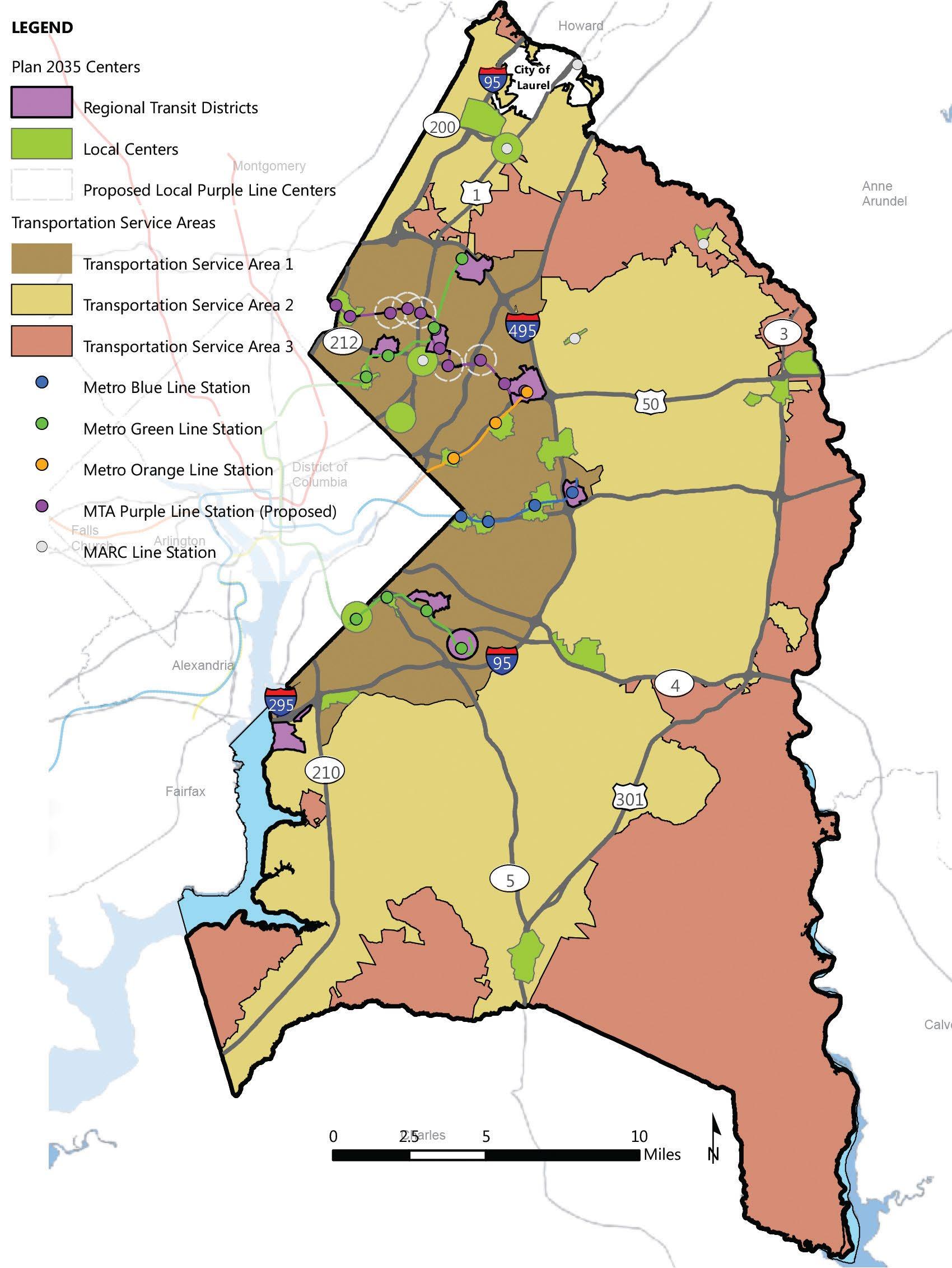
Page 77of79
Transportation Review Guidelines
:
APPENDIX C: New Ordinance Case Type Nomenclature For Dams
Case
Type
Alternative Compliance AC- ACL-
Certificate of Adequacy - ADQ-
Chesapeake Bay Critical Area Plan CP- CBP-
Chesapeake Bay Critical Area Zoning Map Amendment A- ZMAConservation Sketch Plan S- SKH-
Departure (Major)
Departure (Minor)
DDS- / DPLS- / DSDS- MJD-
DDS- / DPLS- / DSDS- MND-
Detailed Site Plan DSP- DET-
Final Plat of Subdivision 5- FPS-
Historic Agricultural Resources Preservation Program HARPP- HRP-
Mandatory Referral (Major) MR- MRF-
Mandatory Referral (Minor) MR- MRA-
MD Agricultural Land Foundation MALPF- MALPF-
Natural Resource Inventory NRI- NRI-
Certification of Nonconforming Use NCU- CNCPlanned Development Map Amendment - ZMA-
Pre-Alternative Compliance - PAC-
Preliminary Plan of Subdivision 4- PPSRequest to Build in Proposed Right-of-Way - ROW-
Secondary Amendment SA- SAP-
Special Exception SE- SPE-
Subdivision Ordinance Interpretation - SOI-
Tree Conservation Plan 1
Tree Conservation Plan 2
TCP1- TCP1-
TCP2- TCP2-
Tree Conservation Plan Exempt E- EVacation Petition V- VPT-
Water & Sewer Amendment WSA- WSAZoning Map Amendment A- ZMA-
Zoning Ordinance Interpretation - ZOI-
Zoning Certification Letter - ZCL-
Page 78of79: Transportation Review Guidelines
Old Ordinance Abbreviation New Ordinance Abbreviation

Prince George’s County Planning Department 14741 Governor Oden Bowie Drive Upper Marlboro, MD 20772 www.pgplanning.org
