Approved Southern Green Line Station Area Sector Plan with 2023 Minor Amendments
Abstract
Title: Approved Southern Green Line Station Area Sector Plan
Author: The Maryland-National Capital Park and Planning Commission
Subject: Approved Sector Plan and Sectional Map Amendment for Southern Green Line Station Area
Date: February 2014 (Amended October 2023)
Source of Copies: The Maryland-National Capital Park and Planning Commission 1616 McCormick Drive Largo, MD 20774 (301) 952-3195
Series Number: XXXXXXXXXXXXX
Number of Pages: 206
Abstract: The Approved Southern Green Line Station Area Sector Plan seeks to bring transit-oriented development to the four Metrorail station areas along the Southern Green Line: Branch Avenue, Suitland, Naylor Road, and Southern Avenue in order to maximize the potential for economic and community development, and identifies opportunities for infill and redevelopment, sets a vision for each station area, and makes recommendations for future land use, creation of new TransitOriented Development zoning districts, regional and local roadway projects, and pedestrian and bicycle facilities and outlines implementation strategies, including specific recommendations for rezoning.
Approved Southern Green Line Station Area Sector Plan
February 2014 (Amended October 2023)
The Maryland-National Capital Park and Planning Commission 1616 McCormick Drive
Largo, MD 20774 301-952-3972
www.pgplanning.org
The Maryland-National Capital Park and Planning Commission
Elizabeth M. Hewlett, Chairman
Françoise Carrier, Vice Chairman
Officers
Patricia Colihan Barney, Executive Director
Joseph Zimmerman, Secretary-Treasurer
Adrian R. Gardner, General Counsel
The Maryland-National Capital Park and Planning Commission is a bicounty agency, created by the General Assembly of Maryland in 1927. The Commission’s geographic authority extends to the great majority of Montgomery and Prince George’s Counties: the Maryland-Washington Regional District (M-NCPPC planning jurisdiction) comprises 1,001 square miles, while the Metropolitan District (parks) comprises 919 square miles, in the two counties.
The Commission has three major functions:
• The preparation, adoption, and, from time to time, amendment or extension of the 2002 Approved General Plan for Prince George’s County for the physical development of the Maryland Washington Regional District;
• The acquisition, development, operation, and maintenance of a public park system; and
• In Prince George’s County only, the operation of the entire county public recreation program.
The Commission operates in each county through a Planning Board appointed by and responsible to the county government. All local plans, recommendations on zoning amendments, administration of subdivision regulations, and general administration of parks are responsibilities of the Planning Boards.
Prince George’s County Planning Board Montgomery County Planning Board
Elizabeth M. Hewlett, Chairman Françoise Carrier, Chairman
Dorothy F. Bailey, Vice Chairman Marye Wells-Harley, Vice Chairman
Manuel R. Geraldo
John P. Shoaff
Casey Anderson
Norman Dreyfuss
A. Shuanise Washington Amy Presley
Prince George’s County
Rushern L. Baker, III, County Executive
County Council
The County Council has three main responsibilities in the planning process: (1) setting policy, (2) plan approval, and (3) plan implementation. Applicable policies are incorporated into area plans, functional plans, and the Prince George’s County Approved General Plan. The County Council, after holding a hearing on the plan adopted by the Planning Board, may approve the plan as adopted, approve the plan with amendments based on the public record, or disapprove the plan and return it to the Planning Board for revision. Implementation is primarily through adoption of the annual Capital Improvement Program, the annual budget, the water and sewer plan, and adoption of zoning map amendments.
Council Members
Mary A. Lehman, 1st District
Will Campos, 2nd District, Council Vice Chair
Eric Olson, 3rd District
Ingrid M. Turner, 4th District
Andrea C. Harrison, 5th District
Derrick Leon Davis, 6th District
Karen R. Toles, 7th District
Obie Patterson, 8th District
Mel Franklin, 9th District, Council Chair
Clerk of the Council
Redis C. Floyd
The work that provided the basis for this publication was supported by funding under an award with the U.S. Department of Housing and Urban Development. The substance and findings of the work are dedicated to the public. The author and publisher are solely responsible for the accuracy of the statements and interpretations contained in this publication. Such interpretations do not necessarily reflect the views of the Government.
Foreword
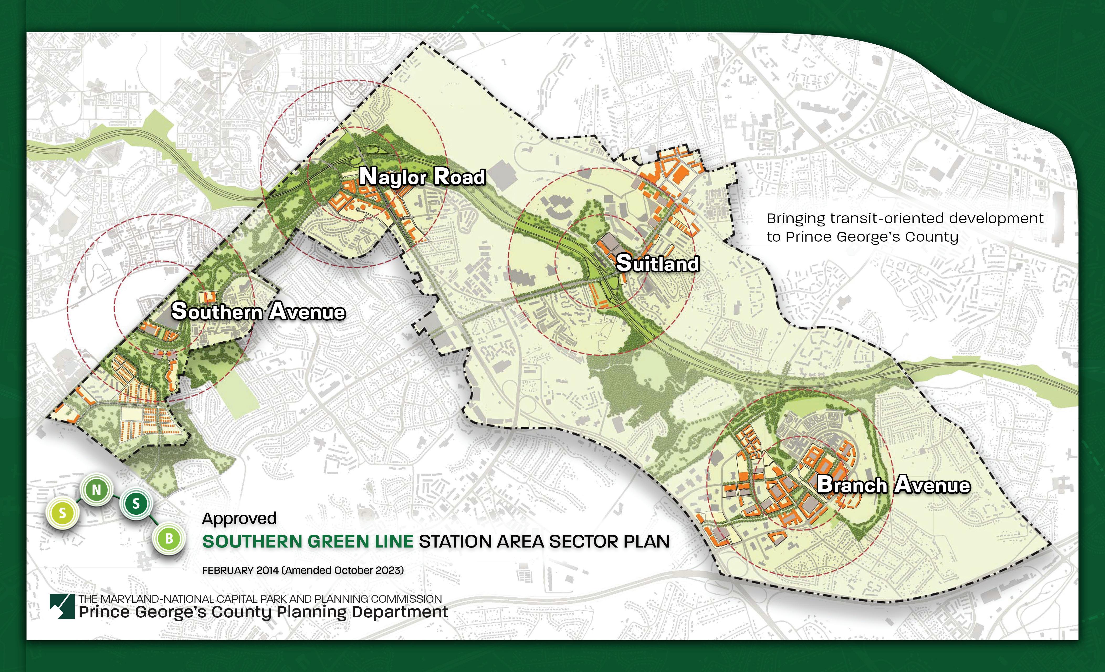
The Prince George’s County Planning Board of The Maryland-National Capital Park and Planning Commission is pleased to present the 2014 Approved Southern Green Line Station Area Sector Plan. This plan addresses opportunities to bring transit-oriented development (TOD) to the four Metrorail station areas along the Southern Green Line of the Metrorail system: Branch Avenue, Suitland, Naylor Road, and Southern Avenue. These stations are a major asset for Prince George’s County and the plan makes recommendations to maximize their value for economic and community development.
The 2014 Approved Southern Green Line Station Area Sector Plan replaces the 2013 Approved Central Branch Avenue Revitalization Sector Plan, the 2010 Approved Subregion 4 Master Plan, 2008 Approved Branch Avenue Corridor Sector Plan and 2000 Approved Master Plan for the Heights and Vicinity (Planning Area 76A), and amends the 2002 Approved General Plan and 2009 Approved Countywide Master Plan of Transportation for the portions of Planning Areas 75A and 76A within the Southern Green Line Station Area Sector.
Policy guidance for this plan came from the 2006 Suitland M-U-TC Development Plan, and County functional master plans, including the 2005 Approved Countywide Green Infrastructure Functional Master Plan, the 2008 Approved Public Safety Facilities Master Plan, the 2009 Approved Countywide Master Plan of Transportation, and the 2010 Approved Water Resources Functional Master Plan
The goals, concepts, guidelines and public participation program, approved by both the Planning Board and the Prince George’s County Council, sitting as the District Council in February and March 2012 outlined the major issues, challenges, and opportunities that informed the plan and helped to provide its structure. Public participation from October 2011 to February 2013 consisted of stakeholder outreach, including interviews with key landowners, developers, business owners, County and state officials, government agencies, and a series of community workshops.
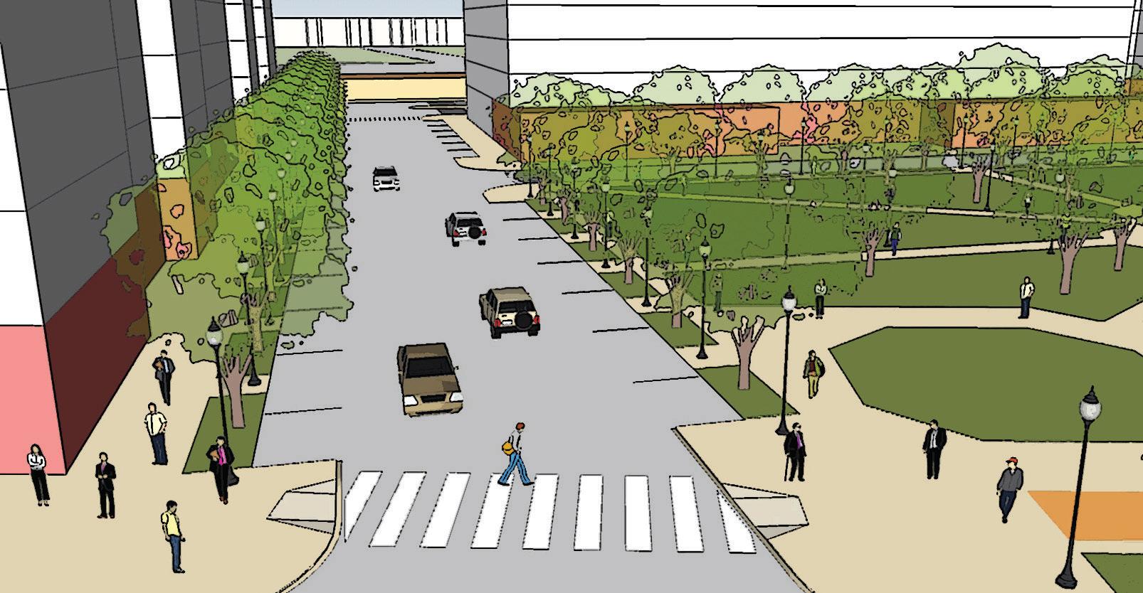
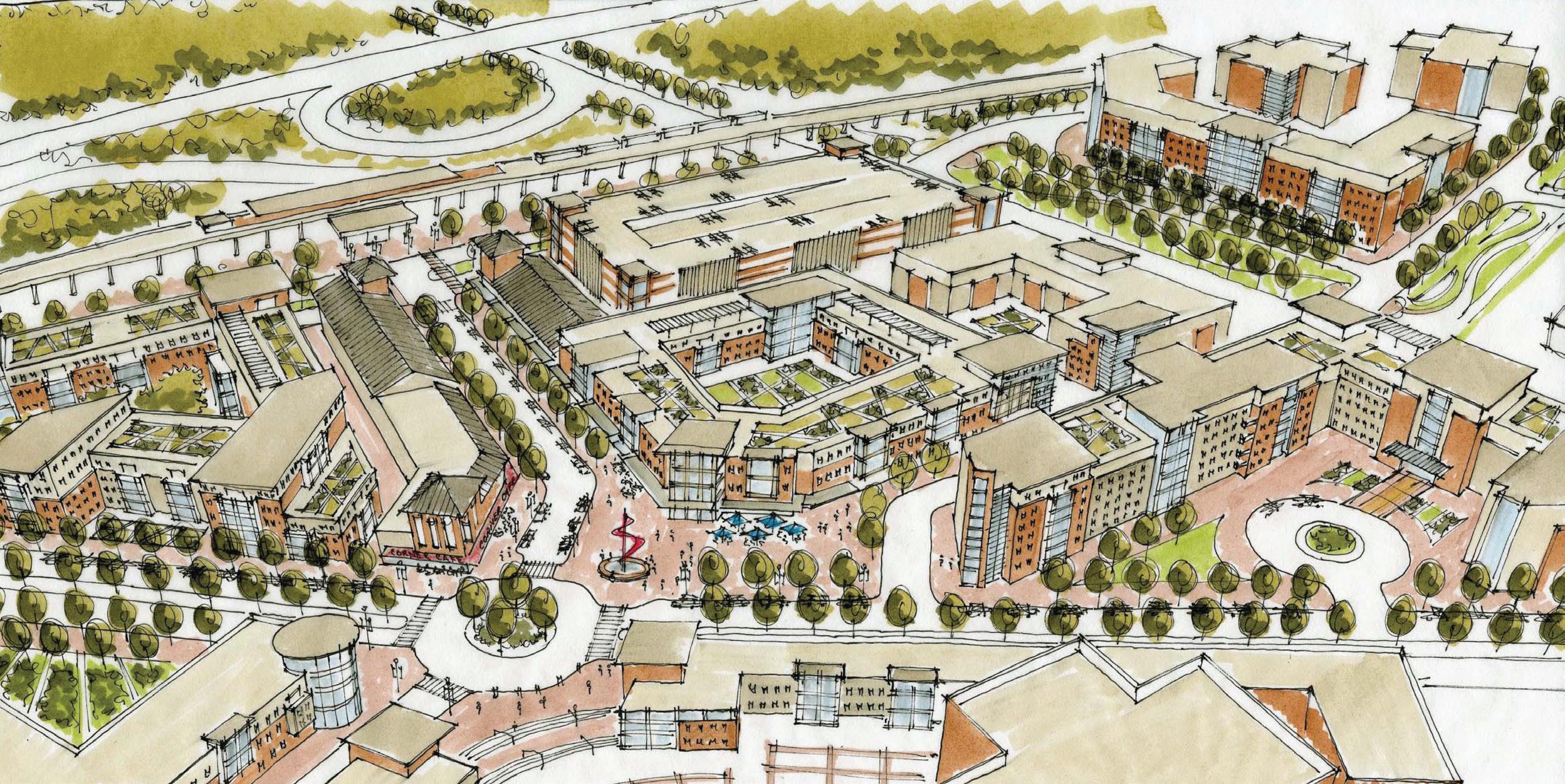
The Approved Southern Green Line Station Area Sector Plan sets a vision for each of the four stations based on a detailed real estate market analysis and the available opportunities for infill and redevelopment within an easy walk of the four Metro stations. The recommended future land use plan is carefully crafted to encourage creative response from developers by providing flexibility in use, while also guiding and shaping growth that is the right fit for each station, including reserving land at the Branch Avenue Metro Station area for the establishment of a regionally important employment center. Provision of pedestrian and bicycle facilities is a crucial component of creating transit-oriented development (TOD), and the plan makes detailed recommendations for improving non-motorized access to each of the four station areas.
Major projects to create a more integrated roadway network are also outlined, along with a basic recommendation to establish a grid of walkable streets around the stations. The plan also outlines implementation strategies, including conceptual recommendations for new TOD supportive zones.
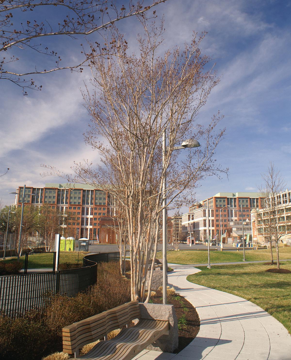
Placemaking, park, and urban design features are also included in the plans for each station, working with and improving on existing assets and landscape features. This plan envisions the Southern Green Line station area as a place to live, work, and shop with transit access and walkable neighborhoods at the center of community life. New investment in the immediate station areas will also support revitalization and conservation of existing residential areas.
On July 2, 2013, the Prince George’s County Planning Board and the District Council held a joint public hearing to solicit comments on the preliminary plan. The Planning Board adopted the plan on September 26, 2013, with modifications pursuant to PGCPB Resolution No. 13-98. The District Council held a work session and proposed amendments to the adopted plan. On January 14, 2014, a second joint public hearing was held on the proposed amendments. The District Council approved the sector plan per CR-9-2014 on February 25, 2014. A concurrent Sectional Map Amendment (SMA), including the reclassification of properties to facilitate plan implementation, was endorsed by the Planning Board through PGCPB No. 13-98 and approved by the District Council per CR-102014 on February 25, 2014. This Sectional Map Amendment was superseded in its entirety by the 2021 Approved Countywide Map Amendment. This sector plan was amended through CR-1032023 on October 24, 2023.
The Prince George’s County Planning Board appreciates the contribution and active involvement of the community and stakeholders in this innovative planning effort.
Sincerely,
Peter Shapiro Chair
Prince George’s County Planning Board
Chapter 4 Suitland Metro Station
Chapter 5 Naylor Road Metro Station
Chapter 6 Southern Avenue Metro Station
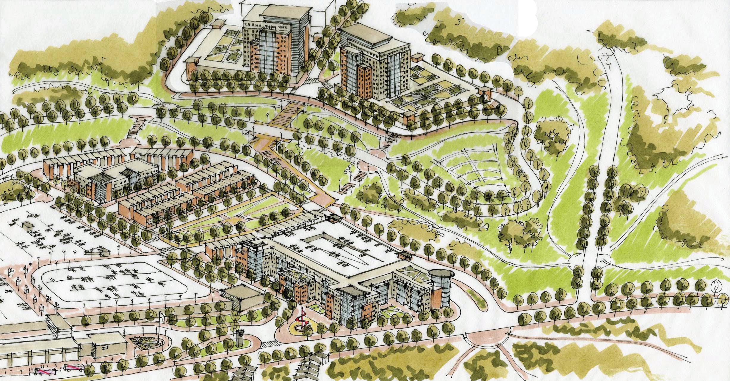
Figure 22: Branch Avenue Metro Station Area Overview 59
Figure 23: Branch Avenue Existing Land Use, 2012 ... 61
Figure 26: Branch Avenue Sidewalk Survey and Actual Walk Distance .................................................................................... 66
Figure 27: Branch Avenue TOD Opportunities and Challenges ........................................................................................... 67
Figure 28: Branch Avenue Phase Two Illustrative Development Concept Sketch ................................................. 69
Figure 29: Branch Avenue Illustrative Development Concept ................................................................................................. 70
Figure 30: Illustrative Development Concept ................. 71
Figure 31: Old Soper Road Illustrative Concept Sketch 72
Figure 32: Branch Avenue Districts and Illustrative Development Program Concept .............................................. 73
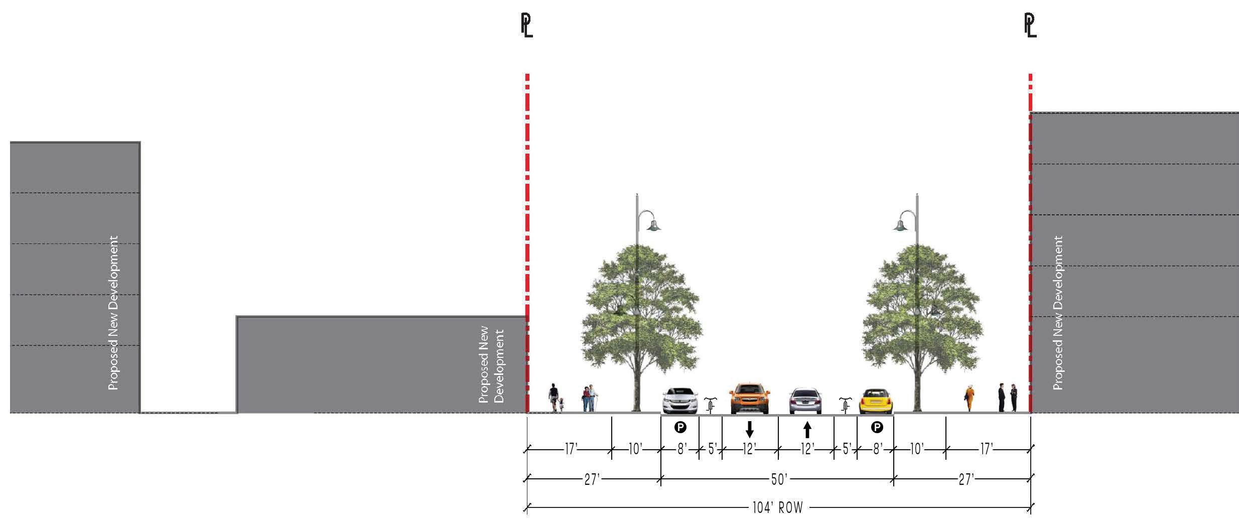
Figure 33: Old Soper Road, Illustrative Street Section Concept ................................................................................................. 74
Figure 34: Branch Avenue Phase One Illustrative Development Concept .................................................................. 75
Figure 35: Branch Avenue Phase One Parking Illustrative Concept......................................................................... 77
Figure 43: Branch Avenue Station Access and Circulation ............................................................................................ 88
Figure 44: Recommended Regency Parkway Crosstown Bus Route.................................................................... 89
Figure 45: Recommended MD 5 Express Bus Service Concept ................................................................................................. 90
..................................................................................138 Figure 71: Naylor Road TOD Opportunities and Challenges .........................................................................................139
Figure 72: Naylor Road Illustrative Development Concept ...............................................................................................142
Figure 74: Naylor Road Districts and Illustrative Development Program Concept ............................................144
Figure 75: Good Hope Avenue Extension Illustrative Street Section ..................................................................................145
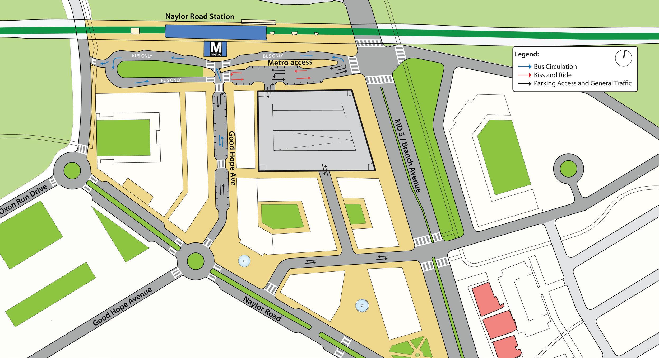
Figure 80: Naylor Road Metro Station Access and Circulation ..........................................................................................153
Figure 81: Recommended MD 5 Express Bus Service Concept ...............................................................................................154
Figure 87: Southern Avenue Sidewalk Survey and Actual Walk Distance ..................................................................168
Figure 88: Southern Avenue TOD Opportunities and Challenges .........................................................................................169
Figure 89: Southern Avenue Illustrative Development Concept ...............................................................................................172
Figure 90: Southern Avenue Districts and Illustrative Development Program Concept ............................................174
Table 5: Watersheds, Impervious Surfaces and Water Quality ...................................................................................................... 19
Table 6: Watersheds Countywide and Within the Sector Plan Area ................................................................................. 19
Table 7: Streams, Wetland, and Flood Plain....................... 20
Table 30: Parking Customer Travel Distances for Southern Avenue Station 167
Table 31: Southern Avenue Metro Recommended Bicycle and Pedestrian Facilities ......................................... 183
Table 32: Implementation Strategies Action Plan ....... 192
Introduction Chapter 1 Introduction
Why Plan?
The 2014 Approved Southern Green Line Station Area Sector Plan seeks to bring transit-oriented development (TOD) to southern Prince George’s County by way of the Metro Green Line. This transit line experienced more growth in jobs and households than any other transit line in the Washington Metropolitan Area between 2000 and 2010, although the District of Columbia realized most of this growth. However, the extension of this Metro line into southern Prince George’s County in 2001 has opened up an important new, but unrealized, opportunity for capturing a portion of projected regional growth, particularly TOD, over the next 20 years in this area of the County. Currently, the station areas are undeveloped and underdeveloped but offer sites of sufficient scale to create significant development projects within a tenminute ride to the District of Columbia. The transit line runs through older communities and commercial corridors where growth has been stagnant and where the best opportunity for revitalization and redevelopment rests with the ability of the Metro stations to attract TOD. This development model delivers higher property values, makes use of significant transit investments, is attractive to millennials and seniors, has positive environmental impacts, and is more sustainable. It integrates uses, is compact and walkable, and provides a range of housing, transit options and urban amenities.
This sector plan establishes a vision for the individual station areas, the sector plan area as a whole, and presents a comprehensive strategy for achieving TOD. The vision and strategy rely upon a real estate market analysis that measured growth potential and opportunity, and input from stakeholders, including all
levels of government, developers, property owners, civic organizations and area residents. The plan creates a tailored development program for each station that builds upon the station area assets and key characteristics and combines the essential elements of TOD. Additionally, the plan provides an implementation strategy that identifies immediate actions that will be necessary to facilitate short-term development opportunities as well as a longterm development scenario for the Metro corridor. Plan recommendations address urban design, land use and zoning, mobility and access, and public facilities
The plan recognizes the importance of preserving and enhancing existing communities within the sector plan area and integrating development opportunities around the four Metro stations. It leverages the area’s robust transit service and identifies opportunities for attracting new residents, shoppers, and major employers and it supports existing area businesses and government centers.
Partnership for Sustainable Communities
An opportunity to partner with the federal government through its Partnership for Sustainable Communities served as the impetus for the sector plan. The partnership seeks to help communities improve access to affordable housing and provide more transportation options while protecting the environment. In 2010, the Prince George’s County Planning Department of The Maryland-National Capital Park and Planning Commission (M-NCPPC) applied for and received a Challenge Grant from the federal Department of Housing and Urban Development (HUD) to prepare an action plan to bring TOD to the Southern Green Line Metro stations. Key planning objectives noted in the grant proposal were to increase the County’s share of regional job growth; address income, jobs, and transportation disparities; increase quality affordable housing through mixedincome projects; increase transportation options; improve reverse commuting patterns; enhance connectivity and
linkages to and between Metro stations; and stabilize and preserve nearby communities. As a grant recipient, the commission and County are required to align its planning effort with six livability principles that form the cornerstone of the partnership. The livability principles and the manner in which the sector plan seeks to achieve them are described below.
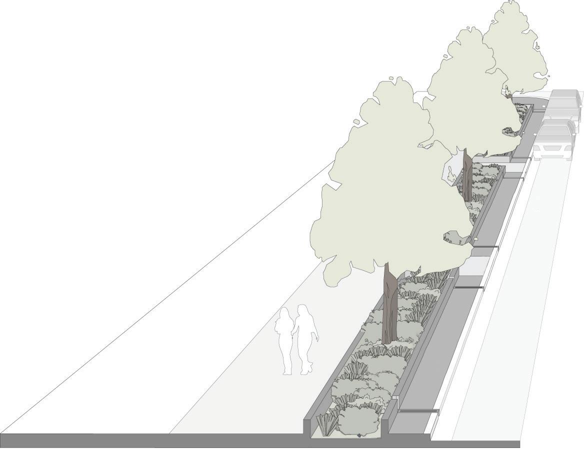
1. Provide More Transportation Choices: increasing transportation choices is a key recommendation of the sector plan. The plan recommends accommodating all modes of transportation including walking and bicycling to the stations through the provision of safe sidewalks, trails, and bicycle amenities; and to support bus transit to supplement existing rail transit; and promote the expansion and better coordination of bus routes to improve services to the stations.
2. Enhance Economic Competitiveness: the real estate market analysis suggests a changing marketplace and a strong opportunity within the sector plan area to accommodate a larger share of the region’s job and housing needs. Success will depend upon creating demand drivers for all land uses (multifamily residential, professional office, and lifestyle retail) that are necessary for TOD.
3. Promote Equitable, Affordable Housing: the plan recommends preserving market-rate affordable housing in existing neighborhoods as well as increasing mixed-income housing near the transit stations.
4. Support Existing Communities: recommendations to better connect existing communities to transit and to provide nearby opportunities for employment and greater housing options will benefit these communities. Additionally, higher-value TOD will help improve property values in adjacent communities, thereby creating opportunities for reinvestment.
5. Coordinate Policies and Leverage Investment: the planning process provided a unique opportunity for jurisdictions with a stake in the Metro corridor to work together towards TOD, including reconciling conflicting policies and priorities, coordinating programs and services, and collaborating on development opportunities.
6. Value Communities and Neighborhoods: the plan recommends an array of infrastructure improvements including road and trail extensions, new sidewalks, and new public facilities that will benefit surrounding and new transit communities.
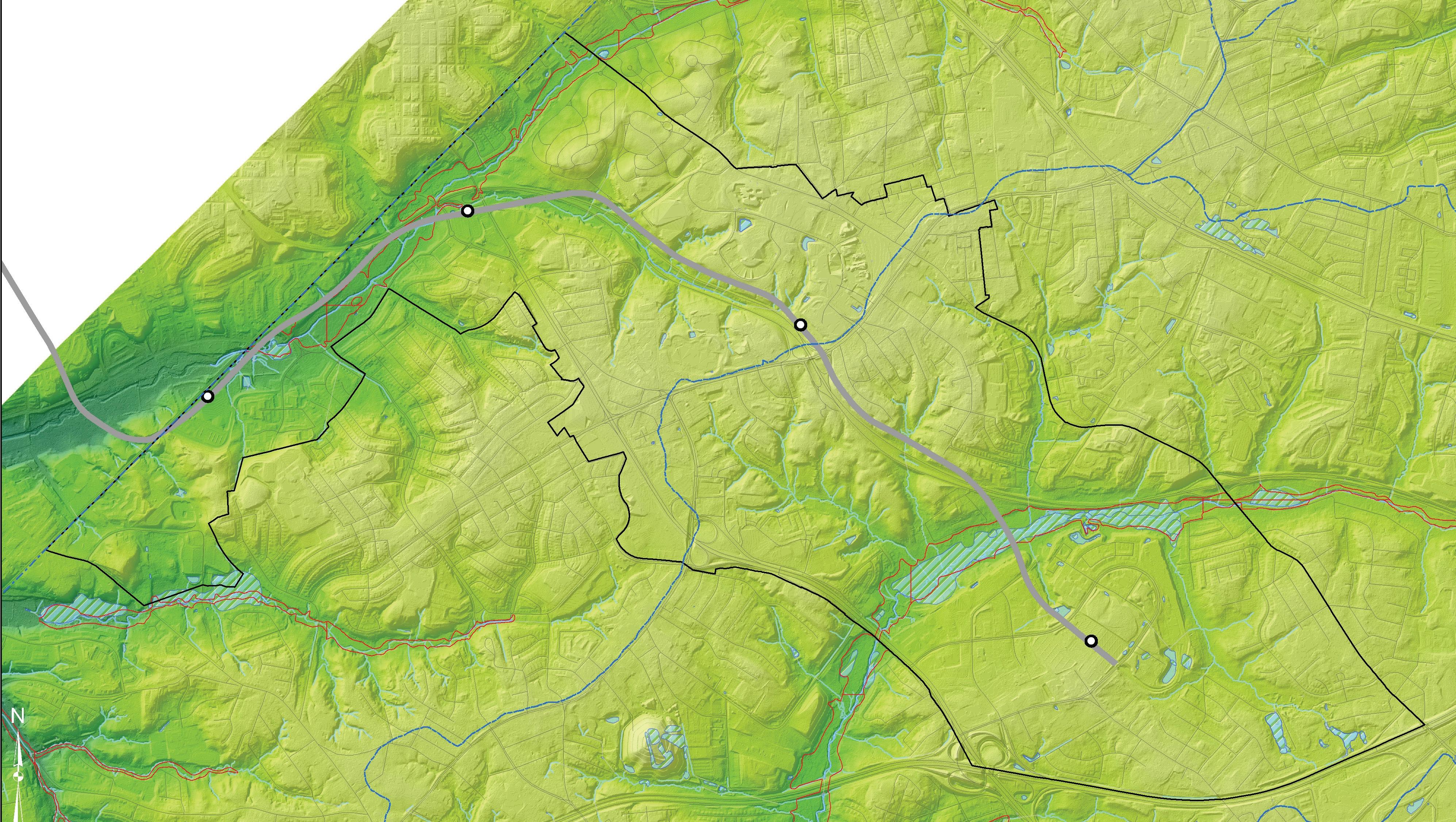
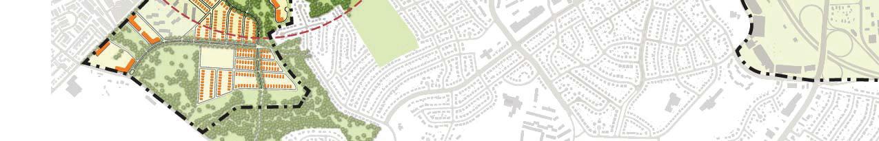
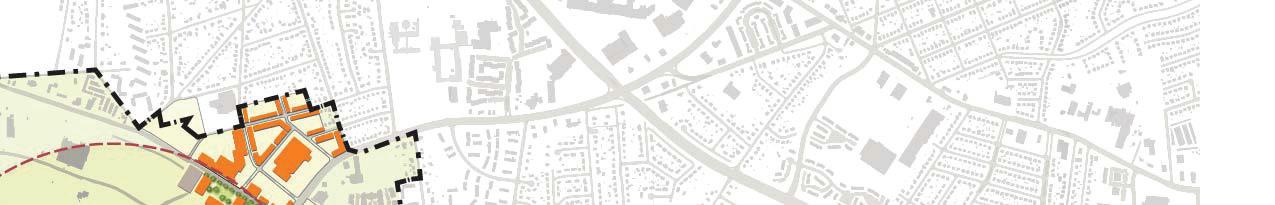
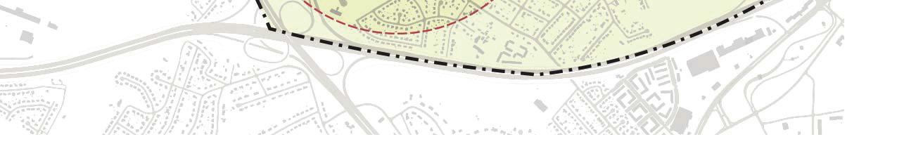
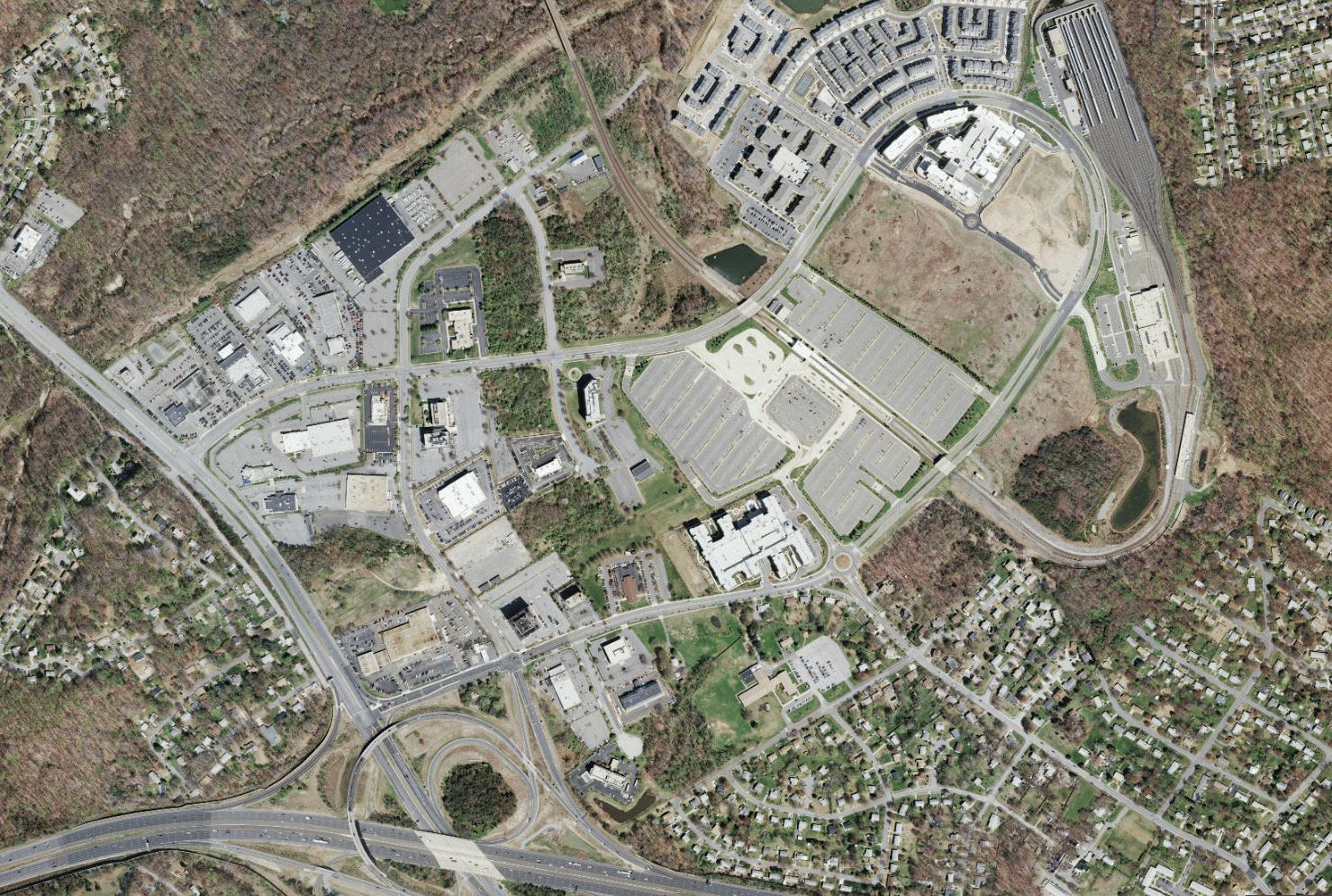
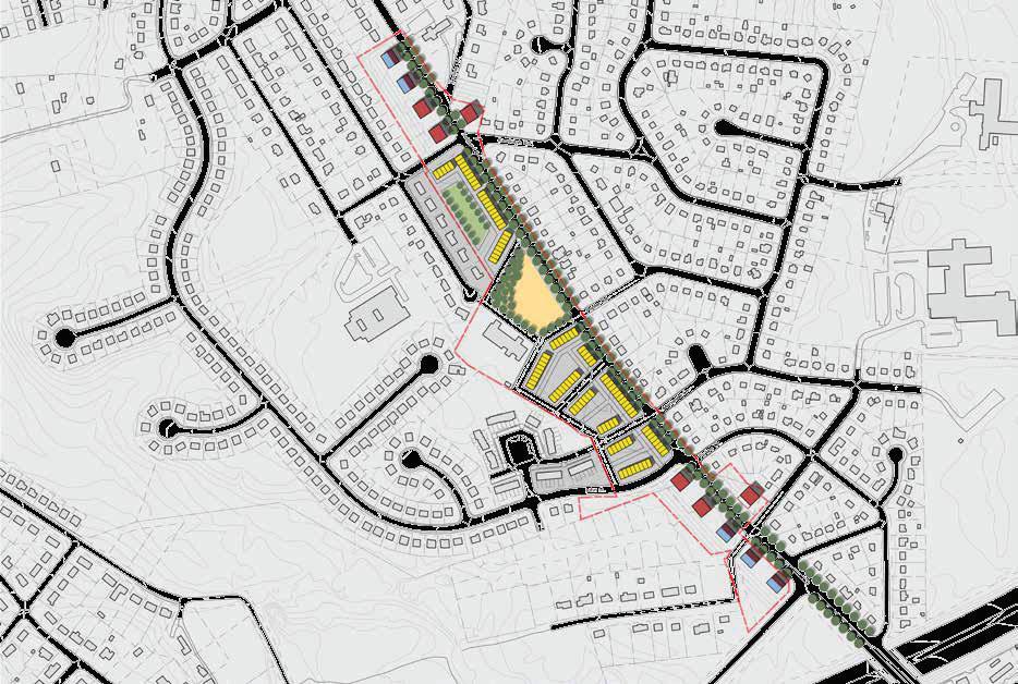
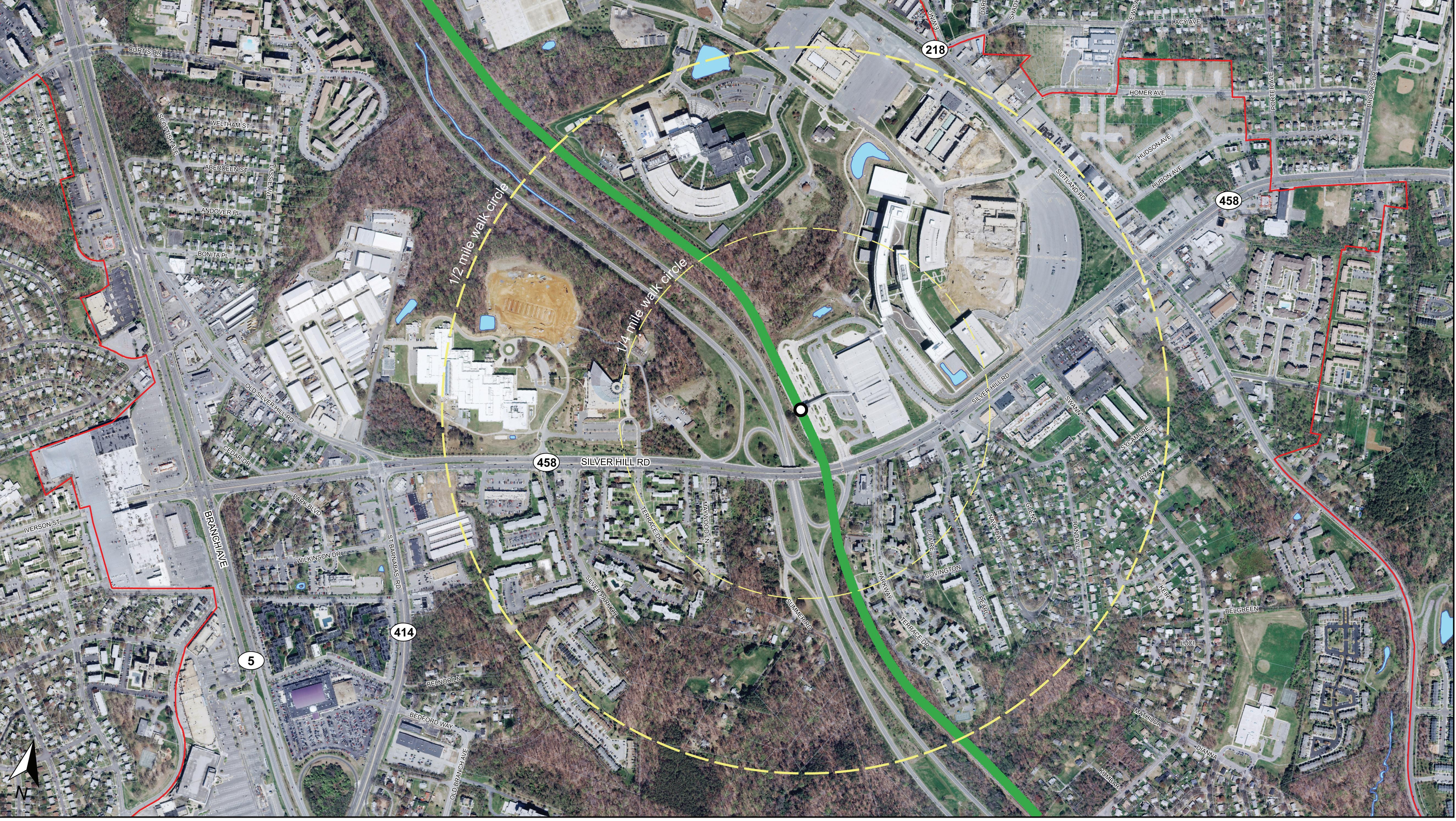
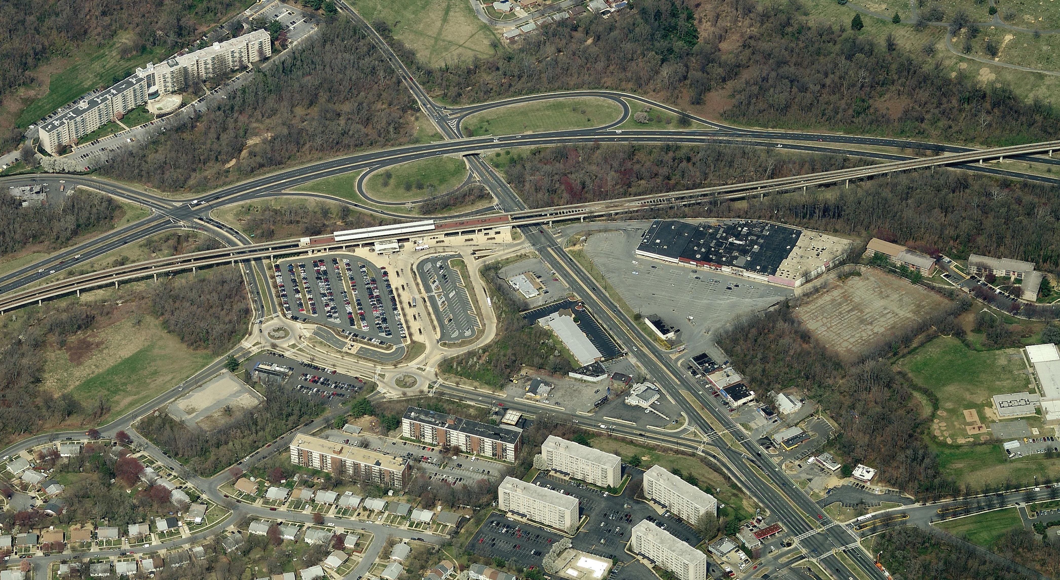
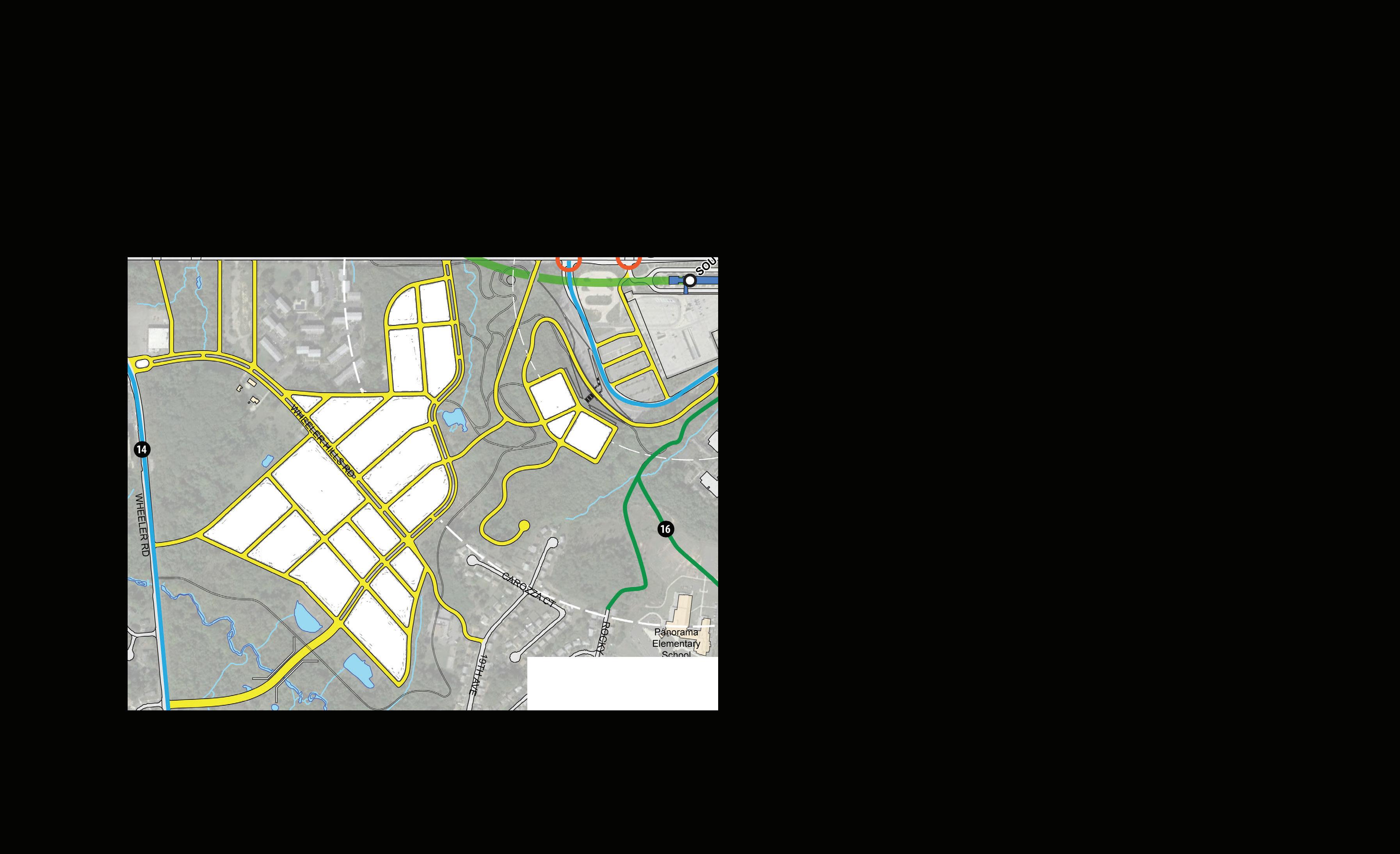
Sector Plan Area Boundary
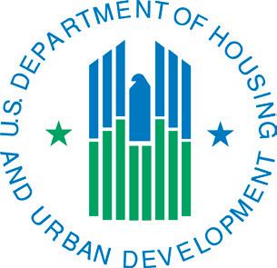
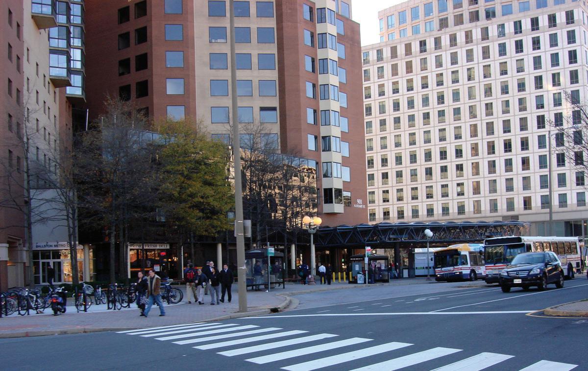
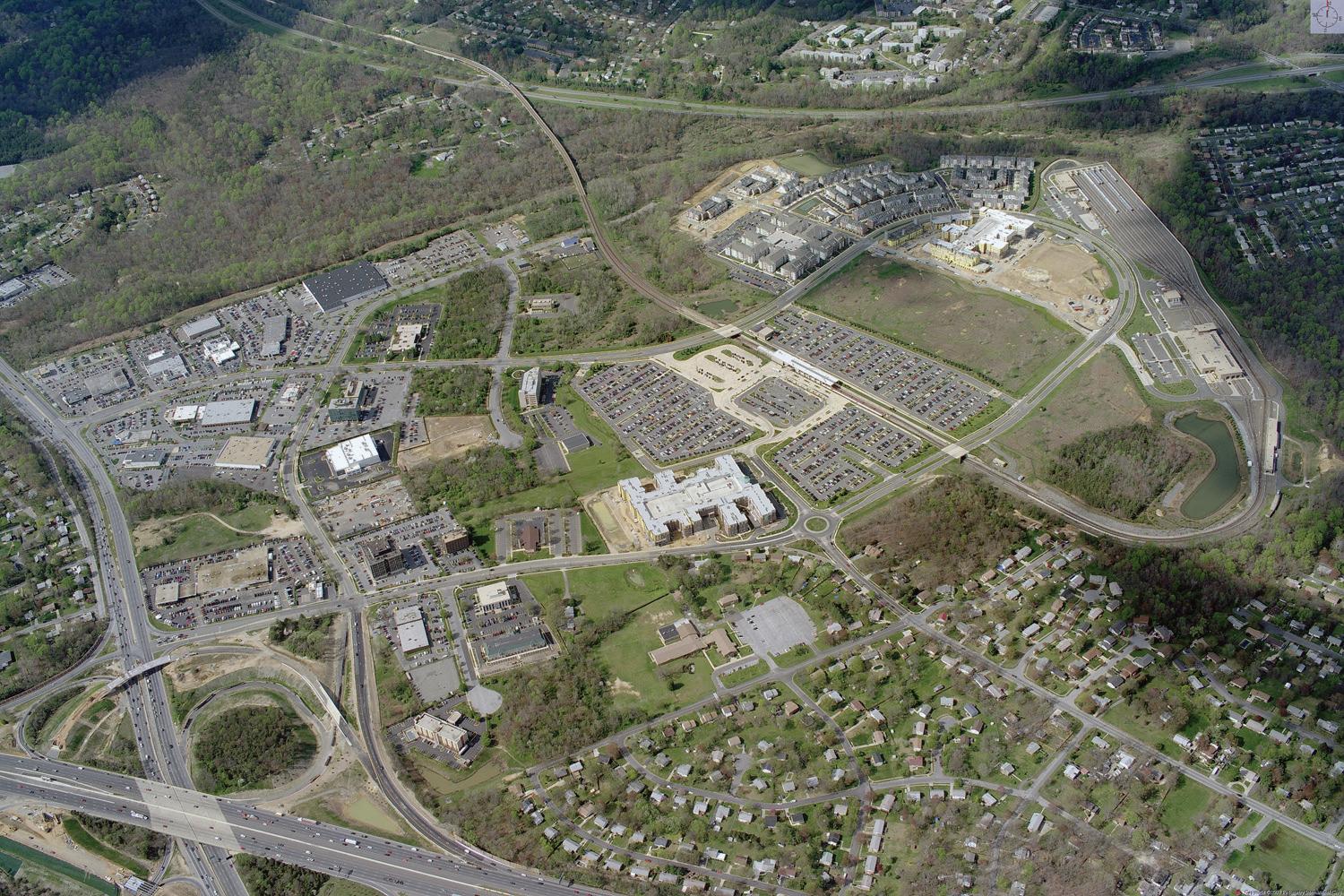
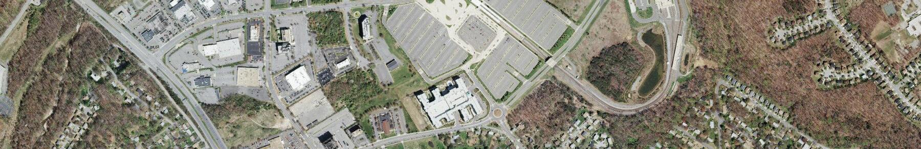
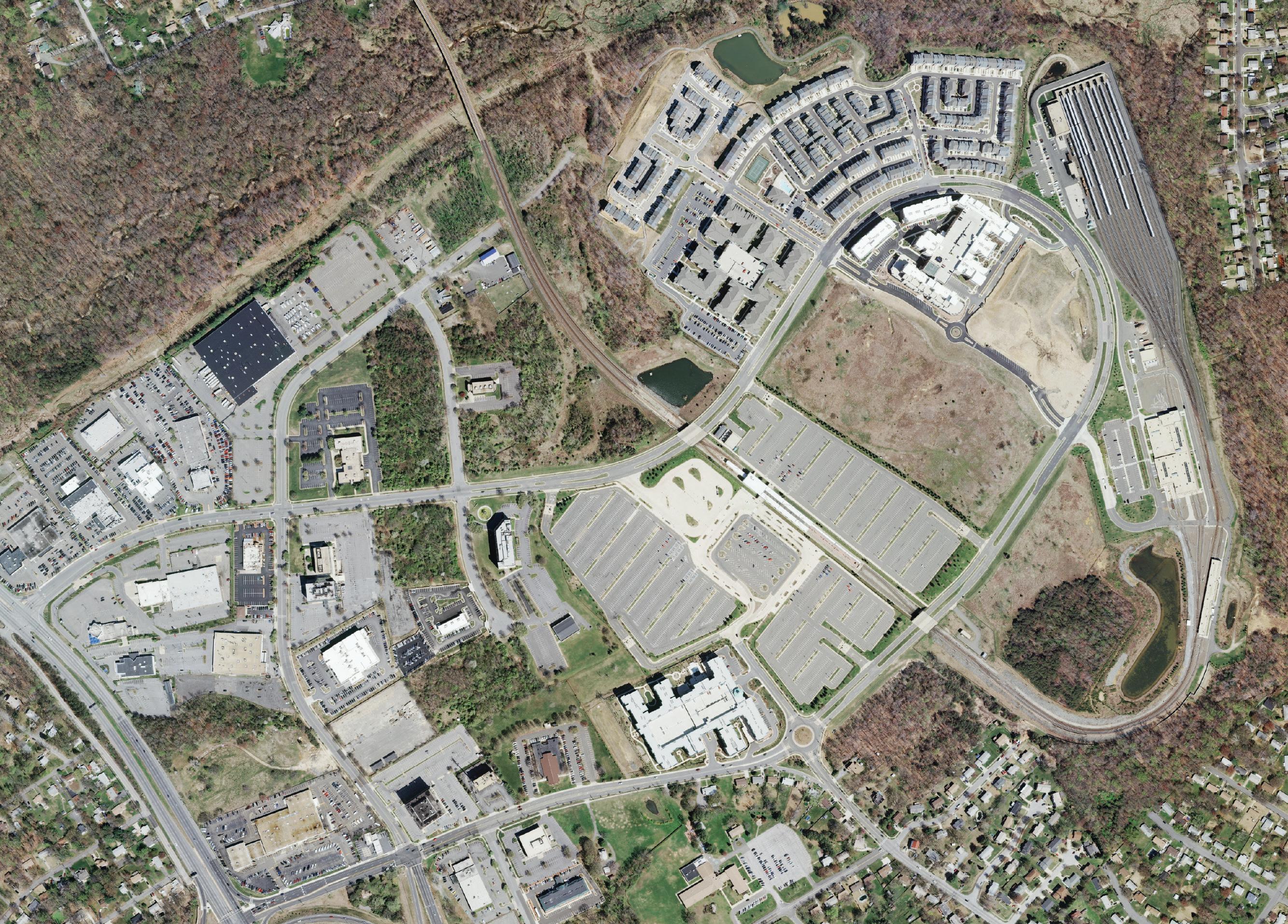
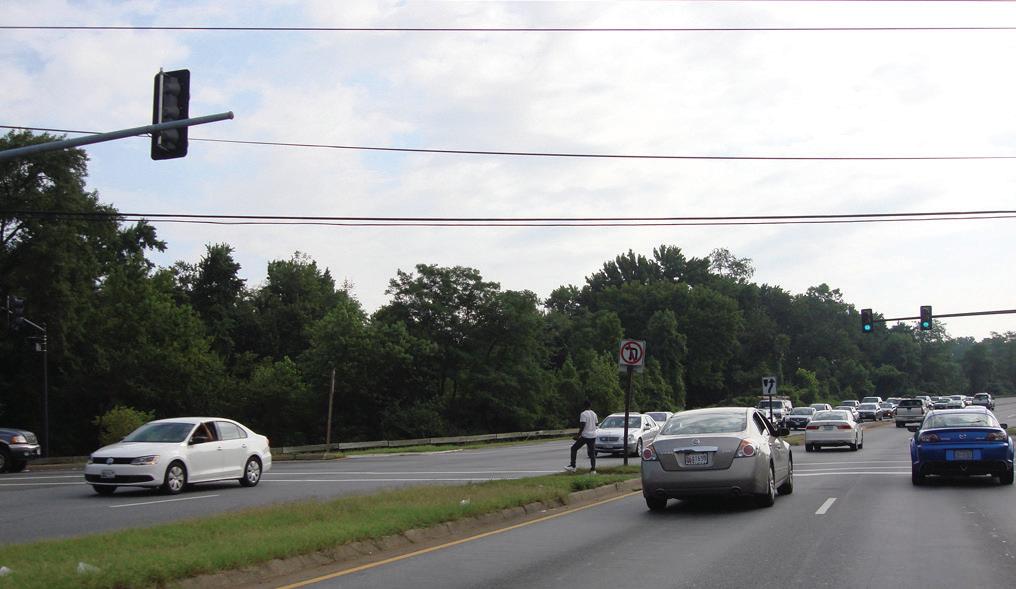
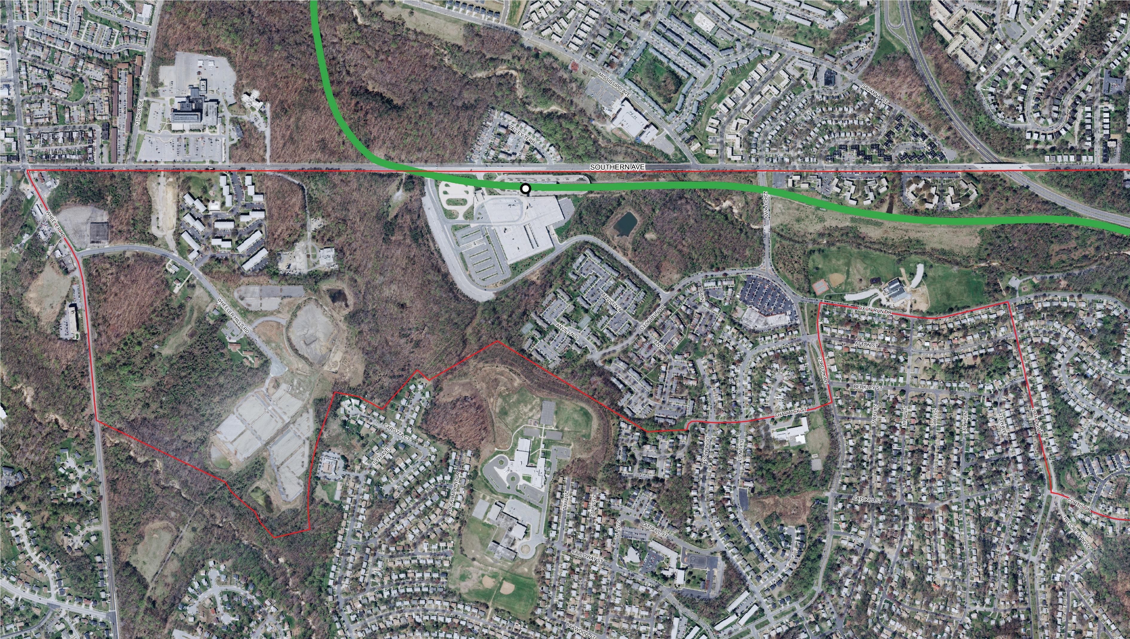
The sector plan area boundary is organized around the last four Metro stations on the Southern Green Line in southwest Prince George’s County, approximately four miles in a straight line from the Mall in the District of Columbia It is roughly bounded by Southern Avenue to the west, MD 218 (Suitland Road) to the north, MD 5 (Branch Avenue) to the south, and I-95/495 (the Capital Beltway) to the east and lies between the district line at Southern Avenue and Joint Base Andrews Naval Air Facility on Allentown Road. The area is best known by its individual neighborhoods—Suitland, Silver Hill, Camp Springs, Hillcrest Heights, and Temple Hills; all of which are unincorporated, U.S. Census-designated places. The sector plan boundary encompasses over 3,700 acres and contains approximately 25,000 residents.
The four Metro stations are:
• Southern Avenue
• Naylor Road
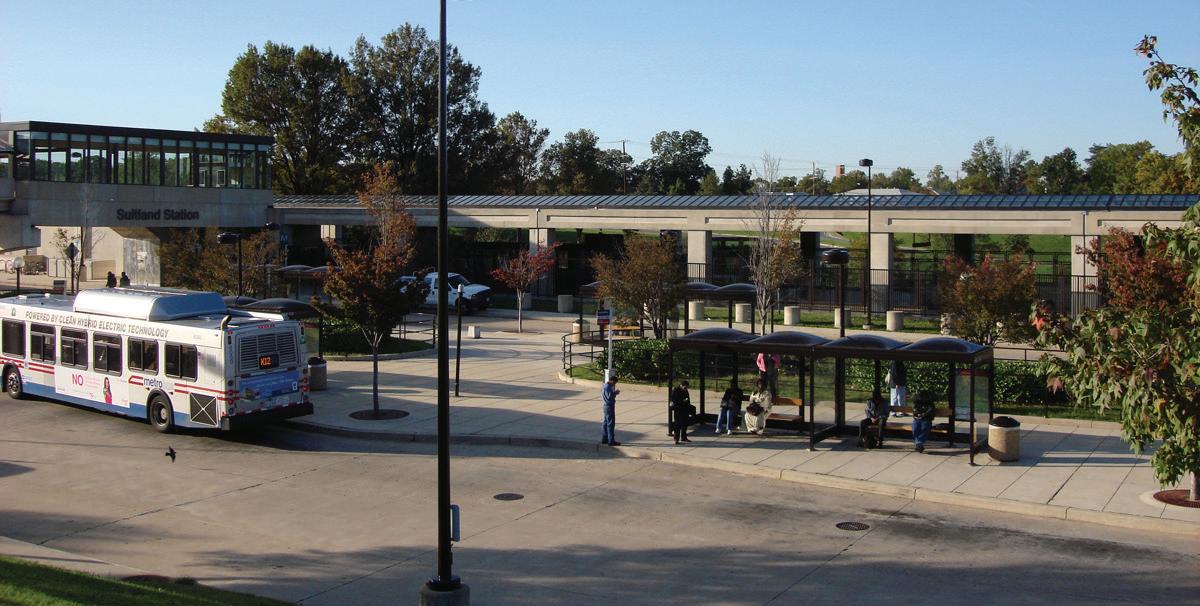
• Suitland
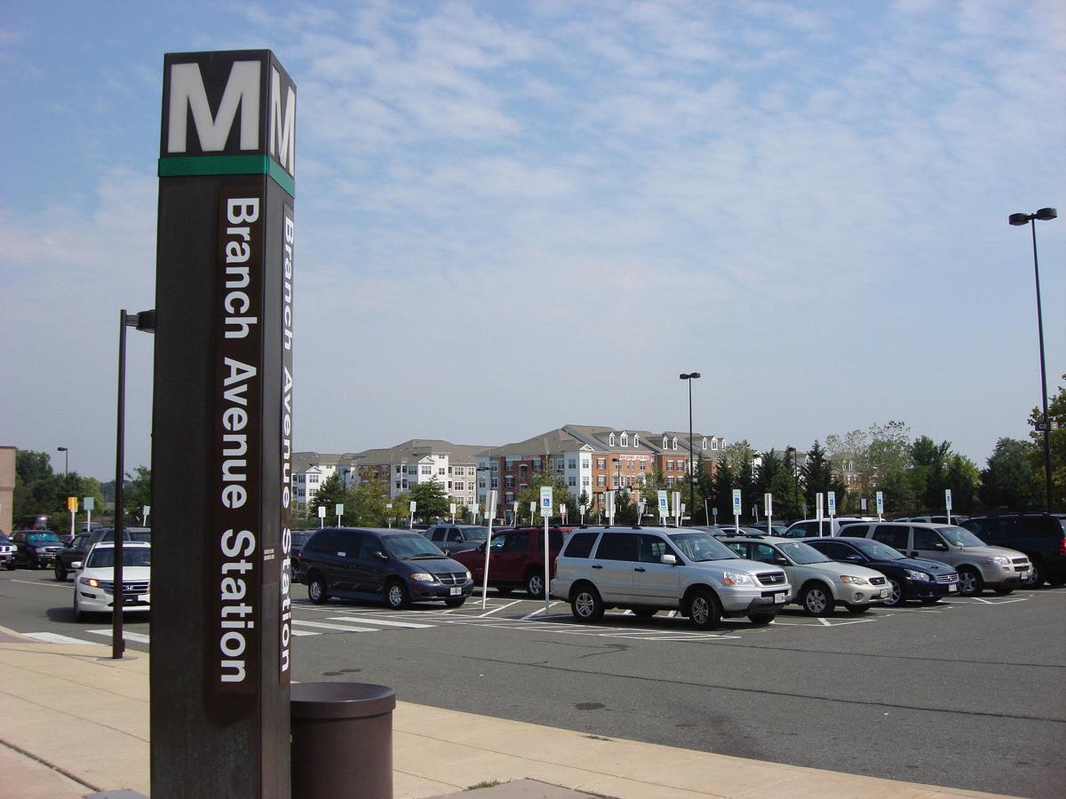
• Branch Avenue
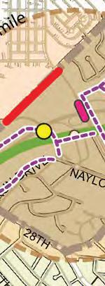
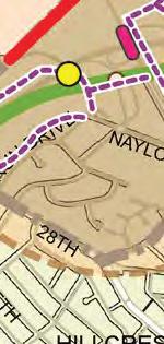
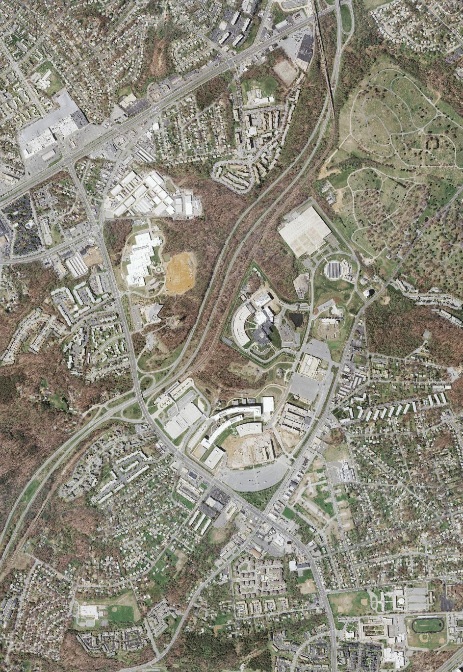
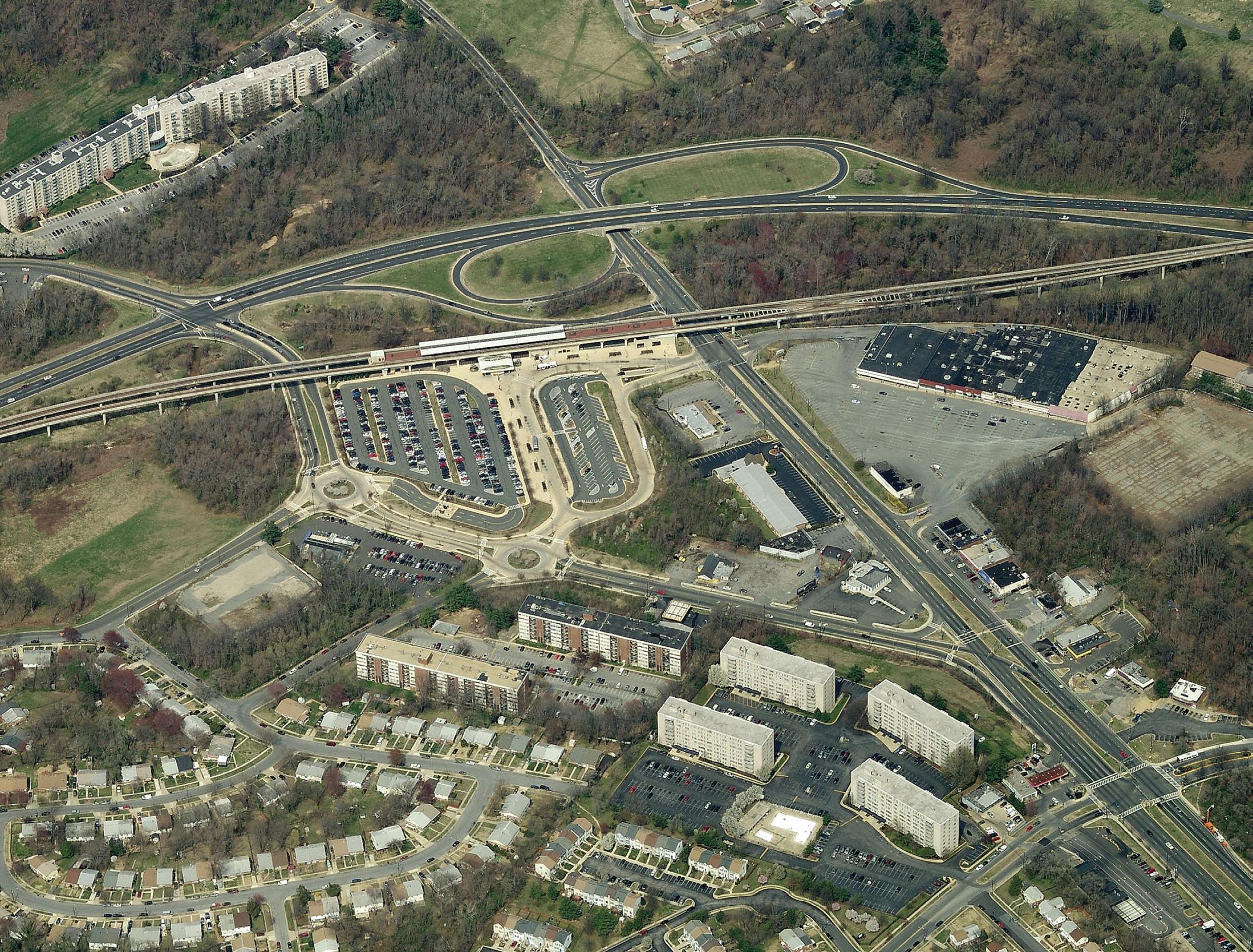
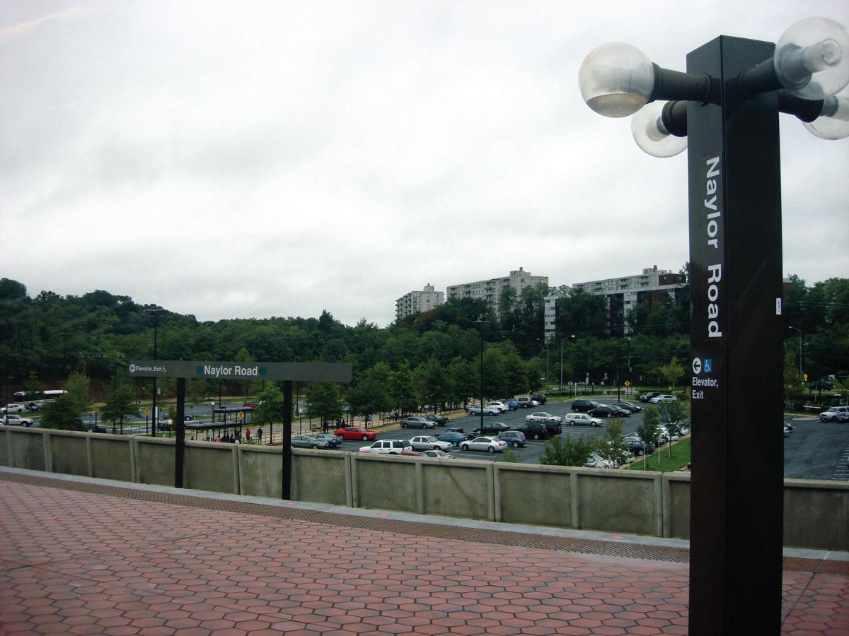
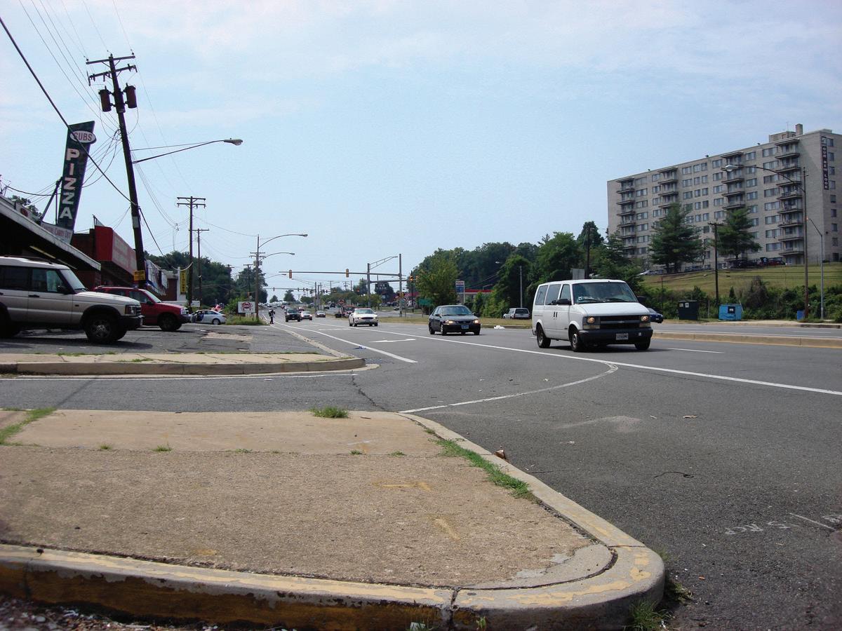
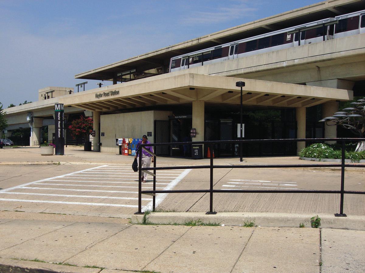
The Southern Avenue Metro Station is located on Southern Avenue just across the District of Columbia line in Prince George’s County. It lies on the western edge of the Hillcrest Heights community and is the most isolated of the four stations because of its location between the Oxon Run stream and a 100-foot bluff west of the station. The Naylor Road Metro Station
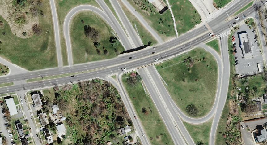
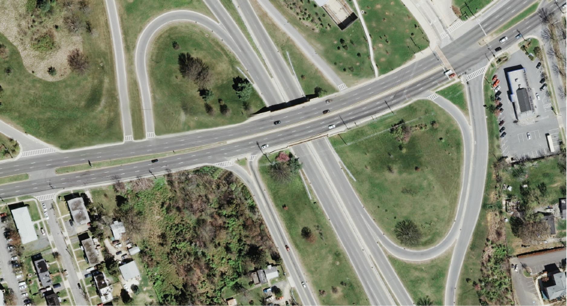
sits between Naylor Road (MD 673) and MD 5 (Branch Avenue) at Suitland Parkway, also close to the District of Columbia border. About two miles east is the Suitland Metro Station at Suitland Parkway and MD 458 (Silver Hill Road) which sits immediately west of the 240-acre Suitland Federal Center. The last station on the line, MD 5 (Branch Avenue), is one-half mile from MD 5 (Branch
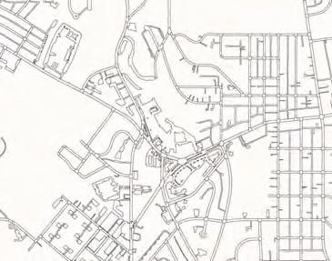
Figure 1: Regional Context
Avenue) and I-95/495 (the Capital Beltway). Developable land surrounds the station in every direction and recent residential development close to the station more appropriately defines the market for TOD. A one-half mile radius around each station roughly defines the station areas.
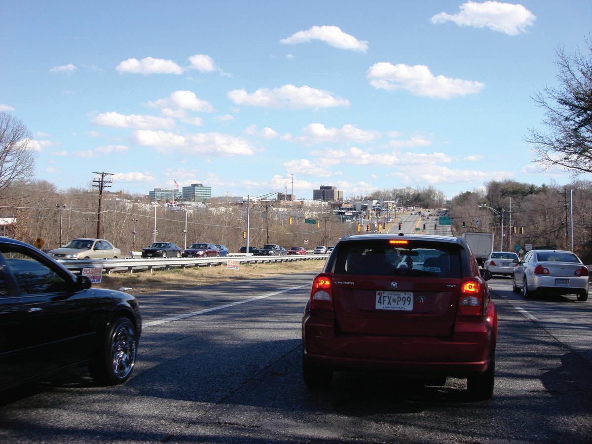
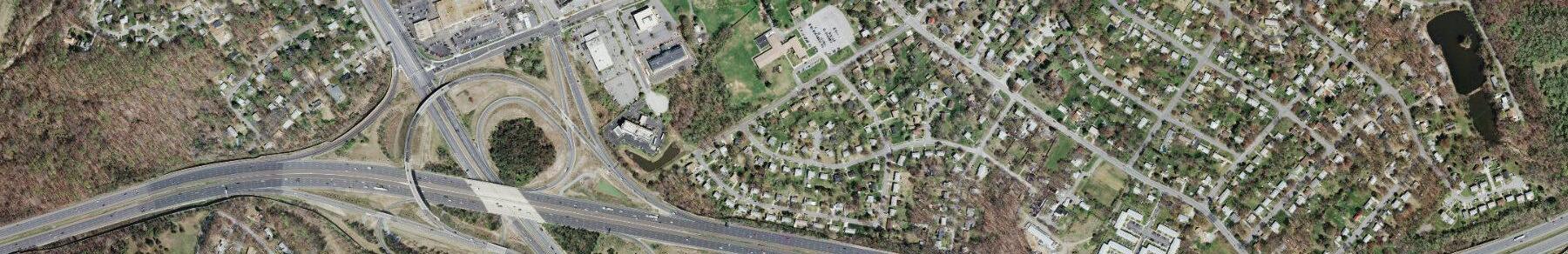
Several major transportation routes exist within and near the sector plan area. They include Suitland Parkway, MD 5 (Branch Avenue), and MD 4 (Pennsylvania Avenue), all major expressways leading into the District of Columbia, and I-95/495 (the Capital Beltway) which provides
access to the whole Washington metropolitan area.
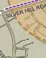
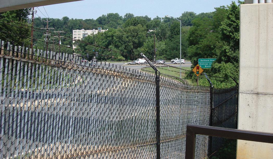
MD 458 (Silver Hill Road) is the only arterial connection between MD 4 (Pennsylvania Avenue), Suitland Parkway, and MD 5 (Branch Avenue) between Southern Avenue and I-95/495 (the Capital Beltway).
Relationship to Other Plans, Policies, and Initiatives
The 2013 Southern Green Line Station Area Sector Plan, approved on February 24, 2014, replaces the 2013 Approved Central Branch Avenue Revitalization Sector
Plan, the 2010 Approved Subregion 4 Master Plan1, the 2008 Approved Branch Avenue Corridor Sector Plan and the 2000 Approved Master Plan for the Heights and Vicinity (Planning Area 76A) for properties within this sector. The sector plan carries forward many of the policies of recent previous area master, sector, and functional master plans, in addition to the 2002 General Plan and state planning policies; the sector plan was amended October 24, 2023 by CR-103-2023 to carry forward recommendations along Suitland Road from the 2013 Approved Central Branch Avenue Corridor Revitalization Sector Plan. This sector plan, however, represents the first time that planning has occurred along the entire length of the southern Metro Green Line in Prince George’s County. Previous plans have primarily focused on individual stations and adjacent communities, thereby missing an opportunity to understand how the stations relate to and can potentially complement each other and can benefit from an integrated TOD strategy. This sector plan is informed by, but replaces these plans to reflect new policies, priorities, and strategies that relate to land use, development patterns, and urban design, zoning, transportation and other public facility improvements, and parks and recreation facilities. These planning efforts are organized below in their respective categories including master plans, sector plans, and related studies; countywide plans; and state planning initiatives.
Master and Sector Plans
The following plans cover a portion of the Southern Green Line station area including one or more of the Green Line Metro stations:
The 2000 Approved Master Plan and Sectional Map
1 This master plan included goals, policies, and strategies for the growth and for the Suitland Metro Station in anticipation of a future zoning reclassification to the Community Urban Center District (UC-3) Zone that has not occurred. This regulating plan and the associated text carries forward the development concept and guidance from the 2006 Suitland Mixed-Use Town Center Development Plan.
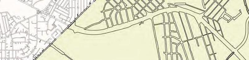
Figure 2: Planning Context
Amendment for the Heights and Vicinity predates the opening of the Southern Green Line stations and, in fact, the Naylor Road Metro Station was under construction at the time the plan was developed. The plan includes three of the four Metro stations though it addresses them within the context of the surrounding neighborhood not in relation to one another. The Suitland Metro Station is outside the boundaries of the sector plan area. The Heights plan recommends new land uses at the stations to promote development intensities that take advantage of the new transit infrastructure. With the exception of the Naylor Road Metro Station area, the plan established the zoning patterns currently in existence today. Office zoning encompasses most of the Southern Avenue Metro Station area while a mix of zoning districts permitting office, residential, commercial and mixed-use development were put in place in the Branch Avenue Metro Station area. The 2007 Branch Avenue Corridor Plan established the current zoning at the Naylor Road Metro Station. The Heights plan also predated the 2002 General Plan that later established the development tiers and Metro station classifications.
The 2008 Approved Branch Avenue Corridor Sector Plan recommends an urban mix of uses integrated with new office buildings within walking distance of the Naylor Road Metro Station. It also recommends mixed-use, medium- to high-intensity land uses with emphasis on commercial development at the Iverson Mall and Marlow Heights Shopping Center. The plan provides design concepts, standards, and guidelines to guide transit- and pedestrianoriented redevelopment in urban form. The plan’s concurrent SMA rezoned property, along the MD 5 (Branch Avenue) corridor from Naylor Road Metro Station to Marlow Heights Shopping Center, to Mixed Use-Transportation Oriented (M-X-T) and a 20-acre parcel, at the southwestern quadrant of the intersection of MD 458 (Silver Hill Road) and Suitland Parkway, from Multifamily Medium Density Residential (R-18) to Multifamily High Density Residential (R-10).
The 2013 Central Branch Avenue (CBA) Corridor Revitalization Sector Plan (CBA Sector Plan) includes the Branch Avenue Metro Station area within its boundaries but acknowledges that this area is the subject of the Southern Green Line Station Area Sector Plan. The CBA plan focuses on communities along the MD 5 (Branch Avenue) corridor between the station and Southern Maryland Hospital and recognizes the station area as a major development opportunity along the corridor. In its adoption of CR-10-2012 on March 20, 2012, the District Council initiated the Southern Green Line Station Area Sector Plan for portions of Planning Area 76A covered by the then-underway CBA Sector Plan. The CBA Sector Plan was approved on April 2, 2013 (CR-24-2013), covering portions of the Southern Green Line Sector. The Southern Green Line Station Area Sector Plan, upon its approval on February 25, 2014, replaced the CBA Sector Plan as the applicable area master plan within Planning Area 76A.
Related Studies
The 2006 Suitland Mixed-Use Town Center (M-U-TC) Development Plan presents a land use concept for a town center in Suitland including new retail, office, and residential uses at a development intensity appropriate for a Metro station location. The boundaries include the Suitland Metro Station and the adjacent community. The plan established the Mixed-Use Town Center zone (M-U-TC) to implement the development plan for the area. The zone permits land use flexibility and provides unique design standards and guidelines for commercial and residential development consistent with the plan. The district has its own byright development review process that involves a local development review committee and Planning Department administrative signoff of development applications that are in conformance with these standards and guidelines. This sector plan encompasses the entire Suitland Mixed-Use Town Center (M-U-TC) area within its boundaries but leaves the Mixed-Use Town Center (M-U-TC) zone in place.
Other planning initiatives and studies that directly affect the Southern Green Line sector plan area include:
• The 2010 Branch Avenue Station Access and Joint Development Study completed by Washington Metropolitan Area Transit Authority (WMATA). The study includes a development concept for the 33-acre WMATA station site and identifies station access and facility improvements needed to ensure efficient operation of the transit facility as the area builds out.
• The 2011 Naylor Road Metro Station Area Accessibility Study identifies hindrances to pedestrian accessibility and provides recommendations for improvement and associated costs for improvement options.
• The 2012 Naylor Road Metro Station Access and Capacity Study identifies access and facility improvements needed to efficiently operate the transit facility based on the CBA Corridor Revitalization Sector Plan projected build-out estimates.
Countywide Plans
Several countywide plans, including the 2002 Approved General Plan, establish policies and recommendations for future growth and development in the County. These plans informed the Southern Green Line planning process.
The 2002 Approved General Plan sets forth goals, objectives, policies, and strategies for the County. It divides the County into three growth policy tiers: Developed Tier, Developing Tier, and Rural Tier to distinguish different development patterns and the form and intensity of development. These policy areas designate areas of significant economic development, residential development, and preservation. The Developed Tier includes communities within I-95/495
(the Capital Beltway) including all four Southern Green Line station areas. The Developed Tier contains more than half of the County’s households and nearly half the employment. The General Plan vision for the Developed Tier is a network of sustainable, transit-supporting, mixed-use, pedestrian-oriented, medium- to high-density communities. Policies for the Developed Tier emphasize quality infill and redevelopment, provision of adequate public facilities to serve existing and future residents, as well as preservation and enhancement of the environment.
The general plan also targets growth to a number of designated centers classified as Metropolitan, Regional, or Community Centers. These centers capitalize on existing infrastructure by locating dwellings, jobs, and shopping centers closer to transit. The Southern Avenue Metro Station area is designated a Community Center which is envisioned as having concentrations of activities, services, and land uses that serve the immediate neighborhoods. The Naylor Road and Suitland Metro Station areas are both designated Regional Centers. Regional Centers are locations for regionally marketed retail destinations, office and employment areas, higher-education facilities, and possibly sports and recreational complexes. High-density residential development may be an option if the needed public facilities and services can be provided.
The Branch Avenue Metro Station is designated a Metropolitan Center which is the highest-intensity development classification in the general plan. Perhaps the best existing example in the County of the type of development sought at a Metropolitan Center is National Harbor, with plans for other areas such as New Carrollton also moving into implementation as a designated Metropolitan Center. These Metropolitan Centers are to have a concentration of economic activities that attract employers, workers, and customers from other parts of the District of Columbia metropolitan area, such as
RAIL~VOLUTION
State Planning Policy
The Maryland General Assembly enacted the 1992 Maryland Economic Growth, Resource Protection and Planning Act to encourage economic growth, limit sprawl, and protect the state’s natural resources. The act establishes over-arching land use policies to be locally implemented statewide.
These policies are stated in the form of eight visions. The 1992 Maryland Planning Act was updated with the passage of the 2009 Smart and Sustainable Growth Act.
large government offices and major private-sector employers, major educational complexes, or highintensity commercial uses. High-density residential development may also be located at a Metropolitan Center.
The 1997 Smart Growth and Neighborhood Conservation Act builds on the foundation of the eight visions adopted in the 1992 Maryland Economic Growth, Resource Protection and Planning Act, as amended. The 1997 act is nationally recognized as an effective means of evaluating and implementing statewide programs to guide growth and development. The Maryland smart growth program has three goals:
1. To save valuable remaining natural resources.
2. To support existing communities and neighborhoods.
This sector plan amends the 2002 General Plan and the 2009 Approved Countywide Master Plan of Transportation, reflecting new policies and implementation strategies to achieve the community vision for the future of the Southern Green Line. 2
2 Subsequent to approval of this sector plan but prior to its publication, the District Council adopted CR-26-2014, approving Plan Prince George’s 2035 (Plan 2035), a new General Plan for Prince George’s County. Plan 2035 designates the Branch Avenue and Suitland Metro Station areas as Regional Transit Districts, the Naylor Road Metro Station area as a Local Transit Center, and the Southern Avenue Metro Station area as a Neighborhood Center.
3. To save taxpayers millions of dollars in unnecessary costs for building infrastructure to support sprawl. A significant aspect of the initiative is the smart growth areas legislation that requires that state funding for projects in Maryland municipalities, other existing communities, industrial, and planned growth areas designated by counties will receive priority funding over other projects. These smart growth areas are called Priority Funding Areas (PFA). The entirety of the sector plan location is within the Targeted Growth and Revitalization area as shown on the County’s Plan Maryland Designated Places map and is designated a PFA by the County and the state. The sector plan recommends a phasing plan and identifies additional tools for implementation to take full advantage of the PFA designation.
PLANNING Action
The 2009 Smart and Sustainable Growth Act clarifies the link between local comprehensive plans and local land use ordinances. The bill reinforces the importance of planning for sustainable growth and development in all local jurisdictions within the state. The eight plan visions stated in the 1992 Maryland Planning Act were replaced with an updated and expanded list of 12 visions:
1. A high quality of life is achieved through universal stewardship of the land, water, and air resulting in sustainable communities and protection of the environment.
2. Citizens are active partners in the planning and implementation of community initiatives and are sensitive to their responsibilities in achieving community goals.
7. Economic development and natural resource-based businesses that promote employment opportunities for all income levels within the capacity of the state’s natural resources, public services, and public facilities are encouraged.
8. Land and water resources, including the Chesapeake and coastal bays, are carefully managed to restore and maintain healthy air and water, natural systems, and living resources.
9. Waterways, forests, agricultural areas, open space, natural systems, and scenic areas are conserved.
10. Government, business entities, and residents are responsible for the creation of sustainable communities by collaborating to balance efficient growth with resource protection.
Great communities are being built along the Green Line. Help shape the next great places at Southern, Naylor Road, Suitland and Branch Avenue Metro Stations.
3. Growth is concentrated in existing population and business centers, growth areas adjacent to these centers, or strategically selected new centers.
4. Compact, mixed-use, walkable design consistent with existing community character and located near available or planned transit options is encouraged to ensure efficient use of land and transportation resources; preservation and enhancement of natural systems, open spaces, recreational areas; and historical, cultural, and archeological resources.
5. Growth areas have the water resources and infrastructure to accommodate population and business expansion in an orderly, efficient, and environmentally sustainable manner.
6. A well-maintained, multimodal transportation system facilitates the safe, convenient, affordable, and efficient movement of people, goods, and services within and between population and business centers. A range of housing densities, types, and sizes provides residential options for citizens of all ages and incomes.
11. Strategies, policies, programs, and funding for growth and development, resource conservation, infrastructure, and transportation are integrated across the local, regional, state, and interstate levels to achieve these visions.
Together, the twelve visions provide guiding principles that describe how and where growth can best occur without compromising the state’s natural and cultural resources. The act acknowledges that the comprehensive plans prepared by counties and municipalities form the best mechanism to establish priorities for growth and resource conservation. Once priorities are established, it is the state’s responsibility to support them.
Join us and have your voice heard.
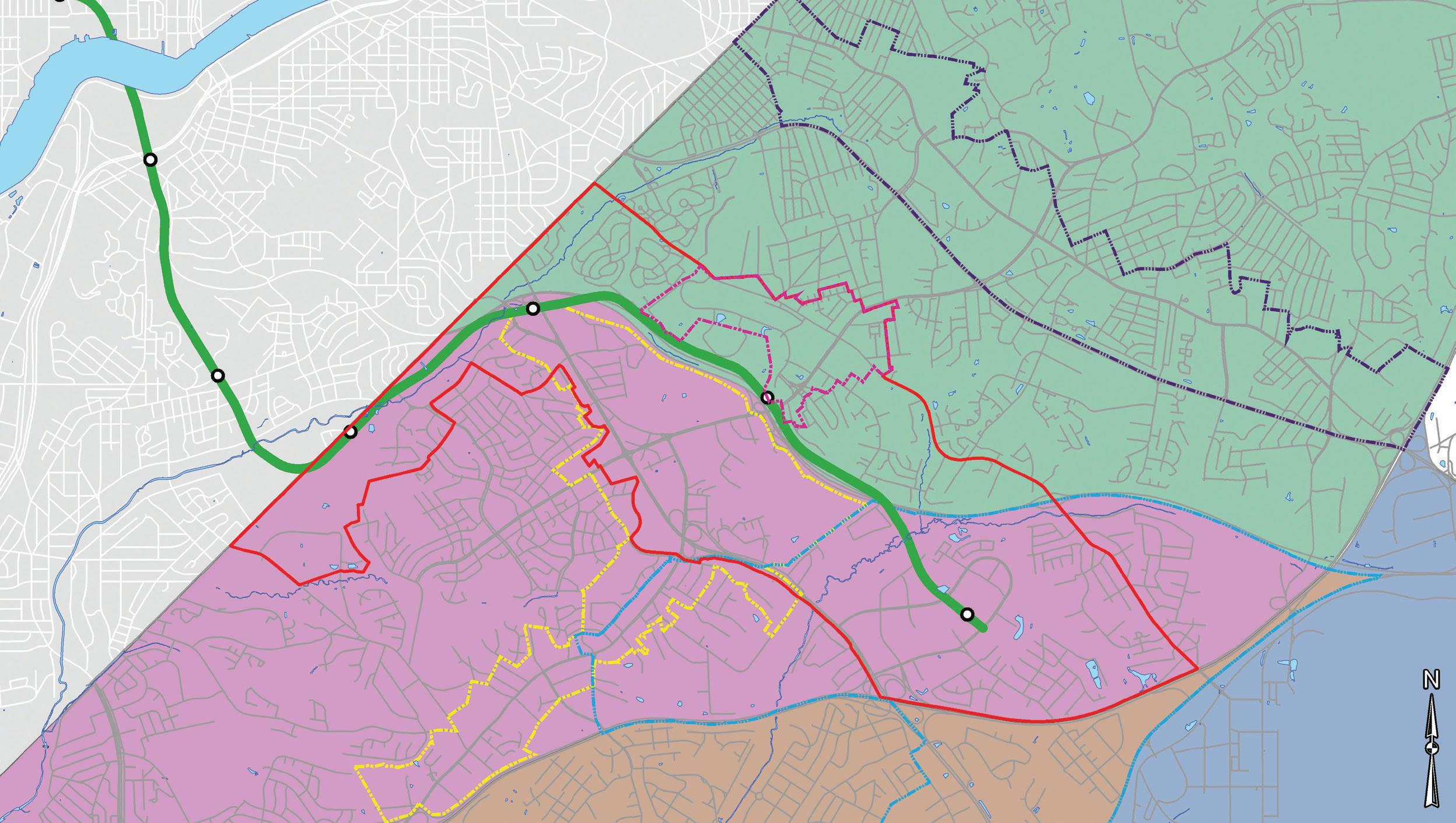
An aerial photograph from 1938 shows the rural character of southern Prince George’s County. The bright white to grey areas are generally cultivated fields, showing the small-scale agricultural use of the land going back to the first settlement by Europeans. The impediments to agriculture are also shown in the darker areas that are steep slopes with trees and stream valleys. A large forested area is shown to the south of the sector plan area. MD 458 (Silver Hill Road) can be seen with a concentration of fields and other uses and a hamlet at the crossroad with MD 218 (Suitland Road), this being the Suitland community.
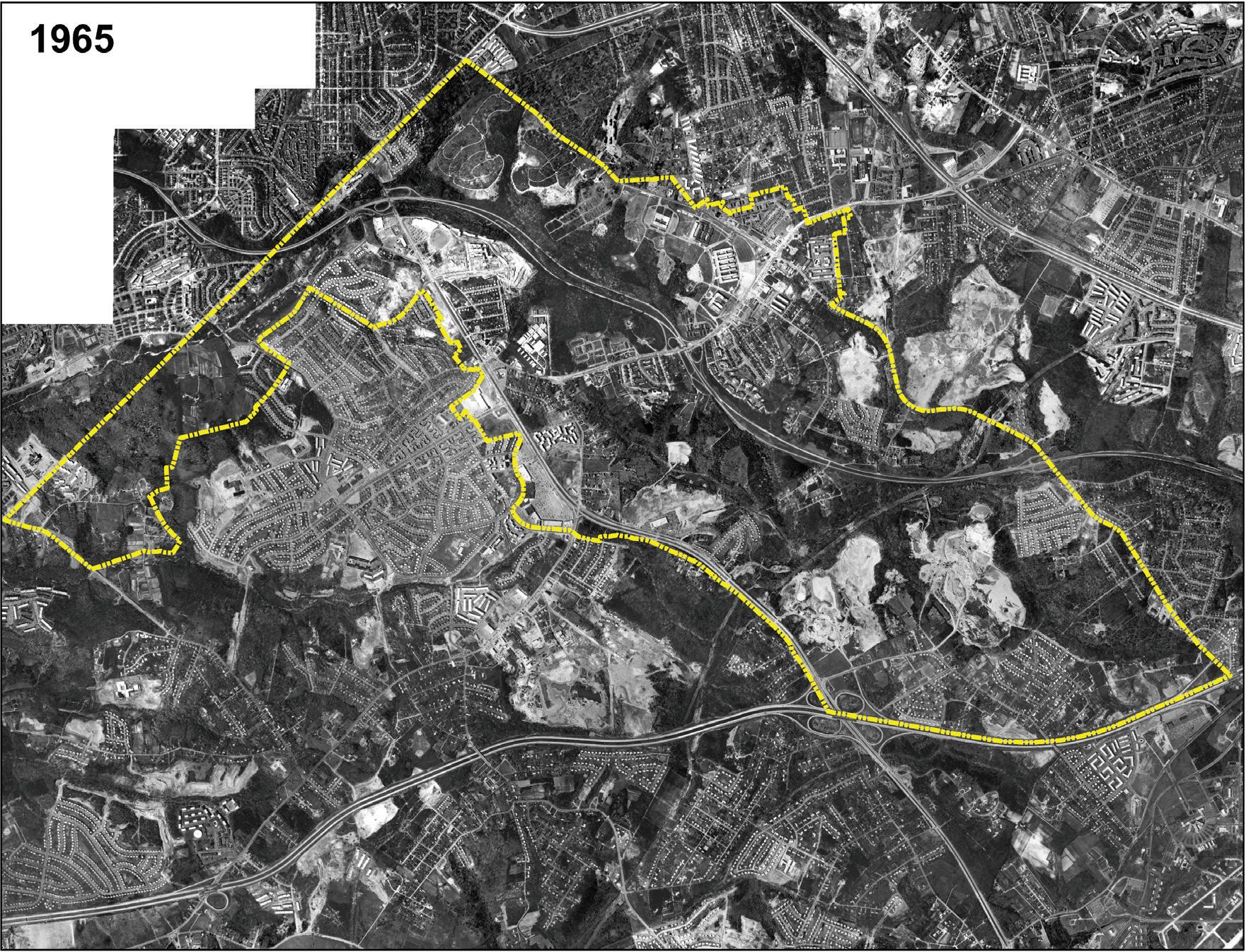
Only 30 years later the area was almost wholly suburban in character. Massive roadway projects, including the I-95/495 (the Capital Beltway), Suitland Parkway and MD 5 (Branch Avenue) have been completed. Agricultural uses have all but vanished, replaced by subdivisions and the gravel mines providing the material for construction. The Hillcrest Heights neighborhood, where a large forest had stood in 1938, can be seen center left. The U.S. Census Bureau buildings can be seen at Suitland, center right.
Plan Boundary
Plan Boundary
Figure 3: Historic Aerial Photographs
Supplemental Documents
The planning process for this sector plan involved the preparation of several supplemental documents that informed the plan goals, vision, and strategies; and provided more in-depth information and analysis of key issues. The list of supplemental documents includes the following:
• Urban Land Institute Technical Assistance Panel Report (ULI TAP) (August 2011)
• Southern Green Line Station Area Plan Market Study and Action Plan, Prince George’s County (November 2012)
• Southern Green Line Station Area Plan Existing Conditions Report (2013)
• Southern Green Line Station Area Plan, Transportation Access and Mobility Report (March 2013)
• Southern Green Line Station Area Plan Urban Design Report (May 2013)
Community Participation
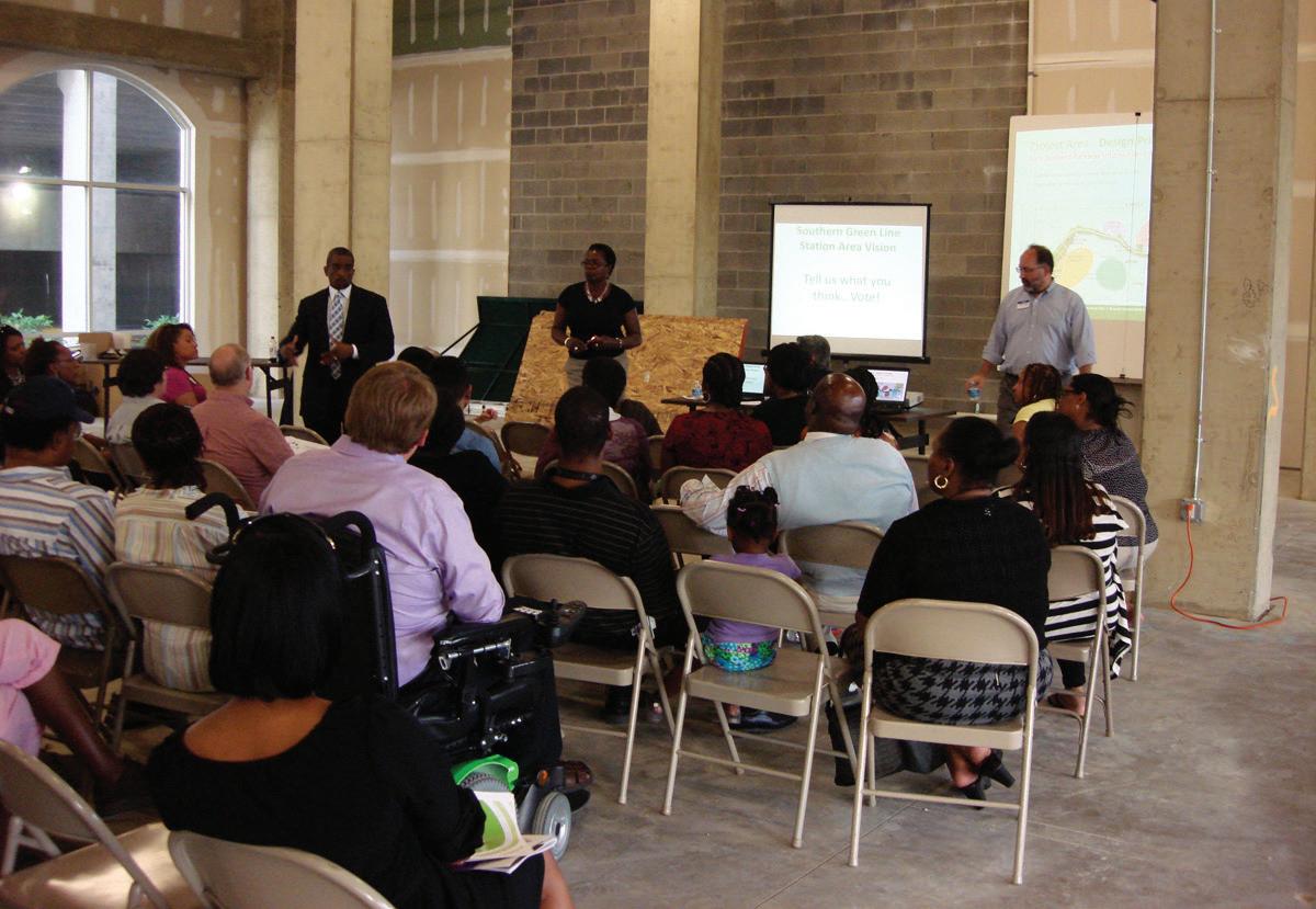
The 2014 Approved Southern Green Line Station Area Sector Plan is the result of an extensive outreach and engagement strategy for a diverse group of key stakeholders and community members. The approach was fundamental to identifying issues and concerns and generating feedback on plan recommendations. Sustained participation by stakeholders is critical to the success of this plan. Plan implementation will require stakeholders to be advocates for and stewards of the plan during its creation but also well beyond approval. The goals for community participation were to:
• Inform and educate residents about transit-oriented development (TOD) and the opportunities that exist in the sector plan area;
• Ensure that all members of the community had an
equal chance and multiple opportunities to engage in the planning process, and provide input and feedback on plan recommendations;
• Provide support for long-term, community-based advocacy for implementing the plan elements; and
• Identify resources and partnerships for implementation.
Below is a summary of the community engagement methods used during the planning process.
Urban Land Institute (ULI) of Washington’s Technical Assistance Panel (TAP):
One of the first public outreach initiatives for the Southern Green Line Station Area sector plan was the use of the Urban Land Institute (ULI) of Washington’s Technical Assistance Panel (TAP). ULI TAP was used to identify issues, opportunities, and an overall strategy for bringing development to the Southern Green Line sector plan area. The ULI TAP provides expert, multidisciplinary advice on land use and real estate issues facing public agencies and nonprofit organizations in the Washington, D.C. metropolitan area. Understanding the regional economic position of the sector plan area and suggesting strategies for future economic development was crucial to the Southern Green Line station area sector plan project. The ULI panel held a two-day workshop to collect and analyze data on the sector plan area and make preliminary recommendations on development strategies to community leaders and other key stakeholders. These recommendations were included in a final report for use in the planning process.
Rail~Volution Conference: Rail~Volution, a national organization promoting rail transit and TOD, hosted its annual conference in Washington, D.C. in October 2011 and selected the Suitland community for a mobile workshop and charrette. Conference attendees and community members, including public agencies, met
in Suitland in a day-long session to discuss issues and design concepts. Community members embraced concepts developed in the workshop, which were then presented to a panel of developers at the conference.
Technical Advisory Committee: The creation of a technical advisory committee provided an opportunity to engage technical staff from County, state, and regional government agencies during the planning process to identify issues, generate and test recommendations, and reach consensus on a course of action. The technical advisory committee participated in a two-day charrette for its input on preliminary development concepts including related public improvements and available resources.
Steering Committee: A steering committee of senior staff representing local, state, federal and regional governments, and nonprofit organizations involved in TOD was established in order to identify programs and activities affecting development along the Green Line and create an environment for interagency coordination and collaboration. The following organizations were represented on the committee:
• Prince George’s County Office of the County Executive and County agencies including the Departments of Housing and Community Development (DHCD), Public Works and Transportation (DPW&T), Economic Development Corporation (EDC), Revenue Authority, and Redevelopment Authority
• Prince George’s County Public Schools (PGCPS)
• The Maryland-National Capital Park and Planning Commission (M-NCPPC)
• Maryland Departments of Business and Economic Development, Transportation (MDOT), and Housing and Community Development (DHCD)
• United States General Services Administration (GSA)
Stakeholder Interviews: Interviews included key community stakeholders and developers in the sector plan area and greater The National Capital region. They were interviewed in a series of one-on-one meetings for their candid input on opportunities and challenges facing the corridor. Some of the community organizations represented included the Auth Village Civic Association, Branch Avenue in Bloom, Fleischman’s Village Civic Association, Hillcrest-Marlow Heights Civic Association, Hunter Memorial Church, Town Center at Camp Springs Homeowners Association (HOA), and Suitland Civic Association.
Plan Organization
This sector plan is organized into eight chapters.
• United States Department of Housing and Urban Development (HUD)
• Coalition for Smarter Growth
• Urban Land Institute (ULI) of Washington
• Washington Metropolitan Area Transit Authority (WMATA)
• District of Columbia Office of Planning
The steering committee met periodically over an 18 month period for its reaction to recommendations and approaches for meeting project objectives and to define the role that individual member organizations might play in plan implementation.
Community Meetings: A series of public meetings and workshops were held throughout the process to engage stakeholders. These meetings provided a forum to educate stakeholders on the goals of the project, provide examples of and discuss successful TOD, identify community concerns, and solicit input and feedback on different issues, ideas, and recommendations for the sector plan area and the areas around each Metro station. Meeting planners used electronic polling to measure support for key recommendations and gather select demographic information from stakeholders. This approach provided immediate feedback; distinct preferences were found among different demographic groups.
Southern Green Line Coalition: A coalition of community organizations and interested stakeholders formed during the development of the plan to advocate for implementation of the approved sector plan as well as serve as a voice for the sector plan area.
Chapter 1: Includes the foregoing introduction and discussion of the plan purpose and impetus, sector plan area boundary, planning context including relationship to recent plans, policies and statewide planning initiatives, and supplemental documents. This chapter also includes a discussion of community participation in the development of the sector plan and concludes with a review of the history of the sector plan area.
Chapter 2: Summarizes existing conditions and key findings for the sector plan area as a whole and identifies plan goals and the vision for the area including specific policies pertaining to land use and zoning, transportation and other public facility improvements.
Chapters Provide for each station area an existing condition summary, a detailed description of the station area’s typology and vision, and a development program along with concepts, illustrative plans, and key land use, zoning, and transportation policies.
Chapter 7: Presents the implementation plan that summarizes key policies, strategies, and priorities, and identifies agency roles and responsibilities. It summarizes this information within a matrix for easy reference and use.
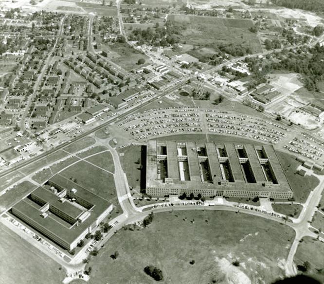
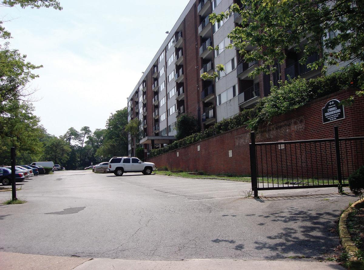
Post-1941 photo of Suitland looking east and showing the original U.S. Census Bureau and Suitland Manor apartment buildings. This area was redeveloped over the period 1993-2009; the buildings seen here are no longer extant.
3–6:
Sector Plan Area History and Development
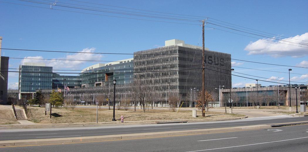
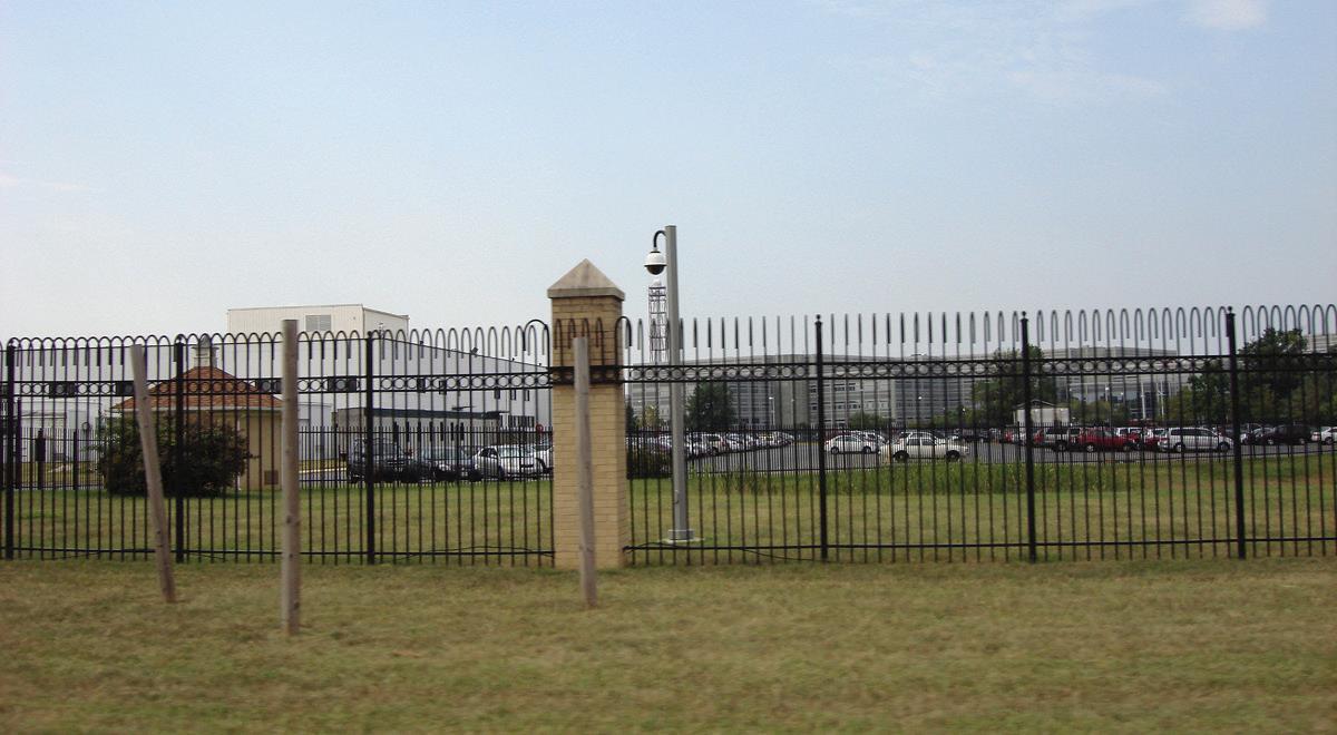
Prior to World War II, southern Prince George’s County was primarily an agricultural area that specialized in the cultivation of tobacco, a major cash crop. In the sector plan area, small truck farms grew a variety of produce for the District of Columbia, located only a few miles away. Beginning in 1941, the construction of the Suitland Federal Center at the intersection of MD 458 (Silver Hill Road) and MD 218 (Suitland Road)s brought a the first large office development to the sector plan area. The relocation of the Census Bureau out of downtown Washington, D.C., established a major federal presence in this part of the County on 437 acres of land bought by the government on both sides of the new parkway along the north side of MD 458 (Silver Hill Road). Rapid change to the landscape began during World War II when the War Department moved quickly to construct the Fighter Command Station Access Parkway, later renamed Suitland Parkway in 1944, from Bolling Air Force Base to the Camp Springs Military Reservation, later renamed Andrews Air Force Base and currently named Joint Base Andrews. This road also made the connection to the new federal campus at Suitland where the U.S. Census Bureau constructed its headquarters.
Following World War II, the agrarian landscape gave way to rapid suburban development, supported by large roadway projects such as MD 5 (Branch Avenue) and I-95/495 (the Capital Beltway). While much of the suburbanization occurred in a piecemeal fashion, one subdivision at a time, the large community of Hillcrest Heights, was planned and constructed in the 1950s and 1960s. The automobile suburb incorporated a separation of land uses, which included large swaths of ranch dwellings and duplexes, and a commercial shopping center area at the intersection of MD 5 (Branch Avenue) and Iverson Street. Iverson Mall was the anchor of the commercial center, opening as the first indoor shopping mall in the Washington, D.C. metropolitan area in 1967.
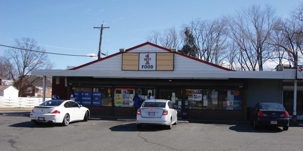
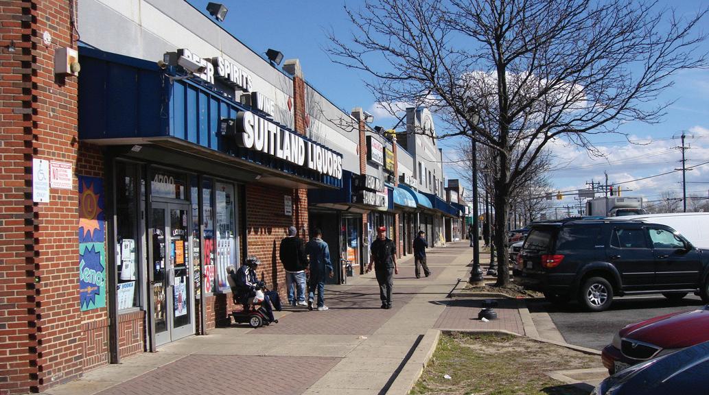
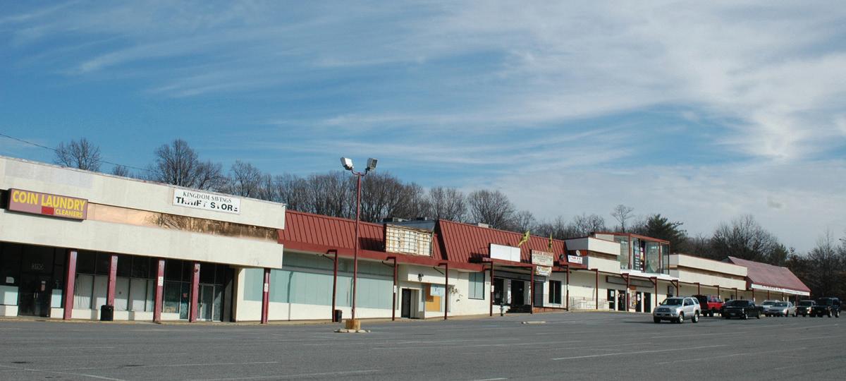
This new style of commercial development, located at a key intersection along a new modern highway, stood in contrast to the smaller retail buildings along MD 458 (Silver Hill Road) in Suitland. Incrementally, this area, once described as a rural village, came to be dominated by new auto-centric, strip shopping centers.
The area to the west of the parkway was transferred to the Smithsonian Institution beginning in 1951, with additional land transferred to the Silver Hill Volunteer Fire Department (3900 Old Silver Hill Road) and the State Roads Commission for widening MD 458 (Silver Hill Road) in 1964. The Smithsonian developed their land for storage and office facilities. This is separate from the Suitland Federal Campus that occupies 226 acres of land to the east of the parkway up to MD 218 (Suitland Road). The area to the west of the parkway was transferred to the Smithsonian Institution beginning in 1951, with additional land transferred to the Silver Hill Volunteer Fire Department (3900 Old Silver Hill Road) and the State Roads Commission for the widening of MD 458 (Silver Hill Road) in 1964. The Smithsonian Institution developed their land for storage and office facilities. This is separate from the Suitland Federal Center that occupies 226 acres of land to the east of the parkway up to MD 218 (Suitland Road). Over the decades the federal campus has also developed to include a variety of federal agencies, with facilities for Naval Maritime Intelligence, the National Archives, and the National Oceanic and Atmospheric Administration (NOAA).
A new NOAA Satellite Operations Facility Building was completed in 2005. The U.S. Census Bureau’s website explains the deteriorating relationship with the surrounding community by noting: “Through the mid1980s, the grounds of the Suitland Federal Center were open to the public and the entrances to FOB 3 were left unguarded. However, in the late 1980s, car thefts in the parking lot and petty theft in various offices brought about the need for enhanced security. A chain link
fence, topped with barbed wire, was erected around the perimeter of the complex, but was replaced in January 2000 by the current, more neighborhood-friendly, black wrought-iron fence.”
The design and layout of the 1.5 million-square foot U.S. Census Bureau building, which opened in 2007, also takes a defensive stance to the surrounding community. However, a master plan for the campus developed in 2002 by the General Services Administration (GSA) takes a different approach to future development with a grid of streets and blocks along MD 218 (Suitland Road) that would re-engage the campus with the Suitland community.
The Auth Road area in Camp Springs has had a variety of land uses in the post-war era, from truck farms to gravel mines, to planned industrial uses. Sand and gravel mines were scattered around the whole sector plan area, most likely in response to the large-scale road building which requires a gravel base. The mines in the Auth Road area were later replaced and a wide horseshoe-shaped road, Auth Way, was constructed in the early 1990s to allow for truck traffic to exit MD 5 (Branch Avenue) in what was recommended to be a light industrial district. However, once the Green Line alignment was settled after decades of litigation, the terminus station was constructed between the horseshoe of Auth Way and Auth Road, altering any plans to develop the area for industrial land use. Instead real estate developers sought to construct large multifamily condominium and apartment buildings within walking distance of the Metro station. The new century and the new rail line brought the era of transit-oriented development (TOD) to southern Prince George’s County. The Great Recession of 2007 stalled further construction, providing a period of time for the Southern Green Line Station Area Sector Plan process to consider the best way to maximize the value of the new Metro line.
Chapter 2
Sector Plan Area Existing Conditions, TOD Goals, and Plan Overview
Introduction
Chapter Two considers the sector plan area of the Southern Green Line as a whole and provides an overview of the plan, while the following four chapters focus on each of the four station areas. The first part of this chapter presents a summary of existing conditions as found in 2011-2012, including an analysis of demographics, land use patterns, public facilities, environmental resources, and the transportation system.
Following this analysis, a summary of key findings is provided along with corresponding transit-oriented development (TOD) goal statements. These TOD goals, developed and revised during the planning process with input from key stakeholders and the public, address the identified needs, opportunities, and aspirations for the sector plan area. The planning process was guided by the goal of finding creative, context-sensitive policies and implementation projects for the four station areas.
The chapter proceeds from context and goals to the plan recommendations for the entire sector plan area. These recommendations are organized from vision, to plan elements, to policy statements with an outline that includes:
• a vision statement for the sector plan area.
• a recommendation for establishing station typologies, or development program based on the real estate market analysis and other research conducted during the planning process.
• a future land use plan for the entire sector plan area.
• a recommended zoning concept.
• an overview of major transportation projects at the
1Note: Excludes the District of Columbia (see Appendix A1 for totals including the District of Columbia)
2Note: Includes the District of Columbia
Table 1: Demographic Profile, 2010 U.S. Census
Sector Plan Area
system scale.
• a basic approach to environmental protection and sustainability.
• an approach to branding and community development.
• sector plan area policy statements.
Demographic Profile
Block data from the 2010 U.S. Census shows the population within the Southern Green Line sector plan area to be 24,585 as of April 1, 2010. Between 2000 and 2010 the total population in the area grew four percent (918 people). This was half as much growth as the County experienced during the same period (eight percent).
The sector plan area was less racially diverse than the County as a whole. Ninety percent of the residents were Black, compared to 64 percent countywide. The percentage of Hispanics in the study area (four percent) was smaller compared to the percentage of Hispanics in the County (15 percent). Racial composition changed little in the corridor between 2000 and 2010, with the exception of the Branch Avenue Metro Station area, which saw a drop in the White population from 22 percent to 10 percent. The Hispanic population grew from one percent in 2000 to four percent in 2010. The most notable growth of the Hispanic population was around the Suitland Metro Station where the population grew from two percent to eight percent.
In 2010, there were 11,231 housing units, of which 923 were vacant. The dwelling unit vacancy rate in the study area (eight percent) is comparable to Prince George’s County’s vacancy rate (seven percent) as a whole. Vacancy in the corridor in 2010 was highest within a halfmile radius of the Branch Avenue Metro Station, reflecting both the recent construction of new housing and the weak market for condominiums, many of which have been subsequently rented as apartments. A drop in the number of vacant units at Suitland from 388 in 2000 to 133 in 2010, is due to the demolition of the Suitland Manor housing project. The sector plan area showed smaller growth in
housing units (five percent) than the County (nine percent) between 2000 and 2010. Residential vacancy rates in the sector plan area declined from nine percent to eight percent during this period, while they increased in the County from five percent to seven percent.
ESRI’s 2010 demographic estimates based on 2000 census data, show that areas within the Green Line corridor (especially around Southern Avenue, Naylor Road, and Suitland Metro Stations) are falling slightly behind the County economically. The sector plan area’s estimated median household income ($54,960), per capita income ($28,562), median home value ($237,232), and percentage of persons with a professional degree or higher (six percent) were all below the County estimates. Also, the unemployment rate in the sector plan area (13 percent) was higher than the County’s.
Table 2: Existing Land Use
Land Use
Land use in the sector plan area reflects the environmental features, market response to the framework set by the major roadway network, and unique-to-the-area uses brought by institutional landowners, such as the federal government and the Washington Metropolitan Area Transit Authority (WMATA). Figure 5 and Table 2 are based on land use classifications established by the Prince George’s County Planning Department. Data in the table reflects land within the sector plan area only. Parcels that straddle the corridor boundary are included if the center of the parcel is within the boundary. Roadways are not included as a land use.
Residential uses are a third of the corridor—over 950 acres of the 3,020 acre total, or just under 32 percent. The surrounding neighborhoods are primarily bedroom suburbs, providing relatively easy access to the District of Columbia Single-family houses at a density of one-half to one DU/A (low density) comprise 11.5 percent of the corridor and one third of the residential uses. Single-family houses, both detached and duplexes (low-medium density) on smaller lots at two to three dwelling units per acre (DU/A) account for six percent of the total. Townhouses (mediumhigh density) make up just over six percent of the total, while another seven percent of the corridor is high-density residential uses, at 20 DU/A or more. The existing pattern of residential densities is favorable toward transit ridership, with medium- and high-density apartments clustered around the Naylor Road Metro Station, or on the east side of MD 458 (Silver Hill Road) near Suitland Metro Station, and including a mixed-use residential component near the Branch Avenue Metro Station. The majority of the lowdensity residential lies to the northeast and southeast of the Branch Avenue Metro Station, in subdivisions next to the I-95/I-495 (the Capital Beltway), yet other big lot subdivisions are scattered across the corridor.
The second most prevalent land use in the corridor is woodland at 18 percent. This is a high amount for an
Sector Plan Area
urbanized area, with most of the forested area located on the steep ravines and lowlands of the Oxon Run and Henson Creek streams, and a main tributary of Henson Creek south of Suitland Parkway and east of MD 458 (Silver Hill Road). Another section of large woods surrounds the Southern Avenue Metro Station. Parks and open space form another seven percent of the corridor and wetlands an additional one percent, bringing the total of lands in forest, parks, or wetlands to 26 percent of the corridor. M-NCPPC owns land in the parks and open space category, including undeveloped woodlands, but facilities such as the Hillcrest Heights Community Center, located within Oxon Run Park at 2300 Oxon Run Drive, is shown under the institutional category. The southern part of the Washington National Cemetery (4101 Suitland Road) contributes to the parks and open space total.
The Suitland Federal Center contributes the majority of land in the institutional classification, which is the third largest land use in the sector plan area. Other institutional uses include churches, temples, community centers, universities, union headquarters, and utility corridors.
The 340 acres of commercial uses include both retail and office, making up just over 11 percent of the corridor. Commercial uses present the strongest discernible pattern of uses across the corridor, with retail fronting on MD 5 (Branch Avenue) from Suitland Parkway south to MD 414 (St. Barnabas Road), and more retail clustered around MD 458 (Silver Hill Road) at MD 5 (Branch Avenue) and its intersection with MD 218 (Suitland Road). Large commercial uses south of the Branch Avenue Metro Station area are primarily car dealerships, but also include office buildings. Nearly seven percent of the sector plan area is classified as bare ground, much of it slated for future development. This includes land adjacent to the Metro station, the former Suitland Manor site located northwest of the corner of MD 458 (Silver Hill Road) and MD 218 (Suitland Road), and on the high ground south of the Southern Avenue Metro Station.
The transportation category does not include roadways, rather it is primarily WMATA-owned land at the stations, including the station platforms and shelters; large surface parking lots at Branch Avenue, Naylor Road, and Southern Avenue Metro Station; and also parking structures at Suitland and Southern Avenue Metro Stations. The fact that six percent of the corridor is devoted to WMATA facilities (primarily parking) indicates that the Southern Green Line stations are primarily commuter stations. A small amount of land is currently used for mixed-use residential, with two of the three sites located at new development north and south of the Branch Avenue Metro Station. While the space exists for retail in these new buildings, all of it is currently vacant. The corridor has practically no existing industrial uses. However, as noted earlier, the Branch Avenue Metro Station area was originally recommended and zoned for industrial use; the wide roads, large parcels, and limited connections to adjacent neighborhoods are remnants of that time before construction of the Metro.
Zoning
This section, including Figure 6, describes the existing zoning for the sector plan area as it was in 2012 during the planning process. Chapters 3-6 of this sector plan recommend changes to the zoning; several of these recommendations were implemented through the 2013 Approved Southern Green Line Station Area Sectional Map Amendment (SMA).
Residential Zones
The majority of residential land in Hillcrest Heights near the Southern Avenue and Naylor Road Metro Stations is zoned One-Family Detached Residential (R-55), that permits no more than 6.7 dwelling units per acre (DU/A). Multifamily Medium Density Residential (R-18) and Multifamily Low Density Residential (R-30) zones are clustered along Southern Avenue. These zones permit 12 to 20 DU/A in garden apartment developments.
Land to the east of Southern Avenue and south of MD 637 (Naylor Road) is zoned Townhouse (R-T) and One-Family Semidetached and Two-Family Detached Residential (R-35). These zones permit 9 to 12.44 DU/A. A cluster of Multifamily Medium Density Residential (R-18) and Multifamily High Density Residential (R-10) are located proximate to the Naylor Road and Suitland Metro Stations, allowing apartment complexes over 12 DU/A. The residential areas south and east of the Branch Avenue Metro Station are zoned One-Family Detached Residential (R-80).
Commercial Zones
Large parcels of land in the vicinity of the Southern Avenue Metro Station are zoned Commercial Office (C-O), which allows for predominantly non-retail, commercial uses, such as business, professional, and medical offices, or related administrative services. None of this land is actually used for office uses, suggesting that the zoning does not fit the market. The County’s most frequently used commercial zone, Commercial Shopping Center (C-S-C), permits most retail and service uses. This zone was applied along the majority of MD 5 (Branch Avenue), before a change to the Mixed Use-Transportation Oriented (M-X-T) zone in 2008. Automobile dealerships along MD 5 (Branch Avenue) near the I-95/I-495 (the Capital Beltway) are zoned Commercial Miscellaneous (C-M).
Mixed-Use Zones
Mixed Use-Transportation Oriented (M-X-T) zoning provides locations for a variety of residential, commercial, and employment uses by mandating that developments include at least two out of the following three use categories: retail, office/research/industrial, and dwellings/hotel/motel. The zone encourages a 24-hour environment and must be located near a major intersection, or major transit stop or station that
Figure 6: Existing Zoning, 2012
Sector Plan Area
will provide adequate transportation facilities for the anticipated traffic.
There are no restrictions in the Mixed Use-Transportation Oriented (M-X-T) zone on lot size or dwelling types, instead the regulations utilize a maximum floor area ratio (FAR) calculation. The intensity of use can be increased by granting bonuses, called an “optional method of development.” Without bonuses, the development of the site is limited to a FAR of 0.4; greater densities, up to a FAR of 8.0, are granted for additions such as theaters, enclosed pedestrian spaces, rooftop activities, and residential uses. A two-step development review process requires submittal and review of a Conceptual Site Plan (CSP) and Detailed Site Plan (DSP). Both the FAR requirements and the complexity of the approval process have created problems for transit-oriented development (TOD) development proposals.
The M-X-T zone is applied to land near the Naylor Road and Branch Avenue Metro Stations. The zone requires mixing of uses and has proved to be problematic near the Branch Avenue Metro Station, forcing the construction of commercial space in locations where there is no market, leading to empty storefronts. The M-X-T zone was identified as “the closest zoning technique available to the county to adequately implement the vision of the sector plan for mixed-use development at key locations” with the expectation that the zoning would be amended over time to improve its effectiveness.
A description of the Suitland Mixed-Use Town Center (M-U-TC) zone is found on page 4 .
Open Space Zones
The Reserved Open Space (R-O-S) zone designation provides for the permanent maintenance of undeveloped land to protect scenic and environmentally sensitive areas. By far, the largest portion of open space zoning in the area is zoned Open Space (O-S) which allows
Table 3: Public Schools Serving the Sector Area Plan
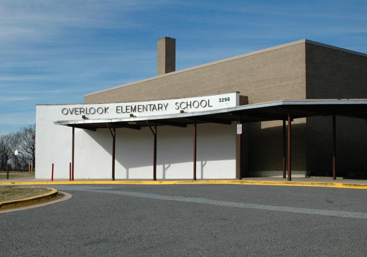
for low-intensity residential (5-acre lots) development as well as conservation of land for agriculture, natural resource use, large-lot residential estates, and nonintensive recreational use. Near the Naylor Road Metro Station, this includes two cemeteries and Overlook Elementary School (3298 Curtis Drive). There are two significant parcels zoned Open Space (O-S) in the vicinity of the Suitland Metro Station; an area of forest preserves on the Suitland Federal Center and the Smithsonian Institution site. These are not utilized as open space, per se, but support and preserve green space around the federal facilities.
Public Facilities
An inventory of public facilities was made to identify the existing base of schools, parks, community centers, and fire and police facilities that serve the sector plan area. Figure 7 shows the locations of these public facilities. The figure only identifies educational facilities owned by the Prince George’s County Board of Education. There are a small number of privately-owned schools and academies that also serve the area. However, they are not shown as the purpose of the inventory is to identify adequate public facilities that are currently available. This information is
used as a precursor to analyzing the need for additional facilities if population were to increase near the station areas. All of the parks and community centers shown are owned and maintained by M-NCPPC.
Police and Fire
The District IV Police Station, located at 5135 Indian Head Highway (MD 210) in Oxon Hill, serves all of the sector plan area south of Suitland Parkway. The sector plan area north of Suitland Parkway is part of the District III patrol area, with the patrol headquarters located at 7600 Barlowe Road in Landover. In both cases, patrol is primarily based in patrol cars monitoring large areas; there are no substations within the sector plan area.
The Morningside Fire/EMS Station, with two engines, one ambulance, and one rescue squad, is located just outside the sector plan area at 6200 Suitland Road; the 2008 Approved Public Safety Facilities Master Plan recommends replacing the station beyond the 2012–2017 Capital Improvement Plan (CIP) period.
Sector Plan Area
Sector Plan Area
Schools
Two public schools are located within the plan area and several just beyond the sector plan area boundary. The two within the sector plan area are Overlook Elementary (3298 Curtis Drive), and William Beanes Elementary (5108 Dianna Drive). William Beanes Elementary is in the Dianna Woods subdivision in the Suitland area. It is currently at 66 percent capacity. Overlook Elementary is in the immediate Naylor Road Metro Station area within a half mile of the station on Curtis Drive. Overlook Elementary is currently at 51 percent capacity.
Suitland Elementary, just outside the sector plan area, is a new school constructed partially on property acquired as part of the Suitland Manor redevelopment project, and has capacity for enrollment growth. Panorama Elementary is near the Southern Avenue Metro Station, but is separated from the station by steep slopes. Current enrollment is 53% of the capacity.
Suitland High School, located at 5200 Silver Hill Road, a few blocks to the east of the sector plan area, is in the CIP
for 2012–2017 for construction of a new annex building and the addition of new classrooms. Suitland High School is currently in three buildings, some of them dating from the 1950s, with additions and renovations in the 1980s, which are themselves approaching 30 years old.
The high school has a large student body with an enrollment over 2,100 students for the 2011–2012 school year. Suitland High School is an arts magnet school offering gifted students a curriculum in its Center for Visual and Performing Arts. The campus also includes the Annabelle Ferguson Auditorium and a vocational center that host a technical training program. Suitland High School also hosts a rigorous International Baccalaureate (IB) Magnet Program that offers students a course of study recognized through a UNESCO sponsored organization.
This sector plan projects an increase of 1,275 townhouses and 1,675 apartments by build-out. Based on the current pupil yield factors, the dwelling unit growth is projected to yield an additional 414 elementary
Table 4: Pupil Yield Factors
students, 241 middle school students, and 291 high school students.
Using the Prince George’s County Public School Official Enrollment for School Year 2012-2013, the capacity of elementary schools serving the sector plan area is 59 percent. Drew-Freeman Middle School operates at 60 percent capacity and Suitland High School operates at 75 percent capacity. Based on the aforementioned analysis, the existing public schools which serve the sector plan area have adequate capacity on the elementary, middle and high school levels to accommodate projected sector plan growth at buildout.
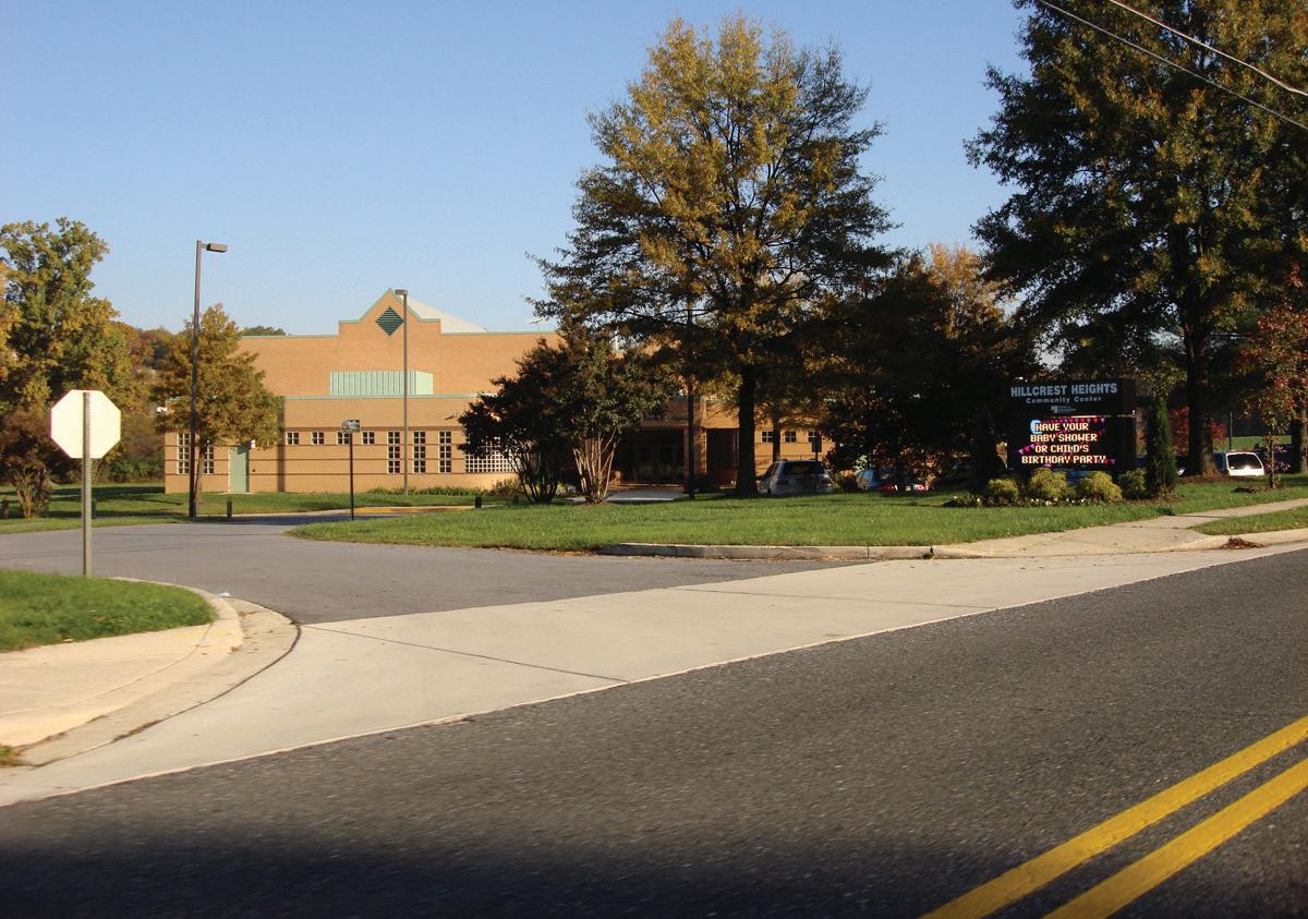
Hillcrest Heights Community Center is an important community asset with a gymnasium, meeting rooms, and outdoor playing fields.
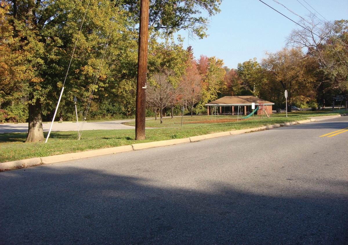
Oxon Run Neighborhood Park is located on the edge of the Hillcrest Heights Neighborhood.
Overlook Elementary School is near the Naylor Road Metro Station.
Sector Plan Area
Libraries
The Prince George’s County Memorial Library System has one facility serving the sector plan area. The Hillcrest Heights branch is just outside the sector plan area boundary, one block south of Iverson Mall at 2398 Iverson Street. The library was closed for a $750,000 renovation during the first half of 2012. The renovation brought the facility into compliance with regulations established by the Americans with Disabilities Act (ADA) and provided 61 public computers, a group study room, a wireless laptop area, new customer service desks, enhanced children and teen areas, and new windows, carpeting, and paint. Other nearby libraries in the County’s library system are located outside the sector plan area in District Heights and Oxon Hill.
Parks
Parks are an important amenity for attracting new residents and also for placemaking and community identification. The M-NCPPC owns and maintains six park facilities that are located all or partially within the sector plan area. In the general sector plan area, park facilities are of three basic types: stream corridor buffers, combined park and school facilities, and neighborhood parks.
At the southwest corner of the sector plan area, the Barnaby Run Stream Valley Park (4609 Wheeler Hills Road) protects the stream corridor on both sides of Wheeler Road. Panorama Elementary School is partially built on parkland southeast of the Southern Avenue Metro Station and the sector plan boundary. That parkland protects steep slopes and provides athletic fields for the school.
Oxon Run Stream Valley Park is an important amenity between the Southern Avenue and Naylor Road Metro Stations. The park is 80 acres in two parts, with an additional 30 acres in the middle where Hillcrest Heights Community Center is located. The community center
(2300 Oxon Run Drive), built in 1991 and recently renovated, is an important civic place providing meeting rooms, a gymnasium, a fitness room, and recreational programming. The outdoor facilities include a tennis court, two playgrounds, and a softball/baseball field. At its northern end Oxon Run Neighborhood Park meets additional open space across from the Naylor Road Metro Station that is part of Suitland Parkway owned by the National Park Service (NPS). Oxon Run is a tributary of the Potomac River and its watershed covers roughly half of the sector plan area. A multiuse recreation trail is planned to run through Oxon Run Park.
Two undeveloped neighborhood parks are located in Hillcrest Heights west of Iverson Street, one along MD 5 (Branch Avenue) and one along 23rd Parkway. Marlow Heights Community Center 2800 St. Clair Drive) is another facility serving the population in this area, and is currently under renovation.
Environmental Resources
The Southern Green Line sector plan area contains environmental resources such as forests, streams, wetlands, and 100-year floodplain that provide some stormwater quality and quantity control. The area’s geography is a rolling, coastal plain with broad ridges that fall to relatively steep slopes shaped by creeks and two main streams: Oxon Run and Henson Creek. These two streams are located within the Middle Potomac River basin of the Chesapeake Bay Watershed. Efforts to reverse the degradation of the Chesapeake Bay ecosystem include regulations that will affect redevelopment in the sector plan area.
The sector plan area is mostly developed, with the majority of land development occurring from the 1940s through the 1970s, prior to the adoption of the current County Code requirements regarding woodland conservation and stream, wetland and floodplain protections. At that time both the quality and quantity of stormwater runoff were controlled by regional stormwater management ponds. The concept of using regional ponds proved to be ineffective because the
Table 5: Watersheds, Impervious Surfaces, and Water Quality
Table 6: Watersheds Countywide and within Sector Plan Area
Sector Plan Area
streams between the sites and the ponds became very degraded and the ponds themselves received large amounts of sediment. Uncontrolled or poorly controlled stormwater has adversely affected the natural environment and continues to affect stream quality in both watersheds. Nearly half of the sector plan area is within the designated network of the 2005 Approved Countywide Green Infrastructure Plan
Watersheds and Stormwater Management
The sector plan area is in the Henson Creek and Oxon Run Watersheds, which drain to the Middle Potomac River basin. The high point formed by MD 458 (Silver Hill Road) and MD 414 (St. Barnabas Road) within the sector plan area. It is an approximate dividing line between the two watersheds. The area west of this dividing line flows to the Oxon Run Watershed. The area to the east drains to the Henson Creek Watershed. The two watersheds have been degraded by many years of development. The quality of water entering the remaining streams is compromised when there are no site features such as bioretention areas or stormwater ponds to manage
stormwater coming from impervious surfaces (roads, parking lots, rooftops, sidewalks, etc.). A summary of the watersheds’ acreage within the County and within the sector plan area is shown in Tables 5 and 6.
A geographic information system (GIS) analysis of impervious surfaces was performed to understand how the development pattern is impacting stormwater runoff. The analysis of impervious surfaces included asphalt on road and parking lots; concrete on roads, sidewalks, and driveways; building footprints (roofs) and other structures. The most recent National Water Quality Inventory reports identify runoff from urbanized areas as the leading source of water quality impairments to surveyed estuaries. According to the Environmental Protection Agency (EPA), “as little as 10 percent impervious cover in a watershed can result in stream degradation.” Impervious surface areas comprises 32 percent of the sector plan area, contributing to poor stream habitat conditions and very poor water quality conditions.
Current Maryland law and the County’s 2010 stormwater ordinance require environmental site design (ESD) be used to control stormwater from new and redeveloped sites. The goal is to manage stormwater by using ESD to reduce impervious surfaces and runoff, store and reuse rainwater, and increase groundwater recharge. This will help reduce stream channel erosion, pollution and nutrient loading, siltation, sedimentation, and local flooding. Revitalization of the sector plan area is an opportunity to protect and enhance the water quality within the two watersheds through the careful planning of new land uses, and the placement of restoration and stabilization projects as development occurs.
Table 7: Streams, Wetlands, and Floodplains
Table 8: Tree Canopy Comparison 1938-2009
The bridge over the Oxon Run stream provides pedestrian access to the Southern Avenue Metro Station. In the distance the land rises above the stream valley floor.
Oxon Run
Barnaby Run
Henson Creek
Figure 8: Topography and Environmental Features
Sector Plan Area
Wetlands and Floodplain
There are approximately 82 acres of known wetlands, 190 acres of 100-year floodplain mapped by the Federal Emergency Management Agency (FEMA), and nearly 28 miles of known streams (15 percent of which are channelized), from the two watersheds (Table 7). The 100-year floodplain represents an area adjacent to a stream with a one percent or greater probability of flooding in any given year. Floodplains are considered non-buildable portions of a land parcel; they must be preserved to the fullest extent possible. The County
Floodplain Ordinance requires an equal volume of compensatory storage be provided where filling in the floodplain is unavoidable.
Stream Corridor Assessments
M-NCPPC, in conjunction with the Prince George’s County Department of Environmental Resources (DER), funds stream corridor assessments (SCAs) for all streams within the County, including Oxon Run and Henson Creek. The state Department of Natural Resources created the SCA protocol in order to rapidly
assess the general physical condition of a stream system. This data can then be used to identify the location of a variety of common environmental problems within the corridors of these streams. Both M-NCPPC and DER utilize this data to make management decisions concerning stream preservation and restoration. Common physical problems identified during a SCA include:
• Erosion sites
• Inadequate stream buffers
• Fish migration blockages
• Exposed or discharging pipes
• Channelized (concrete) stream sections
• Trash dumping sites in or near stream construction
Woodland Conservation and Tree Cover
Aerial photographs of the sector plan area in 1938 show a mix of densely forested areas and patches of agricultural lands. Portions of these forests were cleared to facilitate residential, commercial and industrial uses, as well as the construction of Suitland Parkway and the Metrorail. Despite this, the sector plan area still contains more than 1,000 acres of woodland comprising about 31 percent of the area. This exceeds the goals set by the 2002 General Plan for tree and forest canopy in the Developed Tier. Some of these forests are protected by their inclusion in the Stream Valley Park system.
Table 8 provides a summary of the trends in tree canopy coverage in the plan area between 1938 and 2009.
The County’s Woodland and Wildlife Habitat Conservation Ordinance implements state regulations controlling the removal of woodland. These regulations require that development projects take all practicable steps to avoid or minimize removal of woodland and tree cover, and to replace removed trees. Priority areas identified for tree planting include stream buffers. Additionally, the Tree Canopy Coverage Ordinance
Figure 9: Green Infrastructure Network
Sector Plan Area
requires any project subject to it to provide a minimum amount of tree canopy coverage (10 to 20 percent based on zoning). This ordinance typically applies in urban areas where existing trees could not be preserved.
Green Infrastructure Plan
Nearly 1,650 acres, primarily along stream corridors, of the sector plan area is within the designated network of the 2005 Approved Countywide Green Infrastructure Plan as shown in Figure 9. The green infrastructure network is categorized in three ways:
• Regulated area
• Evaluation area
• Network gap
Regulated areas shown as part of the network are conceptual in nature and include known streams and wetlands with their associated buffers, regulated slopes, and the 100-year floodplain. While these environmental resources are protected by regulations at the County, state, or federal level and should not be disturbed, they can play an important role as amenities to high-intensity land uses.
Evaluation areas include environmentally sensitive features such as interior forests, colonial waterbird nesting sites, and unique habitats that are currently not protected.
Network gaps are adjacent to, or between the Evaluation and Regulated Areas, and are targeted for restoration in order to enhance the overall function and connectivity of the green infrastructure network.
Environmental regulations require that ecological resources on a site must be evaluated during the land development process. Field work is needed to specifically identify locally significant areas for addition to the green infrastructure network, and delineate the regulated features and their associated environmental
Table 9: Projected 65 dBA Ldn Noise Contours
Road Segment Road
Classification Contour Distance (feet)
Suitland Parkway (NPS Facility)
District of Columbia Line to Branch Avenue Freeway 228
Branch Avenue to Silver Hill Road Freeway 196
Silver Hill Road to Suitland Road Freeway 181
MD 218 (Suitland Road)
Silver Hill Road to Suitland Parkway Arterial 78
Suitland Parkway to Capital Beltway Arterial 91
Capital Beltway Interstate 1
MD 5 (Branch Avenue)
Capital Beltway to St. Barnabas Road Expressway 507
St. Barnabas Road to Silver Hill Road Expressway 422
Silver Hill Road to Suitland Parkway Expressway 422
Suitland Parkway to the District of Columbia Line Expressway 283
MD 637 (Naylor Road)
District of Columbia Line to Branch Avenue Arterial 67
MD 414 (St. Barnabas Road)
Silver Hill Road to Branch Avenue Arterial 181
Branch Avenue to Temple Hill Road Arterial 196
MD 458 (Silver Hill Road)
East of Branch Avenue Arterial 78
St. Barnabas Road to Suitland Parkway Arterial 181
Suitland Parkway to Suitland Road Arterial 196
1Some of the I-95/I-495 (Capital Beltway) noise is mitigated by the noise wall along the length of highway that runs through the sector plan area.
protection buffers before development applications can be approved. These areas may include larger areas than the conceptual regulated areas mapped as part of the designated countywide network.
Air Quality
Prince George’s County is part of the Washington Metropolitan Area, which does not currently meet the Environmental Protection Agency’s (EPA’s) National Ambient Air Quality Standards. This creates health issues for vulnerable populations such as children and the elderly, stemming from exposure to ground-level ozone. Ground-level ozone is formed by the chemical reaction between oxides of nitrogen and volatile organic compounds in the presence of sunlight. Major sources of the pollutants that form ground-level ozone include utility and industrial emissions, motor vehicle exhaust, chemicals from dry-cleaning establishments, vapors from small gasoline-powered engines such as lawn mowers, and small businesses using solvents, insecticides and paints. According to the University of Maryland, College Park motor vehicles account for approximately 30-40 percent of the pollutants that form ground-level ozone in the Washington and Baltimore areas.
Ozone-causing pollutants can be windborne hundreds of miles from their original source before reacting to form ozone. This requires Prince George’s County to be part of ongoing regional efforts to reduce emissions. As part of this sector plan, reductions to contributing sources include efforts to encourage people to reduce motor vehicle use, concentrate residential units near transit, and increase urban tree canopy.
Noise
Noise is defined as unwanted sound from constructed or natural sources. Excessive noise significantly affects the quality of life within a neighborhood. Noise levels are measured in decibels (dBA) and in Day-Evening-Night Sound Level average (Ldn or Lden). A noise level of 0 dBA is the threshold of human hearing and is barely audible even under extremely quiet conditions. Normal speech has a level of about 60 dBA while a noise level of 65 dBA
Sector Plan Area
is the accepted maximum level for outdoor activity.
In urban areas transportation system infrastructure, such as elevated Metrorail and busy roads, are the most obvious sources of noise. Roadways classified as arterial or higher produce enough noise to result in unsafe levels (e.g. noise levels above the state standard of 65 dBA Ldn) for outdoor activity areas. Measures must be taken to ensure that noise levels in outdoor activity areas are reduced to 65 dBA Ldn or less and interior noise levels are reduced to 45 dBA Ldn or less when uses, such as residential dwellings, hotels, schools, or day care centers, are planned within the 65 dBA Ldn noise contour (A line drawn on a map that represents all areas affected by noise levels at or above 65 dBA Ldn).
A noise model was used to calculate a conservative estimate of the location of areas affected by 65 dBA Ldn roadway generated noise in the sector plan area. Table 9 identifies the major roadways that produce noise levels at or above 65 dBA Ldn and the distances from
the centerlines of these roadways that are affected. It is evident that along most major roadways found within the sector plan area, the 65 dBA Ldn noise contour falls within 200 feet of the street centerline. However, there are instances, mostly along MD 5 (Branch Avenue), where the 65 dBA Ldn noise contour extends beyond 200 feet of the street centerline. In these cases, the placement of residential land uses and similar uses must be carefully considered to mitigate noise impacts.
Sewer Capacity
As part of ongoing coordination with the Prince George’s County Planning Department, the Washington Suburban Sanitary Commission (WSSC) prepared an assessment in 2013 of sewer capacity near Metrorail stations in the County, including the four stations along the Southern Green Line. New development, especially residential development brings with it increased use of water for sinks, showers, and toilets and can stress the capacity of the sewer system. The design of the system in the plan area relates to the two watersheds already discussed. Currently, development projects generating 100,000 gallons per day (gpd) or greater are required to be evaluated under WSSC’s Standard Procedure ENG-11-01.
The Blue Plains Wastewater Treatment Plant in the District of Columbia services the Oxon Run Basin, including the Southern Avenue, Naylor Road, and Suitland Metro Station areas The 2013 evaluation shows that WSSC peak flows, from its Oxon Run basin draining into the District of Columbia from the sector plan area, currently exceed the Blue Plains Intermunicipal Agreement (IMA) limit. WSSC concludes that this issue will need to be addressed for any significant development or redevelopment project is added to the system. Currently, recommended development projects generating 100,000 gallons per day (gpd) or greater are required to be evaluated under WSSC Standard
Procedure ENG-11-01. Based on current capacity assessments, significant development or redevelopment with flow generating 100,000 gpd or greater would require infrastructure improvements.
The Branch Avenue Metro Station area is in the Piscataway Treatment Service Area and the Broad Creek basin, which serves the Henson Creek Watershed. WSSC performed a Sewer System Evaluation Survey (SSES) for the Broad Creek basin. Modifications are required to the Broad Creek Wastewater Pumping Station and Force Main system to convey Broad Creek basin flow to the Piscataway Wastewater Treatment Plant This project is scheduled for completion in July 2016. Any recommended development upstream of the Broad Creek Wastewater Pumping Station is dependent on the Broad Creek WWPS Augmentation Project. As with the Oxon Run Basin, recommended development projects generating 100,000 gpd or greater are required to be evaluated under WSSC Standard Procedure ENG-11-01. Available capacity in this sewer basin will be reassessed after the sewer rehabilitation projects are completed. Overall, based on current capacity
A view looking down toward MD 637 (Naylor Road) and the Metro station; notice that the slight elevation provides views of development on the hills in the District of Columbia
A Metrorail train on an embankment near Henson Creek rounds the curve approaching the Branch Avenue Metro Station. The pond was constructed for stormwater management.
Figure 10: Regional and Local Roadway Network
Sector Plan Area
assessments, significant development or redevelopment in the upper portion of Broad Creek Basin will require infrastructure improvements in the Henson Creek Trunk Sewer.
Transportation
The transportation system serving each of the Southern Green Line stations seeks to provide access to Metrorail via motorized and non-motorized modes with varying degrees of success. Although WMATA’s stated policy is to favor pedestrian and bicycle access modes, then buses, then automobiles, at the four stations the access pyramid is inverted. Far easier access is given to cars and buses than pedestrians or cyclists. This is partially due to the suburban environment in which the stations are located. Analysis of the transportation options to each station is organized and ordered by mode share, starting with the roadway network and traffic issues near each station, then mode share data, travel patterns and parking data, then listing bus routes and facilities, and then discussing pedestrian and bicycle issues and facilities. The analysis concludes with a review of the issues regarding station circulation and facilities.
Major Roadways and Street Network
The sector plan area is framed by MD 4 (Pennsylvania Avenue) to the north, Wheeler Road to the south, Southern Avenue to the west, and the I-95/I-495 (the Capital Beltway) to the east (Figure 10). This large area of suburban development has three major roads leading to the District of Columbia; Suitland Parkway, MD 5 (Branch Avenue), and MD 4 (Pennsylvania Avenue). However, MD 458 (Silver Hill Road) is the only arterial connection between MD 4 (Pennsylvania Avenue), Suitland Parkway, and MD 5 (Branch Avenue) between Southern Avenue and the I-95/I-495 (the Capital Beltway). The I-95/I-495 (the Capital Beltway) is a major transportation resource providing access to the entire the District of Columbia metropolitan area.
Figure 11: Branch Avenue Metro Station Access Road -Project (Woods Way)
Sector Plan Area
Suitland Parkway is owned and maintained by the National Park Service (NPS) and classified by the County as a freeway; it primarily serves trips passing through the area, with access points only at MD 637 (Naylor Road), MD 5 (Branch Avenue), MD 458 (Silver Hill Road), and MD 218 (Suitland Road). Given this limited access and its position between MD 4 (Pennsylvania Avenue) and MD 5 (Branch Avenue), Suitland Parkway is a significant barrier to a connected network of local roads. Subdivisions north and south of the parkway are served by a maze of streets, many leading to dead ends, which forces traffic out onto the main highways and hinders pedestrian connections.
The right-of-way of Southern Avenue lies completely within the District of Columbia This major route is discontinuous between MD 637 (Naylor Road) and MD 5 (Branch Avenue), forcing traffic into Prince George’s County and the area around the Naylor Road Metro Station. MD 218 (Suitland Road) is classified as a collector between Southern Avenue and MD 458 (Silver Hill Road), but the portion east of MD 458 (Silver Hill Road) is classified as an arterial. The stretch of 23rd Parkway located between the Southern Avenue Metro Station and MD 458 (Silver Hill Road) is classified as a collector. Auth Road and Auth Way are collectors in the immediate vicinity of the Branch Avenue Metro Station and the I-95/I-495 (the Capital Beltway).
The system of residential streets serving the majority of the Southern Green Line sector plan area is haphazard and disconnected. However, the Hillcrest Heights neighborhood north of 23rd Parkway has the most connected system of streets.
Roadway Network Functional Classification and Connectivity
Within the sector plan area, there are only 14 roadways that are functionally classified as collector level or higher facilities based on the 2009 Approved Countywide
Master Plan of Transportation (CMPOT), as follows:
Table
10: Road Classification
Major Roadways Roadway Classification
23rd Parkway Collector
Auth Place Collector
Auth Road Collector
Auth Way Collector
Branch Avenue Arterial north of St. Barnabas Road and Expressway south of St. Barnabas Road.
Iverson Street Collector
Naylor Road Arterial
Silver Hill Road Arterial
Southern Avenue Minor Arterial (DDOT) or collector
Suitland Parkway Freeway
Suitland Road Collector north of Silver Hill Road and Arterial south of Silver Hill Road.
Suitland Parkway Freeway
St. Barnabas Road Arterial
Wheeler Road Collector
The areas surrounding the four Metro stations are heavily reliant on only a handful of roadways to facilitate traffic flow within the area. A count of collector and higher level roadways within a half mile of each station yields the following result:
• Southern Avenue Metro Station has four roads, three of which are within the District of Columbia
• Naylor Road Metro Station has four roads
• Suitland Metro Station has three roads
• Branch Avenue Metro Station has three roads
As a result, these station area roadways are wide with high traffic volumes and do not provide welcoming or efficient environments for bus transit service, pedestrians, or bicyclists. This sparse road network
is challenged to provide the infrastructure typically required to support a successful transit-oriented development (TOD).
Ideally, arterial roadways should be spaced at no more than one-half mile intervals to ensure efficient traffic flow, multiple and direct routes to destinations, and ease of use for all modes, including transit, pedestrians, and bicyclists. Collector roadways can be spaced at one-quarter mile, or one-eighth mile intervals to ensure appropriate network connectivity and appropriate access to destinations. If arterials and collectors were spaced at these recommended distances to create a grid of streets, each of the stations would have up to ten of these classified roadways within its half-mile area, rather than the three or four they currently have.
Grid roadway networks, rather than concentrating traffic on just a few roads, disperse traffic onto many roadways. By spacing roadways closer together, each can have fewer lanes and lower traffic volumes. Grid roadway networks are, therefore, typically more supportive to pedestrians and bicyclists and are also transit-friendly, as they allow transit vehicles to avoid backtracking and offer users direct access to transit stops.
Planned Roadway Projects
The 2009 Approved Countywide Master Plan of Transportation (CMPOT) incorporated the street, road, and highway recommendations for this part of Prince George’s County made by the 2000 Approved Master Plan for the Heights and Vicinity (Planning Area 76A). The principal recommendations relevant to the sector plan area are the continuation of 23rd Parkway as a four-lane collector from the District of Columbia line to MD 414 (St. Barnabas Road), and continuation of Iverson Street as a four-lane collector in a 100-foot right-of-way from MD 5 (Branch Avenue) to Owens Road.
Sector Plan Area
A major project of the Maryland State Highway Administration (SHA), also included in the 2009 Approved Countywide Master Plan of Transportation (CMPOT), is the Branch Avenue Metro Station access road, phase two project, which is an approved and funded project, to create a new, dedicated, grade-separated, access road, named Woods Way, starting from MD 5 (Branch Avenue) and ending at the Branch Avenue Metro Station (shown in blue in Figure 11). The project will depress northbound MD 5 (Branch Avenue) and construct an overpass that will carry the southbound turn lanes over MD 5 (Branch Avenue) to a new four-lane divided access road (Woods Way). The SHA expects this project to improve access and reduce traffic on Auth Way and Auth Road.
Following designation in 2010 of the Branch Avenue Metro Station and Naylor Road Metro Station areas as priority TOD sites by Governor Martin O’Malley, the SHA funded a $650,000 study of Complete Streets improvements in the immediate vicinity of the Naylor Road Metro Station. This study, currently under way, will create preliminary engineering concepts for improved pedestrian and bicycle facilities along MD 637 (Naylor Road) and MD 5 (Branch Avenue) in keeping with the recommendations of the 2008 Approved Branch Avenue Corridor Sector Plan and Sectional Map Amendment
Traffic Analysis
Traffic flow in the sector plan area is generally good, but directional by time of day. The existing traffic volumes are oriented towards the District of Columbia, with heavy a.m. volumes into the downtown and heavy p.m. volumes out. While there may be pockets of congestion at certain intersections and at certain times of the day, the overall system-wide congestion levels are not high. Off-peak direction travel is generally uncongested.
Table 11: Latest Traffic Counts and Roadway Capacity
Sector Plan Area
Annual average daily traffic (AADT) volumes were gathered for sector plan area roadways from a variety of sources. The majority of these traffic counts are confined to the major roadways in the area, although some collector roadways also have counts (Table 11).
Within the I-95/I-495 (the Capital Beltway) and the Developed Tier, Prince George’s County adopted a levelof-service (LOS) standard of E. Three locations on MD 5 (Branch Avenue) have a LOS of E. These segments are northbound MD 5 (Branch Avenue) between Colebrooke Drive and MD 637 (Naylor Road); MD 5 (Branch Avenue) between MD 458 (Silver Hill Road) and MD 414 (St. Barnabas Road); and MD 5 (Branch Avenue) between Auth Way and Auth Road. While these counts may indicate the roadway is nearing capacity, they are still within the adopted LOS of E.
Of the 28 locations with counts, four have a LOS rating of F. These are: MD 5 (Branch Avenue) between Southern Avenue and Suitland Parkway, Southern Avenue from 23rd Parkway and the Suitland Parkway overpass, MD 218 (Suitland Road) west of MD 458 (Silver Hill Road), and Wheeler Road east of Southern Avenue.
Southern Green Line Metrorail
The Green Line was one of the original lines planned by the Washington Metropolitan Area Transit Authority (WMATA) in the 1960s. The line took decades to plan and construct with many social, political, environmental, funding, and legal challenges slowing implementation through the 1970s and 1980s. The first extension of the Southern Green Line from L’Enfant Plaza to Anacostia opened in December 1991, but disagreement over the alignment into Prince George’s County continued to delay further extension. One recommended alignment followed Suitland Parkway to the general area where MD 5 (Branch Avenue) meets the I-95/I-495 (the Capital Beltway), while a competing alignment would have followed Wheeler Road south to Rosecroft Raceway. After many years of controversy,
construction of the Suitland Parkway to MD 5 (Branch Avenue) alignment began in 1995. The extension added a station at Congress Heights in the District of Columbia and four stations in Prince George’s County: Southern Avenue, Naylor Road, Suitland, and Branch Avenue. The five new stations opened on January 13, 2001.
Metrorail Ridership
Ridership on the Southern Green Line in the sector plan area has grown at a compounded annual growth rate of 2.8 percent, substantially higher than the 1.7 percent growth rate for the entire Metrorail system during the same time period. Ridership levels peaked in 2008, when 23,095 riders boarded at the four stations. Since that time, however, ridership has fallen five percent; far greater than the one percent decline in the overall Metrorail ridership during that period.
Ridership on the Southern Green Line in the sector plan area is heavily peak-oriented, with major flows into the District of Columbia in the morning and from the District of Columbia in the evening. The rail line itself has some capacity for expanded inbound peak hour ridership at current operations. Moreover, the option exists to increase train lengths, and possibly frequency, to provide greater capacity.
Off-peak direction travel serves some major employment centers in the sector plan area, most notably the Suitland Federal Center, but by and large, trains are running near capacity into the District of Columbia, and empty on the return. A more efficient service would be possible if additional work destinations existed near the four Metro stations.
Future High-Capacity Transit Service Planning
No expansions of the Green Line are under consideration at this point, but two fixed guideway projects are at different stages of development. One potential project would provide a fixed guideway extension south from the Branch Avenue Metro Station, using bus rapid transit (BRT) or light rail transit (LRT) technologies. This extension would connect the Green Line to Joint Base Andrews and locations further south. The other
Table 13: Mode of Accessing Sector Plan Area Stations
Table 12: Ridership for the Four Sector Plan Area Metro Stations (2001–2011)
Sector Plan Area
5
notable project is the Purple Line LRT, which will provide direct cross-county travel between Prince George’s County and Montgomery County to supplement existing Metrorail service, which currently requires traveling through the District of Columbia, as part of travel between the two counties. The initial phases of this project will not go through the sector plan area, but later phases are being studied that would provide connections between New Carrollton and National Harbor. The MPOT shows a hypothetical alignment through the sector plan area connecting to the Suitland Metro Station, but no study of alignment options has been done, and the Purple Line could also potentially connect through the Branch Avenue Metro Station.
The addition of more fixed guideway transit could transform existing service at Branch Avenue Metro Station or Suitland Metro Station depending upon the technology and routing selected.
Station Access
Throughout the sector plan area, the primary mode of access to the stations is via private automobile with 59 percent of the Metrorail riders for all four stations accessing the station by park-and-ride, drop-off kissand-ride, or carpooling. While this number is a majority it is not particularly high for what is functionally a commuter rail operating in a suburban setting. Large numbers of riders also ride Metrobus and other buses to the stations and, even with a very difficult pedestrian environment, one in seven riders (14 percent) walks to a station.
The transportation network in the sector plan area is largely focused on users from outside the sector plan area. Of those users parking at the stations, the majority (57 percent) are coming from locations five or more miles away from the stations. Nearly one-third of parking customers are driving from 5 to 10 miles to access a station and an additional quarter are driving from 10 to 25 miles, which is a considerable distance, indicating both the distances that Metrorail riders are driving to get to the Southern Green Line in Prince George’s County and also the traffic congestion and parking costs in downtown Washington, D.C., that make a transfer to Metrorail worth the time and cost of transferring between modes.
Table 15: Metrorail Riders per Station Parking Space
Table 14: Origin of Parking Customers
Sector Plan Area
Parking
The Southern Green Line stations are designed to function as commuter rail stations, which encourage access via private automobile and generate revenues to the Washington Metropolitan Area Transit Authority (WMATA) for parking. Given this conceptual set up, it is necessary to provide substantial parking resources at the four stations and, combined, they provide a total of 8,079 parking spaces for transit users, including 7,310 all-day park-and-ride spaces. Among the sector plan area’s four stations, Naylor Road Metro Station, with its 414 total spaces, has the smallest amount of parking.
Southern Avenue and Suitland Metro Stations both have in excess of 2,000 spaces, and Branch Avenue Metro Station has more than 3,000 spaces.
All station lots are being used to capacity, at least for the all-day spaces. On the other hand, the dedicated high occupancy vehicle (HOV) lots at Southern, Suitland, and Branch Avenue Metro Stations are practically empty, and many of the reserved spaces are unused. By reallocating the spaces among users, and eliminating the dedicated HOV lots, additional general parking spaces could be provided at no additional cost. In addition to vehicular parking, the four stations also provide varying amounts of bike racks and lockers for bike-and-ride users.
Riders per Parking Space
Analysis of mode of access data compared to existing parking supply yielded some straightforward as well as surprising results. In terms of gross number of boardings, the Branch Avenue Metro Station has the largest parking supply and also the greatest number of riders. However, after that result things become more complicated. Suitland Metro Station has the second highest ridership with 6,417 boardings—only 243 fewer than Branch Avenue Metro Station—but with 1,309 fewer parking spaces; and in fact Southern Avenue Metro Station has the second highest number of parking spaces, but
comes in a distant third in ridership.
Perhaps most surprising is the ridership for Naylor Road Metro Station, which is nearly half (46 percent) of that for Branch Avenue Metro Station, but with only an eighth as many parking spaces. A calculation of riders per parking space shows that Naylor Road Metro Station is generating 7.4 Metrorail riders per parking space, while Branch Avenue Metro Station is generating just 2.0 riders per parking space. The lower rider per space at Branch Avenue and Southern Avenue Metro Stations indicates that surrounding land use is an important factor in generating riders without providing a parking space. The Naylor Road Metro Station is better positioned in terms of land use to encourage walking to the station, despite the fact that with only 414 parking spaces the station has a smaller footprint, unlike Branch Avenue Metro Station, which is currently surrounded by a large parking lot. The mode of access analysis is provided in more detail for each station in later chapters of this report.
Bus Facilities and Service
In addition to Metrorail service, the sector plan area is well-served by 32 public bus routes that connect with the four Southern Green Line stations, and the stations also act as bus hub transfer points between routes. The majority of these routes are operated by WMATA; Prince George’s County also operates its “TheBus” on five of the routes. In addition, one commuter route is operated by the Maryland Transit Administration (MTA). Additional private services, notably the Suitland Federal Center shuttle bus, also provide connections.
All four of the Southern Green Line Metro stations offer plenty of space for bus circulation, bus shelters, and bus layovers. At the Southern Avenue, Suitland, and Branch Avenue Metro Stations more bus bay capacity is available than is currently needed or projected for. Only the Naylor Road Metro Station has a good balance between bus bay capacity and projected demand.
Current bus expansion plans, as outlined in the County’s Transit Service and Operations Plan, are modest and include the following expectations:
• Southern Avenue Metro Station—one new route that will connect to National Harbor
• Suitland Metro Station—one new route that will connect to Largo Town Center
• Branch Avenue Metro Station—four new routes and increased frequency on a fifth route.
Bicycle and Pedestrian Facilities
The existing bicycle and pedestrian facilities in the sector plan area are inadequate. Incomplete or inadequate sidewalks, barriers (fencing, transformer boxes), convoluted routing, and dangerous pedestrian/vehicular crossings are consistent factors impeding pedestrian access to all four station areas. Moreover, informal pathways and holes in fencing are clear indicators that, out of necessity, pedestrians are finding alternative access routes through the area in spite of these
Sector Plan Area
challenges.
Gaps in the sidewalk network exist along the sector plan area’s roadways. Many of the sidewalks that do exist are of substandard width, and nearly all are located at the immediate back of curb, which does not foster a friendly or comfortable walking environment.
In addition, the Americans with Disabilities Act of 1990 (ADA) guideline recommendations call for sidewalks to be a minimum of four feet wide, with five feet being desirable when possible and six feet when the walkway is at the back of the curb, with no separation strip. Currently, many of the sidewalks in the sector plan area are less than four feet wide for their entire length, with some as narrow as three feet.
Dedicated bicycle facilities are even more limited in the sector plan area. There are currently no off-road paths designed for bicycle use in the sector plan area, nor are there any marked bicycle lanes on streets. This lack of facilities is reflected in the lack of bicycle riders counted in the Metro mode of access survey from 2007, and yet bicycles were observed by the project team locked to racks at the stations. The County’s Master Plan of Transportation envisions a robust network of on-road and off-road facilities for pedestrians and bicyclists in the future. Included in the plan are:
• Bike lanes—on-road dedicated one-way bicycle facilities. Roads are signed and marked for bicycle use.
• Hard surface trails—recreational trails and other multiuse bidirectional trails.
• Sidepaths and multiuse pathways—off-road bidirectional multiuse facilities adjacent to major roads.
In summary, the non-motorized network is inadequate. Substantial improvements are needed in all areas to
encourage greater use of these modes. Details about pedestrian facilities and specific pedestrian issues are included in the detailed description given for each station area.
Summary of Key Findings and TransitOriented Development (TOD) Goals
The findings begin with two basic ideas:
• The Southern Green Line in Prince George’s County constitutes a major investment in the transportation infrastructure of the area and region.
• Its potential value can be realized through careful planning for new station area economic development in keeping with the well recognized and proven principles of TOD.
Therefore the primary goal of the plan is to promote a pattern of TOD at the four Metro stations on the Southern Green Line.
In order to craft a plan to promote this primary TOD goal, the planning process explored existing conditions during 2011 and 2012 and identified opportunities and challenges in regard to the real estate market and development process, land use pattern and potential
TOD sites, transit and the role of the stations, roadway and mobility network, public facilities and park amenities, and environmental sustainability.
Key findings for each of these topic areas are summarized below and followed by a corresponding statement of the planning and implementation goals of the Southern Green Line sector plan.
Real Estate Market and Development Potential
Key findings impacting the development potential, in terms of the real estate market, zoning, and development processes, include:
• The Metrorail Green Line segment within the District of Columbia has emerged as the region’s high-growth line in terms of households and jobs.
• Joint Base Andrews and the new Homeland Security headquarters in the District of Columbia, along with the 6,000 federal employees at the Suitland Federal Center constitute an important market generator along the Southern Green Line.
• Major land holdings at each of the four stations are held by single entities, including the Washington Metropolitan Area Transit Authority (WMATA), the County Redevelopment Authority (RDA), and private investors interested in TOD.
• Retail stock is aging and there has been no new construction in the sector plan area since 1990.
• New apartments near the Branch Avenue Metro Station are commanding high rents.
• The sector plan area itself does not currently provide sufficient market development fundamentals to support reinvestment for the asset classes (multifamily residential, professional office, lifestyle retail) that are crucial to successful TOD.
Sector Plan Area
• County impact fees are making multifamily residential developments financially unfeasible.
• A lack of by-right zoning and the threat of County Council call up of an approved application is a disincentive for developers to work in the County.
• There is a gap between the value of land, or potential profits from a development project, and the difficulty of the entitlement process.
• The mixed-use zoning district applied at the Naylor Road and Branch Avenue Metro Station areas are an impediment to new development because of requirements to include commercial uses in each project whether a market for commercial uses exists. Two buildings at Branch Avenue Metro Station included retail space that remains empty.
TOD Goals for Economic Development
1. Capitalize on access to existing and future employment centers along the entire Green Line.
2. Identify a development typology for each station area based on its existing land use, assets, unique context, and market potential.
3. Plan for catalytic public-private projects that can spur investment in new office space, and other development, in the immediate station areas.
4. Recommend strategies for using development incentives and financial tools to support private investment in the station areas.
5. Collaborate with WMATA on planning and implementing joint development projects.
6. Promote the Southern Green Line as a unique place in the region with land available for development at its Metro stations.
7. Recommend a new TOD zoning concept and urban design standards, along with a streamlined development review process.
Land Use and Urban Design
Major findings of the analysis of the current land use pattern are:
• The existing land use pattern of low- to mediumdensity residential subdivisions bounded by state highways that also serve as commercial corridors has precluded the development of walkable neighborhoods or focused commercial nodes.
• The four stations act as separate entities in the landscape, and the sector plan area does not function as a single, connected corridor.
• Piecemeal residential development along culs-desac, private drives, and parking lots hobbles the potential to define public and private space and create a network of interconnected communities.
• Each of the four Metro stations has existing TOD opportunity sites of sufficient scale to attract major developers.
• The location of the Southern Green Line stations present significant challenges to TOD, particularly in regard to steep slopes, stream corridors, National Park Service (NPS) and M-NCPPC lands, and secured federal campuses.
• There are few existing elements around which to organize new development in the station areas. These station site designs feel vast and unmanaged, and can challenge a sense of personal safety.
• The infrastructure of the stations, with its emphasis on vehicular parking and bus movement, conflicts with pedestrian access and easy connections to surrounding land uses.
Sector Plan Area
TOD Goals for Land Use and Urban Design
1. Encourage future land use patterns at each station that support and benefit from rail and bus transit.
2. Support land uses that generate increased ridership, such as high-density residential for in-bound commuters to the District of Columbia, and office or other employment uses that promote reverse commutes, out-bound from the District of Columbia
3. Design mixed-use walkable communities near each station that allow residents to access basic daily needs without requiring the use of a private automobile.
4. Locate higher-intensity land uses closest to the station.
5. Plan for a mix of housing types that are attractive to a wide spectrum of existing and potential residents, including young families, professionals and entrepreneurs, and senior citizens.
6. Emphasize placemaking in all aspects of planning and design for future development.
7. Establish basic urban forms, such as blocks, as the preferred method for shaping and defining public and private space.
8. Create a grid of streets to increase connectivity, allow for pedestrian passage to the station and to increase available frontage.
9. Improve the civic realm along commercial corridors.
10. Provide public space to celebrate the civic life of the community.
11. Highlight the topography of the Green Line, including its streams, slopes, parklands, and viewsheds as essential elements that define and add value to land in the corridor.
12. Meet state and County regulations on stormwater management through environmental site design.
13. Conserve critical environmental corridors along streams and steep slopes.
Transit Service, Roadways, and Mobility
Analysis of traffic data, field observations, and the overall pattern of transit service, roads and paths led to the following findings:
• The Southern Green Line has been operating as a very successful commuter rail since its opening in 2001, with high demand for over 8,000 parking spaces at the four stations.
• Each of the Metrorail stations acts as a transit hub for Metrobus and other bus service providers including Prince George’s County’s TheBus and MTA’s commuter bus service.
• The primary mode of access to the Metro stations is via automobile at 59 percent of users, and of those a majority at 57 percent are driving from locations more than five miles from the station. Bus to rail access accounts for 27 percent of riders.
• Mobility through the sector plan area is functional, but mobility within is limited. Specifically MD 5 (Branch Avenue) and Suitland Parkway favor trips across the area, but create real barriers to movement between local places.
• High-volume and high-speed traffic on state highways and Suitland Parkway in the sector plan area significantly impact neighborhoods, create barriers to pedestrian passage and bicycle use, and separate communities into smaller, isolated enclaves.
• Traffic flow in the sector plan area is generally good. While there may be pockets of congestion at certain intersections during peak commuter times, the overall system-wide congestion levels are not high.
• The existing pedestrian facilities and sidewalk network are incomplete and in some locations substandard.
• WMATA fencing and limited station access points block desired pedestrian paths at all four stations.
• There are currently no on-street marked bicycle lanes nor any off-street bicycle trails in the sector plan area.
TOD Goals for Mobility and Access
1. Provide a safe, convenient, and accessible transportation system that meets the basic need for travel via motorized and non-motorized modes.
2. Create a more integrated network of arterial and collector roads to facilitate travel within the sector plan area.
3. Promote pedestrian access to the station via a connected street grid and seek locations to implement the County’s Complete Streets policies, by providing sidewalks and marked bicycle lanes in the station areas.
4. Recalibrate the balance between station access, commuter parking needs, and potential joint development.
Sector Plan Area
5. Introduce new off-street trails to improve pedestrian and bicycle access to the Southern Green Line stations and neighborhood destinations.
6. Explore new express bus service as an opportunity to reduce station parking demand and congestion in the station areas.
7. Decrease the production of greenhouse gases by minimizing vehicular trips and promoting greater pedestrian and bicycle mobility.
Public Facilities and Parks
A survey of public facilities and parks led to the following conclusions:
• The sector plan area has vast areas of land owned by the National Park Service (NPS) and M-NCPPC; however, most of this land is either inaccessible, specifically Suitland Parkway, or undeveloped.
• Nearly all of the open space owned by M-NCPPC is land that follows and buffers stream corridors or is protecting steep slopes from development and provides little active recreation opportunities for area residents.
• M-NCPPC community centers are located on the edges of neighborhoods and there is a dearth of neighborhood parks and no urban parks in the sector plan area.
TOD Goals for Public Facilities and Parks
1. Seek opportunities for new public facilities that will serve as amenities to support the Green Line stations as neighborhoods of choice for current and new residents and businesses.
2. Prepare conceptual recreational trail development plans that utilize existing properties owned by M-NCPPC and the NPS.
3. Establish urban parks and plazas as amenities to add value and provide adequate open space for higher-intensity development.
4. Utilize the open space potential of Suitland Parkway.
Recurring Themes from Stakeholder Input
In addition to technical analysis of a variety of planning elements, a series of steps were taken to garner local knowledge of the sector plan area and receive direct input from stakeholders and community members. This outreach included individual interviews with key landowners in the immediate station areas, interviews with leaders of neighborhood organizations, and workshops to garner input from the general public.
A summary of key findings from the community includes:
• Obstacles to change and reinvestment in the sector plan area include crimes against persons and property and the perception of crime as a challenge, which creates a poor image for local communities; a high percentage of low-income residents limits buying power to support new retail; and the unattractive appearance of the commercial corridors, its public infrastructure and private businesses, detracts from the overall area.
• The isolated locations of the Green Line stations creates a concern for personal safety when using Metro.
• Improved retail and housing opportunities and a quality community environment need to be part of the corridor’s economic diversification.
• The need to maintain affordability must be balanced with market-rate housing.
• The area needs public investments in infrastructure, code enforcement and business incentives.
TOD Goals for Civic Organization and Participation
1. Support formation and continuation of a Southern Green Line Coalition to act as an advocacy and implementation support group.
2. Guide an ongoing open and inclusive public participation and outreach process to learn from local knowledge, identify community needs and desires, and build support for transit-oriented development (TOD) in the corridor communities.
3. Preserve, enhance, and support existing civic and business organizations as important community resources.
4. Promote the 2014 Approved Southern Green Line Station Area Sector Plan to educate and engage the public in community development activities.
Sector Plan Area
Recommendations
The Vision
Strong demand for transit-accessible and walkable neighborhoods brings new development to the Southern Green Line in Prince George’s County during the first decades of the 21st century. Once growth pressure along the Green Line in the District of Columbia spanned the Anacostia River with the opening of the new Homeland Security Headquarters near the Congress Heights Metro Station, a new generation of federal employees find the convenience of living within an easy walk
or bicycle ride of the Southern Avenue, Naylor Road, Suitland and Camp Springs (Formerly known as Branch Avenue Metro Station) Metro Stations a reason to call communities centered on those stations home.
The substantial infill development within walking distance of the stations changes the atmosphere to one safer for pedestrians. Sidewalks are the focus of neighborhood life. A dedicated public works program is started to improve and construct pedestrian and trail facilities in older post-war neighborhoods near the stations. The program helps bring Complete Street amenities and new
vibrant streetscapes to the area’s commercial corridors. This important first step to creating real transit-oriented development (TOD) would be accomplished through the sustained effort of County, state, and federal partners. Placemaking urban design amenities, including small urban parks and plazas near the stations, help to create new space for community life organized around walking.
Singles just starting their careers are attracted to new garden apartment communities, with the Naylor Triangle becoming something of a hot locale for those seeking an urban-suburban hybrid lifestyle. New families continue to renovate older houses in Hillcrest Heights and Suitland, while the post-war and baby boom generations fill new senior housing closest to the Metro stations.
A partnership forms to open up the many hundreds of acres of open space to active and passive recreational uses along Suitland Parkway and contiguous Maryland-National Capital Park and Planning Commission lands. Some developers even start to brand the area with new developments referencing ‘Suitland Park.’
Residents have found it possible to live car free on many days, both by using transit and also because their neighborhood satisfies their employment and shopping needs. Camp Springs Metro Station (Formerly the Branch Avenue Metro Station) is the most complete in terms of providing a full mix of uses in a town center. A single day’s commute after work at Homeland Security Headquarters might include a short ride on Metro to Naylor Road Metro Station to visit a dentist in a small medical office building, then back on the Metro to the Town Center at Camp Springs with a stop at the prepared foods counter at the grocery outside the station before the walk home.
Sector Plan Area
Major TOD Opportunity Sites
The Southern Green Line sector plan recognizes the sites below as major TOD opportunities based on their locations relative to the Metro station entrances; stated or known intentions of current owners; ease of development or redevelopment; and community context.
Branch Avenue Metro Station
Branch Avenue Metro Station area has several major development opportunity sites:
• Washington Metropolitan Area Transit Authority’s (WMATA) 33-acre property currently used primarily for surface commuter parking is the best single opportunity for new development found along the Southern Green Line. The plan demonstrates that the WMATA property can comfortably accommodate significant new mixed-use development on eight new downtown scaled blocks created by a logical extension of existing streets and new streets as a grid.
• Large sites owned by Prince Georgetown, LLC to the northeast (19 acres), east (9 acres) and west (9.4 acres) are all available and have been the subject of approved and submitted development proposals.
• The Seafarer’s Union holds excess land on Brittania Way, west of the station, that will have new frontage along the planned Woods Way when it is constructed by SHA.
• A vacant three-acre parcel of land owned by the Roman Catholic Archdiocese of the District of Columbia on Auth Road south of the station has potential for development.
• Nearly all of the quarter-mile walk circle at the Branch Avenue Metro Station area is vacant and owned by WMATA and Prince Georgetown, LLC, both of which are very interested in bringing significant new office, residential, and retail development to these parcels. Financing structured commuter parking, and parking for other uses will be a major task along with funding roadway construction.
Suitland Metro Station
Unlike the Branch Avenue Metro Station area, Suitland Metro Station is limited by existing uses, including the federal campus, the parkway, and older commercial and residential development. But major opportunity sites are available, including:
• The former Suitland Manor site located just outside the half-mile walk circle northeast of the station is owned by the Prince George’s County Redevelopment Authority (RDA), which cleared the 22 acres for redevelopment.
• The majority of frontage next to the former Suitland Manor site is owned by Mid-Atlantic Real Estate Investments, who has also expressed interest in redevelopment.
Figure 14: Major TOD Opportunity Sites
Sector Plan Area
Naylor Road Metro Station
The Naylor Road Metro Station area has several major development opportunities:
• The Suitland Federal Center has a half mile of undeveloped frontage along MD 218 (Suitland Road) at a depth of 700 to 900 feet along MD 458 (Silver Hill Road), which GSA plans to infill over time with additional federal office space.
• Potential infill on WMATA property on vacant excess land at the intersection of Navy Day and MD 458 (Silver Hill Road) just outside the gates of the federal
• Branch Avenue Partners, LLC, owns a 15-acre former shopping center site across from the station on MD 5 (Branch Avenue). It was assembled with the intent of creating TOD. Redevelopment of this site, which has an approved detailed site plan for 1.2 million square feet of office space, has the potential to significantly transform the area around it.
• A 1.7-acre site fronting Oxon Run Drive and facing parkway open space is largely vacant, with only a nightclub on part of the block.
center, and more difficult and expensive potential infill on the surface kiss-and-ride lot between the commuter parking structure and bus plaza.
• A six-acre site at 4315 Silver Hill Road, south of, and across the parkway from, the station has been the subject of several residential development proposals.
• Lynnhill Condominiums (3103 Good Hope Avenue) presents an obstacle to investment in the station area due to ownership and structural issues. However, the site, southwest of the station, is one of the most compelling in the sector plan area, sitting high on a bluff overlooking the Oxon Run Valley with vistas of the Anacostia River and the District of Columbia.
The plan envisions how this site can be redeveloped and integrated into a better-connected pedestrian path and roadway network.
• An undeveloped four-acre parcel located south of Curtis Drive at MD 5 (Branch Avenue) is for sale.
Southern Avenue Metro Station
Development at and near the Southern Avenue Metro Station is confronted by a variety of topographic and environmental challenges. Even with these constraints the following sites have been identified as having potential for TOD:
• WMATA owns ten acres at the corner of the station access drive and Oxon Run Drive, half of which is a holding pond. This site is available now for development contiguous with the existing
Figure 15: Station Typology and Market Demand
Sector Plan Area
community. The plan also suggests a strategy for infill on surface parking lots between the station and the nearby bluff.
• The former Byrne Manor site (1501 Southern Avenue) is 15 acres with frontage along Southern Avenue southwest of the station. This property is vacant and owned by a real estate brokerage.
• A.M.E. Zion Church is working to sell the largest opportunity site in the sector plan area, 72 vacant acres at the end of Wheeler Hill Road. The church also owns an additional 28 acres in the area, but with steep slopes and streams, this land may prove difficult to develop.
Considered as a whole, the available major opportunity sites along the Southern Green Line constitute a regional resource for creating TOD with very short Metro trip times into downtown Washington, D.C.
Station Typologies
The plan explores the potential for the four stations along the Southern Green Line to function as a set of stations where each plays a specific role in the social and economic life of the community. Currently the Southern Green Line functions mostly as a commuter rail into the District of Columbia With that understanding, the plan reveals how future growth can create a land use pattern that organizes residential, employment, and shopping concentrations in a way that makes linking these land uses via Metro convenient for those who live and work along the Green Line.
In order to create a system of stations that function together, the planning process considered the following factors in setting a specific functional role or typology for each station:
• Existing land-use pattern
• Existing access to the regional roadway system
• Land ownership and available TOD opportunity sites
• Station area topography of slopes and streams
• Real estate market analysis for the sector plan area and stations
• Planned and potential public works and transit projects
• Recent development projects and planned projects, including those at Green Line stations in the District of Columbia
The real estate market analysis led to the creation of an economic development strategy that identifies opportunities and viability of new development based on statistical demand and financial analysis. The development strategy considered the following three components:
• Plan area capture of regional demand
• Financial viability of recommended uses based on achievable rents/ sale prices and development cost structure
Table 16: Market Analysis
• Feasibility of use in each station given availability of development parcels, surrounding uses, and local market economics
The development program presented for each station area is based on the factors above, allocating the projected demand for the sector plan area as a whole to the areas around each station based on competitive positioning. The development program recommendations for the sector plan area include a dense office core at Branch Avenue Metro Station, retail revitalization at Suitland Metro Station, neighborhood-oriented retail and new residential at Naylor Road Metro Station, and new
residential development with expanded product offerings at Southern Avenue Metro Station. The recommended development program phasing meets the sector plan area’s pent-up demand for TOD, and also generates its own demand internally through the creation of new housing, retail, and office space.
Not all of the development recommendations are financially viable today due to the low rent and sale prices in the sector plan area market. As the sector plan area builds out and improves, new development will create value by increasing the achievable rent and
Sector Plan Area
Table 17: Future Land Use Categories
Category Description
Commercial The Commercial category includes retail, service, and repair uses located in large shopping centers, small strip centers, and miscellaneous establishments such as automobile services and sales.
An application of this category is shown overlaid on other categories as a red stripe-hatch symbol that denotes areas where ground-floor goods and service uses should be located near Metro station entrances or important intersections.
Commercial-Office Office is added as a separate use category from other commercial uses in order to recognize planned office employment centers.
Flexible Flexible is a new future land use category that allows for office or high-density residential or storefront retail forms and uses. Flexible is distinguished from mixed use in that it can be a single land use of the three allowed uses, rather than a vertical or horizontal mix, or it can be mixed if the market supports it.
Residential Residential uses include subcategories by density, which also relate to building types.
• Residential-Low is primarily single-family detached dwellings at or below a density of 5.7 dwelling units per acre (DU/A) or below.
• Residential-Medium consists of small-lot single-family detached and attached dwellings between 3.5 and 8 DU/A.
• Residential-Medium High may include a mix of dwelling types including attached single-family units (townhouses) and multifamily units, from 8 to 20 DU/A.
• Residential-High is primarily multifamily apartments at 20 DU/A and higher.
Open Space Includes publicly owned parks and conservation areas, as well as privately owned conservation areas, such as land held in common by a homeowners’ association (HOA).
Institutional Uses such as government facilities (excluding large office buildings), public and private schools, and churches.
Transportation Metrorail facilities, including rail maintenance yards and the recommended commuter parking structures.
sale prices within the sector plan area. With the introduction of new retail and residential development, infrastructure investment, and streetscape improvements, potential tenants will be willing to pay more for office space in the future than they are today.
One of the values of the market analysis is that it guides the future land use plan by showing the potential types of growth at each station and how these types of uses can be accommodated in the future. It also shows the relative strength for development types at each station and how those might relate to each other across the Southern Green Line. Careful analysis of these market and context factors informed the visions and development scenarios for each of the four stations as well as their station typology.
Branch Avenue Metro Station
Station Type: Mixed-Use Employment Center
The plan envisions the Branch Avenue Metro Station area as a growing office employment center with a Main-Street style pedestrian shopping district, and dense, mid-rise, multifamily housing. The real estate market analysis conducted for the project concluded that of the four station areas, Branch Avenue Metro Station area is the most likely to attract redevelopment led by the private sector. The station area’s location enjoys close access to the I-95/I-495 (the Capital Beltway), and large areas of land that
have made it attractive for development. Since the station opened, three major multifamily residential projects have been built near the station. In addition to more residential development, with strong planning and execution, the analysis projects that Branch Avenue Metro Station area could be the location for a regional employment core with almost one million square feet of new Class A office space.
There is strong potential for new development to transform this suburban area into a new self-contained mixed-use community. Nearly 175 acres of the 250 acres of potential development sites are unbuilt. In addition, much of this land resides in the hands of a few owners. The area has potential for significant residential, commercial, and possibly institutional development. Unburdened by the legacy of earlier patterns of suburban settlement found around the other three stations, the mix of uses and the critical mass possible at this last station of the Southern Green Line could result in a new town with a mix of jobs, places to live, and recreational opportunities that together create a vibrant atmosphere.
The plan envisions the new Town Center at Camp Springs serviced by the Branch Avenue Metro Station as the economic engine of the Southern Green Line. Given the factors identified, the new development in the Camp Springs area will be more mixed than at the other three stations, primarily because of the much greater potential for new office development. The new housing at Camp Springs will also generate riders that use Metro to access the other employment centers at St. Elizabeth’s in the District of Columbia, Joint Base Andrews, and Suitland Federal Center. These new residents are a potential market for growth in retail at the Suitland Metro Station, and perhaps for specialty retail and services at the Naylor Road Metro Station.
Sector Plan Area
Suitland Metro Station Station Type: Government Campus/Retail Corridor and Residential Neighborhood
The presence of the large federal campus at the Suitland Metro Station suggests a station type that is specialized to its context and configuration on the ground, but still a rather common type in the greater the District of Columbia metropolitan area, where federal campuses and installations are common. Suitland is perhaps more difficult to type because of the hard separation of the federal office campus from the surrounding community, which is a suburban mix of garden apartment complexes, single-family dwelling subdivisions, and commercial use along a strip of highway. The campus and community are really two distinct areas suggesting two areas of emphasis in the station typology.
In keeping with General Services Administration’s (GSA) plans for the federal center, the plan identifies potential for growth in federal office space at the center, but based on the market analysis, the plan does not incorporate any private office space development elsewhere in Suitland. Instead, the plan identifies a market for retail growth along MD 458 (Silver Hill Road), based on high-traffic volumes and good visibility from potential sites along the highway. The former Suitland Manor site, combined with highway frontage, is deemed an excellent location for a new 250,000 square foot ‘power center,’ including big-box retailers and inline or pad retail sites. A new retail center would be the first built in the sector plan area in over 20 years, and this would bring back local shoppers who are currently shopping in other areas.
Use Plan
Naylor Road Metro Station Station Type: Neighborhood Commercial Center
The opportunities at the Naylor Road Metro Station are primarily in new multifamily housing and, over time, new retail commercial uses, that serve the growing population in the immediate station area. The market analysis identified an opportunity to position the Naylor Road Metro Station area of Hillcrest Heights as a neighborhood of choice for young professional households, many of
whom are currently leaving Prince George’s County, in part due to a lack of compelling housing options. These young professional households have incomes and spending power that appeal to national retailers. Once this base of new housing and households is established, the neighborhood can support a grocery-anchored retail center of approximately 150,000 square feet. This center may also include businesses that are currently absent due to lack of demand, including restaurants, clothing stores, convenience stores, and miscellaneous retailers.
Figure 16: Future Land
Sector Plan Area
It is important to note that the Naylor Road Metro Station area development program would not all be financially viable today. Components such as neighborhood retail and mid-rise apartments are viable in later phases based on assumptions that the sector plan area will gain value as new development is introduced.
The plan promotes the idea that the compact setting at the Naylor Road Metro Station should be particularly amenable to creating a neighborhood commercial node, or village center, at the station, defined by a concentration of new businesses on the Naylor Triangle between MD 637 (Naylor Road) and MD 5 (Branch Avenue) and surrounded by new residential on the uplands above the major roadways.
Southern Avenue Metro Station Station Type and Function: Residential Neighborhood
Given its relative isolation from the regional roadway network, and very difficult topographic issues, the market potential at Southern Avenue is clearly limited to new residential uses. Luckily, the type of housing that is best suited for the large amount of land on the bluff above the station is well within reach of the current market.
Although past planning for the area saw potential for new office uses related to the hospital on the District of Columbia side of Southern Avenue, the precarious financial situation of the hospital and the locational disadvantages led to a conclusion that there is no market for office uses within the Southern Avenue Metro Station area and very little market for new retail or other commercial uses.
Therefore, the highest and best use for the area around the Southern Avenue Metro Station is a master-planned community, with small-lot single-family detached houses and townhouses that appeal to first-time home buyers
from across the region. When the market for a masterplanned community is right—when developers have the confidence that there is sufficient market demand at required price points—the private sector will step in to acquire, plan, and develop a new residential community at the station.
Station Types in Function: Living along the Southern Green Line
Consideration of a market niche for growth at each of the four Southern Green Line stations provides the opportunity to imagine how Metro can connect the various employment, retail, and residential development areas. The plan provides a glimpse of how future residents, employees, business owners and patrons, and commuters might live their daily lives along the Southern Green Line.
Clearly this vision must include the role of the stations as commuter rail stops with bus transit and vehicular parking facilities. Many who experience the new opportunities at the station will interact with businesses as part of their daily commute, stopping to purchase something between getting off the train and into their car or onto a bus. That is a key aspect of transit-oriented development (TOD), and the plan is carefully crafted to position retail uses in the best locations to facilitate impulse transactions. But the picture is bigger than just commuters, with an emphasis on creating new choices for living near the stations that relies on pedestrian and bicycle access rather than park-and-ride access. The stated goal is to use the amenity of the Metro station to foster the growth of new walkable neighborhood centers, which leads to the potential for relationships between the stations.
Branch Avenue and Suitland Metro Station areas will be employment centers that attract riders for the work commute, and importantly these trips will be mostly reverse commutes from the District of Columbia out to the offices along the Southern Green Line, putting more
riders on Metrorail trains that are currently underused in that direction during the morning and evening peaks. The growth in housing at Branch Avenue and Naylor Road Metro Stations will also add to the ridership in the general direction of the commute toward the District of Columbia, which may become even more utilized when the Homeland Security Headquarters consolidations at St. Elizabeth’s are further along. That major new employment center is only the second stop away from Naylor Road Metro Station and an easy ride from Branch Avenue Metro Station as well. In this way, implementation of the plan will increase Metrorail trips in both directions throughout the day and reduce the peaking and deadheading of trains. The Southern Green Line will become like other lines on the Metro system, with so many origins and destinations, that trains are fuller and stations are active urban nodes that are the focus of the surrounding communities.
Future Land Use Plan
The 2014 Approved Southern Green Line Station Area Sector Plan is the official land use planning document for the area within the sector plan boundary. As such, this sector plan and its recommendations for future land use replaces previously approved master and sector plans for those areas that overlap, including: the 2000 Approved Master Plan for the Heights and Vicinity, 2008 Approved Branch Avenue Corridor Sector Plan, and the 2010 Approved Subregion 4 Master Plan, and the 2013 Approved Central Branch Avenue Corridor Revitalization Sector Plan. Figure 2 shows the planning areas for each of these plans.
This plan is the result of a process that focused on the station areas for the four Metro stations in the sector plan area. These four station areas are roughly defined by a half-mile radius circle centered on each station entrance; at the Suitland and Southern Avenue Metro Stations, the station area was expanded to include
Sector Plan Area
opportunity sites that lie just beyond the half-mile radius. This sector plan retains most of the future land use policies and recommendations from previous plans for areas outside of the half-mile radius of the four stations, with some exceptions as noted.
Future land use recommendations are presented for each station area in the chapters to follow, with a rationale for the and specifics on the development pattern. Recommendations outside the station areas that pertain to the remaining parts of the sector plan area are presented in this chapter along with a description of each land use category and its application.
Commercial
This future land use plan reflects the basic pattern of existing retail and service/commercial uses located along the sector plan area’s major highway corridors: MD 5 (Branch Avenue) and MD 414 (St. Barnabas Road), Old Silver Hill Road, and MD 458 (Silver Hill Road) west of Suitland Parkway. This plan recommends a basic commercial use of land along the west side of MD 5 (Branch Avenue) from Curtis Drive to MD 414 (St. Barnabas Road). This pattern recognizes the existing uses at Iverson Mall and Marlow Heights Shopping Center, which are unlikely to change in the near to medium term and helps to consolidate the potential for mixing uses near the stations. This is a change from the approved future land use policy in the 2008 Branch Avenue Corridor plan that designated all of the south side of MD 5 (Branch Avenue) from MD 637 (Naylor Road) to MD 414 (St. Barnabas Road) for mixed-use development. The MD 5 (Branch Avenue) frontage near Auth Way is retained as commercial uses, this being the area for new automobile retail.
Retail goods or services are also shown on the future land use plan as a mix of uses, indicated with a hatch
pattern, where locational advantages exist near Metro station entrances and high-visibility intersections, with the plan recommending that single-story buildings at these locations contain retail businesses or that the ground level of multi-story buildings be designed for retail and service uses. Upper levels of vertically mixed-use buildings at these locations should follow the second land use category indicated.
Commercial-Office
The plan recommends designating specific locations for offices as a separate use from the sale of goods and services. Office as used here is primarily a place of work with only minimal contact or visits from the general public, and can include research facilities, medical laboratories, and government offices. Because the majority of the Suitland Federal Center is in fact used as office space for the U.S. Census Bureau and other government agencies, the use category is shown as office, rather than institutional. The recommended land use pattern is consistent with the General Plan’s recommendation for employment centers at the Suitland Federal Center and in proximity to the Branch Avenue Metro Station.
Flexible
The Southern Green Line sector plan recommends a major innovation in land use planning with a new category called “Flexible”. The creation of this category is in response to direct and repeated requests during planning outreach from major landowners in the station areas, including Washington Metropolitan Area Transit Authority (WMATA), for flexibility in terms of planning for future use.
The Flexible category recognizes the current trends in the real estate market, namely the decreasing and weakened demand for office and retail space. These current trends are due to many factors, including the rise in teleworking, the movement away from bricks-and-mortar stores, the growth of e-commerce, and the increase in big-box chains.
All of which have altered the way businesses use land, and the way consumers purchase goods.
Within the Flexible category, specific uses are considered optional and include: commercial-office, high-density residential, institutional uses that serve the public, and commercial-goods and services, with a preference for a storefront urban form. By definition, the ambiguity of the Flexible category can refer only to future land use, since it does not correspond to an existing land use category. While the category is flexible, it excludes certain uses, so that it is defined by what is not allowed.
Uses that should not be allowed within the Flexible category include:
• automobile sales and repair;
• industrial or warehousing uses;
• single-family detached dwelling units;
• drive-through facilities; and
• suburban big-box retail forms.
In many ways the Flexible category is analogous to a mixed-use or downtown land use category, with one difference from the way Prince George’s County and other jurisdictions have sought to apply mixed use. That is, the Flexible category does not anticipate every development project to mix uses on a single property or block, and a landowner can propose to develop only a single use on the development site if that is thought to be the best use of the land. The Flexible category supports a mixing of uses, either horizontally or vertically, but it also supports single uses that respond to the market.
For instance, the market study performed for the plan concluded that specific types of high-density residential uses are market-supported at the Naylor Road Metro Station, with little demand for office uses, and therefore the plan could simply map high-density residential uses.
Sector Plan Area
However, the plan should not exclude an unexpected but supported TOD use, such as a hotel or office development, if such a project is recommended by the landowner. The Flexible land use category gives major stakeholders the chance to seek creative and best-use proposals from real estate developers.
Residential
The plan retains Residential-Low and ResidentialMedium categories for single-family subdivisions from previous plans, since these uses are stable and are not anticipated to change in the foreseeable future. Multifamily residential uses in the Residential-Medium High and Residential-High categories have also been retained, but additional areas for these uses are mapped in the station areas.
Parks and Open Space
Working from the environmental analysis performed, the plan identifies new areas for open space where development is deemed infeasible due to the presence of steep slopes or streams. This mapping does not imply any obligation on the part of M-NCPPC or any other public entity to acquire this land for parks or conservation. Currently the sector plan area contains lands unsuitable for development that are protected as commons owned by adjacent homeowners associations (HOAs). Specific locations are discussed in the station chapters.
The future land use plan also shows a small number of recommended locations for the development of public urban parks.
Transportation
While the majority of land used for transportation infrastructure is public roadways and private drives, these are not included in the land use plan. Property owned by Washington Metropolitan Area Transit
Authority (WMATA) for its rail maintenance yards at Branch Avenue Metro Station is shown in the transportation use category along with two existing and two recommended locations for commuter rail parking structures, one at each station.
Development Review and Zoning Concept
The planning process included extensive outreach to local real estate developers to gauge impressions about both the sector plan area and development issues in Prince George’s County. Many key parts of the plan were crafted in response to comments from developers familiar with the County and key property owners, including WMATA.
In addition, the real estate market analysis confirmed other disparities between the potential value of land and the fees associated with certain types of developments, the per unit fees charged to each multifamily apartment unit as a specific impediment to financing the types of high-density and mixed-use residential projects that are the cornerstone of transit-oriented development (TOD).
A number of developers stated that the current development review process in Prince George’s County is too complex and cumbersome and that the effort and expense of guiding a project through the process exceeds the residual value of the land. The zoning code in general is too complex, difficult to use, and outdated. Developers suggested a process that was similar to other jurisdictions that provide by-right zoning where the entitlement process is more easily understood both in substance and in terms of time for review.
Figure 17: Sample Shopfront Overlay Urban Form
Figure 18: Sample Build-To Line Diagrams
Sector Plan Area
In order to respond to these important bottom-line issues for implementing TOD, the plan recommends an innovative approach to land use planning and a specific zoning concept to foster the creation of new TOD in Prince George’s County. The Southern Green Line sector plan is presenting an important basis for formulating new concepts for TOD zoning and development review.
Key Regulatory Issue Considerations
The development community has expressed an interest in maximum flexibility in establishing uses in order to meet market demand over time. While this approach makes sense for the majority of the core station areas, there are select instances in which a narrower approach to use may be important:
Key retail streets: The designation of specified areas for retail that take greatest advantage of location near the stations is key to the overall placemaking goal of this planning effort.
Large-scale office areas: In order to achieve the longterm goal of job creation in specific station areas, a zone that is focused almost exclusively on office uses will ensure the reservation of land for employment at key locations.
In both these cases, the market is not currently ready to supply these key elements of the plan, and specific districts will need to be applied to reserve land for these uses in the future. In the case of the key retail streets, it may be possible to allow other uses in buildings that are constructed for retail purposes (tall ground floor with high transparency).
One community concern regarding the station areas is that new zoning will open the station sites up to bigbox retail stores and fast-food restaurants. Special consideration of the form issues surrounding singlestory uses and drive-through uses will be required. The
concept of interim uses (surface parking, especially) is also critical. In no case should interim uses be allowed to crowd out desired uses; however, phased development plans may be necessary given the current modest market demand at some of the station areas.
Parking
While there are a variety of ways to manage parking, perhaps the most sensible for the core station areas is to consider them similar to mini-downtowns, and therefore eliminate the requirement to provide parking. Development within station areas may still choose to provide parking, but it should not be required in the County code. One possible concern related to this recommendation is whether or not a fee in-lieu of parking should be provided, in order to provide additional public resources for creating shared parking. It would appear that, given the current weak market demand for station areas, this incentive (no parking requirement) should be offered in order to attract development activity. Reduced residential parking ratios should be offered within a half mile of the station areas, where it can be presumed that at least a portion of households will use transit.
New Streets and Blocks
The design work associated with each station area has revealed some key street connections that must be made in order to achieve the placemaking vision of this plan. There are two possible approaches to implementing these key connections. The first is through preparing a simple map of new streets at each station area that would be applied during site plan or subdivision review. The challenge of this option is that this static design may not work well for all developers, especially those with smaller parcels. In the alternative, including block standards in the regulations themselves, and allowing individual applicants to design their own block patterns,
Figure 19: Sample Streetscape and Stormwater Management Urban Form Standards
Figure 20: Sample Transparency Standards
Sector Plan Area
the Detailed Site Plan. At each stage, the project is subject to public hearings which yield additional conditions and potentially modify zoning entitlements.
Development Approval Process
may make more sense. The basis for measuring block perimeter and maximum block length should be based on a combination of the results of the illustrative plan exercise and the desire to break up specific large blocks within the station areas. Where street connectivity cannot be achieved, the new standards should include bicycle and pedestrian connectivity instead.
The approval process is the most significant shortcoming within the current zoning and entitlement process. The length of time it takes to obtain approvals and the lack
In general, approvals that can be issued by staff administratively are the simplest, least expensive, and most predictable. The key to administrative approvals is to provide clear and objective standards. When standards are well written, easily understandable, and calibrated specifically for the site or sector plan area in question, administrative review and approval is very effective.
The approval process in place around each station area should be replaced with new development standards and administrative review to allow for swifter and more predicable approvals. This would give the County a significant competitive advantage in a region that consistently relies on approvals at the Planning Board or District Council level.
of predictability are major impediments when it comes to getting a development approved in the County. The development review process is consistently viewed as intense for almost any project of significance. The unpredictable nature of a project’s overall entitlement (total number of units or total square footage) can also cause developers to look elsewhere, as the perceived risk regarding return on investment can significantly outweigh the benefits. The current mixed-use zones at the station areas require a two-step (Conceptual Site Plan, then Detailed Site Plan) site plan review process. The Planning Board must approve both the Conceptual Site Plan and
If the character of new development remains a concern under a zoning only approach to development review, the possibility of separate design guidelines may work well. Developers are typically willing to go through a design review process–provided that entitlements (total units or square footage and uses) remain unchanged.
In order to identify responsibilities for transportation improvements a transportation study for each station area should be prepared by the Planning Department in consultation with the Maryland State Highway Administration (SHA), County Department of Public Works and Transportation (DPW&T) and Washington Metropolitan Area Transit Authority (WMATA). This study would identify the set of transportation improvements needed in each station area and the estimated costs for these improvements. The costs for those improvements not funded for construction in the Prince George’s County’s Capital Improvement Program (CIP), the state’s Consolidated Transportation Program (CTP), or by WMATA would be negotiated between the public jurisdictions
Figure 21: Major Transportation System Recommendations
Sector Plan Area
and private developers on a case-by-case basis prior to permit issuance. At priority stations, with an undeveloped street grid such as Branch Avenue Metro Station, strong consideration should be given to County design, construction and ownership of the local street grid.
Recommended Transit-Oriented Development (TOD) Zones
Note: In 2018, subsequent to approval of this sector plan but prior to its publication, the District Council approved a new Zoning Ordinance that included new zones similar to those described in this section.
This plan recommends the creation of new TOD zones as a separate chapter and group of zones within the zoning ordinance. The creation of these new zones is recommended over the use of overlay zones, such as the Transit District Overlay (T-D-O) zone which does not change underlying zoning, or the use of the Chapter 27A mixed-use zones, which have proven too complex and confusing to apply. The existing Mixed Use-Transportation Oriented (M-X-T) Zone, as mapped at the Naylor Road and Branch Avenue Metro Station areas, has proven to be too prescriptive in terms of the required mixing of commercial space where the market only exists for high-density residential, resulting in empty ground-level storefronts. In addition, the M-X-T Zone does not include form-based urban design standards, for instance prohibiting parking lots between building facades and the public sidewalk, and has odd floor area ratio (FAR) limits.
Also, the majority of existing mixed-use zoning options carry an extraordinary requirement for process including a series of complicated steps that may in the end even result in a District Council call up after approval by the Planning Board. Developers interviewed during this planning process indicated their reluctance to engage in development in the station areas due to the uncertainty and risk associated
with these existing processes. In addition to process concerns, few of the existing available zones allow any flexibility as to use of the property, combined with the kind of benefits often allowed in station areas such as reduced parking requirements, and additional height and density.
A strategy for applying these new TOD zoning concepts is provided in each of the four station chapters. Because these zones did not exist on February 25, 2014, the sector plan only makes specific zoning recommendations where existing zoning districts can be applied.
The entire Suitland Metro Station area is within the existing M-U-TC Zone which has built-in flexibility in terms of use as well as its own design standards that may suffice to implement the plan recommendations. Below is a description of the new, recommended zones, including uses to be permitted and a discussion of the recommended design standards that are a key feature of these recommended zones.
Three new base zones and one overlay zone are recommended:
• TOD–F: A new flexible use zone allowing a variety of single or mixed uses including residential, office, and commercial uses in conjunction with a walkable urban form.
• TOD–O: A zone intended to provide for land devoted to office/employment uses.
• TOD–R: A zone that allows for a variety of housing types at prescribed densities, such as townhouses and multifamily buildings and including urban form design standards.
• SHOPFRONT OVERLAY (-SH): An overlay zone to be applied in locations where the building form must accommodate future retail uses (tall ground floors with abundant of windows).
New TOD-F, Flexible Zone
This zoning relates to the previous discussion of the new “flexible” land use category and its purpose. It is intended to provide flexibility of use to respond to the market, without requiring a mixing of uses, while ensuring walkable urban form appropriate to station areas. The allowed uses in this zone should include high-density residential uses (allowed in all upper stories, and on the ground floor except where a Shopfront Overlay is applied); all commercial uses that occur inside a building, overnight lodging, offices, and medical uses. The approach should be to provide great flexibility with regard to the allowed uses in order to jump-start the market’s response to these station areas; however, some uses should not be allowed, as follows:
• No single-family detached dwellings.
• No warehouse or self-storage.
• No industrial or other uses requiring significant truck traffic.
• No outdoor recreation.
• No vehicle service bays visible from street (car wash, oil change, gas station).
• No drive-through facilities.
• No vehicle sales surface lots or salvage yards.
• No dangerous or noxious uses that produce impacts such as smoke, glare, noise or fumes, or that create the threat of fire, explosion, or radiation exposure.
Outdoor amenity space for residents (at-grade or outdoors at upper levels) should be required for all residential development at a rate of 20 percent of the lot area. A buildto zone should be established from the back of sidewalk to no more than 10 feet from the back of sidewalk. Buildings should be required to extend at least 75 percent of the lot width in this build-to zone.
Sector Plan Area
New TOD-O, Office Zone
This zone is intended to ensure that opportunities for employment and office development near station areas are conserved until the market is ripe for them. Allowed uses should include office, medical or dental clinic, gallery, technical school, college or university, and bank. No surface parking should be allowed as a principal use. A build-to zone should be established from the back of sidewalk to no more than 10 feet from the back of the sidewalk. Buildings should be required to extend at least 60 percent of the lot width in this build-to zone.
New
TOD-R,
Residential Zone
This zone is intended to provide a transition from office and flexible use areas near stations to the surrounding residential areas. It is intended to provide walkable urban form with the possibility of mixed housing types. Allowed uses should be those residential uses currently allowed in similar districts such as Multifamily High Density Residential (R-10). No surface parking should be allowed as a principal use. Outdoor amenity space for residents (at-grade or outdoors at upper levels) should be required for all residential development at a rate of 20 percent of the lot area. A build-to zone should be established from the back of sidewalk to no more than ten feet from the back of sidewalk. Buildings should be required to extend at least 75 percent of the lot width in this build-to zone.
New TOD-SH, Shopfront
Overlay
This overlay zone would require elements typically associated with walkable retail frontages, such as tall ground floor height, high transparency (windows and doors), and build-to standards that form a street wall. A build-to zone should be established from the back of sidewalk to no more than 10 feet from the back of sidewalk. Buildings should be required to extend at least 90 percent of the lot.
Urban Form Standards
All of the new zones are intended for areas of high walkability near the stations. This means the following standards should be applied in all of the zones:
• All buildings in TOD-O and TOD-SH zones should meet a designated build-to line, creating an urban streetscape with buildings fronting a wide sidewalk.
• No parking allowed on private property between the building and the street (on-street parking is encouraged).
• Wide sidewalks (minimum 8 feet in residential areas and 10 feet in nonresidential areas, with the exception that Shopfront Overlay areas should be wider – a 15 foot minimum).
• Limits on blank wall area facing streets (maximum length of 30 feet) in order to ensure visual interest for pedestrians.
• Building setbacks should allow abutting buildings across property lines, without the need for setbacks that create gaps.
• Where parking is allowed (outside of a required buildto zone), it should be set back at least ten feet from the back of sidewalk, with a low-landscaped hedge or wall screening the parking.
• Buildings must hold the corner – building placement on corner lots must begin at the corner, with portions of the site that are not built up located toward the block interior.
• The ground floor of all residential buildings should be elevated at least two feet above the adjacent sidewalk.
• Building massing and articulation standards should be set to break up the mass of larger buildings. A typical spacing for offsets or other articulation would be every 100 feet.
• Ground floor transparency should be set based upon the building type, with high transparency for retail uses, and lower requirements for office, hotel and residential uses.
• Pedestrian access to the building from the street side must be required. A typical spacing offset is every 75 feet.
Height
Consideration should be given to eliminating height limits in the TOD-O Zone to encourage and simplify development of new employment centers. Minimum heights should be established for office and residential buildings. Standalone single-story retail buildings might be allowed in the TOD-R or TOD-F Zones, with a special permit and where the use will add to the overall provision of new retail businesses that serve adjacent residential and office uses.
Outdoor Amenity Space
Where required, outdoor amenity space must be provided on the lot and must be available as unenclosed, improved active or passive recreational space for use by the occupants of the development according to the following standards:
• Outdoor amenity space may be met in one contiguous open area or in multiple open areas on the lot; however, to receive credit the area must be at least ten feet in width and length.
Sector Plan Area
• Examples of active outdoor amenities include a playground, athletic court, pool deck, spray deck or plaza, promenade, or dog park.
• Passive park areas must include improvements such as trails, paths and seating areas. Formal or informal gardens, as well as greenbelts, are considered acceptable outdoor amenity areas.
• Outdoor amenity space may be located at or above grade. Above-grade examples include a rooftop deck or terrace, rooftop patio or fitness station.
• Outdoor amenity space cannot be parked or driven upon, except for emergency access and permitted temporary events.
Parking
No parking should be required within a half mile of all stations, as measured by walking distance from the principal entrance to the station entrance. In the alternative, a fee in-lieu of required parking should be an option for buying out of required on-site parking. The fee should be calculated based on the typical cost of structured parking in the sector plan area.
Streetscape
A high-quality streetscape/public realm must be provided by the developer to complement the on-site investment. This means the wide sidewalks described previously, street trees planted every 30 to 40 feet on center, and on-street parking wherever feasible. The build-to percentages listed above should allow exemptions for entrance forecourts and small inset areas for outdoor dining along the street edge.
On-Site Landscaping
The landscaping within every station area should incorporate vegetated screening along the edges of surface parking lots, in conjunction with tree planting in the islands of any surface parking lot. No more than ten spaces should occur in a row without an intervening island (planted with a shade tree).
Stormwater
In walkable urban areas, stormwater must be handled in ways that are not land intensive. Shared options offsite, use of right-of-way areas to manage stormwater with bio-swales, creation of stormwater storage and filtering solutions under parking areas, and reduction of impervious cover through use of pervious paving and green roofs should all be allowed. The philosophy should be to manage every drop of rain as close to the source as possible.
Major Transportation System Projects
Figure 21 presents the recommended major transportation system improvements. These projects have significance at the subregional scale and it is useful to consider them in relation to each other and the sector plan area. Each project is also associated with the station area that it is nearest and, therefore, an overview is provided in this chapter and additional details in the station area chapters that follow.
Regency Parkway Extension
The project would extend Regency Parkway as a twolane roadway with an adjacent multiuse trail from its current southern terminus over Suitland Parkway to connect with Brittania Way. The additional roadway capacity provided by this connection is necessary to fulfill the maximum buildout potential of the Branch Avenue Metro Station area. It also offers numerous benefits including enhanced regional connectivity, improved connectivity to the Branch Avenue Metro Station, the potential to reduce the cross section of other roadways such as Auth Way, and improved traffic resulting in volume reductions on parallel facilities such as MD 458 (Silver Hill Road). Preliminary modeling shows a future daily traffic demand of approximately 17,000
vehicles on this new facility. Further study is needed to determine its full impacts, including environmental; to confirm the preferred number of lanes; and to verify the costs to plan, design, acquire right-of-way and construct the facility.
Woods Way
This Maryland State Highway Administration (SHA) project will provide a new four-lane roadway (named Woods Way) from MD 5 (Branch Avenue) that connects directly to the Branch Avenue Metro Station. The gradeseparated access on MD 5 (Branch Avenue) at Woods Way, along with modifications to the existing access and traffic control at Auth Road, will enhance traffic operational efficiency along MD 5 (Branch Avenue).
MD 458 (Silver Hill Road) Multi-way Boulevard from Navy Day Drive to MD 218 (Suitland Road)
This project would add a physically separated, lowspeed, one-way access lane that would provide local access to and parking alongside the recommended retail frontage on the south side of MD 458 (Silver Hill Road), along with a highly pedestrian-oriented streetside. The primary purpose of this project is to transform this section of MD 458 (Silver Hill Road) into a friendly, walkable environment and accommodate new urban retail development while maintaining efficient traffic flow on this high-volume arterial roadway.
Suitland Parkway Interchange Ramp
Reconfiguration at MD 5 (Branch Avenue) and MD 458 (Silver Hill Road)
The purpose of these minor ramp reconfigurations is to make intersection crossings safer for non-motorized users by slowing down vehicles turning onto or off of ramps at the crossing points where pedestrians or bicyclists would be encountered. This would be achieved
Sector Plan Area
by tightening the turning radii of the ramps and using high-visibility ladder-style crosswalks. At the MD 458 (Silver Hill Road) interchange, the project includes a new shared-use path on the north side of MD 458 (Silver Hill Road) from MD 5 (Branch Avenue) to MD 218 (Suitland Road) and the reconfiguration of the MD 458 (Silver Hill Road)/Maywood Lane north approach.
Southern Avenue “Missing
Link” from MD 637
(Naylor Road) to MD 5 (Branch Avenue)
Located within the District of Columbia, this potential two-lane roadway with bike lanes and sidewalks would provide a t connection to fill the existing gap on Southern Avenue near the Naylor Road Metro Station. The connection would allow through trips on Southern Avenue to continue on that roadway without having to divert to other roadways near the station. Preliminary modeling shows a future daily traffic demand of approximately 12,000 vehicles on this new facility. Further study is recommended to determine its full impacts and benefits.
Southern Avenue Road Diet
This District of Columbia Department of Transportation (DDOT) project would narrow Southern Avenue— including the section nearest the Southern Avenue Metro Station between Wheeler Road and 23rd Parkway—from the existing four-lane section to a two-lane divided section with a median rain garden. The primary purposes of this project are to enhance the roadway and roadside environment for pedestrians and bicyclists, keep vehicles traveling at appropriately low speeds, and provide a safe and efficient roadway for all users.
23rd Parkway Road Diet from Southern Avenue to Oxon Run Drive
This project would narrow the existing four-lane undivided section to a two-lane section with enhanced on-street bicycle facilities. The existing traffic volumes and low anticipated growth on 23rd Parkway make it an ideal candidate for a road diet, as the projected 2040 volumes (approximately 12,000 to 13,000 vehicles per day) are less than the two-lane roadway capacity. The benefits of the project would be enhanced and safer environments for bicyclists and pedestrians, appropriately low vehicle speeds, and efficient traffic operations.
Regional System of Interconnected Shared-Use Pathways
This project incorporates and connects a total of 14 miles of new regional shared-use pathways within and between the TODs, including portions of the Henson Creek Stream Valley Trail, Suitland Parkway Trail, Oxon Run Trail, trails along MD 458 (Silver Hill Road) and MD 218 (Suitland Road), and numerous other connector trails and spurs. In addition, a new pedestrian overpass is recommended at the MD 637 (Naylor Road)/Suitland Parkway intersection. These pathways would provide numerous benefits to the community including easier and safer connections to the four Southern Green Line Metro stations and to other neighborhood destinations including several area schools.
Sidewalk Retrofits
A total of 10.2 miles of sidewalk is recommended to be retrofitted on existing roadways in the four station areas, including new construction of missing segments and widening of substandard width sidewalks.
Regional Bus Improvements
Recommended regional bus improvements include three new express bus routes, two new park-and-ride lots and one expanded park-and-ride lot, and a new local crosstown route, as follows:
• Indian Head Highway Express Route operating from the existing Fort Washington and Oxon Hill Park-and-Ride lots and terminating at the Southern Avenue Metro Station.
• Upper Marlboro Express Route originating at an expanded park-and-ride lot at the Equestrian Center with stops at the County Administration Building (CAB) and a recommended Westphalia park-andride lot, and terminating at the Suitland Metro Station.
• Branch Avenue Express Route using the existing Clinton park-and-ride lot and a recommended parkand-ride lot in the Brandywine area, and terminating at the Branch Avenue Metro Station. A potential alternative would be to terminate this route at the Naylor Road Metro Station (rather than the Branch Avenue Metro Station), or continue the route into the District of Columbia
• A new local crosstown route taking advantage of the recommended Regency Parkway Extension and connecting Largo to Alexandria.
• The Suitland Metro Station has about twice as many bus bays as are needed to accommodate existing and recommended services. This surplus provides several opportunities to reconfigure the arrangement of the current bays to bring them closer to the rail platform and reposition the remaining area for development.
• The Branch Avenue Metro Station has a large surplus of bus bays when the needs are evaluated based upon the frequency of service for all current
Sector Plan Area
and projected routes. The recommended concept for the Branch Avenue Metro Station reduces the number of bays to 11, which still allows for additional future growth.
Environmental Quality and Sustainability
Current Maryland law and regulations, and the County’s 2010 stormwater ordinance require that environmental site design (ESD) be used to control stormwater from new and redeveloped sites. The goal is to manage stormwater by using ESD to reduce stream channel erosion, pollution and nutrient loading, siltation, sedimentation, and local flooding, and to use appropriate structural practices, such as stormwater management ponds, only when necessary. ESD objectives include:
• Reduction in impervious surfaces and runoff
• Storage and reuse of rainwater
• Increased ground water recharge
Mixed-use development, as recommended, will provide many opportunities to restore portions of these degraded environmental systems to more natural conditions. Low impact development (LID) design and urban tree canopy requirements enforced during development/redevelopment will further enhance environmental quality in the sector plan area.
Environmental quality is an important component of the quality of place in built-up areas such as the Southern Green Line sector plan area. This plan seeks to create mixed-use development at the Metro stations while also maintaining and enhancing the environmental integrity of the area’s forest resources, air and water quality, as well as stormwater quality and quantity management. The plan endorses the concept of sustainability by concentrating development at or near transit stations, while also enhancing a green environment that includes the protection of locally significant green infrastructure elements, protection of woodland and
tree cover, creation of tree-lined streets, and the use of environmentally sensitive building technologies. This sector plan recommends:
• Seeking opportunities to reduce overall energy and resource consumption by promoting the use of more effective, energy-efficient indoor and outdoor lighting and air movement systems, and orienting buildings to maximize the potential for solar energy generation, in new development.
• Continuing to develop stream valleys as a resource for trail connections.
• Creating a comfortable pedestrian environment with urban open spaces and extensive seating along sidewalks.
• Conserving and protecting trees, woodlands, and wildlife habitat by requiring site planning techniques and construction practices that prevent adverse effects on these sensitive environmental features.
• Improving water quality using a variety of approaches appropriate to an urban setting. These should include but should not be limited to comprehensive streetscape plans using extensive tree planting, linear urban parks, and median planting; green rooftops; and using site designs that reduce surface runoff and maximize infiltration in all new and redeveloped sites.
• Coordinating land development to reduce or mitigate the effects of noise pollution.
• Protecting, preserving, and enhancing the green infrastructure network and enhancing environmental corridors by focusing development outside the network.
Sector Plan Area
Table 18: Stormwater Management and Stream Retrofit Opportunities in the Southern Green Line Station Area
Project Map Location Challenge
Recommendations
Southern Avenue Metro Station
1 Excess WMATA land south of the Southern Avenue Metro Station and east of Southern Avenue. This is a forested bluff containing areas of steep and severe slopes. Any development recommended for this area, including road access must respect the existing contours and protect steep and severe slopes from disturbance.
2 Oxon Run tributary starting north of 19 th Avenue and Panorama Elementary School (Parcel 020). This is a steeply sloping, deeply incised channel that carries significant stormwater volumes from the Oxon Run Hills neighborhood.
3 Wheeler Hills Road east of Barnaby Run Stream Valley Park.
Stormwater from the cleared and paved area (part of Parcel A EQ) east and south of Wheeler Hills Road travels towards the Barnaby Run stream via a system of existing storm drains that empty into two stormwater management ponds at the lower end of that site.
A significant portion of stormwater bypasses the ponds and flows to Barnaby Run via a deep channel separating the ponds from parkland (Parcels C and 164). This stormflow must be managed in order for development to occur.
Stormwater from the forested bluff and the Oxon Run Hills neighborhood must be managed for development to occur. Reconstruct and stabilize the stream to accommodate present and future stormwater runoff volumes. A roadway recommended at that location is not recommended due to slope and drainage issues.
Retain both ponds for stormwater quality and quantity control.
Do additional evaluation to determine whether or not the existing ponds have sufficient water quantity capacity to facilitate planned development.
4 Barnaby Run tributary that starts west of the Washington Christian Center off Culbera Drive.
5 Barnaby Run stream segment east of Wheeler Road.
Stormwater off the southern portion of the wooded bluff and areas west of Carozza Court travels to this small tributary via sheet flow while stormwater from the Washington Christian Center and vicinity travels to the stream via a concrete pipe.
The Stream Corridor Assessment (SCA) has identified several stream impairment areas along this segment of stream that should be addressed as development occurs.
Reconstruct and further stabilize the stream to accommodate present and future stormwater runoff levels.
6 Oxon Run tributary located at the southern portion of Oxon Run Neighborhood Park off 28th Parkway.
7 Naylor Road from Branch Avenue to Oxon Run Drive.
Stabilize Barnaby Run stream as mitigation for bridge construction to facilitate the extension of Wheeler Hills Road.
Consider this a priority for public investment.
Naylor Road Metro Station
A significant volume of stormwater comes off parcels on the south side of Oxon Run Drive and enters Oxon Run stream via a 200-foot concrete channel that is badly eroded and collapsing.
The Oxon Run segment receiving this stormflow is degraded, with stream bank erosion evident.
Stormwater including from parcels framed by these three roadways travels to a small pond near the train tracks from where it is piped to a small Oxon Run tributary.
Restore the length of tributary that is currently channelized and stabilize it to control the volume of runoff entering the Oxon Run stream.
Consider this a priority for public investment as mitigation for the impacts of stormwater from existing and recommended development along Naylor Road.
Evaluate the use of park property off 28th Parkway adjacent to the stream to provide for quantity and quality controls for stormwater off the Good Hope Hills neighborhood.
Evaluate whether or not the existing pond has additional water quantity capacity to facilitate recommended development. Incorporate environmental site design (ESD) into the planned development to reduce surface runoff, store and reuse rainwater, and increase ground water recharge.
Building design for properties along the southern side of Naylor Road must respect existing contours and slopes.
Increase tree canopy by 10 to 20 percent to improve air quality and assist in reducing the overall stormwater leaving the area.
Sector Plan Area
Table 18 (continued): Stormwater Management and Stream Retrofit Opportunities in the Southern Green Line Station Area
Recommendations
8 Branch Avenue from Curtis Drive to the Metro tracks.
The Oxon Run stream segment east of Branch Avenue receives untreated
stormwater off the Carriage Hills Apartments and the former Branch Metro Plaza complex (Parcel A, PTA 505-09) via a series of concrete flumes off the eastern part of the old Branch Metro Plaza complex.
Stormwater off parcels on the east side of Branch Avenue must be managed in order for redevelopment to occur.
9 Southern side of Silver Hill Road between Suitland Road and Swann Road.
Stormwater from the commercial area framed by these three roadways drains to the Henson Creek stream system via pipes that outfall behind the Church of Christ property (Lot 8EQ) at the Suitland Road Plaza and the Madison Gardens Apartments (Parcel F) on Swann Road, to a small tributary.
Stormwater off these parcels must be managed for development to occur.
The Madison Gardens Apartments fork is heavily eroded while the Suitland Road Plaza fork has a heavy trash buildup and a high percentage of nonnative invasive species.
Reconstruct these conveyances to allow them to control the volume of runoff from existing and recommended development.
In future designs utilize the space currently located between the east side of the former Branch Metro Plaza complex and the south side of the Carriage Hills Apartments, to create a bioretention area that provides for water quality and quantity controls for the stormwater passing through the two areas.
Design this feature to double as a linear park and amenity for the community, with seating areas overlooking the Suitland Parkway and the wooded Oxon Run floodplain.
Metro Station
Utilize some of the area currently available at the rear of the Sheet Metal Workers Local Union #100 property (Lots 4, 5, 6, and 9 EQ) to create a bioretention area that provides for water quality and quantity control of the stormwater passing through the area.
Consider this an opportunity for a public-private partnership and/or a coordinated fee system for the properties that will benefit.
10 Henson Creek tributary that starts east of Silver Hill Road.
The stream travels a short distance from its source off Silver Hill Road before being piped under the northern portion of Parcel A (Windham Creek Apartments) at 5115 Suitland Road, then continuing east.
Restore approximately 500 feet of the stream segment that is currently piped under the Windham Creek Apartments property and recreate the buffer to restore the original stream functions.
Consider this a high priority for public investment to fulfill the Oxon Run watershed implementation plan (WIP).
Note: If the stream is piped at its source to facilitate development as recommended then mitigation will be required for approximately 850 linear feet of the stream which will be affected.
Branch Avenue Metro Station
11 Henson Creek tributary that starts off a stormwater management facility adjacent to the Metro tracks north of Auth Way.
Stormwater from planned development off the east side of Branch Avenue must be managed to facilitate development.
Consult the SCA which has identified stream impairment areas along the Henson Creek stream system immediately east of the Branch Avenue Metro Station, to select suitable sites for restoration to mitigate for the impacts of planned development of the Branch Avenue Metro Station area.
Evaluate whether or not the existing pond has additional water quality and quantity capacity to facilitate planned development.
Reforest the stream buffer north of the pond on Auth Way.
Extension of Auth Place across the tributary is not recommended because of unnecessary stream and green infrastructure network impacts.
Planned crossing of this stream and the Henson Creek floodplain complex to the north, to facilitate Regency Parkway construction, should be a high bridge with small piers to minimize the environmental impacts.
12 Henson Creek tributary starting east of Gloria Drive in the Leah neighborhood.
This tributary shows the effects of carrying a significant amount of stormwater from the Leah neighborhood as well as from a stormwater management facility at the southern end of the Suitland Metro Station.
Stabilize the stream to accommodate present and future stormwater runoff volumes.
Suitland
Sector Plan Area
Branding and Community Development
The sector plan area includes parts of larger recognized neighborhoods, most notably Hillcrest Heights and Suitland. However, in terms of a brand to market, particularly for real estate development purposes, those names do not carry with them entirely positive connotations. Perceptions of the area due to media reports of crime can present an image that discounts the many positive qualities of established neighborhoods and the relatively new amenity value of the Green Line Metro stations. Therefore, the plan considers a number of approaches to rebranding the sector plan area and its communities to the larger metropolitan audience.
Southern Green Line Brand
A major outcome of the planning process is the recommendation to brand the four station areas as the Southern Green Line. The plan itself starts this effort. Community members, civic leaders, landowners and business owners have accepted and welcomed the idea that this segment of the Metrorail system is distinct, and that the Southern Green Line brand and its associated logo are valuable in creating a new, positive impression of the overall area.
The Southern Green Line brand also helps to conceptually unify an area of unincorporated Prince George’s County that is currently identified as separate communities, including Hillcrest Heights, Suitland, Silver Hill, and Camp Springs. These areas are close to each other, and overlap in some ways, but are separated by large roadways and topographic features. Conceiving of these neighborhoods, and specifically the station areas, as sharing a common overall space and common for community development will help to define priorities for action and lobbying efforts for public investment.
Suitland Regional Park and Trails
Like the Metrorail line, another potential amenity to promote a new brand for the area is the substantial open space owned by the National Park Service (NPS) and M-NCPPC that connects the station areas. From Oxon Run Stream Valley Park, adjacent to Southern Avenue Metro Station, to Suitland Parkway at MD 637 (Naylor Road) and Suitland Metro Station, and on to Henson Creek Stream Valley Park at Branch Avenue Metro Station, the Green Line connects many acres of open space, most of it undeveloped stream buffers and forested steep slopes. The plan recommends that further study be conducted to test the feasibility of combining these contiguous open spaces into a regional park amenity that carries with it the potential to rebrand the area as proximate to the regional park, with Suitland Regional Park emerging as a potential name.
Suitland Parkway’s length in the sector plan area is comparable to successful Rock Creek Park in the District of Columbia. It’s width is akin to successful parkways, like the Bronx River Parkway in New York. Like these two renowned examples, the regional park has the potential to become a unifying element, providing a greater identity to and linkages between all of the communities along the Southern Green Line.
The recommended Suitland Regional Park also has the potential to be a major recreational amenity and resource. Running the entire length of the sector plan area and large enough to offer a sense of escape and of being surrounded by nature, the park would form a key link in a larger trail system. These trails will also expand access options to the four Southern Green Line Metro stations. Local parks with playgrounds and playing fields would serve as gateways into the regional trail system and would help broaden the park’s appeal.
Coordination with the NPS and M-NCPPC will be necessary to promote this regional park concept along with studies for specific trail segments.
Town Center at Camp Springs, Maryland
A subject of particular concern in terms of branding is the current Washington Metropolitan Area Transit Authority (WMATA) station name: Branch Avenue Metro Station. This name is easily confused with MD 5, which is the state highway also called Branch Avenue that runs through the majority of the sector plan area. References to the highway can be easily confused with references to the station, and vice versa. In fact, the Branch Avenue Metro Station is not on MD 5 (Branch Avenue)—the station lies more than a half mile to the east of the highway, while the Naylor Road Metro Station sits immediately adjacent to Branch Avenue.
A potential approach to addressing this issue is to follow the lead of real estate developers that have used the Town Center at Camp Springs label to brand their projects in the Branch Avenue Metro Station area. Camp Springs is generally identified as a community along MD 5 (Branch Avenue) south of the I-95/I-495 (the Capital Beltway), but given the lack of a recognized name for the Branch Avenue Metro Station area, Camp Springs has been applied to project proposals in the station area, most prominently in a project known as the Town Center at Camp Springs. Further consideration should be given to formally recognize the area as Camp Springs, and decide if it is necessary to distinguish this area as the ‘Town Center at Camp Springs’ or with some other qualifier.
The most important step to fostering this branding concept is to change the station name from Branch Avenue Metro Station to Camp Springs Metro Station. Since Branch Avenue Metro Station is a terminus
Sector Plan Area
station, many station platforms and station signage refers to Branch Avenue to indicate the direction of the Green Line train and these signs would need to be changed to read Camp Springs. The advantage to this step is that the station name would refer to a place name rather than a roadway (Branch Avenue [MD 5]) that stretches across the whole southern part of the County.
Policy Recommendations for the Sector
Plan Area
1. Prioritize implementation on vacant and readily available land, working in partnership with WMATA and other major landowners interested in transit-oriented development (TOD).
2. Market the Southern Green Line as a set of four stations, each with opportunity sites that can serve a specific market niche.
3. Continue to support implementation of the Maryland State Highway Administration’s (SHA) planned Branch Avenue Metro Station access road project (Woods Way) that would connect MD 5 (Branch Avenue) directly to the Branch Avenue Metro Station.
4. Continue to study the feasibility and potential impacts and benefits of extending Regency Parkway from its current southern terminus near MD 218 (Suitland Road), across Suitland Parkway, Henson Creek and the Green Line into the Branch Avenue Metro Station area.
5. Encourage and support the District of Columbia to fill in the missing link of Southern Avenue, between MD 637 (Naylor Road) and MD 5 (Branch Avenue).
6. Support the implementation of a new right-of-way configuration, or road diet, along Southern Avenue in the District of Columbia, that will provide new and enhanced pedestrian and bicycle facilities in the Southern Avenue
Metro Station area.
7. Work with the National Park Service (NPS) to provide a trail connection along Suitland Parkway from the current terminus of the existing off-road trail at the District of Columbia line to MD 637 (Naylor Road).
8. Encourage the National Park Service (NPS) to study an off-street trail alignment along Suitland Parkway, from MD 637 (Naylor Road) to MD 458 (Silver Hill Road), and from MD 458 (Silver Hill Road) to MD 218 (Suitland Road).
9. Implement the planned Oxon Run Trail and Henson Creek Stream Valley Trail extensions to serve trips to the Southern Avenue, Naylor Road, and Branch Avenue Metro Stations, and as a recreational amenity.
10. Recognize the Southern Green Line as a specific place in Prince George’s County and encourage developers and citizen groups to identify and promote the sector plan area as the Southern Green Line.
11. Continue to study the potential for a coordinated regional park and trails development project that connects open spaces owned and maintained by M-NCPPC and NPS.
12. Establish a formal County process for renaming the Branch Avenue Metro Station, including recommending the name change to the WMATA Board. Create an item in the County budget to fund the WMATA name change fee in time for changes to be implemented when the Silver Line opens.
13. Provide flexibility in future land use for the Southern Green Line station areas, while also meeting the County’s goals for density and employment at its approved centers described in the General Plan.
14. Continue current efforts to create specific transitoriented development (TOD) zoning districts and reform
the development review process.
15. Study the potential to change impacts fees related to multifamily residential development as a means to encourage new denser residential development in station areas.
16. Designate the Southern Green Line station areas as a Transportation Policy Exception Area (SGL-TPEA). With this designation and under limited circumstances, SGL-TPEA may allow for exceptions to the County’s transportation adequacy test within a one-third mile radius of the four station entrances. The exceptions would provide flexibility for managing congestion in order to encourage a wide range of planning strategies, including parking management, vehicle trip reduction measures, greater support for mass transit usage, and timely implementation of the needed multimodal transportation network enhancements.
17. Continue to monitor the Washington Suburban Sanitary Commission’s (WSSC) progress on sewer capacity improvements in the Oxon Run basin and Broad Creek basin and advocate for further studies and projects to increase capacity as needed for new development at the four station areas.
18. Create a new set of transit-oriented development (TOD) zoning districts as a separate chapter in the zoning ordinance. Consider strategies for encouraging TOD including eliminating height limits, eliminating vehicular parking space minimums, or establishing fee in-lieu of construction of spaces as part of shared use strategies.
Branch Avenue Metro Station
Branch Avenue Metro Station
Station Area Overview
The post-war development boom in Prince George’s County bypassed the area that is now centered on the Branch Avenue Station. Aerial photographs from the period show that small-scale truck farms in the area called Woods Corner, north of Auth Road, gave way to large gravel pits after the war. Development to the north and northwest was blocked by Suitland Parkway, Henson Creek, and steep slopes. Land use for the majority of the area remained in flux at the end of the 20th century, even as access to I-95/495 (the Capital Beltway) and MD 5 (Branch Avenue) encouraged the development of a small number of office buildings and car dealerships visible from MD 5 (Branch Avenue).
The horseshoe-shaped Auth Way was constructed to mirror and connect to Auth Road, while land use planning and zoning recommended development of an office/industrial park. Once the basic roadway pattern was established, with connections to surrounding areas only from Auth Road and MD 5 (Branch Avenue), the area could be understood as a district set apart, close to Suitland and Morningside, but not connected to them. A roadway extension from the north was included in master plans during the 1980s; however, the cost, environmental impact, and political opposition halted further planning. All of this was prior to the construction of the Green Line and its terminus station northeast of the intersection of I-95/495 (the Capital Beltway) and MD 5 (Branch Avenue).
Fortunately, planning for the Green Line pulled the rail maintenance yard as far away from the station as possible, preserving vacant land immediately north of the station for future development. Unlike the Southern Avenue and Suitland Metro Stations, Branch Avenue Station relies on surface parking; this is more land-intensive, but less of a capital investment, leaving the 30 acres that Washington Metropolitan Area Transit Authority (WMATA) owns around the station a key opportunity for transit-oriented development (TOD).
In the heady days of the real estate boom, which peaked in the years just after the station opened in 2001, private developers constructed a series of projects within the halfmile circle of the station, including:
• Tribeca Condominiums, which included 282 units and 21,000 square feet of retail space.
• Chelsea West Apartments which included 252 units, 25,000 square feet of retail, and 34,500 square feet of office.
• MetroPlace which included 397 apartment units, 86 condominiums, and 354 townhouses.
These developments represent a relatively fast response to the opening of the new station, and all of them promote the walkable proximity of their units to Metro. However, after the real estate market downturn, unsold condominiums were converted to rentals, and none of the commercial space has been leased. The empty storefronts expose a fundamental flaw in the mixed-use zoning at the Branch Avenue and Naylor Road Metro stations, specifically, requiring commercial space in locations that are not ideal for attracting customers and before the necessary residential or office density is great enough to generate sufficient demand. Site plans for additional development have been approved for land north of the station, but these efforts have stalled due to the market downturn and challenges surrounding the zoning and entitlement process. And yet, the market has shown the potential for significant new investment in the Branch Avenue Station area, and the amount of land that is available for development makes this station the most promising of the four stations along the Southern Green Line within Prince George’s County.
One of the factors favoring Branch Avenue Station is that nearly all of the land within the station area is level. While Henson Creek and its tributary surround the area, there are no streams running through it, and the water features that do exist are manmade, specifically two stormwater holding ponds near the Green Line track alignment. Indeed, the open space around the edges of the half-mile walk circle help to frame the station area as a distinct place with boundaries;
The Branch Avenue Station area is seen in the distance, to the left, from southbound MD 5 (Branch Avenue).
The MetroPlace Apartments, seen from the Metro station entrance, represents new TOD constructed after the opening of the Southern Green Line.
Branch Avenue Metro Station
this should help make the case of a concentrated and relatively intense pattern of future land use. The separation provided will also limit impacts to existing low-density neighborhoods.
M-NCPPC owns land to the west of the station along Henson Creek and in an area of steep slopes that stretches northwest to Suitland. A homeowners association (HOA) owns and maintains open space to the north of the new residential development that abuts Suitland Parkway. Another HOA owns common lands to the east of the WMATA maintenance yards. This open space consists of the main stream channel for the creek as well as smaller side channels and wetlands. It is a passive recreational resource and a visual amenity for adjacent lands—one that will never be developed.
Existing Land Use
Land use in the vicinity of the Branch Avenue Station area is shaped both by development that predates the opening of the station in 2001 and that which came afterward. Commercial uses along MD 5 (Branch Avenue) are predominately automobile dealerships oriented to the highway and interstate. Along Auth Way and Brittania Way is low-density commercial office development; these buildings were likely located there because of the area’s excellent access to regional roadway network, including MD 5 (Branch Avenue) and I-95/495 (the Capital Beltway). Much of the land beyond the half-mile walk circle is devoted to older single-family detached subdivisions and open space conserved because of the Henson Creek Stream Valley. North of the station is residential development that was constructed in direct response to the presence of the station, most of it planned and constructed in the mid-2000s.
Branch Avenue Metro Station
Within a quarter mile of the station the use is dominated by the Metro commuter parking lot, and to the northeast, large undeveloped parcels. The newer residential construction is markedly denser than the previous eras where only low-density single-family dwellings, threeto-six dwelling units per an acre (DU/A), were built. Three multifamily residential buildings lying on the edges of the WMATA property exceed 30 DU/A and new townhouse development north of the station has a density of 23 DU/A.
An office/commercial use west of the commuter lot is built at a low-intensity of 0.3 floor area ratio (FAR). The intensity of commercial development along MD 5 (Branch Avenue) and Auth Place ranges from a high of 0.8 FAR (an office building) to a low of 0.1 FAR (a restaurant). Northeast of the station is the Metrorail maintenance yard. To the east of the yard there is a large open space commons along with single-family dwellings built at 5.4 to 6.1 DU/A. The areas to the east and south of the station roughly follow this pattern with a smaller portion of the Metro’s property to the east that is abutted by
single-family dwellings. Along Auth Road, to the south of the station, is an institutional use (a church) along with more single-family detached dwellings that have a density of about three to four DU/A.
Current Zoning
Zoning around the Branch Avenue Station establishes an opportunity for a strong core of development. The Branch Avenue Station area has a concentration of Mixed Use-Transportation Oriented (M-X-T) zoning, as well as the only industrial zoning in the sector plan area, both located immediately adjacent to the station. Moving west along Auth Road/Auth Way from the station, zoning steps down to general commercial zoning along MD 5 (Branch Avenue), allowing uses that are served by the highway. Residential and open space zones form a perimeter to the east of the station site.
Existing Transportation System
Roadway Network and Traffic Analysis
The Southern Green Line terminates short of I-95/495 (the Capital Beltway) a little more than one-half mile northeast of the Branch Avenue interchange with I-95/495 (the Capital Beltway). Traveling from the north on the inner loop of I-95/495 (the Capital Beltway), the exit to Auth Road aligns with Auth Place, and from the outer loop the exit is to MD 5 (Branch Avenue). Auth Road and Auth Way are the only connections from the station area to the outside. Auth Road has an intersection with MD 5 (Branch Avenue) then continues east and southeast passing over I-95/495 (the Capital Beltway) to Allentown Road (MD 337) leading to the front gate of the military base. The Maryland State Highway Administration (SHA) has completed planning and design for a new access road, to be called Woods Way, from MD 5 (Branch Avenue) to the station (Figure 11); however, this road will only add a third route from the same direction. Suitland Parkway and MD 218 (Suitland Road) help to
Figure 24: Branch Avenue Existing Zoning, 2012
Branch Avenue Metro Station
define the location of the Branch Avenue Station, but the station area is not connected to those two major roads. Although the Auth Way to Auth Road loop establishes a basic framework, the roadway network in the station area is only partially developed. Auth Place connects Auth Way and Auth Road, but Brittania Way is currently a cul-de-sac and Old Soper Road leads into the station parking lot. This situation forces traffic to drive around the horseshoe or back to Auth Place to get to Auth Road. Auth Place points to a northern route out of the area, but is blocked by Henson Creek, the Green Line guideway, and Suitland Parkway.
Except for the interstate, MD 5 (Branch Avenue) carries the heaviest traffic in the general station area. Traffic analysis shows that the segment of MD 5 (Branch Avenue) between Auth Way and Auth Road, which is classified as an expressway, carries 69,351 vehicles per day, which is 68 percent of capacity for a level-of-service (LOS) rating of D. The planned Branch Avenue Station access road project (Woods Way) will remove the signalized intersection at Auth Road making this segment act more like an expressway. Either way the road is wide, with vehicles moving at high speeds in an area that is transitioning between a wideopen expressway and an arterial. Except for MD 5 (Branch Avenue), the roads within the station area carry light traffic volumes.
Metrorail Service and Ridership
The Branch Avenue Station is the terminal station for the Southern Green Line in Prince George’s County. As a terminal station it plays a somewhat different role in the subregional transportation system; this is reflected in its ridership numbers, mode of access, and its bus routes. Since the opening of the line, the Branch Avenue Station has maintained the highest ridership of the four stations. The station has the largest supply of parking spaces, which may be the main reason Branch Avenue Station attracts the most riders, but other factors including station area
land use also affect the ridership so a direct correlation between parking spaces and riders cannot be drawn. Suitland Metro Station, for example, is just a few hundred riders less, but Branch Avenue Station has over 1,300 more spaces. Southern Avenue has more parking spaces than Suitland, yet a smaller ridership. Location in the regional road network, ease of access, and surrounding land use are also factors.
Even with the highest ridership, Branch Avenue Station has the lowest number of riders per parking space at 2.0. Branch Avenue Station is the farthest from Downtown Washington, D.C.
Travel times to other Metro stations are:
Figure 25: Branch Avenue Roadway Network
Branch Avenue Metro Station
In 2011, the average daily ridership on the Green Line at the Branch Avenue Station was 6,660, the highest of the four stations in this study, but only about 250 riders more than Suitland Metro Station. Ridership has been increasing at an annual rate of 3.2 percent since the start of service in 2001, the highest of any of the four stations and at a faster rate than the overall Metrorail growth of 1.7 percent over the same period. However, the peak level of ridership was the year 2010 when average daily ridership was 6,868. Since that time, ridership has fallen 3 percent.
The Branch Avenue Station has the highest peak halfhour loading factors for rail ridership. In the Washington Metropolitan Area Transit Authority’s (WMATA) 2008 Station Access and Capacity Study, the peak half-hour for entries was 7:00-7:30 a.m., when 18 percent of the daily entries occurred. This morning peak is a half-hour earlier than the peak at Suitland Station and a full hour earlier than the peak at Southern Avenue Metro Station. The peak halfhour for exits was 5:30-6:00 p.m., when 15 percent of the daily exits occurred. The station is projected to have among the highest peak half-hour factors of 14 percent in 2030.
Station Access Mode
Branch Avenue Station has by far the highest percentage, at 69 percent, of riders who use single-occupant vehicle parking at the station. It also has the lowest walk-up, at 7 percent, and the lowest bus ridership in percentage, 11 percent, and number, 607. All of this data on the exceptional results for the Branch Avenue Station can be related to its position as the terminal station and the place where thousands of individuals coming from the lower-density subdivisions and exurbs south of the Green Line access the Metro system. These areas have less bus service, and the relatively isolated location of the station in relation to the surrounding matured communities also cuts ridership from the bus mode. But the station has the highest percentage and highest number of riders carpooling to the station,
showing that transit patrons from the same neighborhoods may be pairing up for the long drive. The undeveloped land around the station reduces the number of riders walking to the station.
Parking Supply
Branch Avenue Station has the largest number of parking spaces of the four stations, with roughly 1,100 more spaces than Southern Avenue Metro Station and 1,300 more than Suitland Metro Station and a higher percentage of all day spaces rather than metered. The spaces by type are:
Table 20: Parking Customer Travel Distance for Branch Avenue Station
Branch Avenue Metro Station
Parking Customer Origin Data
Data from the WMATA show that 68 percent of Metrorail parking customers are driving to the station from a distance of more than 5 miles: nearly 40 percent are coming from a distance of 5 to 10 miles and another 25 percent from 10 to 25 miles. Relatively few riders are driving from less than three miles from the station, which may be due to a lack of connections into the station from the surrounding neighborhoods, such as Suitland and Morningside.
The correlation of the Branch Avenue Station with MD 5 (Branch Avenue) is perhaps even stronger than the Southern Avenue Metro Station with MD 210 (Indian Head Highway) or the Suitland Metro Station with Suitland Parkway (Figure 42).Indeed, the expressway operation of MD 5 (Branch Avenue) provides uninterrupted driving from the southern part of the County without any stop lights, the first light being at Auth Road. The terminal Southern Green Line station at Branch Avenue displays its basic function as a commuter rail.
Sidewalk Inventory and Pedestrian Access
An inventory of existing sidewalks and gaps in the sidewalk network was performed and a graphic created for the area within a half-mile of each station and adjacent neighborhoods. This inventory was based on an impervious surfaces GIS layer maintained by M-NCPPC that showed where concrete sidewalks exist, and also checked against an aerial photograph and supplemented with limited field observations. The analysis of pedestrian access also indicates where significant topographical or other barriers exist that hinder pedestrian movement.
County policy is to require developers to pay for and construct sidewalks at the time of development, rather than fund sidewalk construction through public works. The result of this policy is particularly evident in the Branch Avenue Station area where more recent development has sidewalks, but long gaps are also found on important routes to the station for pedestrians. Of particular note is the lack of a sidewalk to the north
of the station on the east side of Auth Way opposite the MetroPlace development, where land awaits development. There is a sidewalk on the west side in front of the new residential multifamily buildings, but a path worn in the grass shows that many people walk along the east side to access the station. There are no crosswalks in this area. Most of the eastern half of the Auth Way horseshoe is undeveloped and lacks any sidewalks. Pedestrians are observed walking in the drive lanes. These are critical missing pieces of station area infrastructure.
Also of note is the lack of sidewalks along Auth Road east of the roundabout and on most of the side streets in older subdivisions that predate mandatory sidewalks for new development. Construction of sidewalks along Auth Road is important for providing access to the station; this project has been in the County’s Capital Improvement Plan (CIP) for more than 15 years; however, it has remained unfunded. The conditions along Auth
The sidewalk along Auth Road turns into a stripped shoulder only one block east of the roundabout, just outside the quarter-mile walk circle.
Branch Avenue Metro Station
Road are challenging for design and construction of sidewalks and bicycle lanes given the narrow right-ofway, existing drainage ditches, and grading; the project will be costly and require acquisition of private property. The Department of Public Works and Transportation (DPW&T) continues to work on a feasible concept. Besides gaps in the sidewalks, there are barriers to pedestrian routes surrounding the station area, including the Washington Metropolitan Area Transit Authority (WMATA) yard, MD 5 (Branch Avenue), I-95/495 (the Capital Beltway)), Henson Creek and its tributaries, and Suitland Parkway. A wetland area between the WMATA yard and the Morningside community east of the station is a barrier and no pedestrian facility links this area to the station.
Walk Distance Analysis
The “ped shed” analysis shows that actual walk distances for the Branch Avenue Station are surprisingly good. Even with a very limited number of public streets, the Auth Way to Auth Road pair, with connections to Auth Place and Brittania Way, allow walks that meet the edge of the quarter-mile and half-mile walk circles in a number of directions. North of the station, all of the new residential blocks are within a half-mile walk of the station. The walk from the station entrance to Old Soper Road and out to Auth Road also provides a relatively direct route and the actual walk is near the half-mile circle.
Bicycle Facilities
As is the case throughout the plan area, at present there are no off-street bicycle trails nor any designated, striped on-street bicycle lanes at the station. An extension of the Henson Creek Stream Valley Trail is included in the Master Plan of Transportation (MPOT); however, the conceptual design of extension north to the station area is currently hindered by the difficulty
of crossing under the interstate and under or over MD 5 (Branch Avenue). These barriers are significant and would require major capital investment, not only in trail construction but also in tunnels or bridges. The utility of this trail extension is that it could provide a bicycle connection to the station for neighborhoods south of I-95/495 (the Capital Beltway)) that are within an easy ride, but are cut off by these roads.
Opportunities and Challenges Summary
Opportunities
• Market-rate residential construction is proceeding on the Chelsea East site, but the approved development on the larger site to the southwest has stopped.
• Vacant sites held by a small number of landowners surround the station in all directions.
• The A.M.E. Zion Church seeks to sell an office building in poor condition at 4700 Auth Place.
Figure 26: Branch Avenue Sidewalk Survey and Actual Walk Distance
Branch Avenue Metro Station
Branch Avenue Metro Station
• Strayer University is planning to move out of the office building at 4710 Auth Place to a new building at 5110 Auth Way.
• SHA’s Branch Avenue Station access road project (Woods Way) will create a new four-lane roadway from Branch Avenue to the station.
• There is potential for redevelopment of the automobile dealerships in the long-term after the existing available land is developed.
• Vacant Roman Catholic Archdiocese-owned land at 5301 Auth Road has potential for development.
• Large sites (including 5200 Auth Way) owned by Prince Georgetown, LLC to the east and west of the station have been considered for major office development.
Challenges
• Incremental buildout could result in lower-than-desired intensity.
• Joint development of WMATA’s 33-acre surface parking lot, while still accommodating parking for more than 3,000 commuters.
• The street grid is undeveloped with dead-end roads such as Brittania Way and Old Soper Road.
• Key routes to the station lack sidewalks, including Auth Road in the single-family residential area and parts of Auth Way.
• The area lacks a coherent and distinguishing place-name.
• Existing commercial uses are unable to compete with newer centers.
• Poor visual character deters commercial investments.
• Neighborhood retail uses along Suitland Road find it difficult to thrive given low residential density.
• Older industrial areas adjacent to shopping districts and residential neighborhoods that include incompatible uses and do not provide the screening or buffering necessary
to mitigate negative impacts of their operations or appearance.
Key Elements of the Camp Springs (Branch Avenue)
Metro Station Area Plan
• A dense core of office buildings on Auth Way and Old Soper Road next to the station entrance with more than 1.5 million square feet of leased space.
• A new town square urban park.
• A new storefront shopping district along Old Soper Road and around the park, including a full-service grocery store.
• A Planned Branch Avenue Station access road to be called Woods Way.
• A new main Metro station commuter parking structure between Auth Way and the planned Woods Way.
• Additional multifamily and single-family housing northeast of the station.
• A block plan with a grid of local streets.
• New sidewalks and bicycle lanes on Auth Road.
• An extension of the Henson Creek Stream Valley Trail providing bicycle access to the station from neighborhoods south of I-95/495 (the Capital Beltway).
• A new long-term connection to Regency Parkway via a bridge over Suitland Parkway.
• New express bus service on MD 5 (Branch Avenue).
The view of the Branch Avenue Station from the Seafarer’s Building shows the amount of land available for development.
Branch Avenue Metro Station
Branch Avenue Metro
Station Area Plan
Primary Function: Office Employment Center
Secondary Function: Main Street pedestrian shopping district, market-rate multifamily housing
The Vision
With regional access provided by the Metro, I-95/495 (the Capital Beltway), and MD 5 (Branch Avenue), the Camp Springs Metro Station (formerly known as the Branch Avenue Metro Station) area is the economic engine of the Southern Green Line bringing energy, employment, and income to a growing urban center.
A cluster of new office buildings along Auth Way and Old Soper Road brings thousands of employees who support a variety of restaurants, shops, and personal service businesses during the day. After hours, office workers mix with area residents and commuters at a full-service grocery store, while casual diners at streetside cafes enjoy views of the activity in the town square park.
On Saturdays, programmed events bring shoppers to Old Soper Road, and the annual street festival closes off the roads around the town square for music and food. Residents continue to welcome new neighbors and see more shops open as new residential units add to the market demand in the neighborhood. Bigger apartment buildings fill in the new blocks next to the station, while townhouses are clustered at the edges of the district.
Bicycle access to the station, as well as the area’s parklands, improves dramatically with new lanes along Auth Road and especially the extension of the Henson Creek Trail, which brings commuters and visitors from the older parts of Camp Springs and Temple Hills past the old barriers of I-95/495 (the Capital Beltway) and MD 5 (Branch Avenue). New express bus service connects to Brandywine and National Harbor, and even Alexandria.
Development Program
Suitland Road from Allentown Road to Suitland Parkway is characterized by small commercial uses intermixed with single-family housing. The Suitland Road corridor is a safe, attractive, and welcoming gateway to Joint Base Andrews with upgraded pedestrian facilities and a vibrant shopping and living environment that provides quality housing and neighborhood retail and services for the adjacent residential neighborhoods and includes a civic use possibly tied to the base. The area is inviting to base personnel and base related contractors as well as residents and visitors for lodging, shopping, working, and dining. Interesting, local-serving retail and new restaurants create both a daytime and evening buzz of activity.
The illustrative plan for the Branch Avenue Station area tests the feasibility of certain uses and building types (and related parking) in the available space and the street and block layout. Based on the real estate market analysis, the development program shown here provides one suggestion of what is possible; many other iterations are possible within the overall framework. This presentation is for illustrative purposes only (Figure 31).
Figure 28: Branch Avenue Phase Two Illustrative Development Concept Sketch
Branch Avenue Metro Station
Figure 29: Branch Avenue Illustrative Development Concept
Branch Avenue Metro Station
Woodyard Rd Land Use Key September 18, 2012 Land Use Key
One of many possible redevelopment scenarios to implement the
recommendation.
Map 21. Illustrative Development Concept
Figure 30. Suitland Road Illustrative Development Concept
Branch Avenue Metro Station
A Auth Way Office Corridor
Development Program: Class A Office
Potential Space: 1.0 million to 2.0 million square feet
The development program for the Auth Way Office Corridor establishes the key recommendations for future land use and zoning that will position the Camp Springs Metro Station (formerly known as Branch Avenue Station) area to become a major employment center in Prince George’s County. Building on existing office uses, the illustrative site plan explores the potential for blocks fronting on Auth Way from Auth Place to the station to absorb new office space. The site plan lines Auth Way frontage with new office buildings that have standard office floor plates and footprints of 25,000 square feet. Seven new office buildings front on Auth Way for a total floor plate of 175,000 square feet. If these buildings average eight stories each, the total office space is 1.4 million square feet. Structured parking is located to the rear of the building, providing sufficient spaces to service the office population that is not able to make the trip via Metrorail or bus.
B Station Square
Development Program: Mixed use, with Class A Office, ground-level storefronts, wood frame multifamily residential housing, and an urban park.
Potential Space: 500,000 to 750,000 square feet of office, up to 130,000 square feet of retail, up to 530 dwelling units
Station Square is the heart of the new Camp Springs. The urban park is surrounded by office and residential development with storefronts lining and facing the streets creating a true mixed-use, walkable urban center with direct access to the Metro system.
Garden-apartment style, stick built wood frame construction is limited to five stories. Provision of
structured parking for new space and replacement parking spaces for Metro commuters is another limit on overall development potential.
C Station North Neighborhood
Development Program: Multifamily residential
Potential Units: An additional 800 to 1,200 dwelling units
Continued residential development adds another 1,500 units to the Station North neighborhood, bringing the total of new units since the station opened in 2001 to more than 2,800.
D Auth Road South
Development Program: Multifamily residential
Potential Units: Up to 350 units
Infill residential development on vacant land to the south of Auth Road provides additional dwelling units within a quarter-mile and half-mile walk of the station entrance. This multifamily residential acts as a transition between the busy Station Square district and the low-density, single-family residential subdivisions that stretch out to the east along Auth Road.
Figure 31: Old Soper Road Illustrative Concept Sketch
Branch Avenue Metro Station
Figure 32: Branch Avenue Districts and Illustrative Development Program Concept
Branch Avenue Metro Station
E Woods Way
Development Program: Mixed use, with existing office, hotels, and new residential Potential Units: Up to 500 units
The new frontage along the planned Woods Way opens up great addresses for either residential infill, office, or retail if the market supports those uses. This is a transition zone between the car dealerships along MD 5 (Branch Avenue), older office buildings on the east side of Auth Place, and new development focused on the station. Additional four- and five-story apartment buildings help extend the influence of the station out toward the highway.
F Brittania North
Development Program: Medium-density residential Potential Units: 150 rowhouses
Surplus lands owned by the Washington Metropolitan Area Transit Authority (WMATA), totaling 16 acres where Auth Place meets the Green Line guideway, offer the opportunity to establish a new townhouse subdivision in the area between a quarter mile and half mile to the station entrance. The new neighborhood district is quieter than Station Square, but within an easy walk of the Metro Station and all of the shops and services provided in the urban center.
G MD 5 (Branch Avenue) Highway Commercial Corridor
Development Program: Automobile sales
The existing automobile dealerships that benefit from great visibility along MD 5 (Branch Avenue) are a viable use that bring visitors to the Camp Springs area from around the region to purchase cars. While not an intense use of land, the dealerships act as something of a buffer between the very high-traffic levels and speeds along the highway, and the growing station area urban center. In the long term, as demand for transit-oriented development (TOD) grows in response to congestion and gas prices, this area will provide a potential reserve for continued high-density development just a bit further than a 10-minute walk to the station.
H Suitland Road Commercial Corridor
Development Program: Mixed use, with ground-level storefronts, office, and townhouse-style medium-density residential
Existing strip shopping centers on Suitland Road are recommended to be repositioned with smaller two- to three-story buildings with attractive frontage, some with retail on the ground level and office above with parking provided on the sides or rear of structures. Wider sidewalks stretch along Suitland Road and connect these commercial buildings with the new compact, townhomestyle development comprising a neighborhood green for residents and visitors. The new neighborhood retail and office uses provide the Town of Morningside and the Skyline Community with upgraded retail and offices that are compatible with community character.
Figure 33: Old Soper Road, Illustrative Street Section Concept
Branch Avenue Metro Station
Figure 34: Branch Avenue Phase One Illustrative Development Concept
Branch Avenue Metro Station
Recommended Phase One Development Strategy and Program
The development concept is based on the urban design plan that recommends creation of a basic grid of streets in the Branch Avenue Station area. The important first step of extending Old Soper Road to Auth Way North will create a new intersection that is exceptionally well positioned for office development: only one block away from the Metro station entrance, and with excellent regional access from I-95/495 (the Capital Beltway)) or MD 5 (Branch Avenue), and a direct connection east to MD 337 (Allentown Road) and Joint Base Andrews.
The recommended development concept looks for inspiration from recent successes along the Green Line in the District of Columbia at the Waterfront and Navy Yard Metro Stations, where new government office space is the catalyst for creating rich urban places focused on the street and transit access. Key elements of the concept design include (Figure 33):
• Orientation of office buildings on both sides of Old Soper Road to create an “instant urban” address where new buildings face each other across an exciting and attractive urban street space. This basic design strategy ensures that the initial investment in office space results in a vital place where employees experience visual connections to the activity in adjacent buildings and interact with the surrounding community at street level.
• Use of standard 25,000-square foot office floor plates configured as three 11-story office structures. Two of these structures, shown as Building A and B , share a common ground floor with a main lobby space between the two massings. This design provides for efficiencies in a consolidated security facility in the lobby and also easy circulation between the two buildings and across the intersection to Building C
• Location of a new office, Building D , on the northwest corner of Auth Way and Old Soper Road.
• Direct access to the Metro station one block away.
• Ground-level storefront space along Old Soper Road frontage that is supported by and meets the lunch time needs of office employees, and is in the walking path to the station entrance allowing for convenient shopping during the commute.
• High-quality landscape architecture and streetscape amenities.
• A new placemaking urban park, Site E , designed as a central focal point for views from surrounding office and residential buildings, as well as a town square for informal and programmed social gatherings. Two structured parking garages adjacent to the office buildings, as well as potential for an underground parking facility on Sites A and B .
• A main commuter parking garage structure between the planned Woods Way and Auth Way East.
• A mixed-use development, Building F , at the corner of the planned Woods Way and Old Soper Road that includes a fullservice grocery store. The grocery serves daytime employees and anchors the retail district by attracting shoppers from surrounding neighborhoods, while also encouraging continued residential development.
New development on both sides of Fourth Street at the Waterfront Metro Station in the District of Columbia
Branch Avenue Metro Station
Phase One Parking Concept
Several options exist to provide the necessary parking spaces (Figure 34) for 750,000 to 1 million square feet of office space as shown in the Figure 33. An option that combines a single level of underground parking on Lot 1 , and 8 levels in the structure on Lot 3 provides 1,747 spaces, which is roughly 2.33 spaces per 1,000 square feet of office space for 750,000 square feet of office. The major advantage of this approach is that it does not require the spaces in Lot 2 , which can be reserved for office space to be developed in Phase 2. Surface Lot 4 can provide roughly 400 spaces, which is an important reserve that relies on the potential of ample undeveloped land in the station area.
WMATA Metrorail Parking Concept
Existing station commuter parking totals are:
WMATA recommends a maximum of seven levels for its commuter parking garages and, at 325 spaces per level, the concept provides for a total of 2,275 spaces in this single structure. If all the metered spaces are subtracted from the total (2,275 - 302), a total of 1,973 all-day spaces can be provided in the upper six levels of the garage. Therefore, this one garage would
replace 64 percent of the all-day spaces and all of the metered spaces, which is enough to open all of the area southwest of the station for joint development. All of the area to the northeast of the station can remain surface parking until joint development of that land commences.
WMATA policy is to require replacement of all commuter parking spaces in joint development projects at stations such as Branch Avenue, which currently function as commuter rail stations with large parking supplies. The future land use and multimodal mobility sections of this chapter provide details on the recommendation to locate the main Metro commuter parking structure between Auth Way and the planned Woods Way, shown as Lot 5 . The Lot 5 Metro station commuter parking structure allows for 325 parking spaces per level. The concept provides for kiss-and-ride short-term metered spaces to be accommodated on the ground level of the garage, which is large enough to replace all 302 short-term and additional metered spaces.
Figure 35: Branch Avenue Phase One
Branch Avenue Metro Station
Urban Design
Streets and Blocks
This plan promotes the development of a grid of local streets at each station area to the extent possible. Fortunately, in the Branch Avenue Station area the nascent network provides for logical extension of local streets such as Old Soper Road and Brittania Way that will begin to form a consistent grid of regularly spaced streets. When the planned Woods Way roadway is added to the network, the grid becomes more established, creating urban-sized blocks in the range of 300 feet to 600 feet on a side.
Traditionally, downtown blocks are smaller than residential blocks. The plan for the Branch Avenue Station area shows the benefits of this arrangement near the station and the office core: smaller blocks allow more choices in walking routes, especially important in the immediate vicinity of the station entrance, and they create more valuable street frontage.
Urban Parks
Juxtaposing intensely developed small blocks with open space amenities is a proven model for creating exciting urban places. The plan positions a small urban park only a short half block from the station entrance, at Old Soper Road and the planned Woods Way, and surrounds this open space with facing structures on all sides in the form of a traditional town square or piazza. The square allows for diagonal short cuts to the station entrance from adjacent blocks, while alternating the experience of enclosure and openness.
The recommended Station Square Park will add real value to the facing property, where the plan recommends an intense mix of the office structures, housing, and ground-level storefronts around the park. Increased views of storefronts across the park and quick routes for pedestrians is an added benefit that
will encourage the utilization of the ground-level space. Outdoor cafe seating along wide sidewalks on facing blocks is encouraged to maximize the economic and social value of the square.
The plan also recommends reservation of land along Telfair Boulevard at Midtown Square for a small neighborhood park. This park will serve the growing population of the residential district north of the station. This type of neighborhood park provides for active and passive recreation, dog walking, tot lot playground, and
creates a space for informal social gatherings, which is different than the role of conservation open space found at the edges of the district in the undeveloped and unprogrammed stream valley parks.
Boulevards, Streetscapes, and On-Street Parking
The plan recommends that the major collector roadways,
Avenue Station area is a distinct place. On these wide roadways the precedent for landscaped medians is well established in the County, and medians exist on Auth Way from Brittania Way east to the roundabout with Auth Road. The planned Woods Way is to be a four-lane divided section with medians.
To address the need for a better pedestrian connection from the residential neighborhood northeast of the station and ensure a direct route to the station entrance, the plan envisions a special streetscape treatment along a new street from the station entrance north to Telfair Boulevard. The plan shows a wide landscaped median on the first block and a narrower median on the longer second block. Wide sidewalks with a generous landscaped buffer should also be included.
On-street parking should be provided along all public streets. Parallel parking along storefront shopping streets, such as Old Soper Road, is crucial to the economic viability of small businesses because this type of short-term parking allows customers to make quick trips, rather than parking in a garage, and also in terms of the distance walked from a vehicle to the shops. Onstreet parking also helps create an urban street scene and environment where the cars parked along the curb buffer the sidewalk from moving traffic. Moreover, onstreet parking is an important part of the overall parking supply serving the business district and residential streets. In many ways, parallel parking in the public rightof-way defines an urban district versus the suburban site plan that stores vehicles on private property creating holes in the urban fabric from setbacks and parking in the space between structures and the street. Lastly, an opportunity exists for the County to generate revenue for public realm amenities and maintenance through metered on-street parking and parking district fees for residents.
Street Names
In addition to the need to brand the station area with a name other than Branch Avenue, there is a need to consider the renaming of existing and new streets so that the street system is more logical and wayfinding is more intuitive. Currently, Auth Way is the official name of the road starting at MD 5 (Branch Avenue) going through the station area to the ‘horseshoe’ curve and then reverses direction south to the roundabout at Auth Road. This naming makes reference to the two sides of Auth Way difficult and confusing, particularly for the core of the district which lies between the two sides of the road called Auth Way. For instance the new busway in front of the station would stretch from Auth Way to Auth Way. The plan recommends that the two sides of the curved road be given different names, and recommends that the current Auth Way from MD 5 (Branch Avenue) to the top of the curve at Midtown Square be renamed to reflect the agreed upon branding name, shown here as Metropolitan Center Boulevard. To the east of Midtown Square, the road should be named Auth Way to the roundabout and all the way south to MD 5 (Branch Avenue).
Old Soper Road is also problematic since it currently only references a single block starting at the Auth Road roundabout. Extending Old Soper Road is a key recommendation of the plan, and yet this new road will be in the same general alignment as Auth Road. This road should be extended and named Auth Road rather than Old Soper Road, so that it is understood that Auth Road extends from the recommended Metropolitan Center Boulevard in the same southeast direction all the way to Allentown Road (MD 337).
Policy statements regarding streets, blocks, and urban design features:
1. Support the implementation and planned alignment of the Branch Avenue access road project (Woods Way) and its connection to Old Soper Road as presented by the Maryland State Highway Administration (SHA). Support a connection to Brittania Way at the time of construction. Plan for additional connections to Woods Way, including at least one north-south local road between Auth Place and Brittania Way, and one northsouth local road between Brittania Way and Old Soper Road. Also consider the potential for extending Brittania Way to the south across Woods Way to Auth Road.
2. Require at least two local roads northeast of the station between the west and east segments of Auth Way, connecting from Telfair Boulevard south across WMATA property to a new road immediately north of the station building. Encourage special urban design and landscape treatment to the western road that is aligned with the Metro station entrance to create a high-quality pedestrian experience.
Also, plan for at least one new local road connecting the two segments of Auth Way somewhere between the WMATA property and Telfair Boulevard.
3. Create a town square urban park on current WMATA property south of the station at the intersection of the planned Woods Way and Old Soper Road.
4. Plan for a small neighborhood park as a placemaking amenity in the developing neighborhood north of the station.
5. Install medians along Auth Way from Auth Place to Brittania Way to better demark the drive lanes and to create a gateway feature at Auth Place that signals a transition from the highway commercial automobile dealership area to the station area office corridor.
Branch Avenue Metro Station
6. Rename Auth Way from MD 5 (Branch Avenue) to its intersection with Midtown Boulevard as Metropolitan Center Boulevard or another name to reflect the overall branding strategy, in order to help brand the area and make it easier to distinguish between the two sides of the station area.
7. Rename Old Soper Road and any extension of the road to the north as Auth Road, given that this alignment from the Auth Road roundabout is in the same general direction as the majority of Auth Road from the roundabout southeast to Allentown Road (MD 337).
8. Rename Auth Road from the roundabout to MD 5 (Branch Avenue) as Auth Way, which will result in Auth Way being the official name of this alignment from Midtown Boulevard southwest to MD 5 (Branch Avenue).
9. Move the Old Soper Road name to the street one block to the west that is the planned Metro access road (Woods Way).
10. Consider the quality, community value, and use of the open space within the Suitland Road redevelopment area. Design the open space network as an integral part of the community structure that offers a variety of safe and attractive features such as artwork, Joint Base Andrews symbolic features, seating areas, and other site amenities that give it a distinct character and identity.
11. Locate ‘neighborhood greens’ within the center of residential development within the Suitland Road redevelopment area and define them with streets to create a focus of open space.
12. Ensure that new buildings within the Suitland Road redevelopment area contribute to a sense of place and enhance the pedestrian environment by promoting the following:
Map 19. Suitland Road Land Use
Figure 38: Suitland Road Land Use
Branch Avenue Metro Station
• Create a building line along all new streets to define the public realm. Design buildings to face the street along the building line. Deviation from the building line is allowed to create space for wide sidewalks for outdoor cafes, or to accent building entrances.
• Orient building entrances closer to the street.
• Design elements and amenities such as storefront windows, awnings, architectural features, lighting, and landscaping to enhance the streetscape.
• Provide garage parking or locate surface parking at the rear of new development. Ensure that parking garages are designed and articulated to promote visual interest and avoid long, traditional, horizontal openings. Ensure that the ground floors of parking garages fronting public streets are developed with retail.
• Define a public realm as part of building and site design.
13. Require the use of high-quality building material in new construction within the Suitland Road redevelopment area such as brick, stone, or masonry. Distinguish first floor building bases in mixed-use buildings by a change in materials, textures, or color. Use masonry or stone at the lower floor levels to improve the comfort and interest of the pedestrian.
14. Require that ground floor commercial storefronts within the Suitland Road redevelopment area maintain a significant amount of transparency, 60 to 70 percent, in display windows to create natural surveillance and to activate the street.
15. Place utility wires underground to the extent possible during redevelopment of the Andrews Manor shopping center.
16. Limit building height to three stories on Suitland Road.
17. Promote green design and conservation of natural areas within and around the Suitland Road redevelopment area.
18. The 2014 Southern Green Line Station Area Sector Plan and Sectional Map Amendment carries forward
the recommendations for “Community Design and Appearance” applicable to new development contained within pp. 113-119 of the 2013 Central Branch Avenue Corridor Revitalization Sector Plan where consistent with applicable zoning regulations.
Future Land Use
The future land use recommendations for the Branch Avenue Station area is consistent with the general plan, which designated the area as a Metropolitan Center in 2002, just after the Metro station opened. The General Plan recognized the advantages of the area that will enable it to develop as a dense mixed-use center, including: a Metro station, direct access to I-95/495 (the Capital Beltway) and MD 5 (Branch Avenue), and available land. The extraction of gravel in the previous era of land use created a tabula rasa, or clean slate, that presented the opportunity to begin again. Where other Metro station areas in the County and on the Green Line are constrained by development that predates the construction of the rail station, the Branch Avenue Station area remains largely undeveloped land and environmental features, including Henson Creek, and Suitland Parkway, and the manmade features of multilane highways encircle the area, creating something of a district set apart from surrounding low-density subdivisions to the southeast and east. The Town of Morningside is separated from the station area by conservation wetlands and woods, while Auth Village to the southeast is only connected via Auth Road.
Given this context, the potential for growth at the Branch Avenue Station area is bounded primarily by the market for private development, and by the regulatory structure that is set in place, and to a lesser extent by the capacity of the infrastructure of roads and sewers, and vehicular parking. And yet, while there is ample land to be developed, the supply within an easy walk to the station is more limited.
Future Land Use Pattern and Explanation
The future land use recommendations for the Branch Avenue Station recognizes the need for flexibility to accommodate a wide variety of market responses, while at the same time establishes a set of guiding recommendations to shape the development of a dense metropolitan center that serves as both an employment center for this part of the County and as a vibrant walkable district that offers a place of residence and shopping, services, and entertainment.
Given the wide open context of undeveloped land surrounding the station, the plan recommends a land use pattern that emphasizes locations for specific land use types to give shape to the urban center within an overall scheme of mixed uses. The plan strongly supports the creation of a grid of new and extended streets in the station area, through a logical extension of existing roads, such as Old Soper Road and Brittania Way, and the construction of new roads at regular intervals and typically aligned with parcel lines.
Residential
Because Auth Way to the northeast of the station is essentially a large cul-de-sac, with no outlet or through traffic, the plan recommends that only residential uses be located on blocks beyond the first row of blocks next to the station. Residential is the most likely use for property to the east of Auth Way South, where the Green Line track turns north to the maintenance yard; however, the plan understands that flexibility here is also allowable.
Beyond the quarter-mile walk circle, the plan shows a medium-density future land use classification that would, in terms of building type, allow for smaller multifamily dwellings or rowhouses. This follows the pattern of residential construction to the north of the station which locates two-over-two condominiums and townhouses at and beyond the quarter-mile walk.
Branch Avenue Metro Station
Office
Once Old Soper Road is connected to Auth Way (North), the Old Soper Road alignment will create a new connection from Auth Way to Auth Road that allows traffic to pass through the station area. This new block and traffic pattern will create a new intersection that is exceptionally well positioned for office development: only one block away from the Metro station entrance, and with excellent regional access from I-95/495 (the Capital Beltway)) or MD 5 (Branch Avenue), and a direct connection southeast to MD 337 (Allentown Road) and Joint Base Andrews.
Storefronts and Retail
This traffic pattern also creates visibility for ground-level storefronts along the length of Old Soper Road, which the plan envisions as the primary location for creating a walkable shopping street. The existing storefronts in the Tribeca Apartment building, at the northwest corner of the Auth Road roundabout and Old Soper Road, will be put in a new context of a pedestrian shopping street surrounded by daytime office employees and additional high-density housing. The plan shows this vertical mixed use as “Retail on ground floor with office above” or “residential above.” This requirement for storefront space in this location is crucial to the overall placemaking goal for the Camp Springs area, and this concentration of retail is facilitated by the plan recommendation to remove the current requirement in the Mixed Used-Transportation Oriented (M-X-T) zone to mix uses north of the station.
Urban Park
The recommended urban park, sized and configured as a traditional town square, is a placemaking amenity for the office and shopping area southwest of the station that carries with it built-in potential and needs pertaining
to the surrounding land uses on facing blocks. The plan anticipates that the blocks facing this town square will be good locations to continue the storefront shopping district on Old Soper Road. Restaurants with cafe seating, small boutique-type shops, and an anchor use such as a grocery store would all benefit from proximity and views to the park. To ensure the park is used and watched over, at least one of the block faces fronting on the park should be a high-density residential use. The plan recommends that this residential be located facing the park and in front of a Metro commuter parking garage at the corner of Auth Way north of the roundabout and the new station access road (Woods Way).
Metro Station Commuter Parking Structure
The location of the parking garage for the station is recommended for the block bounded by Old Soper Road and Auth Way South, and the planned Metro access road, known as Woods Way, because Auth Road/Way and Woods Way will function as a pair of streets serving the station. Morning commuters primarily coming from the southern part of the County on MD 5 (Branch Avenue) will turn onto Auth Road to access the station; in the evening, the new Woods Way will facilitate left turns at MD 5 (Branch Avenue) for the traffic to return south. Therefore, the recommended location of the commuter parking garage between Auth Road/Way and Woods Way will facilitate these movements.
Flexible Use
With the basic dichotomy of a designated residential area northeast of the station and office cluster southwest of the station, the plan suggests a flexible approach to future land use on other blocks. This recommendation to allow for flexibility in the plan and associated zoning is in direct response to comments
from key stakeholders, including the Washington Metropolitan Area Transit Authority (WMATA), and from experience with previous mixed-use plans and zoning. The challenge with mixed use as a land use category is that frequently the market is not responsive at the parcel or block level. The empty storefronts at the Tribeca Apartment building, built in the Commercial Shopping Center (C-S-C) zone with a text amendment allowing multifamily, and at the Chelsea West project a quarter mile north of the station entrance, show the result of planning for vertically mixed use in locations that are not optimal for retail uses and where the developer only wanted to construct residential. The Flexible land use category is different: the land can be developed with only a single use such as office, or residential, or retail, if that is where the market demand is, but it will also allow a block to be either vertically or horizontally mixed if desired by the property owner and developer.
The plan recommends this Flexible land use category on the blocks directly northeast of the station, on WMATA property and in the area between Brittania Way and Auth Place. Trends indicate that the blocks northeast of the station will most likely find a market for more multifamily residential development, but if other uses are recommended in the future, the plan is flexible; likewise existing office uses along Auth Place and Brittania Way make more office uses on these blocks likely and welcomed, but frontage along the planned Woods Way may find a market for high-density residential or office development.
This flexible approach depends on maintaining and enforcing the recommendation for office uses on a core group of blocks west of the station in order to catalyze the formation of a regionally significant employment center at Camp Springs.
Branch Avenue Metro Station
Existing Uses
Where existing structures are shown with the corresponding existing use, the plan does not anticipate land use change in the next 20 years. For example, the automobile dealerships are expected to remain.
An exception is the area directly south of the Auth Road roundabout where the single-family dwellings have a future land use of medium density. The plan does not recommend redevelopment of any singlefamily dwellings in the sector plan area because there is more than enough vacant land to plan for the next 20 years. However, these properties are close to the station and property owners may become interested in redevelopment, just as owners of single-family houses on the site where Tribeca Apartments now stands decided to sell to developers less than a decade ago. If redevelopment is proposed by all or some of these owners, then a medium-density residential use is appropriate for the location.
Policy Statements for Future Land Use:
1. Continue to develop high-density residential uses on blocks to the northeast of the station.
2. Establish a core office employment cluster at the intersection of an extended Old Soper Road and Auth Way North.
3. Construct a small urban park at the northeast corner of Old Soper Road and the planned Woods Way as a needed amenity for placemaking, social life, and building value on facing blocks.
4. Require storefront forms along Old Soper Road and on blocks facing the urban park; supported by the daytime office population, Metro commuters, and residents of mixed-use and multifamily buildings.
5. Locate the main Metro station commuter parking structure between Auth Road and the planned Woods Way.
6. Allow flexibility in future land use for blocks between the recommended office core and the existing commercial area to the west, and on the blocks immediately to the northeast of the station; the future land use is flexible in that it can include office, residential, or commercial retail land uses.
7. Promote development and infill of all vacant land, including current surface parking, on blocks proximate to the station as a priority before land use change between MD 5 (Branch Avenue) and Auth Place.
8. Designate property along Suitland Road between Randolph and Johns Street as Residential Medium High to create an opportunity for diverse housing options along the corridor.
9. Designate all commercial properties on Suitland Road as Commercial-Neighborhood.
10. Designate the developed portion of the Veterans of Foreign Wars (VFW) property as institutional and the undeveloped frontage as open space to expand green space along the roadway.
11. Identifying and evaluating significant historic properties in the study area is part of this plan’s overall revitalization strategy. Historic properties provide community character and a sense of place, while contributing an important element of an area’s cultural heritage. The recognition and promotion of these assets can instill a sense of community pride that is reflected in an enhanced quality of life. All properties with historic significance should continue to be protected through zoning and land use policies. Priority should be given to those historic properties not yet fully documented so that they can be evaluated to determine eligibility for historic resource or historic site designation.
12. The following properties should be documented or undergo supplementary survey documentation and then evaluated to determine if historic resource or historic site designation is appropriate:
• Eugene Darcey House (76A-028), 5301 Auth Road
• Roland Darcey Houses (76A-032), 5905-5909 Auth Road
13. The following properties have been thoroughly surveyed and documented and should be evaluated to determine if historic resource or historic site designation is appropriate:
• Soper House (76A-049) 5600 Auth Road
14. The following historic property has been determined to be eligible for historic site designation:
• Marescalco House (76A-021) 5516 Auth Road. This property was removed from the 2010 Approved Historic Sites and Districts Plan by District Council Action. Designation as a historic site could be pursued if the property is sold to a new owner.
Current zoning does not support the recommended land use pattern and urban design around the Branch Avenue Station area. Therefore, this plan recommends three new zoning designations in the vicinity of the station that will promote the creation of a major employment center, establish urban design standards to create a new main storefront shopping street, and shape the provision of additional high- and medium-density residential construction. Since these transit-oriented development (TOD) zones do not currently exist in the zoning ordinance, the presentation in this document is conceptual only, requiring further study and actions to create this recommended regulatory approach.
TOD-Office Zone (TOD-O)
Market projections identify Branch Avenue Station area as the best opportunity for development of private office space in the Southern Green Line sector plan area. The Future Land Use Plan recommends that a core of office and commercial uses be concentrated southwest of the Metro station. Therefore, a TOD-Office (TOD-O) zone is recommended at the intersection of Old Soper Road and Auth Way North. This TOD-Office zone will reserve this area for office development and preclude the possibility of the station area being developed with only residential land uses. The TOD-O zone should have a minimum three-story height requirement and high lot coverage. Additionally, residential uses in this area are not recommended, or should be limited on a block-by-block basis.
Branch Avenue/Woods Way: New grade separated signalized left-in, left-out only
Branch Avenue/Auth Way:
Existing signal remains; Full Access
Branch Avenue/Auth Road: Existing signal removed; right-in, right-out only
Figure 40: Planned Woods Way Access Road Project at MD 5
Branch Avenue Metro Station
Policy recommendations regarding zoning along Suitland Road
• Establish and apply a new residential zoning classification along Suitland Road or modify the existing medium or highdensity residential zone to permit non-residential uses with an emphasis on neighborhood-based commercial and office uses and a wide array of potential civic/cultural uses along Suitland Road.
• Rezone properties along Suitland Road recommended as Commercial-Neighborhood to the appropriate zoning classification.
• Rezone properties along Suitland Road recommended as Residential Medium to the appropriate zoning classification.
TOD-Shopfront Overlay Zone (TOD-SH)
In order to create a lively place focused near the Metro station, and to serve the anticipated daytime employee population and the needs of residents, the zoning concept includes a TOD-Shopfront Overlay Zone (TOD-SH), to be applied primarily along an extended Old Soper Road and on blocks facing the ground-floor retail or the construction of buildings that will allow ground-floor retail in the future, should they be required.
TOD-Residential Zone (TOD-R)
Building on the success of existing residential development at the east end of the Auth Way loop, the plan recommends that the eastern portion of the station area be limited to high-density residential development. In areas outside of the immediate vicinity of the station, the density may be reduced, but should still focus on residential uses. A TOD-Residential (TOD-R) zone would maximize and provide for an expanding number of residential units to support nearby retail development.
Recommended Connector Road
Figure 41: Recommended Regency Parkway Extension
Branch Avenue Metro Station
TOD-Flexible Zone (TOD-F)
After reserving core areas for office and residential focus, the plan promotes significant flexibility in the remaining portions of the station area. Therefore, a TOD-Flexible zone is recommended. This would allow a variety of uses while permitting a single use based on market demand. While the uses are flexible, design standards should shape the form of any new construction in the TODFlexible zone.
Multimodal Mobility
Transit-oriented development (TOD) requires land use changes to support transit ridership, superior access to the station area, and circulation within the station itself for all transportation modes. When they were constructed, the Southern Green Line stations were designed as major transit hubs and commuter rail parking lots that facilitated transfers from buses and private vehicles onto the Metrorail. The Branch Avenue Station was designed to accommodate many thousands of cars and has an overbuilt bus facility, but it is not welcoming to pedestrians or bicyclists.
The Branch Avenue Station plan outlines a general approach to increasing connectivity in the station area, while also making specific recommendations to facilitate access from all modes. The plan begins with recommended major roadway projects, then looks at station circulation and bus service concepts, and concludes with detailed recommendations pertaining to pedestrian and bicycle facilities.
The recommended improvements would create real improvements in non-motorized mobility in the station area, with facilities to include:
• Four miles of new local streets with numerous roadway connections to create a grid of streets in the station area.
• More than 12 miles of new sidewalks, including 7.9 miles of new sidewalks on both sides of all new streets and sidewalk retrofit projects totaling 4.3 miles of new sidewalks along existing streets.
• More than 3 miles of on-street bicycle lanes and 4.7 miles of new trails, including connections to and spurs of the recommended Henson Creek Stream Valley Trail and Suitland Parkway Trail.
• This plan endorses transit recommendations in the Master Plan of Transportation (MPOT) pertaining to this sector plan area, and also endorses the Southern Maryland Transit Corridor Preservation Study recommendation for light rail transit or bus rapid transit along Branch Avenue to Charles County.
Major Roadway Projects
• A dramatic reduction in dead-end streets primarily caused by adding sidewalk and trail connections to the ends of existing stub streets.
regional network, the plan supports and recommends two major roadway infrastructure projects.
From the regional network point of view, the Branch Avenue Station area has excellent access to I-95/495 (the Capital Beltway) and MD 5 (Branch Avenue), and yet the area is cut off from the local roadway network to the northwest, north, and east by topographic features. And although there are multiple connections to MD 5 (Branch Avenue), the station area is essentially a large cul-de-sac on its eastern end. In order to address roadway capacity issues and connections to the
One of the County’s top priorities for the Maryland State Highway Administration (SHA) is the planned Metro access road project at the Branch Avenue Station, which is to be named Woods Way. Design of the project is complete, and it is funded for construction in 2014. Access to the Branch Avenue Station will change with the completion of the Woods Way project. This project will provide a new four-lane roadway from MD 5 (Branch Avenue) that connects directly to the Metro station, but will also result in access changes at other adjacent intersections. As shown in Figure 39, access at the existing MD 5 (Branch Avenue)/Auth Way signal will remain unchanged. Woods Way will provide southbound left-in and westbound left-out access only; the two leftturn movements will be grade separated and through traffic on MD 5 (Branch Avenue) will pass under the new road.
The existing signal at MD 5 (Branch Avenue) and Auth Road will be removed, with access changed to northbound right-in, westbound right-out access only. These changes will affect which roads vehicles use to
Metro Way, Station Access with Busway
Figure 42: Recommended Busway and Kiss-and-Ride Illustrative
Branch Avenue Metro Station
Branch Avenue Metro Station
enter and exit the station area. The dominant commuter traffic movement into the station in the morning peak will be northbound MD 5 (Branch Avenue) to Auth Road, with exiting traffic in the evening predominantly from Woods Way to southbound MD 5 (Branch Avenue). Thus Woods Way and Auth Road will function as a pair and planning for the overall station area addresses this configuration in terms of recommended circulation and location of commuter parking.
Regency Parkway Extension
The eastern part of the Suitland community is actually much closer to the Branch Avenue Station than to the Suitland Metro Station, but access to the Branch Avenue Station is blocked by Suitland Parkway and Henson Creek. The only arterial that connects in a general east to west direction across the sector plan area’s major roadways MD 5 (Branch Avenue) and MD 4 (Pennsylvania Avenue) between Southern Avenue and I-95/495 (the Capital Beltway)) is MD 458 (Silver Hill Road). In order to create a better regional network in the Southern Green Line sector plan area, the planners sought a potential additional arterial route that is roughly parallel to MD 458 (Silver Hill Road).
Regency Parkway is a collector roadway that currently extends from Marlboro Pike to a cul-de-sac terminus south of MD 218 (Suitland Road) that is 200 yards short of Suitland Parkway. An extension from its current southern terminus across Suitland Parkway to connect to MD 5 (Branch Avenue) has been considered in previous master plans for the area, but was dropped for a number of reasons including high cost and environmental impacts.
Planning for the Branch Avenue Station area requires another look at the possible benefits of extending Regency Parkway from its current terminus into the station area. Given the constraints of the parkway and Henson Creek, much of the recommended Regency Parkway extension would be elevated, including a clear
New Regency
Crosstown: Largo to Alexandria
SOUTHERNAVE
NAYLORRD SUITLAND BRANCHAVE
Districtof
span bridge to cross Suitland Parkway and portions of the Henson Creek stream valley. Designing most of the extension as a bridge would avoid some of the environmental impacts identified in previous planning that sought to connect to Suitland Parkway with ramps. The new road would also need to find a path over or under the Green Line guideway.
The current recommended project would connect a Regency Parkway Extension to Brittania Way near the Branch Avenue Station. The extension would be approximately 0.6 to 0.7 miles long depending on the specific alignment. A minimum of two single-family residences on the southern end of Meadowview Drive would likely need to be acquired to complete the
Figure 44: Recommended Regency Parkway Crosstown Bus Route
Branch Avenue Metro Station
Regency Parkway Extension.
Preliminary modeling shows a future daily traffic demand of approximately 17,000 vehicles on this new facility. The traffic model showed that this new connection would take 21 percent of the trips in the Branch Avenue Station area. Further study is recommended to determine the full impacts and costs of the Regency Parkway Extension.
Metro Station Access and Circulation
Unlike the other Southern Green Line stations, the Metrorail guideway at Branch Avenue Station bisects the station site in an alignment that provides parking and access to both sides of the platform. This arrangement and the fact that this station does not currently include a parking structure presents an opportunity to redevelop the surface parking areas—roughly 33 acres—as the primary location for transit-oriented development (TOD). To facilitate this infill development on WMATA property, the plan recommends extensive reconfiguration of all traffic circulation elements at the Branch Avenue Station.
The recommended station access and circulation concept, shown as Figure 42, results in changes to the primary circulation movements for buses, kiss-and-ride, and parking. Specifically, the bus access and kiss-andride access are relocated from a loop drive south of the station entrance to a new linear configuration parallel to the platform and tracks on a new street labeled ‘Metro Way’ on Figure 42.
Bus
The bus circulation concept for Branch Avenue Station includes a one-way bus-only lane running along the south side of the station between Auth Way South and Auth Way North. Sawtooth bus loading bays are provided along the busway to allow for buses to interface close to the station platform for the alighting and boarding of passengers from the station side of the bus lane. A total of 11 bus bays are provided, including ten 66-foot bays
and one 72-foot bay to accommodate articulated buses. The station area roadway network provides multiple options to access MD 5 (Branch Avenue). Entering the station from MD 5 (Branch Avenue), buses should primarily use Woods Way if arriving from the north and Auth Road if arriving from the south or from I-95/495 (the Capital Beltway). Buses routed toward the south on MD 5 (Branch Avenue) would likely exit via Woods Way.
Buses access the busway by turning left from Auth Way South onto Metro Way; a slip lane provides access to the busway, where buses proceed northwest toward Auth Way North where they merge back onto Metro Way before turning left onto Auth Way North to exit the station toward MD 5 (Branch Avenue). Buses will also have the option to enter or exit the busway via Woods Way.
Vehicular Access and Circulation
Kiss-and-ride, or the drop off and pick up of transit passengers at the Metro station, is recommended to occur on Metro Way, a two-way street that has a wide median to the north that will act as a linear drop-off and pedestrian waiting area, and also a wide sidewalk along its length to the south that can also serve for drop off and pick up of Metro patrons. As such, kiss-and-ride drivers can enter Metro Way from either side of the station from Auth Way North or Auth Way South. Kissand-ride drivers entering the station area via Woods Way also have access to drop off or pick up passengers in either direction on Metro Way. Additional short-term kissand-ride parking is expected to take place on the ground level of the main Metro commuter garage. Taxis should stage on the north side of the station.
The intersections leading to station entrances are at Woods Way to the south of the Station Square park and a new street labeled as Parkside Drive on Figure 40. Both of these intersections are recommended to have special paving materials to signal to drivers that pedestrians are present, these being either colored or textured pavement
or raised intersections with transitions designed to accommodate the longer wheelbase of buses without having them bottom out.
Station Building Expansion
In consultation with the Washington Metropolitan Area Transit Authority (WMATA), and in response to the recommended circulation concept and increased TODgenerated ridership, the plan recommends expansion of the Metrorail station building. Constructing an addition to the south of the existing building allows for a second entrance at Woods Way. This new entrance increases drop-off and pick-up options for buses and private vehicles. For instance, buses using Woods Way to exit the station area could use a bus bay to the south of Woods Way and then turn left onto Woods Way instead of proceeding north and circling back. Likewise, the second entrance would smooth out the kiss-and-ride traffic along Metro Way, allowing patrons to choose the most convenient route into and out of the drop-off zone, whether coming from either direction on Auth Way or Woods Way.
The second entrance is also closer to the main commuter parking garage, and a second set of turnstiles and escalators would allow for easy access to the station platform on this southern end. Foot traffic in the station area would converge on both sides of the Station Square park with the option of using either station entrance, which would help enliven the park and increase foot traffic past the storefronts on Woods Way.
Recommended Bus Service Expansion
In response to existing traffic patterns and the recommended extension of Regency Parkway (which would create a new regionally significant network connection) two additional bus services are recommended.
Branch Avenue Metro Station
Figure 46: Branch Avenue Recommended Bicycle and Pedestrian Improvement Projects
Branch Avenue Metro Station
The first recommended project is to institute a new MD 5 (Branch Avenue) Express Bus service to the Branch Avenue Station, as shown in Figure 44. This service is based on analysis of the vehicular access pattern provided by WMATA. These are also shown in Figure 44 as individual dots corresponding to parking customer SmartCard addresses randomized to the census block. Based on the data for these park-and-ride customers that shows an access pattern centered on MD 5 (Branch Avenue), a new commuter service is recommended that would serve the MD 5 (Branch Avenue) corridor with stops at the existing Clinton park-and-ride lot and a recommended new park-and-ride lot in the Brandywine area. The express bus is recommended to operate to the station with four buses per hour. Based on results from the County’s travel demand model, this new express route is projected to serve approximately 1,800 passengers per day. A potential alternative would be to terminate this route at the Naylor Road Metro Station (rather than the express bus exiting MD 5 (Branch Avenue) for the Branch Avenue Station), or continue the route into the District of Columbia
If Regency Parkway is connected to the Branch Avenue Station area, it would be possible to create new bus routes that operate in that general direction across the regional network. As with the P12 service that operates on MD 458 (Silver Hill Road), the new service on Regency Parkway could connect to adjacent communities through the Metro station, and potentially continue to Virginia. The recommended Regency Parkway Crosstown Route, shown in Figure 43 would run from Largo or District Heights to Marlow Heights and on to Alexandria. This service would create new connections that are not currently served by Metrobus or Prince George’s County’s TheBus service.
In terms of bus bay utilization, with the changes in the 2008 Transit Service and Operations Plan and the two routes recommended in this study, the total buses per hour at the Branch Avenue Station would increase from 14 to 35, indicating a need for six bus bays out of the existing 15 bays, confirming that the existing configuration at Branch Avenue Station has a large surplus of bus bays. The recommended station concept includes a total of 11 bus bays (10 bays of 66 feet, and one bay of 72 feet to accommodate an articulated bus).
Pedestrian and Bicycle Facilities
Provision of adequate pedestrian and bicycle facilities is a crucial component of creating transit-oriented development (TOD). A primary benefit of TOD is creating new development that is directly accessible to the transit station by foot, which reduces greenhouse gas emissions and helps create a walkable community. The Southern Green Line station areas are currently deficient in terms of sidewalk network and lack any dedicated bicycle facilities. Therefore, the plan places a high priority on design and construction of new non-motorized mobility infrastructure projects.
In the Branch Avenue Station area, the sector plan recommends a project-by-project strategy for filling existing gaps in the sidewalk network and solving pedestrian access issues on the station property. Table 21 presents a list of 20 recommended bicycle and pedestrian projects. The locations and types of improvements are shown in Figure 45. Eight projects have been identified as high-priority projects, indicating an immediate need, high value, and generally lower implementation costs. These projects should be implemented as soon as possible to create a more amenable context for transit riders and TOD, rather than waiting for new development or new roadway construction.
The recommended high-priority projects are:
• Project 1: The provision of sidewalks and bicycle lanes along Auth Road east of the station to MD 337 (Allentown Road) should be of the highest priority. This project is in the current Capital Improvements Plan (CIP). Auth Road is the only route to access the station from this entire single-family neighborhood. This project is needed to ensure pedestrians and bicyclists have a safe route to the station.
• Project 3: The existing sidewalk leading north from Old Soper Road and Auth Road to the station is inadequate and should be widened to at least six feet, but preferably eight feet.
• Project 4: The existing intersection of Old Soper Road with the station access road lacks marked crosswalks. This striping and a full set of pedestrian facilities should be added when Old Soper Road is extended.
• Project 6: Long segments of Auth Way South directly adjacent to the station do not have sidewalks. Sidewalks should be added as soon as possible.
• Project 7: Worn paths along the south side of Auth Way North from the station to Telfair Boulevard indicate that residents of the area to the north of the station frequently walk along this route to the station. A sidewalk should be added as soon as possible.
• Project 8: The route addressed in Project 7 continues onto WMATA property where worn paths indicate pedestrians crossing the access drive at the pay booths and continuing linearly to the station entrance. A safer route and facility should be provided.
• Project 9: Also in the same area as Project 7 and 8, a crosswalk is needed across Auth Way North at the station drive entrance.
• Pro ect 10: A sidewalk should be provided along the south side of Auth Way North along WMATA property. These pedestrian facilities should be considered a minimum first step to creating an improved pedestrian environment in the station area and on station property. Construction of additional local roadways will also greatly improve pedestrian circulation in the station area over time.
Branch Avenue Metro Station
In addition to marked bicycle lanes along Auth Road (Project 1), the plan also recommends that shared lanes, also know as sharrows, or full onstreet bicycle lanes, be installed along Auth Way, Auth Place, and Auth Road from MD 5 (Branch Avenue) to the roundabout. Although these lanes will encourage bicycle use in the station area, additional facilities will be needed to connect to areas outside the station area and these will in most cases need to be off-street multiuse trails. The plan recommends implementation of the planned extension of the Henson Creek Stream Valley Trail from its current terminus south of I-95/495 (the Capital Beltway) into the station area. Design solutions to the significant barriers presented by I-95/495 (the Capital Beltway) and MD 5 (Branch Avenue) will require additional study. A trail alignment in the existing hightension power transmission corridor along Henson Creek is a possibility, with potential trail connection routes into the station along an existing path next to the Metro Place Apartments, or an additional connection at Brittania Way.
Policy statements regarding multimodal mobility in the Branch Avenue Station area include:
1. Implement the planned Woods Way roadway project to provide better access to the Metro station, increase traffic capacity, and establish new street connections in a logical grid.
2. Coordinate with WMATA on realignment of the station busway and kiss-and-ride circulation to a new road that parallels the Green Line track south of the station from Auth Way North to Auth Way South, and adjust the design for Woods Way to reflect this planned realignment. Specifically, construct a standard four-way intersection where Woods Way meets Old Soper Road instead of a roundabout.
3. Locate the majority of structured Metro commuter parking between Auth Way South and Woods Way to anticipate morning and evening commuter traffic that will utilize the new Woods Way and Auth Way/Auth Road as a functional pair of streets.
4. Plan for all local and collector streets within a halfmile radius of the station to include on-street parking as part of the overall parking strategy and supply, with exclusions and limits as needed on specific roads during the peak commuter periods.
5. Study the feasibility and desirability of installing on-street parking meters in the station area, and the potential to designate these parking revenues for civic realm improvements in the station area, including sidewalk and streetscape construction.
6. Construct sidewalks and bicycle lanes along Auth Road from Old Soper Road to Allentown Road (MD 337) as a critical route for pedestrian access to the station from existing low-density residential neighborhoods.
7. Prioritize construction of the planned Henson Creek Stream Valley Trail extension, including a trail spur connection on the most logical route to the Branch Avenue Station entrance, as a critical piece of infrastructure to encourage and facilitate non-motorized access to the station from nearby neighborhoods that are separated from the station by I-95/495 (the Capital Beltway) and MD 5 (Branch Avenue).
8. Study the potential of adding a new MD 5 (Branch Avenue) Express Bus from a new park-and-ride lot in the Brandywine area with a stop at the existing Clinton park-and-ride lot, as a means of reducing the demand for commuter parking at the station, as well as reducing traffic levels on MD 5 (Branch Avenue) and in the station area.
9. Study the feasibility, cost, impacts, and benefits of extending Regency Parkway over Suitland Parkway and Henson Creek to connect to Brittania Way (or Auth Place if deemed feasible) as a means to establish a more complete regional arterial roadway system and provide additional capacity to support intense land use development in the Branch Avenue Station area.
10. Create a street grid within the Suitland Road redevelopment area that delineates blocks that are between 250 and 350 feet in length to encourage walking and create a compact development pattern.
11. Provide textured crosswalks as well as sidewalks on both sides of Suitland Road as well as new streets within the Suitland Road redevelopment area that buffer pedestrians from fast moving traffic and in parking lots as appropriate.
12. Provide adequate tree planting and other landscape treatments along Suitland Road and within the Suitland Road redevelopment area to create a distinctive corridor and sense of arrival to the community.
13. Provide bicycle lanes along Suitland Road and within the Suitland Road redevelopment area and connect them to existing on-street routes and trails.
14. Within the Suitland Road redevelopment area, the overall facility, A-41 (Suitland Road), is recommended to include a Mixed-Use Boulevard (A), Std. 100.22, with a minimum right-of-way of 109 to 119 feet. The typical section, consistent with the 2017 Prince George’s County Urban Street Design Standards, incorporates the following: 1) four travel lanes with a 6- or 16-foot median; 2) on-road bicycle lanes in each direction; and 3) eightfoot minimum sidewalks on both sides.
Branch Avenue Metro Station
A path is worn on property immediately north of the Branch Avenue Station where there is no sidewalk.
Branch Avenue Metro Station
Table 21: Branch Avenue Recommended Pedestrian and Bicycle Facility Projects
5
Suitland Metro Station
Figure 47: Suitland Metro Station
Suitland Metro Station
Station Area Overview
Of all the communities along the Southern Green Line, Suitland Metro Station has perhaps the most recognized name. This is likely because the settlement of Suitland dates back more than 130 years. The 1974 publication, The Neighborhoods of Prince George’s County, notes that “the name of Suitland first appears on a map of 1878 and was probably applied as the name of a distribution point for mail delivery, at the crossroads of Silver Hill Road and Suitland Road.” The name comes from Mr. S. Taylor Suit, who owned a 450-acre farm and established MD 218 (Suitland Road), connecting the area to the District of Columbia. A small hamlet formed at the rural crossroads, which continues to be the conceptual focus of the community even though current land uses are not prominent destinations.
The Suitland Federal Center is the distinguishing feature in the station area, and along with Suitland Parkway and the Smithsonian Institution west of the parkway, federalowned property fills more than half of the half-mile station area. MD 458 (Silver Hill Road), a six-lane arterial, services as the spine of the community and crosses over four-lane, limited-access Suitland Parkway. These large-scale elements—major highways and buildings— dominate the Suitland Metro Station area in stark contrast to the surrounding residential community.
Construction of the new U.S. Census Bureau building and demolition of the older building (Figure 46) pulled the federal building further back from the crossroads intersection, leaving a void reinforced by an open filed and surface parking. Gas stations occupy two of the corners at MD 458 (Silver Hill Road) and MD 218 (Suitland Road), while a discount store with a parking lot occupies the third.
A variety of small businesses occupy strip retail centers and individual buildings fronting MD 458 (Silver Hill Road) east and west of the station. Directly across
the street from the station, these businesses include a tire store and automobile repair shop, a laundromat, and a small engine repair shop—none of which cater to the thousands of transit riders. A convenience store with adjacent take-out restaurant and liquor store may generate some sales from patrons walking to the station; however, the generally poor condition of these structures and operations stand in contrast to the station itself and the impressive architecture of the U.S. Census Bureau headquarters building.
The security fence that surrounds the federal campus separates it and the station from the adjacent community. This physical barrier is representative of the deep divisions between the two. The fact that this is a commuter station that draws people from outside the community further inhibits any sense of place. In recent years, investments have been made in new senior housing (Windsor Crossing Senior Community) and renovated garden apartments east of the crossroads. Yet, there has been no revitalization of the commercial areas or new mixed-use development since the station opened in 2001.
Prince George’s County intervened to address the deteriorating condition of the former Suitland Manor apartments north of the crossroads by acquiring and clearing the 19-acre site. The anticipated redevelopment has yet to occur as of 2013, but this site is an excellent opportunity just a half mile from the station. The existing condition of the commercial frontage and the civic realm will continue to be challenges to future private investment.
Existing Land Use
The developed portion of the Suitland Metro Station area is dominated by three uses: institutional, commercial, and high-density residential. Suitland Parkway also takes a substantial amount of area within the half-mile walk circle. MD 458 (Silver Hill Road) divides the institutional uses to
LEED Gold U.S. Census Bureau headquarters building, designed by Skidmore, Owings and Merrill (SOM) and completed in 2007.
Across the highway from the U.S. Census Bureau and the station, a small store meets the convenience shopping needs of nearby residential areas.
The Suitland Corners block received a façade improvement in the late 1990s funded by the State of Maryland.
Suitland Metro Station
the north from the commercial and residential development to the south. The federal institutional uses of the Suitland Federal Center east of the parkway and the Smithsonian Institution campus west of the parkway take up roughly half of the station area walk circle. The Metro station itself uses a large amount of land north of MD 458 (Silver Hill Road).
Commercial uses front the south side of MD 458 (Silver Hill Road) across from the Suitland Federal Center, as well as the frontage along MD 218 (Suitland Road) north of its intersection with MD 458 (Silver Hill Road). High-density residential developments, most ranging from 20 to 25 dwelling units per acre (DU/A), are located behind the fronting commercial areas east of the parkway, except along the northern part of MD 218 (Suitland Road) where the ground was cleared for the redevelopment of the former Suitland Manor site. Medium-density single-family residential neighborhoods are adjacent to the high-density residential uses, so that in much of the station area the land uses are layered: commercial frontage, high-density residential, and then low-density residential.
Commercial uses are clustered at the intersection of MD 414 (St. Barnabas Road) and MD 458 (Silver Hill Road) where automobile traffic is concentrated, yet a group of low-density residential lots separate this commercial node from the bigger commercial shopping centers at MD 5 (Branch Avenue). Iverson Mall is a two-story mall straddling Iverson Street with a development that has a 0.9 floor area ratio (FAR), which is three times that of the single-story Marlow Heights Shopping Center (0.3 FAR).
An area of forested land is at the edge of the halfmile circle directly south of the station. Most of this terrain steeply slopes and is owned by M-NCPPC. Approximately 15 single-family houses on wooded lots, are just north of this forested land.
Current Zoning
Two zoning map amendments, Zoning Ordinance No. 6-2006 and the 2008 Approved Branch Avenue Corridor Sectional Map Amendment, applied the recommended zoning in the Suitland area. The 2006 Approved Suitland Mixed-Use Town Center Zone Development Plan recommended and provided the development standards for the area surrounding the Suitland Metro Station; and the 2008 Approved Branch Avenue Corridor Sectional Map Amendment applied the Mixed Use-Transportation Oriented (M-X-T) zone south and west of the station.
The area between the M-U-TC and M-X-T zones is zoned
Open Space (O-S), Multifamily High Density Residential (R-10), Multifamily Medium Density Residential (R-18), Commercial Shopping Center (C-S-C), and Commercial Office (C-O). Specifically, the Smithsonian Institution property, north of MD 458 (Silver Hill Road), is zoned O-S. The area along the south side of MD 458 is zoned R-10, R-18, C-S-C, and C-O. The R-10 and R-18 properties were rezoned in 2008 by the Approved Branch Avenue Corridor Sectional Map Amendment.
Figure 48: Suitland Existing Land Use, 2012
Suitland Metro Station
Open Space Zones: There are two significant parcels zoned Open Space (O-S) in the vicinity of Suitland Metro Station: an area of forest preserves on the Suitland Federal Center site, and the Smithsonian Institution site. These are not utilized as open space, per se, but support and preserve green space around the federal facilities. These zones compose approximately 20 percent of the area within the half-mile walk circle.
Residential Zones: Residential zones are located predominantly to the south of the station, with the majority of residentially zoned property located on the opposite corner of MD 458 (Silver Hill Road) and Suitland Parkway from the station entrance. The permissible density in the residential zones increases in proximity to the station. Located along the fringe of the walk circle, the One-Family Detached Residential (R-55) and Multifamily Low Density Residential Condominium (R-30C) zones permit densities under 12 DU/A. Closer to the station, Multifamily Medium Density Residential (R-18) and Multifamily High Density Residential (R-10) zones permit densities over 12 DU/A.
Commercial Zones: There are no commercial-only zones in the vicinity of Suitland Metro Station. A cluster of Commercial Shopping Center (C-S-C) and Commercial Office (C-O) Zones are located along Old Silver Hill Road, and separate the Suitland Mixed-Use Town Center (M-U-TC) from the MD 5 (Branch Avenue) Mixed UseTransportation Oriented (M-X-T) zones.
Industrial Zones: There are no industrial zones in the vicinity of the Suitland Avenue Metro Station.
Mixed-Use Zones: The Mixed-Use Town Center (M-UTC) zone provides for a mix of commercial and limited residential uses to encourage a safe, vibrant, 24-hour environment. In this location, the zone is centered around the intersection of MD 458 (Silver Hill Road) and MD 218 (Suitland Road) and covers the entire Suitland Federal Center campus. The M-U-TC zone was designed to
promote appropriate redevelopment, preservation, and adaptive reuse of selected buildings in older commercial areas. Under a development plan adopted by the County Council at the time the zoning was put in place, M-U-TC establishes a flexible regulatory framework that includes development standards and guidelines. A design review committee has been established to review conformance of new developments to the development plan. Existing buildings can stay without being nonconforming uses. Most non-industrial uses are permitted in this zone.
A second node of Mixed Use-Transportation Oriented (M-X-T) zoning is located approximately one mile west of the Suitland Metro Station, centered on Iverson Mall. This Mixed Use-Transportation Oriented (M-X-T) zone is established along the commercial districts on MD 5 (Branch Avenue) and bears a very limited relationship to the Suitland Metro Station. See Naylor Road Metro Station chapter for a description of the Mixed Use-Transportation Oriented (M-X-T) zone.
Figure 49: Suitland Existing Zoning, 2012
Suitland Metro Station
Existing Transportation System
Roadway Network and Traffic Analysis
Suitland Metro Station is located at the northeast corner of the Suitland Parkway/MD 458 (Silver Hill Road) interchange. The most important arterial road in the sector plan area, MD 458 (Silver Hill Road) provides the only direct connection between MD 4 (Pennsylvania Avenue) and MD 5 (Branch Avenue). Given these connections and its subregional position, MD 458 (Silver Hill Road) carries a substantial amount of traffic, with its highest counts in the segment just east of the parkway where the Metro station and the Suitland Federal Center are located. The northbound exit ramp for the parkway is aligned at a signalized intersection with one of the entrances to the Metro station. MD 458’s (Silver Hill Road) connection to MD 414 (St. Barnabas Road) also provides access to the station for the corridor continuing to the southeast of MD 5 (Branch Avenue) and its adjacent neighborhoods.
MD 458 (Silver Hill Road) is the only road connecting into the station. The other three Southern Green Line Metro stations each have at least two roads with entrances to the station, but Suitland Metro Station is pinned between the parkway and the federal campus, which does not allow a local connector street from the north. The roadway network in Suitland lacks local street connections and has many long dead-end streets, forcing all traffic to MD 458 (Silver Hill Road).
In response to high-traffic levels, MD 458 (Silver Hill Road) has been widened several times to its present lane configuration that includes three drive lanes in each direction and a center median with turn lanes at intersections. With this many lanes, the capacity of the road is a staggering 80,770 vehicles per day, but all of the roadway segments in the sector plan area are well below that, in the 46 percent to 51 percent range, for a level-ofservice (LOS) rating of C. Despite observations of
congestion at peak commute times for the Metro station and the federal campus, with nearly 6,000 employees, MD 458 (Silver Hill Road) is operating at an acceptable level of service.
The only segment within the station area that has a capacity issue is MD 218 (Suitland Road) where it meets MD 458 (Silver Hill Road) from the north. That two-lane roadway segment is at 112 percent of capacity, carrying 17,840 vehicles per day with a rated capacity of 15,930 vehicles, for a LOS of F.
Metrorail Service and Ridership
In 2011, the average daily ridership on the Green Line at Suitland Metro Station was 6,417, which is just a few hundred less than the Branch Avenue Metro Station. The two stations are nearly equal in ridership, even though Branch Avenue Metro Station has nearly 1,500 more parking spaces, and Suitland has an adjacent federal campus with 6,000 employees and more nearby apartments
Figure 50: Suitland Roadway Network
Suitland Metro Station
Although Southern Avenue Metro Station lost more than 750 riders per day during the Great Recession, Suitland Metro Station stayed relatively steady (a range of 6,400 to 6,600 riders per day) since 2007.
Mode of Access
Data from the Mode of Access survey show one out of five riders at Suitland Metro Station is a walkup customer; a relatively high number. Although the pedestrian environment in the station area is not pleasant, and the width of MD 458 (Silver Hill Road) is difficult to cross, there are many hundreds of apartments with direct routes leading to MD 458 (Silver Hill Road) that may be generating this result. Walk-up
access from the Suitland Federal Center may also add significant numbers to this mode.
Suitland has the highest number of patrons using a taxi to access the station, 10 times the number at the Naylor Road Metro Station. The station has a significant portion of Metro riders (26 percent) arriving by bus. Yet, most riders (43 percent) arrive by motor vehicle, most likely due to the large parking garage available.
Table 22: Metrorail Ridership at Suitland Metro Station
Table 23: Suitland Metrorail Rider Access Mode
Suitland Metro Station also serves as a bus hub for bus-to-rail and bus-to-bus transfers.
Suitland Metro Station
Parking Supply
Suitland Metro Station’s high number of drive-up patrons is made possible by the provision of more than 2,000 parking spaces, most of them in a multi-level parking deck. The available spaces by type are:
All-day spaces: 1,890
Short-term metered spaces: 61
Additional metered spaces: 114
Total parking spaces: 2,065
A taxi stand is located one level up from the boarding platforms along the kiss-and-ride access lane. All-day spaces are provided in a three-level parking garage. Kissand-ride spaces are provided in a separate surface lot and high-occupancy vehicle (HOV) parking is provided in another surface lot.
The WMATA Station Access and Capacity Study shows in October 2006 that 100 percent of spaces were used on average Monday–Thursday. This level drops to 91 percent on Fridays. From field observations during April 2012, the high-occupancy levels appear confined to the unreserved spaces. Designated reserved spaces were less often occupied, and even lower occupancy in the metered spaces. The HOV lot was unused.
Parking Customer Origin Data
Data from WMATA (Table 24) shows that the majority of patrons parking at the station are traveling 5 to 10 miles or 10 to 25 miles to access the station. The distribution is the same for the Southern Avenue Metro Station, with a small spike in the 1- to 2-mile range, then a much bigger spike in the 5- to 10-mile range. The reasons for this pattern are likely also similar: a large supply of parking spaces and connection to a major roadway. For the Suitland Metro Station, the distribution map (Figure 63) shows the strong correlation with Suitland Parkway and MD 4 (Pennsylvania Avenue). The parkway only
A woman walks as far from the curb as possible along the narrow sidewalk on Silver Hill Road, while two children walk in the adjacent parking lots set back from the road.
Pedestrians, bicyclists, and buses mix in a very narrow space along with the clutter of poles, lamps, and signs on the south side of Silver Hill Road.
Suitland Metro Station
has one signalized intersection before meeting MD 4 (Pennsylvania Avenue), and it leads right into the Suitland Metro Station providing easy access. The large cluster of riders coming from areas to the north and south of MD 4 (Pennsylvania Avenue) and areas east of Joint Base Andrews, shows how the Metro system serves low-density suburban subdivisions. Beyond the 10-mile circle, the origins decline in the areas where the census blocks grow larger.
The station captures riders north of the parkway in the Suitland community. Other areas that generate groups of riders are the Town of Morningside, south of the parkway along MD 4 (Pennsylvania Avenue) to the I-95/I-495 (Capital Beltway), and south along MD 414 (St. Barnabas Road). The map also shows many riders coming from the area south of I-95/I-495 (the Capital Beltway) between MD 210 (Indian Head Highway) and MD 5 (Branch Avenue). Some of these riders may be parking at the
Suitland Metro Station after finding full lots at the Branch Avenue Metro Station.
Sidewalk Inventory and Pedestrian Access
The most important aspect of the community context is that the Suitland Federal Center blocks pedestrian routes for Suitland residents from the north and northeast. To reach the station from this direction, pedestrians must follow MD 218 (Suitland Road) to MD 458 (Silver Hill Road); the campus has a security fence and only those with clearance may enter. Compounding
the problem is the lack of sidewalks on MD 218 (Suitland Road) along the federal property. Conversely, the access to the station from the federal campus for federal employees and authorized visitors is very good.
Access routes to the west of the station are also blocked by the parkway and the Smithsonian Institution campus. Consequently, more than half of the walk circle does not allow pedestrian access to the station. Therefore, MD 458 (Silver Hill Road), and its pedestrian facilities, including sidewalks on the north and south side, is
Figure 51: Suitland Sidewalk Survey and Actual Walk Distance
Table 24: Parking Customer Travel Distances
for Suitland Metro Station
Suitland Metro Station
SUITLANDPARKWAY
Figure 52: Suitland TOD Opportunities and Challenges
Suitland Metro Station
crucial to station access. However, the two sidewalks are not equal. On the north side along the federal campus, a landscaped buffer sits between the curb and the sidewalk, but on the south side there is a narrow walkway next to the curb with no room between the fast-moving traffic and the pedestrians.
Streets connecting to the south side of MD 458 (Silver Hill Road) have an incomplete system of sidewalks. The area of single-family houses along Navy Day Drive, Glenn Drive, and Randall Drive lacks sidewalks—which means pedestrians must walk on the road. Most of Swann Road, an important connecting route, lacks a sidewalk. Missing connections from Swann Road to streets closer to the station mean that pedestrians must walk out to MD 458 (Silver Hill Road) instead of taking a more direct route. None of the streets south of the station connect to each other in an east-to-west direction and barriers have been installed between apartment complexes (for example on Covington Street) to block such connections.
The 2006 Approved Suitland Mixed-Use Town Center Zone Development Plan provides detailed recommendations for improvements to the pedestrian realm, including a six-foot buffer strip between curb and sidewalks and a minimum eight-foot walk width, yet the plan relies solely on the implementation by private property owners in conjunction with redevelopment, and in the absence of new investment, no new facilities have been constructed.
Walk Distance Analysis
The walk distance analysis demonstrates that direct paths shorten walking time: for example, residents of the most southernly apartment buildings at the end of Parkway Terrace Drive are still within an easy 10-minute walk to the station entrance. Parcels along MD 458 (Silver Hill Road) also have a nearly direct path via Silver Hill Road and MD 218 (Suitland Road) to the station, which allows for a short walk distance. A lack of even a rudimentary grid in the half-mile radius of the station
makes actual walking distances longer. This is most acute west of the station where apartment buildings near the end of Maywood Lane are within the quartermile circle, but the actual walk distance is half a mile. This is because one must travel north to Silver Park Drive before heading east to the station. In a small number of cases, informal paths may provide for shortcuts, but cutting across private property is necessary.
Bicycle Facilities
The lack of any off-road bike trails or marked on-road bike lanes poses substantial problems for cyclists in the Suitland Metro Station area. The station is boxed in by federal property. Consequently, the residential subdivisions and shopping centers lie just beyond a comfortable walking distance. Bicycle facilities would help bridge some of these gaps. The 2009 Approved Countywide Master Plan of Transportation (MPOT) calls for designated bike lanes on MD 458 (Silver Hill Road) and Swann Road.
The fence surrounding the Suitland Federal Center displays the physical and social separation of the federal employment center from the Suitland community.
Suitland Metro Station
Opportunities and Challenges Summary Opportunities
• The former Suitland Manor site has been vacant and available for development since 2007.
• A single owner, Mid Atlantic, owns a majority of commercial frontage at the crossroads of MD 218 (Suitland Road) and MD 458 (Silver Hill Road).
• National Park Service (NPS) controls the design and management of Suitland Parkway and seeks to maintain natural views and limited access.
Challenges
• Redundant entrances to private parking lots and confusing public street alignment.
• Suitland Federal Center is a secure campus with internal retail and restaurants. Given the commercial amenities available onsite, it’s 6,000 employees may contribute little to the local economy.
• The perimeter fence around the Suitland Federal Center creates physical, visual, and psychological barriers to community integration.
• The federal campus lacks any building frontage, creating long stretches devoid of interest to pedestrians.
• Businesses and uses directly across from the station do not relate to transit patrons.
• Haphazard juxtaposition of uses and varying quality of property management detracts from the potential for new investment.
• The public realm along MD 458 (Silver Hill Road), including telephone poles, wires, and highway business signs, presents an unattractive street scene.
• Pedestrian facilities are inadequate for a transit station area, especially the narrow sidewalk on the south side of MD 458 (Silver Hill Road).
Key Elements of the Suitland Metro Station Area Plan
• New retail and mixed-use development fronting MD 458 (Silver Hill Road).
• Retail redevelopment at MD 218 (Suitland Road) and MD 458 (Silver Hill Road) crossroads.
• A new boulevard frontage road along south side of MD 458 (Silver Hill Road).
• A new Suitland Civic Campus along MD 218 (Suitland Road).
• Casual restaurant on station property at the Navy Day Drive entrance.1
1 This development is predicated on the consolidation of the intersections of MD 458 (Silver Hill Road) and Pearl Drive, Navy Day Drive, and Randall Road into one intersection.
Suitland Metro Station Area Plan
Primary Function: Government campus/retail corridor Secondary Function: Residential neighborhood
The Vision
The Suitland community celebrates a revitalized town center where retail businesses, the federal campus, and new civic buildings come together to form a town center at the crossroads of MD 458 (Silver Hill Road) and MD 218 (Suitland Road) that is enjoyed and celebrated by residents, workers, and transit patrons. The Suitland-Silver Hill Greenway is lushly landscaped, with a multiuse trail stretching along the federal campus. Improvements along MD 458 (Silver Hill Road) encourage federal employees to patronize a variety of restaurants and new shops—the new street life helping to bridge the divide between the community and the campus. New retail has revitalized the MD 458 (Silver Hill Road) corridor in Suitland, with the high-traffic counts along that highway attracting major national retailers. Public investments entice new housing construction and attract additional federal office space.
Land cleared by the Prince George’s County Redevelopment Authority (RDA), where the Suitland Manor Apartments stood, is an opportunity site just over a half mile from the station.
Figure 53: Suitland Illustrative Development Concept
Suitland Metro Station
• A new commercial and office infill development between the Metro station entrance and.
• New residential development on the former Suitland Manor site and other locations.
• New federal office development along MD 218 (Suitland Road) at the Suitland Federal Center.
• A new Suitland-Silver Hill Greenway, with off-street trail, along federal property to Iverson Mall.
• New street connections from MD 218 (Suitland Road) to Swann Road.
• New express bus service to Westphalia and Upper Marlboro.
• New development of an entertainment district, including a performing arts center and well as associated commercial, retail, hotel, restaurant, and civic uses that complement the recommended uses in the vicinity of the Suitland Metro Station, Suitland High School, and Suitland Federal Center.
Development Program
The illustrative plan for the Suitland Metro Station area tests the feasibility of certain uses and building types (and related parking) in the available space and the recommended street-and-block layout. Based on the real estate market analysis, the development program shown here provides one feasible suggestion; many other iterations are possible within the overall framework. This presentation is for illustrative purposes only (Figure 53).
A Suitland Metro Station
Development Program: Hotel and Class A office
Potential Space: 100,000 square feet office and 150room hotel
The Suitland Metro Station development is recommended for the kiss-and-ride lot between the station entrance and WMATA parking garage. A retaining wall and fill expands the space toward the station to accommodate
a new six-story hotel with 150 rooms. The hotel would be convenient to visitors and guests going to the U.S. Census Bureau and scientists working late hours at the National Oceanic and Atmospheric Administration (NOAA). To the north of the hotel, a four-story 100,000-square-foot office building provides new space for professional services and businesses that find proximity to the federal campus useful. Next to the office building, a new structured parking garage offering 760 parking spaces on five levels would serve new development in the area.
B Suitland Federal Center
Development Program: Class A office
Potential Space: 575,000 to 1 million square feet
The federal campus at Suitland has enough available land for decades of continued office development. The illustrative plan shows an option for creating new blocks on the east end of the campus. New office buildings with standard 25,000-square-foot floorplans front MD 218 (Suitland Road) and MD 458 (Silver Hill Road).
C Suitland Civic Campus
Development Program: New civic buildings.
The concept locates a new Suitland Civic Campus on the east side of MD 218 (Suitland Road), both as a redevelopment tool to address blighting properties and as a means to focus civic life at the historic crossroads of the community. The civic campus could include a new library, community center, or performing arts center. In front of the civic center, the Suitland Square park is a popular meeting place before events and also a lunchtime spot for federal works.
D Suitland Crossroads
Development Program: Retail shopping center and storefronts.
Potential Space: 100,000-square-foot big-box retail anchor plus 50,000 to 100,000 additional storefront
space in stand-alone and mixed-use buildings, 50,000 square feet office.
Heavy traffic volumes on MD 458 (Silver Hill Road) bring a market to the Suitland Crossroads area for a variety of retail types. A big-box retail center can be designed with an urban form and generous parking. One option is to locate the building on the southeast corner of the MD 458 (Silver Hill Road) and MD 218 (Suitland Road) intersection so the building fronts on the sidewalk along both streets to create a high-quality pedestrian environment and meet the town center design standards. Parking is behind the building when viewed from the corner, but is also visible and immediately accessible from both MD 218 (Suitland Road) and MD 458 (Silver Hill Road). The site provides excellent circulation with new access roads connecting to a recommended new signalized intersection at an extension of Chelsea Way. The program calls for a one-story retail building with 100,000 square feet of space at the corner, which helps attract shoppers to additional new storefronts in the area. New vertically mixed-use buildings with ground-level shops and apartments above are across the highway, and a small office building with ground-level retail is located on the southwest corner of the Crossroads.
E Homer Park Neighborhood
Development Program: Multifamily and single-family attached residential
The majority of the old Suitland Manor site is redeveloped as a mix of apartment buildings and townhouses, creating a new neighborhood taking its name from a new park along Homer Avenue. Townhouses are served by rear alleys and tuck-under garages to create an urban rowhouse environment along the public streets and around the park. Apartment buildings are clustered near the Suitland Crossroads commercial area and across from the new civic center and Suitland Square park.
development is predicated on the consolidation of
Figure 54: Suitland Districts and Illustrative Development Program Concept
Suitland Metro Station
The apartment buildings vary in height from three to five stories depending on the dedicated parking supply for each project, with the more dense projects including structured and podium parking.
F Navy Day Corners
Development Program: Retail and restaurant storefronts
Potential Space: 14,000 square feet retail
The intersection of Navy Day Drive and MD 458 (Silver Hill Road) is a main entrance to the Metro station and also a pedestrian route onto the federal campus. An opportunity for immediate implementation is the construction of a new casual restaurant or coffee shop, delicatessen, and/ or open fresh-food market next to the WMATA garage at the Navy Day Drive entrance to the station. This building would be only 200 yards from the front entrance to the U.S. Census Bureau, and its 6,000 employees.
Redevelopment on the southern two corners at Navy Day Drive provides enough space for up to 65,000 square feet of single-story retail space. New storefronts stretch across uninterrupted frontage to both sides of the intersection, with parking to the rear of the buildings. 2
G Parkway View
Development Program: Multifamily and single-family attached residential
Potential Units: 300 dwelling units
Two sites on either side of Suitland Parkway place residential units within a short walk of the station entrance. To the west of the parkway three condominium buildings with 200 units and 42 townhouses benefit from proximity to Metro and the large greenspace. A new apartment building is located immediately south of the station, where a laundromat stands.
Urban Design Streets and Blocks
At Suitland, the basic framework of streets and blocks was set when MD 218 (Suitland Road) was constructed leading to the District of Columbia, and MD 458 (Silver Hill Road) crossed it to create an important intersection. The topography of the Suitland Parkway corridor and other steep slopes led to construction of a series of dead-end streets that only connect to MD 458 (Silver Hill Road). This sector plan recommends a limited set of projects to create new connections.
A revised block pattern on the former Suitland Manor site is recommended based, in part, on the extension of existing streets. Homer Avenue remains in its current alignment. Lewis Avenue is extended past Suitland Elementary School toward a recommended urban park, MD 218 (Suitland Road), and the general walking route
2 This development is predicated on the
Hill Road) and Pearl Drive, Navy Day Drive, and Randall Road into one intersection.
to the Metro station. Huron Avenue extends through the midsection of the site, turning north to meet Shadyside Avenue, rather than in its current alignment to MD 218 (Suitland Road). The Hudson Avenue street name is reapplied to the short street that parallels MD 458 (Silver Hill Road) from MD 218 (Suitland Road) to Chelsea Way. The existing, but undeveloped, Chelsea Way right-of-way is used to extend Chelsea Way to a recommended new intersection across MD 458 (Silver Hill Road).
While the efficient circulation of traffic is a priority for future development, the importance of citizens’ quality of life and protection of the established residential communities around the Suitland Federal Center and Suitland Metro Station cannot be overstated. Rather than perpetuating an obsolete, auto-dependent transportation paradigm, future development projects should involve coordination with public-private partnerships to ensure
consolidation of the intersections of MD 458 (Silver
a development pattern at the street and block level that emphasizes adequate pedestrian and bikeway facilities such as walkways and/or sidewalks, adequate street lighting and furniture, reflective pedestrian crosswalks, bike lanes, and directional and locational signage. Further, consideration should be given during implementation to develop transportation facilities consistent with the transportation study planned for FY 2015 in collaboration with SHA, WMATA, M-NCPPC, Department of Public Works and Transportation (DPW&T), and local government officials.
Urban Parks and Trails
Perhaps the best existing opportunity to create a new green space in the Suitland community is the recommended Suitland-Silver Hill Greenway that would extend the frontage of the Suitland Federal Center along MD 218 (Suitland Road), along MD 458 (Silver Hill Road) to the Metro station and continue across the parkway and along Smithsonian frontage to Old Silver Hill Road and Iverson Mall. This federal property has available space along its frontage because the existing buildings and security fence are set well back from the roadway. Currently, MD 218 (Suitland Road) does not have a sidewalk along the federal campus, but there is at least 35 to 45 feet from the curb to the fence that can be used to install a wide multiuse trail with associated landscaping to create a greenway.
This bicycle and pedestrian trail would be the first offstreet trail facility in the Southern Green Line sector plan area. In terms of TOD goals, it would provide a safe and convenient route to access the station via bicycle and a recreational amenity that would serve existing residents and new development.
Conservation and preservation of existing green space, including forests, specimen trees, and established tree canopy between the established residential communities and Swann Road is essential to
TERRACEDRIVEEXT
maintaining the character of the communities surrounding the Suitland Federal Center.
Boulevards and Streetscapes
In addition to the greenway trail, which would run along the north side of MD 458 (Silver Hill Road), a second project is recommended to improve the environment along the south side of this six-lane state highway. The recommended Silver Hill Road Multi-way Boulevard
project is based on an urban frontage road concept that will create a slow drive lane separated from the faster drive lanes by a small median. Parallel parking is added along the new curb with a wide sidewalk creating an urban streetscape with the storefronts of new buildings next to the sidewalk (Figure 54). Private parking would be to the rear of new development. Given that MD 458 (Silver Hill Road) is part of all routes to the Metro station, improvements to both sides are crucial to creating a safe and attractive context for new development.
Two new urban park amenities are recommended. The recommended Suitland Square brings a community space on the east side of Suitland Road north of the crossroads. Paired with a new civic building, the square acts as Suitland’s front lawn and can be used to host major community events. A small neighborhood park is recommended along the north side of Homer Avenue between Lewis Avenue and Porter Avenue. This semicircular park helps with the site layout for townhouses on this deep half-block that currently measures nearly 200 feet from curb to the back of the land owned by the Prince George’s County Redevelopment Authority (RDA). A small day-care use along the with a tot lot would make the park a popular destination for families with young children.
Policy recommendations regarding streets, blocks, and urban design features at Suitland are:
1. Establish a final plan for street extensions and vacations in the former Suitland Manor area, with an emphasis on placemaking and a basic grid of streets.
2. Consolidate frontage along MD 458 (Silver Hill Road) as part of redevelopment.
3. Work with the General Services Administration (GSA), the National Park Service (NPS), and the Smithsonian Institution to design and construct a multiuse off-street trail and greenway along federal property in the Suitland and Silver Hill communities.
4. Include placemaking urban park amenities in the redevelopment of the former Suitland Manor site.
Future Land Use
The future land use recommendations for the Suitland Metro Station area are consistent with the General Plan, which designated the area as a Regional Center in 2002.
Flexible Use
The Suitland Metro Station area future land use recommendations, in general, maintain the spirit of the existing regulatory framework covering the area, the 2006 Approved Suitland Mixed-Use Town Center Zone Development Plan. The document states, on page 25, that “the M-U-TC Zone is intended to be flexible and allow the applicant alternatives …” and the future land use recommendations for the station area follows this approach, specifically recommending flexible land use for the majority of frontage along MD 458 (Silver Hill Road) and MD 218 (Suitland Road).”
Within this ‘flexible’ use area, consolidation of commercial space to designated shopping center and node areas is recommended, allowing for a transition of some highway frontage of MD 458 (Silver Hill Road) between the nodes to other uses, such as high-density residential development along the southern frontage of MD 458 (Silver Hill Road) at Swann Road.
The location where the Suitland Illustrative Development Concept (Figure 52) shows a new Suitland Civic Center, between Hudson Avenue and Shadyside Avenue, is recommended for flexible future land use, meaning that if this land is not selected for a civic use, the plan recommends its use for office, multifamily residential, or retail development.
Commercial Shopping Center and Retail Nodes
Where this plan differs from the M-U-TC Development Plan is in the concept for future use of the former Suitland Manor site northeast of the intersection of MD 458 (Silver Hill Road) and MD 218 (Suitland Road). The M-UTC Development Plan identifies a “Residential District” (2006 Approved Suitland Mixed-Use Town Center Zone Development Plan, p. 33) on “neighborhood streets” behind the commercial frontage. This sector plan suggests that the opportunity exists to combine privately held commercial frontage with property owned by the Prince George’s
County Redevelopment Authority to allow for deeper commercial frontage along MD 458 (Silver Hill Road), creating options for big-box-style retail buildings that would have excellent visibility from an arterial where nearly 38,000 vehicles per day pass.
In addition to retail on the northeast corner of MD 458 (Silver Hill Road) and MD 218 (Suitland Road) it is recommended that the ground level of buildings on the other two corners on the south side of MD 458 (Silver Hill Road) and MD 218 (Suitland Road) be devoted to the sale of retail goods and services. Given the large number of cars passing through this intersection, ground-level retail should be included in any future development. The use of upper levels of new buildings at this location is flexible, meaning it could be a residential or office use.
Residential
Given the large supply of existing multifamily units and existing single-family development, the plan calls for residential uses in only a small number of locations, including:
• The back side of the former Suitland Manor site as infill on land not needed for the new retail shopping center, and as a buffer between commercial or civic uses and the existing single-family dwellings.
• On the east end of MD 458 (Silver Hill Road) where a site plan has been approved for a large residential building with storefronts.
A site on the west side of Suitland Parkway (4315 Silver Hill Road) is also recommended for high-density residential uses within the quarter-mile walk circle to the station entrance, where current High-Density Residential (R-10) zoning allows this TOD use.
Suitland Metro Station
Figure 57: Suitland Future Land Use
Suitland Metro Station
Office
The plan would allow for office development anywhere in the “Flexible” Zone; however, the market study performed for the sector plan does not see a market in the near term for private office space at Suitland. Future development of additional federal office space is accommodated along MD 218 (Suitland Road) and MD 458 (Silver Hill Road) on the Suitland Federal Center campus.
Policy statements for future land use at Suitland are:
1. Maintain the basic recommendations of the Suitland Mixed-Use Town Center (M-U-TC) Development Plan along MD 458 (Silver Hill Road) and MD 218 (Suitland Road), except as may be necessary to achieve even greater flexibility in future land use as intended by the recommended “flexible” future land use classification.
2. Construct an entertainment district, to include a new performing arts center in the vicinity of the Suitland Metro Station, Suitland High School, and Suitland Federal Center to ensure a vibrant mix of commercial, retail, hotel, restaurant, and civic uses.
3. Require ground-level storefronts at the crossroads of MD 458 (Silver Hill Road) and MD 218 (Suitland Road).
Recommended Zoning
The zoning recommendations of this sector plan are generally consistent with the guidelines and requirements of the Suitland M-U-TC Development Plan, particularly in terms of providing flexibility regarding land use and the application of urban design standards. However, several challenges have been identified regarding the Suitland M-U-TC Development Plan that should be addressed to encourage and facilitate
redevelopment and reinvestment in Suitland.
The Development Plan requires that buildings along a “boulevard” MD 458 (Silver Hill Road) and MD 218 (Suitland Road) “should be a minimum of two stories in height” and along a “main street” “shall be a minimum of two stories and a maximum of five stories in height.”
The intent is clearly to create a more urban street environment in a town center form, however, a minimum height requirement can delay or defeat redevelopment proposals reflect market demand, specifically single-story retail buildings. It is not clear if a false facade second floor, as is sometimes used for retail designs, would meet this requirement.
In the residential district, building heights “should be a minimum of two stories and a maximum of three stories” (p. 35) and the code is also very prescriptive in terms of materials, requiring brick or stone on 100 percent of three sides of single-family houses and all facades of multifamily buildings.
Setback minimums and maximums may be difficult to meet, with some recommended projects exceeding the maximum setback on the boulevard and main streets of 22 feet. The maximum setback in the residential district is 20 feet from the curb. A six-foot landscape strip is required between the curb and sidewalk, which may conflict with any required public easement.
Clarification is needed regarding the applicability of the M-U-TC design standards to renovation and expansion projects. The current language states that: “the design standards and guidelines are applicable to any new development and exterior renovation of buildings,” (p. 23); however, the language also exempts from “full or partial review” additions of less than 250 square feet or routine maintenance, which conflicts in some cases with the intent for a review of exterior renovations. What constitutes a full or partial review by the Design Review Committee, and what powers the committee has to
require changes to an application are not clear and need to be better defined.
Policy recommendations for the Suitland M-U-TC Zone are:
1. Retain the Suitland M-U-TC Zone, but undertake a process to amend the zoning ordinance and Development Plan to update and clarify the permitted uses and design standards as necessary to eliminate ambiguities and conflicts, allow for greater flexibility of land use, and clearly define when standards apply.
2. Consider the following recommendations when updating the Suitland M-U-TC, including but not limited to:
• Incorporate this sector plan’s future land use recommendations for the Suitland Metro Station area (as shown in the previous section) into the M-U-TC Development Plan in place of the 2006 Suitland Mixed-Use Town Center Concept Plan. This sector plan recommends a flexible approach to new land uses within the Suitland Mixed-Use Town Center as outlined in the Flexible land use category, i.e., single or mixed-use office, retail commercial, and medium- and highdensity residential uses are recommended, while recommending prohibition of industrial uses and low-density residential uses.
• Recommend commercial uses on the ground floor of buildings at the intersection of MD 458 (Silver Hill Road) and MD 218 (Suitland Road), and at the intersection of Navy Day Drive and MD 458 (Silver Hill Road).3
3 This development is predicated on the consolidation of the intersections of MD 458 (Silver Hill Road) and Pearl Drive, Navy Day Drive, and Randall Road into one intersection.
Suitland Metro Station
Figure 58: Suitland Recommended Zoning Concept
Suitland Metro Station
• Recommend commercial uses in the area designated for flexible future land use on the former Suitland Manor site, west of Chelsea Way and south of Homer Avenue, either as stand-alone buildings or mixed with other uses.
• Allow single-story commercial buildings anywhere in the areas designated as “flexible.”
• Require residential structures to be a minimum of two stories.
• Eliminate height restrictions for buildings in the Suitland Mixed-Use Town Center, with the exception of buildings adjacent to or within 200 feet of existing single-family lots; in those circumstances buildings shall not exceed five stories.
• Require the following setback and parking layout standards for new commercial buildings along MD 458 (Silver Hill Road) and MD 218 (Suitland Road):
- A landscaped buffer between the curb and sidewalk with a minimum width of six feet.
- A minimum sidewalk width of 10 feet in the public right-of-way, or private property, or combination thereof.
- Any commercial building may have its front facade immediately adjacent to the public sidewalk, in a zero setback site plan.
- A single bay parking space can be constructed between the public sidewalk and building front, in a parallel or diagonal configuration, with a total width of the drive lane and parking stall not to exceed 36 feet. If parking is located between the sidewalk and the facade, a 10-foot sidewalk must be provided within or adjacent to the public right-of-way and an additional minimum five-foot sidewalk along the front facade of the building.
- Site plans can propose a protected drive lane and parallel parking, if the total site frontage along MD 458 (Silver Hill Road) is at least 300 feet in length, and thereby eliminates the requirement to construct two sidewalks as outlined above, and is subject to review and consent of the Design Review Committee.
- Buildings shall not be set back from the public sidewalk by more than 42 feet.
• Establish revised standards for building materials on exterior walls to provide more flexibility and a greater choice in materials if they are durable and attractive; such as brick, stone, stucco, glass, and decorative metals.
Suitland Metro Station
community by the parkway, the highway, and federal campus, which is not integrated into the local street network. The only pedestrian routes to the Suitland community are along and across MD 458 (Silver Hill Road); all trips from the west of the station must also cross Suitland Parkway.
Given this context, it is difficult to create a grid of local streets in the station area. The plan instead emphasizes improvements to MD 458 (Silver Hill Road) and its intersections and recommends significant new trail facilities. A summary of improvements includes:
• The addition of about 1.5 miles of new streets, with most sections south of MD 458 (Silver Hill Road) and east of MD 218 (Suitland Road).
• Nearly six miles of sidewalks, including new sidewalks on both sides of all new streets (3.1 miles) and sidewalk retrofit projects (2.8 miles).
• Require full review of recommended alterations to a structure if the alteration increases the gross floor area by more than 30 percent. If the recommended alteration includes any additions to the front of the building, then the setback requirements must be met.
• Just more than three miles of on-street bicycle facilities are recommended as bicycle lanes on MD 458 (Silver Hill Road) and MD 218 (Suitland Road).
• Review the boundaries and extent of the Suitland M-U-TC Zone to ensure that all properties within the boundary are viable components of a mixeduse town center.
Suitland Metro Station Multimodal Mobility Plan
The Suitland Metro Station has good access by automobile via MD 458 (Silver Hill Road) and Suitland Parkway, but the station is isolated from the surrounding
• Nearly four miles of new off-street trails are recommended including the Suitland-Silver Hill Greenway project and a section of the Suitland Parkway Trail.
• Daily transit ridership estimated at approximately 3,100 passengers for the recommended Upper Marlboro Express Bus.
• Up to 9,000 new trips by bicycle or walking.
Major Roadway Projects
Silver Hill Road Multi-way Boulevard
In an effort to provide a transformative project that would significantly enhance the roadside environment along MD 458 (Silver Hill Road), a multi-way boulevard section is recommended along the southern/eastern edge of the
Figure 60: Silver Hill Road Multi-way Boulevard Illustrative Concept Section
Suitland Metro Station
roadway between Navy Day Drive and MD 218 (Suitland Road), as shown in Figure 58. This concept includes a lowspeed, one-way access lane that provides local access and parking to the recommended retail frontage along with a highly pedestrian-oriented streetside.
The access lane is physically separated by a raised median from the arterial through-lanes. Multi-way boulevards are typically considered where the community’s objective is to accommodate urban mixed-use or residential development and a walkable environment in corridors with high traffic demands— characteristics that accurately describe this section of MD 458 (Silver Hill Road). Because of concerns regarding traffic congestion on MD 458 (Silver Hill Road) east of Suitland Parkway, it is recommended that the existing MD 458 (Silver Hill Road) section be maintained, and the access lane for the multi-way boulevard be constructed at the southern/eastern edge of the roadway. As such, the eastbound direction would continue to have three through-lanes. However, the existing eastbound right turn lanes at the Swann Road and MD 218 (Suitland Road) intersections would be removed.
Intersection design is one of the most challenging aspects of implementing a multi-way boulevard. If the access lanes are carried all the way to cross streets, there can be additional conflict points between traffic turning from the central through lanes and traffic proceeding straight or turning from the access lane. To limit the potential for conflicts, the MD 458 (Silver Hill Road) concept recommends to merge the access lane back into the central through-lanes prior to the signalized intersections at Swann Road and MD 218 (Suitland Road). Because of this merge prior to the intersections, it may be desirable to physically prevent vehicles exiting the access lane to immediately weave across to the left turn lanes at Swann Road or MD 218 (Suitland Road) by constructing a narrow island on the right edge of the left turn lane(s). In addition,
to slow vehicles entering the access lane to appropriate low speeds, it may be desirable to place a speed table at or near the entry point to the access lane.
A potential alternative to the multi-way boulevard concept on MD 458 (Silver Hill Road), or an interim approach, would be to implement off-peak on-street parking within the outside eastbound lane adjacent to the recommended fronting retail development. Along with a wider sidewalk, this would be a less expensive treatment to improve the pedestrian environment, although it is unlikely to be as effective as the multi-way boulevard concept.
Suitland Parkway/Silver Hill Road Interchange
This project includes the following elements (Figure 60):
• A new multiuse path (the Suitland-Silver Hill Greenway) on the north side of MD 458 (Silver Hill Road) from MD 5 (Branch Avenue) to MD 218 (Suitland Road).
• Intersection improvements at the Metro access signal just east of Suitland Parkway.
• Modifications to the Suitland Parkway ramps at MD 458 (Silver Hill Road), and the reconfiguration of the MD 458 (Silver Hill Road)/Maywood Lane north approach.
The purpose of the ramp reconfigurations is to slow down vehicles turning onto or off of these ramps at the crossing points where pedestrians or bicyclists would be encountered. The roadside environment on MD 458 (Silver Hill Road) is unfriendly to pedestrians. The ramps themselves are challenging to cross because the angles of the ramps with MD 458 (Silver Hill Road) encourage high-speed turns, which further discourage motorists from yielding to crossing pedestrians. The angle of the Maywood Lane north approach results in a very wide, undefined space that creates an unsafe crossing location for pedestrians. The concept shows the turning
radii of ramp and street intersections tightened to slow turning vehicles to appropriate speeds for safer pedestrian crossings, as well as the use of high-visibility ladder-style crosswalks.
Due to existing constraints on the Suitland Parkway bridge and the National Park Service’s position of not wanting to make changes to the bridge, the multi-use path shown on the north side of MD 458 (Silver Hill Road) would likely have to narrow to the existing sidewalk width for the length of the bridge. Installation of pedestrianlevel lighting, such as sconces, along the bridge’s sidewalk would not disturb the viewsheds along Suitland Parkway.
Suitland Road Complete Street
A complete street concept is recommended for MD 218 (Suitland Road) to the northwest of MD 458 (Silver Hill Road), as shown in Figure 61. The concept reallocates the space within the existing curb-to-curb width to allow designated bicycle lanes and on-street parking on the north side of the street, while maintaining a three-lane roadway section that provides one travel lane in each direction and a center two-way left turn lane. In addition, there is space on the west side of the road adjacent to the Suitland Federal Center to provide at minimum, a sevenfoot sidewalk, but preferably a 12-foot multiuse path, which would be separated from the roadway by a 10-foot landscaped buffer creating the eastern segment of the recommended Suitland-Silver Hill Greenway.
Figure 62: Suitland Road Illustrative Complete Street Section
Suitland Metro Station
With a significant amount of new development and redevelopment recommended for the Suitland Manor area, the MD 218 (Suitland Road) complete street concept provides facilities to help residents and visitors connect safely and easily to the Suitland Metro Station, particularly if the multiuse path is provided along the south side of the road. Intersection and mid-block crossings are quicker and safer for pedestrians and bicyclists with the recommended cross section versus a wider roadway.
The heavy peaking characteristics on MD 218 (Suitland Road) make the section from MD 458 (Silver Hill Road) to the northwest end of the Suitland Federal Center a candidate for widening to a four-lane section. However, it is recommended that the section at the Suitland Federal Center be optimized to the fullest extent through strategies such as signal timing optimization and transportation demand management (TDM), including carpooling, flexible work hours, telecommuting, etc., prior to any consideration of widening. Because of the large workforce at the Suitland Federal Center, TDM strategies may be particularly effective in reducing the peak-hour traffic demand on MD 218 (Suitland Road).
Metro Station Access and Circulation
The Suitland Metro Station is situated on the north side of MD 458 (Silver Hill Road), immediately east of Suitland Parkway, with the Metro station running north/south along the western edge of the Washington Metropolitan Area Transit Authority (WMATA) property. Modifications to the bus and private vehicular circulation at the station are recommended (Figure 62 ) in order to make the best use of the available land and facilitate infill development on WMATA property. The recommended circulation modifications are described below by mode.
Figure 63 :Suitland Metro Station Access and Circulation
Bus
Buses can enter the site from signalized intersections at Navy Day Drive or Suitland Parkway. Because the analysis of bus bay utilization showed that the existing bus plaza has twice the needed capacity, the recommendation is to move bus drop-off and pick-up to the wide sidewalk immediately in front of the station building. Buses would circulate in a counter-clockwise direction to nine sawtooth bus bays. The eastern half of the existing bus loop would be shared with kiss-and-ride vehicles.
Private Vehicles
The kiss-and-ride roadway is located on the eastern half of the existing bus loop, which is recommended to be a two-way street with adjacent short-term parking, drop-off, and pick-up lanes on both sides of the street. Kiss-andride vehicles entering from Navy Day Drive would proceed around the new northern parking garage, then turn left onto the kiss-and-ride street, exiting at the Suitland Parkway ramps intersection. The new roadway on the west side
Silver Hill Road
Navy Day Drive
Figure 65: Suitland Recommended Bicycle and Pedestrian Improvement Projects
Suitland Metro Station
of the hotel and office block is recommended to be a twoway street providing front door access to the development parcels, as well as a drop-off, taxi staging area shared by the hotel and station.
Parking
The existing garage remains as is with a total of 1,665 parking spaces. A new smaller garage constructed on the block to the north can accommodate 912 spaces. Access to each garage is provided either via Navy Day Drive or the new street between the parking garages and the hotel and office block. A pedestrian plaza and walkway is retained in its existing location aligned with the security entrance to the federal center.
Recommended Bus Service Expansion
Figure 63 reveals the parking ‘shed’ for the Suitland Metro Station, based on Washington Metropolitan Area Transit Authority (WMATA) SmartCard data randomized to the Census block level. The data shows that a majority of Metrorail patrons are coming from the Suitland and Morningside communities to the north and east of the station, but also from further out in the direction of Upper Marlboro, and the intersection of US 301 (Robert Crain Highway) and MD 382 (Croom Road), suggesting an access route that includes MD 4 (Pennsylvania Avenue) and Suitland Parkway.
Based on this analysis and the growth that will occur near the intersection of MD 4 (Pennsylvania Avenue) and Suitland Parkway in Westphalia, a new commuter service is recommended that would serve Upper Marlboro, originating at the Equestrian Center with stops at the County Administration Building, and a recommended Westphalia park-and-ride lot. Based on results from the County’s travel demand model, this new express route is projected to serve approximately 3,100 passengers per day. Only 7 of 13 bus bays at the Suitland Metro Station
Table 25: Suitland Recommended Pedestrian and Bicycle Facility Projects
Number
1 Metro access road, east side of road from Silver Hill Road to bus plaza.
2 Bus plaza area.
3 Navy Day Drive entrance to Metro station, from Silver Hill Road to Federal Suitland Center security gate.
4 Navy Day Drive intersection with Metro garage entrance.
5 Silver Hill Road intersection with Metro access road.
6 Silver Hill Road intersection with Navy Day Drive.
7 Silver Hill Road intersection with Swann Road.
Add sidewalk.
Stripe crosswalks across busway to bus plaza along pedestrian desire lines.
Add sidewalk.
Missing sidewalk in obvious worn pedestrian path to bus plaza and station entrance.
(WMATA)
Crosswalks would indicate crossing point to bus plaza and station entrance.
Missing sidewalk along obvious worn pedestrian path from Silver Hill to entrance to the Federal Suitland Center. Sidewalk would encourage employees to walk outside the campus area.
Improve crosswalk striping and add curb ramps. Faded striping and crossing, lacks curb ramps.
Stripe crosswalks and provide countdown timer signals.
Stripe crosswalks and provide countdown timer signals. Remove free right turn lane from Navy Day Drive Metro exit.
Stripe crosswalks and provide countdown timer signals.
The intersection lacks crosswalks on the eastern leg. Countdown timers help pedestrians know the time left to cross.
The intersection lacks crosswalks on the eastern leg. Countdown timers help pedestrians know the time left to cross. The free right turn at the intersection creates an additional crossing for pedestrians and encourages higher speed traffic.
The intersection lacks crosswalks on the eastern leg. Countdown timers help pedestrians know the time left to cross.
8 Silver Hill Road, south side from Branch Avenue to Suitland Road. Widen sidewalk on south side to minimum of eight feet. Existing sidewalks are only 5 feet and
(WMATA)
(WMATA)
(SHA)
(SHA)
9 Swann Road, from Silver Hill Road to Meadowview Drive. Add sidewalk. Missing sidewalks.
Parkway Terrace Add sidewalk Missing sidewalk on west side of road
Suitland Metro Station
Table 25 (continued): Suitland Recommended Bicycle and Pedestrian Facilities
ramp termini with reduced radii. Existing ramp configuration encourages high-speed turns and discourages motorists yielding to crossing pedestrians; sight distance is also an issue at the eastbound ramps intersections directly adjacent to the Metro station entrance.
angle of north approach for improved pedestrian crossing. Existing street angle creates a wide intersection, encourages high-speed turns, and discourages yielding to pedestrians.
six-lane roadway is challenging to cross at this uncontrolled location; flashing beacons proven to increase yielding to crossing pedestrians.
14 North side of Silver Hill Road and west side of Suitland Road, along federal frontage. Add off-street multiuse trail along the Federal Suitland Center frontage, across the parkway, along Smithsonian Institution frontage to Old Silver Hill Road and to Branch Avenue and Iverson Mall.
flashing beacon.
Shadyside Avenue intersection with Suitland Road. Add crosswalks on all approaches and provide countdown timers. Add sidewalks on east side of Suitland Road.
The Suitland-Silver Hill Greenway off-street trail would greatly enhance the pedestrian and bicycle environment, improving access to the Metro station and connection between neighborhoods.
Existing mid-block crossing can be challenging in this long stretch of road without a signalized intersection.
Missing sidewalk south of intersection. Intersection lacks any pedestrian facilities, including crosswalks.
Roadway recommended to have bike lanes in 2009 Approved Countywide Master Plan of Transportation (MPOT), but unless roadway is subject to lane reductions it may not be possible to provide space for bike lanes. High-speed traffic will remain challenge to use by bicyclists.
Suitland Road. Add bike lanes. Roadway recommended to have bike lanes in MPOT. Lanes can be added north of Silver Hill Rd by marking existing shoulders and south of Silver Hill Rd by prohibiting on-street parking.
are currently used by buses in service. Based upon existing peak frequencies of 26 buses per hour, only five bays are needed, indicating that the station has a surplus of bus capacity. Additional service is anticipated in the 2008 Transit Service and Operations Plan. Only the new route, designated Suitland-Westphalia Town CenterLargo Town Center, would increase peak service. The recommended express bus route from Upper Marlboro would add four buses per hour. With this route and the new crosstown a total of 32 buses per hour would use the station, requiring 6 bus bays.
In summary, the Suitland Metro Station has about twice as many bus bays as are needed to accommodate existing and recommended services. This surplus provides several opportunities to reconfigure the arrangement of the current bays to bring them closer to the rail platform and reposition the remaining area for development or a relocated kiss-and-ride. The station circulation concept in Figure 62 recommends a total of 9 bus bays (8 bays of 66 feet, and 1 bay of 72 feet to accommodate an articulated bus).
Suitland Parkway. Continue off-street trail along Suitland Parkway. Extend the regional Suitland Parkway Trail as a recreational amenity.
Suitland Metro Station
Pedestrian and Bicycle Recommendations
Pedestrian and bicycle access to the Suitland Metro Station is entirely dependent on facilities along MD 458 (Silver Hill Road). This six-lane highway designed and maintained by the State Highway Administration (SHA) is a major challenge to cross and currently lacks complete pedestrian facilities at three intersections in the station area. The recommended pedestrian and bicycle facilities, listed in Table 25 and shown in Figure 64 , focus on improvements along MD 458 (Silver Hill Road), rating a number of these projects as a high priority for creating transit-oriented development (TOD) in Suitland. Improvements on the station property are also important to pedestrian access.
Eight projects are identified as high-priority projects: Projects 1 and 2: There are no pedestrian facilities provided today along obvious desire lines at the entrance to the station from MD 458 (Silver Hill Road). The fence attempting to block this path should be removed and a new sidewalk constructed on the east side of the Metro access road from MD 458 (Silver Hill Road) toward the bus platform. New crosswalks should be striped to the bus platform along pedestrian desire lines, both from the new sidewalk described here and the existing sidewalk from MD 458 (Silver Hill Road) to the west side of the bus platform.
Project 3: In order to encourage interaction and economic development between federal employees on the campus and the Suitland community, an inviting pedestrian environment must be on routes leading to entrances. There is an obvious pedestrian desire line, demonstrated by a worn path, along the east side of Navy Day Drive from MD 458 (Silver Hill Road) to the U.S. Census Bureau secured entrance point. A sidewalk should be provided in this location.
Projects 5, 6, and 7: The three intersections that cross MD 458 (Silver Hill Road) in the station area at the Metro access road, Navy Day Drive, and Swann Road all lack crosswalks on their eastern leg. Full crosswalks and countdown timer signals should be installed to facilitate access to the Metro station and the campus at these signalized crossings.
Project 12: As described earlier in the major roadway project section, the current configuration of on- and offramps to Suitland Parkway from MD 458 (Silver Hill Road) are a great challenge to pedestrians accessing the Metro station. These ramps should be reconfigured to tighten the turning radii to facilitate slower vehicle turning speeds and to create a more pedestrian friendly environment.
Project 15: The recommended Suitland-Silver Hill Greenway has as its main feature an off-street multiuse trail. This project has the ability to serve as a catalyst for the transformation of the pedestrian environment near the Metro station into one that is significantly more friendly and safe. There is space available to complete this project, but it would need to be coordinated with the Maryland State Highway Administration (SHA), General Services Administration (GSA), and Smithsonian Institution Museum Support Center. This project could potentially be divided into two phases. The first being east of Suitland Parkway (Phase 1) and the second, west of Suitland Parkway (Phase 2).
Policy statements regarding multimodal mobility in the Suitland Metro Station area include:
1. Work with SHA, GSA, and private property owners to improve the pedestrian environment and redevelopment potential along MD 458 (Silver Hill Road) from Suitland Parkway to MD 218 (Suitland Road). Continue planning for a multi-way boulevard along the south side of MD 458 (Silver Hill Road), including a slow drive lane and parallel parking lane utilizing the existing right-of-way and private property.
2. Work with SHA and the National Park Service to reconfigure ramp termini to and from Suitland Parkway, to reduce turning radius and intersection widths to improve pedestrian crossing in the Metro station area.
3. Work with SHA to implement MD 218 (Suitland Road) Complete Street projects, that will include on-street bicycle lanes.
4. Study the potential for a new express bus service from the Suitland Metro Station south along Suitland Parkway to MD 5 (Branch Avenue), to serve Westphalia and Upper Marlboro.
5. Promote the recommended Suitland-Silver Hill Greenway concept and improved access to the Metro station via an off-street multiuse trail on the Suitland Federal Center frontage along MD 218 (Suitland Road) and MD 458 (Silver Hill Road), along Smithsonian property frontage along MD 458 (Silver Hill Road), and continuing to MD 5 (Branch Avenue) and Iverson Mall.
6. Improve the pedestrian facilities across MD 458 (Silver Hill Road) in the Metro station area, including intersections with the Metro access road, Navy Day Drive, and Swann Road.
Naylor Road Metro Station Approved Southern Green Line Station Area
Figure 66: Naylor Road Metro Station Area Overview
Naylor Road Metro Station
Station Area Overview
The Naylor Road Metro Station is located at the northernmost corner of the Hillcrest Heights neighborhood between MD 637 (Naylor Road), MD 5 (Branch Avenue), and Suitland Parkway. The confluence of these three roadways carrying high volumes of traffic passing between the District of Columbia and Prince George’s County makes the Naylor Road Metro Station area an important gateway into Maryland and the County. But what is most striking about the area is how quickly the relatively urban environment of the District of Columbia, with narrow two-lane roads, changes to the wide-open suburban highway environment that is MD 5 (Branch Avenue).
The alignment of the Green Line parallels Oxon Run as it continues northeast from the Southern Avenue Metro Station, crossing into the Suitland Parkway corridor immediately west of MD 637 (Naylor Road). From there, the parkway and the Green Line both follow a tributary of Oxon Run to the east of the Naylor Road Metro Station, utilizing the topography of stream valleys for major transportation infrastructure, in areas that were too difficult to farm or develop.
The landform and roadways create a unique location for the station with the parkway framing the station, and separating it from neighborhoods to the north. The station is also different in that the guideway crosses over MD 637 (Naylor Road) and MD 5 (Branch Avenue), with an elevated center platform that is visible from a distance and that affords views of the surrounding area, unlike the below-grade platforms at the other three Southern Green Line stations. The station spans the distance between Naylor Road and Branch Avenue Metro Stations. Its associated parking and bus bays occupy more than half of the triangle of land formed by the juncture of these two roads. Given this relatively small site, the Naylor Road Metro Station has the fewest parking spaces of any of the four stations.
MD 5 (Branch Avenue) is a dominant presence in the station area as it transitions from two lanes north of the parkway to six lanes at Curtis Drive. In fact, the Naylor Road Metro Station might have been named Branch Avenue because the station sits adjacent to the road— much closer than the Branch Avenue Metro Station two stops away, which is actually more than a half mile from MD 5 (Branch Avenue) on Auth Way. The commercial development along MD 5 (Branch Avenue) leading to the Naylor Road Metro Station is designed primarily for automobiles. The path along this route appears hostile to pedestrians, though pedestrian use is not uncommon; the lack of pedestrian-friendly facilities creates a weak connection between the station and the major roadway. The station site itself even has a tall berm that separates the short-term parking from the backs of businesses that front on MD 5 (Branch Avenue). In this sense the station is clearly turned toward MD 637 (Naylor Road), and most pedestrians use MD 637 (Naylor Road) to access the bus plaza leading to the station entrance. But MD 637 (Naylor Road) is also cut-off from the highdensity development immediately south of the station by a change in elevation and a discontinuous street network.
To the east of the station, on the east side of MD 5 (Branch Avenue), is a shopping center that includes a church and roller-skating rink. This property is a prime redevelopment site for transit-oriented development (TOD), and has attracted the interest of potential investors. Other key sites in the area include an undeveloped block on the southeast corner of Curtis Drive and MD 5 (Branch Avenue), and an underutilized block that is mostly vacant save for a nightclub at Oxon Run Drive and MD 637 (Naylor Road).
With the big apartment buildings, night club, motel, and numerous liquor stores, the area surrounding the station is quite different from the quiet residential streets of the rest of Hillcrest Heights or Fleischmans Village east of
View from the elevated station platform showing station parking and apartment buildings on a low bluff south of the station.
The difficult pedestrian environment along MD 5 (Branch Avenue).
Naylor Road Metro Station
MD 5 (Branch Avenue). As a gateway to the District of Columbia, by car and Metro, the area has a transient feel to it, and in its current state is seen as a focus of problems and crime by many neighborhood residents. But the potential for change and improvement is also clear, given that a small number of redevelopment projects could quickly turn the area around.
Existing Land Use
The Naylor Road Metro Station is essentially an island since the station, along with its parking lot and a few commercial uses, is separated from the surrounding area by MD 5 (Branch Avenue), MD 637 (Naylor Road), and Suitland Parkway. Except for a small portion of commercial development to the northwest of the station area and two properties on MD 637 (Naylor Road), all of the commercial uses are located along MD 5 (Branch Avenue) with a shopping center built at 0.3 floor area ratio (FAR) across from the station to the east and commercial properties of 0.1 FAR farther south along MD 5 (Branch Avenue).
Almost all of the high-density residential uses in this area are within the half-mile walk circle. The highest density residential development is across Suitland Parkway to the northwest of the station and has 44 dwelling units per acre (DU/A). The other highdensity residential developments are across MD 637 (Naylor Road) to the south of the station and across MD 5 (Branch Avenue) to the east. It should be noted that there are no residential land uses immediately adjacent to the station. Instead, the area is dominated by transportation rights-of-way. Namely, the Suitland Parkway, but to some extent MD 5 (Branch Avenue) and MD 637 (Naylor Road). This limits future residential development within the mile and half-mile walk circle.
To the southwest, there are two garden apartment complexes (South Pointe and Oxon Run Apartments) along with a large area of open space that contains
the Hillcrest Heights Community Center. To the south of the station past the high-density developments there is a townhouse development, which has a density of 23 DU/A. The remainder of the land beyond the high-density and townhouse developments to the south of the station is used for single-family dwellings which go from a density of 8.3 DU/A closer to the station and become less dense the farther from the station, with a density of 5.9 DU/A.
There is an extensive amount of open space across Suitland Parkway to the northeast of the station. In addition, there is a residential subdivision built at 5.9 DU/A. These uses are cut-off from the station area due to the size of the right-of-way for Suitland Parkway.
The majority of development near the Naylor Road Metro Station is south of the station due to the width of Suitland Parkway right-of-way and the large amount of open space to the northeast. Highdensity residential development is mostly to the
Figure 67: Naylor Road Existing Land Use, 2012
Naylor Road Metro Station
southeast adjacent to MD 5 (Branch Avenue). Although there are moderate-density residential developments to the west, the station area is dominated by open space, institutional uses, and low-density single-family developments that become even less dense the further they are from the station.
Current Zoning
Zoning surrounding the Naylor Road Metro Station allows for increased density on properties closer to the Metro station; however, this zoning and the multifamily residential development in the area predates completion of the station in 2000. In 2008, the Approved Branch Avenue Corridor Sectional Map Amendment consolidated a hodgepodge of Commercial Office (C-O), Commercial Shopping Center (C-S-C), and Multifamily High Density
Residential (R-10) zoning around the station into areas zoned Mixed Use-Transportation Oriented (M-X-T). The 2008 sector plan identifies the M-X-T zone as “the closest zoning technique available to the County to adequately implement the vision of the sector plan for mixed-use development at key locations,” (page 106) with the expectation that the zoning would be amended over time to improve its effectiveness.
Open Space Zones: The northern end of Oxon Run Park is within the vicinity of the Naylor Road Metro Station. By far, the largest portion of open space in the area is zoned Open Space (O-S) which allows for low-intensity residential (5-acre lots with .20 dwelling units per acre) development as well as conservation of land for agriculture, natural resource use, large-lot residential estates, and non-intensive recreational use. Near the station, this includes two cemeteries and Overlook Elementary School. It should also be noted that Suitland Parkway provides ample wooded land cover and is generally protected from development.
Residential Zones: Few single-family detached properties are located within the half-mile walk circle from the
station, with the exception of a residential enclave (Kay Park) located north of Suitland Parkway and zoned One-Family Detached Residential (R-55). A cluster of Multifamily Medium Density Residential (R-18) and Multifamily High Density Residential (R-10) are located to the east of the station, allowing apartment complexes of over 12 dwelling units per acre (DU/A).
Commercial Zones: There are very few properties in the area zoned exclusively for Commercial uses; most have been rezoned to M-X-T.
Industrial Zones: There are no industrial zones in the vicinity of the Naylor Road Metro Station.
Mixed-Use Zones: Mixed Use-Transportation Oriented (M-X-T) zoning provides locations for a variety of residential, commercial, and employment uses by mandating that developments include at least two out of the following three use categories: retail businesses, office/research/industrial, and dwellings/hotel/motel. The zone encourages a 24-hour functional environment and must be located near a major intersection or
Figure 68: Naylor Road Existing Zoning, 2012
Naylor Road Metro Station
major transit stop or station that will provide adequate transportation facilities for the anticipated traffic. There are no restrictions on lot size or dwelling types, instead the regulations utilize a maximum floor area ratio (FAR) calculation. The intensity of use can be increased by the granting of bonuses, called an “optional method of development.” Without bonuses, the development of the site is limited to 0.4 FAR; greater densities, up to 8.0 FAR are granted for additions such as theaters, enclosed pedestrian spaces, rooftop activities, and residential uses. A two-step development review process requires submittal and review of a Conceptual Site Plan and Detailed Site Plan. Most of the quarter-mile walk circle south of the station is zoned M-X-T, and this zoning continues south along MD 5 (Branch Avenue).
Existing Transportation System Roadway Network and Traffic Analysis
Naylor Road Metro Station is located at a junction of major traffic routes on the District of Columbia boundary line, which is marked by the alignment of Southern Avenue. Suitland Parkway, a limited access expressway, runs just north of the station and is accessible from MD 5 (Branch Avenue) and MD 637 (Naylor Road). MD 5 (Branch Avenue) is classified as an arterial in the segment near the Naylor Road Metro Station, as is MD 637 (Naylor Road) itself. All three of these main roadways carry heavy traffic between Prince George’s County and the nation’s capital. A segment of Southern Avenue between Naylor Road (637) and MD 5 (Branch Avenue) is missing. This gap forces traffic onto the parkway and creates additional turning movements in the general station area, which is already challenged by the amount of traffic moving into and out of the District of Columbia A developer that owns property in the District of Columbia adjacent to and including a potential alignment has indicated interest in extending Southern Avenue; however, the District of
Columbia Office of Planning and Development says there are no official plans to bridge this gap at this time.
While the station has good connections to three major roadways, the local street network has no local collector streets in the area on the County side of the parkway. Connections from the Hillcrest Heights neighborhood depend on Oxon Run Drive, with difficult routes from a number of directions. East of MD 5 (Branch Avenue), the street network only connects at Curtis Drive. This system of roads—dominated by state highways and an expressway owned by the National Park Service—can
barely be thought of as a network or even a hierarchy of roads, since the crucial intermediate-level roads are missing. Enhancing connections will be a real challenge to fostering transit-oriented development (TOD).
The traffic count and capacity analysis showed at least two roadway segments in the station area that are near or over capacity. The northbound segment of MD 5 (Branch Avenue) from MD 458 (Silver Hill Road) to MD 637 (Naylor Road) carries over 52,500 vehicles a day, which is 98 percent of its rated capacity of 53,850 for a level-of-service (LOS) rating of E. However, County policy
Figure 69: Naylor Road Roadway Network
Naylor Road Metro Station
is that LOS of E is acceptable in the Developed Tier. Not surprisingly, the two-lane segment of MD 5 (Branch Avenue) north of the parkway to Southern Avenue is rated as over capacity, with a count of 28,381 and a capacity of 26,920 for LOS F. This is where the two concepts for MD 5 (Branch Avenue) occupy the same space and must be resolved: the road is a two-lane arterial in the District of Columbia but a multilane arterial/freeway in the State of Maryland. This is also where the gap in Southern Avenue forces more traffic onto MD 5 (Branch Avenue) simply to get on the parkway, then onto MD 637 (Naylor Road), and then a left turn back onto Southern Avenue.
A third location where traffic congestion is observed is on MD 637 (Naylor Road) from Southern Avenue, across the parkway intersection, and on to MD 5 (Branch Avenue). Cars are backed up in this segment during the weekday morning and evening peak periods, on the respective side of the road taking them into or out of the District of Columbia The count and capacity analysis only shows the LOS at D which may indicate that the peak congestion subsides quickly to an open flow the rest of the day and night; however, the State Highway Administration (SHA) in its study for the new streetscape has decided to build in the potential for new capacity on MD 637 (Naylor Road) to expand it from two to four lanes if needed to meet projected traffic levels modeled for 2030.
Metrorail Service and Ridership
In 2011, the average daily boardings on the Green Line at the Naylor Road Metro Station were 3,047, the lowest of the four stations in the sector plan area. Clearly, given the commuter rail function of the Southern Green Line, the fact that the Naylor Road Metro Station has only a fraction of the parking spaces of the other stations has led to lower ridership; however, the station is generating more than seven riders for every parking space at the station, by far the highest rate of the four stations. This indicates other modes of access, as discussed below.
However, the peak level of ridership at this station was in 2006 when average daily boardings were 3,402. Since that time, ridership has fallen 10 percent.
In the 2008 Station Access and Capacity Study, the peak half hour for entries was 7:30–8:00 a.m. when 12.5 percent of them occurred. The peak half hour for exits was 5:30–6:00 p.m. when 12.3 percent of them occurred. This morning peak is during the same half-hour period as the Suitland Metro Station, and earlier than at Southern Avenue Metro Station, but it is a shallow peak compared to those two stations, which are over 14 percent, indicating that boardings are more spread out in time, perhaps because the demand to find parking at the Naylor Road Metro Station is less competitive than the other two stations.
Travel times from Naylor Road Metro Station to other Metro stations are:
Gallery Place 17 minutes
Metro Center 24 minutes with transfer
National Airport 28 minutes with transfer
Mode of Access
Even though the Naylor Road Metro Station has a relatively small parking lot, driving alone for park-andride access still came in a close second at 29 percent of mode share to riding the bus, which leads all modes at a combined Metrobus and TheBus total of 34 percent. Walking came in third at 21 percent, perhaps reflecting the land use pattern near the station, which places large numbers of potential riders in high-density apartment buildings within walking distance of the station—a defining feature of transit-oriented development (TOD), even though these structures predate the opening of the Green Line. It may also be the case that a big percentage of renters in these apartments are transit-dependent, unlike newer apartments at the Branch Avenue Metro Station that attract higher-income renters who can afford a car.
Source: WMATA, 2007 mode of access data
A Metrorail rider crosses the busway near the entrance to the Naylor Metro Road Station.
The absolute number of Metrobus transfers at Naylor Road Metro Station is only 40 percent of the Southern Avenue Metro Station, but more than double that of the Branch Avenue Metro Station. Naylor Road Metro Station has the highest percentage of drop-off access at 15 percent.
Parking Supply
The Washington Metropolitan Area Transit Authority (WMATA) website and webpage for Naylor Road Metro Station provide the following count and breakdown for parking spaces:
• All-day spaces: 368
• Short-term metered spaces: 46
• Additional metered spaces: 0
• Total parking spaces: 414
All spaces are provided in a surface lot. Kiss-and-ride spaces are provided in a separate surface lot. No highoccupancy vehicle (HOV) parking is provided.
The Washington Metropolitan Area Transit Authority’s (WMATA) Station Access and Capacity Study shows that, in October 2006, almost all of the all-day spaces were occupied. During the Monday through Thursday time period, an average of 110 percent of the spaces were occupied. This level drops to 107 percent on Fridays. An occupancy rate of more than 100 percent indicates either turnover of the spaces during the day, or users parking in non-designated locations. From field observations during April 2012, the high-occupancy levels appear confined to the unreserved spaces.
Parking Customer Origin Data
According to parking customer origin data and analysis provided by WMATA on October 4, 2011, and reflected in Table 27 and in Figure 80, the majority of parking patrons at the Naylor Road Metro Station are arriving from less than three miles away. This result alone shows a dramatically different pattern of travel for this station compared to the other three, very likely due to the limited parking supply that reduces the odds of finding a space and may make long-distance commuters less likely to stop at the station. And yet, if the other lots are full at Branch Avenue and Suitland Metro Stations, some patrons still try and the number of cars parked at the
station from 5 to 10 and 10 to 25 miles away is still roughly 25 percent each day.
Perhaps even more intriguing from the point of view of planning for transit-oriented development (TOD)is the high percentage of people who drive from less than a mile away, comprising nearly 30 percent of the total. Why do so many patrons drive rather than walk or bike? The answer may lie in the poor pedestrian environment and complete lack of on- or off-road bicycle facilities. Metro riders coming from the north side of Suitland Parkway may find it too difficult to walk, and the dot map (Figure 80) does show a grouping of park-and-ride customers coming from the District of Columbia.
Table 27: Parking Customer Travel Distances for Naylor Road Metro Station
Naylor Road Metro Station
Other concentrations of riders come from areas to the south along MD 5 (Branch Avenue) and connecting roads, including MD 458 (Silver Hill Road) and MD 414 (St. Barnabas Road), primarily within two miles of the station. Beyond three miles the origins are widely scattered and most census blocks are generating only one or two riders, unlike the other three stations that show strong correlation between origins and travel along major roadways. The good access to MD 637 (Naylor Road) from Suitland Parkway and MD 4 (Pennsylvania Avenue) generates only a handful of riders that park at the station, with those coming from neighborhoods with direct access to the parkway at MD 218 (Suitland Road).
Sidewalk Inventory and Pedestrian Access
The sidewalk inventory shows a general lack of sidewalks in the station area, particularly on the edges of the half-mile walk circle in Hillcrest Heights as wells as Fleischmans Village. The missing sidewalks segments near 25th Avenue and Berkley Street are described in the Southern Avenue Metro Station analysis. The sidewalk network is more complete on and north of 28th Parkway, but unfortunately, there is no direct route: getting to the station from this area means walking out to Oxon Run Drive, Curtis Drive, and MD 5 (Branch Avenue). A more direct route is lacking. Of particular note is the lack of sidewalks on either side of Scottish Avenue in Fleischmans Village, leading to Curtis Drive. This is a critical route of access to the station from this subdivision; however, the inventory also shows that only one of the side streets has a sidewalk.
Barbed wire and a reinforced
show WMATA’s determination to block an informal
point to the station from Naylor Road.
A pedestrian trapped on the median in the middle of Suitland Parkway at its intersection with Naylor Road.
Figure 70: Naylor Road Sidewalk Survey and Actual Walk Distance
Naylor Road Metro Station
Walk Distance Analysis
Actual walking distances come close to the quarter- and half-mile circle south of the station. For example, all of the triangle between MD 637 (Naylor Road) and MD 5 (Branch Avenue) is accessible on a public right-of-way, as are nearly all of the parcels along MD 5 (Branch Avenue) and most of the shopping center east of MD 5 (Branch Avenue). Conversely, Oak Hill Townes and Hillcrest Gardens are beyond an actual half-mile walk though well within the half-mile walk circle. The lack of a pedestrian route down the hill on the south side of MD 637 (Naylor Road) means that pedestrians must first walk south to Curtis Drive then north along MD 5 (Branch Avenue) to reach the station.
Opportunities and Challenges Summary
Opportunities
• Investors purchased the shopping center (3100 Branch Avenue) east of the station in order to redevelop and market station access.
• A relatively small number of WMATA parking spaces are to be replaced or relocated.
• Undeveloped property on the southeast corner of Curtis Drive and MD 5 (Branch Avenue) is for sale.
• The block that includes the former Legend Nightclub (3225 Naylor Road) is underutilized, with two-thirds of it vacant.
• Owners of property along MD 637 (Naylor Road), west of the gas station, are interested in mixed-use TOD.
• Potential exists for excellent views of the parkway and other open space from elevated areas south of MD 637 (Naylor Road) and north of Curtis Drive.
• Open space is underutilized, and the Oxon Run stream corridor is a potential asset.
• The SHA streetscape project will improve pedestrian and bicycle facilities along MD 637 (Naylor Road) and MD 5 (Branch Avenue) north of Curtis Drive.
Challenges
• Land assembly for existing properties and businesses along both sides of MD 5 (Branch Avenue) is difficult. These properties and businesses include a small hotel, restaurants, and liquor stores.
• WMATA will only consider joint development, if the rest of the Naylor Triangle, the area between MD 637 (Naylor Road) to MD 5 (Branch Avenue), can be assembled.
• Lynnhill Condominiums struggle with building maintenance, property management challenges, utility bills, tax delinquency, and absentee owners.
• The missing segment of Southern Avenue forces traffic into Prince George’s County and onto Suitland Parkway.
• Main routes to the station are along Oxon Run Drive and MD 5 (Branch Avenue), but poor connections exist in elevated areas and to the local streets.
Lynnhill Condominiums, located to the south of Naylor Road Metro Station.
Naylor Road’s existing sidewalk, buffer, and landscaping as well as a direct path to the station entrance make it a favored route for pedestrians.
The shopping center to the east of the Naylor Road Metro Station.
Naylor Road Metro Station
Naylor Road Metro
Station Area Plan
Primary Function: Neighborhood Center
Secondary Function: Residential neighborhood
The Vision
New infill development in the MD 637 (Naylor Road) corner of the community gives Hillcrest Heights a long desired village center. Residents of the densely redeveloped housing support the small shops along Good Hope Avenue
A new civic center fronting MD 637 (Naylor Road) in the Naylor Triangle near the station attracts young adults in the early evening hours. The brick one-story commercial buildings on the east side of MD 5 (Branch Avenue) are converted from their former use to new hospitality businesses. The transformation of the former Lynnhill Condominium site is dramatic: new mid-rise towers look down on the Oxon Run valley and across to the District of Columbia. The new grand stairs between the two towers, overlooking Hillcrest Plaza, creates a great place to congregate and peoplewatch. The pedestrian bridge over Suitland Parkway, the connecting trails, and a new sculpture marking the entrance to Prince George’s County makes crossing the parkway an enjoyable experience.
Key Elements of the Naylor Road Metro Station Area Plan
• Market-driven mixed-use development.
• New MD 637 (Naylor Road) and MD 5 (Branch Avenue) Complete Streets and Streetscape projects.
• Redevelopment of the shopping center site east of the station (in the 3100 block of Branch Avenue.
• Redevelopment of the Lynnhill Condominium property at 3103 Good Hope Avenue.
• New retail storefronts on an extended Good Hope Avenue leading to the station entrance.
• A new signalized crossing of MD 5 (Branch Avenue) between MD 637 (Naylor Road) and Suitland Parkway.
• A new pedestrian bridge over Suitland Parkway at MD 637 (Naylor Road).
• A new Oxon Run Trail.
• An extension of the Suitland Parkway Trail.
• Realignment of Scottish Avenue at Curtis Drive.
• Redevelopment and infill development of the 3200 block of Naylor Road.
• New neighborhood serving commercial uses, such as a grocery store, at Curtis Drive and Branch Avenue. (MD 5)
• An extension of Southern Avenue between MD 637 (Naylor Road) and MD 5 (Branch Avenue).
Development Program
The illustrative plan for the Naylor Road Metro Station area tests the feasibility of certain uses and building types (and related parking) in the available space and the recommended street and block layout. Based on the real estate market analysis, the development program shown here provides one suggestion of what is possible; many other iterations are possible within the overall framework. This presentation is for illustrative purposes only (Figure 73).
A Naylor Triangle
Development Program: Mixed use, with residential, civic and retail. Potential Space: 60,000 square feet retail, 125,000 square feet Class A office, 100,000 civic, 400 multifamily units.
Storefronts along the extension of Good Hope Avenue leading to the station entrance are the focus of neighborhood life in this corner of Hillcrest Heights. Single-story retail buildings stand next to vertically mixed-use structures, with residential units above the shops. At the tip of the Naylor Triangle, a small office building provides space for professionals serving the neighborhood. A new civic building brings a distance learning center, technical college or library, as well as community meeting rooms. Three multifamily buildings provide 400 units for residents.
B Overlook Heights
Development Program: Multifamily and single-family attached residential.
Potential Units: 450 dwelling units
The shopping center and its parking lot up the hill is a new residential complex with nearly 350 multifamily units on the lower level between MD 5 (Branch Avenue) and the open space of Suitland Parkway. Over one hundred townhouses line an extended Scottish Avenue and three new streets.
Figure 72: Naylor Road Illustrative Development Concept
Naylor Road Metro Station
C Curtis Drive Shops
Development Program: Retail, with a grocery store.
Potential Space: Up to 80,000 square feet retail, 60 dwelling units.
A 50,000-square foot urban grocery store just south of the Curtis Drive intersection with MD 5 (Branch Avenue) is the anchor of the shops at Curtis Drive. New liner shops next to the grocery provide space for franchise businesses. A mix of rehabilitated concrete and brick storefronts at the north end of the corridor provide opportunities for boutique and restaurant start-ups; parking is provided to the rear on the upper level of the terrace with stairs down to the shops. An apartment building helps to frame the intersection at Curtis Drive.
D Naylor Terrace
Development Program: Multifamily residential.
Potential Units: Up to 700 dwelling units.
The redevelopment of the Lynnhill Condominium site is the key to unlocking the potential of the Naylor Road Metro Station area. The exceptional site sits 70 feet above the station, so the plan envisions a grand stairway between two mid-rise towers. Two-story apartment buildings also provide the necessary parking supply tucked into the hillside. On the former nightclub block, an apartment building with 360 units offers quality views of the open space across Oxon Run Drive, while 54 twoover-two condominiums line the back side of the block along Good Hope Avenue.
Urban Design Streets and Blocks
The development opportunities at the Naylor Road Metro Station are all located within a compact area immediately south of the station defined by the two main roadways MD 637 (Naylor Road) and MD 5 (Branch Avenue). Both MD 637 (Naylor Road) and MD 5 (Branch Avenue) are
classified as arterials and carry thousands of vehicles a day. Intersections with Oxon Run Drive and Curtis Drive provide a rudimentary grid and access routes to the station, but the topography of higher ground south of MD 637 (Naylor Road) and east of MD 5 (Branch Avenue) is a challenge to the creation of a more integrated network of local streets; where streets are not deemed feasible, walking paths are recommended.
The recommended extension of Good Hope Avenue from its roundabout intersection with MD 637 (Naylor Road) north to the station entrance is in the existing alignment of the busway. The existing entrance to the station from MD 5 (Branch Avenue) is also retained and a local street is reestablished from this intersection with MD 5 (Branch
Avenue) to the east, along the edge of Suitland Parkway and connecting with an existing drive serving the Carriage Hill Apartment complex. This had been a local street prior to the construction of the shopping center.
An important recommendation for establishing a grid is to create a new intersection and crossing of MD 5 (Branch Avenue) between MD 637 (Naylor Road) and the Metro access intersection. The plan shows this new street turning south to MD 637 (Naylor Road) prior to the Good Hope Avenue roundabout. Other possible alignments could have this new street intersect with Good Hope Avenue north of the roundabout, or even connect to the Oxon Run Drive roundabout; the plan as shown maximizes the potential developable land and minimizes
potential conflicts between vehicles and pedestrians near the Good Hope Avenue roundabout.
To the east of MD 5 (Branch Avenue), the primary recommendation is to realign Scottish Avenue to the east, which results in the bigger development site south of Curtis Drive and also provide greater distance between the intersection of Scottish Avenue and Curtis Drive and the intersection with MD 5 (Branch Avenue). This realignment also creates a better route to extend Scottish Avenue to the north of Curtis Drive which is necessary to opening this land for development. This alignment would run along the top of an existing plateau that is roughly 20 feet higher than MD 5 (Branch Avenue). This extended Scottish Avenue provides a connecting road for new blocks to the east that also connect to the road leading to Carriage Hill Apartments.
Creating a route from Curtis Drive west of MD 5 (Branch Avenue) through or south of the Top of the Hill Apartment complex to Oxon Park Street is recommended in order to better connect Curtis Drive and Oxon Run Drive. This route provides an alternative to MD 637 (Naylor Road) or MD 5 (Branch Avenue) and their complicated intersections, and it is an alternative to going all the way south to 28th Parkway.
Stairways and Paths
Given the changes in elevation in the station area, the plan suggests potential locations or concepts for creating stairways to connect the two levels. Any stair facility would need to comply with the Americans with Disabilities Act (ADA), or provide an alternative ADAcompliant route. From an urban design point of view, the grand stairs connecting the Lynnhill Condominium site, east of Good Hope Avenue, to the lower elevation of MD 637 (Naylor Road) are an exciting possibility. The illustrative plan (Figure 71) shows this stairway framed by two towers and leading to the Good Hope Avenue
roundabout. It would connect to the envisioned Hillcrest Plaza across MD 637 (Naylor Road) and provide a direct pedestrian route to the station entrance, where today, because of the steep slope along the south side of MD 637 (Naylor Road), residents of the high-density residential area are required to walk in the opposite direction to Curtis Drive, or out to Good Hope Avenue, to access the station. A second path is shown connecting down this slope at the western edge of the Top of the Hill Apartments.
To the east of MD 5 (Branch Avenue), paths connect from upper elevations and an extended Scottish Avenue down to MD 5 (Branch Avenue). These paths would connect parking lots and residential areas on the upper elevations down to the commercial buildings lining the avenue.
Urban Parks and Trails
The main open-space resource in the Naylor Road Metro Station area is the land that comprises Suitland Parkway; however, this land does not have accessible developed parks or trails. Oxon Run Park does have
developed park space south of 28th Parkway. The open space opposite the intersection of Oxon Run Drive and MD 637 (Naylor Road) is visually accessible and an amenity for new development fronting on it.
The plan promotes creation of smaller urban park spaces. Hillcrest Plaza north of the Good Hope Avenue roundabout is located in the primary pedestrian path to the station entrance, based on field observations. This plaza would set buildings back from MD 637 (Naylor Road) and maintain this shortcut to the station, while creating an interesting place for informal gatherings and programmed events. A fountain would serve as a focal point in the space. A similar small park space is also located at the point of the Naylor Triangle where MD 637 (Naylor Road) meets MD 5 (Branch Avenue).
The creation of Overlook Park is a potential option for dealing with the transition between the lower part of the shopping center site east of MD 5 (Branch Avenue), and elevated portion. This elevation change is 15-20 feet and the park could be designed with terraces and a path.
Figure 75: Good Hope Avenue Extension Illustrative Street Section
Naylor Road Metro Station
At the bigger scale, the plan strongly recommends implementation of the Oxon Run Trail on M-NCPPC and National Park Service lands to the west of Oxon Run Drive and parallel to the stream. This off-street trail has utility as a facility for bicyclists and walkers to access the transit station. The trail can connect through the station plaza and cross the signalized intersection at MD 5 (Branch Avenue) and connect to an off-street trail along Suitland Parkway. An existing trail along the roadway edge of Suitland Parkway stops at the District of Columbia and County boundary line under the Southern Avenue overpass. The plan recommends that this trail be extended to MD 637 (Naylor Road). A pedestrian bridge is recommended to carry pedestrians and bicyclists over Suitland Parkway at MD 637 (Naylor Road). In addition to providing safe passage, this pedestrian bridge should be designed as a sculptural element in the parkway landscape, acting as a gateway into Prince George’s County and Maryland.
Boulevards and Streetscapes
The Maryland State Highway Administration (SHA) is completing design of a full streetscape project that will improve the aesthetics and multimodal function of MD 637 (Naylor Road) and MD 5 (Branch Avenue) from the station entrance south to Curtis Drive. This project includes new sidewalks, on-street bicycle lanes, landscaped medians and buffers, pedestrian-level lamps, and intersection improvements. Opportunities to use the project to rebrand the Naylor Road Metro Station should be considered.
Policy statements regarding streets, blocks, and urban design features at Naylor Road Metro Station are:
1. As part of any joint development on WMATA property, Good Hope Avenue should be extended as a public street from its roundabout at MD 637 (Naylor Road) toward the station entrance.
2. A new intersection across MD 5 (Branch Avenue), between Naylor Road (637) and the station access road, should be included in redevelopment plans for properties on either side of the highway.
3. Realign the intersection of Scottish Avenue and Curtis Drive to the east to increase the size of an opportunity site south of Curtis Drive and provide a better alignment to extend Scottish Avenue to the north.
4. Study the creation of a new street between Curtis Drive and Good Hope Avenue or Oxon Park Street, particularly as part of any redevelopment of the Lynnhill Condominium property.
5. Offer incentives to construct stairways connecting the upper and lower levels of land in the station area, as means for providing more direct routes to the station.
6. Construct small urban parks and plazas as part of redevelopment projects.
7. Construct an off-street trail connection on the north side of Suitland Parkway from the existing trail terminus at the District of Columbia and County boundary line to MD 637 (Naylor Road).
8. Support full implementation of SHA’s MD 637 (Naylor Road)/MD 5 (Branch Avenue) streetscape project, including County maintenance of pedestrian lamps and other street furniture elements.
Future Land Use Plan
The 2008 Approved Branch Avenue Corridor Sector Plan amended the 2002 General Plan to designate the Naylor Road Metro Station area as a Regional Center with the expectation that regionally significant office development would be developed at MD 637 (Naylor Road). This plan is more consistent with the original General Plan designation as a Community Center, which the 2002 General Plan describes as areas with “... concentrations of activities, services, and land uses that serve the immediate community near these centers.”1
Flexible Use
The purpose and value of the flexible approach to future land use planning is perhaps most evident at the Naylor Road Metro Station area. While the area has much potential, and is designated a State of Maryland transportation-oriented development (TOD) priority, the best approach to catalyzing new investment in terms of the development program remains undiscovered. The market study performed for this plan sees potential
for an urban-style residential product, but little market for new office space. As new high-density residential development fills in opportunity sites around the station, the market will grow for new retail.
However, if one of the major property owners can attract office or retail development in the near future, then the plan allows for this flexibility in terms of future use. The sector plan classifies all property along the east side of MD 5 (Branch Avenue), from Curtis Drive north to Suitland Parkway, in the flexible future land use category. The triangle of land formed by MD 637 (Naylor Road) and MD 5 (Branch Avenue) south of the station, referred to as the Naylor Triangle, is also classified in the flexible future land use category, which would allow WMATA and other landowners to seek development types that include high-density residential development; office; storefront retail; or civic uses, such as a library or community college.
The south side of MD 637 (Naylor Road) from Good Hope Avenue to the Top of the Hill Apartment property is also shown as flexible. This is in response to the mixed-use concept for new development created by the current landowner, and also the presence of an existing gas station.
Shopfront Commercial Node
Commercial
The plan recommends that property along the west side of MD 5 (Branch Avenue) south of Curtis Drive, and along the east side of MD 5 (Branch Avenue) south of Aberdeen Street and also fronting on Old Silver Hill Road, be designated commercial in keeping with the existing use. This is a change from the mixed-use classification established in the 2008 Approved Branch Avenue Corridor Sector Plan and Sectional Map Amendment.
Residential
The elevated area to the southwest of the Naylor Triangle is a good location for high-density residential uses: the block bounded by Oxon Run Drive, MD 637 (Naylor Road), and Good Hope Avenue. This location has excellent access to the station and regional roadway network, and with the potential for views across Oxon Run Drive to the open space corridor that is Oxon Run Park and Suitland Parkway. The lower part of the Top of the Hill Apartment property along MD 637 (Naylor Road) near its intersection with MD 5 (Branch Avenue) could be improved with high-density residential development if the grade can be leveled and stormwater management facilitates introduced.
Office
1 The 2014 Approved General Plan recommends a new typology of centers and revises the center classification for the Naylor Road Metro Station area.
Within the context of the flexible approach to future land use, the plan requires that new development along an extended Good Hope Avenue, from MD 637 (Naylor Road) north to the station entrance, be designed for ground-floor retail uses. This is the main pedestrian path into the station and as such is the best location to create an urban shopping street. This requirement allows for construction of single-story retail structures fronting on Good Hope Avenue, but also allows for vertical mixed-use development if desired, with groundfloor retail and flexible uses on upper levels, most likely residential, but allowing for office uses as well.
Office uses at Naylor Road Metro Station area are allowed within the flexible use areas, but are not otherwise planned.
Figure 77: Naylor Road Future Land Use
Naylor Road Metro Station
Policy statements for future land use at Naylor Road Metro Station are:
1. Provide maximum flexibility for landowners in the Naylor Road Metro Station area to develop highdensity residential, office, and storefront retail uses as determined by the real estate market.
2. Apply a Flexible land use category to all property fronting on the east side of MD 5 (Branch Avenue) from Aberdeen Street to Suitland Parkway, and along the west side of MD 5 (Branch Avenue) from MD 637 (Naylor Road) to Suitland Parkway.
3. Designate WMATA property and other property between MD 637 (Naylor Road) and MD 5 (Branch Avenue) south of the station and Suitland Parkway as Flexible land use.
4. Require a ground-floor retail form along an extended Good Hope Avenue from MD 637 (Naylor Road) to the station entrance.
5. Plan for high-density residential use on the block bounded by Oxon Run Drive, MD 637 (Naylor Road), and Good Hope Avenue.
6. Maintain high-density residential as a use on the Lynnhill Condominium property east of Good Hope Avenue between Oxon Run Park Street and MD 637 (Naylor Road).
7. Maintain commercial uses along the west side of MD 5 (Branch Avenue) south of Curtis Drive.
TOD Zoning Concept
Current zoning does not support the recommended land use pattern and urban design around the Naylor Road Metro Station area. Therefore, this plan recommends the application of two new zoning designations in the vicinity of the station that will allow for a flexible response to the real estate market, establish urban design standards to
create a new main storefront shopping street, and shape the form of new high-density residential development. Since these TOD zones do not currently exist in the zoning ordinance, the presentation in this document is conceptual, requiring further action to create that recommended regulatory approach.
TOD-Flexible Zone (TOD-F)
As of 2013, the demand for new development in the Naylor Road Metro Station area is weak. The recommended TOD zoning follows the future land use recommendations designating the majority of the station area as TOD-Flexible. This zoning would allow highdensity residential uses, but also allows for commercial uses. This contrasts with the existing Mixed UseTransportation Oriented (M-X-T) zoning which requires a mix of uses, but also places a limit on density through a maximum floor area ratio (FAR). While the uses are flexible, design standards should shape the form of any new construction in the TOD zone.
TOD-Shopfront Overlay (TOD-SH)
In order to create a lively place focused near the Metro station, and meet the needs of current and future residents, the zoning concept includes a TOD-Shopfront Overlay zone to be applied along an extended Good Hope Avenue, from the existing roundabout at MD 637 (Naylor Road) north to the station entrance. A storefront form is required in this area, perhaps up to 100 feet back from the frontage along Good Hope Avenue.
TOD-Residential Zone (TOD-R)
The majority of land to the south of MD 637 (Naylor Road) to Oxon Park Street, and property that is currently the Lynnhill Condominiums and Top of the Hill Apartments is recommended to be TOD-Residential.
Commercial Shopping Center (C-S-C)
The plan recommends that the property on the west side of MD 5 (Branch Avenue) south of Curtis Drive and Iverson Street be rezoned Commercial Shopping Center (C-S-C) from Mixed Use - Transportation Oriented (M-X-T). This will encourage any mixed-use development to cluster around the Metro station in the TOD-F zoned areas, implement the recommendation to concentrate commercial uses along MD 5 (Branch Avenue), and match the zoning with the existing commercial uses.
Multimodal Mobility
The Naylor Road Metro Station sits at the confluence of three major routes into the District of Columbia: MD 637 (Naylor Road), MD 5 (Branch Avenue), and Suitland Parkway. For vehicles, the regional access is very good; yet ironically, the commuter parking supply is the smallest of all the four Southern Green Line stations. The existing land-use pattern locates highdensity residential uses within an easy walk of the station, and yet the presence of these major roadways challenges pedestrian access. Given these conditions, improvements to the pedestrian realm in the Naylor Road Metro Station area is a high priority. Fortunately, the State of Maryland designation of MD 637 (Naylor Road) as a priority TOD area is leading to streetscape and pedestrian and bicycle facilities improvements. This project will address a large number of existing deficiencies in the immediate station area along MD 637 (Naylor Road) and MD 5 (Branch Avenue), as noted below.
A summary of recommended improvements to the roadway, station circulation, and pedestrian and bicycle facilities include:
• Nearly two miles of new local streets, most located to the east of MD 5 (Branch Avenue).
Naylor Road Metro Station
Figure 78: Naylor Road Recommended Zoning Concept
Naylor Road Metro Station
• Over 3.5 miles of new sidewalks on new local streets and 1.6 miles of retrofitted sidewalks on existing streets.
• Elimination of two cul-de-sac dead-end streets resulting in improved connectivity.
• Three miles of new off-street multiuse trails, and 1.5 miles of new on-street bicycle lanes. About 5.3 miles of new sidewalks are recommended, which represent a combination of new sidewalks assumed on both sides of all new streets (3.7 miles), along with sidewalk retrofit projects (1.6 miles). About 1.5 miles of on-street bicycle facilities are recommended through the implementation of shared lane markings (sharrows) on MD 637 (Naylor Road) and Oxon Run Drive, as well as bicycle lanes on MD 5 (Branch Avenue) and Curtis Drive. More than three miles of new trails include portions of and connections to the Suitland Parkway Trail and Oxon Run Trail, as well as a new trail recommended on the east side of MD 5 (Branch Avenue).
Major Roadway Projects
Southern Avenue ‘Missing Link’ Connection
The existing gap in Southern Avenue between MD 5 (Branch Avenue) and MD 637 (Naylor Road) creates impacts in the station by diverting traffic from Southern Avenue onto MD 5 (Branch Avenue), onto the parkway, and onto MD 637 (Naylor Road). Even though these impacts are primarily to the north of the parkway, this diversion may be a factor in the poor level-of-service (LOS) rating for the affected segment of MD 5 (Branch Avenue) and these contribute to the conditions that make walking and driving in the area a stressful experience.
The recommended roadway alignment would most likely be entirely within the District of Columbia and its planning and design under the direction of the District of Columbia’s Department of Transportation (DDOT). The
plan recommends further study in coordination with DDOT. The recommended roadway should be a complete street with two lanes, bicycle lanes, and full sidewalks. Preliminary modeling shows a future daily traffic demand of approximately 12,000 vehicles on this new roadway.
New intersection crossing MD 5 (Branch Avenue)
The plan recommends creating a new intersection crossing MD 5 (Branch Avenue) at the halfway point between MD 637 (Naylor Road) and the Metro access road. This is an important new local street connecting two opportunity sites, but it is also an important addition to the local grid of streets and would signal to drivers that the area near the Naylor Road Metro Station is a place rather than a wideopen highway. The signalized intersection would make the site on the east side of MD 5 (Branch Avenue) more accessible for traffic coming from the west and it would slow traffic and make for easier pedestrian crossings.
Realignment and extension of Scottish Avenue
The realignment of Scottish Avenue would move its intersection with Curtis Drive further to the east and away from MD 5 (Branch Avenue). This has some benefit in terms of traffic movement, but the main purpose is to create a more consolidated development site out of two vacant properties that flank the current alignment. The owners of the shopping center in the 3100 block of Branch Avenue also own the land that would be impacted by this realignment; the realignment would benefit their redevelopment site by making the extension of Scottish Avenue more feasible and provide an additional route to access the northern portion of their site.
Extension of Oxon Park Street
The hilly area on the west side of MD 5 (Branch Avenue) should also be improved by the extension of Oxon Park Street to Curtis Drive. Currently, Oxon Park Street is a dead end. This recommended road should extend across the Top of the Hill Apartments property, either in the general alignment of Oxon Park Street (through the parking lot and
pool area) or between the tower buildings. This adds to the grid of local streets by connecting Curtis Drive to Oxon Run Drive on a parallel route to MD 637 (Naylor Road), providing some relief to this busy highway and an alternative route to Suitland Parkway.
Suitland Parkway/MD 5 (Branch Avenue) Interchange
Similar to the recommended ramp improvements from Suitland Parkway at MD 458 (Silver Hill Road), this is a group of projects, shown in Figure 78, that are designed to improve pedestrian facilities in the Suitland Parkway interchange with MD 5 (Branch Avenue). The plan includes modifications to the Suitland Parkway ramps, which are difficult for pedestrians to cross, and a new off-street path on the east side of MD 5 (Branch Avenue).
The purpose of the ramp reconfigurations is to slow down vehicles turning onto or off of these ramps at the crossing points with pedestrians or bicyclists in order to make the intersection crossings safer for non-motorized users. The improvement recommends tightening the turning radii of the ramp, as well as the installation of high-visibility ladderstyle crosswalks.
Another approach to the mobility challenges in the area is to find a means to accommodate a pedestrian and bicycle facility on the east side of MD 5 (Branch Avenue). There is currently no space under the Suitland Parkway bridge to accommodate such a facility as the bridge wall is located at the immediate edge of the northbound right turn lane. The recommended solution is based on reconfiguration of the drive lanes through restriping that would narrow the section under the bridge from four lanes to three lanes (two northbound, one southbound), with the northbound lanes being shifted to the left to accommodate the pedestrian and bicycle path. This redesign would move the start of the second southbound lane approximately 300 feet just south of the Suitland Parkway bridge.
Naylor Road Metro Station
Metro Station Access and Circulation
The Naylor Road Metro Station is significantly more constrained than the other three stations on the Southern Green Line, which poses challenges to moving buses and private vehicles through the station, but also creates an opportunity to refine the station circulation facilities to a more urban configuration, like those found in the District of Columbia or Arlington, Virginia. The recommended circulation pattern for buses remains basically the same, with access points from the Good Hope Avenue roundabout or from MD 5 (Branch Avenue); however, the new design recommends to mix general
vehicular traffic onto an extended Good Hope Avenue. Currently, private vehicles can use these routes to access the short-term parking area, so the real change and challenge is to integrate these roads into a network of local streets open to other traffic and accessing new retail and residential uses on the land that is currently the station property.
Bus Facility and Circulation
The major recommended change is to relocate the busway so that it is parallel to the station platform and guideway. This displaces some of the long-term parking to the west of the station entrance, but locates
bus shelters and bays closer to the station entrance in a more efficient use of the land. The bus circulation is primarily from MD 5 (Branch Avenue) at the existing traffic signal, although access is also available for buses via the MD 637 (Naylor Road)/Good Hope Avenue roundabout. From the existing traffic signal at MD 5 (Branch Avenue), buses must keep right to enter the exclusive bus lanes where they pull to a bus stop position near the rail station building. Upon exit, buses continue their way around the loop back out on the Metro access road to MD 5 (Branch Avenue). A rightturn-only exit is also provided for buses to exit from the
Figure 79: Recommended Suitland Parkway Ramp Improvements at MD 5
Naylor Road Metro Station
bus loop to the north on MD 637 (Naylor Road). Buses destined to the south or to the west along MD 637 (Naylor Road) may exit along the Good Hope Avenue extension, through the roundabout at MD 637 (Naylor Road). Buses may also enter the busway from the Good Hope Avenue extension which would likely be an all-way stop controlled intersection where it meets the busway. From this point, buses would turn left to access the west end of the bus loop.
Vehicular Access and Circulation
Kiss-and-ride access at MD 637 (Naylor Road) is provided from the Naylor Road/Good Hope Avenue roundabout on an extended Good Hope Avenue and from MD 5 (Branch Avenue). Parallel on-street parking is provided on Good Hope Avenue in an urban street configuration that is shared between station drop-off and pick-up, and customers of the adjacent shops. This arrangement encourages drivers to park their vehicles at metered spaces and patronize local businesses while waiting to pick up a transit rider.
Kiss-and-ride drop-off from MD 5 (Branch Avenue) would enter at the signalized intersection, dropping off near the busway or toward the end of the two-way Metro access road, or making a left and dropping off along Good Hope Avenue, then proceeding to MD 637 (Naylor Road). Kissand-ride routing can also occur in the opposite direction from Naylor Road (637) through the sector plan area out to MD 5 (Branch Avenue).
Parking
The recommended location for a parking structure to replace Metro commuter parking, and provide parking for other uses, is in the northeast corner of the Naylor Triangle and visible from MD 5 (Branch Avenue). At five levels this structure provides 1,150 parking spaces, replacing all 414 Metro parking spaces. The first level should contain short-term Metro spaces with meters for kiss-and-ride purposes. Ingress and egress to the parking garage is from the existing signalized intersection
where left turns from MD 5 (Branch Avenue) into the station area are afforded. On the opposite side of the garage, commuters may also access the garage from the recommended signalized intersection across MD 5 (Branch Avenue) linking to local streets.
Recommended Bus Service Expansion
Parking customer data from the Washington Metropolitan Area Transit Authority (WMATA) (Figure 80) shows that the Naylor Road Metro Station is not widely utilized by commuters arriving by car from long distances. This is easily understood given that, with the
small parking supply, the chances of getting a space at Naylor Road Metro Station are not as high as at the other three stations. In fact, the number of parking customers that come from only a mile away is surprisingly high. It would be difficult to serve this customer base with a fixed-route bus service or try to intercept customers with an express bus and remote parking lot, as recommended at the other stations.
However, a number of planning efforts have identified MD 5 (Branch Avenue) as a potential route for an express bus route or bus rapid transit (BRT) services starting in the southern part of the County.
Figure 80: Naylor Road Metro Station Access and Circulation
Naylor Road Metro Station
Most of these studies identify the Branch Avenue Metro Station as the terminal point for this type of service and yet the Branch Avenue Metro Station is more than a half-mile off MD 5 (Branch Avenue); resulting in longer trips to and from the station. As previously mentioned in Chapter 3, an alternative is for a MD 5 (Branch Avenue) Express or BRT to stay on MD 5 (Branch Avenue) and proceed to Naylor Road Metro Station instead of stopping at the Branch Avenue Metro Station. More than likely, any transfer to Metrorail would put bus riders on the same train that will stop at Naylor Road Metro Station only a few minutes later. And the access from MD 5 (Branch Avenue) into the Naylor Road Metro Station and busway is immediate since the Naylor Road Metro Station is located on MD 5 (Branch Avenue).
The plan recommends that future express and BRT planning for MD 5 (Branch Avenue) consider the potential to use the Naylor Road Metro Station as an alternative to the Branch Avenue Metro Station. The inclusion of a BRT station at Iverson Mall or Marlow Heights Shopping Center would have the additional benefit of helping to integrate these major shopping destinations into fixed guideway planning for MD 5 (Branch Avenue), and provide a good connection from Metrorail at MD 637 (Naylor Road) to these shopping centers up north that are a somewhat long walk from the station. A MD 5 (Branch Avenue) BRT could also potentially continue from a stop at Naylor Road Metro Station to the new Homeland Security headquarters at the former St. Elizabeth’s campus in the District of Columbia
The bus bay analysis concluded that based on existing peak frequencies of 26 buses per hour, only five bays are currently needed. Additional service is anticipated in the 2008 Transit Service and Operations Plan, but none of the changes will increase peak buses, therefore, the Naylor Road Metro Station has the correct number of bus bays based upon the projected needs. The recommended concept plan for the Naylor Road Metro Station maintains eight bus bays.
Table 28: Naylor Road Recommended Bicycle and Pedestrian Facilities
Number Location Improvement
1 Naylor Road from Southern Avenue to Suitland Parkway.
2 Intersection of Naylor Road and Suitland Parkway.
3 Intersection of Naylor Road and Suitland Parkway.
Add sidewalks both sides of street. Missing sidewalks, including a section on west side with poor access management (continuous driveway).
Add crosswalks and pedestrian refuge on all four legs. Add countdown signals.
Difficult signalized crossing of highway, lacks crosswalks on three legs and other pedestrian facilities.
Construct pedestrian bridge over four lane highway.
4 Suitland Parkway from DC line to Naylor Road. Off-street multiuse trail connecting to existing trail in the District of Columbia
5 East side of Naylor Rd from parkway to Oxon Run Drive.
6 Oxon Run Drive from Oxon Park Street to Naylor Road.
7 Oxon Run Drive from Naylor Road to 23rd Parkway.
8 Recommended Oxon Run Trail on parkland northwest of Oxon Run Drive from Naylor Road south.
9 Naylor Road from Branch Avenue to Oxon Run Drive.
10 Metro access road at Good Hope Avenue roundabout.
11 Intersection of Branch Avenue and Metro access road.
12 Branch Avenue from Metro station to Curtis Drive.
Longer–term solution to pedestrian and bike crossing of parkway.
Existing trail stops at the District of Columbia boundary line.
Add wide sidewalk and create access point in fence to station. Missing sidewalk in obvious path to station. Fence blocks access to station. Wide sidewalk can serve as connection to Oxon Run Trail and Suitland ParkwayTrail.
Reconstruct and widen sidewalk, add curb extension and crosswalks at Oxon Park Street.
Existing walk is in poor condition and too narrow, wide intersection allows high-speed turns.
Add shared lane markings (sharrows). Marked lanes would encourage bike use on this street leading to station.
Off-street, multiuse trail.
Off-street trail is in the 2009 Approved Countywide Master Plan of Transportation (MPOT) and would provide access to station.
Marked on-street bike lanes. No bike facility.
Stripe additional crosswalk. Pedestrians cross the Metro access road in straight path towards station entrance and not where the crosswalk is marked.
Add crosswalks and countdown timers on all legs. Add pedestrian refuge. Reduce southbound right turn radius.
Add marked on-street bike lanes. Improve sidewalk on west side. Add sidewalk on east side.
Intersection at entrance to Metro station needs improved pedestrian facilities.
(SHA)
Missing sidewalk on east side. Narrow sidewalk on west side. No bike facilities.
(SHA)
Naylor Road Metro Station
28 (continued): Naylor Road Recommended Bicycle and Pedestrian Facilities
Pedestrian and Bicycle Recommendations
right movement is challenging for pedestrians; flashing beacons proven to increase yielding.
15 Curtis Drive intersection with Branch Avenue.
16 Curtis Drive from Branch Avenue to 28th Parkway. Add sidewalks on south side of Curtis Drive. Install bike climbing lanes on uphill section of road. Missing sidewalk. Road is wide enough for bike lane in one direction and uphill lane would support climbing bikers.
18 Scottish Avenue from Curtis Drive to Aberdeen Street. Add sidewalks on both sides of Scottish Avenue. Missing sidewalks in critical path from Fleischman’s Village to station. This project could be accomplished with the realignment of
20 Branch Avenue north of Metro access road to the District of Columbia boundary line.
Southern Avenue extension.
Reconfigure ramp with reduced turning radii. Add crosswalks across ramp ends. Improve sidewalk along west side of Branch Avenue. Add multiuse trail on east side (see project description in Major Roadway Projects).
Existing ramp configuration encourages high-speed turns. Missing crosswalks. No pedestrian facility on east side of highway.
sidewalks and marked bike lanes along an extended Southern Avenue.
with DDOT to extend Southern Ave, including pedestrian and bike facilities.
Of the four stations, the Naylor Road Metro Station has the most favorable existing land use pattern in terms of high-density residential development which contributes to the high number of pedestrians accessing the station. However, the creation of transit-oriented development (TOD) is dependent on improvements to the pedestrian environment. Past analyses, including the 2011 Naylor Road Metro Station Area Accessibility Study, provided a long list of pedestrian and bicycle facility projects that should be implemented. The 2008 Approved Branch Avenue Corridor Sector Plan also provided recommendations for creating complete streets, with a focus on MD 637 (Naylor Road)and MD 5 (Branch Avenue). Together, these planning efforts led to the initiation of a major streetscape project by the Maryland State Highway Administration (SHA) that will construct new sidewalks and bicycle lanes and intersection improvements along all of MD 637 (Naylor Road) and MD 5 (Branch Avenue), from the Metro station south to Curtis Drive. Many of the existing deficiencies identified in Table 28 will be remedied by the SHA project, as indicated in the last column.
Table 28 presents a list of 22 recommended bicycle and pedestrian projects, ranked by priority, for the Naylor Road Metro Station area. The locations and types of improvements are shown in Figure 81. The recommended high-priority projects are:
Projects 1 and 2: Add pedestrian countdown signals and restripe crosswalks at the MD 637 (Naylor Road)/Suitland Parkway at-grade signalized intersection. This is a difficult crossing for pedestrians and the intersection does not currently have pedestrian signals or other pedestrianfriendly features. Ultimately, it is recommended to consider a pedestrian overpass at this intersection that would connect to shared-use paths and sidewalks on each side of the intersection; however, this ultimate project is recognized as both long-term and a low-priority. The SHA MD 637 (Naylor Road)/MD 5 (Branch Avenue) streetscape
Branch Avenue,
Naylor Road Metro Station
project includes enhanced crosswalks and crossing features on the south and west legs of this intersection. The project will also construct a new sidewalk on the east side of MD 637 (Naylor Road) north to Southern Avenue.
Project 5: The SHA streetscape project will add a sidewalk to the east side of Naylor Road from Suitland Parkway to Oxon Run Drive that will address a critical pedestrian facility need leading to the Metro station. A new access point through the fence will allow a direct route to the station entrance.
Project 6: The sidewalk on the east side of Oxon Run Drive on the final block leading to the station is very narrow and in poor repair. The reconstruction and widening of this sidewalk should be a high priority given its proximity to the station and the fact that this is the only route from much of the Hillcrest Heights neighborhood.
Project 7: Adding shared lane markings (sharrows) for bicycles, and “Share the Road” signs on Oxon Run Drive from 23rd Parkway to MD 637 (Naylor Road) will encourage use of this relatively low-volume street as a bicycle route to the station.
Project 9: The SHA streetscape project will bring marked on-street bicycle lanes to MD 637 (Naylor Road), which is a first step to creating a network of complete streets in the station area.
Project 10: Field observations showed that pedestrians heading to the transit station take a direct route from MD 637 (Naylor Road) to the bus platform rather than using the existing crosswalk. A new crosswalk should be added in the actual path that pedestrians use from the MD 637 (Naylor Road)/Good Hope Avenue roundabout along the pedestrian desired path toward the Metro station bus platform.
Project 11: Add countdown pedestrian signals and striped crosswalks on all approaches at the MD 5 (Branch Avenue)/Naylor Road Metro Station signalized intersection. This intersection serves as a primary pedestrian gateway
to the station but currently lacks any pedestrian crossing features. The SHA streetscape project includes enhanced crosswalks and crossing features at this intersection.
Project 12: Both sides of MD 5 (Branch Avenue) require improved pedestrian facilities, and the SHA streetscape project will add on-street bicycle lanes, a sidewalk on the east side, and reconstruct the sidewalk on the west side. Additional improvements and wider sidewalks with landscaped buffers should be included in future redevelopment projects.
Project 14: Install rapid flash beacons at the existing marked crosswalk across the eastbound free-flow right turn lane from MD 637 (Naylor Road) to MD 5 (Branch Avenue). This treatment will help to increase the percentage of motorists that will yield to pedestrians desiring to cross this free-flow right turn movement.
Project 17: Good Hope Avenue, like Oxon Run Drive, has an inadequate pedestrian facility on the block immediately before the station. A sidewalk should be added to the west side of Good Hope Avenue.
Policy statements regarding multimodal mobility in the Naylor Road Metro Station area include:
1. Make implementation of the State Highway Administration’s (SHA) MD 5 (Branch Avenue) and MD 637 (Naylor Road)Streetscape Improvement Project a high-priority project for Prince George’s County. Support project elements, such as pedestrian lamps, with the necessary agreements to maintain improvements.
2. Coordinate with SHA regarding the installation of a new signalized intersection on MD 5 (Branch Avenue) midway between MD 637 (Naylor Road) and the Metro station access road, as part of redevelopment proposals on either side of MD 5 (Branch Avenue).
3. Provide reconstructed sidewalks and on-street shared
lane markings for bicycles along Oxon Run Drive as a critical route to the Metro station.
4. Construct the planned Oxon Run Trail as an off-street multiuse trail leading to the Naylor Road Metro Station.
5. Work with the National Park Service (NPS) to construct an extension of the existing off-street trail along Suitland Parkway from its current terminus at the District of Columbia and County boundary line to MD 637 (Naylor Road).
6. Encourage District Department of Transportation (DDOT) to study the completion of Southern Avenue between MD 5 (Branch Avenue) and MD 637 (Naylor Road).
7. Work with the affected property owners to realign Scottish Avenue to the east at its intersection with Curtis Drive.
8. Work with the NPS and SHA on improvements to the pedestrian environment along MD 5 (Branch Avenue) north of the Metro station, specifically to improve the parkway off-ramps and install a pedestrian and bicycle facility on the east side of MD 5 (Branch Avenue).
9. Coordinate with the Washington Metropolitan Area Transit Authority (WMATA) to create an urban street environment that allows for shared vehicular and bus circulation during any joint development at Naylor Road Metro Station.
Southern Avenue Metro Station
Southern Avenue Metro Station
Station Area Overview
Southern Avenue Metro Station is located on Southern Avenue on the Prince George’s County side of the boundary with Washington, D.C. The entire right-of-way of Southern Avenue, including the south side curb and sidewalk, lies within the District of Columbia, while the station is within the County. The station is located in the Oxon Run stream valley, with the current stream bed running only a few hundred yards to the north. Part of a large hill was removed to flatten the grade of the site for the parking lots, and the upper and lower levels of the Washington Metropolitan Area Transit Authority (WMATA) garage structure are built into the terraced remains of that slope. The grey band visible south of the parking in the aerial photograph from 2009 (Figure 82 ) is a vast pile of gravel used to secure the slope of the hill; above the gravel the remaining bluff climbs from 60 to 100 feet above the bus plaza elevation.
This location between the stream and the steep slope of the hill isolates the station at the edge of nearby neighborhoods on both sides of the District of Columbia line. The large commuter rail parking facility that WMATA owns and the station itself use roughly a quarter of the
land within a quarter-mile radius of the station entrance. A small cluster of townhouses sits in an isolated location directly across the avenue from the station entrance. THEARC theatre and arts campus is close to the station on Mississippi Avenue in the District. Oxon Run Park in the Hillcrest Heights neighborhood buffers the stream from development where it runs to the southeast of Southern Avenue. 23rd Parkway has the only bridge over Oxon Run from the station to Naylor Road (MD 637).
The Hillcrest Towne townhouse subdivision was built directly east of the station over a 20-year period from 1976 to 1996 at the southern end of Oxon Run Drive, but like nearly all of the development in the station area, it was completed before the Metro opened and it lacks direct access to the station. The Metro access road connects from Oxon Run Drive into the station and continues up to an intersection with Southern Avenue. Three apartment complexes are located on Southern Avenue at the far edge of the half-mile walk circle. Northeast of the station the relatively shallow space between Southern Avenue and the Green Line track was developed as garden-style, walk-up apartments. The Forest Hills Apartments complex is located a half-mile
southwest of the station with access from Southern Avenue.
Byrne Manor was a clubhouse owned by the Knights of Columbus on land between Forest Hills Apartments and the station, but the building burned down and the land is for sale. The large wooded area on the top of the bluff is owned by WMATA, and a church is selling over 100 acres of undeveloped land along Wheeler Hills Road.
United Medical Center is the only large employer in the vicinity of the station area. In an effort to stabilize its the financial situation, this facility, (formerly known as Greater Southeast Community Hospital) was acquired by the District of Columbia in 2010. As the only fullservice hospital in the District of Columbia east of the Anacostia River, the hospital struggles to provide services to a population that lacks adequate health insurance. According to reports in The Washington Post (November 23, 2011), consultants to the District of Columbia recommended a shift to outpatient care.
The bluff above the Southern Avenue Metro Station is 70 feet higher than the station parking lot with steep slopes.
United Medical Center, formally the Greater Southeast Community Hospital, fronts on Southern Avenue.
Land for sale along Wheeler Hills Road.
Southern Avenue Metro Station
Existing Land Use
The area around the Southern Avenue Metro Station is largely undeveloped—there are large swaths of open space adjacent to the Metro station parking lot. A cluster of townhome developments lies to the east/southeast of the station and a near continuous line of single-family homes stretches beyond the townhome developments. The townhouses are built at 19 dwelling units per acre (DU/A) and the single-family dwellings are roughly half as dense as the townhouses (9.7 DU/A). The remainder of the single-family houses stretching beyond the half-mile walk circle are less dense, at 5.9 DU/A.
Along Southern Avenue there are three garden apartment complexes, two of which are partially within the half-mile walk circle. These apartment complexes range in density from a low of 22 DU/A to a high of 36 DU/A; these complexes are rather isolated since they abut either an institutional use or open space.
The land use pattern of the area surrounding the Southern Avenue Metro Station is largely undeveloped and consists of a large amount of open space within a half-mile of the station. Townhouses are clustered to the east/southeast of the station along Oxon Run Drive. Density steps down in an easterly direction toward Hillcrest Heights. The most dense residential developments are located along Southern Avenue in the form of garden apartments. Commercial uses are also located on Southern Avenue by Wheeler Road. The area to the south/southwest is undeveloped.
1/2-mile walkcircle 1/4-mile walkcircle
Figure 84: Southern Avenue Existing Land Use, 2012
Southern Avenue Metro Station
Current Zoning
The zoning surrounding the Southern Avenue Metro Station features a linear pattern of commercial and attached residential zoning along Southern Avenue to the south; Open-Space (O-S) zoning surrounds Barnaby Run Creek to the south and Oxon Run Creek to the north, and the area to the east of the station largely comprises single-family residential zones.
Open-Space Zones: The Reserved Open Space (R-O-S) zone provides for the permanent maintenance of undeveloped land to protect scenic and environmentally sensitive areas; in this location, the Barnaby Run Park and the Oxon Run Park surrounding the Hillcrest Heights Community Center are zoned R-O-S. Both areas buffer environmentally sensitive areas related to these streams. Some of the R-O-S-zoned land is within the half-mile walk circle.
Residential Zones: The majority of residentially zoned land near the Southern Avenue Metro Station is OneFamily Detached Residential (R-55), permitting no more than 6.7 dwelling units per acre (DU/A). Multifamily Medium-Density Residential (R-18) and Multifamily LowDensity Residential (R-30) zones are clustered along Southern Avenue. These zones permit 12–20 DU/A in garden apartment developments. Land to the east of the station is zoned Townhouse (R-T) and One-Family Semidetached and Two-Family Detached Residential (R35). These zones permit 9 to 12.44 DU/A.
Commercial Zones: The WMATA-owned property at the station is zoned Commercial Office (C-O), allowing uses of a predominantly non-retail commercial nature, such as business, professional and medical offices, or related administrative services. Most retail and food establishments are prohibited. At 82 acres, the WMATA property at Southern Avenue Metro Station comprises one-eighth of all C-O zoned land in the Developed Tier.
Other commercial zones in the area are small Commercial Shopping Center (C-S-C) zoned properties at the corner of Wheeler Road and Southern Avenue and the corner of Oxon Run Drive and 23rd Parkway. C-S-C is the County’s most frequently applied commercial zone because it permits the greatest range of retail and service uses.
Figure 85: Southern Avenue Existing Zoning, 2012
Southern Avenue Metro Station
Existing Transportation System
Roadway Network and Traffic Analysis
Compared to the other three stations, the Southern Avenue Metro Station is relatively isolated: no expressways, highways, or primary arterials provide direct access to the station. Southern Avenue, which the District of Columbia classifies as a collector, provides the only direct route to the station; a long access road owned by WMATA creates a back way into the station with a connection to Oxon Run Drive. Southern Avenue crosses over Suitland Parkway, which is the closest major roadway to the station, but the two roads do not connect directly.
The highest traffic count (19,800) in the immediate station area is on Southern Avenue, south of the station where northbound traffic on Indian Head Highway (MD 210) and Wheeler Road come together along Southern Avenue. In fact, Indian Head Highway (MD 210), which is 1.8 miles southwest of the station, has the best connection to the regional roadway network. As you may expect, this plays a big role in shaping the regional pattern of travel that drivers take to access the Southern Avenue Metro Station. Wheeler Road and 23rd Parkway bookend the station and provide a route for local traffic from the Glassmanor and Hillcrest Heights neighborhoods.
As previously noted in Chapter 2, Traffic Analysis, there are two road segments in the Southern Avenue Metro Station area that are operating in access of capacity as indicated by the traffic counts. The segment of Southern Avenue from 23rd Parkway to the Suitland Parkway overpass had a count of 17,900 vehicles but only a twolane capacity of 15,930 according to Prince George’s County standards, which at 112 percent of capacity yields a level-of-service (LOS) rating of F. This section of Southern Avenue is striped as two lanes with on-street
parking and four lanes but allowing off-peak parking; and the LOS uses the lower two-lane capacity measure. It must be noted that Southern Avenue lies completely within the District of Columbia and the District sets policy for acceptable LOS. In fact, the District Department of Transportation (DDOT) is currently planning to reduce all of Southern Avenue in the station area to two-drive lanes and new bicycle lanes, which would most likely reduce the LOS for vehicles.
The second segment operating at overcapacity is Wheeler Road east of Southern Avenue, with the count
at 16,889 annual average daily traffic (AADT) and a capacity of 15,930, which is 106 percent of capacity for a LOS of F. Wheeler Road is an important collector in this area and it must carry traffic where few other streets connect due to the topography of steep slopes and streams.
Figure 86: Southern Avenue Roadway Network
Southern Avenue Metro Station
Metrorail Service and Ridership
Metrorail provides service to the Southern Avenue Metro Station between 5:08 a.m. and 12:24 a.m. weekdays. Weekend service begins two hours later in the morning and extends three hours later in the evening. Headways are between 5 and 20 minutes, depending on time of day.
In 2011, the average daily boardings on the Green Line at the Southern Avenue Metro Station were 5,776. Since opening in 2001, ridership from Southern Avenue has increased annually at a rate of 3.1 percent, faster than the overall Metrorail growth of 1.7 percent annually over the same period. The peak level of ridership was in 2008 when average daily boardings reached 6,537. Since that time, ridership has fallen 12 percent, most likely due to a decrease in commutes related to the economic recession that deepened through 2008.
The Southern Avenue Metro Station has among the highest peak half-hour loading factors for rail ridership. In the Washington Metropolitan Area Transit Authority’s (WMATA) 2008 Station Access and Capacity Study, the peak half-hour for entries at Southern Avenue was 8:00–8:30 a.m. when 14.5 percent of the daily entries occurred. The peak half-hour for exits was 5:30–6:00 p.m. when 13 percent of the daily exits occurred. This station is projected to have among the highest peak halfhour factors of 14 percent by 2030. This rush of transit riders all coming to the station at nearly the same time is perhaps related to its basic function as a commuter rail station. Metro riders converge on the station to access the available parking before the spaces are filled. Also, with very little surrounding development or destinations, the use of the station is focused on commute trips that all occur around the same time in the morning and evening.
In keeping with its function as a commuter rail, it is noted that outbound trains through Southern Avenue Metro Station operate well below capacity in the morning, since few people are commuting from Washington, D.C. to
work near the station. Inbound trains operate well below capacity in the afternoon and evening, in fact, once the parking lots are full in the morning ridership along the Southern Green Line drops significantly.
As the closest County Green Line station to the District, travel times from Southern Avenue to downtown Washington, D.C., are quite short, which is a potential marketing point for any new development.
Travel times to other Metro stations are:
Gallery Place 14 minutes
Metro Center 23 minutes with transfer
National Airport 25 minutes with transfer
Mode of Access
WMATA surveyed Metrorail riders in 2007 to collect data on how their patrons were accessing stations. The survey divided riders into their access mode, including different bus services and methods for getting to the station by automobile, all of which are listed in Table 29. Somewhat surprising for a suburban station, access by Metrobus actually generated the most rail riders, with 39 percent of riders at Southern Avenue Metro Station arriving by Metrobus and an additional 5 percent by other bus service. Driving in a private car and parking and riding had the second highest total, at 36 percent. Despite the poor pedestrian environment, ten percent of riders access the station on foot, actually exceeding vehicle drop-offs. The survey showed no riders had biked to the station, which is also the result at the other three stations; yet bicycles were seen at the station during field visits, so this survey snapshot may simply indicate that the bicycle mode share is very low rather than nonexistent.
Parking
When the Southern Green Line stations were constructed the design of the station sites emphasized vehicular parking and access by private automobile. The isolated location of the Southern Avenue Metro Station also favors parking over integration into an urbanized community; however, the vast area now used for surface lots can also be considered a land bank for future station area development. The role of WMATA policy in terms of parking resources, revenues, and replacement is an important consideration that will be addressed in the plan; this report provides basic data on the existing supply of parking.
Data from the WMATA website shows that a generous amount of parking is provided at the Southern Avenue Metro Station. The available spaces by type are:
All-day spaces: 1,980
Short-term metered spaces: 46
Additional metered spaces: 200
Total parking spaces: 2,226
Southern Avenue Metro Station
All-day spaces are provided in a two-level parking garage. Kiss-and-ride spaces are provided on the upper level of the garage. High occupancy vehicle (HOV) parking is provided in a surface lot near Southern Avenue. All-day spaces are $4.25 per day. Metered spaces are $1.00 per hour. Reserved parking is available at a fee of $65 per month. Space is also provided for Zipcars. A taxi stand is located at the upper level of the parking deck along the kiss-and-ride access lane.
Parking Customer Origin Data
Data for Southern Avenue Metro Station, as shown in Figure 91, shows that most of the patrons that use the park-and-ride are coming from an area in a line south of the station that corresponds with Indian Head Highway (MD 210). The customer travel distance graph (Table 30) shows that one third of the patrons are coming from the neighborhoods closest to the station: from one to two miles away. But roughly another 40 percent are traveling from 5 to 25 miles to get to the station. These are long distances, showing the function of the station and line as a commuter rail serving far-away, lower-density development. In the five- to ten-mile zone the census blocks with higher numbers of patrons are clearly grouped close to MD 210 (Indian Head Highway), and this result also shows the relative difficulty of accessing Southern Avenue from other major roads such as Branch Avenue (MD 5).
The parking customer distribution shows 1,264 patrons per day. Assuming these patrons used the all-day spaces, this equals an occupancy rate of 64 percent. The high level of use is somewhat surprising given the distance from this lot to the highway network. The next station located toward Washington, D.C., Congress Heights, does not provide any all-day parking, which likely results in District residents living north of Mississippi Avenue SE backtracking to the Southern Avenue Metro Station to use the parking facilities.
Sidewalk Inventory and Pedestrian Access
Major barriers including the Oxon Run stream and steep slopes block pedestrian movement and development within a quarter mile of the Southern Avenue Metro Station. Access from residential areas in the District is via Southern Avenue, which has sidewalks on both sides of the street. The only point of pedestrian access from neighborhoods on the Prince George’s County side of the station to the east of the station is from Oxon Run Drive leading to the station access road.
Notable gaps in the sidewalk network are present along 25th Avenue, 26th Avenue, Berkley Street and even a portion of Oxon Run Drive. Some blocks have a sidewalk on one side of the street but not the other. Field observations show that a pedestrian can be walking down a street, such as 25th Place, and the sidewalk simply stops. Owners of lots without sidewalks have in some places created barriers to their construction, such as low walls or landscaping.
Abrupt end to the sidewalk on 25th Place in Hillcrest Heights.
Table 30: Parking Customer Travel Distances for Southern Avenue Metro Station
Southern Avenue Metro Station
Walk Distance Analysis
While transportation-oriented development (TOD) planning traditionally uses a half-mile walk circle for its study area, actual walking distances are greater unless a public street or pathway is present in a direct path to the station, in this case, Southern Avenue. Figure 86 shows that a direct path does exist south along Southern Avenue to the edge of the quarter-mile and half-mile walk circles. However, the analysis, primarily based on the distance from the station to individual parcels, is skewed due to the many large parcels that extend back from Southern Avenue,
especially southwest of the station; rather than arbitrarily marking a line, the whole parcel is shaded. Northwest of the station the half-mile walk extends up streets closer to the station but only touches parcels fronting on Southern Avenue near the edge of the walk circle. There is a lack of access to the Anvil Lane townhouses directly east of the station due to private security fencing and a wooded buffer. This forces transit patrons to walk all the way out to Oxon Run Drive and then double back down North or South Anvil Lane: therefore, an area closest to the station is not even within an actual half-mile walk. Townhouses
physically further from the station than these on the eastern side of Oxon Run Drive are, however, within a half-mile walk. Due to barriers and lack of public rights-ofway, more than half of the land within the half-mile walk circle lies beyond an actual half-mile walk distance, a real challenge to TOD.
Bicycle Facilities
At present there are no off-street bicycle trails or striped on-street bicycle lanes in the sector plan area. The 2009 MPOT calls for the Oxon Run Stream Valley Trail to run through parkland on an off-street path that parallels the stream and Oxon Run Drive. It also recommends an on-street bicycle lane along 23rd Parkway. Field observations noted a narrow right-of-way along 23rd Parkway, but a bicycle lane could replace a marked lane that seems to be for on-street parking.
Figure 87: Southern Avenue Sidewalk Survey and Actual Walk Distance
SOUTHERNAVE
Figure 88: Southern Avenue TOD Opportunities and Challenges
Southern Avenue Metro Station
Opportunities and Challenges
Opportunities
• WMATA owns excess land (1531 Southern Avenue) to the west and southwest of the station. There is potential for infill development on the underutilized land owned by WMATA.
• The A.M.E. Zion Church is selling 110 acres of land (4525, 4530, 4531, 4540 and 4601 Wheeler Road and 4700 Full Gospel Boulevard), in three sites, along Wheeler Hills Road.
• Department of Housing and Community Development (DHCD) will redevelop its vacant property (1313 Southern Avenue) along Southern Avenue.
• A former grocery site (4508 Wheeler Road) is available for renovation, redevelopment, and/or infill near the corner of Wheeler Road and Southern Avenue.
• The former Byrne Manor site (1501 Southern Avenue) is available for redevelopment.
• At an elevation of 270 feet, the top of the bluff offers outstanding views to the north and west, including views of the Washington Monument, National Cathedral, and Capitol dome.
Challenges
• The station location on Southern Avenue is not wellconnected to the regional roadway system.
• The station site is isolated between steep slopes to the south and the Oxon Run stream corridor to the north.
• Large parcels of undeveloped land are available for development south of the station but are cut off by a bluff.
• United Medical Center and other destinations in the District of Columbia generate some transit riders, but the pedestrian environment along Southern Avenue is challenged by four lanes of traffic and the isolating lack of building frontage.
• There is only a single connection from the station to the Hillcrest Heights neighborhood, via the station access road and Oxon Run Drive.
Key Elements of the Plan
• Senior housing development at station entrance.
• Residential infill at station.
• New pedestrian path to the station from the Metro access road and Oxon Run Drive.
• New residential neighborhood off Wheeler Hill Road.
• Parkway connection from Southern Avenue to Wheeler Road.
• Retail redevelopment at corner of Southern Avenue and Wheeler Road.
• Potential for road and stair connections from station to top of bluff.
• New parks and trails on environmentally sensitive land.
• Connection from new Wheeler Park neighborhood to 19th Avenue.
Large parcels of land are available for development along Wheeler Hills Road on the bluff above the Southern Avenue Metro Station.
Surface parking lots at the Southern Avenue Metro Station present a security issue given the lack of surrounding development, but they also present potential for infill at the station.
Southern Avenue Metro Station
Southern
Avenue Station Area Plan
Primary Function: Residential Neighborhood
Secondary Function: Conservation areas with amenities
The Vision
At the entrance to the Southern Avenue Metro Station from Hillcrest Heights a new assisted living apartment complex is the largest and most sought after retirement home in the community. The building provides views into Oxon Run Park and quick access to doctors from United Medical Center, just minutes away on Southern Avenue. Apartments on the former kiss-and-ride lot make the station a livelier place for residents and commuters.
Electric-assisted pedicab shuttles line up to take commuters up and down ‘The Bluff’ in the morning and evening rush from the hundreds of townhouses and small lot single-family houses. Barnaby Parkway is both the signature drive and address for large houses in the new neighborhood, built on former church and Byrne Manor properties, and a shortcut that avoids the bustle of the reinvigorated commercial node where Wheeler Road and Southern Avenue connect. Up on the highest elevations of the bluff a hilltop enclave of condominiums offers great views of the Anacostia River and the monuments in Washington, D.C. The many acres of land that are crossed by ravines with intermittent streams and steep slopes have been conserved as open space by homeowners associations (HOA), WMATA, and M-NCPPC to create a low-maintenance systems of trails and paths.
Development Program
The illustrative plan for the Southern Avenue Metro Station area tests the feasibility of certain uses and building types (and related parking) in the available space and the recommended street and block layout. Based on the real estate market analysis, the development program shown here provides one suggestion of what is possible; many other interactions are possible within the overall framework. This presentation is for illustrative purposes only (Figure 89).
A Hillcrest Station
Development Program: Multifamily and single-family attached residential
Potential Units: 375 apartments and 70 townhouses
Meeting a growing need for senior housing in the Hillcrest Heights neighborhood, the recommended assisted living apartment building at the entrance to the Metro station from Oxon Run Drive is developed on surplus Washington Metropolitan Area Transit Authority (WMATA) property. A four-story building would bring neighborhood life closer to the station and offer easy access to Metro and the adjacent parkland.
Closer to the station, new apartments and townhouses are located on the high occupancy vehicle (HOV) and kissand-ride parking lots. Commuter parking is relocated to a small parking deck with over 600 parking spaces on four levels, 473 dedicated to Metro. The design recommends wrapping the garage with an apartment building that fronts on Southern Avenue so that a resident population is always watching over the station area, making it safer for everyone. Seventy townhouses are arranged opposite the bluff and around a small urban park.
B Wheeler Corner
Development Program: Retail and multifamily residential
Potential Space and Units: Up to 50,000 square feet of retail and 125 apartment units.
Commercial development at the corner of Wheeler Road and Southern Avenue can serve the growing number of households recommended in the area. Two retail buildings can offer up to 50,000 square feet of space and surface parking accessed from Wheeler Road. New apartment buildings developed on land owned by the County Department of Housing and Community Development (DHCD) offer 120 units in three story structures. A small park between the retail and housing functions as a stormwater management area.
C Wheeler Park
Development Program: Single-family attached residential
Potential Units: Up to 575 townhouse units
The recommended planned townhouse development nearly stretching from Wheeler Road to Southern Avenue, is a new neighborhood in Hillcrest Heights and the station area. Combining two large properties, previously owned by religious organizations, the Wheeler Park development has a buildout of 575 townhouse units on urban-sized blocks. Two parkways provide the framework: Wheeler Hills Road is redesigned with landscaped medians and crossed by the recommended Barnaby Parkway, which extends from Southern Avenue across Barnaby Run stream on a decorative bridge to Wheeler Road. A street connection to 19th Avenue allows better local and regional access from the older parts of Hillcrest Heights.
SOUTHERNAVE
Figure 89: Southern Avenue Illustrative Development Concept
Southern Avenue Metro Station
D Hilltop Village
Development Program: Multifamily residential
Potential Units: 300-600 apartments
Surrounded by steep slopes, the recommended Hilltop Village development fills a narrow strip of relatively level land at the top of the bluff that rises between the Oxon Run and Barnaby Run stream valleys. Two mid-rise towers are aligned at the top of the bluff visible from the station offering great views toward the monuments in downtown Washington, D.C. Access is provided from Southern Avenue along a consistent contour line, with the option to bring a second road up from the Metro access road (if deemed feasible given the steep slope), with a switchback climb up the hilltop. Deep ravines and intermittent stream beds are conserved as open space, with natural trails as an amenity. Design of a stairway down to the station is an important element of the plan.
Urban Design
Streets and Blocks
The focus in the Southern Avenue Metro Station area should be the development of a new residential neighborhood off Wheeler Hills Road, shown in the illustrative plan with a site plan based on townhouse development. The recommended urban design of this neighborhood is based on relatively small blocks in a grid of connecting streets. A typical block is 380 feet by 200 feet. All of the development should be served by alleys, which will create a more attractive street frontage and make it easier to design each townhouse with a backyard and a detached garage accessed by the alley. The townhouse lot dimensions are 20 feet wide, and range on average between 80 to 100 feet in length with 20 foot alleys.
The illustrative plan shows the development as all townhouses, but it could also be designed with a mix of small-lot single-family detached houses included. Lots fronting on the parkway are a good location for more expensive houses. Apartments should also be considered for the area closest to Southern Avenue. The plan recommends that infill development at the station be oriented to new streets that are perpendicular to the bluff and the station access road, which helps to create an interior to the settlement.
Urban Parks and Trails
Two small parks are featured in the bluff area, one a centerpiece of the new blocks at the bottom of the bluff and the other at the top. These parks are important elements to creating a place in an otherwise challenging location and the pair provide a place for future residents to walk through to and from the station. The park at the top of the bluff, labeled as ‘Monument View Park’ should be designed to open and frame the views toward the U.S. Capitol and Washington Monument the District of Columbia. The bluff itself, which is currently faced with gravel, should be designed as a landscaped amenity. A grand stairway connecting the station to the top of the bluff is a crucial feature to creating the pedestrian access necessary for transit-oriented development (TOD).
The remainder of the recommended open space functions as conservation areas on environmentally sensitive lands that should not be developed. A system of trails should be included as part of future development projects, with particular attention paid to convenient paths to the station. The planned Oxon Run Trail will connect the station area to Washington, D.C. and along the edge of the Hillcrest Heights neighborhood to the Naylor Road Metro Station.
Boulevards and Streetscapes
The neighborhood plan is based on two boulevard streets: one in the current right-of-way of Wheeler Hills Road, to be redesigned with landscaped medians and buffers, sidewalks and pedestrian-level lighting; and the other a new boulevard or parkway connecting from Southern Avenue to an intersection with Wheeler Hills Boulevard and continuing south in the existing Wheeler Hills Road right-ofway that crosses over Barnaby Run stream and connects to Wheeler Road. This second road labeled as Barnaby Parkway is aligned at its north end along the edge of an undevelopable ravine that carries stormwater from an existing pond toward Southern Avenue and Oxon Run, then after crossing Wheeler Hills Boulevard it descends toward Barnaby Run and passes between two existing stormwater ponds. This parkway should also be designed with landscaped medians and pedestrian facilities. Lots fronting on Barnaby Parkway will have attractive views across the street into the ravine and woods, which should bring premium prices and higher value homes.
Policy statements regarding streets, blocks, and urban design features in the Southern Avenue Metro Station area are:
1. Encourage the design of a high-value master planned residential neighborhood off Wheeler Hills Road based on small blocks, an interconnected grid of streets, and complete street principles.
2. Work with a private master developer to create two boulevard streets using the existing Wheeler Hills Road right-of-way, and a spur connecting north to Southern Avenue.
3. Extend the planned Oxon Run Trail into the station area.
4. Provide small placemaking parks in the walking path to the station from the top of the bluff.
Figure 90: Southern Avenue Districts and Illustrative Development Program Concept
Southern Avenue Metro Station
Future Land Use
The future land use recommendations for Southern Avenue Metro Station area is relatively straightforward compared to the other three stations on the Southern Green Line. The real estate market is limited due to the isolation of the station from the regional roadway network and the topography of the area. Steep slopes and ravines create challenges to development in portions of the station area.
Commercial
Only one property in the Southern Avenue Metro Station area is recommended for commercial land use, located at the corner of Wheeler Road and Southern Avenue. There are existing retail uses at this corner, but a grocery failed and is vacant at the intersection of Wheeler Road and Wheeler Hills Road, indicating a weak market for commercial uses. However, if there is substantial growth in households as described in the plan, then a new market will exist for new commercial uses.
Residential
Residential uses are recommended for the majority of land deemed developable in the station area. High-density residential uses are recommended for infill at the station on Washington Metropolitan Area Transit Authority (WMATA) property. If access can be created to the top of the bluff, additional high-density residential uses should be developed. The former Bryne Manor property fronting on Southern Avenue is planned for high-density residential, with the high-density multifamily residential to be located closest to Southern Avenue, which has good access to the station directly down Southern Avenue. County Department of Housing and Community Development (DHCD) property to the southwest of the Forest Hill Apartments should also be developed as high-density residential.
Medium-density residential uses are recommended for the majority of the A.M.E. Zion Church property to the north and
south of Wheeler Hills Road. This property is relatively flat and is a good location for townhouse development.
Office
The plan does not recommend any office development in the station area. This is a change from previous plans that hoped for office uses related to the station and the presence of the medical center.
Open Space
DECEMBER 11, 2012
The plan acknowledges and responds to the challenging topography of the station area by recommending that areas with steep slopes, ravines, and streams be conserved rather than developed. Stormwater management is a real limiting factor as is the potential cost of constructing roads or other infrastructure in difficult terrain. The plan recommends that a small amount of property owned by M-NCPPC to the south of Wheeler Hills Road that is relatively level and could be developed be swapped for the much larger knoll of land at
FIG. 4.A.17: SOUTHERN AVENUE STATION - AERIAL PERSPECTIVE OF “MONUMENT VIEW”
the southeast corner of Wheeler Road and Wheeler Hill Road owned by the church. The knoll and property to the north connecting from Wheeler Hills Road to Southern Avenue, which has streams, could be conserved as either HOAowned open space or as Commission-owned passive park space.
Policy recommendations for future land use in the Southern Avenue Metro Station area are:
1. Allow for a flexible mix of land uses—including commercial uses, office uses, or medium- and high-density residential uses, or a mix of these uses—for property fronting on Southern Avenue southwest of the station, with the exception of the existing medium-density residential apartment complex and environmentally sensitive land on the bluff southwest of the station.
2. Designate undeveloped property to the north and south of Wheeler Hills Road for medium-density residential use, including the immediate frontage to a depth of 100 feet on the south side and at the bottom of steep slopes from Wheeler Road to the edge of M-NCPPC property and a recommended roadway.
3. Plan for high-density residential use on WMATA property at the corner of Oxon Run Drive and the station access road and, where possible, on relatively flat land on top of the bluff.
4. Consider environmental constraints created by steep slopes and streams and plan for conservation and passive park space on lands that should not be developed.
Proposed Zoning
In order to support the future land use plan and development in the Southern Avenue Metro Station area, the plan recommends the following zoning changes:
Policy statements regarding zoning in the Southern Avenue station area:
1. Rezone property fronting on Southern Avenue, including Washington Metropolitan Area Transit Authority (WMATA) property and the former Byrne Manor property, from the Commercial Office (C-O) zone to the Mixed Use-Transportation Oriented (M-X-T) zone.
2. Rezone property along the south and north sides of Wheeler Hills Road from One-Family Detached Residential (R-55) to M-X-T.
3. Rezone WMATA property at the intersection of Oxon Run Drive and the station access road from Townhouse (R-T) to Multifamily High Density Residential (R-10) to allow for multifamily residential.
Getting to and from the Southern Avenue Metro Station can be challenging. The location is not well connected to the regional roadway network and the topography of bluff and stream valleys prevents the development of an integrated grid of local streets. The planning process considered several alternatives to extend streets, such as Oxon Run Drive but the goal of creating a grid of streets was confronted by legitimate environmental constraints. Construction of a new neighborhood to the south of the station should include a grid of streets, but connections to the station itself may need to rely on a better system of walking and biking paths rather than roads.
The recommended improvements provide the following benefits:
• Enhance connectivity with nearly five and a half miles of new streets, mostly to the southwest of the station.
• Reduction in the number of culs-de-sac from 14 to 5.
• Nearly 12.5 miles of additional sidewalk in a combination of new sidewalks assumed on both sides of all new streets (10.9 miles) and sidewalk retrofit projects (1.6 miles).
• Nearly six miles of on-street bicycle facilities are called for under the recommended road diet projects on Southern Avenue and 23rd Parkway, as well as the incorporation of bicycle lanes on Wheeler Hills Road and the new parkway within the new development, and on Wheeler Road and 23rd Parkway just outside the new development.
• Roughly 2.3 miles of new trails based on the recommended Oxon Run Trail and spurs to the Metro station, Green Valley School, and the campuses of Panorama Elementary School and G. Gardner Shugart Middle School.
• Daily transit ridership for the recommended Indian Head Express Bus service estimated at approximately 2,400 passengers.
• The number of potential new trips at the station that could be made by walking or bicycle is estimated to be approximately 2,700 per day. This is based on the calculated internal capture from the recommended new development at the station added to the anticipated transit capture from the new development.
Major Roadway Projects
Southern Avenue Road Diet
The District Department of Transportation (DDOT) is evaluating the feasibility of a road diet on Southern Avenue that would include the section between Wheeler Road and 23rd Parkway adjacent to the Southern Avenue Metro Station. The roadway redesign under consideration would reduce the existing four-lane section to a two-lane divided section with a median rain garden.
This project is also recommending to incorporate pedestrian improvements at intersections such as the Southern Avenue and the station access road, roundabouts (including at the Mississippi Avenue intersection), and a recommended seating area at an existing boundary marker located adjacent to the Metro station (which could tie in with the Southern Avenue Metro Station pedestrian Project 1, described below).
23rd Parkway Road Diet
The four-lane undivided section of 23rd Parkway between Southern Avenue and Oxon Run Drive is a candidate for a road diet as well, which could convert it to a two-lane segment (either divided or undivided) with enhanced
on-street bicycle facilities. Removal of the large radius, free-flow, high-speed right turn movements from Oxon Run Drive to 23rd Parkway and vice-versa would provide a safer crossing environment for non-motorized users. This could potentially be combined with the construction of a single-lane roundabout at the 23rd Parkway/Oxon Run Drive intersection, which is currently all-way stop controlled.
Conversion to a single-lane roundabout would improve the traffic operations of this intersection and would be easier and safer for bicyclists and pedestrians to navigate due to the slow vehicles’ speeds. This intersection is necessary at this location as the likely crossing location for the Oxon Run Trail. Properly designed roundabouts, including the use of splitter islands, are superior to all-way stop control as they allow pedestrians to cross one direction and one traffic movement at a time.
Metro Station Access and Circulation
The plan recommends only minor changes to the way that traffic circulates in and around the station.
Bus Facility and Circulation
All bus traffic entering and exiting the Southern Avenue Metro Station occurs at the existing signalized intersection at Southern Avenue and Valley Terrace. The existing clockwise circulation pattern for buses in to and out of the station remains unchanged from its current configuration.
Vehicular Access and Circulation
Kiss-and-ride traffic will continue to use the top deck of the existing parking structure located to the south of the rail station platform area. Vehicles will access the top of the parking deck via the same general route, with the only difference being that the current kiss-and-ride drive would become a residential street.
Southern Avenue Metro Station
Figure 93: Southern Avenue Future Land Use
Southern Avenue Metro Station
Parking
No change to the circulation into the existing garage is recommended. A new structured parking area for commuters is recommended as part of joint development near the entrance to the station from Southern Avenue. This parking structure would provide 473 parking spaces for commuters to replace spaces in the High Occupancy Vehicle (HOV) and kiss-and-ride lots that are recommended to be redeveloped for residential uses.
Recommended Bus Service Expansion
Figure 91 shows the Southern Avenue Metro Station parking customer origins based on the Washington Metropolitan Area Transit Authority (WMATA) SmartCard data randomized to the census block. A pattern of access is discerned with many of the long-distance trips coming up MD 210 (Indian Head Highway) from the south to park at the station. Based on the data for these park-and-ride customers, a new commuter service is recommended for MD 210 (Indian Head Highway). This service would operate from the existing Fort Washington and Oxon Hill park-and-ride lots and terminate at the Southern Avenue Metro Station. Other services already operate along this corridor, but at a lower frequency of service and do not connect to the Southern Avenue Metro Station. This new commuter route should operate at least every 15 minutes during peak times. Based on results from the County’s travel demand model, the new express route is projected to serve approximately 2,400 passengers per day.
The Southern Avenue Metro Station has 15 existing bus bays. The 2008 Station Access and Capacity Study projected a need for seven bus bays, indicating the station has a surplus of bus capacity. However, the plan does not recommend any changes to the current configuration of the bus facilities and does not recommend any land use changes that would require reconfiguration of the bus facility.
The isolated location of the Southern Avenue Metro Station makes it particularly difficult for pedestrians to access. In addition to steep slopes and streams, the development pattern directly east of the station blocks access with a private enclave of townhouses and no public streets. For the majority of Hillcrest Heights residents the only route to the station is from 23rd Parkway and Oxon Run Drive. Given the long distances that need to be traversed, the addition of bicycle lanes on these critical routes is a priority.
Recommended improvements to Southern Avenue are in support of the District Department of Transportation’s (DDOT) current efforts to create an improved pedestrian and bicycle environment along Southern Avenue.
Table 31 presents a list of 16 recommended bicycle and pedestrian projects for the Southern Avenue Metro Station area along with a priority ranking for implementation. The locations and types of improvements are shown in Figure 92 . A total of seven projects have been identified as high-priority projects, indicating an immediate need, high value, and generally lower implementation costs.
Project 1: A Washington Metropolitan Area Transit Authority (WMATA) fence along Southern Avenue forces pedestrians coming from the residential areas to the northeast to walk all the way down to the Valley Terrace intersection to access the station. Creation of an access point through the fence and construction of a pedestrian facility from Southern Avenue to the northwest edge of the bus plaza, and a marked crosswalk across the bus lane to the bus plaza, is recommended.
Project 2: Construction of a new sidewalk or path from the sidewalk on the north side of the station access roadway from Oxon Run Drive would provide a direct connection to the bus plaza without requiring pedestrians to walk through the parking garage, which is dark and lacks a designated walkway. A portion of this path would cross M-NCPPC property. This path is envisioned to eventually connect to a spur of the recommended Oxon Run Trail.
Project 3 and 4: Intersection improvements on Southern Avenue at the northern Metro access signal, including a marked crosswalk on the north approach and pedestrian countdown signals on the south approach. This project should be implemented as part of DDOT’s Southern Avenue redesign.
Project 5: Providing a bicycle facility along 23rd Parkway would provide much better access to the station for the majority of the Hillcrest Heights residents. Space in the right-of-way should be gained by removing a little-used parking lane.
Project 6: Connecting to the bike lanes on 23rd Parkway, bike lanes or sharrows should be added along Oxon Run Drive to the station entrance.
Project 7: The Metro access road on WMATA property should include bike lanes to provide a means of access to the station and a connection from Southern Avenue to the Hillcrest Heights neighborhood.
Policy recommendations regarding multimodal mobility in the Southern Avenue station area include:
1. Support implementation of DDOT’s Southern Avenue redesign to improve pedestrian and bicycle facilities in the station area.
2. Consider continuing the ‘road diet’ from Southern Avenue down 23rd Parkway to the intersection of Oxon Run Drive by reducing the number of drive lanes and adding bicycle lanes.
3. Establish an Indian Head Highway (MD 210) Express Bus service from Fort Washington and Oxon Hills Park and ride lots up to the Southern Avenue Metro Station.
4. Implement the planned Oxon Run Trail project and provide for spur connections to the Southern Avenue Metro Station.
5. Add marked on-street bicycle lanes along 23rd Parkway and Oxon Run Drive as critical routes to access the Southern Avenue Metro Station.
Figure 96: Southern Avenue Recommended Bicycle and Pedestrian Improvement Projects
Southern Avenue Metro Station
1 Southern Avenue Metro Station.
2 Metro access road from Oxon Drive near garage.
3 Southern Avenue at north Metro access road at Valley Terrace.
4 Southern Avenue at north Metro access road.
5 23rd Parkway, from Iverson Street to Oxon Run Drive.
Add access point through fence and a pedestrian connection, that includes stairs, from Southern Avenue sidewalk to northwest edge of bus plaza.
Add sidewalk connecting bus plaza to Oxon Run Drive that includes the existing walk that runs along the north side of the parking garage.
Mark crosswalks across all intersection legs and add countdown timers.
Mark crosswalks across all intersection legs and add countdown timers.
Add bike lanes, which may require space currently provided for intermittent on-street parking.
Pedestrians from northeast of the station have to walk hundreds of feet out of their way because the fence blocks more immediate access to station.
Recommended sidewalk would create a new direct route to the station from Oxon Run Drive and Metro access road, allowing pedestrians to access the station without walking through the garage.
Intersection has incomplete pedestrian facilities at entrance to the Metro station.
NOTE: Intersection is within DDOT right-of-way.
Intersection has incomplete pedestrian facilities at entrance to the Metro station.
NOTE: Intersection is within DDOT right-of-way.
23rd Parkway is critical path to access the station from the bulk of Hillcrest Heights. Roadway is recommended to have bike lanes in the 2009 Approved County Master Plan of Transportation (MPOT); space available if onstreet parking is removed.
6 Oxon Run Drive from 28th Parkway to 23rd Parkway to Metro access road. Add bike lane or sharrows. Route to station lacks any bike facilities.
7 Metro access road from Oxon Run Drive to Southern Avenue. Add bike lanes.
8 Oxon Run Drive and 23rd Parkway. Convert intersection to single-lane roundabout.
9 23rd Parkway, Southern Avenue to Oxon Run Drive. Convert from four-lane section to three-lanes and add bike lanes.
Metro station is isolated without good pedestrian access. Addition of bike lanes through the station would encourage bicycle use for transit access.
Single-lane roundabout would operate more efficiently than the existing all-way stop control and would improve pedestrian crossings compared to higher speed sweeping channelized turns.
Road diet project would enhance the pedestrian and bicycle environment on low volume street.
10 Oxon Run Trail spur. Add off-street trail spur from station to main trail. Trail spur would connect to main segment of Oxon Run Trail and provide access to transit station.
11 Oxon Run Trail. Add off-street trail.
Planned Oxon Run Trail would provide access to transit station and recreational amenity.
Table 31: Southern Avenue Recommended Bicycle and Pedestrian Facilities
12 Oxon Run Drive intersection at Metro access road, Anvil Lane north and south.
13 25th Avenue, and Berkley Street.
Mark crosswalks on all legs of intersections. Construct curb ramps on all corners.
Add sidewalk on at least one side of 25th Avenue from Oxon Run Drive to Catskill Street. Add sidewalk on at least one side of Berkley Street from 24th Avenue to 27th Avenue.
14 Wheeler Road from Southern Avenue to St.
Road. Add bike lanes.
15 Anvil Lane North. Add security gate and sidewalk connector from west terminus of private drive to Metro access road.
16 Trail from terminus of 20th Place and Rocky Mount Drive to the station.
Missing curb ramps and crosswalks on path to transit station.
Roadway recommended to have bike lanes in MPOT; much of roadway has paved shoulders that could be designated as bike lanes.
If desired by the homeowners association (HOA) a more direct route could be provided from Anvil Lane to the station. A security gate could be added that allowed access for residents only.
Add off-street trail. An off-street trail would provide access for pedestrian and bicycles from large part of Hillcrest Heights to station. Only existing route is via 23rd Parkway
Barnabas
Implementation
Chapter 7
I mplementation
The implementation of the 2014 Approved Southern Green Line Station Area Sector Plan will occur over many years and be the result of both large and small actions carried out by a myriad of players, both public and private, separately or in partnership. It will require existing and new economic development, as well as the use of funding strategies involving all levels of government affected directly and indirectly by the plan including County, state, federal and regional. It will necessitate leadership on behalf of these government agencies to demonstrate their commitment to transit-oriented development (TOD) along the corridor as well as create a positive environment that enables actions by others, including investors and developers who are essential to creating the kind of development envisioned by the plan. Implementation will also require champions for certain actions given competing priorities and limited resources and advocates for the sector plan area to keep attention focused on the needs and aspirations of the community. While the vision and development programs are longterm, implementation must be immediate in terms of the ongoing decision-making process that determines priorities and resource allocation. The recommendations in the plan should therefore serve as a guide to decision makers and stakeholders on the actions that are required to achieve the vision and development programs articulated in the approved plan.
This chapter summarizes key implementation strategies that are necessary to implement the plan’s vision and policies. It organizes these strategies into three types of activities: regulatory, public investment, and partnerships; within a matrix that identifies recommended actions, the anticipated lead agencies, and partners involved and the timeframe in which the
recommendations should be implemented. The process of setting timeframes and priorities is based on a number of factors including the capacity to implement projects, the planning and design involved, and the cost and benefits. Timeframes are defined as immediate or ongoing in the first 1 to 3 years, short-term within 1 to 5 years, midterm reflecting 1 to 10 years, and longterm reflecting 1 to 15 years. Even long-term projects, such as recommended major roadways, will need to be initiated in the short-term so all the timeframes begin in the first year after approval of the plan. This chapter also reviews existing economic development programs and incentives currently in use in the County or otherwise recommended that are important to the implementation of the plan.
Implementation strategies that are regulatory in nature include revisions to the zoning ordinance to both create new zones, development standards, and requirements as well as revise the development review process to expedite it and make it more responsive to the needs of developers and the community, while keeping it predictable in terms of requirements and steps. Regulatory strategies might also include revisions to the subdivision ordinance regarding the formation of streets and blocks as well as adequate public facilities requirements pertaining to roads and impact fees. Public investment strategies refer to public infrastructure improvements that are funding by local, state, and/ or federal governments, including road extensions, streetscape improvements, new sidewalks, trails, and recreational facilities and programs as well as new transit facilities. Partnership activities refer to both existing collaborations among government agencies and public and private sectors as well as new partnerships that stakeholders must establish in order to achieve specific plan recommendations. This category also addresses activities of the coalition recommended for the area.
Setting Priorities
Within this framework, it is important for Prince George’s County to set priorities for public action in regard to implementing this plan along the Southern Green Line. Priorities can be thought of in terms of regulatory strategies, public investment, and partnerships; but also in terms of geography and the different needs and opportunities that the four stations present. Many of the regulatory recommendations, such as the creation of new transportation-oriented development (TOD) zones are complex, time consuming, and require significant staff resources. These types of regulatory changes are a high priority with short time frames and their impact will extend beyond the sector plan area.
In the area of public investment, setting priorities is crucial to implementing the plan because needs for new transit-oriented infrastructure are great in all four station areas, and yet resources are finite. The County must choose in a strategic fashion where to make investments that will catalyze growth in the short-term, while benefitting the whole sector plan area in the long-term. A majority of the real estate professionals who advised on the plan recommend that the Branch Avenue Metro Station area be made a priority for County investment and incentives. The development of marketrate residential units since the station opened in 2001 is the most positive impact of the transit line on the area so far. The County should work with the Washington Metropolitan Area Transit Authority (WMATA) and private property owners to continue this momentum and build on this success.
In keeping with past plan recommendations, this plan seeks to create an employment center in the Branch Avenue Metro Station area, with a focus on new public and private office space. Creating entitlements and incentives to encourage new office development at the Branch Avenue Metro Station should be a high priority for the County and its partners at WMATA and the Maryland
Implementation
Department of Transportation (MDOT). Construction of the planned Woods Way access road project is a stated high priority for the County and SHA. Reconfiguring station circulation and making critical links in the local street grid at the Branch Avenue Metro Station should also be a high priority.
Partnerships and using the financial tools available to the County should also be a priority at the Branch Avenue Metro Station. The plan recommends using tools such as a parking district to help manage the provision of commuter parking and generate revenue from on-street parking. The creation and extension of a tax increment financing (TIF) district at the Branch Avenue Metro Station area is another important tool, in partnership with WMATA and other private landowners, that can be a method for financing needed infrastructure, such as roads, streetscapes, and parks.
The 2014 Southern Green Line Station Area Sector Plan carries forward the recommendations found in “Table 12. Implementation Strategies by Focus Area, AllentownSuitland Roads” on p. 145 of the 2013 Central Branch Avenue Corridor Revitalization Sector Plan.
Prioritizing Branch Avenue Metro Station does not mean that improvements and actions at the other station areas should be delayed. New development at Southern Avenue should be primarily led by private investors, with only minimal public investment or incentives. Suitland and Naylor Road Metro Station areas each require different emphasis from the Branch Avenue Metro Station in terms of public action.
At the Naylor Road Metro Station, the County should focus on addressing blight and problem properties, making the Lynnhill Condominiums a priority for intervention if deemed necessary and appropriate. MD 637 (Naylor Road) is a high priority for improvements through SHA’s MD 637 (Naylor Road)/MD 5 (Branch
Avenue) streetscape project is also a high priority. Some assistance to WMATA and any potential private investors at the Naylor Road Metro Station may be needed to assemble property in the immediate station area.
At the Suitland Metro Station, the priority should be on improving the streetscapes and pedestrian environment in the station area. Coordination with the General Services Administration (GSA) and SHA will be important to designing and financing the recommended greenway and multi-way boulevard projects and given the magnitude of these projects, they will take time to develop. Redevelopment of the former Suitland Manor site is also a priority, but so far the market response has been slow to coalesce around a complete vision for the site and the frontage along MD 218 (Suitland Road) and MD 458 (Silver Hill Road). The recommendation to amend the Suitland M-U-TC Development Plan could be an important step to attracting retail and residential development. In all cases, the County and its partners should be prepared to act when and where opportunities arise.
Regulatory Strategies
The existing Zoning Ordinance lacks a corresponding zoning classification for the transit-oriented development (TOD) land uses recommended in this sector plan. The plan therefore recommends the creation and application of a TOD Office zone, TOD Residential Zone and TOD Flexible Zone in addition to a Shopfront Overlay Zone per the land use plan to realize the TOD vision for the Southern Green Line. The SMA approved concurrently to this sector plan may only reclassify properties into zones that already exist in the Zoning Ordinance.
Recommended Transit-Oriented Development Zones
The available zones in the Zoning Ordinance when this sector plan was drafted, could not implement the recommended land use plan for the station areas or
provide a more predictable and timely development review process as repeatedly requested by the developers who participated in this planning process. Most of the mixed-use options were process-intensive with site plan review and associated public hearings, functional overlays, and other regulatory hurdles. Developers interviewed during this planning process indicate their reluctance to engage in development in the station areas due to the uncertainty and risk associated with these existing processes. In addition to process concerns, few of the available zones allowed real flexibility in the basic use of property or other benefits often allowed in transit station areas, such as reduced parking requirements and additional building height and density by right.
During the plan development process, consideration was given to the option of applying an overlay zone in the core station areas to modify the underlying zoning; however, this approach provides little opportunity to improve the clarity of the underlying zoning.1 A set of base zones is the preferred approach due to its simplicity and potential for clarity.
There is already a Mixed-Use Town Center (M-U-TC) Zone District in Suitland. Some existing zones are appropriate for specific locations within the sector plan area.
Below is a description of the new, recommended zones to be expected in the future:
New TOD-Flexible Zone (TOD-F)
This zone is intended to provide for use flexibility to respond to the market, while ensuring walkable urban form appropriate to station areas. The allowed uses in this zone should include all residential uses (allow in all upper stories, and on the ground floor except where a
1 In CR-10-2014, the District Council approved a Development District Overlay Zone for the entire Southern Green Line Station Area Sector This D-D-O Zone was replaced April 1, 2022 by the 2021 Approved Countywide Map Amendment.
Implementation
TOD-Shopfront Overlay zone (TOD-SH) is applied), all commercial uses that occur inside a building, overnight lodging, offices, and medical uses. The approach should be to provide immense flexibility with regard to the allowed uses in order to jump-start the market’s response to these station areas; however, some uses should not be allowed, as follows:
• No outdoor recreation.
• No vehicle service bays visible from street (car wash, oil change, gas station).
• No drive-through facilities visible from the street.
• No extensive land use such as vehicle sales surface lots or salvage yards.
• No warehouse or self-storage.
• No surface parking as a principal use.
• No industrial or other users requiring significant truck traffic (uses requiring loading docks).
• No dangerous or noxious uses that produce impacts such as smoke, glare, noise, fumes, or create the threat of fire, explosion, or radiation exposure.
Outdoor amenity space for residents (at-grade or outdoors at upper levels) should be required for all residential development at a rate of 20 percent of the lot area. A build-to zone should be established from the back of sidewalk to no more than ten feet from the back of sidewalk. Buildings should be required to extend at least 75 percent of the lot width in this build-to zone.
New TOD Office Zone (TOD-O)
This zone is intended to ensure opportunities exist for employment and office development near station areas and are retained until the market is ripe for them. Office, medical or dental clinic, gallery, technical school, college or university, and bank uses should be allowed. No surface parking should be allowed as a principal use. A build-to zone should be established to no more than ten feet from the back of the sidewalk. Buildings should be
required to extend at least 60 percent of the lot width in this build-to zone.
New TOD Residential Zone (TOD-R)
This zone is intended to provide a transition from office and flexible use areas near stations to the surrounding residential areas. It is intended to provide walkable urban form with the opportunity for mixed housing types. No surface parking should be allowed as a principal use. Outdoor amenity space for residents (at-grade or at upper levels) should be required for all residential development at a rate of 20 percent of the lot area. A build-to zone should be established from the back of sidewalk to no more than ten feet from the back of sidewalk. Buildings should be required to extend at least 75 percent of the lot width in this build-to zone.
New TOD Shopfront Overlay Zone (TOD-SH)
This overlay zone would require elements typically associated with walkable retail frontages, such as tall ground floor height, high-transparency (windows and doors) and build-to standards that form a street wall. A build-to zone should be established to no more than ten feet from the back of sidewalk. Buildings should be required to extend at least 90 percent of the lot width in this build-to zone (provided that access to rear parking is available).
Economic Development Incentives and Tools
The following programs should be used to the fullest extent possible to help achieve objectives in the plan including incentives to encourage redevelopment activities and business improvements. These programs are available from various governmental sources at the County, state, and federal level. During development and redevelopment activities, these programs and incentives should be considered individually and collectively for the
applicability to the project.
County
Economic Development Programs and Neighborhood Conservation Tools
The Prince George’s County Department of Housing and Community Development (DHCD) administers several HUD-funded programs that provide funding for housing rehabilitation and community development activities for eligible participants and programs. These include the Housing Rehabilitation Assistance Program, HOME Investment Partnerships and Weatherization Assistance Programs, in addition to the Community Development Block Grant Program. Funding through the federal Neighborhood Stabilization Program (NSP) allows the County to acquire, rehabilitate, and sell blighted, foreclosed dwellings to qualified buyers while the proceeds replenish the funds for new acquisitions. The Down Payment on Your Dream program, funded with NSP, provides down payment and closing cost assistance to purchasers of foreclosed dwellings and short sales. This program targets residents in the Suitland community.
Economic Development Incentive Fund
The County established the fund in 2012 with a onetime investment of fifty million dollars. Funds are to be appropriated over the next five fiscal years. The goals of the fund are to expand the County’s commercial tax base, promote major development/redevelopment opportunities and transit-oriented development (TOD), bolster job retention and creation, support small and local businesses, and encourage growth of key industry sectors. Eligible uses for the funds include land and building acquisitions, building construction and improvement, equipment acquisition, and working capital.
Tax-Increment Financing (TIF)
Districts
This is a flexible economic development tool used by many jurisdictions. Under this technique, property tax revenues are frozen at the time a TIF district is
Implementation
established. This base level of revenue will continue to flow to the taxing entities over the life of the district. However, as development and redevelopment occur in the district, property tax revenues increase. This increase in property tax revenue from the base year (or the increment) is retained in a special allocation fund (TIF fund). The monies in the TIF fund are reinvested back into the TIF district. These funds can be used to purchase land and/or fund capital investment through TIF revenue bonds. Use of TIF programs can be an important source of financing for joint development projects. Overall, TIF revenues ensure that the success in a given district generates revenues to support additional investment in the district. Tax increment financing does not increase property taxes. The revenues generated from the district could help support land write-downs, land write-downs, and infrastructure development for target projects in the corridor area as well as the provision of amenities. However, it is important to recognize that the use of TIF restricts County access, thus making this additional tax revenue not available for County general fund purposes.
Revitalization Property Tax Credits: The majority of the sector plan area is within census tracts that are eligible for the County’s revitalization property tax credit program. This program uses a diminishing County property tax credit over several years for assessable improvements made to commercial, industrial, and residential properties. The tax credits are intended to help enhance the financial feasibility of a project by reducing operating costs. Qualifying commercial projects receive a graduated 20 percent tax credit over 5 years, beginning with a 100 percent credit the first year and dropping to 80 percent in the second year, 60 percent in the third year, 40 percent in the fourth year, and 20 percent in the fifth year. Residential property taxes are abated 100 percent in the first year, 66 percent in the second year, and 33 percent in the third year.
Shopping Center Rehabilitation Program (SCRP): The
SCRP is designed to help owners of older shopping centers invest in the rehabilitation of the buildings, grounds, and equipment that make up the center. The SCRP will provide up to 25 percent of the requested funding, but no more than $2.5 million, matching the balance of the total financing required to renovate the center.
Business Building Reuse Program (BBRP): The BBRP is designed to help encourage the reuse of vacant or underutilized business buildings. For example, if market studies indicate that a vacant or underutilized strip center is no longer viable as a retail facility, the BBRP will provide up to 25 percent, but no more than $1.0 million, of the financing necessary to convert the property into another viable business use.
New Building Loan Program (NBLP): The NBLP is designed to help encourage new retail, commercial, and industrial development projects in inner-beltway communities, where a market study indicates that the area can support the new facility. This program will provide up to 50 percent, but no more than $2.0 million, of the financing necessary for the construction cost of a project.
Small Office-Home Office Loan Program: This program is a service developed by Innovative Bank to promote the Small Business Administration’s Community Express loan program.
Revolving Loan Funds: Community revolving loan funds are a means to offer local businesses and developers low-interest capital or to target specific properties for redevelopment. These funds offer localities and organizations the means to invest in their future and leverage outside investment. These programs extend the ability of funds to continue to circulate through the community long after the initial grant has been expended.
Land Readjustment Programs: Also known as land consolidation or land pooling, this approach involves the private sector pooling land for the purpose of creating a larger unified development site. It allows property owners to retain the incremental value gained from the development of their land to more intensive use rather than having the benefit accrue to the developer after the land is sold. Properties are consolidated through a private corporation, landowner’s association, a public corporation, or a public agency. Each owner is accorded a share relating to their assessed property value as a percentage of the total value of all properties combined. The land is then planned without regard to property lines and is resubdivided and returned to individual property owners with all development requirements having been satisfied. The project can then be built out separately by several developers or by a single developer. Some lots may be sold to offset the cost of infrastructure improvements. The result is that the original property owners realize greater value for their properties by creating a larger developable site.
Flexible Parking Regulations: Parking regulations that minimize the provision of on-site parking and maximize the opportunities for shared-use parking in mixed-use development areas are an incentive that can help attract new development.
Public Parking: Public parking is appropriate when a range of land uses, rather than a single user, benefit from the parking. Ideally, initial shared parking lots could become the site of future structured parking when the need arises. The Prince George’s County Revenue Authority’s mission is to create revenue streams for the County and encourage economic development. As initial costs may be high, partnerships with a municipality, the Redevelopment Authority, a business association, or other entity may be required. The Redevelopment Authority, with the approval of a municipality and the direction of the County Council, may create a parking
Implementation
district within any municipal commercial area. A parking district collects parking fees for all public parking spaces in the district from individual users, commercial center businesses, or an alternative entity such as a business association. Initial financing would come from non-city sources, but over the long run, projected parking revenue must be sufficient to pay off the construction, financing, and maintenance.
High-Technology Growth and Development Incentive Package: The Prince George’s County Economic Development Corporation (PGCEDC) provides a hightechnology growth and development incentive package. This program provides a three-part incentive for hightechnology companies expanding in or newly locating within the County. Personal property tax exemptions are also available, for up to 100 percent, for certain property used in research and development. Property tax credits are available for new construction, substantial renovation, or expansion of high-technology businesses for the same amounts and time periods as those discussed above. The third component of this package includes a fast-track site development plan process.
Marketing and Promotion: There is an opportunity to capitalize on the wealth of retail options and office space in the Southern Green Line area. Developing logos, slogans, and a branding campaign to promote and market the Southern Green Line’s assets will help recruit specialty retailers, start-up businesses, and expanding companies as well as attract shoppers to the area.
Information Clearing House: Older commercial and business districts often have fewer promotional tools and lack a central source or location for information useful to developers and local businesses. This includes information on how to leverage financing, navigate local development processes, and fulfill various legal requirements. Numerous County and state services that offer financing, tax incentives, training, and other specialized assistance, such as the Main Street
Program, have been very successful in jump-starting successful town centers through information sharing and training. Consideration should be given to developing a Commercial Development Corporation or Business Alliance to function as a localized Information Clearing House.
Payment in Lieu of Taxes (PILOT): A PILOT is an agreement from the County to abate property taxes and instead charge an amount equal to a negotiated payment. The payment can range from zero up to the full amount of taxes due or more. In some cases taxes are deferred rather than abated. A properly structured PILOT can also be used as a better alternative to tax increment financing. The PILOT agreement could be negotiated so that the payment is equal to the greater of (1) the debt service on the bonds or (2) the tax payment that would otherwise have been due.
Washington Suburban Sanitary Commission (WSSC) Systems Waiver: This program allows the County Executive to waive the WSSC/SDC (Washington Suburban Sanitary Commission/system development charge) for eligible revitalization projects and to partially waive the charge for elderly housing and biotechnology projects. Projects must meet the eligibility criteria as defined in CR-45-1999.
Revenue Bonds: These bonds are used to finance the construction of a manufacturing or commercial facility for a private user. The County receives bond authorization from the State of Maryland for the purpose of issuing non-housing industrial development revenue bonds. Authorized projects include manufacturing facilities with a total project cost of less than $10 million.
State of Maryland Programs
Sustainable Communities: The Sustainable Communities Act of 2010 created consolidated areas for revitalization investment referred to as Sustainable Community (SC) Areas. Following is a list of Maryland programs that contributed resources to designated Sustainable Community areas in 2012:
The Community Legacy Program (CL) is administered by the Maryland Department of Housing and Community Development (DHCD) and provides local governments and community development organizations with financial assistance to strengthen communities through activities such as business retention and attraction, encouraging homeownership, and commercial revitalization. CL funds are restricted to SC areas.
The Neighborhood Business Works Program (NBW) is administered by the Maryland DHCD and provides loans through gap financing, i.e., subordinate financing, to new or expanding small businesses and nonprofit organizations. NBW funds are restricted to SC areas. The Maryland Sustainable Communities Tax Credit Program is administered by the Maryland Historical Trust and provides Maryland income tax credits based on a percentage of the qualified capital costs expended in the rehabilitation of a structure. Non-historic–qualified rehabilitated structures in designated Sustainable Communities can be eligible for a 10 percent credit. The 20 percent credit for historic structures will continue to be available.
The Job Creation Tax Credit is administered by the Maryland Department of Business and Economic Development (DBED). Maryland provides a tax credit to encourage businesses expanding in or relocating to Maryland. Enhanced incentives are provided in SC areas. The standard credit is 2.5 percent of annual wages up to $1,000 per new job. For businesses located in a SC area, the credit is 5 percent of annual wages up to $1,500 per
Implementation
new job; and, the threshold to qualify for the tax credit drops from 60 to 25 jobs created.
The Sidewalk Retrofit Program is administered by the Maryland Department of Transportation (MDOT). This program helps finance the construction and replacement of sidewalks along state highways (Maryland and US Routes, other than expressways). The program covers 50 percent of the cost for approved projects. For projects located in an SC area, the program covers 100 percent of the cost.
Community Investment Tax Credits: The Division of Neighborhood Revitalization at the State of Maryland’s Department of Housing and Community Development issues Community Investment Tax Credits. As part of an annual, competitive application process, 501(c)(3) nonprofit organizations apply for tax credit allocations. Nonprofit organizations utilize the tax credits as incentives for individuals and businesses to donate money, goods or real property to support operational and programmatic costs associated with specific, approved projects in a priority funding area (PFA). Projects typically involve activities such as housing and community development; enhancing neighborhoods and business districts; arts, culture and historic preservation; economic development and tourism promotion; and technical assistance and capacity building.
Maryland Capital Access Program: A small business credit enhancement program that enables private lenders to establish a loan-loss reserve fund from fees paid by lenders, borrowers, and the State of Maryland. An enrolled loan, or portion of a loan, may range from $10,000 to $1,000,000. Most Maryland small businesses, including nonprofit organizations, are eligible. Brownfield Ordinances: Counties and municipalities may adopt local brownfield ordinances that help identify sites for mitigation while limiting the liability of property owners.
Enterprise Zones: An Enterprise Zone is an area of a County, city, or town in which state and local incentives and assistance are offered to encourage the expansion of existing businesses and the attraction of new business activity and jobs.
Incentive Leverage Fund (ILF): The ILF works with the State of Maryland’s requirement that local jurisdictions participate with a minimum of 10 percent matching funds for County projects receiving state flexible incentive loans convertible to grants.
Revitalization Area Tax Credits: Revitalization/ redevelopment tax credits encourage redevelopment and investment in inner-Beltway communities of Prince George’s County. The credits are available in all census tracts inside the I-95/I-495 (Capital Beltway) where the median household income does not exceed the County’s median. Eligible improvements to real property located within these districts shall be allowed a tax credit on County real property taxes.
U.S. Small Business Administration (SBA) 504 Loan: The Commercial Real Estate and Equipment Loan Program offers long-term fixed-rate loans to established business owners who desire to purchase owneroccupied commercial real estate (typically to transition from leased facilities, to consolidate its operations or to acquire equipment with a useful life of at least 10 years). Loans are guaranteed by the U. S. Small Business Administration (SBA).
Asset Based Lending Program: This program is available to businesses in a wide variety of industries: manufacturing, wholesale distribution, commercial printing, business services, medical services, job placement/temporary agencies, and many others. Typically, a qualified business would generate $250,000 to $2.5 million in annual revenues.
Small Business Growth Fund: A guaranteed revolving
loan fund is available to established businesses with at least three to five years of profitable operating history. This program is designed to assist emerging growth companies in response to access to new markets and expansion challenges.
New Markets Tax Credit (NMTC): The term of the credit is 7 years. Investors will be able to claim a tax credit of 5 percent for each of the first 3 years of the credit, 6 percent for each of the last 4 years, for a total of 39 percent over 7 years. The net present value of the credit is estimated at 30 percent over the 7 years. NMTC investors will likely expect a return from the credit above and beyond the federal tax subsidy. NMTC deals should make good economic sense and hold realistic prospects for returns beyond the credit. Financial Services Corporation, more commonly referred to as FSC First, is currently seeking a new allocation of NMTC; previous credits have been used successfully to finance business expansion in Prince George’s County).
SBA Micro Loans: The Micro Loan Program provides very small loans to startup, newly established, or growing small businesses. Under this program, SBA makes funds available to nonprofit community-based lenders (intermediaries), which in turn make loans to eligible borrowers in amounts up to a maximum of $50,000. The average loan size is about $13,000. Applications are submitted to the local intermediary and all credit decisions are made on the local level.
SBA Special Purpose Loans: The SBA offers various special purpose loans. These include loans to help grow businesses to meet demand internationally, aid businesses that have been impacted by the North American Free Trade Agreement (NAFTA), assist in implementing employee ownership plans, and help implement pollution control mechanisms, in addition to other special programs.
Maryland Technology Transfer and Commercialization
new transit-oriented development (TOD) zoning districts for residential, office, and flexible uses.
Conduct a transportation study for each of the four stations in consultation with SHA, DPW&T, and WMATA to identify needed transportation improvements, particularly in regard to creating a grid of public streets, and establishing the capacity, cost, and responsible parties for these improvements.
Determine and construct the future alignment of a bus rapid or fixed guideway transit from Branch Avenue Metro Station to Southern Maryland Hospital Center and three transit stations as recommended by the Maryland Transit
Implementation
Fund (MTTCF): This fund provides funding for Maryland companies who wish to develop technology-based products and/or services in collaboration with the universities and/or federal laboratories in Maryland. To be eligible for the program, a company must be located in the state, be an affiliate of an incubator company in the state, or collaborating with a federal laboratory or university in the state.
TechStart: This program funds university-based or federal lab-based teams to determine whether specific technologies would have the potential to be commercialized through a startup company. A university or entrepreneur submits a proposal to the Technology Development Corporation (TEDCO) for evaluating the opportunity. An award would defray costs of evaluating the feasibility of the startup opportunity. Proposals are capped at $15,000 per technology.
Job Creation Tax Credit: Maryland provides a $1,000 tax credit to eligible businesses that create new jobs to encourage businesses expanding or relocating to Maryland. The credit is 2.5 percent of aggregate annual wages for all newly created, full-time jobs up to $1,000 per new job. In a revitalization area, this is increased to five percent of annual wages, up to $1,500 per new job. Credits cannot exceed $1 million per credit year. If the credit is more than the tax liability the unused credit may be carried forward for five years.
New Jobs Creation Tax Credit: This new program permitted under state law and enacted by the County Council in 2010 offers a property tax credit and enhanced property tax credits for real property owned or leased by business entities and on personal property owned by businesses that meet requirements related to the creation of new jobs.
High-Technology Facilities Tax Credit: Developed to encourage growth and development of existing hightechnology companies and attract new high-technology companies. Eligible companies may receive a real property tax credit if they make at least a $500,000 investment in 5,000 square feet or more of real property that is newly constructed or substantially improved by, or for, them and create at least ten new full-time positions over a period of three years. The real property tax credit is phased in over a 5 year-period, beginning with a 100 percent exemption on the increased assessment in year one; 80 percent in year two; 60 percent in year three; 40 percent in year four; and 20 percent in year five.
Appendix
NOW, THEREFORE, BE IT RESOLVED, that the Prince George’s County Planning Board of The Maryland-National Capital Park and Planning Commission does hereby adopt the Preliminary Southern Green Line Station Area Sector Plan, this adopted plan containing amendments, extensions, deletions, and additions in response to the public hearing record; and
BE IT FURTHER RESOLVED that the Prince George’s County Planning Board of The Maryland-National Capital Park and Planning Commission does hereby endorse the Preliminary Southern Green Line Station Area and Proposed Sectional Map Amendment, this endorsed SMA containing amendments, extensions, deletions, and additions in response to the public hearing record; and
BE IT FURTHER RESOLVED that the adopted sector plan comprises the Preliminary Southern Green Line Station Area Sector Plan and Proposed Sectional Map Amendment text as amended by this resolution; and
BE IT FURTHER RESOLVED that in accordance with Section 27-645(c)(2) of the Zoning Ordinance of Prince George’s County, copies of the adopted plan, consisting of this resolution to be used in conjunction with the Preliminary Southern Green Line Station Area Sector Plan and Proposed Sectional Map Amendment, will be transmitted to the County Executive and each municipality whose territorial boundaries are in and within one-half mile of the sector plan area; and
BE IT FURTHER RESOLVED that an attested copy of the adopted plan, and all parts thereof, shall be certified by the Commission and transmitted to the District Council of Prince George’s County for its approval pursuant to the Land Use Article, Annotated Code of Maryland; and
BE IT FURTHER RESOLVED that the Prince George’s County Planning Board finds that the plan recommendations, as heretofore described, are in conformance with the principles of orderly comprehensive land use planning and staged development, and with consideration having been given to the applicable County Laws, Plans, and Policies; and
This is to certify that the foregoing is a true and correct copy of a resolution, as revised, adopted by the Prince George’s County Planning Board of The Maryland-National Capital Park and Planning Commission on the motion of Commissioner , seconded by Commissioner , with Commissioners voting in favor of the motion, at its regular meeting held on Thursday, September 26, 2013.
Adopted by the Prince George’s County Planning Board this 26th day of September 2013.
Patricia Colihan Barney Executive Director
By Jessica Jones Planning Board Administrator
Appendix A: Public Facilities Cost Estimates
Appendix A: Public Facilities Cost
Suitland Silver Hill Road from Navy Day Drive to Suitland Road
Suitland Navy Day Place extension to Swann Road
Creation of a multi-way boulevard treatment with protected slow lane and parking lane along south side of highway
Road and streetscape
Extension of Navy Day Place from Randall Road to Swann Road
Suitland Sycamore Lane extension to Suitland Road and additional road north to Silver Hill Road
Suitland Former Suitland Manor site
Local Road
Naylor Road MD 5 north of Metro Access Road to county line
New connection from Suitland Road to Sycamore Lane near Swan Road, and new local road from Sycamore Lane north to Silver Hill Road.
Local road
Naylor Road Scottish Avenue south of Curtis Drive
Reconfiguration and reconstruction of local roads as part of redevelopment of the former Suitland Manor site; recommendation to extend Lewis Avenue to Huron Avenue and extend Chelsea Way to Silver Hill Road.
Local road
Reconfigure ramp with reduced turning radii. Add crosswalks across ramp ends. Improve sidewalk along west side of MD 5. Add multiuse trail on east side Road
New road: Realignment of Scottish Avenue and its intersection with Curtis Drive to the east, extension of Scottish Avenue to new east/west road between Naylor Road and Metro Access Road.
Local road
Multi-way boulevard treatment will create a more inviting pedestrian environment along the busy six-lane highway and encourage urban style redevelopment.
Extension will help to create a more connected grid of streets and provide alternatives access routes into the area that do not require using Silver Hill Road.
Extension will help to create a more connected grid of streets and provide alternatives access routes into the area that do not require using Silver Hill Road. Roads will also help to create new block frontage encouraging infill development.
Designs for the redevelopment of the former Suitland Manor site are likely to include a reconfiguration of the local road way network. Extension of Lewis Avenue. toward Silver Hill Road will facilitate pedestrian travel to the Metro station. Extension of Chelsea Way and creation of a new intersection with Silver Hill Road will provide better access to the area.
Existing ramp configuration encourages high speed turns. Missing crosswalks. No pedestrian facility on east side of highway.
Realignment of Scottish Avenue. and its intersection with Curtis Drive. will consolidate a small triangular parcel with a bigger development site at the intersection of Curtis Drive and MD 5, and also better align Scottish Avenue for eventual extension north.
TBD
$1,000,000
Naylor Road MD 5, between Naylor Road and Metro Access Road
New road: East to west road and intersection across MD 5 between Naylor Road and Metro Access Road.
Naylor Road Southern Avenue between Naylor Road and MD 5 New road: Extension of Southern Avenue from Naylor Road. to MD 5 in the District of Columbia
Avenue Oxon Run Drive and 23rd. Parkway Convert intersection to single lane roundabout
Southern Avenue Wheeler Hill Road to 19th Avenue New road: Connection from terminus of Wheeler Hills Road. to 19th Avenue
Southern Avenue Between Southern Avenue and Wheeler Road New road: Connection from Wheeler Road in existing right of way for Wheeler Hills Road then to Southern Avenue.
Southern Avenue Between Southern Avenue and Wheeler Road New road: Connection from Wheeler Road in existing right of way for Wheeler Hills Road then to Southern Avenue.
Load road, 2-lane
road, 2- or 3-lane road
Additional intersection along MD 5 will facilitate joint development near station and redevelopment of shopping center site
Extension of Southern Avenue to fill missing gap. Project would be in the District of Columbia
Single lane roundabout would operate more efficiently than the existing all-way stop control, and improve pedestrian crossings compared to existing channelized turns.
Upper Marlboro/ Westphalia express bus service
road, 2-lane
road opens area for development and provides circulation.
Recommended express bus operating on MD 5 from new park and ride lot at Brandywine and existing Clinton lot to either Branch Avenue Metro Station or Naylor Road Metro Station would provide additional mode choice for accessing Metrorail
Recommended express bus operating on Suitland Parkway and MD 4 to Upper Marlboro and Westphalia would provide additional mode choice for accessing Suitland Metrorail station
Navy Day Drive entrance to Metro Station
Cable Avenue, Darel
Walton Avenue, and Dublin Drive.
off-street multi-use trail on
side of Suitland Road and north side of Silver Hill Road along the Federal Campus frontage, across the parkway, along Smithsonian frontage to Old Silver Hill Road. and to MD 5 and Iverson Mall
recommended Suitland-Silver Hill Greenway off-street trail would greatly enhance the pedestrian and bicycle environment, improving access to the Metro station and connection between neighborhoods.
sidewalks on east side of street from Silver Hill Road to Census Security Gate
sidewalk along obvious worn pedestrian path from Silver Hill to entrance to Federal Campus. Sidewalk would encourage employees to walk outside the campus area
Navy Day Drive (WMATA property)
Suitland Silver Hill Road intersection with Metro access road
Silver Hill Road intersection with Navy Day Drive
markings at existing midblock crossing and construct curb ramps
Stripe crosswalk on east approach and provide countdown timers at all crossings Pedestrian
crosswalks and provide countdown timer signals. Remove free right turn lane from Navy Day Drive Metro exit
Facilities/Road
lacks crosswalks on the eastern leg. Countdown timers help pedestrians know the time left to cross.
intersection lacks crosswalks on the eastern leg. Countdown timers help pedestrians know the time left to cross. The free right turn at the intersection creates an additional crossing for pedestrians and encourages higher speed traffic
crosswalk on east approach and provide countdown timer signals at all crossings
southbound ramp termini with reduced radii for more pedestrian-friendly crossings Pedestrian Facilities/Road
Silver Hill Road Widen sidewalks to a minimum of 8 feet on south side of Silver Hill Road from Branch Avenue to Suitland Road Pedestrian
Suitland Maywood Lane at Silver Hill Road Reconfigure angle of north approach for improved pedestrian crossing
Pedestrian Facilities
Existing ramp configuration encourages high speed turns and discourages motorists yielding to crossing pedestrians; sight distance is also an issue at the eastbound ramps intersections directly adjacent to the Metro station entrance
sidewalks are only 5 ft. wide and located at the back of the curb adjacent to heavy and high speed traffic on highway.
Existing street angle creates a wide intersection, encourages high speed turns, and discourages yielding to pedestrians.
to $3,000,000
Estimates, Continued Suitland Smithsonian campus entrance at Silver Hill Road
flashing beacon at existing marked crosswalk
Suitland Suitland Road Construct median refuge and curb extensions and install flashing beacon
Suitland Shadyside Ave intersection with Suitland Road Add crosswalks on all approaches and provide countdown timers. Add sidewalks on east side of Suitland Road
Suitland Suitland Road Add bike lanes on Suitland Road from Swann Road to Regency Parkway.
Parkway Trail (NPS property)
shared use path along Suitland Parkway corridor from Silver Hill Road to Suitland Road interchange
Facilities
Bicycle Facilities
Existing 6-lane roadway is very challenging to cross at this uncontrolled location; flashing beacons proven to increase yielding to crossing pedestrians.
Existing midblock crossing can be challenging in this long stretch of road without a signalized intersection.
lacks any pedestrian features including crosswalks and pedestrian signals
Roadway recommended to have bike lanes in MPOT; bike lanes can be added north of Silver Hill Road by marking existing shoulders and south of Silver Hill Road by prohibiting onstreet parking
Road Intersection of Naylor Road and Suitland Parkway
Add crosswalks and pedestrian refuge on all four legs. Add countdown signals.
Facilities Roadway recommended to have bike lanes in MPOT; but unless roadway is subject to lane reductions it may not be possible to provide space for bike lanes. High speed traffic will remain a challenge to use by bicyclists.
Pedestrian Facilities
cross at the Metro Access Road in straight path toward station entrance and not where the crosswalk is
Difficult signalized crossing of a highway, lacks crosswalks on three legs and other pedestrian facilities
Naylor Road East side of Naylor Road from parkway to Oxon Run Drive
Add wide sidewalk and create access point in fence to station
Naylor Road Oxon Run Drive from Oxon Park Street to Naylor Road
Naylor Road Oxon Run Drive from Naylor Road to 23Rd. Parkway
Naylor Road Intersection of MD 5 and Metro station access
Pedestrian Facilities Missing sidewalk in obvious path to station. Fence blocks access to station. Wide sidewalk can serve as connection to Oxon Run Trail and Suitland Parkway. Trail.
Reconstruct and widen sidewalk add curb extension and crosswalks at Oxon Park Street Pedestrian Facilities Existing walk is in poor condition and too narrow, wide intersection allows high speed turns
Add shared lane markings (sharrows) Bicycle Facilities
Add crosswalks and countdown timers on all legs. Add pedestrian refuge. Reduce southbound right turn radius.
Marked lanes would encourage bicycle use on this street leading to the station
Pedestrian Facilities Intersection at entrance to Metro station needs improved pedestrian facilities.
(SHA streets-
(SHA streetscape) Naylor Road Naylor Road and MD 5 intersection Install rapid flash beacons at crosswalk at eastbound free right turn lane Pedestrian Facilities Free right movement is challenging for pedestrians; flashing beacons proven to increase yielding (not in SHA streetscape)
Appendix A: Public Facilities Cost Estimates, Continued
Naylor Road Naylor Road from Southern Ave to Suitland Parkway
Add sidewalks on both sides of street Sidewalks
Naylor Road Scottish Avenue from Curtis Drive to Aberdeen Street
Add sidewalks on both sides of Scottish Avenue
Naylor Road Intersection of Naylor Road and Suitland Parkway
Naylor Road Suitland Parkway, MD 5 to Silver Hill Road (NPS property)
Naylor Road Suitland Parkway and Lincoln Memorial Cemetery, MD 5 to Suitland Road
Naylor Road Southern Avenue extension
Construct pedestrian bridge over four lane highway.
Pedestrian Facilities
Missing sidewalks, including a section on the west side with poor access management (continuous driveway)
Missing sidewalks in critical path from Fleischman’s Village to station. This project could be accomplished with the realignment of Scottish Avenue
Pedestrian and Bicycle Facilities Longer term solution to pedestrian and bike crossing of parkway.
Add off-street multiuse trail Trail
Extends regional Suitland Parkway trail for recreation
Add off-street multiuse trail Trail Extension of Oxon Run Trail provides off-street path to Metro station from residential neighborhoods to the northeast
Add sidewalks and marked bike lanes along an extended Southern Avenue
Southern Avenue Metro Access Road from Oxon Run Drive to Southern Avenue (WMATA property) Add bike lanes
Southern Avenue Southern Avenue Metro Station (WMATA property)
Southern Avenue Metro Access Road from Oxon Drive near garage
Add access point through fence and connection from Southern Avenue sidewalk to northwest edge of bus plaza, include steps
Add sidewalk from existing walk on north side of Metro Access Road around the north side of parking garage
with DDOT to extend Southern Avenue, including pedestrian and bike facilities
Facilities Metro station is isolated without good pedestrian access. Addition of bike lanes through the station would encourage bicycle use for transit access.
Pedestrian Facilities Pedestrians from northeast of the station walk hundreds of feet out of their way because fence blocks more immediate access to station.
Pedestrian Facilities Recommended sidewalk would create a new direct route to the station from Oxon Run Drive and Metro Access Road, allowing pedestrians to access station without walking through the garage. Part of this route is on M-NCPPC property.
$3 to 5 million
streetscape)
$56,800.00
Southern Avenue 23rd Parkway, from Iverson Street to Oxon Run Drive
Run Drive intersection at Metro Access Road, Anvil Lane north and south
Southern Avenue 23rd Parkway, Southern Avenue to Oxon Run Drive
bike lanes, which may require space currently provided for intermittent on-street parking
Southern Avenue 25th Avenue and Berkeley Street
crosswalks on all legs of intersections. Construct curb ramps on all corners.
Parwkay is a critical path to access station from the bulk of Hillcrest Heights. Roadway is recommended to have bike lanes in MPOT; space available if on-street parking is removed.
Southern Avenue Trail from terminus of 20th Place and Rocky Mount Drive to station
sidewalk on at least one side of 25th Avenue from Oxon Run Drive to Catskill Street Add
on at least one side of Berkley Street from 24th Avenue to 27th Avenue
off-street trail
An off-street trail would provide access for pedestrian and bicycles from large part of Hillcrest Heights to station. Only existing route is via 23rd Parkway
Appendix A: Public Facilities Cost Estimates, Continued
Branch Avenue South of Branch Avenue Metro Station on WMATA property
Construct new urban park in the vicinity of the station entrance in the style of a town square
Branch Avenue Telfair Boulevard Plan for neighborhood park north of the station
Park
Park
Suitland East side of Suitland Road north of Silver Hill Road
Naylor Road Suitland Parkway, at intersection of Naylor Road and Oxon Run Drive
Southern Avenue Southern
Multi Area Southern Avenue, Naylor, and Suitland Metro Stations
Town Center Plaza is required by Suitland M-U-TC and would create a community focal point
Study potential transfer of land from NPS to M-NCPPC at intersection of Naylor Road and Oxon Run Drive
Study potential for land swap between M-NCPPC and private property owner to facilitate development along Wheeler Hills Road and conserve sensitive land that should not be developed.
Park
Park
Park
Town square urban park will be a placemaking amenity to be included as part of joint development of WMATA land south of the station.
Growing residential area north of the station needs active recreational space. Park would need to come out of private property at time of development. Site has approved plans that do not include a park.
Town square style park would add value to surrounding properties and provide a placemaking amenity.
Surplus Suitland Parkway land could be transfer to M-NCPPC to add to adjoining Oxon Run Park, allowing more active recreation programming
M-NCPPC owns surplus land south of Wheeler Hills Road that is developable, next to other lands owned by major property owner in the area that cannot be easily developed.
Public Utilities, Stormwater Management, and Water and Sewer
Evaluate all recommended development generating 100,000 gpd or greater under WSSC Standard Procedure ENG-11-01.
Water and Sewer- WSSC peak flows from its Oxon Run Basin draining into the District of Columbia currently exceed the Blue Plains InterMunicipal Agreement (or IMA) limit. This issue would need to be addressed for any significant development or redevelopment project.
Branch Branch Avenue Metro Station Sewer System Evaluation Survey (SSES) for Broad Creek Basin
Water and Sewer
Pumping station capacity issue is being addressed by WSSC in the Broad Creek Basin.
Acknowledgements
The Maryland-National Capital Park and Planning Commission
Prince George’s County Planning Department
Fern V. Piret, Ph.D.
Planning Director
Albert G. Dobbins III, AICP Deputy Planning Director
Ivy A. Lewis, AICP Chief, Community Planning Division, Project Facilitator
Core Project Team, 2014 Sector Plan
COMMUNITY PLANNING DIVISION, SOUTH SECTION
Barry Gore, AICP Planner Coordinator, Project Manager