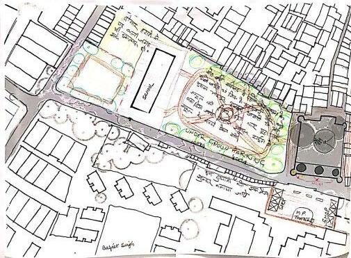
HERITAGE IN NEIGHBOURHOOD
Role of community, History and Culture in shaping the Historic Urban Environment
A Case of Masjid Moth Village


Role of community, History and Culture in shaping the Historic Urban Environment
A Case of Masjid Moth Village

Role of community, Hisory and Culture in shaping the Historic Urban Environment
A Case of Masjid Moth Village, New Delhi
Guided by Nikhil Dhar
Master of Architecture/Masters of Landscape Architecture/ Masters of Landscape Design Faculty of Architecture
May, 2018

Dedicated to my dad who always says this place has some magic and warmth.
I, Monica Chaudhary, the author of the thesis titled H eritage in Neighbourhood: Role of community, Hisory and Culture in shaping the Historic Urban Environment (A Case of Masjid Moth Village, New Delhi), hereby declare that this is an independent work of mine, carried out towards partial fulfilment of the requirements for the award of Masters of Landscape Architecture degree at the Faculty of Architecture, CEPT University, Ahmedabad. This work has not been submitted to any other institution for the award of any degree/diploma.
Monica Chaudhary | PA200416
Date: May 1, 2018
Place: Ahmedabad, India
Disclaimer
This document describes work undertaken as part of the MLA degree at the Faculty of Architecture, CEPT University. All views and opinions expressed therein remain the sole responsibility of the author, and do not necessarily represent those of CEPT University, the Thesis Guide(s), or the Thesis Committee.
Delhi in contemporary times (along with its political and historical identity) is known by its unique quality of integrating its new with its old. The food, the built fabric, the architecture are some examples that give hints of this amalgamation. The integration can be also seen in the most neglected spaces of Delhi, the ‘urban village’.
An Urban village as a phenomenon in Delhi is generally (but not always) focused around a monument which acts as a marker or identity for an area, in terms of character and sometimes the name of the area itself. The Monument, the green patches around it and the old settlements, built with close-knit informality, form an urban village. Along with the rustic street character, the landscape, and the living history, these urban villages bear a rich culture which is endangered these days but do exist around the monuments in form of rituals, fesivities and gatherings. Making these neighbourhoods rich and unique.
The thesis talks about this specific typology of monuments, which is often counted in the unexplored heritage of Delhi. The fragmented pieces of history in the close knit community around it. But unfortunately it has become rather common to see their identity diminishing with time, (encroachment, vandalism ec.) and the new identity overshadowing the past. Considering this and he fact that heritage is important for a city, the thesis also focusses on making the setting stand out and reconnect it with its’ history and celebrate its culture.It challanges 100 m protected area policy, and puts forward a few new considerations for the policy makers to rethink the historic setting in a neighbourhood.
Hence, a new methodology developed for the past and present to co-exist, where the dignity of the monument and the importance of the culture doesn’t overshadow the other, but rather complement it, celebrate it.
Keywords: Heritage, Historic Urban Landscape, Cultural Identity
I would like to express my special thanks of gratitude to my guide Mr. Nikhil Dhar, who believed in me and the topic I chose and supported me throughout my thesis. His involvement and knowledge about the topic was inspiring and I thoroughly enjoyed the whole process of it. I would also like to thank my head of department Ms. Deepa Maheshwari for her continuous support, guidance and reviews to enable me to commit to this project and understand the intricacies of it.
Special thanks to my family for their continuous support, especially my father Mr. Tarsem Chaudhary who helped me with the interviews and keeping up the enthusiasm.
And special Thanks to my friend Pranav Dhawan for building up the topic and humbly helping with the workshop, Harshdeep Arora for his valuable reviews and Lastly, Palak Shah and Veeren Poola who helped me in finalizing the project and outcomes.
Fig.1 Heritage in Neighbourhood
Fig. 1.3 Masjid Moth Village
Fig.1.1 India
Fig. 1.2 New Delhi
Fig. 1.4 Prayer Hall
Fig. 1.6 Eastern Gate to the Masjid
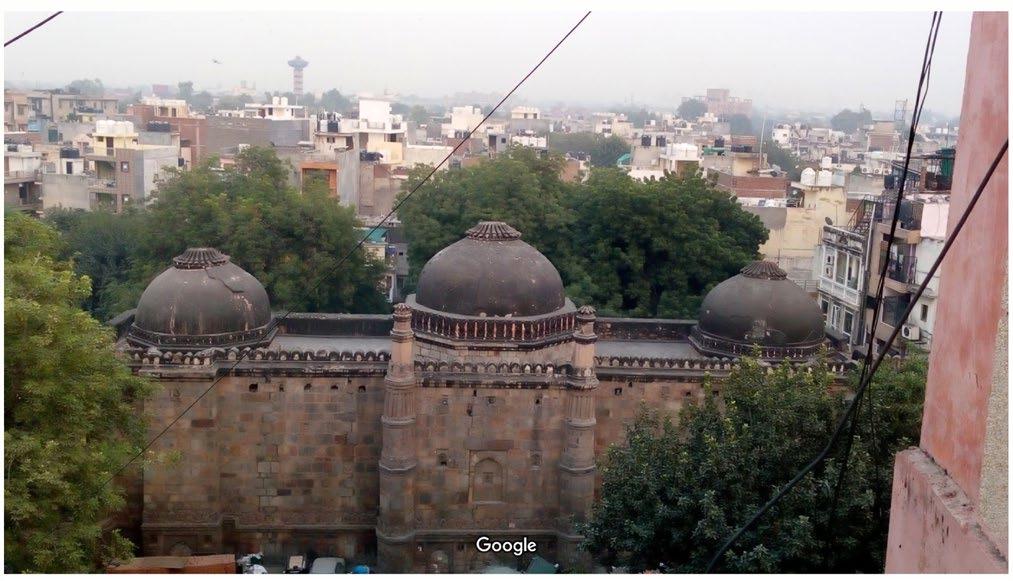
Fig. 1.7 West wall of masjid with it’s eastern context.
Fig. 1.5 Bastion like turret and Chhatri
Fig. 1.8 Vertical Encroachment
Fig. 1.11 Monument Wall as parking
Fig. 1.13 Women interact while drying their clothes
Fig. 1.15 Tight approaching streets
Fig. 1.9 Street Character - Dumpyard
Fig. 1.12 Sai Baba Mandir - New Identity
Fig. 1.14 Men gather around junctions
Fig. 1.16 Holika Dahan on Chauraha
Fig. 1.10 Unknown Tomb
Fig. 1.17 Village Masjid Moth
Fig. 1.18 - Fig. 1.25 Thursday Market
Fig. 1.26 Thursday Market Route
Fig. 1.27 Methodology
Fig. 2.2 Regulated and Prohibited zones
Fig. 2.1 Background Analysis Framework
Fig. 2.3 Kotla Mubarakpur
Fig. 2.4 Zamrudpur Village
Fig. 2.7 - 2.11 Heritage treatment and association with community
Fig. 2.14 - 2.17 Heritage treatment and association with community
Fig. 2.12 - 2.13 Nature of Encroachment - Khidki Masjid
Fig. 2.5 - 2.6 Nature of Encroachment - Shahpur Jat
Fig. 2.18 Demonstration of frequency of the typology in vicinity
Fig. 2.19 Ages of Heritage in Delhi
Fig. 2.20 Historic Footprint in South Delhi
Fig. 2.21 Delhi Drainage 1807
Fig. 2.22 Delhi Drainage overlay
Fig. 2.23 Urban villages of Delhi
Fig. 3.1 Masjid Moth and Sorroundings
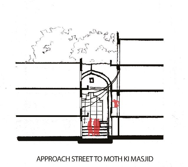
Fig. 3.2 Existing Sections
Fig. 3.3 Demographics Map
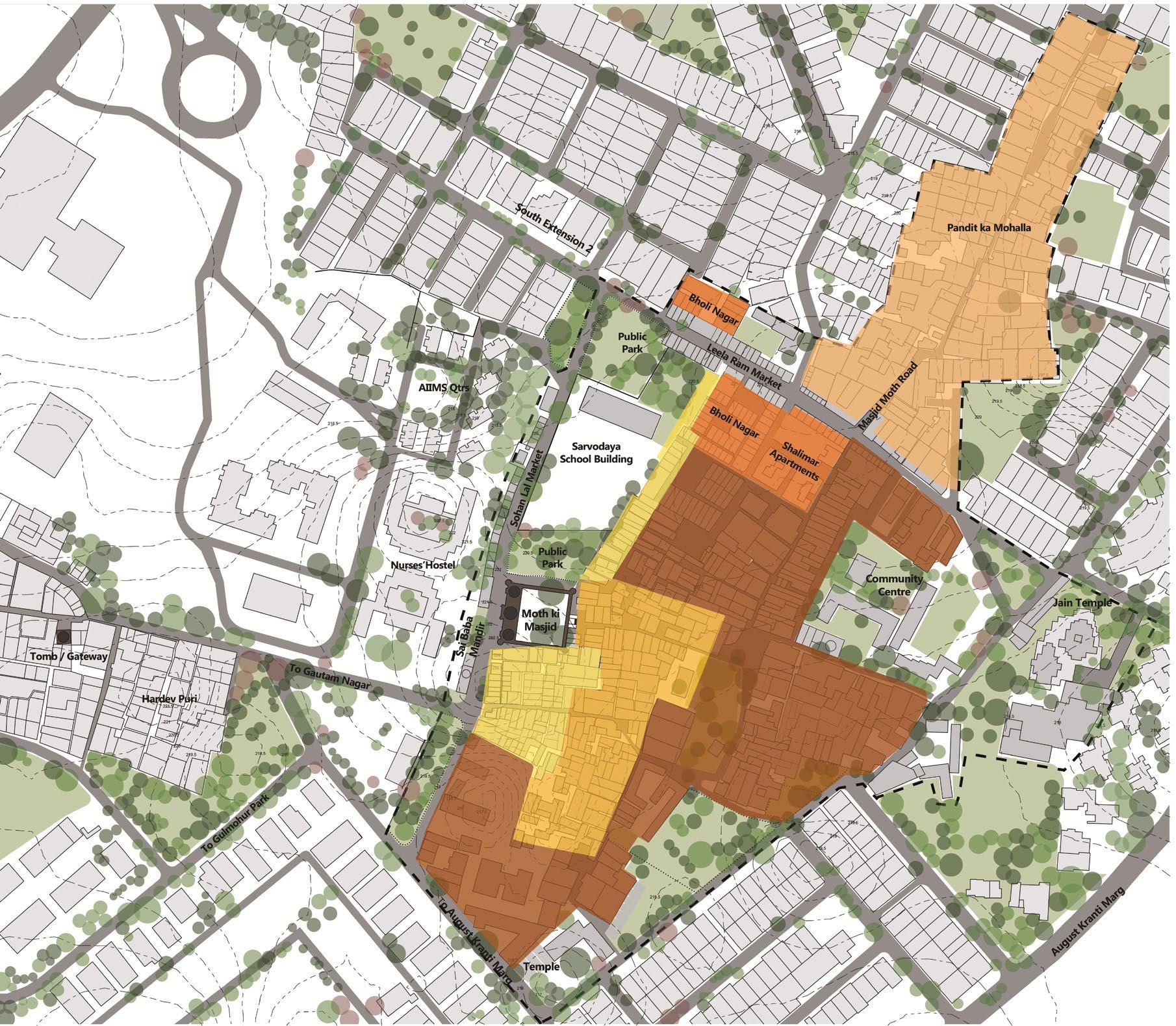
Fig. 3.4 Evolution of Clusters
Fig. 3.5 Culural Network Map
Fig. 3.6 Activity Mapping (Day to Night)
Fig. 3.7 Activity Mapping (Day-wise)
Fig. 3.8 Land Use Map
Fig. 3.9 Building Heights Map
Fig. 3.10 Satellite image 2001
Fig. 3.11 Satellite image 2007
Fig. 3.12 Satellite image 2015
Fig. 3.13 Satellite image 2018
Fig. 3.14 Vegetation Map
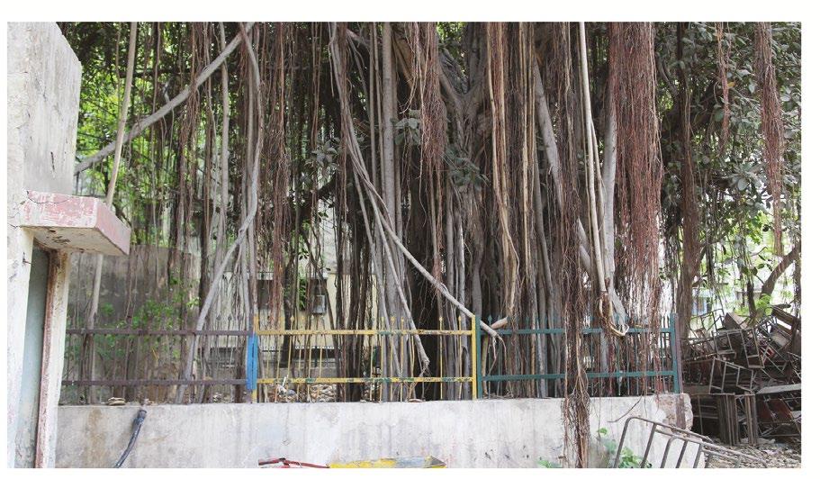
Fig 3.15 Abandoned 100 year old Banyan tree in school Premise
Fig. 3.16 Azadirachta indica plantation in Masjid Courtyard
Fig. 3.17 Street character of approach road to Masjid
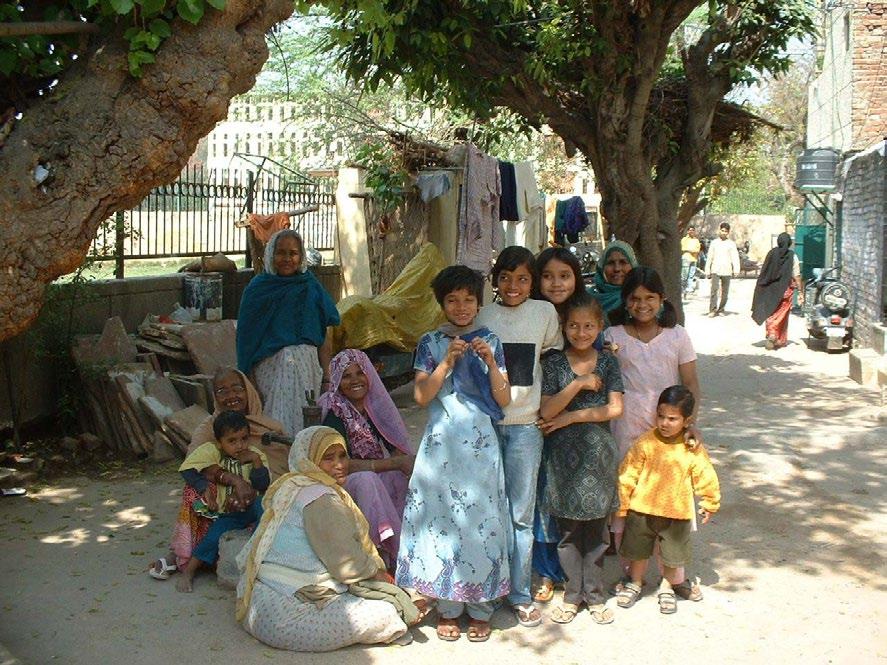
Fig. 3.18 Photo from early 90s showing the Ficus infecoria and Morus alba trees, and people made the shade their place to sit and interact
Fig. 3.21 Green and Open Space Map
(Source : Author)
Fig. 3.21 Network Map
Fig. 3.22 Dilapidated state of streets
Fig. 3.23 Footpaths
Fig. 3.24 concrete streets
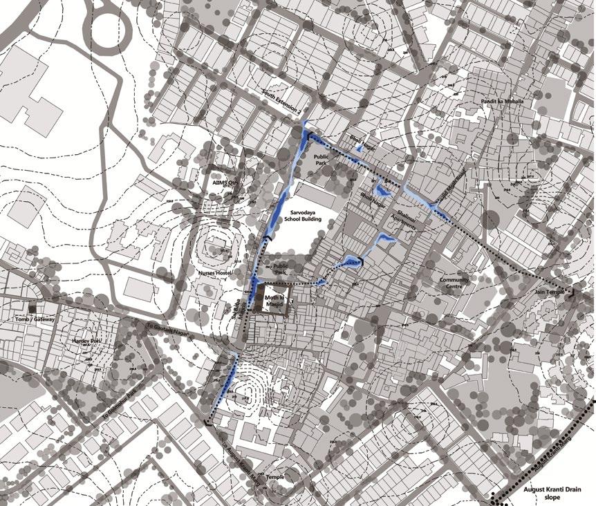
Fig. 3.25 Drainage Map
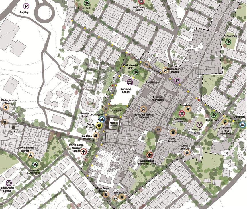
Fig. 3.26 Infrastrucure Map
Fig. 3.27 Views of the monument from around
F ig. 3.28 Views around from the monument
Fig. 3.29 To the northern side street - Parking on the monument wall
Fig. 3.31 From Northern Turret to dumpyard
Fig. 3.33 Approaching Street - Eastern Entrance
Fig. 3.35 Adjoining Street of the mosque
Fig. 3.30 From Top of the roof of Masjid towards Sai Baba Temple
Fig. 3.32 Buildings on the southern side of the monument
Fig. 3.34 View of the Mosque from Market
Fig. 3.36 Approaching road From Market
Fig. 3.36 and 3.37 From Nurses’ Hostel
Fig. 3.38 View from adjoining Park
Fig. 3.39 From Southern side street
Fig. 3.41 and 3.42 Views From Village building
Fig. 3.44 Panoramic view From Village building
Fig. 3.40 View from School Building
Fig. 3.43 From Sai Baba Mandir
Fig 3.47 View of the monument from school terrace
Fig. 3.45 Monument with encroachments; 1963
Fig. 3.46 Entrance to the monument; 1963
Fig. 3.48 Plan view of the village for ideas
Fig. 3.51 Elevational view for understanding and attempt ideas about association
Fig. 3.49 Plan view of the village for understanding the context
Fig. 3.50 Workshop
Fig. 3.52 Issue Matrix and Intensity of issues
Fig. 3.53 Issue Analysis
Fig. 3.53 Association Collage
Fig. 4.1 Location
Fig. 4.3 The lighting retains the mysterious quality of the Gumbad
Fig. 4.2 Low height walls and shrubbery for connection with the church
Fig. 4.4 Visual and direct connection with the surrounding buildings
Fig. 4.4 Plan - Gol Gumbad (Design Moves)
Fig. 4.6 Location - Tomb
Fig. 4.8 Open view of the tomb from settlement
Fig. 4.7 slums around the Bijri Khan Tomb
Fig. 4.9 Disconnection from context
Fig. 4.10 Plan - Tomb of Bijri Khan (Design Moves)
Fig. 4.11 Before and After intervention images of the park
Fig. 4.12 Plan - Community park - Nizamuddin Basti
Fig. 5.1 Synthesis 1
Fig. 5.2 Synthesis 2
Fig. 5.3 Synthesis 3
Fig. 6.1 Conceptual Master Plan
Fig. 6.2 Master Plan
Fig. 6.3 Detailed Plan
Fig. 6.34 Proposed Sections
Fig. 6.6 Forecourt
Fig. 6.7 Northern Wall - Heritage Corridor
Fig. 6.8 Banyan Tree Court
Fig. 6.9 Monument Plaza (Aspirational)
Fig. 6.10 Monument Plaza (Reality)
MPD – Masterplan Delhi
AIIMS – All India Institute of Medical Sciences
HUL – Historic Urban Landscape
ASI – Archaeological Survey of India
NCT – National Capital Territory
ICOMOS - The International Council on Monuments and Sites
INTACH - Indian National Trust for Art and Cultural Heritage
AMASR - The Ancient Monuments and Archaeological Sites and Remains Act
Moth ki Masjid is the name of the medieval mosque located near an upper class South Delhi residential neighbourhood, South Extension II. The mosque is surrounded by, apart from other such residential colonies as Uday Park, Gulmohar Park and Niti Bagh, a dense ‘urban village’ named after the mosque – Masjid Moth. The Mosque has stories fictional, factual and haunted making it unique not just in spatial character and form but also from the spirit of the place.
Moth ki Masjid looks, from the outside, more like a fortification than a place of worship— especially if you happen to be looking at it from the back. This area, with its high, forbidding wall, curved, bastion-like turrets and overall strong character, is so much like a citadel that you’d be forgiven for not realizing it’s a mosque. (Sair ul manazil)
If you go round the surrounding wall, though, you’ll soon begin to see signs of the decoration that makes Moth ki Masjid such a very attractive building. At the corner, the wall is topped with a pretty domed chhatri (a small pavilion) adorned with bright blue tiles.
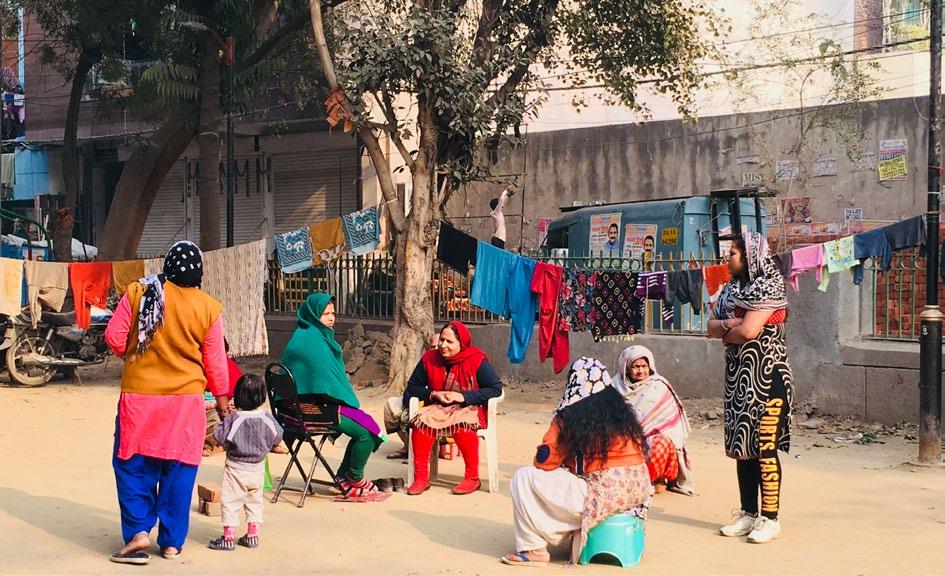
Inside the Masjid as we enter we see a courtyard with two graves together and one apart, and also a tank like structure where birds get fed by people who visit. The four Neem trees presents a shaded open space used for worship once but not so today. Today we see children playing when the sun sets or on a Sunday when the masjid and the guard is busiest, not with the tourists, but the community around. Women sit on the huge and decaying steps of the mosque, interacting with each other and waiting for the vendors to come.
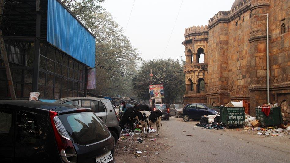
For the tourists, they’re most likely to miss the place as it is not a very popular mosque, rather it is mentioned in the book Invisible City: the hidden monuments of Delhi by Supriya Mukherjee in 2011. But for the ones who visit the huge blue dump yard located right opposite, about 6m apart, from the West Wall of the mosque. It shows another face of the mosque, but not a glorious one.
It seems like people here don’t realise that there’s a monument of historic and national importance (Listed in Archaeological Survey of India) situated within their village, for them it has always been there, like an old neighbour or an old story. The one who has forgotten his real self to dissolve in the colours of today, the one who was once the place of worship but now has given the responsibility to a tiny temple in the corner. What remains is a beautiful skyline and a pause hat the village has inherited.

Delhi can easily qualify as one of the world's most dynamic and complex urban settings in contemporary times. Rightly designated as the capital of the country for decades, several dynasties have given their footprint and made Delhi their home. “Perhaps the unique ecological security provided by the location or it being a vantage point over the plains of Punjab. The ridge and river formed diversity of waterbodies (Ponds, lakes, canals). These waterbodies provided alluvial fertile soil which made Delhi a site for farming” (Urban Resource Group, 2008) some of which still continues to this date though disappearing fast. Rapid urbanisation has given Delhi a dramatic change. The pace of change has been so fast that it is only natural to see many contradictions and its remnants.
One such example of this remnant and contradiction is its ‘urban village’. An Urban village as a phenomenon in Delhi is a settlement originated (mostly) around a monument. This settlement marks the habitation of older times. And the monument acts as a marker or identity for that area, in terms of character and sometimes the name of the area itself. In order to protect the history associated with the place, green patches or open spaces around as a regulatory buffer is given to protect the dignity and integrity of the heritage. As and add on, the old settlements around it, built with close-knit informality, establish the character of a typical urban village, engulfed by the metropolitan infrastructure of Delhi. Along with the rustic street character, the landscape, and the living history, these urban villages bear a rich culture which continues today and make the village unique.
These villages creates their own stories, and have their own kind of association with their monuments. Most of the people don’t know about the history of the monument, but they have their own experiences as stories of their past related to it. These stories, experiences and associations make the enigma of the place or “the spirit of the place” (O’Donnell, 2008) and the thesis focusses on protecting this spirit along with the monument it bears.
Fig.1 Heritage in Neighbourhood Village Masjid MothMasjid Moth village is situated in an elite neighbourhood of South Extension Part 2, New Delhi. The village is named after a medieval mosque, built under Lodi era called Moth ki Masjid. Other colonies in the vicinity are Uday Park, Neeti Bagh, Gulmohur Park and a small qasba (town) called Gautam nagar. One can easily access and locate area through AIIMS hospital which is on the western side of the village along with its’ Nurses’ Hostel and residential quarters.
This village comes under lal dora areas of Delhi which means they are exempted from the building bye laws, and strict construction norms and regulations, as regulated under the Delhi municipal act. There was / is no need to apply for the building sanction plans etc. Hence the development here is random and not regularised, as a result to some extent illegal (Building height, land encroachment). The term Lal Dora was used for the first time in the year 1908. It is a name classification given to that part of the village land which is part of the village “Abadi” (Habitation). “It was supposed to be used for non-agricultural purpose only. It is that part of the land which was supposed to have been an extension of the village habitation, wherein the villagers used to have their support systems, livestock etc.”(Delhi Master Plan (MPD-2021), 2009)
Masjid Moth village was indeed surrounded by agricultural land, which according to folks were tobacco farms. Naturally, before urbanization the main source of earning was related to agriculture but the acquisition of their land for urbanization took away their source of earning and brought a fundamental change in the source of livelihood in the village. “The village has been losing its agricultural land to meet the housing demand of urban Delhi since the 1950s. South Extension II, built entirely on the land of this village during the 1950s and the1960s by the Delhi Land and Finance (DLF) Ltd. a real estate developer, now forms frontage of the village in the north.”(Mehra, 2005) Today no piece of agricultural land remains and Masjid Moth village exists as unplanned dense urban fabric amidst planned and regularised neighbourhood of south extension.
Coordinates - 28°33'45.27"N, 77°13'3.86"E
Area - 1,600 sq.m.

Area of Village - 72,000 sq.m.
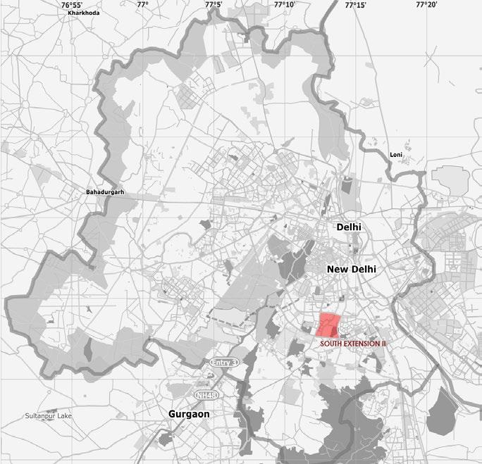
Moth ki Masjid or Masjid Moth village is located in the Southern part of Delhi and is well connected through various modes of transportation, and can be reached by either Delhi-Mehrauli road by the side of Yusuf Serai or from the Ring Road through the colonies of South Extension. Masjid Moth is surrounded by residential areas and wo commercial edges namely Leela Ram Market and Sohan Lal Market. Nearby areas are Siri Fort, Hauz Khas, Green Park, Defence Colony, Lajpat Nagar and Kotla Mubarakpur.
Nearest Airport: Indira Gandhi International Airport

Nearest Railway Station: Nizamuddin Railway Station
Nearest Metro Station: Green Park (Yellow Line), South Extension (Pink Line)
Bus Stop: South Extension 2
(Mosque Timings: 9 AM to 4.30 PM (Open all days)
Moth ki Masjid, translating to "Lentil Mosque," was built in 1500s by Miyan Bhoiya, a prime minister under Sultan Sikander Lodi (reg. 1489-1517). “It is said that the mosque was built from the proceeds of the plentiful harvests reaped from a single lentil that Sikander Lodi had found at the Friday mosque and presented to Miyan Bhoiya in jest.”(Aga Khan Trust for Culture, n.d.)
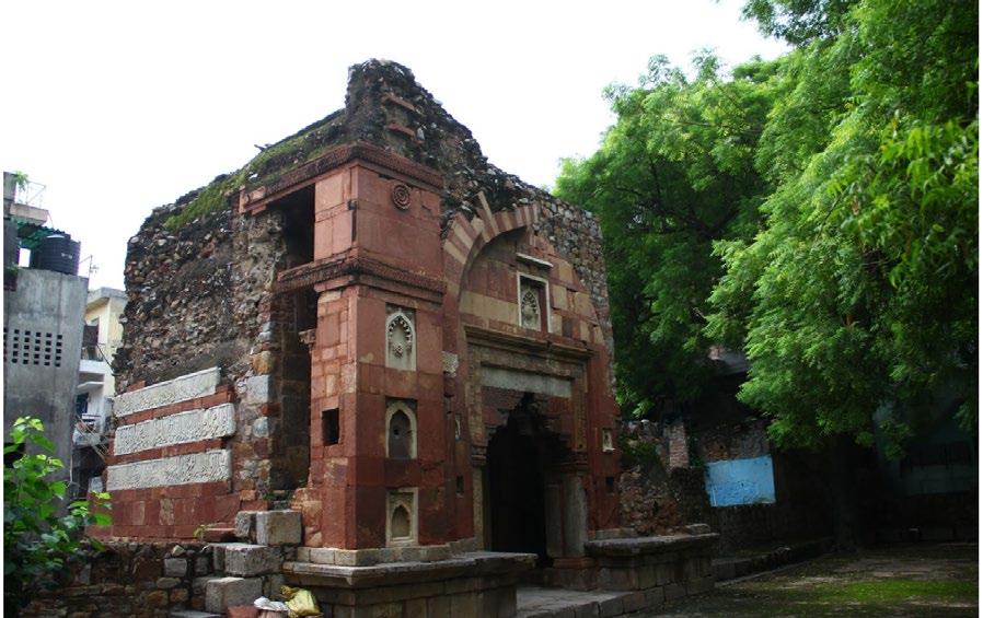

This mosque is considered the second example, after the Bara Gumbad Mosque at Lodi Garden, Delhi, of the new mosque type that developed during the Lodi period. Characterized by a smaller size, a more intimate scale, and intricate ornamentation compared to the large congregational mosques built during earlier sultanate dynasties. Its variant name, "Panchmukhi Mosque," refers to the five-bay arrangement of the prayer hall. “This mosque served as a model for the Jamali Kamali mosque at Mehrauli, Delhi, built between” 1528 and 1536. (Peck, 2005)

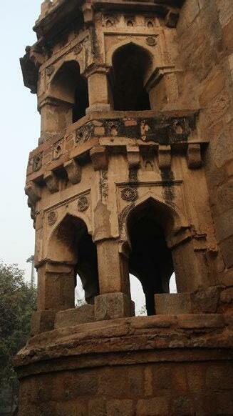

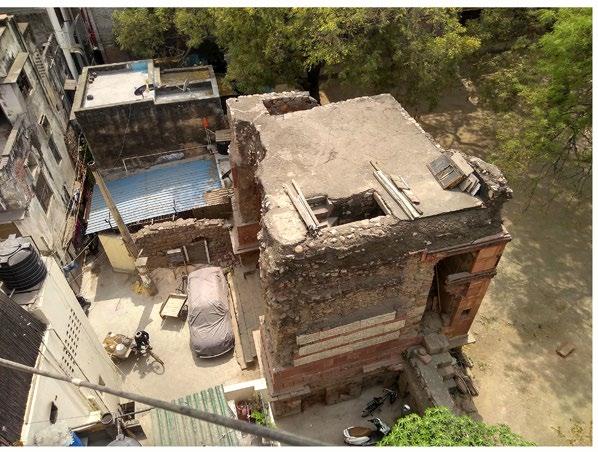
As discussed, Moth ki Masjid although a worship place, the citadel like appearance gives a general air of solidity to the whole village. Encroachment on the southern and Eastern side shows the decaying nature of the site, could be called the footprint of contemporary times. The encroachment is also vertical, and the material used in a few buildings dissolve the effect of the monument.
Images Source:Author
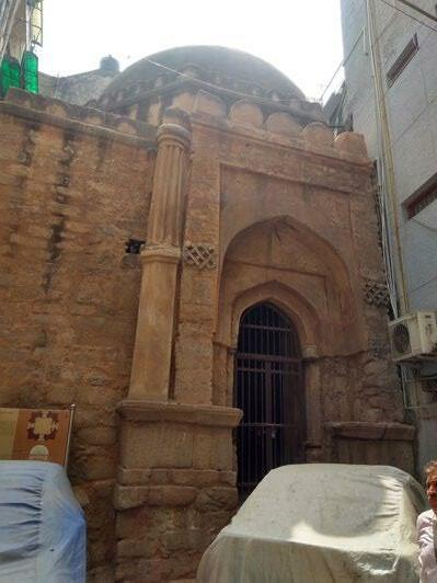
The area around doesn’t correspond to historic nature of the site. Although the monument has religious significance, but Namaz not been read here for 50 years and with no Muslims in the community, the area has developed a very different character, usage, culture and an interesting identity with time. This makes the visual character of the whole area very unique.





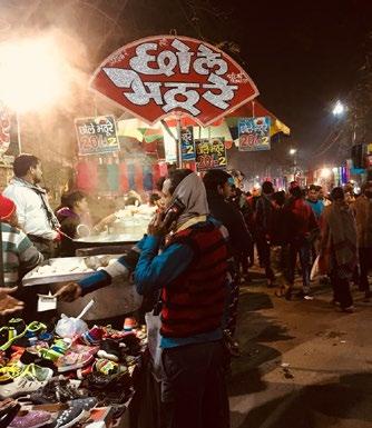
“These markets represent a history, a tradition and a cultural continuity”(Sohail Hashmi, 2007)
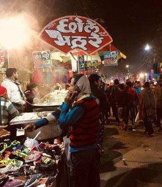
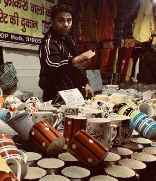
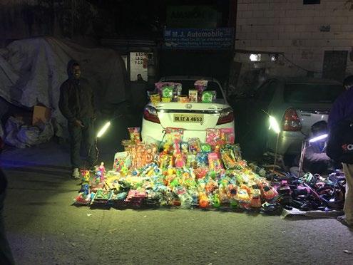
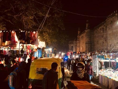
Weekly bazaars are one of those lesser known trends which is not really an attraction for tourists but a basic necessity for people living near it. As per villagers of Masjid Moth, these bazaars got an official permission to set up their shops near urban villages in 1980s.
In older times, Delhi villages were enclosed within walls or fixed boundaries and the means of transport were few, for buying their basic necessities they used to rely on weekly haats or bazaars. Weekly bazaars were a series of makeshift shops who used to set up a market near villages day wise, so on Thursday if you the market would happen in Masjid Moth, on Friday it will happen at Zamrudpur (another village).
This tradition continues today as a trend near Some urban villages in Delhi and in Masjid Moth on Thursday. For this particular day, every week, the village transforms itself to veer bazaar. From morning to evening, the gradual transition is an interesting phenomena to observe. The west wall of the masjid act as a backdrop to clothes market, whereas vegetable market extends to Leela Ram Market and home necessities to Gautam Nagar.
The bazaar brings back the old tradition, yet another heritage but with the fast growth of Delhi they seem to have become obsolete. No so for people of the village, for them their convenient market to stock up weekly necessities, is under threat.






 Heritage in Neighbourhood
Fig. 1.18 - Fig. 1.25 Thursday Market
EVOLUTION OF PLACE AND COMMUNITY
(Retain or bring back the spirit of the place)
Historic / Cultural Landscape
As Urban Place
People, Place, Time
Defines character of the city, town or village
Need for a new perspective on Historic Urban Environment. Preserve the value embed in inherited townscapes. Retain heritage value through built and natural layers. Involvement of Community and culture o transform the landscape
• Against the backdrop of global and on-going transformation in urban and urbanizing areas, can the places of urban heritage reconnect to the city and community through landscape?
• Should the built layer be considered with the natural layers for preservation? What is the importance of natural layers of heritage?
• Considering the current context, what are the measures that can be developed to guideline the future development?
• How can the association with monument re-established within folks for them to realise the history and richness of their place.
• Can a single policy work for all the monuments, what are the heritage policies that can work for heritage with an urban village to bring back the spirit of the place.
• If a new method of designing historic environment be developed which involves the community (and children) and culture to show not only the tangible but also intangible values associated with the monument
The intent of the thesis would be to take an urban village (Masjid Moth village) which originated as a settlement around a monument, study the layers of history, geography, culture and community in depth to understand this urban landscape typology. Identify, analyse and present the heritage value of it to add a new layer of intervention which hence shape the landscape of an urban village. This will involve community participation as well to redesign the whole area. This village can act as a prototype to define parameters for other urban villages to re-imagine their landscape according to their context.
To reimagine the regulatory buffer around monuments of specific typology taking in consideration the association of community and the historical, cultural, economic and environmental aspects.
• To study the immediate and broader context of monuments and urban villages surrounding them, and understand how these are interdependent through times and how they work as a system
• To study the evolution of heritage landscapes and the issues
• To study the spirit of the place in order to understand the setting holistically.
• To reimagine the growth pattern of urban village in order to redevelop the connection with history and identity that is lost.
• To suggest / design mitigation measures for creating a sustainable and timeless heritage environment
• Define a set of parameters for areas to re-imagine their landscape according to their context for sustainability.
• INTRODUCTION OF THE SITE – VISUAL ANALYSIS
• Evolution of Delhi through ages (Heritage history)
• Premise – Issue Analysis INTRODUCTION
• Frequency of monuments in South and South-west Delhi (Mosques and Tombs in Social Context (Defining the scope)
• Identifying the similar typology and marking the historical footprint on the area
• Traditions and settings related to Masjid – Historic Perspective
• THE NEW URBANISM – understanding the keeper of the monuments through case studies
• Introduction of Moth Ki Masjid – The monument and its community (PHYSICAL ANALYSIS)
• Landuse, Pattern, Clusters
• Connectivity, Road Material
• Vegetation
• Drainage, Topography
• Infrastructure
• Bye-laws and Policies
• Building Heights
• Spatial Character
• Culture and Spirit of the place (SOCIAL ANALYSIS)
• Demographics
• Activity Pattern
• Cultural Networks
• Rituals, Worship, Festivals
• Story / Memory of past events
• Gatherings Places
• Iconic Shared Community Place
• Demonstration on site and Landscape Character Assessment (COMMUNITY PARTICIPATION)
• Analysis and Synthesis Maps to draw inferences and Conclusion
• Why control matters (CASE STUDIES)
• Sensitive zones and issues (Through synthesis maps) for Policy design
• Considerations and Strategies for creating a program
• Program (Designing the buffer zone) for Historic and cultural environment (How can it aid the character and well being)
• Application of results on broader context
• Final strategies (Design) for the area
• Implied parameters for designing the similar typology
• The study limits to the monuments present in the in the close knit environment of urban village, Masjid Moth being an example. The policies related to it and the overall character and evolution of the place.
• The study is conducted limited to monuments of a similar typology and era before Shahjahanabad (Before 16h century AD) which is concentrated in South and South-west Delhi
• It takes into the consideration the built that has already happened and now what measures can be taken to bring back the historic environment.
• It also talks about the natural layers which could have been preserved and create a vision about how the scenario could have been in present.
• The design would involve suggesting new policies for heritage management and character development of the place and redesign the green patches, street and chauraha.
• The study would suggest the importance of heritage in vicinity and small demonstration could help in awareness amongst stakeholder about how it can work in favour village in terms of economy, social interaction, aesthetics and healthier environment.
• A set of parameters and guidelines for development around heritage in urban village in order to retain or bring back the spirit of the place.
• A design intervention that could help re-establish the association of community and culture with the historic site.
• Categorise, analyse and present heritage value of the area, and hence the design intervention.
• New policies for heritage management.
• Flash and tactile interventions that can open new opportunities and ideas to design such environment.
Following are the key aspects to be considered for the background research in order to get the in-depth information about the issue and ways that can facilitate them.
• The issue of encroachment faced by monuments of Delhi, the typology and reasons.
• History and heritage of Delhi - Its evolution and natural layers, Historic Footprint
• Moth ki Masjid - Historic evidence, Listing and importance
• Understanding Urban Village as a system, Historic Setting,
• CPWD guidelines
Issue of Encroachment
Identification of Typology
Case examples
Monuments in Vicinity
BACKGROUND
Evolution of Delhi
Natural layers
Historic Footprint on South Delhi
History and Importance
Listing
Urban village as a system
Historic Setting and analysis
Guidelines for Conservation
According Cambridge Dictionary the word encroachment means the act of gradually taking away someone else's rights, or taking control of someone's time, work, etc.
Regulated Boundary
ASI Prohibited Boundary
Moth ki Masjid
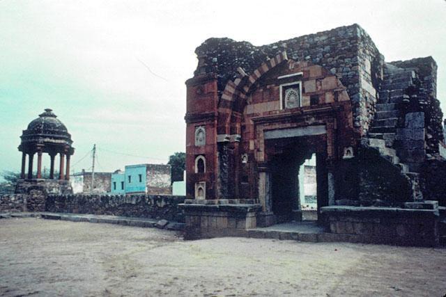
Unknown Tomb / Gateway
Archaeological Department Protected Boundary
Source: Author, Information Source: ASI, Delhi Chapter Fig. 2.2 Regulated and Prohibited zones
“
In a historic setting, ASI and Department of Archaeology, NCT Delhi prohibits any development within 100 m and 50 m respectively of a listed monument. The Ancient Monuments and Archaeological Sites and Remains (Amendment and Validation) Act, 2010, ensures that no permanent or semi-permanent constructions come up within this prescribed distance. These permanent or semi-permanent constructions are Encroachments.” (Constitution of India)

According to many daily newspaper articles, who have written about the encroached state of monuments today have wrote about how the mushrooming buildings around them, several structures from the Lodi and Tughlaq period being in shambles and some unidentified tombs being turned into even shelters poses a risk on our heritage. A tour around the city reveals the miserable state of these Invisible Monuments and due to the encroachments, it becomes a onerous task to even locate them
The residents don’t even know that the 16-century state-protected structure exists in their midst. Residential buildings encircle it tightly, making it impossible to spot it. Although A pile of rubble and some step ladders hint at some renovation work, a guard seated next to this activity said: “This place used to be inaccessible. One had to climb the grills of a private property to see it. But renovation has started here since the past three months.” (Mitra, 2015)
Even with the Archaeological Survey of India (ASI) and the state protecting 174 and 33 monuments respectively, many of Delhi’s heritage sites still suffer with encroachment or neglect.


“Buildings come up right next to them and there are not even boards describing their significance,” says Rakshandha Jalil, the author of Invisible City: The Hidden Monuments of India. “They become home to squatters and drifters, who are hostile to outsiders. Kabadiwalas store their rubbish and the worst part is the civic agencies couldn’t be less bothered.”
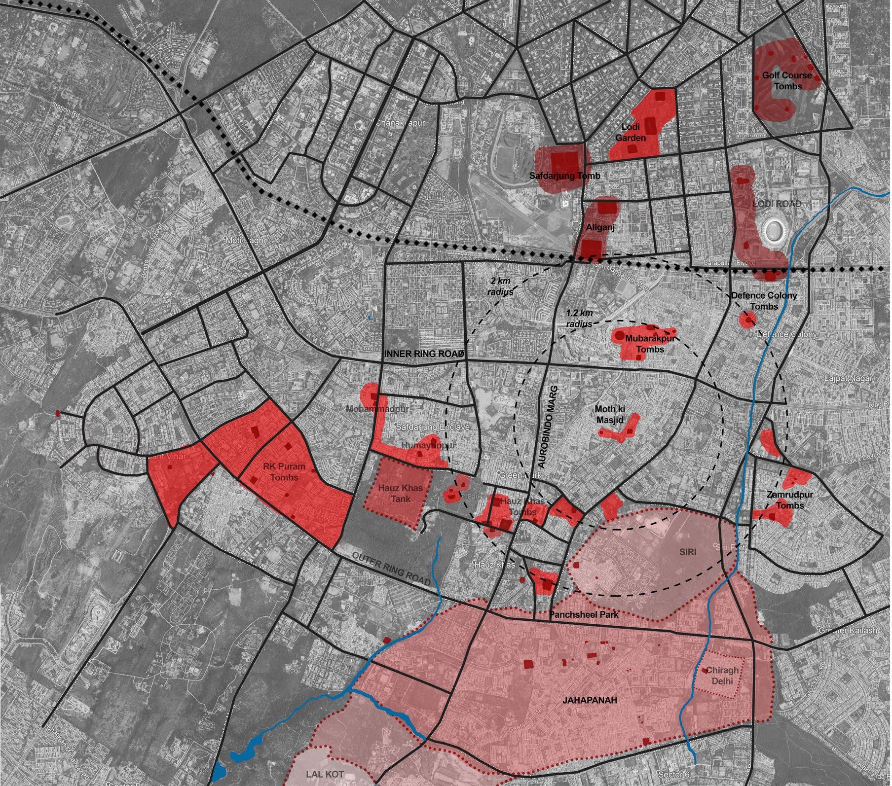
Some case examples which describes the issue of encroachment are Zamrudpur Village, Khidki Masjid, Siri fort wall, Shahpur Jat, Hauz Khas Village, Kotla Mubarakpur and Mehrauli. Two of these examples are mentioned in the following matrix, showing the nature of encroachment, heritage treatment and association of it with the community
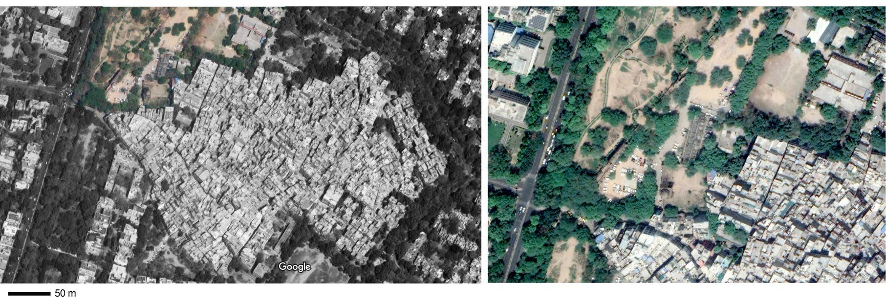
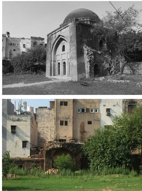


The above mentioned case examples define a specific type of historic landscape or phenomena typical in Delhi. Here the community and the village has a direct or indirect connection with the monument and the regulatory buffer (heritage greens) that these monuments possess has been altered according to the usage of the neighbourhood that this monument bears.
Categorising these monuments into a specific typology where a monument is enclosed by an urban village and the regulatory buffer being used by the village are marked in the map below. (Demonstration area)

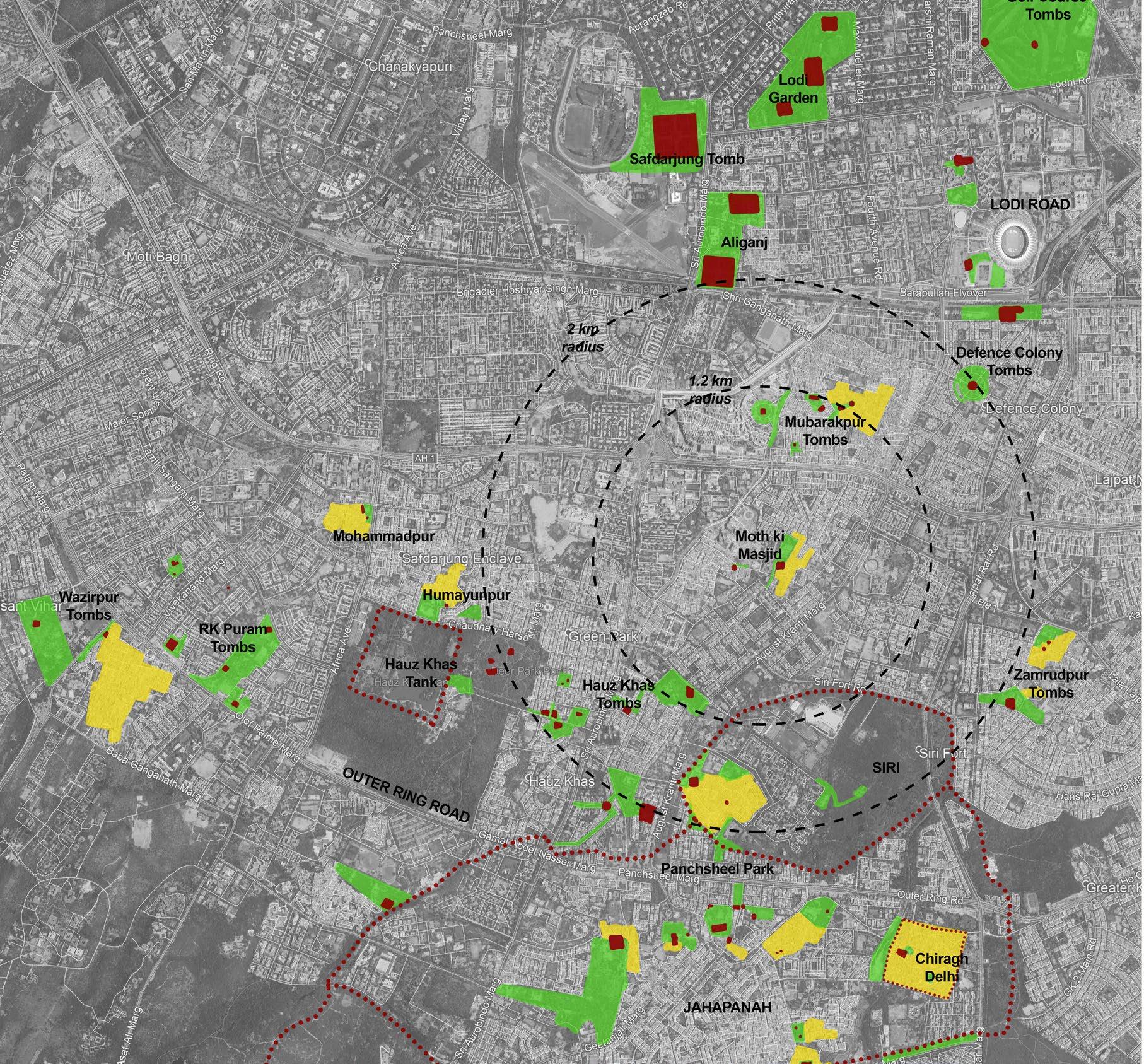
Inference: Even though the issue of encroachment is old and huge for monuments, and definitely it needs to be resolved in order to protect the dignity of the historic structure, but in a fast growing city like Delhi where the development has taken place in various layers, what could be the possible solution of encroachment. Especially where sometimes these intrusion also give a sense of a place to the otherwise, built for tourists, kind on structures.
So, when encroachment is not just physical but social as well, what are the kind of layers that needs to be removed and what the ones that need to be retained. In order to recover the state of the monument, the careful judgement of what intrudes the character and what adds to it need to be examined and analysed.
Each monument needs to be treated as unique, single policy of 100m might not work for all the monuments, especially of the typology, where a monument creates a contemporary neighbourhood.
Delhi had took (a controversial) step forward in being a deserving nominee for the UNESCO’s World Heritage City with around 1200 listed historic structures. And in the bid were counted ever so famous Shahjahanabad and Lutyens’ Delhi. They bring the pride and character to the capital of the country. Other famous ones being Nizamuddin and Mehrauli area. Bringing the focus to the southern part of Delhi which is also not devoid of the historic footprint.
The earliest known urban settlement in Delhi, aside from the mythological Indraprasth, called Inderpat by Sayed Ahmad Khan in his Asaar-us-Sanaadeed (1865) and by Bashir-ud-Din Ahmad in his Waqiyat-e-Daar-ul-Hukumat Dehli (1920) (probably to go well with Maripat, Sonipat, Panipat and Baghpat), is believed to have been at or near the present day Mehrauli. (Sohail Hashmi, 2007)

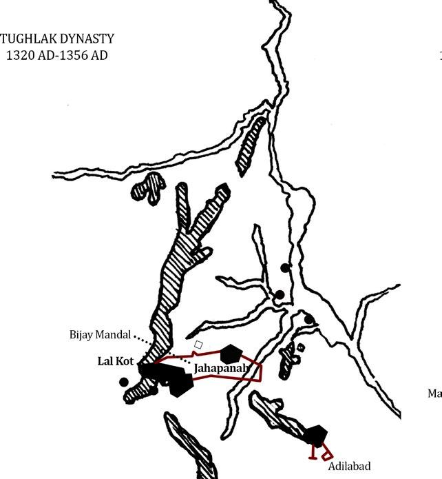
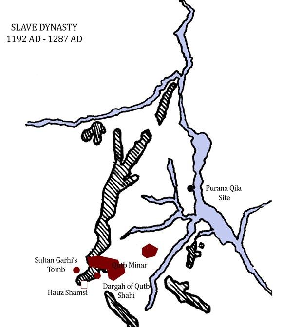
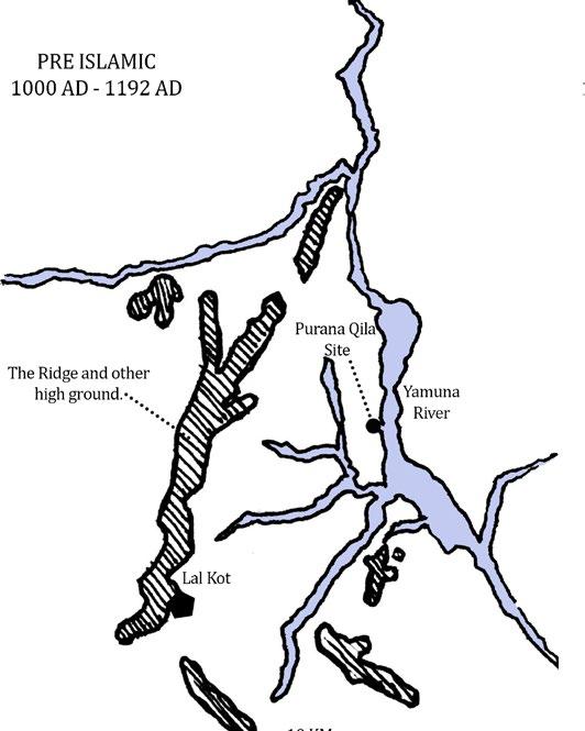
(Source: Author)
(Information Source: Lucy Peck)
The presence of various structures and ruins, both secular and religious, give a hint of rigorous building activities going back to pre-Islamic era to the Colonial era in this area of South Delhi. The Quila Rai Pithora, Hauze-Shamsi, Jamali Kamali Mosque, Rajon ki Baoli and many structures of Kotla Mubarakspur are evidence of a thriving settlement back then. The glorious footprint of history that South Delhi bears and the list of many of these fragmanted heritage been conuted in the less discovered heritage of Delhi. (Refer Fig. Historic Footprint in South Delhi)
Delhi’s topography is a resultant of two main features –The ridge and the river (Yamuna).


These are the only two natural possessions for the city and only refuge areas for the city and hence efforts are being made the most to protect them. Although the development rate has polluted both of them and made many natural channels vanish under them, it has become rather difficult to recover them.
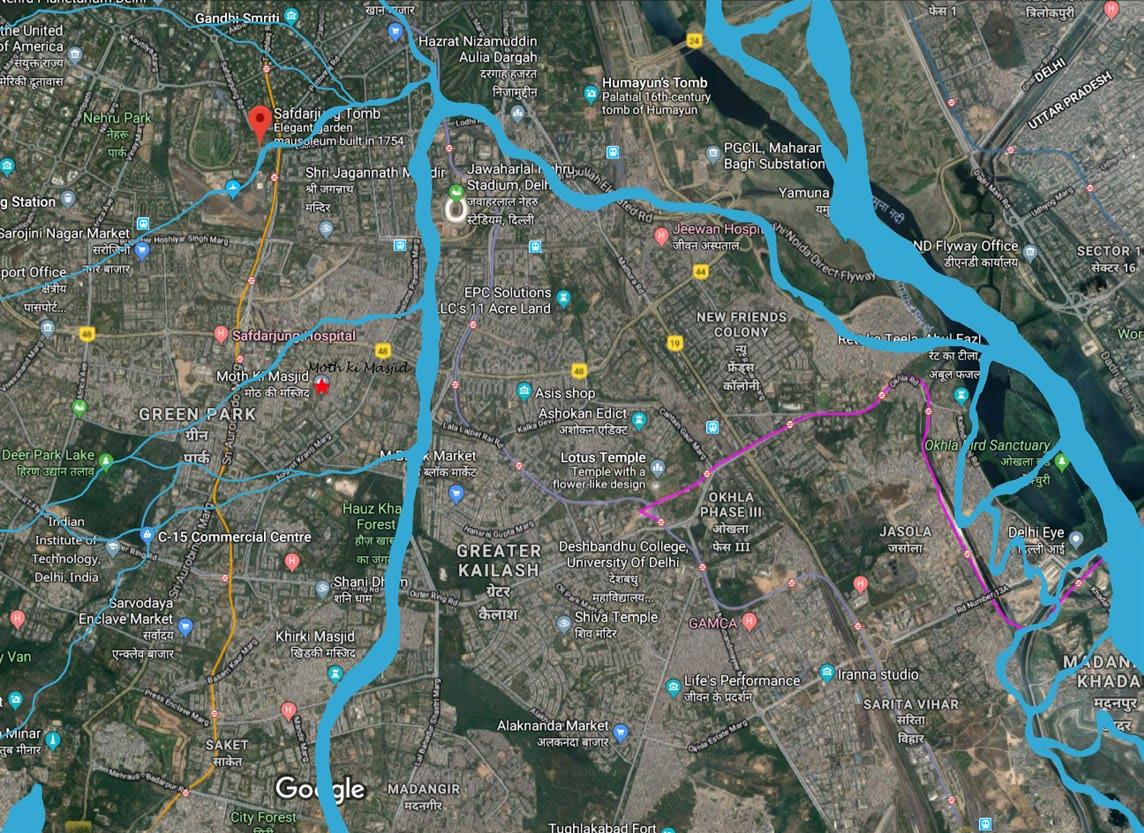
It is ideal and necessary to study these natural layers of Delhi in order to recover as much as possible for the sustainable and natural development of the area. An archival map which shows the natural drainage pattern of 1800s overlaid with the Delhi map of 2018 to study the natural channels that have been lost in order to recover them.

Fortunately, Moth ki Masjid and the village doesn’t lie on any natural channel, hence the mitigation measures are not required for this case.
(Refer Fig.2.21 and Fig.2.22)



Moth ki Masjid - Archaeological Survey of India Listing Grade 1(A)* (Refer Appendix 1)
Unknown Tomb/Gateway - Listed under Department of Archaeology, NCT Delhi
District: South Delhi
Tehsil/Sub Division: Hauz Khas
Topographical Features: It lies in the plains west of the River Yamuna
Ownership: Government
Is it Under Religious Use: No
Administrative Control: Archaeological Survey of India, Delhi Circle, Delhi
Tourist Footfall - 2 people per week
Not ticketed
Information Source: INTACH, Delhi Chapter
This mosque was built near the grave of Mubarak Shah, the second Sayyad King of Delhi, in the reign of Sikander Lodi and in the year 1488 AD. a large mosque was also sunk close to the mosque (rumoured to be in the school land), and an inscription was put in it on red sandstone, which has suffered from efflorescence and of which the following is a translation in English: -
(This) Mosque in the reign of... Majesty.. Sultan [like] Solomon, (Si)kander Shah, son of Bahlol Shah Lodi, may God perpetuate his reign...
(Si)kander..
The gateway of this mosque, which Syud Ahmed Khan believes was a very remarkable building, is now in a state of decay. (Fig.1.10) Tradition gives a very curious account of the origin of the name of the mosque. It is said that one day Sultan Sikander saw a grain of moth (lentil) lying in the Jami Mosque which he held up and handed over to his wise and sagacious minister Miyan Bhoiya, who took it as a great gift from Sikander. The minister thought as the grain had the honour of being touched by the emperor, he must sow it in the orchard of his house. The plant which grew from it yielded more than 200 grains and multiplied in next few years. The money from the harvest was spent to build this magnificent mosque and hence was called “Moth ki Masjid”
Information Source: Hashmi, A.A. (2004) Inventory of Monuments and Sites of National Importance (Vol. 1. Part 3) Delhi Circle, ASI Stephen Carr, (1876) The Archaeology and Monumental Remains of Delhi, Mission Press: Ludhiana
Author:
Mehra, A.K.Background: In Evelin Hust and Michael Mann (eds.), (2005) Urbanization and Governance in India, New Delhi: Manohar, pp. 279-310.
Keywords: Urban villages, urban sprawl, urbanizing villages, policies, lal dora area
Overview:
• The article establishes the phenomenon of urban village and urbanising village in Delhi and the normalisation of acquisition of agricultural land to build the urban settlement.
• It also talks about the various factors that led to formation of such areas, and what are the issues faced by people and character of the area.
• It highlights the lack of governance faced by these areas, hence the character and security degradation.
• The study seeks to examine economic, social and policy consequences of the unique urbanization process in Delhi that has reduced most of the villages inducted into metropolitan Delhi into slums.
• The need for commercialisation of certain areas within built space as a natural tendency.
• Along wih the three case studies of different Urban villages it gives in detail the formation and evolution of masjid moth village.

Fig. 2.23 Urban villages of Delhi
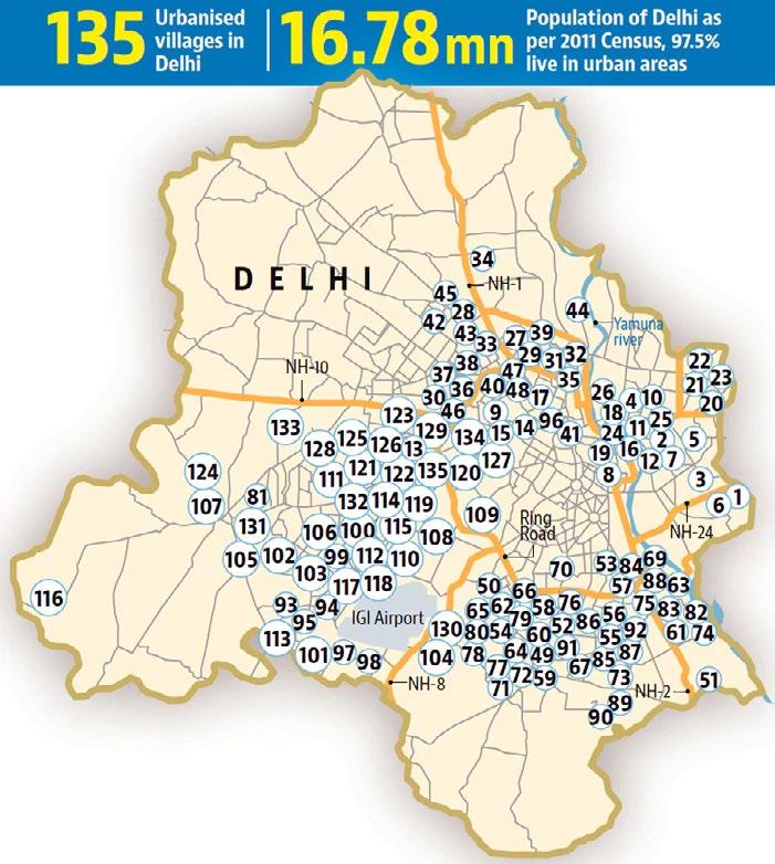
Source: How Delhi’s urban villages turned into ‘no plan land’, Hindustan Times, 2018
• The formation and development of an urban village affects the kind of treatment on the heritage present in it.
• Special governance and management schemes that needs to be designed will be beneficial for the historic environment as well.
• How the village gets its identity from it’s past, and this past is essential to retain.
• For planning a lal dora area one doesn’t need to to only plan the physical structure but also its relation to economic, social and historical structure.
Author: Sipra Mitra, ADG, Architecture
Background: Mitra, Sipra. (2013) Conservation of Heritage Buildings - A guide. Central Public Works Department: New Delhi
Keywords: Listing, Cultural Landscape, Heritage Conservation, Historic integrity
Overview:
• The book highlights the need of categorizing hisoric context into ‘economic’, ‘cultural’, and ‘environmental’ percepion in order to understand it better, although they are not mutually exclusive and, indeed, they are often interlocked. And his complexity needs to be taken care of while conserving a setting
• The book also brings out the three key concepts need to be understood in order to judge if the property is worthy of listing as a Heritage. The three concepts are “Historic significance, Historic integrity, Historic context.”
• Basic understanding of conservaion is also discussed in about what “Heritage Precincts” means and which includes any space that “requires conservation and /or preservation for historical and / or architectural and/or aesthetic and/or cultural and/or environmental and/or ecological purpose.”
• Basic definitions of terminology one needs to know before going forth in the topic of interest.
Inferences:
• Heritage is archaeological sites, remains, ruins, and monuments protected by the Archaeological Survey of India (ASI) and other state archaeology departments and Heritage also is a large number of unprotected buildings, groups of buildings, neighbourhood, and public spaces including landscapes and natural layers which provide character and identity to cities.
• For a Landscape architect to conserve a historic setting it is important to take into account both the protected and unprotected components of the heritage.
• Preservation and conservation techniques, that could be thought upon critically, if the conservation measures should be generalised or specific.
Writer: Navin Piplani, conservation architect and principal director, INTACH
Background: Piplani, Navin. (2018) Section Analysis. Hindustan Times: New Delhi
Keywords: Protected Boundary, Prohibition law, Heritage Bye-Laws
Overview:
• The article is written as a critical analysis of the amendment enforced in 1958 law of 100 m prohibiton around the protected monument*, which now permits construction for public purposes.
• The author does no take a for or against side of the amendment, but talks about the pros and cons of it and the rampant ignorance heritage has been facing from the government.
• The blanket rule of 100 m does not work for all the monuments because each case is unique and representsspecific culture and merit of the site.
• The author also suggested the heritage by-laws for centrally protected monuments to be prepared, with consultation of experts, and enforced to ensure heritage-led development.
• A new kind of development model should be ideally prepared one that is not “rampant, invasive and destructive, but sensitive, responsive and inclusive” (Piplani, 2018) needs to be adopted. With this methodology we can hope a development which is heritage-led, and not real-estate driven.
• The one rule applies for all system should be critically analysed and he methods of smarter conservation should be adopted which have some standards of design creativity, heritage sensitivity and peoples’ involvement.
“The Ancient Monuments and Archaeological Sites and Remains Act 1958 (or AMASR Act) is an act of parliament of the government of India that provides for the preservation of ancient and historical monuments and archaeological sites and remains of national importance, for the regulation of archaeological excavations and for the protection of sculptures, carvings and other like objects.”(ASI, 2013)
Essentially the site needs to be analysed through following three criteria for the holistic understanding of the site
Physical Layers
It is the “tangible values” of the site which includes the physical history, Landuse, Morphology, Connections, Material used for new construction, vegtation and type of open spaces, Water systems and Infrastructure
Social Layers Community Involvement
The “Intangible values” of the site to understand the demographics, the culture network, usage of the area, activity pattern and basic essence of the site to understand “the spirit of the place”
To know the association of people with the landscape they live and work in and also the issues they have with the current scenario to attain their aspirational and conducive neighbourhood.
The analysis gives those values and aspects that makes a unique character of the site, and needs to be considered for a creaive and sensitive design
Further, the case studies chosen are according to a similar context and conditions to critically analyse how they work (or not) and what methods have been used previously for the specific context
Synthesis of analysis to bring forth the issues that needs solution, aspirations of bringing back the idenity and sensitive approach to consider critical zones that are important for the culture of the place.
Lists down the parameters as learnings from the methodology followed to further apply on the bigger issues and could act as the guidelines for designing the site of this specific typology.


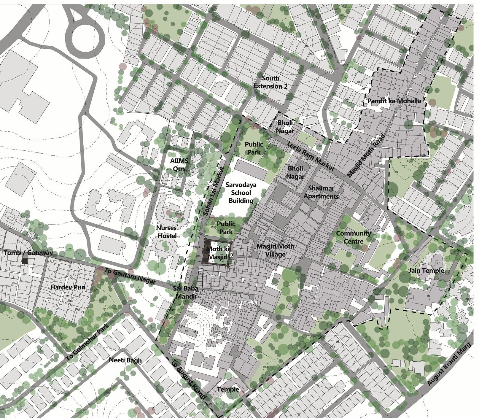
The village has some typical components of an urban village which includes congregation at markers like temples, chaurahas and coutyards, informal usage of spaces and irregularwidths of the streets. It also shows the unplanned development, building heights and the intensity of encroachments.

SECTION A-A


SECTION B-B (a)

(Source : Author)



Masjid Moth village got its name from a mosque, but interestingly today no muslim community lives in the vicinity. According to the census 1991 and Ajay K. Mehra in his book urban villages of Delhi mentions about the various non-muslim communities living in the area from 1930s and that is the oldest data which mentions about the communties in the village. According to people of Masjid Moth Namaz has not been read in the mosque for more than 60 years
POPULATION - 12,000 (6 Polling booths)
6,500 (18+ years) ELECTION OF 2014
459 houses x 4 floors (Avg.) = 1,800 household
GENDER RATIO


820 Girls in 1000 Boys
OCCUPATION
Shopkeepers - 10 % Rental income - 70 %
Labour - 5 %
Self employed (small business) - 15% Service Class - 40 %
Brahmins Harijans (Converted Christians)
Punjabis Sainis
Baniyas
(Source : Author)
Scale

THE SHIFT IN OCCUPATION - The main source of earning for the villagers before urbanization was trade and occupation linked with agriculture. Naturally, the acquisition of their land for urbanization took away their source of earning and brought a fundamental change in the source of livelihood in the village.
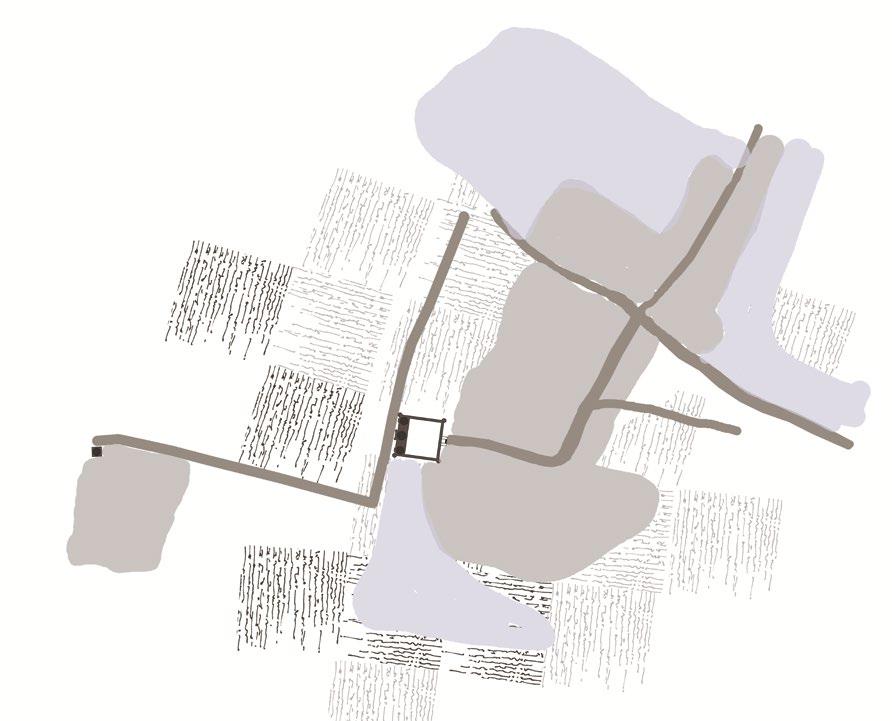
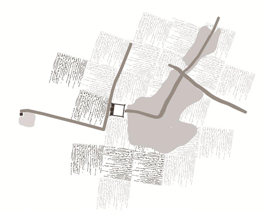

The main source of earning for the villagers before urbanization was trade and occupation linked with agriculture. Naturally, the acquisition of their land for urbanization took away their source of earning and brought a fundamental change in the source of livelihood in the village.
1930s Tobacco Farming around Moth ki Masjid. Sainis and Baniyas lived in the village with around 298 acres of Farmlands. The two monuments had a clear connection, probably that’s why the unknown structure is called gateway to Moth ki Masjid
Early 1940s The Sharmas, who came from Rajasthan, owned bulk of land in Masjid Moth. Many villagers leased land for cultivation from them and in return gave some amount of the yield to them. This areais calledPandit ka Mohalla today. Harijans started residing around monument in kachcha houses.
Late 1940s After the Partition, a chunk of land was given to Punjabis from Pakistan as a refuge. Today it is knowwn as Bholi Nagar or Punjabi colony. A new town much organised established called Gautam Nagar and Hardev. This town Encroached the unknown Structure today. DLF acquired land in Masjid Moth in 1962 in order to develop residential quarters for government servants
1970s By this time mostly all the farmland got acquired by DDA. Famous Pt. Leela Ram Market got urbanised and huge complex of market startedemerging. The government school was established for children of the village.
(Source : Author) (Source of Information: Ajay K. Mehra, Urban Villages Of Delhi, in Evelin Hust and Michael Mann (eds.), Urbanization and Governance in India, New Delhi: Manohar, 2005,m pp. 279-310 ; Interviews with Mohalla Committee, and people of Masjid Moth)

The following map shows the cultural sugnificance of the site. It identifies the important religious markers, the open spaces that are used for gatherings and rituals and the stretch of veer bazaar. It also marks the route of different processions often called Nagar Kirtan or Feri which happens in the neighbourhood, popular ones from gurudwara and Sai baba Mandir. All these values together contribute to the cultural landscape of the area and could also be called the spirit of the place.

Inference: The identificaion of such markers is important as they’re critical to retain, for the value they hold fro the neighbourhood.


Historical Markers
Open Spaces for festivities
Religious Markers Cultural Routes
Traditional Bazaar
(Source : Author)
Scale


The site has a dynamic nature which can be reflected in its’ day to night activity mapping. The following map is an overlap of cultural network, demographics and Infrastructure, which along with the observations helped in identifying acivities of different areas.
Inference: In mornings (between 6am to 9am) the areas wih schools and temples are the busiest. Public parks also is seen moderately busy with elderly population.
Evenings (Between 4 pm to 6pm) the public park areas are mostly busy with kids, and also Jain Temple where rituals happen at this time.
Night time (Between 8 pm to 11pm) Leela Ram Market gets the busiest along with Sohan Lal Market and the informal market in the village. The map shows the potential points for intervention, and also gives critical culturally important points that needs an importance in the whole setting of the area.

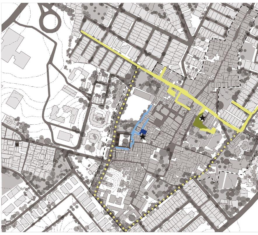
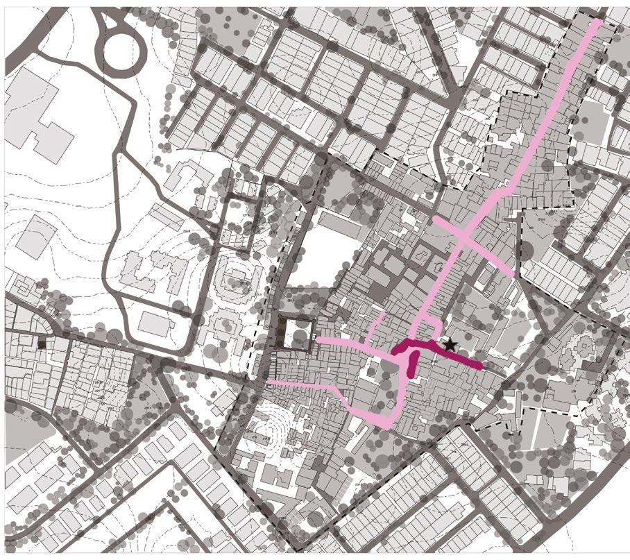


The dynamism of the site is reflected not only by its day to night activity pattern but also how this pattern changes in certain days of the week. People of Masjid Moth village take a pride in calling their village multi-cultural with temples, church, gurudwara and masjid peresent at the same setting. Since different days are important for different cultures, the following map shows the important cultural marker on the specific day and how the activity pattern changes
Tuesday
Saturday
Thursday Sunday
Scale


The village comes under the urban village area or lal dora area under land use and current usage and is surrounded by residential colonies namely South Extension, Neeti Bagh and Uday Park. The two edgeds of the village is commercial out of which Leela Ram Market, one of the popular ones in South Extension is recently designated as commercial in Delhi Masterplan 2021 while Sohan Lal Marketon western side is an unauthorised market. There are other informal markets as well (inside the village) which comes under mixed land use according to the current usage. Other surrounding parts are institutional (AIIMS, Nurses’ Hostel, Jain Mandir, Sarvodaya School, Nehru Bal Samiti and Father Agnel School) and another Urban village called Gautam Nagar which according to MPD 2021 is also designated under residential.


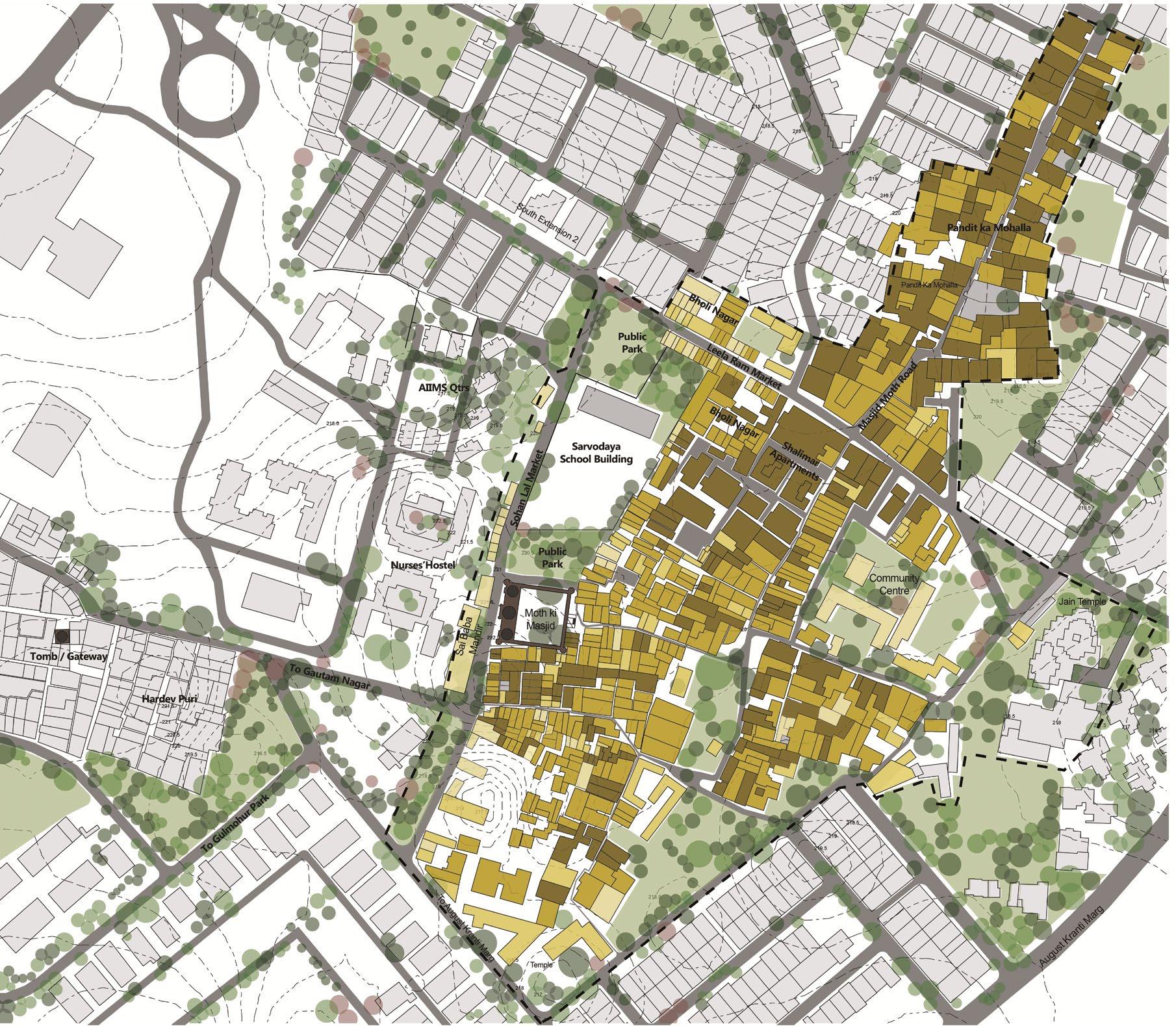

Most of the buildings in the village are G+3 or G+4, surpassing the permissible height limit of G+3 (Height of Monument is 13m) by means of illegal construction works. These buildings fall under lal dora area hence it is difficul to ensure they follow the heritage law of 1958 which doesnt allow new development within 100 meters. According to Zonal Developmen Survey and Mohalla Committee, Leela Ram Marke which falls under commercial zone has a permissible height limit of G+1 but in recent years it has also surpassed the limit and is mostly G+2 or G+3

Comparing the growth in footprint of the village from year 2001 to 2018, which shows there is not much growth in the footprint of the village and the only development which has happened around is AIIMS hospital campus and mero constructions.

Hence the encroachment is not by acquiring the land but in terms of height which surpasses the permissible limi and also the height of the Masjid which poses a threat of overshadowing the existence of the monument.


Inference: Since the buildings are surpassing the limits illegaly, they need to be regularised atleast within 100 meters of protected area, and should also follow non committal language in choosing the material of construction.


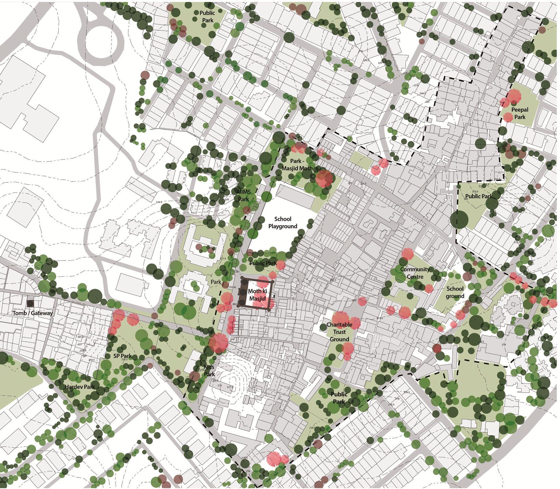
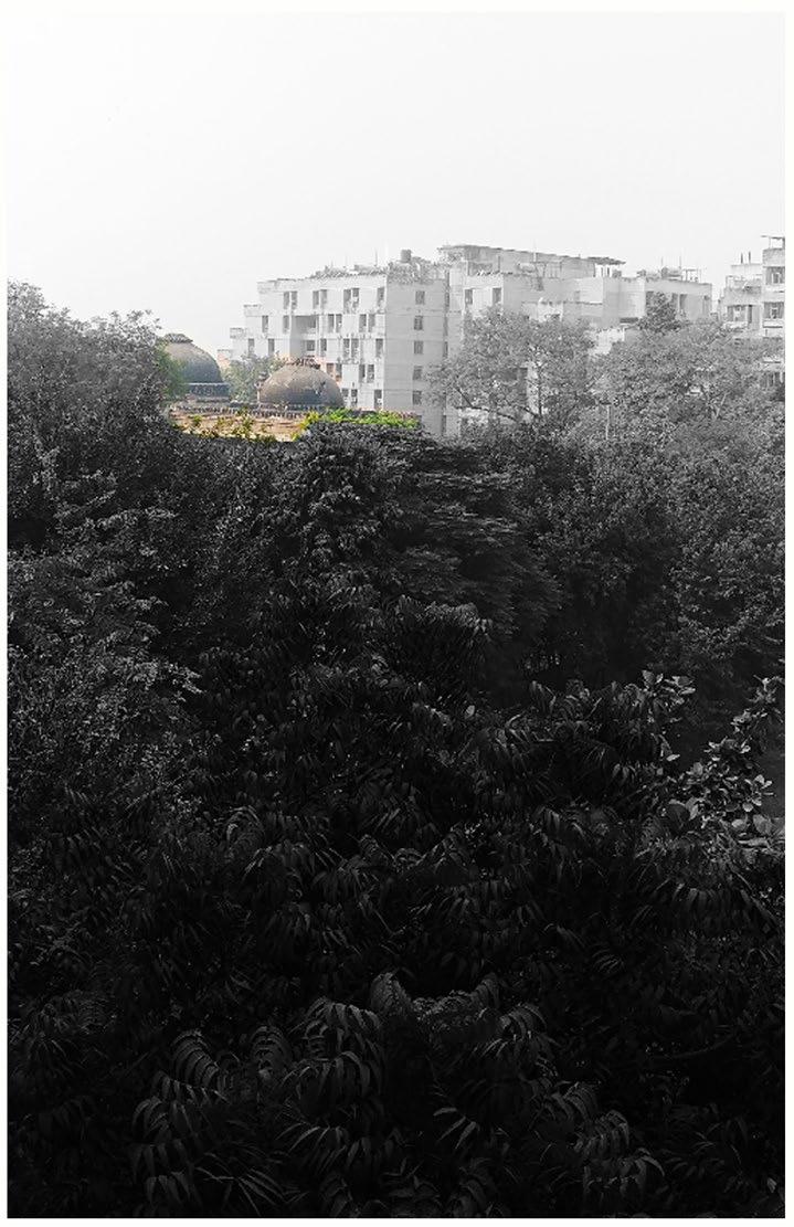
The area is fairly green with planted evergreen predominantly and deciduous trees, giving a dense character to the streets and enough shaded for people to gather around and interact. While Temples are associated with Ficus benjamina (Banyan), Ficus religiosa (Peepal) and Azadirachta indica (Neem) trees, sited around them and worshipping them, A huge banyan tree in school premise has wild character hence abandoned. Certain Mulberry trees have association with children of the village, and Neem trees in th Mosque provides shade to the courtyard, so children could play under them.
Other trees that we can see around the area are Bombax ceiba, Morus alba and Eucalyptus globulus.

Existing Trees Existing Deciduous Type Trees with cultural association
1. Alstonia scholaris
2. Azadirachta indica
3. Albizia lebbeck

4. Bombax ceiba
5. Cassia fistula

6. Delonix regia
7. Eastern cottonwood
8. Eucalyptus globulus
9. Ficus benjamina
10. Ficus elastica
11. Ficus religiosa
12. Ficus virens
13. Mangifera indica
14. Mimusops elengi
15. Morus alba
16. Parkinsonia aculeata
17. Pithecellobuim dulce
18. Polyanthia longifolia
19. Pongamia pinnata
20. Senna Siamea
21. Syzigium cumini
22. Bougainvillea sp.
The list of trees spotted on the site could act as a palette for planting in the proposal. There are certain trees that blocks the view of the Masjid from important places like school, Market etc. These tree were recently planted about 4 years ago, and can be transplanted.


The village uses public parks for recreaation, mela, interaction etc. while open spaces and courtyards are used by vegetable vendors and other shopkeepers to form an informal market in evenings. Chauraha holds a cultural importance in Hindu religion hence used the most amongst other open spaces

Courtyard of Mosque is used by Children to play, while women of the village use the steps of the mosque to sit and interact in the evening.
Scale


The following map marks the primary road, secondary road and footpath network as well as the material of these. The streets within the village were kaccha streets (soil) and with the urbanisation it got covered in several layers of bitumen and concrete, which today is in dilapidated state.


One of major issues that the village face is of drainage, the following map shows the waterlogging points according to intensity and frequency of rains. It also marks the flow of water according to the contours and observations.
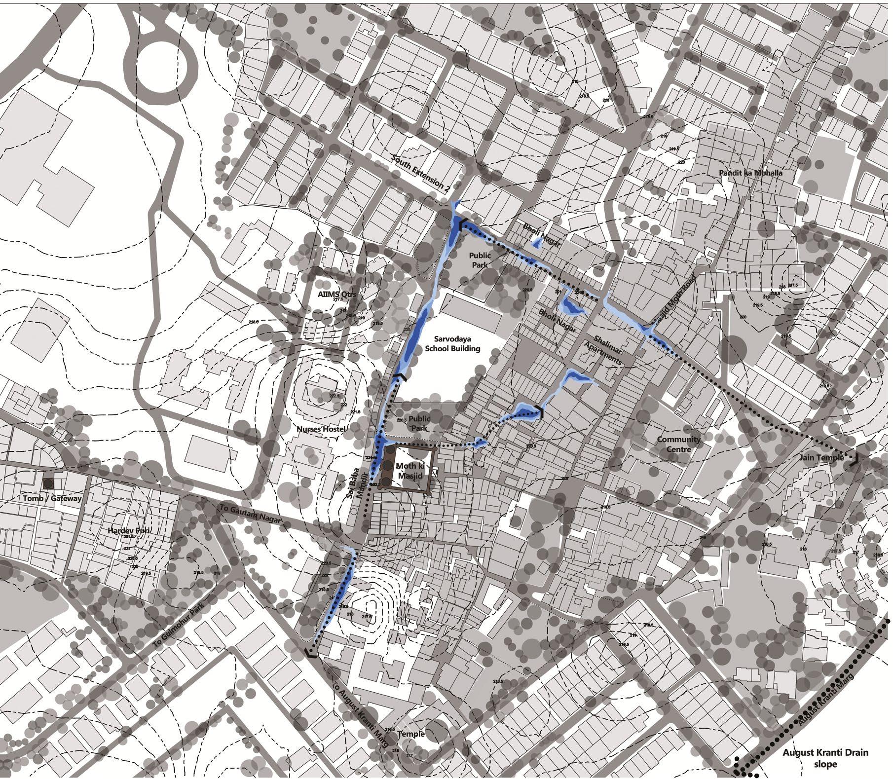
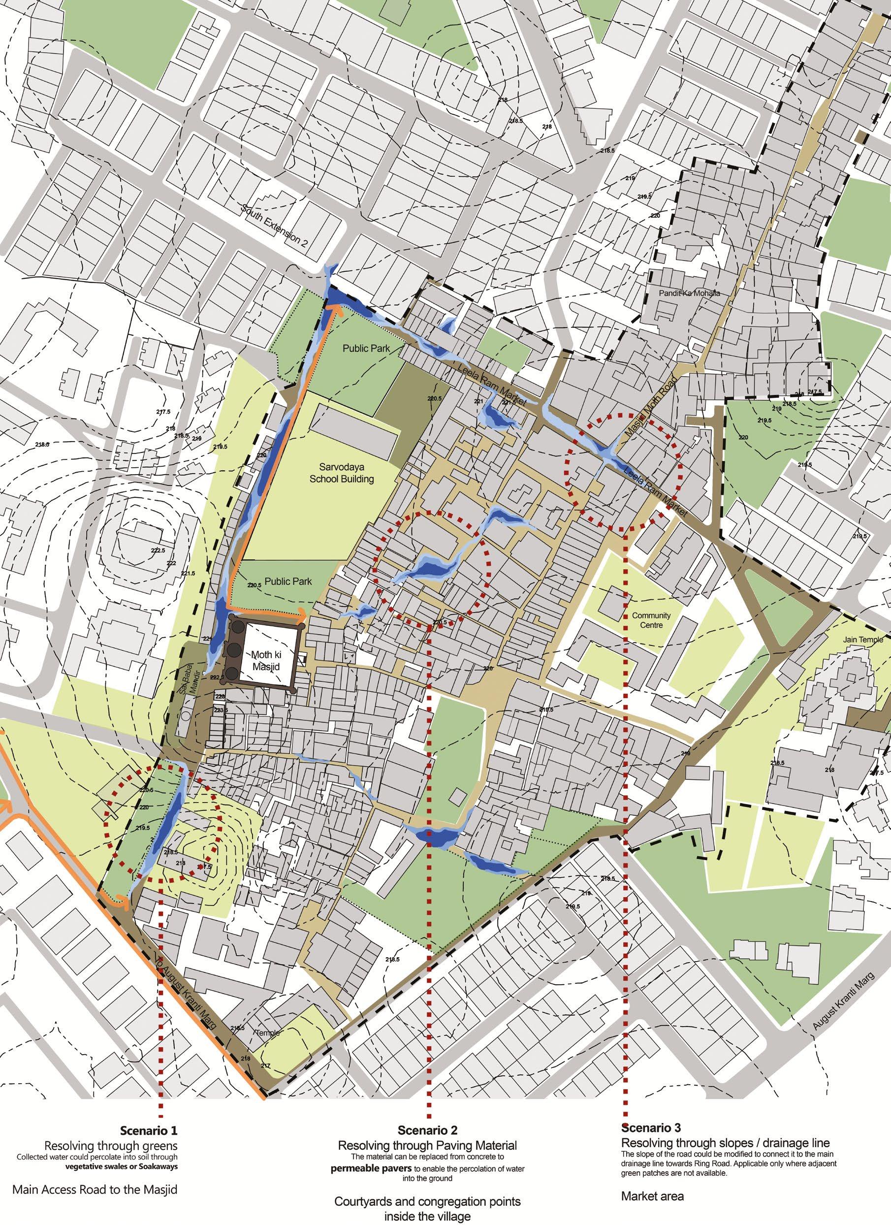
INFERENCE: Several factors has led to waterlogging issues. Uncontrolled urbanisation of village without considering natural slopes, The material of road which doesnt allow percolation, lack of drainage planning of the area.
The terrain of the whole site slopes down towards Masjid Moth and Leela Ram Market Junction and it also slopes down to Bholi Nagar. Hence, these are two lowest points of the site where maximum water collects.
Waterlogged in 1-2 days of rain
Waterlogged in 4-5 days of rain
Waterlogged in one week of rain
Scale

The following map shows the infrasructure provision of the area. It marks various facilities like schools, hospitals, markets, temples etc. It also marks othe convinience facilities like the pole lights installed in the area, solid waste collection points and public toilets
INFERENCE: The map helps to understand the village in terms of facilities provided by government, are they adequate and what additionally the area need to transform it to a hitoric setting.


The area shows inadequacy of lighting around monument, hygiene issues due o the presence of solid waste collection point infront of the monument and school, and lack of parking facilities.

A monument in a neighboourhood gives an opportunity to have interesting peek views from different vantage points of the village. The following two maps show the viewshed of different areas from the monument and vice versa.
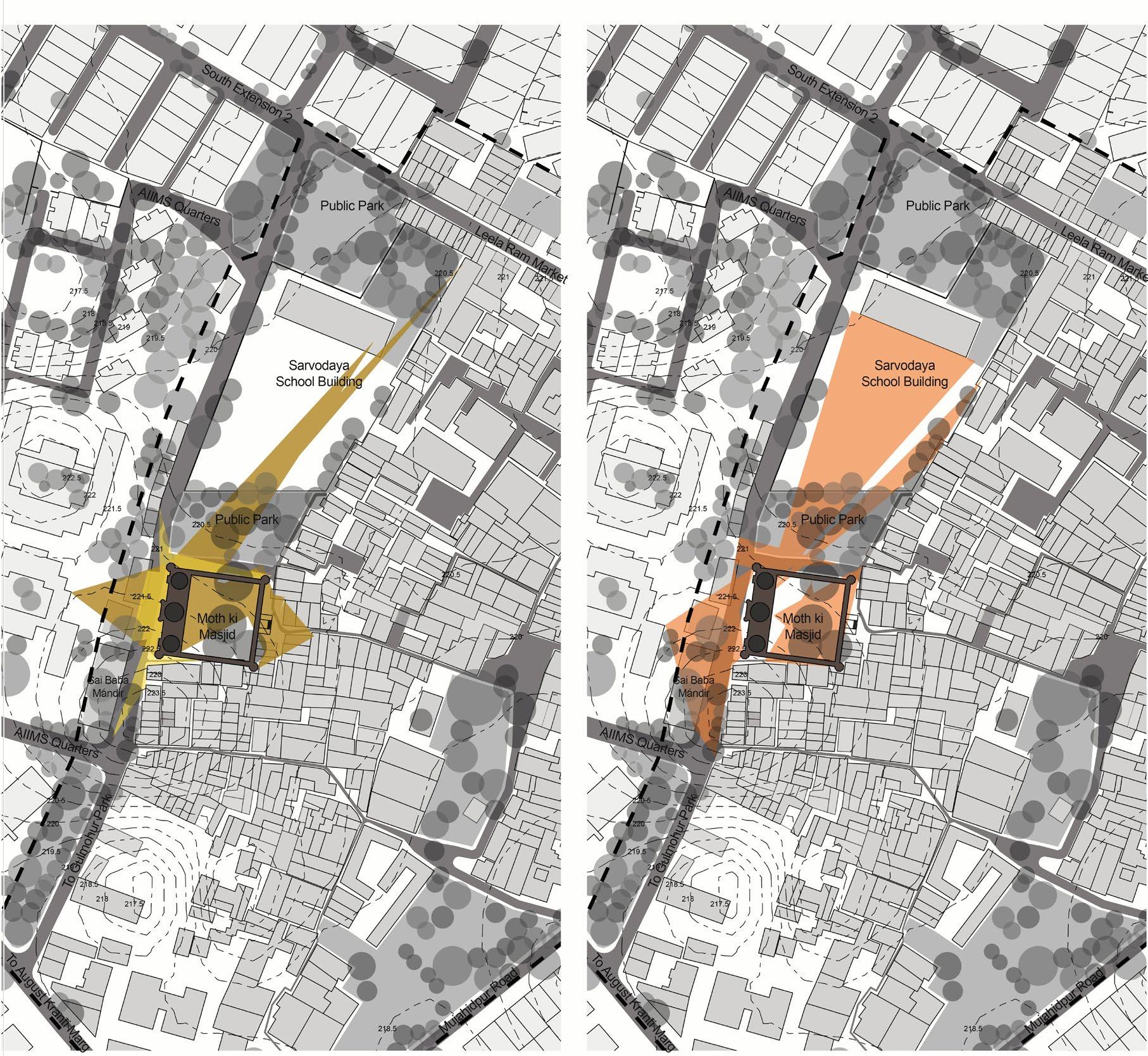
The pictures are collected from these vantage points, and are marked with visual pollution. These visual pollution as weakness can be worked upon to intervene on these important visual points.
(Source : Author)
Scale
N


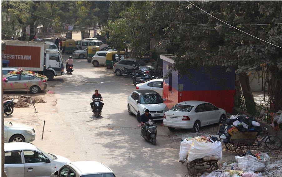
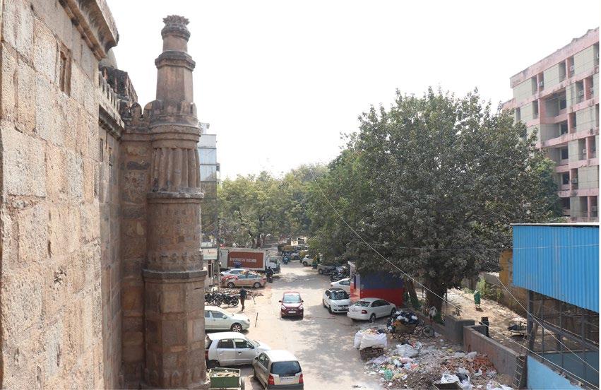
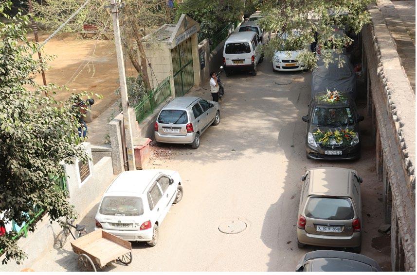
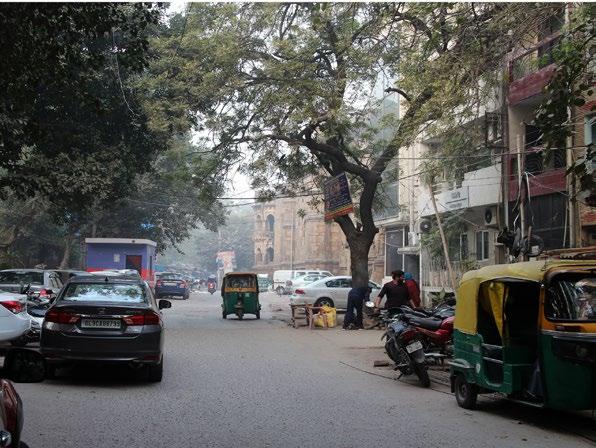





Facilitate local people to prepare a ‘community landscape character Scheme/ Statement
In order to identify what is valuable and important about the landscapes in which people live or work, it is essential to imvolve community. Engaging effectively with local community would help in a productive way to record local opinion about their landscape and capture their issues and desires for its future use and long term management.
For this, it is important to categorise the aspects in which the communtiy could be involvedand do as way forward prepare a document which shows the characetristics of the area invluding topography, landuse and cluster patterns. This will help in coming up with an intervention that complements village design and surrounding and also integrate the historic setting to the dense fabric.
Objectives
• Create a HISTORICAL SNAPSHOT of your landscape which can be preserved for future generations.
• Getting a wide range of people together and to help them articulate heir ideas about their environment.
• Educating the community about the historic environment they possess
• Photo analysis
• Stakeholder Interviews (Personal, phone, text)
• Analysis of surveys by stakeholders
• Workshop (Landscape Character Assessment)
• Listing the concerns and desires
• Pop up demonstration for awareness
• Discussion of first iteration
• Editing
The community was educated about the monuments in their vicinity, its history and its association with people in past. This was done through a group discussion and a series of historic photographs for them to realise the scale and aesthetics of the monument.


(Refer Fig 3.45 - 3.47)
This was done in order to condition them to have their opinions about the monument and how they relate themselves with it.
A workshop was hence conducted in order to record the local opinion about their issues, desires and their association with the monument (From past, present and future) This was done in the five age groups

Group A - below 12 years
Group B - 12 years - 18 years
Group C - 18 years - 30 years
Group D - 30 years - 50 years
Group E - 50 years above
Total Participants - 35
The community was given a plan and an elevation drawing of their area, not to scale but prepared according to the mental mapping of their area so they could relate. (Refer Fig. 3.48 - Fig. 3.51)
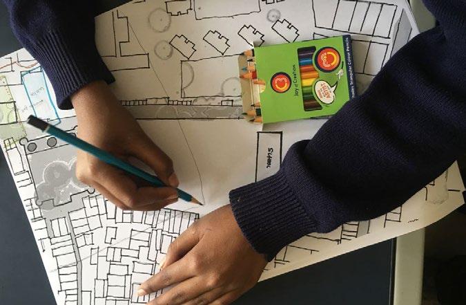
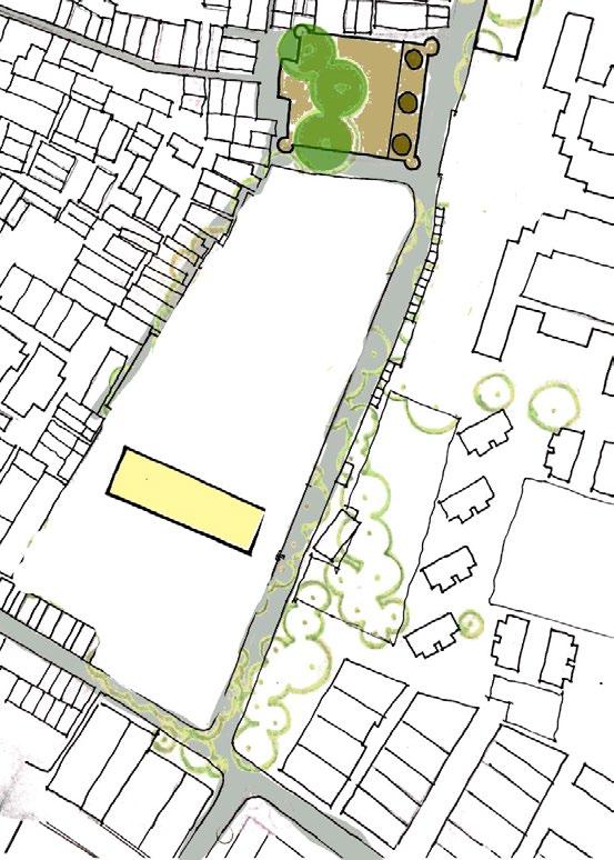


 Fig. 3.48 Plan view of the village for ideas
Fig. 3.51 Elevational view for understanding and attempt ideas about association
Fig. 3.49 Plan view of the village for understanding the context
Fig. 3.50 Workshop (Source : Author)
(Source : Author)
Issue Analysis
Monument Governance Residents Schools/Students Market/Temples
Encroachment Football ground Unused ground spaces School boundary wall cant be used
Unusable/Exploited spaces Proper Park/Jogging area Drainage problem (Front) No designated market (Only sohan lal market)
Drug Activities, Vandalism Regularised, safe market No play area after school Shops – Multiple floor construction (illegal)
Unsafe, haunted stories Water logging Garbage stinks, diseases Traffic Congestion
No Proper lighting, signage Parking Masjid should be used for namaz Veer bazaar - unregulated
No time to play, Timings Lighting within mohalla Encroachment of school wall, increasing unusable spaces Waterlogging
Lack of Awareness Community halls (privatised) Cafes / Cafeteria Random Parking spots
Parking on the monument walls Water issues Reading spaces/Library/ educational area Unhygienic environment (dump land, cows etc.)
Dumpland, Police Chowki infront of the market Illegal construction Clear Footpath Congestion during festivals
Timings of the monument Public areas/ cafes No time to play, Timings Proper Footpath, Pathways Unhygienic environment
0-17 years
17-30 years
30-40 years
40-55 years > 55 years
The issues were analysed to identify the key issue which could help solve the other issues. The diagram enables to understand the relationship of monument and community and issues arising from them being together
The aspirations from various stakeholders which includes residents, children coming to school, ASI department, Market shopkeepers and Resident welfare association.
• Community areas for functions, weddings etc.
• Parks that can be used by all
• Traffic convenience
• Parking spaces
• Proper roads/ Infrastructure
• Cafes / Public spaces around monuments
• Retained courtyards for everyday interaction
• Methods to save water to curb shortage
• Greenery around monument and in village
• Hygienic environment
• Drainage system for village
• Regulated veer bazaar
• Increased footfall of tourists around monument for gains
• Community spaces for village

• Retained religious importance in the place
• Public utilities
Associations
Inferences:
The community involvemen or participation was essential to know in what direction according to the stakeholders, the development should happen.
The monument resides in a neighbourhood in which any change will affect the lifestyle of people residing around and it may also take away the unique character of the site.
The sensitivity towards the community at stake must also be in the priority along with other physical and social values of the monument.
The results of the workshop helped formulate a collage of the associations related to the monument in past, present or future. This collage was then shown to to the participants for them to know the ideas of others and also how they can build their own association with the monuments
Fig. 3.53 Association Collage4.1 Gol Gumbad, Lodhi Colony


Location / Area: Lodhi Colony, New Delhi / 45m x 30m (including regulatory buffer)
Date of Completion: 2010
Landscape Architect: Priyaleen Singh (INTACH)
Listing of the site: Department of Archaeology, NCT Delhi

• The context involved a church (Methodist Church) which used the premise of Gumbad as Parking.
• The Gumbad was encroached by public activities, tea stall, Parking etc.
• The conservation scheme changed the activity pattern of the monument.
BRIEF:
The conservation scheme not only freed the monument from years of encroachment but also helped in creating movement around the structure. In the mean time the DDA records were examined for the extent of land around the monument that was earmarked for the state archaeology department and it was found that about 15 m on three sides (East, South and West) belonged to the department. The land had been used by he church authorities for past many years for parking and some other public activities.
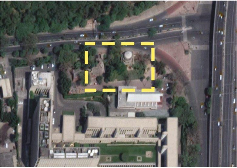
The landscape proposal was prepared and the scheme was also discussed with the church authority who offered to help in rearing the green space. The landscape which was one of the highlights of the project not only enhanced the value of monument but also offered a much wanted public open space for locals. The space is very happily used by the nearby office staff and passers-by during the day’s break. While in the night the illumination provides an experience of rich heritage in the city, and does not take away the mystery the tomb previously offered
• The monument doesn’t expect a lot of tourist footfall but is used as a backdrop to create an experiential journey on the roads of Delhi.
• The Gumbad had a mystery associated with it, which the lights does not take away.
• Creates an area to congregate and brings back the dignity of the monument, by proposing a relevant landscape scheme. It gives a successful example of integrating the immediate context with its heritage to create a holistic design beneficial for both.
• Objective of the landscape is to mainly give an appropriate immediate setting of the monument.
• Provide planter with low shrubbery on the south and the east side of the structure, beyond plinth protection.
• Remove high shrubbery on the east side to prevent accumulation of garbage.
• Open up the view of monument from the east side.
• Integrate the parking lot entry from the North with the design of planter on the east side of monument.

4.2 Conservation of Tomb of Bijri Khan, RK Puram (Commonwealth games)

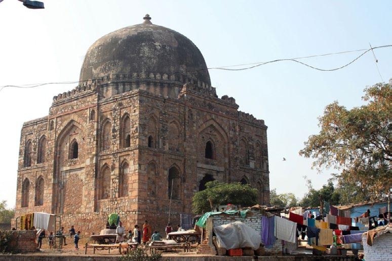
Location / Area: RK Puram, New Delhi / 170 sq. m. (including regulatory buffer)
Date of Completion: 2010
Landscape Architect: Priyaleen Singh (INTACH)
Listing of the site: Department of Archaeology, NCT Delhi
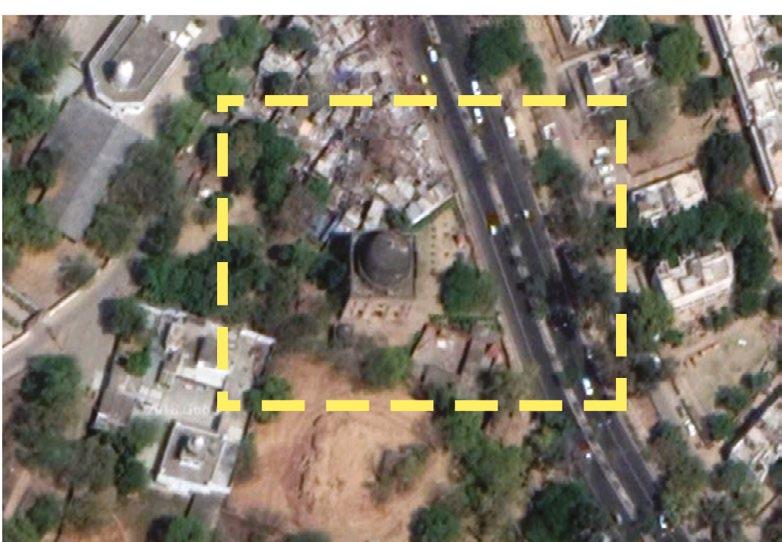
RELEVANCE:
• Absence of appropriate setting to the monument.
• Area around monument not defined.
• Tomb being encroached by the village around and activities introduced did no correspond to the heritage character of the area
BRIEF:
• The conservation scheme
• Defined the boundaries with a fence, a design of which is reflective of he period of the tomb. Fencing is necessary to prevent encroachments.
• Provided a flight of steps directly from the road, to replace the present entry through the slum.

• The east edge of the site was proposed to have a low fencing in order to visually connect from the road.
• The stretch of retaining wall facing the road and defining the high plinth was re-done following the random rubble masonry, keeping with the historic character of the site.
• Grove of Kaner shrubs and the creepers on the south-east par of the site, to restrain the presence of temple wall.
• Paving connected the plinth protection of two structures.
• Removed play equipment to avoid encroachment through activities
• The conservation scheme did not respond to the contemporary use of the area, hence became derelict soon after the conservation and landscape scheme
• It left the community with less of play and usable green area, while the tourist footfall did not increase

• While the idea of making it visible from the road worked, but the setting it used to hold with temples and gurudwara around got segregated and did not work holistically.
• Currently in order to avoid encroachment, the entry is barred for locals and they have to approach the security guard to get its gates opened.
• The conservation and landscape scheme treat the monument as a historical marker in the landscape.
• Bringing dignity to the monument
• Increase visibility
• Provide appropriate setting
• Interpret historic context
• Integrate with contemporary experience
• Low maintenance
Location / Area: Nizamuddin Basti, New Delhi
Date of Completion: 2010
Landscape Architect: Mohammad Shaheer
Listing of the site: ASI, UNESCO World Heritage, AKTC
RELEVANCE:
• Landscape of DDA neighbourhood parks in he vicinity of heritage structures, now maintained by community groups


• participation of community women users, and other users to understand the usage of the park – community participation
• Creating urban spaces by understanding the community, even a conservative ones.
BRIEF:
Although five acres of parks have existed for some time, the spaces were occupied by rag-pickers and drug dealers. Only two percent of the resident population were accessing park spaces. Following sustained community consultation, a landscape scheme for these parks was prepared and implemented. Parks have been developed for specific uses, such as a children’s play area, a screened park for the exclusive use of women, a park for community events and a play field for youth-related activities. The parks, becoming ‘lungs’ providing fresh air to the residents, are now managed by the community with AKTC support.
• The careful treatment of the space to make every person of the community have a recreational space.
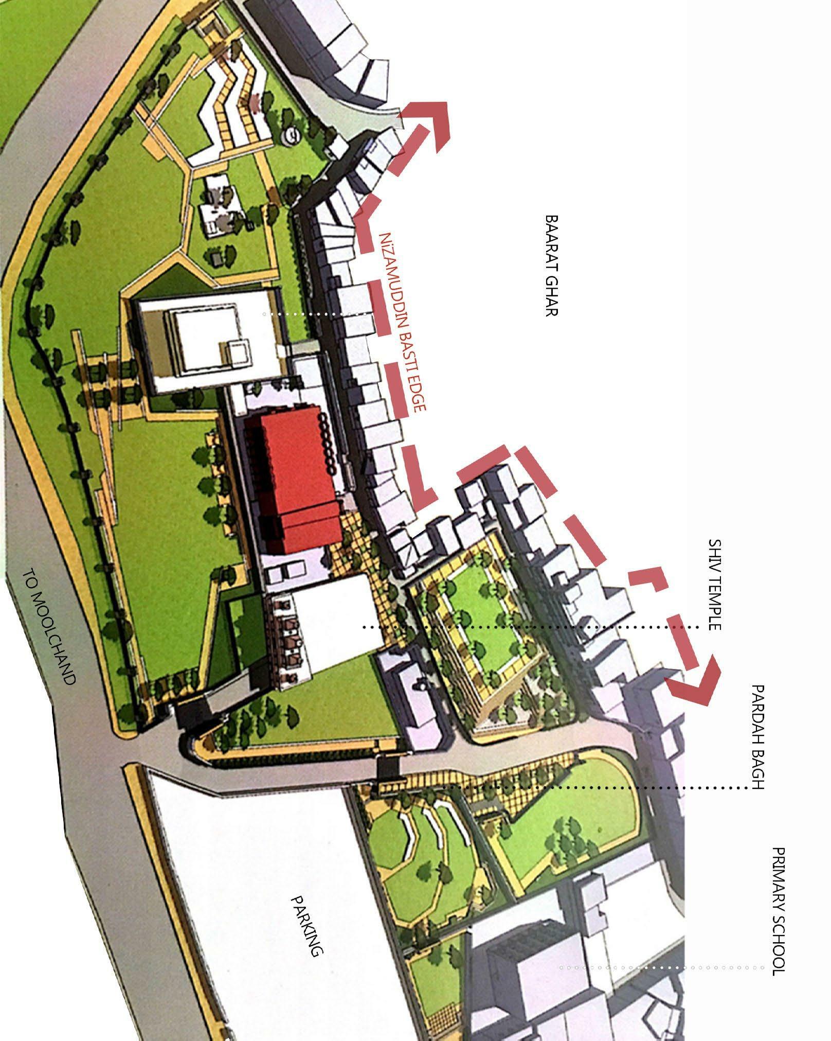
• Park timings have been increased to foster enhanced user base. Presently the park timings are 7 to 12 in the morning and 2:30 to 5:30 in the evening.
• Bringing in the culture that represents the community, in an otherwise obsolete space
• Division of spaces, to enhance usability
• Creating an ownership of community, hence getting maintained by them.
Overlapping the green/open space map and cutlural network map and culural network map to identify potential open spaces that could aid the historical setting and also enhance the unique character of the village.
It also identifies areas where alternate entries to the masjid could be proposed. Multiple entries are proposed to reflect the presence of a heritage structure and hence bringing the focus or identity back. (MAKING PRESENCE FELT)

Since the surrounding buildings are retained, the open and green spaces could be the marker for heritage in this case. The entries could make use of community parks to demonstrate the heritage character and also add a layer of value to the park.
Potential parking spots inside the village needs to be identified in order to avid parking on the monument wall.This does not completely fulfil the parking requirement of the village but corresponds to the amount of parking that happens around the masjid.
A clearing as an option could be provided by relocating a total of 15 houses to create a space for the moque and its heritage corridor.
This corridor can be used by thursday vendors to avoid its extension towards Leela Ram Market. This avoids the chaos in the market on Thursday and creates an activity around the mosque every week.
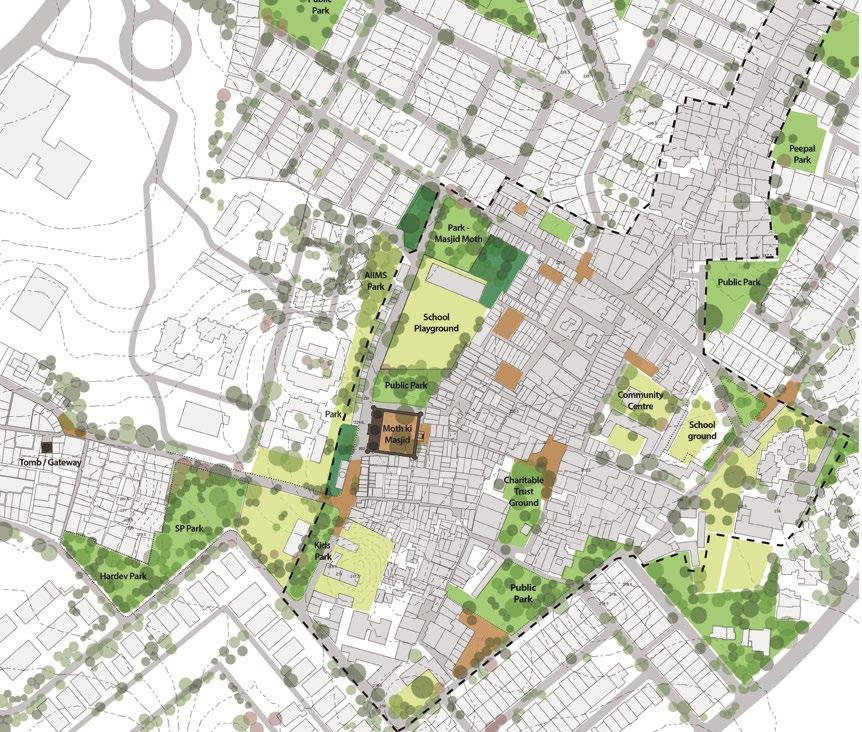
Potential Parking Spaces // Considering the amount of Parking happening on Monument Wall Heritage Clearing // Need for Historic Buffer zone (Regulation)

Community Open Areas overlapping wih Historic zone or traditional bazaar
Potential (Regulatory) Heritage Green Network

Potential for partial relocation of thursday market
Assessment of Open Spaces, Analysing the pressure on greens to identify open spaces that could be used as heritage greens to establish new network and a way to bring back he lost identity and dignity of the monument

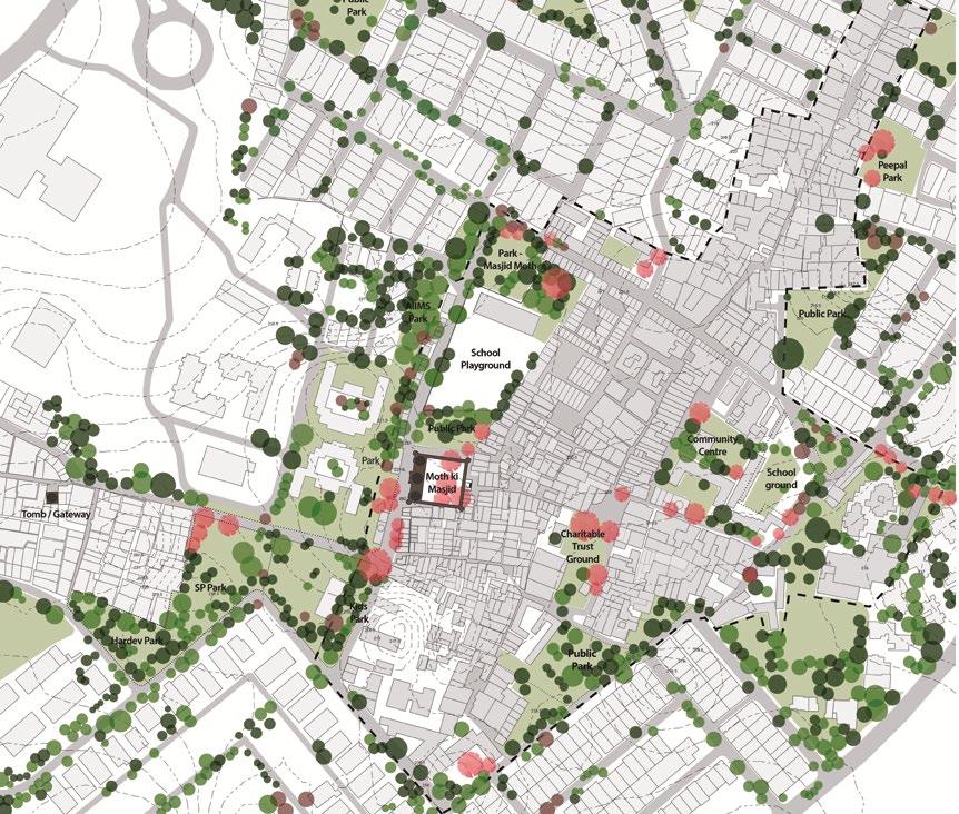
Overlapping the drainage map, green spaces map and Road Network / Material map to resolve the drainage issues of the area.
The scenarios are divided in three broad categories, one is where green patch is availabel on eithr side of the water collection point, second is where there are no green spaces available (generally inside the village) and third where the drainage flow could be reworked.
The map marks such scenarios and possible solutions like proposing soakaways, changing the material to permeable ones and reworking


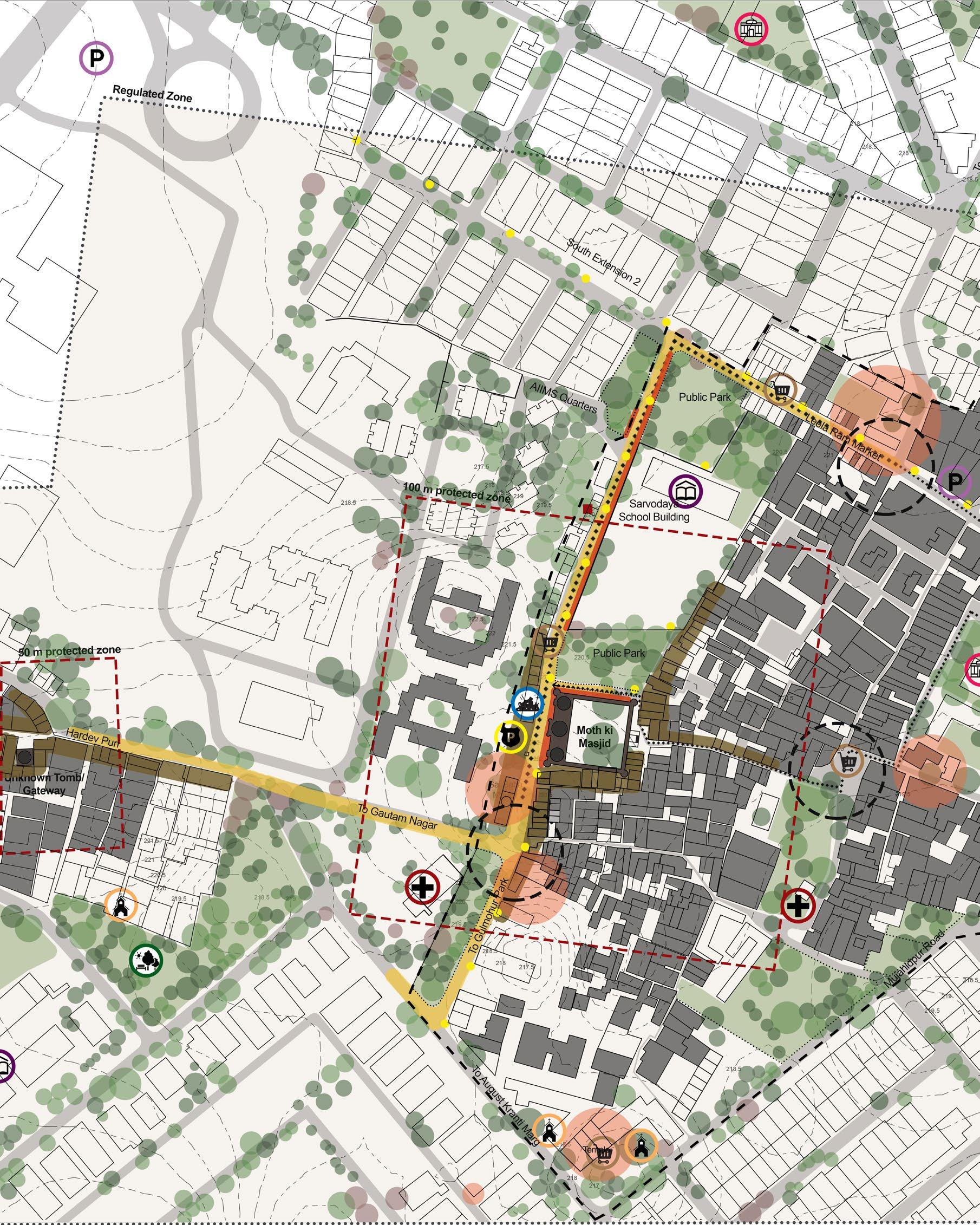
overlapping the cultural network, building heights and infrastructure map to analyse the adequacy of it as a historic setting and what all need to be considered while intervening


Considering the presence of an important marker (Sai Baba Temple) and the way they should function together so that the popularity of the temple must not overshadow the monument.
It also highlights the areas around the monument that are most exploited and needs an intervention
Building heights above the height of monuments are marked, permissible height limit must be regulated.
The map also highlights the potential connection between the two monuments.


Considering the inferences from synthesis maps and case studies, following builds up the conceptual framework for the Masterplan.
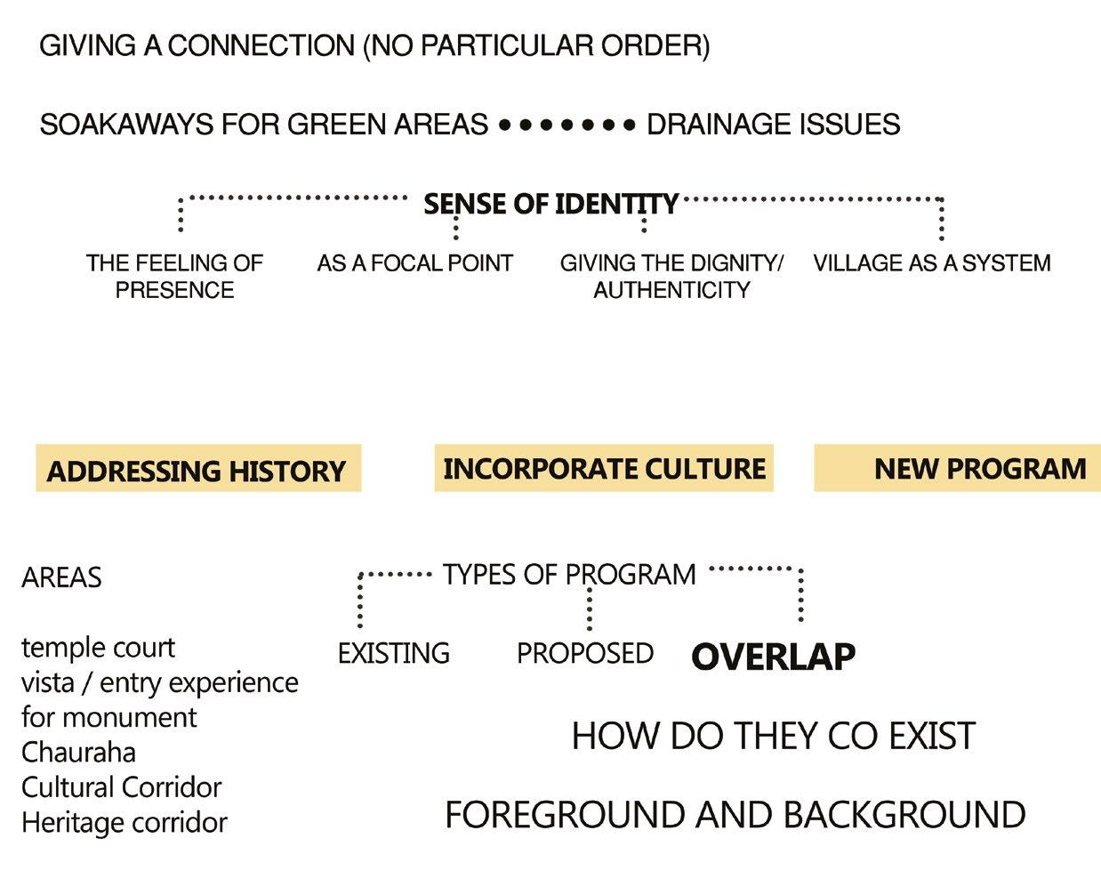
1. HERITAGE AND CULTURAL CORRIDOR The village as described, reflects the coexistence of heritage and culture. Since there is a point (Sai Baba Mandir plaza and Masjid’s West wall) where they overlap, gives an opportunity to create a plaza where this conflict is celebrated. Where the coexistence doesn’t overshadow each other, but the characteristics of one complements the other. The proposed heritage corridor is connection between the Unknown Tomb / Gateway and Moth ki Masjid, whereas the cultural corridor is the connection of four religious maarkers present in the village. Both the corridors reflect the sprit of the place, and is specific to this area.
2. BACKGROUND AND FOREGROUND for the Heritage setting. The bare minimum dignity one can give to heritage is clutter free foreground and reflecive background. Since the entrance to the monument is through streets, retaining the unexplored, mysterious character would retain the depth this monument holds. The west wall of the Masjid has the potential to get 30 m foreground infront by relocating the dumpyard and opening up the unused green patches to create a forecourt for the monument. The wall of the nurses’ hostel could also be rebuilt to make it a transparent railing with dense evergreen trees on the other side. This way the foreground would reflect continuity and be clutter free.
3. MULTIPLE ENTRANCES to re-establish the lost identity. In order to bring back the identity overshadowed, the first step could be to make its’ present. Area where there is a way to Masjid Moth village could be dedicated to reflect the heritage character to make the presence of it evident. Negotiating with the community parks to insert the heritage character could work for the same.
4. SHARED OPEN SPACES certain community parks that have direct link to the monument need to reflect both the presence of heritage and community to coexist cordially. One way to do it is by using the vocabulary of the heritage and but retaining the function of it for the community.
5. CLEARING (A spiration and Reality) The ideal situation for the monument would be to have atleast 10 m clearing on all sides, where 15 households could be relocated and that stretch would reflect the scale of the monument, and the sense of seamlessness.
But also considering the fact that these 15 households contribute a great number in christian community, and relocating them means thwarting it. Hence another situation could be to retain them, and reflect this state of decay which a large part of Delhi’s monuments face.
6. CRITICAL ZONES There are some critically important zones which are directly linked with the monument and need an intervention in order to celebrate this connection. Such zones are school which could have a visual connection with the monument and also direct connection so that the whole premise feel the continuiy. Another one is the Shani Mandir Chauraha, which is also the entrance plaza for the Masjid, hence the coexistence is reflected at this junction as well.
7. EXPERIENCES as expressions are mentioned in the conceptual masterplan to build the historiction throughout the two corridors and the vista of he approaching roads. Although the sense of mystery needs to be retained, some basic necessary moves like conservation of the Unknown Tomb / Gateway is essential and a small plaza as a pause could enhance the experience. The Rajiv Gandhi Hospital wall which falls in between he heritage corridor can reflec the historic presence and also be the signage to educate people visiting it. The lighting also needs to be such that the sense of mystery is reflected and also the lighting is ample for the adjoining buildings to walk freely in the night
8. PLANTING strategies are to complement the setting, while the forcourt needs to have dense planting on the other side of nurses’ hostel wall, the one towards the school need to have less canopy trees to mantain the visual connect. The road approaching to the Masjid from Leela Ram Market is to have low heigth shrubbery to get the glimpse of Masjid on the way.
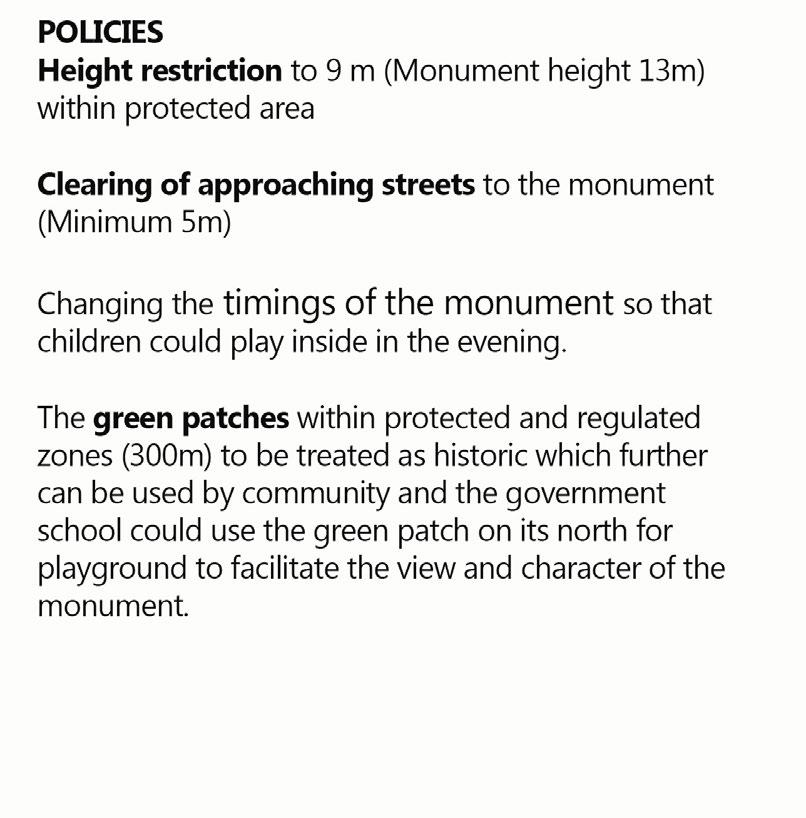
9. POLICIES S ome policies need to be enforced in order to have the better management strategy for the village. Buildings within the 100 m radius must be of height less than that of the masjid. Height restriction to 9 m (Monument height 13m) within protected area Clearing of approaching streets to the monument (Minimum 5m)
Changing the timings of the monument so that children could play inside in the evening. The green patches within protected and regulated zones (300m) to be treated as historic which further can be used by community and the government school could use the green patch on its north for playground to facilitate the view and character of the monument.
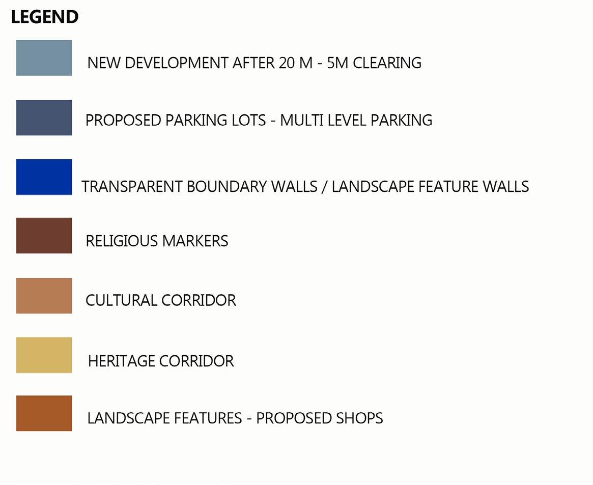
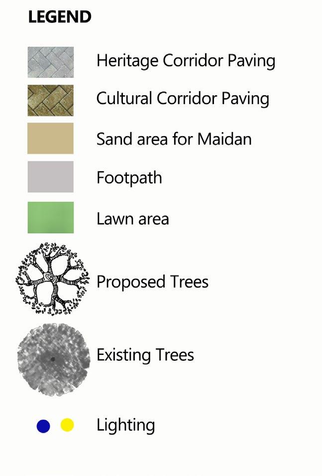
ENTRY PAUSE FOR HERITAGE CORRIDOR

HERITAGE CORRIDOR - CONNECTION BETWEEN THE MONUMENTS
SHIFTED SCHOOL GROUND
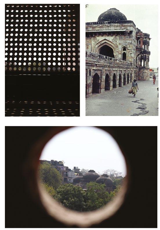
JAALI WALL FOR VISUAL CONNECTION
CULTURAL PAUSE POINTS
CULTURAL CORRIDOR
PARKING SPOTS
JAALI WALL - FUSION OF SCHOOL JAALI AND NICHES
HERITAGE CORRIDOR // ALTERNATE ENTRY
Heritage in Neighbourhood Monica Chaudhary | PA200416

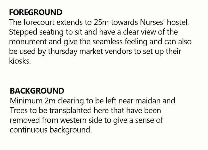



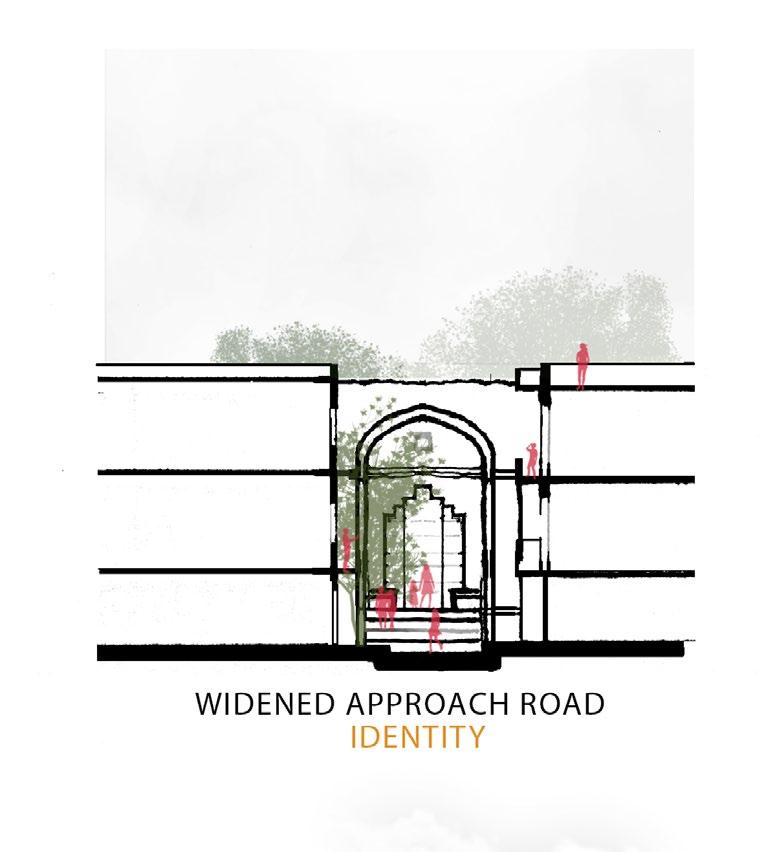


The school is visually connected, kids playing in the maidan can feel the seamless relation with the Masjid
The steps and transparent wall reflects continuity and can be used by thursday vendors to set up heir kiosks.
Other days, Clear view to the monument
The benches and paving pattern is aligned with the niches in order to make it active.
Passive recreatinal space for the community as well as tourists
The most active space in the vicinity of the monument, as it gets the best view of it.

The banyan tree has its cultural connection with the temple, but infront of the mosque it provides a court to celebrate the co-existence of two religious markers.


The cultural and heritage corridor reflects the unique character of the village.

The aspirational 10m clearing gives a sense of continuity to the mosque, and one can realise the scale of it while walking through its perimeter

The connection of school, Maidan and Masjid ought to be seamless. They must act like one
The scenario here is more real, it saves a community and reflects the nature of decay any old thing (monument) goes through. It shows the suffering of the monument, but also the shelter it has given to many.
A s a way forward we can infer a few parameters that could help in identifying the spirit of the place and possible consideration for intervening in a similar typology of heritage.
SIGNIFICANCE OF THE MONUMENT. Study the value and significance of the monument and the cultural significance of he village.
EVERY MONUMENT IS UNIQUE. the setting, character and association of the monument with the communiy must be analysed before intervention. A monument has a huge impact on the lifestyle of the neighbourhood around it. And intervenion should be specific to the context and culture.
DIGNITY OF THE MONUMENT If a new program needs to be incorporated on the site, the dignity of the monument must be retained, it should respect the history of the place. For example char bagh of Taj Mahal cant be converted to a playground.
LOST IDENTITY OF THE MONUMENT assessment of various factors due to which identity has been lost and how it can be crought back. Identify the points of opportunity within context, without thwarting it. Bringing back the identity would make the monument less susceptible to vandalisation and educate more people about their surrounding
SPIRIT OF THE PLACE while the Physical or tangible layers give spatial character to the site, intangible or social layers define the quality and usage of the area which is called the spirit of the place.
NATURAL LAYERS.Ecology and natural layers must be studied for the deeper understanding and working of the site. And it is utmost important to analyse how much natural layers can be recovered, in case the site is hidering some natural system.
SAME POLICY MIGHT NOT WORK FOR EVERY MONUMENT assess, analyse and present the qualities which thwarts the dignity of the monument. In this case the encroachment was not only within 100 meters but also vertical. For each monument prohibited zone could be identified independently.
CASE STUDIES are important to understand the learnings and mistakes for a similar setting. Things that works for a similar context could be adopted.
Adila Mitra. (2015). Monumental encroachment: ASI and AAP government look the other way as Delhi’s architectural heritage sites are turned into a squatters’ paradise | Daily Mail Online. Retrieved May 7, 2018, from http://www.dailymail.co.uk/indiahome/indianews/ article-3064666/Monumental-encroachment-ASI-AAP-government-look-way-Delhi-s-architectural-heritage-sites-turned-squatters-paradise.html
Aga Khan Trust for Culture. (n.d.). Archnet. Retrieved May 5, 2018, from https://archnet. org/print/preview/sites=1576&views=i
Delhi Master Plan (MPD-2021). (2009). What is Lal Dora. Retrieved May 4, 2018, from http://webcache.googleusercontent.com/search?q=cache:http://delhi-masterplan.com/ the-lal-dora-opportunity/what-is-lal-dora/&num=1&strip=1&vwsrc=0
Mehra, A. K. (2005). URBAN VILLAGES OF DELHI, 279–310.
O’Donnell, P. (2008). Urban Cultural Landscapes and the Spirit of Place. 16th ICOMOS General Assembly and International Symposium: ‘Finding the Spirit of Place – between the Tangible and The, (November 2006), 1–8. Retrieved from http://openarchive.icomos. org/67/
Sohail Hashmi. (2007, August). The Hafta Bazaars of Delhi – KAFILA – 10 years of a common journey. Kafila. Retrieved from https://kafila.online/2007/08/06/the-hafta-bazaars-of-delhi/
Urban Resource Group. (2008). An Ecological Overview of Delhi. 48 Degree Celsius. Retrieved from http://www.48c.org/ecologynote.pdf
(A)
: Heritage Grade-I comprises buildings and precincts of national or historic importance,embodying excellence in architectural style, design, technology and material usage and/or aesthetics; they may be associated with a great historic event, personality, movement or institution. They have been and are the prime landmarks of the region. All natural sites shall fall within Grade-I.
Heritage Grade-II (A&B) comprises of buildings and precincts of regional or local importance possessing special architectural or aesthetic merit, or cultural or historical significance though of a lower scale than Heritage Grade-I. They are local landmarks, which contribute to the image and identity of the region. They may be the work of master craftsmen or may be models of proportion and ornamentation or designed to suit a particular climate.
Heritage Grade-III comprises building and precincts of importance for townscape; that evoke architectural, aesthetic, or sociological interest through not as much as in Heritage Grade-II. These contribute to dete mine the character of the locality and can be representative of lifestyle of a particular community or region and may also be distinguished by setting , or special character of the façade and uniformity of height, width and scale.
: Heritage Grade-I richly deserves careful preservation.
Heritage Grade-II deserves intelligent conservation
Heritage Grade-II deserves intelligent conservation (though on a lesser scale than Grade-II and special protection to unique features and attributes).
