
71 minute read
OUTDOORS REPORT


#1
Montana’s rank among states in per capita participation in wildlife watching (according to the U.S. Fish & Wildlife Service, 2011 survey).
Peck was picked as no. 1 by In-Fisherman.
FISHING SURVEY FINDINGS
National fishing magazine names Fort Peck Reservoir the nation’s top walleye water
The big-brown fly
While many anglers are trying to entice 13-inch rainbows and cutthroats with tiny dry flies, there’s likely a 20-plus-inch brown trout lurking nearby that wants to eat something big. That’s according to Montana fishing expert John Holt of Livingston. Holt writes in his recently published Stalking Trophy Brown Trout that large browns hang out in deeper runs and along undercut banks. Anglers need to drift a big, meaty fly down to the bottom where the big fish hide. His lunker rig of choice? A Woolly Bugger—particularly a Cree-hackled pattern of his own design—tied to a 4X tippet with a single split shot pinched near the knot. “I’ve taken more browns over 20 inches on this pattern than all the others I use combined,” Holt writes. n In-Fisherman recently announced what Heath Headley has known all along. The widely read national angling magazine ranked Fort Peck as the nation’s number one walleye water in its 2013 Walleye Guide. “For ample eaters plus cisco- fattened footballs over 10 pounds, fish the upper reaches and Big Dry Arm early, then troll deeper mid- and lower-lake areas in June and July,” the magazine reports.
“That pretty much sums up where to fish for walleye here,” says Headley, FWP Fort Peck Reservoir fisheries biologist.
Headley adds that Fort Peck now has record walleye and northern pike populations, thanks to ideal lake level conditions from 2008 to 2011. “And this year the Corps of Engineers is drawing the lake down,” he adds. “That’ll create less forage productivity, which means walleye and other game fish will be hungry.”
Headley says the only cloud on the sunny fishing forecast is that low water levels will likely result in poorer walleye and pike production this year. “Low water means good fishing for existing adult fish, but unless we get some high lake levels in the next few years, we won’t have the strong populations in the future that we’re seeing now.”
Low water could also make it tough to launch boats from some ramps. “Scope it out before you start backing your trailer down,” Headley warns.
The biologist says the In-Fisherman report will no doubt attract more anglers than usual to Fort Peck this year: “Fortunately, it’s a huge reservoir, so there will be plenty of room—and plenty of fish—for everyone who wants to come out here.” n
THINGS TO DO
Visit Montana’s lowest and highest points
Most people assume the lowest spot in Montana is on the flat prairie somewhere in the state’s eastern half. It’s actually at the state’s westernmost boundary, where the Kootenai River crosses the Idaho border along U.S. Highway 2, about 20 miles northwest of Libby. There the elevation drops to just 1,820 feet as the Kootenai flows to the Columbia River, which feeds into the Pacific Ocean.
The state’s highest point is in the AbsarokaBeartooth Wilderness: 12,799-foot Granite Peak.
Only experienced climbers Kootenai River at the Idaho border should attempt to reach the 1,820 ft. summit. But it is possible for most reasonably fit folks to at Granite Peak 12,799 ft. least see Granite Peak during a long day hike. Drive to the West Rosebud Trailhead at Mystic Lake, south of Columbus. Take the trail along the creek, around the south shore of Mystic Lake, and then veer south toward Upper Princess Lake. As you gain altitude, you should be able to see Montana’s highest point to the south. n
WOLf MANAGEMENT SURVEY FINDINGS
Wolf harvest up 36%, population down 4%
Montana saw a significant increase in the number of wolves harvested during the 2012 season, which ended February 28, 2013. Hunters and trappers took 225 wolves (128 and 97 respectively), an increase of 36 percent from the 166 wolves harvested during the 2011 season. The 2012 season was the first that allowed trapping.
An additional 108 wolves were killed through agency control efforts to prevent further depredation to livestock and by private citizens who caught wolves chasing or attacking livestock. Depredation losses totalled 108 cattle, sheep, and other domesticated animals, down substantially from a peak of 309 in 2009.
Montana’s wolf population remains healthy, say FWP biologists. The state wide population at the end of 2012 was a minimum of 625, down 4 percent from the 2011 tally of 653. The minimum count is the number of wolves actually verified by FWP wolf specialists.
The population decline is the first since 2004. “We’re making progress,” says FWP director Jeff Hagener. “Confirmed livestock loss has been on a downward trend since 2009, and we now have more management tools for lowering wolf numbers where necessary.”
In parts of western Montana where hunting, trapping, and livestock-depredation removals have been effective, wolf population growth appears to have been curbed this year. “But we still have more work to do in places where wolves are putting undue pressure on deer and elk populations and livestock producers,” says Hagener.
The FWP director says roughly 400 to 500 wolves would constitute a healthy, stable population. “But that’s just a rough target, not a definitive goal,” he adds.
FWP sought and received from the 2013 Montana legislature additional tools to increase future wolf harvests if needed. A wolf management bill—
sponsored by Representatives Kelly Flynn and Ted Washburn—won swift and overwhelming bipartisan legislative support and was signed into law by Governor Steve Bullock. The new law gives hunters the opportunity to harvest three wolves by “ We’re making progress. Confirmed livestock loss allowing them to purchase up to three wolf licenses, and should increase nonresident participation by lowering the price of a nonresident wolf license from $350 to $50. has been on a downward When signing the legislation, Bullock trend since 2009.” asked FWP to beef up educational efforts to help hunters avoid shooting radio-collared research wolves near Yellowstone and Glacier National Parks. Wolf recovery in the Northern Rockies remains one of the fastest endangered species comebacks on record. FWP didn’t obtain full management authority over wolves in Montana until the species was delisted in 2011. The delisting has allowed Montana to manage wolves similar to the way it manages bears, mountain lions, and other big game animals, using management plans, administrative rules, and laws. Hagener says he is reconvening Montana’s wolf advisory council, originally formed in 2006 to help develop the state’s wolf management plan. “We want to check in with the broad spectrum of viewpoints regarding wolves, as represented by the council, and continue discussing Montana’s ongoing wolf management with them,” he says. n
In the first regulated season that allowed trapping, trappers harvested 97 wolves, while hunters killed 128.
Three great birding areas
A great source for locating the state’s top bird-watching sites is the Montana Natural History Center’s Montana Birding and Nature Trail guide. The on-line source lists dozens of trails in the Bitterroot Valley, around Missoula, and across northeastern Montana. Click on the map to find information on each trail, the habitat it contains, and likely bird species found there. An example of a birding site listed on the guide is Camp Creek Campground in the Little Rocky Mountains, near Zortman and just south of the Fort Belknap Indian Reservation. The campground offers a remarkable variety of mountain and forest species, despite being surrounded by river breaks and prairie. Species there include the red-naped sapsucker, dusky (blue) grouse, pinyon jay, MacGillivray’s warbler, and Lewis’s woodpecker.
Visit the birding trail website at montanabirdingtrail.org. n
Spot pinyon jays in the Little Rocky Mountains near the Fort Belknap Indian Reservation.
GOOD FOR GRASS, GOOD FOR

R GRAYLING

An innovative new conservation agreement could help save an imperiled fish while easing pressures on Big Hole ranchers.
BY BEN ROMANS. PHOTOS BY THOMAS LEE

HARNESSING GOODWILL Don Reese and FWP grayling recovery biologist Emma Cayer inspect a new fence on the ranch that Reese manages in the Big Hole Valley. Built with federal and state funds, the barrier will keep cattle from trampling the banks of a Big Hole River tributary. The combination of public funding and landowner cooperation is making the Big Hole grayling project a nationwide model for fish and wildlife conservation. On a hot summer afternoon, Emma Cayer and I are driving through the upper reaches of the Big Hole Valley to check the flow gauge in a rancher’s irrigation canal. Cayer—the arctic grayling recovery biologist for Montana Fish, Wildlife & Parks—negotiates the bumpy dirt road while leaving a plume of dust behind. It’s late August 2012, at the height of a near-statewide drought, and distant wildfires fill the sky with smoke.

Between the squashed bugs and dusty wiper streaks, I see a small green sign flanking what I assume is a drainage ditch. The watercourse is so narrow the truck’s tires straddle its width as we cross. Through the passenger window I read the sign: “Big Hole River.” Whatever portion of the Big Hole this is, it looks nothing like the brawny blue-ribbon trout river farther downstream.
“That is a testament to our work,” Cayer says, reacting to my befuddled look. “Years ago at this time of year, you might not have found any water in that part of the river. Now it’s flowing, and there’s a good chance you can find grayling there. It’s proof that ranching and grayling can coexist.”
For years such a harmonious relationship seemed unlikely. But in 2005, ranchers and other landowners, biologists, and hydrologists set out to accomplish something long thought impossible. They aimed to improve stream flow and habitat for the last population of fluvial (stream-dwelling) grayling in the lower 48 states—without harming the ranchers’ bottom line.

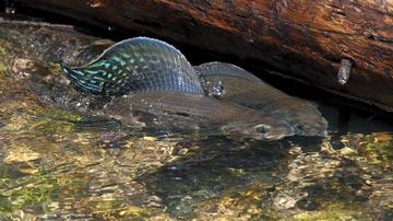
Edge of survival Though the Big Hole is best known for its trout fishing, no description of the river is complete without acknowledging its arctic grayling. This close cousin to trout was historically found throughout the upper Missouri River basin as far downstream as Great Falls. Today the last native population of river-dwelling grayling is restricted to the upper Big Hole basin.
The species has long been prized for its rarity, iridescent beauty, and, perhaps most important, the scenic high-elevation areas where it lives. “Big Hole River grayling are in a unique ecological setting,” says Jim Magee, a biologist with the U.S. Fish & Wildlife Service’s (USFWS) Partner’s Program. “They’re in a temperate zone that doesn’t flow into Alaska or the Hudson Bay, but actually into the Gulf of Mexico. No other river-dwelling grayling in North America lives in that type of environment.” Montana’s grayling, it turns out, occur on the very edge of where the species can survive.
For years the fish’s existence seemed solid. Grayling require cold, clear water, and the chilly upper Big Hole had plenty of winter snowpack aboveground and icy springs below. Though local cattle ranchers historically drew vast amounts of water from the river to flood fields for growing grass—later cut and cured to make hay—there seemed to be enough for both livestock and fish. Then came the droughts of 1979, ’80, and ’81.
After those dry years, biologists began noticing a decline in the upper river’s grayling population. Because stream water levels dropped too low, temperatures rose dangerously high and grayling become stranded in pools, unable to reach cooler water. When the next severe drought caused portions of the Big Hole to actually run dry in 1988, it appeared there might not be enough water in the river for growing grass and sustaining grayling.
To address the problem, government agencies, trout anglers, ranchers, and others formed programs and groups—notably the citizen-led Big Hole Watershed Committee. They raised public awareness and identified areas where grayling habitat had been degraded in the upper Big Hole, which extends from the headwaters above Jackson downstream to Dickie Bridge near Wise River. They also reached consensus that saving the salmonid would be impossible without landowner involvement.
Unfortunately, the groups could not resolve the main issue: water allocation. Under Montana law, landowners own the water rights and have little incentive to share.
Then, in the early 1990s, the federal government considered whether to protect grayling under the Endangered Species Act. It eventually deemed that protection was “warranted but precluded”—meaning that, despite legitimate concerns over grayling survival, other species elsewhere in the United States faced even bigger threats requiring federal attention. Mounting legal pressure from environmental groups since has forced the government to take yet another look at
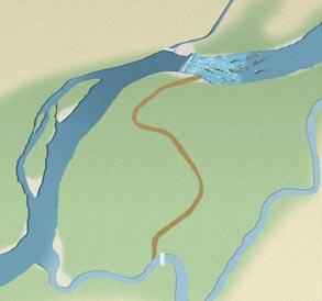
Upper Big Hole River
Fishtrap
Wisdom Wise River
Melrose
Kalispell Havre
Great Falls
Missoula
Helena
Butte Lewistown
Bozeman
Billings
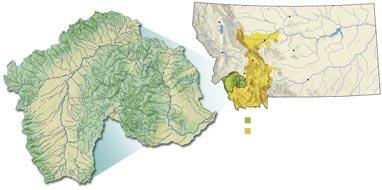
Jackson Glen CCAA project area Fluvial arctic grayling historic range
Fluvial (stream-dwelling) arctic grayling historically were found throughout the upper Missouri River basin as far downstream as Great Falls. Today the fish is limited to the upper reaches of the Big Hole Valley, now the focus of a new conservation partnership program. LAST BASTION Deep winter snowpack and icy underground springs have long made the Big Hole Valley—shown here downstream from Wisdom—an arctic grayling stronghold. For decades enough water existed for cattle and the sail-finned fish, but droughts over the past 30 years have made it difficult for ranchers to leave enough water in the river while still irrigating grass for cattle.
the grayling’s plight. Its decision is due by the end of 2014, meaning that federal listing could be right around the corner.
Ranchers don’t want that. Neither do government conservation agencies. Many biologists now maintain that in some cases Endangered Species Act protection can be counterproductive, because people who own property where imperiled fish and wildlife live often work more cooperatively to conserve habitat without federal intervention. “After droughts in 2000 and 2001, we racked our brains trying to figure out how to get grayling back on track by working with landowners,” says Magee, who at the time was FWP’s grayling recovery biologist. “But people we approached were saying, understandably, ‘Why should I give up my water
when my neighbor is just going to use it?’”
As a temporary solution, the federal Natural Resources Conservation Service (NRCS) in 2004 paid ranchers not to irrigate. “That’s how our agency really started getting involved in the Big Hole,” says NRCS district conservationist Kyle Tackett. “The agency was saying, ‘Look, we’re in, and here’s what we’re willing to do.’”
Landowners took notice. For the first time, they weren’t just being asked to give up some water; they were being paid to do it.
Though rewarding private water conservation made sense, handing out cash wasn’t the long-term solution. It was too expensive. And it didn’t address problems like the need to improve grayling habitat and institute conservation practices throughout the
watershed that could maintain stream flows. Fortunately, a better idea was on its way. Rest assured “ During the early 2000s, the USFWS concluded that species such as the arctic grayling that were “candidates” for federal protection might benefit if the government could offer “assurances” to cooperating landowners. Under the agency’s Candidate Conservation Agreements with Assurances (CCAA) Program, participating Big Hole Valley landowners would agree to specific habitat and stream flow restoration projects on their property. In return, ranchers and other private partners would benefit two ways. One, the conservation projects could reverse grayling popula-

People were saying, understandably, ‘Why should I give up my water when my neighbor is just going to use it?’”
tion decline and reduce the likelihood of federal listing. Two, the agreement would ensure that, should the grayling be designated as federally threatened or endangered, cooperating landowners would not have to give up extra water or do anything else not covered in the existing conservation plan they helped create for their property.
Do things to help grayling now, the federal agreement said, and you won’t be penalized later if the species is listed.
The CCAA was written to offer ranchers enough incentive to make helping grayling worth their while. What’s more, individual contracts were designed so landowners could opt out at any time. Still, convincing Montanans who traditionally shun bureaucracy to sign on would be a tough sale.
A core workgroup comprising representatives from FWP, the two federal agencies, and the Montana Department of Natural Resources and Conservation (DNRC) floated the CCAA concept past Calvin Erb, a local attorney and owner of one of the valley’s largest properties. He thought it made sense. “We [landowners] wanted to negotiate something that didn’t change every year,” Erb says. “That’s why that CCAA appealed to me. It meant finding some finality about our obligations as landowners for grayling recovery.”
Erb’s endorsement carried weight. Soon other landowners and ranchers began asking to take part. With the first formal enrollment in 2006, more than 30 Big Hole landowners representing nearly 150,000 acres signed on, making it the largest CCAA in the country.
The positive response had as much to do with building trust as it did with federal assurances, says Magee. “Many of us have been working with these landowners for years and developed strong relationships,” he says. “One thing we learned was that patience and partnerships go a long way. They know we aren’t going to tell them how to run cattle or water their fields.”
The “nuts and bolts” That’s not to say all land-use practices could continue as they had for generations. To conserve enough water for both grayling and grass, irrigation refinements were necessary. The first step was for members of the workgroup to meet with each enrolled landowner and create a site-specific conservation plan, what Cayer calls the “nuts and bolts of the CCAA.” During conversations over coffee, both sides found middle ground that met federal requirements without harming the rancher’s grass production. “We had to listen closely to each other
to make it all work,” Cayer says.
The individual plans identify specific conservation actions that do four things: improve stream flows in the Big Hole and its tributaries; enhance the condition of stream channels and banks; remove barriers to fish movement; and reduce grayling “entrainment” (fish straying into irrigation ditches and ending up stranded there or in fields). The most important feature of the plans requires landowners to reduce, temporarily, the amount of water they use when stream flows in various parts of the upper Big Hole and its tributaries drop below targets—for example, 40 cubic feet per second (cfs) in summer. “Basically, everyone gives up a little bit of water until we get back above the target,” says Cayer.
Temporarily forgoing even a small portion of the water allowed under their water rights generally doesn’t sit well with Montana ranchers. That’s especially true in drought-prone areas like the upper Big Hole. Averaging only 22 frost-free days per year, the valley’s short growing season does not facilitate raising cash crops. Here, cattle are king, and feeding the king requires grass. “We live and die by hay,” says Guy Peterson, a Big Hole rancher. “This is a fairly arid part
of the state, and our window to grow isn’t very long. So we traditionally keep the ground saturated and hope to cut as much as we can later in the summer.”
Fortunately, enough water exists for cattle and fish—but only with more efficient use. By employing better irrigation equipment and information—funded by CCAA agency partners—ranchers can divert less water from the Big Hole system and still meet their grass production goals. One way the agency partners helped landowners conserve water was to install 71 new headgates. Ranchers use these adjustable damlike structures to control the amount of water entering irrigation canals from streams.
To report instantaneous flows and water
The author of Montana’s Best Fly Fishing, Ben Romans is a writer now living in Boise, Idaho.

availability for irrigation, DNRC hydrologist Mike Roberts installed four real-time stream flow gauges in strategic locations within the project area, adding to existing gauges. Ranchers can now monitor flows on their home computers or even smart phones so they know exactly when to scale back or increase water use. “For us to sit down and start talking to landowners about water savings and flow conservation, we need quantitative data,” Roberts says. “That makes a big
difference compared to just saying, ‘Well, we don’t think you should irrigate as much. You need to reduce your flows.’” One landowner, initially skeptical about CCAA enrollment, later told Roberts he used less water to produce more hay after following recommendations from CCAA advisers.
Successful site plans Though essential, maintaining adequate stream flows for grayling is just half the equation. “This is also about creating places for these fish to survive,” says Roberts. “You can have a big concrete channel with all the water in the world, but it’s not going to help grayling reproduce” (see “Improving Where Grayling Live,” page 14).
So far the CCAA Big Hole project has cost $3.6 million. Funding has come from FWP’s Future Fisheries Improvement Program as well as the NRCS, USFWS, Bureau of Land Management, Big Hole Watershed Committee, and Big Hole River Foundation. The Nature Conservancy, Trout Unlimited, and state wildlife grants have also contributed.
For their part, landowners and agency staff are required to review the site-specific
plans twice each year to see if conser“vation objectives are being met. Cayer, a longtime rider who often accompanies ranchers on horseback, says she always looks forward to the reviews. “There’s nothing more satisfying than visiting the Big Hole River with a landowner after a project is completed and seeing that it has really taken hold.”
The site plans seem to be working. Despite the drought, the 2012 count for age one or older grayling in the upper river was the highest it’s been since the CCAA program started. And while much of Montana endured extreme or severe drought last year, the Big Hole—traditionally one of the first rivers where FWP closes fishing during
COFFEE TALK Federal, state, and landowner partners in the Big Hole CCAA regularly sit down to discuss better ways to keep grayling alive and ranches afloat. Facing page, left to right: Emma Cayer (FWP), Mike Roberts (DNRC, also above center), Kyle Tackett (NRCS), Jim Magee (USFWS, also above left), and Big Hole rancher Guy Peterson (also above right) at Peterson’s dining room table. “Here we were talking about Guy’s grazing concerns, any irrigation problems he might have, his water usage, things like that,” says Cayer. “This is something we do at the end of every growing season so we can check compliance with the conservation agreement and landowners can let us know of their concerns and successes.”
dry spells—continued to flow with no recreation restrictions throughout the summer.
Perhaps even more significant, landowners such as Peterson are acknowledging the respect and attention they receive through the CCAA process. “Most ranchers in this valley aren’t used to the level of consideration that Emma, Jim, and the rest of the crew give us,” says Peterson. “It gets our attention and lets us see that what the CCAA proposes is good for the river and good for ranching.
“It’s worked well enough for me to keep up these efforts should the CCAA ever go away, or heaven forbid, the fish becomes listed,” Peterson adds. “I have grayling in my backyard. Who else in this country can say that?”
Improving Where Grayling Live
Saving grayling requires more than just water; it also means restoring places in the Big Hole River and its tributaries where grayling live. “If we don’t fix the habitat problems, we’re not doing much good,” says Emma Cayer, FWP arctic grayling recovery biologist.
To improve grayling habitat, state and federal agencies have restored 27 miles of stream channels. This usually requires reconfiguring previously straightened stretches to their historic serpentine shape, which naturally produces deep hiding cover and cleaner spawning gravel.
One example is Rock Creek, historically a vital tributary for grayling reproduction. The stream was rerouted in the late 1980s from the Big Hole directly into an irrigation ditch. In the past few years, workers have restored the historic channel, reconnected it to the mainstem river, and installed incubators to hatch out grayling eggs.
Along streams throughout the watershed, volunteers have planted more than 70,000 willow seedlings. When grown, the shrubs will prevent banks from eroding in high water, add cooling shade, trap silt during high flows, and attract terrestrial insects that drop into the streams. In addition, 34 fish ladders have been installed to allow grayling to move both upstream and downstream past diversion dams—wood plank barriers built years ago to direct water into irrigation systems. “Grayling will travel 60 to 70 miles each year to spawn, overwinter, and reach cooler stretches in summer,” Cayer says. “Barriers definitely can hurt the population.”
Partners also installed fencing along 110 miles of stream banks to keep cattle off critical river and tributary stretches at certain times of year. By trampling banks, cattle make streams shallower (and thus prone to warmer temperatures) and increase silt that smothers fish eggs downstream. Though cows can keep weeds under control, they also graze bank-stabilizing willows and other shrubs. So that livestock can drink, state and federal agencies have installed, away from streams, 55 watering systems, each consisting of a newly drilled well, an electric pump, a power source, and stock tanks. “We’re finding ways to improve grayling habitat without making life harder for landowners,”says Cayer. n
GOOD HORSE SENSE Reese and Cayer discuss reasonable options for restoring willows to a trampled stretch of a tiny tributary. “This is my favorite part of the job,” says Cayer. “It’s a time when we can just get out and talk about what needs to be done both for gray ling and for the ranch operation.”

“I’M HERE!” By crowing at dawn during the May mating season, a rooster pheasant announces his presence to potential mates and rivals, similar to the bugling of a bull elk.

Counting Crows
FWP biologists listen closely each May to get a fix on pheasant populations.
By Parker Heinlein
SCOTT THOMPSON PARKS his truck at the edge of a gravel road a few miles outside Malta and turns off the engine.
It’s still dark, but the Larb Hills to the east are visible against the dawning sky. It seems every bird in Montana is singing on this brisk morning in early May.
Thompson gets out, walks a few yards away from the truck, and stops. After glancing at his watch, and with head slightly bowed, he begins listening to the avian chorus.
For exactly two minutes he doesn’t move. He simply listens. And while he hears geese and ducks, red-winged blackbirds and meadowlarks, it’s the hoarse crowing of rooster pheasants he’s focusing on, tallying each crow. “I counted 49,” he says. “That’s about the same as last year.”
Thompson climbs back into his truck and heads another mile down the road before stopping to repeat the procedure. The Montana Fish, Wildlife & Parks biologist is conducting a crowing count, an annual ritual he and his colleagues conduct each May across central and eastern Montana.
A Butte native, Thompson spent seven years as an FWP biologist in Culbertson before transferring to Malta in 2010. Biologists have been surveying the route he’s working today each spring since 1983.
The department conducts population surveys of almost all game animals. Biologists aren’t looking for exact tallies—that would be impossible—but rather population trends, up or down, from year to year. They survey mountain goat, bighorn sheep, antelope, and goose populations from airplanes. They tally sage-grouse by counting the number of birds that show up at mating leks. And to get a handle on pheasant numbers, they count the number of rooster crows they hear from the same spot at the same time each spring—a technique developed in 1949 by a biologist for the South Dakota Department of Game, Fish and Parks.
While roosters might be heard crowing, or cackling, any time of year, they are noisiest during the breeding season in early May.
Information gathered from the crowing counts isn’t used to set bag limits or adjust the length of the hunting season—for pheasants, those don’t need to change except when populations severely decline. Instead, it “gives us an idea of winter survival and, when we later factor in summer chick production and survival, what hunters can expect in the fall,” says Brent Lonner, FWP biologist at Freezout Lake Wildlife Management Area near Choteau.
The route Thompson surveys provides a good example of how pheasant numbers rise and fall. The highest count on the route came in 2000, when the average was 55. The lowest numbers were in 1985 and 1986, with an average of 9. “It was probably drought related,” Thompson says. The ten-year average for this route is 35 crows per stop.
Cory Loecker, an FWP biologist in Great Falls, heard average numbers of rooster crows during his 2012 survey from Ulm to Cascade. He was encouraged by what he heard on his route east of Geraldine. “In 2009, ’10, and ’11 there was no hatch there whatsoever,” he says. “But this year [2012] is setting up to be very good.”
Fortunately, pheasant populations rebound almost as quickly as they plummet. “It just takes one good hatch,” Loecker says.
After learning how pheasants fared during winter, biologists closely watch the skies. In a few weeks, when the roosters quiet down and hens take to their nests to lay eggs, weather becomes critical. “If chicks get wet, they’re pretty much done for,” Loecker says. Over the past several years, cold, wet Junes in parts of central Montana have hampered pheasant production, even in areas with decent crowing counts.
Though they don’t keep roosters from crowing, wind and rain make it difficult for biologists to hear the birds. So do passing trains, highway traffic, and, apparently, age. Thomp-
son tells of a veteran FWP biologist whose crowing count numbers began dropping for no apparent reason. It turns out the pheasants weren’t declining, just his hearing.
Thompson makes one last stop on the route south of Malta. The sun is up now and, as the day has brightened, the count has gone down. Crowing peaks shortly after sunrise, and the biologist hears only a couple of faint crows during this final two-minute stop. Like barnyard roosters, pheasants have little to say in the full light of day. But come tomorrow morning at the crack of dawn, they’ll be back in full voice.
It’s early May in Montana, and pheasants have a lot to crow about.
Parker Heinlein is an outdoors columnist for the Bozeman Daily Chronicle.
ALL EARS South of Malta, FWP biologist Scott Thompson listens for roosters at sunup.
Yellow Light on the Yellowstone
FWP proceeds with caution as it works to maintain the lower Yellowstone River’s diverse native fishery in the face of diversion dams, water withdrawals, and growing numbers of anglers.
By Parker Heinlein
I’ve always found solitude on the Yellowstone River. Even in rare instances when the parking lot at a ramp is full, it’s usually easy to distance myself from other boaters once I’m on the water and riding the river’s strong current.
I learned to row a drift boat on the Yellowstone near Livingston. I’ve fished the river from its humble beginnings above Yellowstone Lake to as far downstream as Columbus. But never have I felt so isolated on the river as I did during a 2005 trip from Intake Diversion Dam to the confluence with the Missouri River at Fort Buford.
Photographer Erik Petersen and I launched my 15-foot aluminum fishing boat into the Yellowstone just below the dam shortly after dawn. As rain fell from thick clouds overhead, I lowered the 40hp outboard, fired it up, and pointed the boat downstream. We hadn’t gone 50 yards when the prop hit a rock. I shut off the motor, raised the outboard, and hung on as the boat bounced off the bottom through a shallow riffle.
It was going to be a long day.
Plenty of guidebooks cover the upper Yellowstone River, from Big Timber upstream to Yellowstone National Park. Local fly-fishing shops post river conditions daily. Shuttles are available, access is plentiful, and riverside homes abound.
Not so downstream. In his book Floating and Recreation on Montana Rivers, author Curt Thompson devotes only two paragraphs to the entire lower Yellowstone (generally considered the portion between Billings and the confluence with the Missouri). And on this final 70-mile stretch of river we were completely on our own. None of the few people we saw could tell us how long it
JOHN LAMBING SLOW-MOVING SLEEPER Named for the limestone cliffs lining its banks, the lower Yellowstone is a warmwater river that in any other state would be a star fishing attraction. But in trout-obsessed Montana, the lazy river receives little attention except from the relatively few anglers who have discovered its abundant sauger, catfish, walleye, and smallmouth bass.

would take to reach the Missouri.
We eventually trimmed the outboard enough for it to stay clear of the bottom. But we took a couple of wrong turns down channels that became too shallow to navigate and had to hop out and push the boat back upstream to deeper water. Not wanting to spend the night on the river, we decided there was no time to fish. Shortly before dusk we reached the confluence at the Fort Buford Historic Site in North Dakota. We’d seen hardly a soul all day, just a couple of agate hunters walking the banks.
Other than our vehicle, the parking lot at the Fort Buford boat ramp was empty.
Rediscovering the Yellowstone Since then the river has seen some dramatic changes, many caused by oil. In July 2011, an ExxonMobil pipeline running under the river near Laurel ruptured, spilling more than 60,000 gallons of crude into the Yellowstone. The oil fouled 70 miles of riverbank and took months to clean. Long-term consequences to the river’s aquatic life are unknown.
Oil is also partly responsible for a rise in recreation on the Yellowstone. Over the past six years, jet-boat traffic has markedly increased, no doubt driven by high wages in the Bakken oil field to the northeast. “From Billings to the confluence, jet-boating keeps getting bigger,” says Matthew Lothspeich at Riverside Marine in Miles City. “The oil patch is definitely having an effect on sales.”
Jet boats are propelled by engines that eject a powerful stream of water, allowing the craft to move through shallow, rocky riffles like those on parts of the lower Yellowstone. “People didn’t know about the river, but now they see jet boats out there and want to give it a try,” says Lothspeich, whose best seller runs about $20,000.
High oil field wages aren’t the only thing driving renewed interest in the Yellowstone. Anglers are discovering that the lower river holds more than paddlefish and catfish. Mike Backes, FWP regional fisheries manager at Miles City, says sauger fishing is excellent throughout most of the lower Yellowstone. So is angling for walleye, the sauger’s larger, non-native cousin.
Fishing for the river’s rapidly growing and expanding population of smallmouth bass, another non-native, has become a huge attraction. Backes says bass entered the Yellowstone via the Tongue and Bighorn Rivers after they were stocked years ago in upstream reservoirs. Smallies are now found as far up the Yellowstone as Big Timber and are plentiful downstream to the mouth of the Powder River. (Below there, the river is generally too turbid for the sight-feeding predators to find prey fish.)
While the increasingly popular smallmouth bass fishery thrives on its own, FWP works primarily on managing the river’s 33
Parker Heinlein is an outdoors columnist for the Bozeman Daily Chronicle.
BIG BARRIER The Waco-Custer Diversion Dam, built in the early 1900s, diverts water from the Yellowstone to irrigate approximately 4,300 acres of cropland. Like five other diversion dams on the river, it also blocks and impedes fish from moving upstream to seasonal habitats.


GROWING POPULARITY Long ignored by anglers intent on visiting Montana’s storied trout waters to the west, the lower Yellowstone in recent years has seen a rise in recreational use. Clockwise from upper left: Jet boats allow anglers to navigate the river’s shallow, rocky riffles; the fishing for native sauger, a superb food fish, can be phenomenal on the Yellowstone; some people use the river as a swimming hole; channel catfish up to 20 pounds are not uncommon.

native species, especially sauger, channel catfish, paddlefish, and the federally endangered pallid sturgeon. The biggest challenge to keeping those diverse populations healthy, says Ken Frazer, FWP regional fisheries manager in Billings, is diversion dams. Although it’s commonly referred to as the longest undammed river in the Lower 48, six diversion dams exist on the Yellowstone. These 3- to 12-foot-high concrete or rock structures span the river and divert water into canals that irrigate thousands of acres of cropland in the river valley. The dams also block fish migration—most significantly that of the pallid sturgeon. The cream-colored, shark-shaped fish, which can weigh 80 pounds, was once plentiful in the Yellowstone, considered one of its best habitats. Today the species has been reduced to an adult population estimated at just 120 wild fish, living in the lower Yellowstone and the Missouri River below Fort Peck Dam. The Yellowstone hasn’t been truly undammed since water was first diverted at Intake in 1906, a century after Captain William Clark floated down the river on his return trip from the Oregon
The U.S. Army Corps of Engineers has recently proposed building a new concrete diversion dam at Intake that would be taller than the existing rock dam, already the largest on the Yellowstone River. That, along with other recent decisions on Intake by the Corps and other federal agencies, has FWP officials concerned. “We don’t think these new proposals are in the best interests of federally endangered pallid sturgeon or the many other game and nongame species that occupy the lower Yellowstone,” says Jeff Hagener, FWP director.
The Corps is proposing the new structure as a way to build up a higher water level— or “hydraulic head”—behind the dam to feed a new headgate. The headgate controls water diverted from the Yellowstone into a network of canals used to irrigate 55,000 acres of cropland along the river in Montana and North Dakota. Built in 2012, the head gate includes screens that reduce fish “entrainment”—the loss of sauger, young pallid sturgeon, and other species diverted into the irrigation canal. The new structure was built 200 yards upstream of the old one and requires a higher water level behind Intake Dam to provide enough irrigation flow.
Building the screens was part of the Corps’s obligation under the federal Endangered Species Act to recover pallid sturgeon. The U.S. Fish & Wildlife Service (USFWS) determined the Corps was responsible for pallid recovery because the Fort Peck (Montana) and Garrison (North Dakota) Dams it owns and operates on the Missouri River have contributed to the almost complete disappearance of naturally produced pallid sturgeon, currently reduced to just 120 adult wild fish (which also use the Yellowstone below Intake). Most of these remaining pallids are more than 60 years old. Though they spawn, they haven’t successfully added new young sturgeon into the population in decades because the larval fish can’t survive in the altered river conditions. By impounding the Missouri, the dams also rob the pallid sturgeon of vital habitat and fluctuating water cycles the species has evolved with over millions of years.
In the mid-2000s the Corps announced that the most cost-effective way to recover pallid sturgeon would be to create natural upstream fish passage at Intake Diversion Dam on the Yellowstone, the other river that historically held large populations. In spring the bottom-hugging sturgeon are unable to move past the 12-foot-tall rock structure, owned and operated by the Bureau of Reclamation (BOR), to reach upstream spawning habitats. “A dam that’s 12 feet high is as big a barrier to a pallid sturgeon as a dam that’s 1,200 feet high,” says Hagener. “For these endangered fish, Intake Dam might as well be Hoover Dam.” In 2010, the Corps and BOR decided the best option for helping pallids bypass the dam would be to replace it with a concrete weir that spanned the channel, behind which would be built a shallow-sloped “rock ramp” made of boulders. The weir would impound enough water to feed the irrigation system while the ramp’s gentle incline would allow pallids and other
STURGEON STOPPER At 12 feet tall, Intake is the largest of the six diversion dams on the lower Yellowstone River. The structure diverts water into a canal system that irrigates 55,000 acres of cropland. It also blocks the upstream migration of federally endangered pallid sturgeon. Prevented from reaching spawning and larval habitat, the bottom-hugging fish have been unable to successfully reproduce MONTANA OUTDOORS for decades. LUKE DURAN/
Intake Dam
Existing and proposed structures
New headgate and screens built in 2012
Intake Diversion Dam
Recently proposed bypass channel
Recently proposed channel plug Irrigation canal
Site of old headgate
Initially proposed rock ramp
In 2012 federal agencies proposed helping pallid sturgeon move upstream of Intake by building a rock ramp below the dam. Recently they abandoned the ramp option, which FWP favors, and proposed building a bypass channel that would carry only 15% of the river flow (rather than 100% with the ramp option), plugging an existing side channel, and raising the dam height by 2 feet.
coast.
Big-river fish evolved to make long migrations. Sauger tagged at Miles City have been caught 319 river miles downstream at Lake Sakakawea in North Dakota and upstream 160 river miles just below Huntley Diversion Dam. Shovelnose sturgeon tagged just below Fort Peck Dam have been caught 360 river miles away at Miles City after swimming down the Missouri then up the Yellowstone. “Fish need different types of habitat throughout the year, for spawning, for newly hatched fry to escape predators, and for spending the winter,” says Frazer. “You block that movement and fish suffer the consequences.” Movement blockers Progress to help fish negotiate the dams comes in fits and starts. A passageway built to allow fish to swim around Huntley Dam
species to swim over the weir during spring runoff. In addition, a new headgate would be built to include fish screens that reduced entrainment of any young pallids resulting from the increased sturgeon reproduction made possible by the ramp.
The rock ramp would be “the least cost[ly] option,” the two federal agencies wrote in their final Environmental Assessment (EA), issued in 2010, and “would [also] be easier for pallid sturgeon to navigate than the other alternatives.” (Alternatives were (1) to maintain Intake Dam as it was, or (2) construct a new 2.4-mile-long main river channel sloped in a way that would provide ample water for irrigation while improving upstream fish passage.)
As the new headgate was being built in 2012, the Corps announced it had vastly underestimated its cost as well as the expense and engineering feasibility of the rock ramp. Instead of the ramp, they proposed constructing a fish “bypass”—a new chan-
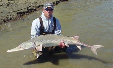
1 OF 120 FWP fisheries biologist Dave Fuller releases a wild adult pallid sturgeon, one of the rarest fish in North America.
MONTANA FWP
nel built around Intake Dam—and building a new concrete dam on the Yellowstone that would be 2 feet taller than the existing one. In addition, a small existing side channel that currently allows some fish passage in high water would be blocked off.
FWP has long stated that if the existing dam were to stay in place, the rock ramp was its preferred alternative. “Instead of pallid sturgeon having 100 percent of the river
flow as proposed with the rock ramp, they would only receive, with the bypass, about 15 percent,” Hagener says. “We are also faced with the very real possibility of an even taller dam at Intake. Along with the loss of fish passage in the existing side channel, we are unsure if the net results would do much to help sturgeon.” In January 2013, the USFWS announced that if the Corps built the fish passage at Intake, then the agency could be absolved of any future responsibility for pallid recovery—even if the structure didn’t result in significant wild sturgeon natural reproduction and recovery. “This latest decision, if made final, brings to question a previous promise by the USFWS that the Corps would be held accountable for using biologically based criteria to judge the success of any passage modifications at Intake,” says Hagener. “It also appears to negate promises made that the Corps would still be responsible for recovery actions on the Missouri River, like adjusting Fort Peck Dam flows to improve pallid spawning conditions downstream.” The Corps plans to issue a draft EA on the new taller dam proposal for public comment later this year. “What we’d like is to see all the options For these endangered fish, Intake Dam might as well be Hoover Dam.” “ back on the table—including the rock ramp and the option of removing any dam at Intake altogether and pumping water from the river into the irrigation system,” says Hagener. “We recognize that irrigation water is the lifeblood of this region’s farm-based economy, and we recognize those needs must be met. But the current proposal of the bypass channel and a new, taller weir is not the only way to fulfill the needs of irrigators. It’s certainly an expensive option for taxpayers, and we think there are definitely better solutions for fish passage at Intake.” —Tom Dickson


in 1997 has never worked correctly. And only recently were screens installed at the headgate above Intake Dam to prevent fish from being diverted into the irrigation system. “We were losing half a million adult fish a year down that ditch,” Frazer says.
Though they block fish migration, diversion dams aren’t tall enough to fully impound the Yellowstone. During high-water years, the structures sometimes even disappear beneath the muddy torrent, allowing some species to swim over or around them. Backes says the 2011 flood washed boulders off the top of Intake Dam, creating a channel that allowed a record upstream migration of walleye and northern pike the following spring. “They were able to access areas they hadn’t reached in years,” he says. In 2012 the Bureau of Reclamation replaced the boulders, so the dam continues to impede fish movement as before.
Even if fish could find a way past the dams, they would still struggle without adequate water. “Allocation of river water for growing municipal and agricultural use is a huge issue,” Backes says. “In this dry environment, there’s not an endless supply.” Sauger mystery Another challenge facing native fish is competition from non-native species. Sauger, especially, must compete with walleye and smallmouth bass for habitat and food. While the sauger population is healthy in the lower reaches of the river, there are far fewer of the fish from the mouth of the Clarks Fork of the Yellowstone downstream to Forsyth. Mike Ruggles, an FWP fisheries biologist in Billings who studies sauger, says a population decline in that stretch during the 1980s was blamed on drought. Yet numbers have remained low since then despite years of higher water. Are irrigation dams blocking upstream sauger movement? Is the problem “entrainment”—the loss of sauger down irrigation canals? Is the river’s growing smallmouth population, which is steadily moving upstream, hampering sauger production?
Whatever the cause, DNA analysis shows those sauger to be genetically unique. That may be due to the barrier-like effect of the diversion dams that restricts free movement and interchange of genetic material with sauger in lower stretches of the Yellowstone. Ruggles says repairs to the fish passageway at Huntley, scheduled for later this year, should increase genetic exchange among sauger and allow them and other species to expand their range and multiply.
Another species receiving close scrutiny is the paddlefish, a primitive species that can weigh over 100 pounds and is caught for its meat and eggs (made into caviar). Because paddlefish grow slowly—females don’t reproduce until age 12 to 15—FWP closely monitors the recreational take. In recent years the agency has reduced bag limits to protect the population from overharvest.
Biologists also keep tabs on the lower Yellowstone’s small native fish, such as flathead chubs, emerald shiners, longnose dace, and other minnow species eaten by game fish. As smallmouth bass numbers increase, the voracious predators could be taking a bite out of minnow populations—to the detriment of native game species. Another potential problem is commercial minnow seining. Streams in the Yellowstone drainage have become the main source of minnows for bait
Lower Yellowstone River
S h i e l d s Ri ver
The lower Yellowstone is generally considered the 400-mile stretch beginning at the mouth of the Clarks Fork downstream to the confluence with the Missouri River at Fort Buford Historic Site in North Dakota. In addition to diversion dams (see sidebar page 22), FWP fisheries crews monitor the effects to native fish populations from: harvest of slow-growing paddlefish loss of river water for irrigation needs commercial seining of native forage fish loss of sauger and other species down irrigation canals competition from increasing numbers of non-native smallmouth bass increasing pressure on the relatively small number of fishing access sites Big Timber
Livingston
B ou lder River Stillwater River
Diversion dam Point of interest Fishing access site
Columbus
Huntley
Clar k s F o r k River
Laurel
Lower Yellowstone River Billings
Custer
Waco-Custer
Pompeys Pillar National Monument
Big horn River
Yellowtail Dam
Missouri River
shops throughout eastern Montana. Overharvest by commercial seiners could devastate minnow populations and reduce this important forage base, necessary for maintaining game fish populations. Commercial seining also could spread disease and invasive species. Frazer says the state needs tougher commercial seining restrictions. “Montana’s are liberal compared to other states,” he says. “We’re looking into whether additional ones might be necessary.”
Another concern is access. Of the 51 Fishing Access Sites (FAS) on the Yellowstone, more than half are in the first 185 river miles from Gardiner to Billings. From there to the confluence, 382 miles downriver, the sites are few and far between. Use continues to grow from increasing numbers of people drawn to jobs in the nearby Bakken.
Steve Marx, an FWP warden in Glendive who regularly patrols the river, says on a typical summer day half the people he sees on the river are fishing and the other half are hunting the gravel bars for Yellowstone (moss) agates, a legal activity. Though increasing river use means he writes more citations for fishing and boating violations, most folks he runs into are well behaved. “We don’t have a ton of problems on the Yellowstone,” the warden says. “There’s definitely an increase in traffic, but the people out there have respect for the river.”
Even so, the combination of more anglers and faster jet boats moving quickly between hot spots means added pressure on the Yellowstone’s fishery, says Backes. “Right now game fish populations are doing well, but we want to maintain those fishing opportunities as use increases.” Lower Yellowstone River
Sydney
Intake
Glendive
Makoshika State Park
Terry

Cartersville
Forsyth R oseb ud C ree k
Pirogue Island State Park
Miles City
Tongue River
Common sport fish on the lower Yellowstone
* Native * Non-native
P owd er Ri ver
O’ F a l l o n C ree k
Paddlefish*
Sauger* Brown and rainbow trout* Smallmouth bass* Northern pike* Fort Buford Historic Site
More coming On a late January afternoon, the parking lot at the Fort Buford Historic Site is empty except for my vehicle, even though the visitor center is open. From inside the building a row of south-facing windows offers a scenic view of the confluence. Surprisingly, a dozen or so ice-fishing shacks are scattered across the mouth of the Yellowstone, the unstable river ice apparently no deterrent to some winter anglers.
To the east of the ice shanties, on a prominent point above the two rivers, is the site where Captain Clark camped on his return trip in August 1806.
Behind the visitor center, a few hundred yards to the north, a derrick methodically pumps oil from the ground. A 4-foot-high flame of natural gas burns brightly nearby, a process known as flaring. To the north and east is the hustle and bustle of the Bakken oil patch. A seemingly endless line of oil field trucks rumbles along Montana Highway 16, which follows the river south to Glendive.
Truck drivers barreling past catch only an occasional glimpse of the lower Yellowstone as it braids and weaves through the cottonwoods that grow thick along the river bottom. With summer, the river again will become a recreational centerpiece of eastern Montana, attracting more anglers, agate hunters, and boaters than the year before. The Yellowstone here has undergone dramatic changes in recent years. Undoubtedly, more are coming, both up-
Some changes on the Roche Jaune
For roughly 12,000 years the lower Yellowstone region has attracted hunters, anglers, and others drawn to the lush valleys, abundant water, and plentiful fish and game. Named by Indians for its limestone cliffs, the river was also called Roche Jaune (“Yellow Rock”) by French trappers.
Almost all of what National Geographic called the nation’s “last best river” still contains the warm, murky water and countless braided channels, sandbars, and islands that early explorers encountered. Though these features continue to provide essential fish habitat, several changes over the past century have altered the river’s historic fishery.
The first came in the early 1900s, when the federal government built diversion dams and extensive irrigation systems. In addition to blocking and impeding upstream fish movement, the dams divert sauger, channel catfish, and other species into irrigation canals, where they are either pumped out
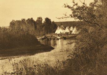
The completion of Yellowtail Dam on the Bighorn River in 1967 cut off historic flows of warm, turbid water to the Yellowstone River. People have lived along the lower Yellowstone and its tributaries for thousands of years, attracted by the area’s abundant water and plentiful fish and wildlife. Shown here: a 1908 photograph of an Apsáalooke (Crow) encampment on the Little Bighorn River by Edward S. Curtis.
into fields or left stranded in the ditches.
Another major development was the completion, in 1967, of Yellowtail Dam on the Bighorn River. Built to control flooding and generate hydropower, the dam vastly reduced the flow of warm, turbid water that attracts spawning pallid sturgeon, paddlefish, and other species. Though cold water from the dam’s base has created the Bighorn’s world-class trout population, biologists say the river’s contribution to the Yellowstone’s warmwater fishery has been greatly reduced.
Riprap and levees are another problem. For decades railroads, municipalities, and farmers have built shoreline dikes (levees) to prevent flooding on their property, and have lined banks with boulders (riprap) to lessen erosion of rail beds and irrigated cropland. But by narrowing the river, the cum ulative effect of hundreds of shoreline reinforcements increases water speed and energy, leading to greater flooding and increased erosion downstream. —Tom Dickson
AS CLARK SAW IT The lower Yellowstone meanders past cottonwood forest, sagebrush steppe, and cropland along its 600-mile route to the confluence with the Missouri. Des pite diversion dams, non-native fish species, and growing recrea tional use, the river still looks much like it must have looked in 1806. That’s when Captain William Clark carved his signature at Pompeys Pillar before continuing with his men downstream to meet the rest of the Corps of Discovery on the Missouri River in today’s North Dakota.

PEAK PLEASURES

A desire to keep lists and explore high elevations drives peakbaggers to reach one summit after another.
BY TED BREWER
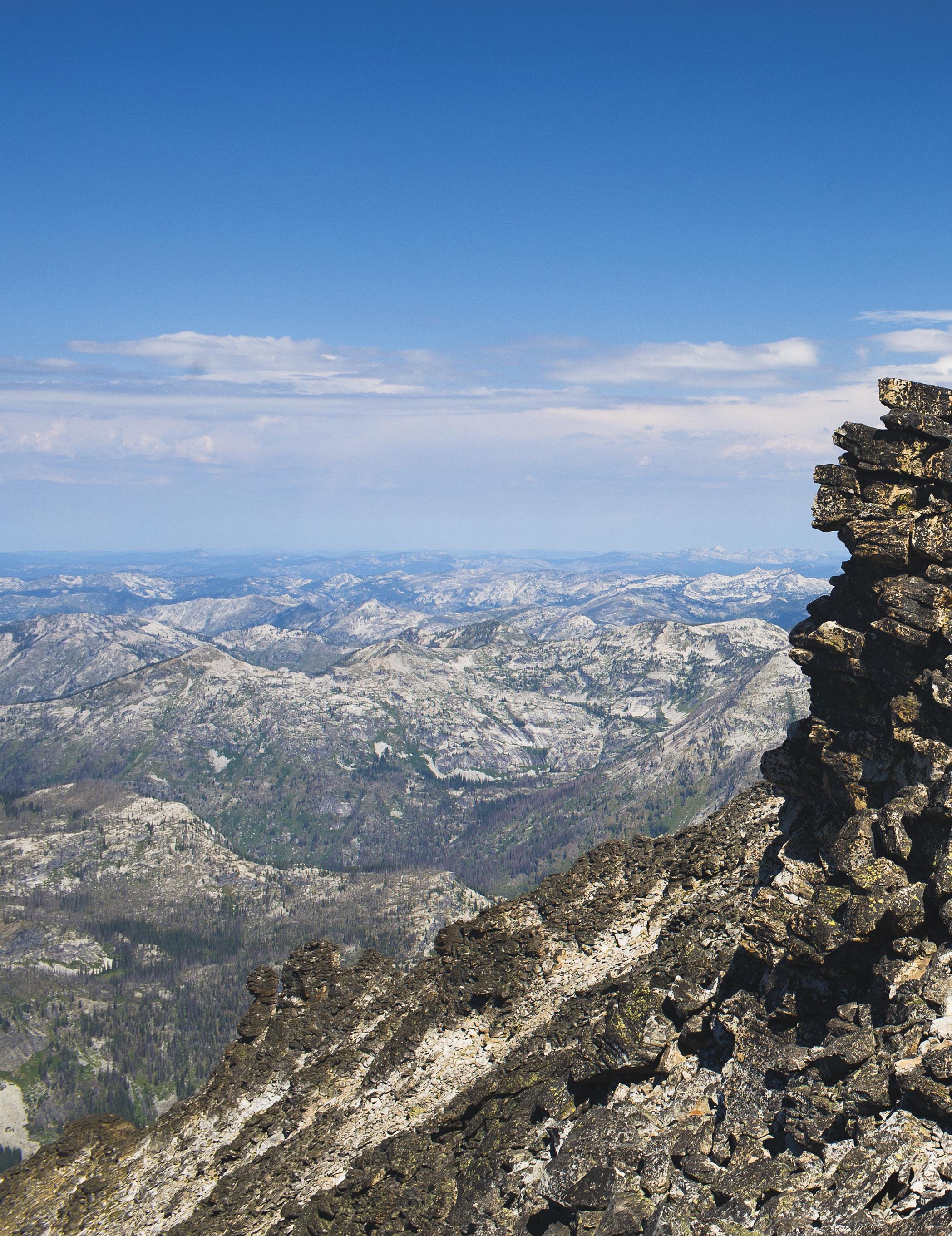

ALMOST THERE An intrepid climber reaches the summit of 9,983-foot El Capitán, the second-tallest peak in the Bitterroot Mountains and a goal of many peakbaggers.
Cedron Jones takes a few nimble steps up a jagged rock outcropping and thrusts himself to the summit of Sheep Mountain, a semi-forested peak 10 miles south of Helena topped by granite domes, spires, and towers. Euphoria shows in his face as he takes in the panoramic view. It’s a rich payoff for hiking up a mountain that’s only about 6,000 feet in elevation and requires just 45 minutes for him to ascend—a walk in the park for this veteran climber. The view encompasses a huge swath of the surrounding Boulder Batholith, nearby Skihi Peak, the Helena Valley, and the Big Belt Mountains.
His sure and steady clip up Sheep Mountain’s rigorous incline makes it apparent Jones has topped his fair share of peaks. The 72-year-old Helena resident has hiked to the top of, or “bagged,” more than 2,000. As the author of Peakbagging Montana: A Guide to Montana’s Major Peaks, Jones is one of the leading promoters of peakbagging in Montana.
“I love it,” he says. “You get up high and see the lay of the country. But there’s no doubt it is compulsive behavior.”
Compulsive, because peakbagging is about more than just summiting mountains; it entails compiling, adding to, and checking off peaks on a list. Typical lists are those of the highest peaks in a state or county, the highest peaks in a certain mountain range, or all the peaks higher than a certain elevation—such as the “14ers” in Colorado or the “4,000-footers” in the Appalachians. Once peakbaggers check off all the peaks on one list, which may take years or even decades, they start another.
Though not as technical, risky, or physically demanding as mountaineering—which often requires ice axes, crampons, and ropes—peakbagging is no leisurely stroll. These high-altitude hikes require strong legs and often the use of hands on steeper sections. The ability to read topo maps and terrain is essential because trails are often faintly marked or nonexistent.
Peakbagging also turns hikes into what Jones calls a “quest” to reach the summit of as many peaks as possible. Often, the peaks are obscure and come to a hiker’s attention only because of a book like Jones’s or a website such as peakbagging.com. “I’m climbing peaks now in Montana and other western states that most people have never heard of, some that don’t even have names,” Jones says.
A question of prominence In the 1980s, while managing species data for the Montana Natural Heritage Program, Jones pored over just about every topographic map of the state and came up with a list of the 100 highest peaks in Montana. He wanted to hike every one. It took about 20 years, but he bagged them all. He next tackled a list of all 10,000-footers in Montana. He recently reached the last of those 340 summits and is ready for another challenge.
Compiling a list of peaks to bag can be nearly as challenging as the climbing itself. Though there’s little question of what the highest peak in any given state, range, or area is, determining which peaks are the second highest, third highest, and so on is highly subjective.
Consider a mountain range and all the Ted Brewer is a writer in Helena.
DETAILED ACCOUNTS In addition to maintaining lists of peaks, Cedron Jones of Helena keeps exhaustive records of climbs dating to the 1970s. “I still refer to them when planning to re-climb a peak or bag a new one in that area,” he says.

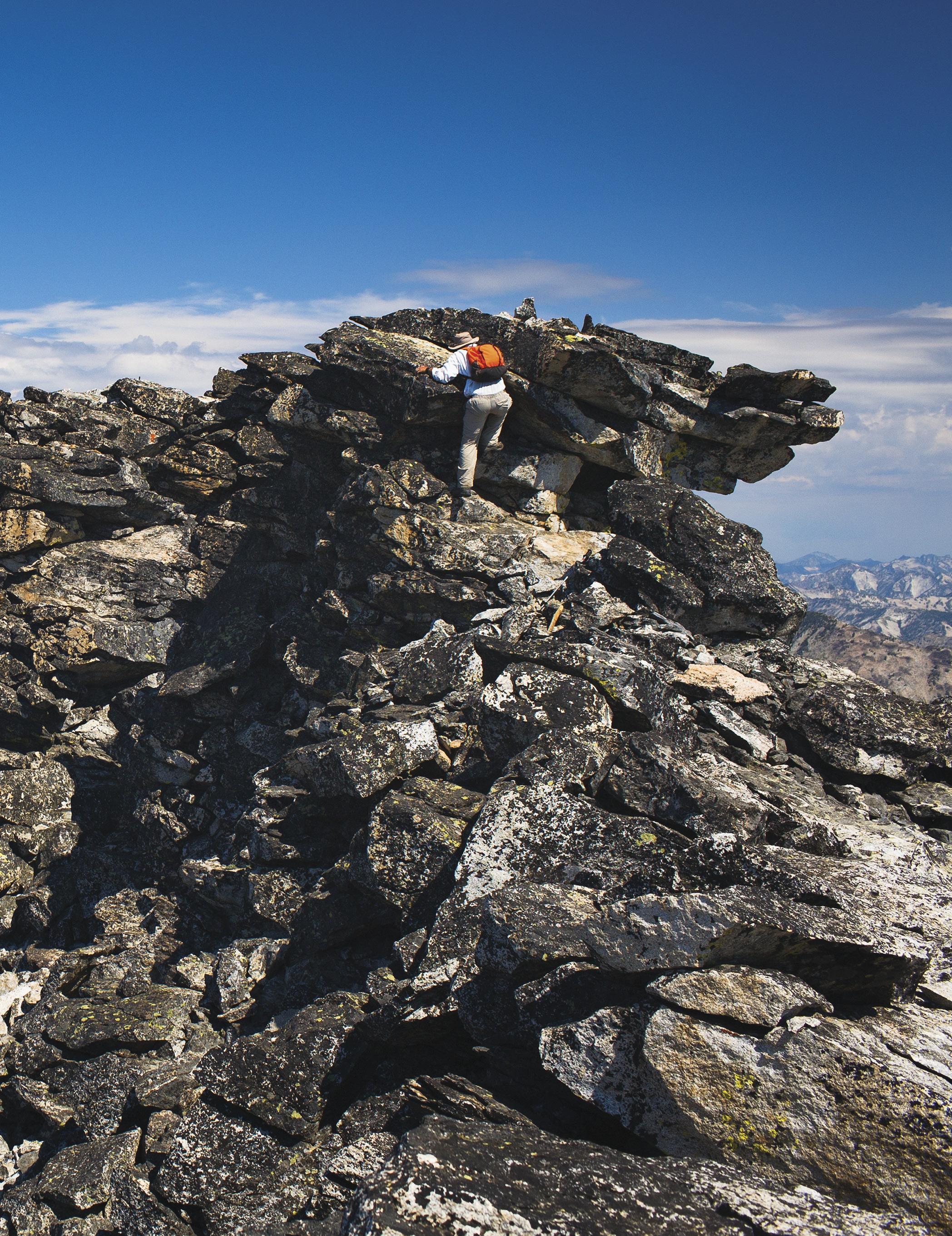
KING OF THE WORLD A climber expresses his selfworth after bagging 8,323- foot Point Saint Charles Peak in the Mission Mountains.


high points along its outline. Some points may be inconsequential protrusions, or “subsummits,” on the sides of true peaks. Others may contain just enough “prominence” to qualify as another individual peak and merit listing, even if that high point has no name (and often it doesn’t). Prominence is a term that represents the elevation of a summit relative to the surrounding terrain. The prominence of a peak is the height of its summit above the lowest contour line encircling it but no adjacent higher peak. Jones uses 400 feet of prominence as his standard of determining what does and doesn’t constitute an individual peak. Some climbers use 300 feet, while others require as much as 1,000 feet before they consider a protrusion a true peak.
A certain amount of prominence is also used by cartographers to determine if a peak is an independent mountain or just a subsummit (what Jones calls a “blip”). Like many avid peakbaggers, Jones has created lists of peaks that may not be high in elevation but are still worth bagging because of their prominence. Montana is packed with world-class mountain prominence, even though the state’s tallest peaks are lower than those in higher-elevation states like Colorado or California. For instance, McDonald Peak, the high point of the Mission Range, has a modest elevation of 9,820 feet. But its whopping 5,640 feet of prominence has attracted many peakbaggers to its summit.
When Jones realized he could create his list of peaks based on prominence rather than conventional elevation, “it opened up a whole new world for me,” he says. “All of a sudden, peaks I’d never even noticed, never knew existed because they were so low—4,000 feet or whatever— were suddenly in my consciousness. So I started going out and bagging those.” Over the next ridge Others share Jones’s obsession to conquer high places. Jim Williams, FWP’s regional wildlife manager in Kalispell, reached the top of his first peak in 1976. He has been keeping a list of bagged peaks ever since. That tally now includes more than 100, almost all in Montana. “I’ve always had a cur iosity to see what’s around the next cor-
ner or over the next ridge,” he says. Often, Williams is looking for animals. The biologist says he has spent countless hours on summits tallying mountain goats and bighorn sheep as part of FWP wildlife population surveys. He notes that alpine peaks are also excellent places to encounter pikas, hoary marmots, ptarmigan, and, if he’s lucky, wolverines. For Williams, peakbagging is a family affair. He and his wife, Melora, have been taking their two (now) teenagers to mountaintops since the kids were barely able to walk. Many hikes require scrambling across scree fields and boulders to find missing alpine trails. “The more remote, the better,” Williams says. While other parents show off pictures of their children at Disney World, Williams loves sharing photos of his family sitting atop Mount Oberlin, Mount Reynolds, and other peaks in Glacier National Park. A member of the Glacier Mountaineering Society, Williams says that when he retires he wants to hike to the top of the park’s other five 10,000-footers (adding to 10,014-foot-high Mount Siyeh, which he has already bagged). He also wants to summit the highest peaks in every range of western Montana—all of which he’ll duly add to his list, of course. “It’s like the life lists that birders keep,” he says. “Peak lists help people remember their days afield. They trigger memories of hard-earned climbs in special places.” Sitting atop Sheep Mountain, staring across the shaggy hills of the Boulder Batholith toward a Understanding “prominence” hazy Helena Valley, Jones recalls a time when he could remember In the diagram above, showing peaks on an island, prominence is every peak he bagged and the represented by the vertical lines. That distance, in feet, is measured route he took to the top. He ad-from a peak’s summit to the lowest contour line encircling it but not a nearby higher peak. Let’s say the prominence of A is 1,000 feet, B is 200 feet, and C is 700 feet. Under his criteria, Cedron Jones mits that some hikes are now starting to blur together, despite would consider A and C as individual peaks but not B, which he’d his detailed records. Even so, the classify as a “blip” (subsummit) of C. The notion of prominence is septuagenarian continues to not easy to grasp. For a detailed explanation, visit peaklist.org. create new lists of peaks to climb. For him and his fellow peakbaggers, there’s always one more summit around the corner. “Some people have to have their garden just so. Some people have to keep the house clean,” Jones says. “I have to go for a hike, and it’s sure nice if there’s a peak in it.”
A
B
“I love it. You get up high and see the lay of the country. But there’s no doubt it is compulsive behavior.”—Cedron Jones, 72 C MONTANA OUTDOORS CLOCKWISE FROM TOP LEFT: MARK SHAPLEY; ANITA STRAWN DE OJEDA; DEE LINNELL BLANK; JOHN LAMBING; MACNEIL LYONS; DAVID ANDERSON ; CATHRINE L. WALTERS; JEFF HANDLIN; DEE LINNELL BLANK

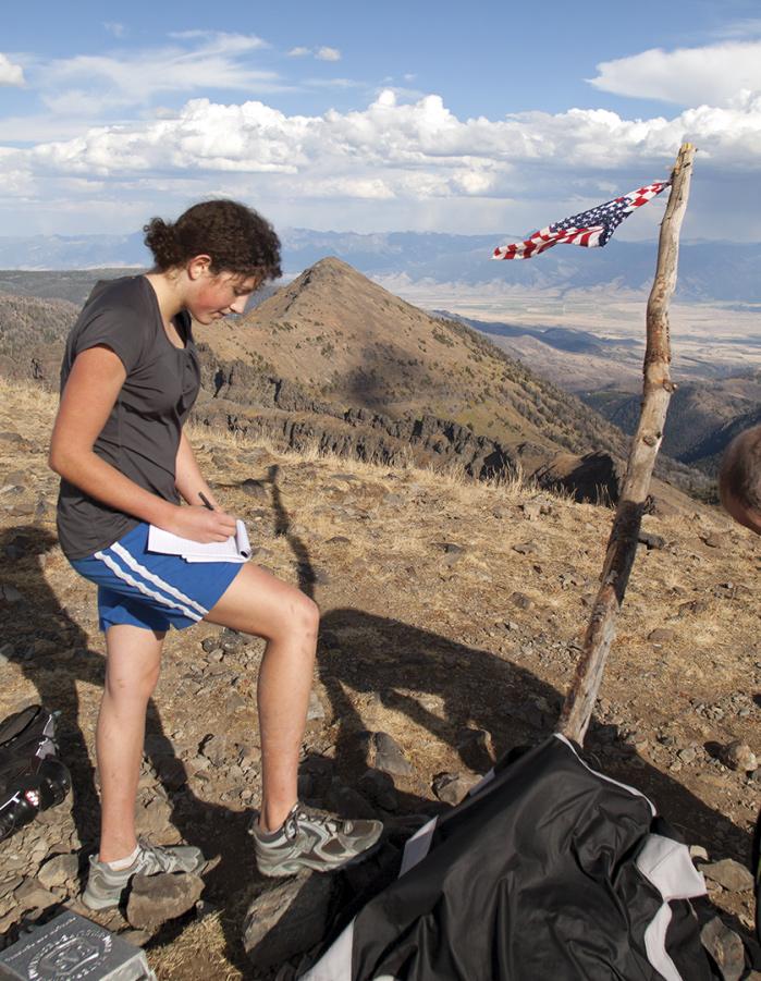

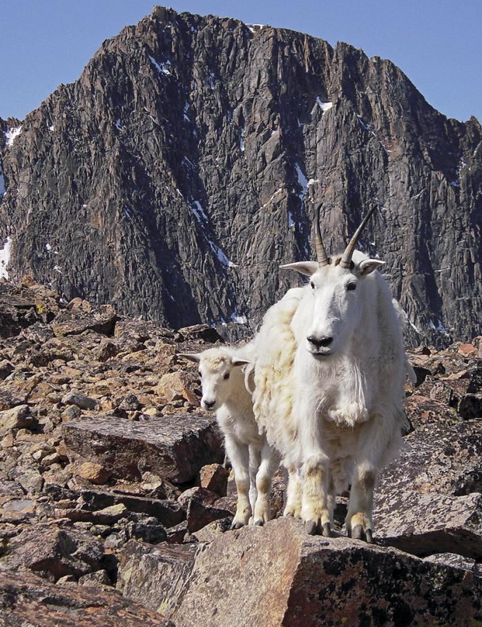
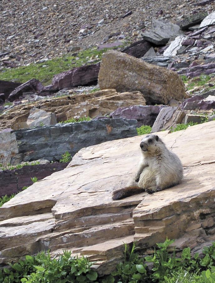
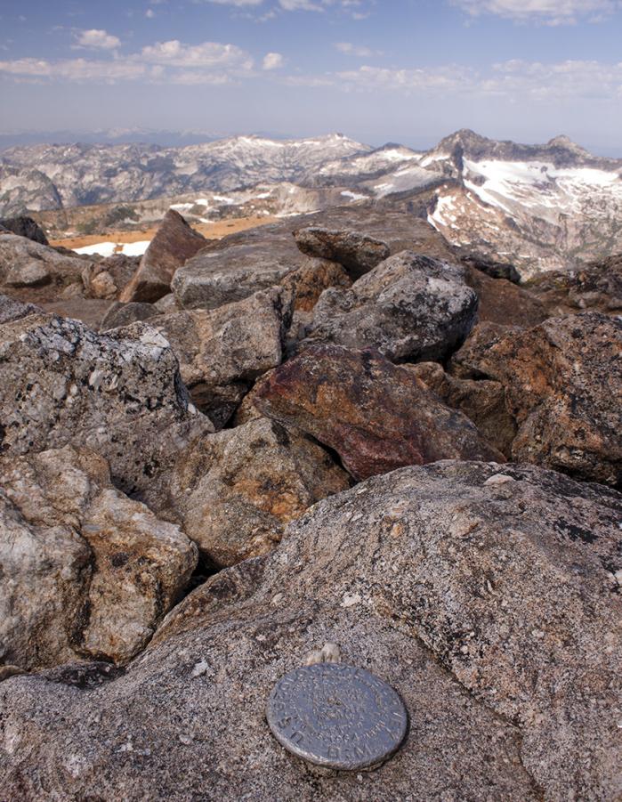
PEAK PERFORMANCE In addition to getting fit and seeing alpine wildlife, peakbaggers also take in some of the best views Montana has to offer. Many say the scenery alone is worth the oftengrueling effort of reaching a high rocky summit. Clockwise from top left: taking notes after bagging Bald Peak (10,180 feet) in the Gallatin Range; a National Geodetic Survey benchmarker atop Saint Mary Peak (9,351 feet) in the Bitterroot Mountains; photographer John Lambing cautiously peering over the lip of the Mount Siyeh headwall, 4,000 feet above Cracker Lake in Glacier National Park; a peakbagger atop a petrified tree stump near the summit of Rams horn Peak (10,296 feet) in the Gallatin Mountains overlooking Paradise Valley; a hoary marmot sunning itself; celebrating the summit of Pollack Mountain (8,325 feet) in Glacier National Park; curious mountain goats in the Absaroka-Beartooth Wilderness near Granite Peak (12,799 feet), Montana’s highest natural point; and a whitetailed ptarmigan in penstemon wildflowers at Piegan Pass, Glacier National Park.


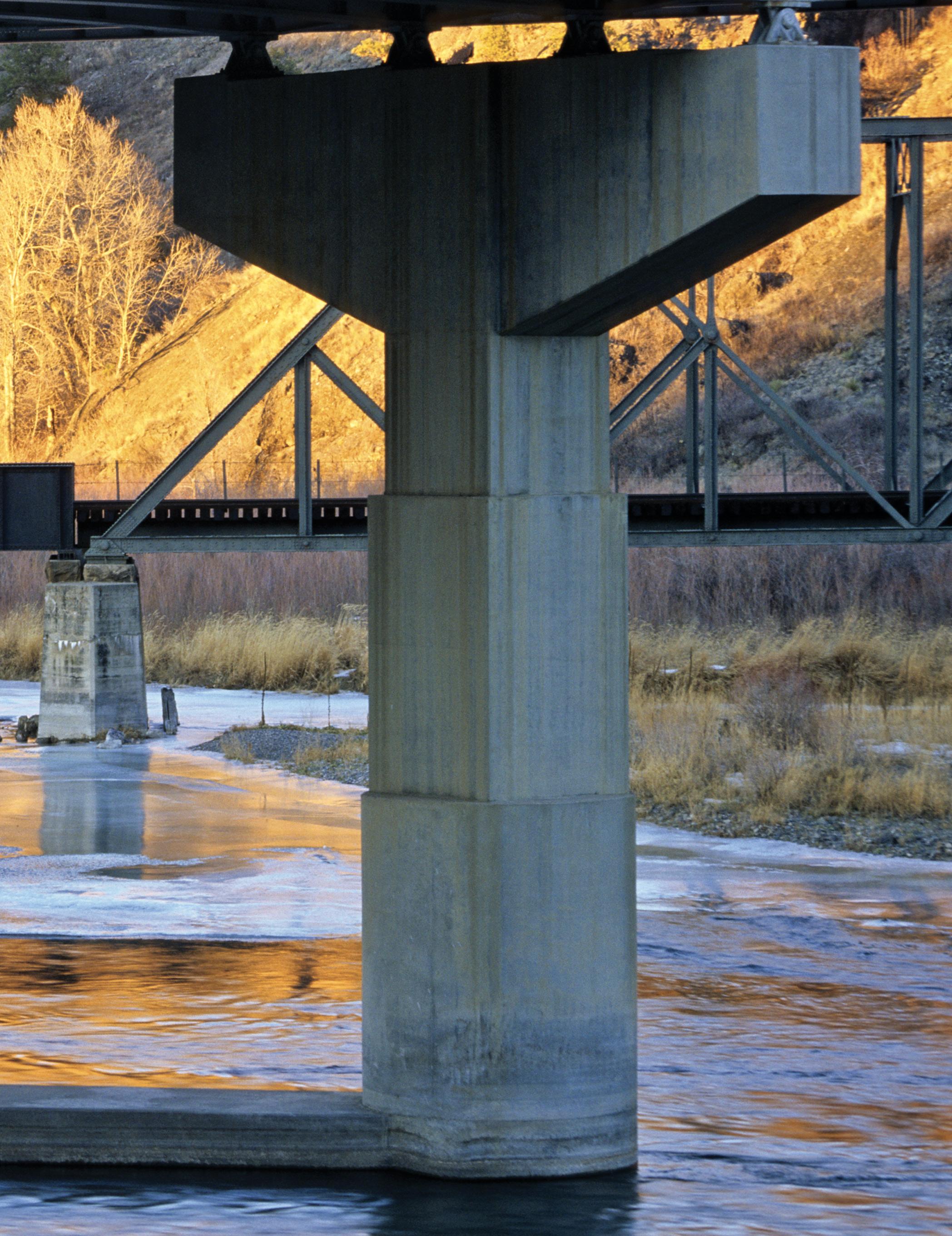
FREELY FLOWING A few miles north of Craig, the Missouri and Dearborn Rivers meet below a railroad trestle and a bridge carrying freeway traffic on I-15. This blue-ribbon stretch of trout water shows how transportation systems can coexist with fish habitat. Montana streams gained their first protection from damage caused by new highways, railways, and other development in 1963. Photo by Steven Akre.

Celebrating the Anniversary of 50th Montana’s Stream Protection Act

BRIDGING THE DIVIDE

Fifty years ago, Montanans came together and decided that streams were worth saving.

BY TOM DICKSON

very time I cross a bridge spanning a river or stream, I give a little cheer, because that structure of steel and cement represents a victory for fish. It wasn’t always so. For decades trout, sturgeon, sauger, and other species were on the losing side of Montana highway construction.
That’s because when it comes to designing roads, the straighter the better. Straight routes are safer for drivers and cheaper to build and maintain. Every curve means increased costs and potential for accidents.
When it comes to rivers, the opposite is true. A ruler-straight stream has little of what fish require, while curves, or “meanders,” create habitat—holes, riffles, and spawning sites—and contain more total miles of water.
There’s no question Montanans need roads to move themselves and goods across the state’s wide expanses. Yet they also cherish their beloved streams and rivers, part of what the Montana constitution calls “the quiet beauty of our state.”
Fifty years ago people realized, for the first time, they might not be able to have both.
Fishing waters took a beating during much of Montana’s early history. First came the railroads of the late 1800s, which required straightening many stream stretches to facilitate train traffic. Then came the go-go road construction years following World War II. When Congress passed the Federal Highway Administration Act in 1956, states received federal funds to build the Interstate Highway System, including I-15 and I-90 through the Treasure State. That pushed highway construction into overdrive.
By this time, fisheries biologists with what was then the Montana Department of Fish and Game already knew the state’s growing transportation needs were coming at an enormous price. “Montana’s best waters are gradually disappearing . . . whole channels are being changed by the road builders,” read a 1955 department editorial in its magazine, Montana Wildlife. Hoping to save the best of the best, in 1959 biologists designated a list of “blue- ribbon” trout streams containing premium productivity, public access, and aesthetics. Then, in 1961, fisheries officials devised a three-part stream preservation strategy (rumored to be hastily sketched on a napkin): protect physical habitat, preserve water quality, and maintain water quantity.
The first step of the plan was to find a way to reduce harm to streams from road and highway construction. That required documenting the damage.
The following year, the department conducted a study of 13 streams in western and central Montana. Biologists measured the amount of channel and bank alterations— including channelization, riprapping, and removing underwater habitat such as logs and gravel—and compared trout numbers before and after development. The results, issued in a 1963 report, were startling.
For instance, after a portion of Flint Creek, near Philipsburg, was channelized in 1957, the number of large trout declined by two-thirds. On Rock Creek, near Red Lodge, the trout population dropped 75 percent after channelization. Overall, biologists found more than three times as many catchable trout in natural stretches as they did in altered channels. And total stream length was reduced by half—from 137 natural stream miles to 69 miles of manmade channels—mainly from road building, railroad construction, and agriculture. “The manhandling of our cold water streams is of immediate concern,” wrote the report’s co-authors, fisheries chief William Alvord and biologist John Peters, who noted that “most changes could have been done without damaging the streams.”
Bring us into the planning stages earlier, the biologists urged, and we can find ways to keep new roads from harming trout waters.
Roads can coexist with streams when not built too close to the natural waterway. But when roads are routed through narrow canyons, there is less room for separation. One option, done before 1963, is to straighten, or channelize, the stream so it runs along the road. Cheaper to build, but bad for trout. Another option, more frequent after 1963, is to build bridges that allow roads to span portions of existing meandering streams. Good for trout, but more expensive to construct.
1963–2013
Conflict in the canyons
Roads generally don’t harm streams when the two are kept apart. But western Montana’s topography often can’t accommodate that separation. Over millions of years, moving water eroded canyons through mountain ranges, creating natural human transportation routes—from Indian trails and stagecoach lines to railroads and highways. The narrower the canyon, the more potential for conflict between roads and streams.
Road builders in the early 1960s opted for straight routes whenever possible, explains Steve Kologi of Helena, a road design engineer at the time with what was then the Montana Highway Department. “We were trying to get the most road we could for the least amount of money, while still ensuring public safety,” he says. To fit a road through a narrow canyon, highway engineers often channelized the stream so the two could run side by side. Unfortunately, straightening a serpentine stream harms fish. It lessens total stream miles and eliminates habitat such as pools, undercut banks, and spawning areas created by naturally meandering waterways.
Straight channels also increase current speed, creating more erosion and flooding problems downstream.
In January 1963, several Fish and Game staff presented the department’s findings about channelization and other stream alterations to civic groups, the Montana Wildlife Federation, and other organizations. Among the Montanans alarmed by the study was Harry Mitchell, a young dairy farmer in the Great Falls area. Mitchell was also a member of the Montana Junior Chamber of Commerce, a civic group (also known as the Jaycees) comprising members in their 20s and 30s. “It really got my attention,” says Mitchell, who later became a multiterm Montana senator and county commissioner. “And it didn’t take much to convince other members. It seemed so logical to all of us that we had to protect these trout streams we were all so proud of.”
The Jaycees, led by Mitchell and the group’s president, Harrison Fagg, lobbied lawmakers during the 38th legislative assembly to pass a stream conservation bill authored by Democrat Senator Robert Durkee and championed by Republican George Darrow. Many legislators were already aware of the growing conflict between the Highway Department and Fish and Game, which one reporter called an “undeclared war.” Particularly contentious at the time was construction of I-15 along Wolf Creek Canyon. Running through the narrow gorge was Little Prickly Pear Creek, a popular trout stream and a major spawning tributary to the blueribbon stretch of the Missouri River below Holter Dam. Central and eastern Montana legislators regularly passed though the canyon while driving between the state capital and their home districts. No doubt many noticed the bulldozers and cranes turning parts of the scenic stream into a bare ditch. The bill, known as the Montana Stream Protection Act, passed by a two-thirds bipartisan majority. It established a state policy that Montana’s fishing waters “are to be

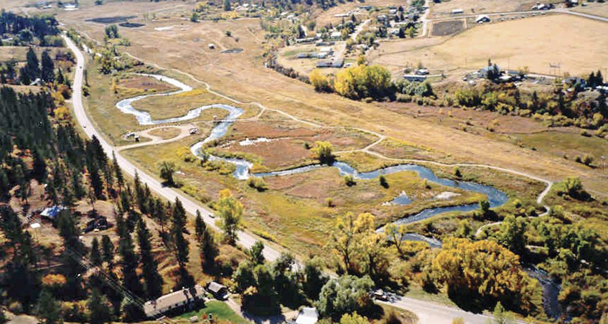
CHANGING CHANNELS Big Spring Creek in Lewistown was channelized in the early 1900s to make room for a railroad line. The above photo shows a later-built road next to the channel, with the original undulating channel still visible. In the early 2000s (below), FWP restored the stream to its historic course, bringing back the curves and bends that produce fish habitat.
protected and preserved...in their natural existing state except as may be necessary and appropriate after due consideration of all factors involved.” The law required state agencies, counties, and public municipalities to apply for a “124 permit,” administered by Fish and Game, for projects that would modify or change the natural shape of a stream or its banks.
It was the first state stream protection bill of its kind in the nation.
Seat at the table
Though the new law couldn’t alter federal projects, the U.S. Forest Service and other agencies soon acknowledged its significance by signing agreements to include state fisheries biologists in their road-planning process. “From that point on, we always had a seat at the table on any projects involving a stream,” says Ralph Boland, of Helena, who began working for Fish and Game as a fisheries biologist in 1960 and managed the department’s Stream Protection Act (SPA) Program from 1971 to 1983. Among the recommendations made by biologists when reviewing road construction plans: widen culverts through which streams pass, increase bridge spans to allow rivers more “wiggle room” to naturally meander, and replace channelization with bridges. “Our perspective was that instead of moving the stream from where you want the road to go, move the road to accommodate the stream,” Boland says.
With state law now on their side, biologists usually prevailed. According to Peters, the 1963 report co-author who was promoted the following year to manage the new SPA Program, plans for highway projects on the Beaverhead, Madison, Jefferson, Stillwater, Bitterroot, and other rivers were modified over the next few years to lessen stream damage. On I-90, biologists convinced the Highway Department to build two new meanders of the Clark Fork downstream from Drummond to replace two that had been cut off years earlier. In long stretches of St. Regis Canyon, the east- and west-bound lanes of I-90 were separated to avoid damaging the river bed. Two bridges downstream from Craig on I-15 were built to avoid destroying large bends of the Missouri River. “If done during the preconstruction planning stage, most changes were relatively easy to make,” says Peters, now living in Colorado.
While benefiting fish and anglers, the road revisions weren’t without costs. “Building or expanding a bridge was expensive,” says Kologi. “That meant fewer miles of highway we could build someplace else.” Bridges were also a safety concern, he adds, because the decks ice up more often than roads do.
Montanans were willing to pay that price. In 1965, the legislature voted overwhelmingly —with just a single dissenting vote—to make permanent the SPA, originally written to last only two years. “It was hugely popular,” says Mitchell. “No one wanted to vote against protecting trout streams in Montana.”
1963–2013
Concerns worked out beforehand
Fifty years after the original bill was signed, the Stream Protection Act is still safegaurding coldwater and warmwater streams, according to Beau Downing, current SPA coordinator for what is now Montana Fish, Wildlife & Parks. The department reviews roughly 480 permit applications each year, mostly from today’s Montana Department of Transportation (MDT). Disagreements occasionally take place, but five decades of discussions between highway engineers and fisheries biologists have greatly reduced conflicts. “We still have our mission and MDT has its mission, but a lot of our concerns will already be worked out before the permit application is even made,” Downing says. He notes that MDT now employs five biologists of its own.
Looking back a half century later, Mitchell says he can see how the 1963 act signaled a change in public attitudes toward both unbridled development and the need to protect the state’s natural resources. “I think Montanans had been taking their trout streams for granted,” he says. “Then all of a sudden the interstates came along, and for the first time people could see that those streams might not be around forever. It was a wake-up call. For many of us, saving those streams was simply the right thing to do.”
Montana Stream Protection Timeline: 1956–19 78
1956 Congress passes the Federal Highway Administration Act. 1962 Fish and Game begins a comprehensive study of 13 streams across the state. 1963 Controversy over construction of I-15 in Wolf Creek Canyon. 1963 Legislature passes the Montana Stream Protection Act. Legislation written to last two years. 1969 Legislature passes the Montana Water Quality Act.
1972 Congress passes the Clean Water Act.
1959 Montana Fish and Game designates “blue-ribbon” streams. 1961 State fisheries officials devise a three-part stream preservation strategy. 1965 Montana Legislature overwhelming approves permanent version of the Stream Protection Act. 1972 The newly ratified Montana Constitution includes a provision guaranteeing Montanans a “clean and healthful environment.” 1973 Legislature passes the Montana Water Use Act. The law specifically defines, for the first time, fish and wildlife as a beneficial use of state waters and authorizes maintenance of minimum flows for fish.
1975 Legislature passes the Montana Natural Streambed and Land Preservation Act, which requires private landowners to apply for a “310 permit” if considering stream alterations. 1978 Montana Board of Natural Resources and Conservation rules that 5.5 million acre-feet of instream flows on the Yellowstone River and 67 tributaries should be perpetually reserved for the good of fish and wildlife.
Fisheries foresight
IN 1961, MONTANA FISHERIES OFFICIALS came up with a threepart strategy to preserve the state’s rapidly disappearing trout streams: (1) protect physical habitat, (2) preserve water quality, and (3) maintain water quantity. Remarkably, they and other conservation-minded Montanans were able to fulfill that vision in little more than a decade.
After the Stream Protection Act of 1963 (made permanent in 1965), the state expanded stream habitat protection in 1975 with the Natural Streambed and Land Preservation Act. The new law required private individuals and organizations to obtain a “310 permit” before undertaking a project that would modify a stream. Authority for permit approval was given to conservation districts, with recommendations coming from landowners and local fisheries biologists.
To preserve water quality, groups like Trout Unlimited and the Montana Wildlife Federation helped pass the Montana Water Quality Act in 1969. The law established enforceable standards for clean surface water and groundwater, designating maximum allowable levels of arsenic, nitrates, and dissolved heavy metals, and making it illegal to, among other actions, pipe sewage into streams.
As for maintaining water quantity, in 1973 the Montana Water Use Act authorized maintaining minimum flows in streams for fish and wildlife, which it included as a beneficial use of state waters. For the first time, Fish and Game could apply to the Board of Natural Resources and Conservation (seven citizens appointed by the governor) to reserve water for the good of fish and wildlife.
The law was first put into action on a large scale in 1978, when the board ruled that 5.5 million acre-feet of instream flows on the Yellowstone River and 67 tributaries should be perpetually reserved for the good of fish and wildlife. The ruling helped defeat a proposal to divert one-third of the river’s flow to accommodate coal development in eastern Montana and Wyoming, and has since restricted water removal for irrigation during critical low-water periods on several major rivers.
Though Montana has passed subsequent environmental conservation legislation, the laws enacted during the decade spanning 1963 to 1973 did more to protect the state’s world famous fishing waters than any before or since. “Looking back, you realize the foresight those guys had back then,” says Larry Peterman, FWP fisheries chief during the 1990s. “First with the blue-ribbon stream designation and then the [13-stream] study, they were building a public awareness of Montana’s streams that, until then, had been largely taken for granted.” Never before had Montana considered streams as ecological entities and not just channels that moved water around, adds Peterman. “It was the beginning of the groundswell of public opinion, which continues to this day, that says, ‘Hey, stop messing with our streams.’” n
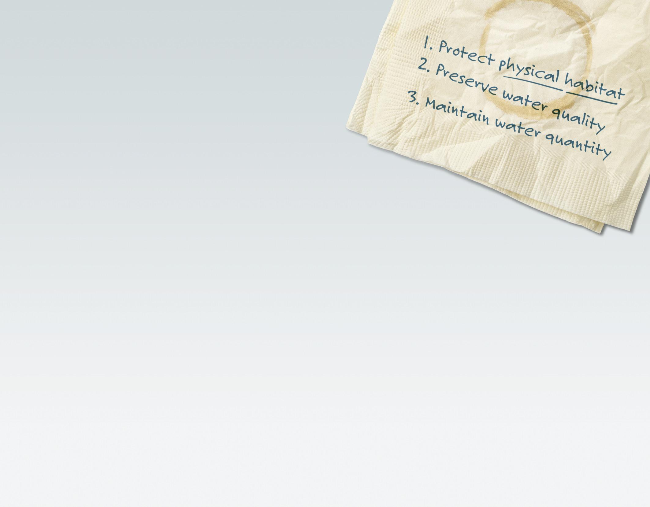
HALF A CENTURY The year 2013 marks the 50th anniversary of legislation that has protected hundreds of miles of coldwater and warmwater streams across Montana. Shown here: rainbow trout in a tributary of the upper Blackfoot River.


