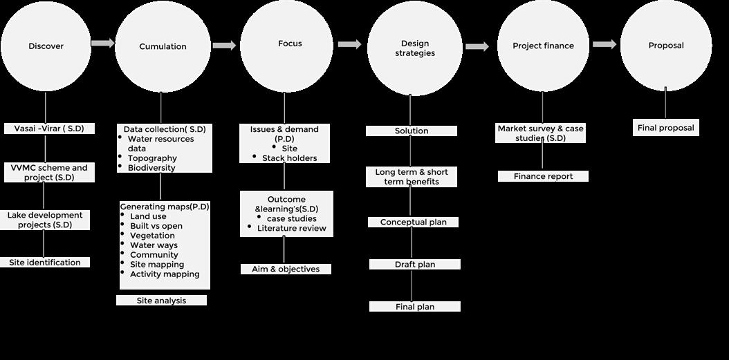
Urban design and developmentCapstone
Students learn to collate inferences in a multidisciplinary manner to find solutions to various urban problems across four verticals: Society & People, Environment & Ecology, Technology & Networks and Management & Governance. The distinct but interrelated modules are carefully curated as a convergence of two or more verticals, to accord stu dents with knowledge of the complexities in urban areas.
The pedagogy facilitates hands-on learning through real-life situations, cases and experiences. Building on this, the stu dents of Urban Design and Development are required to undertake a capstone project executed over two semesters in the second year. The project provides the students with an opportunity to connect and work with real stakeholders, funding agencies and implementing authority, ensuring ex tended association with them through the project life cycle in the form of professional internship.
Barmale Uttareshwar
and
lakefront development 13
01 Introduction
Page- 19-28
Background City Location
About Vasai- Virar
Impact of Urbanization
Need of project
Site location
Aim& Objective
Scope & Limitation
Methodology
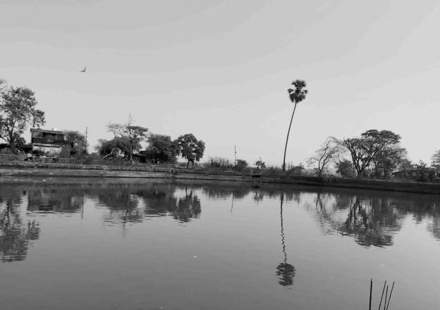
Barmale and Uttareshwar lakefront development
BACKGROUND:
Lakes and bodies of water, also known as wetlands, are one of the most productive ecosystems that contribute to ecological sustainability, cre ating the necessary links between land and water resources. Though relatively small in size, lakes perform significant environmental, social and economic functions, ranging from being a source of drinking water, recharging groundwater, acting as sponges to control flooding, supporting bio- diversity and providing livelihoods. Water in lakes is an easily available source of water for the needs of many sectors of the economy such as agriculture, domestic and industrial. These water bodies, whether man-made or natural, freshwater or brackish play a very vital role in maintain ing environmental sustainability, particularly in urban environments, especially in today’s context when the cities are facing the challenges of un planned rapid growth. The quality and hydrological system of these lakes and wetlands is directly dependent on the integrity of their watershed. In the last two decades, rapid urbanization, combined with unforeseen human activities, has seriously altered the global wetland ecosystem. Changes in land use and land cover (LULC) in wetland watersheds impact lake water efficiency and water quality. Apart from LULC changes, the inflow of untreated domestic wastewater, industrial effluents, dumping of solid wastes and rampant encroachments of catchment has threatened the sustenance of urban wetlands. (Bellandur and Varthur Lakes Rejuvenation, CSE, 2017)
At present, in India, lakes and wetlands are in extremely bad shape and are in varying degrees of environmental degradation. Despite knowing their environmental, social and economic significance, growth has neglected and destroyed these water bodies. Today these water bodies are encroached, full of sewage and garbage. Because of unplanned urbanization, much of the landscape around the lakes has been covered by im pervious surfaces. As a result, instead of rainwater, it is the sewage and effluents that are filling up urban water bodies. Their numbers of lakes are declining rapidly. For example, at the beginning of 1960s Bangalore had 262 lakes, now only 10 hold water. Similarly, in 2001, 137 lakes were listed in Ahemdabad city, and over 65 were reported being already built over (Excreta Matters, 2012).
In order to save this water bodies Indian government National Lake Conservation Programme under the Ministry of Environment and forests (MoEF) defines lakes as “standing water bodies which have a minimum water depth of 3m, generally cover a water spread of more than ten hec tares and have no or very little aquatic vegetation (Ministry of Environment and Forests, 2010).In India
The state of Maharashtra has a wide range of coastal and inland wetlands. These areas, such as backwaters, rivers, lakes, reservoirs, which are permanently saturated by surface or groundwater, play an important role in the state’s ecosystem and the wealth of natural resources. Wetlands support a range of coastal and inland aquatic plants and animals, as well as coastal and riparian biodiversity. These wetlands are attributed several benefits to the local environment, such as influence on the local hydrological cycle, climatic regime, water purification, flood control and coastal stability. In addition, these vital natural resources supports rich and diverse food chains for hundreds of animal species, including birds, both local and migratory, from within and outside India. Fishing in these wetlands is the main livelihood for millions of traditional fisheries communities. A wetland area in the 35 districts of Maharashtra state is estimated to be 1014522 ha as compared to the total geographic area of 307748 sq. km which accounts for 3.30% of the total geographical area of the state. The region of the largest wetland is a suburb of Mumbai (24.87%) (NWA: Maharashtra, 2010).
17
Mruga Raut Capstone project 2022
LOCATION:
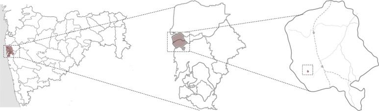
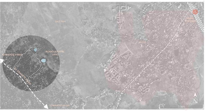
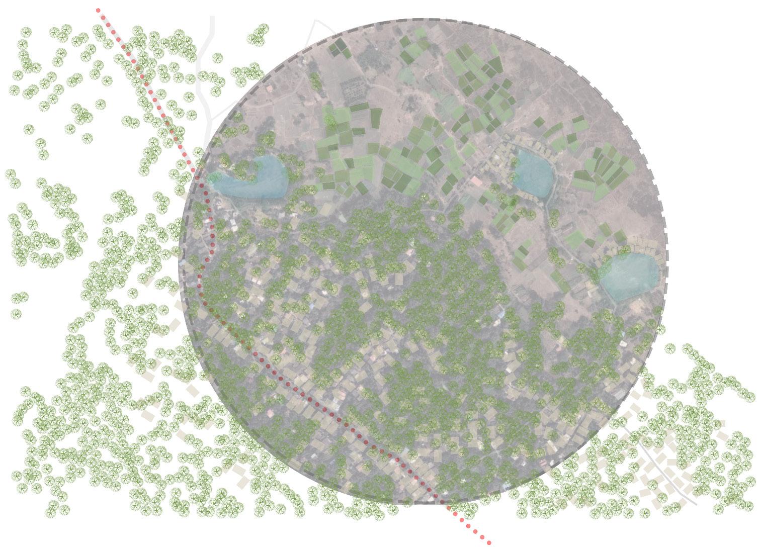
The Vasai Virar area is a suburb of the Greater Mumbai Metropolitan Area. It covers an area of approximately 380 square kilometers and is the northernmost part of the Mumbai metropolitan area. It’s a coastal area geographically bound by the Vasai Creek to the south, the Vaitarna Creek to the north, the Western Ghats in the east and the Arabian Sea to the west.
Maharashtra Mumbai Metropolitan Region Vasai-Virar
Figure 1 Location of Vasai- Virar
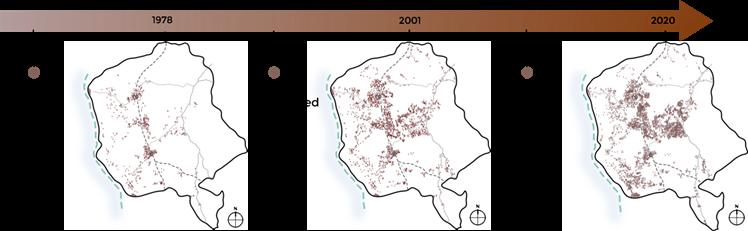
This region has been rapidly urbanized with an ever-increasing rate of population growth since the late 1970s. This occurred due to many factors like the continuous push effect of an ever growing Mumbai city, the application of land ceiling acts in Mumbai and also better connectivity provided by the Western Railway line to the region.
Figure 2 City evolution
ANANT NATIONAL UNIVERSITY
ABOUT THE CITY:
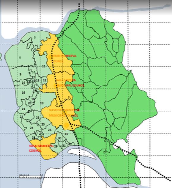
While today it is termed as the dormitory town of the Mumbai region, the area is also home to some industrial parks, cattle zones, agricultural areas, large fishing villages etc. Geographically the region can be seen in three parts. The first is the coastal green zone, the second is the eastern hilly zone and in between these two are the central lowlands where most of the urbanized part of the region lies today. Up to 2009, the region had four separate city councils: Vasai, Navghar-Manickpur, Nalasopara and Virar. In 2009, the state government decided to merge these 4 municipal councils with 53 other surrounding villages into one municipal corporation of Vasai-Virar. The city has seen significant population growth since 1981. Since 1970 the planning authorities of the region have been carving out more and more land for urbanization in the area, mostly in the third zone which also happens to be around the railway line. But even today most of the area of the region, about 78%, is not in development as per the development plan in place and are categorized as “Green Zone”, “Plan tation Zone” and “No Development Zone”. The eastern coastal zone is mostly home to agriculture, plantation or fishing communities like the Kuparis, Saamvedis etc. But even these communities today are moving away from ag riculture towards the service sector as well. The eastern hills are home to a few hill tribal communities. While the central urbanized zone is mostly home to people who have migrated in the last few decades due to lower cost housing available in the region and the opportunity of employ ment in the Mumbai Metropolitan region. People travel to places all over the MMR like Mumbai, Thane, Panvel, Navi Mumbai etc. for work while having their homes in Vasai Virar
 Barmale and Uttareshwar lakefront development
Figure 3 Council map of VVMC
Barmale and Uttareshwar lakefront development
Figure 3 Council map of VVMC
19
IMPACT OF URBANIZATION:
Water Supply (VVMC) in 2020
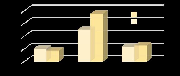
The rapid growth in the Vasai Virar has not only increase the urbanization 13% in 2017 to 15% in 2019 this has shown tremendous increase in the graph over last two years in this region.
The rapid growth of the city has led to decreasing the veg etation in the area from 75% to 55% the substantial fall of the vegetation has affected the city and the increased heat island effect in the region.
The area also have lost is identity of agriculture from producing Banana fruits and other vegetable have been de creasing from 25% to 23% (KRIVA, 2019)
This rise in population has put extreme strain on the re The increased concretization in Vasai – Virar has resulted in cutting-off of natural streams originating from the hills on the east and flowing towards the coast. These streams func tioned as a natural source of drainage to run-off water dur ing monsoons. The increased concretization in the area has resulted in cutting streams that acted as a natural drainage system. The sea-levels are also rising by 2-3mm every year. Every monsoon, 40% of the area gets inundated, which may increase to 60% in a decade, if similar concretization contin ues.( KRVIA,2019)
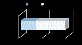
The region which provide more water to Mumbai is facing the water problem. The pressure on which is now very much dependent on water from various reservoirs around the area and still faces shortage of about 650 MLD.
Mruga
Figure 4 Impact of urbanization
Figure 5 Water supply and demand
Raut Capstone project 2022 ANANT NATIONAL UNIVERSITY
WATER SOURCES:

Barmale and Uttareshwar lakefront development
To address the water needs of Mumbai and the metropolitan region, several plans and schemes have been prepared over the years. The earliest schemes were in colonial times to address Bombay’s water requirements. Since then, there have been several plans drawn up for the region. These include the Survey of Water Sources for the Region con ducted prior to the RP 1970, the Feasibility report on Water Resources Study of Bombay Hydrometric area (1977) done for BMRDA by Kirlo skar consultants, the Water Resource Development Plan (1983): MMRDA submitted to the State Government for 2001and the latest being the Report of Committee for Finalization of Water Resources for MMR (excluding Mumbai),2005 (Chitale Committee Report). The Chitale Committee divided the MMR into 8 zones viz. Mumbai (Zone I), Mira Bhayander and Urban and Rural areas of Vasai Virar (Zone II), Urban and rural areas of Thane district in MMR (Excluding Mira Bhayandar and Vasai Virar)(Zone III), the water demand was estimated for 2011 was 7610 MLD and 11279 MLD for 2034, water norms considered were 200 LPCD for large urban towns (except Mumbai where it was consid ered 240 LPCD), 150 LPCD for small towns, 70 LPCD for rural areas, the Chitale Committee Report identified potential sources of water for development and recommended projects to be developed in future along with timelines. However, due to several limitations the development of water sources did not materialize as planned.(MMRDA plan, 2020)
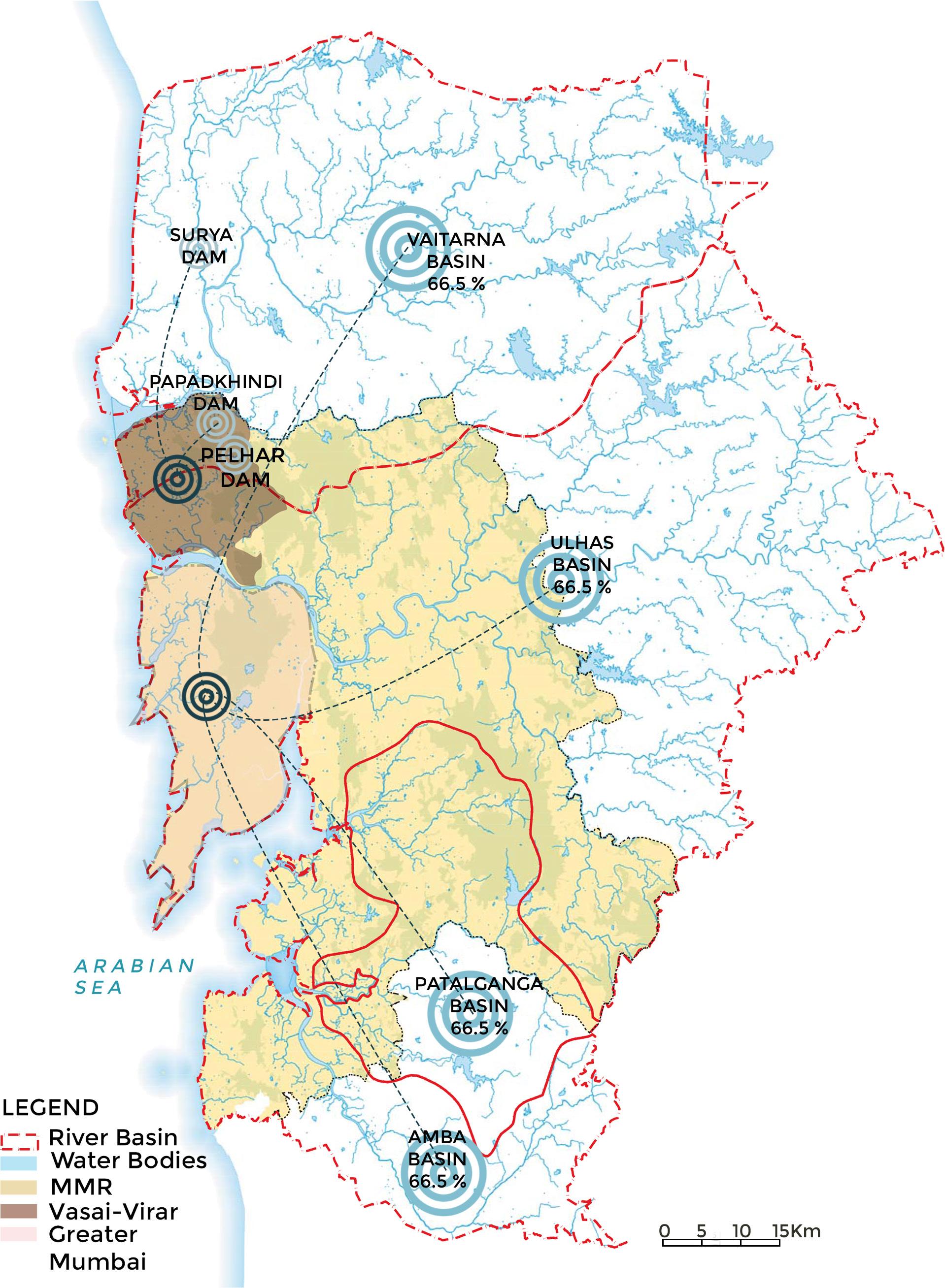 Figure Water resource
21
6
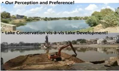
NEED OF THE PROJECT:
The rise in urbanization has made the Vasai-Virar belt more prone to flooding and has also resulted in the depletion of groundwater levels. This rise in population has put extreme strain on the re gion’s resources, especially land and water. In this scenario, the newly elected Vasai Virar City Municipal Corporation started the lake beautification project for a large number of lakes in the region. Many of the lakes in the area were not in a very healthy condition with varying levels of eutrophication and had become places for the dumping of garbage. These lakes formed a signif icant part of the hydrological system of the region. They helped keep the freshwater table high in the area and allowed agriculture to occur despite being close to the sea. The idea of the project was to spend about a 100crore to create a chain of lakes by undertaking works like “lake conservation” and “other develop ment works” around the lake. The primary argument for making such new beautified lakes by the VVCMC was the requirement of open spaces and places for recreation and leisure in light of the increasing population in the region. Its termed as “breathing

 Mruga Raut Capstone project
ANANT
Reviving
Figure 7 Ward plan of Vasai - Virar
Mruga Raut Capstone project
ANANT
Reviving
Figure 7 Ward plan of Vasai - Virar
2022
NATIONAL UNIVERSITY
100 crore for Lakes development in VVMC area Creating breathing space in the city
hydrological system Prohibition of Encroachment along lakes banks Restricting garbage dumping into lakes
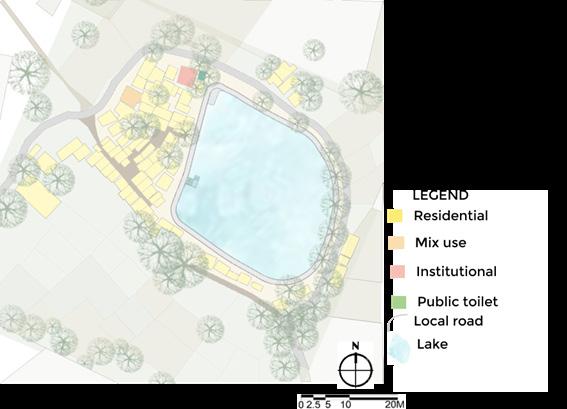
SITE SELECTION:


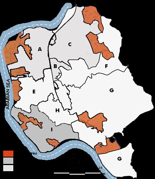
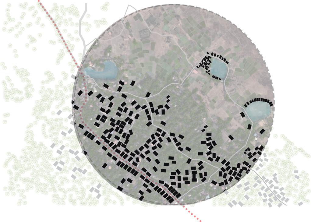
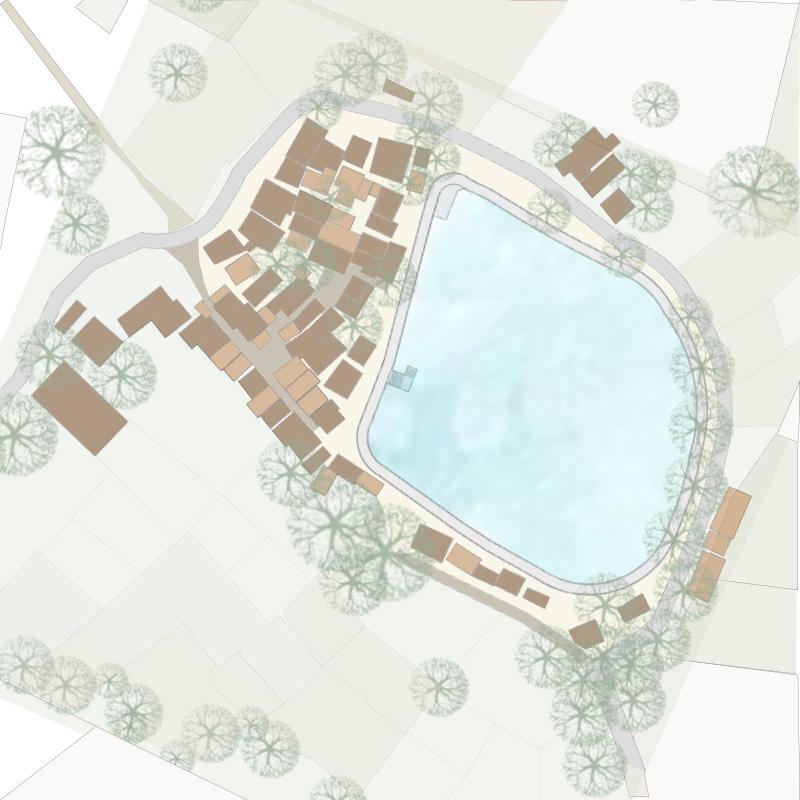
The VVMC has developed 20 lakes in different wards A, B &C. The next ward, Saloli is under the development where the three lakes are development; the Giriz Lake is under develop ment the proposal for the lake has been passed. Uttareshwar Lake has been proposed by the VVMC. The Barmale Lake is under the proposal. The Barmale and Uttareshwar Lake in the Saloli region face rapid urbanization, which may lead to depletion of these water bodies in the future.
The location of the two lakes, Barmale and Uttareshwar, is be tween the new and old settlements of the Vasai area. The lakes are in the urban periphery of the site. The lakes are linked with the neighborhood by a local road. The primary collector road name St. Francis road, which connects the vital center of the city, is 500 m from the lake. The future junction road is also the highlight for an area that will connect it to the town. The lake supports the economically weaker section leaving around eight and the agricultural land owners living in the neighbor hood.
 Barmale and Uttareshwar lakefront development
Location of three lakes
Land cover of I ward Green zone Plantation zone
Marsh zone Lakes Giriz Lake
Barmale Lake Uttareshwar Lake
Ward plan
Figure 8 Map of lakes
Barmale and Uttareshwar lakefront development
Location of three lakes
Land cover of I ward Green zone Plantation zone
Marsh zone Lakes Giriz Lake
Barmale Lake Uttareshwar Lake
Ward plan
Figure 8 Map of lakes
23
Mruga Raut Capstone project 2022
AIM OF THE PROJECT:
The aim of this project is to revitalize the Barmale and Uttareshwar lakes by activating edges.
OBJECTIVES:
• To analyze and understand the lake and neighborhood physical and social aspects.
• To propose water sensitive design along the lake precinct.
• Emphasize the urban design tools to connect lake with community
SCOPE AND LIMITATION
This project provides the scope to experiment with various scape as there are numerous activities involved. The challenge is to create harmony involving lake edge, community spaces, enclosed space, form, design, etc. The project offers the scope of designing spaces for Water Ghats, De centralized wastewater treatment, Kiosks, Seating, and deck space for instruction in all art forms. The project attempts to bring the entire tribes into a harmonious interdependence and to provide healthy learning and performing environment. This development will allow the community to interact with the outside world. This project will help us uplift and establish the weaker economic section, which will result in the up-gradation of their economy. The project will offer the scope for conserving the lake and its biodiversity. Culture and social activities are a part of the commu nity’s daily life, including this project. The idea is that lakefront development is a key to the future of the inclusive development of communities within the city. This project provides a scope of promoting this idea positively of water-sensitive design and the preservation of lake banks to enhance aquatic life.
The public area along the lake is limited: the private land and the argument among the owner for the ownership. The lake currently looks like the water storing tanks by the local Authority.
ANANT NATIONAL UNIVERSITY
Barmale and Uttareshwar lakefront development
METHODOLOGY :
25
02 Site Context
Page- 31-34
Site surrounding and impact
Site issues and problem identification
Stakeholder issues and demands
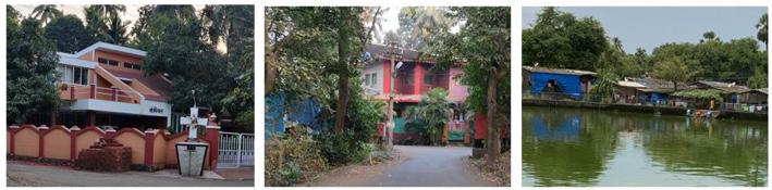
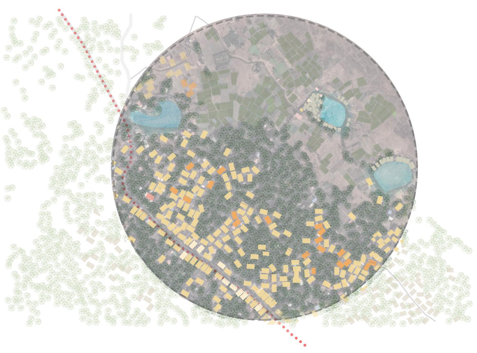
SITE SURROUNDING AND IMPACT:
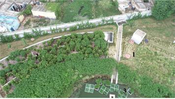
Figure 9 Site surrounding
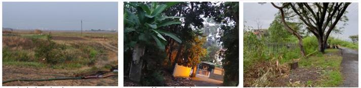
The cluster settlement around the lakes depends on the lake water. The lakes provide water to agriculture and help maintain the temperature of the area. The lakes are surrounded by farmland and the salt marsh that surrounds them. The impact of the fertilizers used in the farmland and the detergents used for washing clothes and utensils is changing the lake’s water quality. Groundwater is brackish due to saltpan in the neighbor hood— encroachment of the lake catchment by the urbanization due to transport-oriented development due to the western railway.
Mruga Raut Capstone project 2022 NATIONAL UNIVERSITY
ANANT
Barmale and Uttareshwar lakefront development
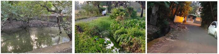
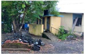
SITE ISSUES AND PROBLEM IDENTIFICATION:
The lake is in the center of urban development, most resident faces many issues as outlined below:
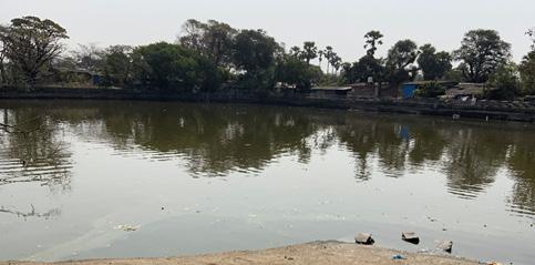
1. Eutrophication: It refers to the excessive richness of nutrients in a lake or other body of water, frequently due to run-off from the land, which causes a dense growth of plant life. This results in depleted levels of dissolved oxygen in water leading to a situation where other aquatic life forms cannot survive. Increased eutroph ication in the Barmale Lake has resulted in the reduced visual quality of the water body, problems of odor in the water, increased amount of toxins in water and loss in the effective surface area and storage capacity of the lake.
2. Anthropogenic Stress: Due to intense residential development all around the lake, there is considerable an thropogenic stress on caviar and other nearby lakes. This is further increased due to the uncontrolled inflow of dissolved particulate matter. Anthropogenic stress is one of the major causes to which the character of a lake is lost.
3. Siltation: Inlet drains to the lake, bring a lot of silt with them and over time this tends to settle down at the lake bottom. Also, there are cases where the surface runoffs bring a considerable amount of silt with them, which ultimately find the same fate. Over time, the depth of the lake reduces, resulting in a reduced water stor age volume. The lake which acts as a catchment for the whole region now holds a considerable amount of less runoff water due to a reduction in the overall volume.
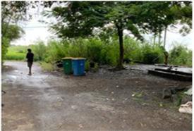
4. Improper Management: This Lake, though being a part of a residential local is neglected. Local people and residents are oblivious to the fact that this lake if properly maintained would improve the social and cultural value of the area. Mismanagement of the premises has resulted in garbage dumping along the edges with the uncontrolled inflow of drains.
5. Lack of lake profiling: There are several lakes around Vasai which face the same issues as the Barmale Lake faces. As different lakes have different characters, problems specific to Barmale Lake need to be identified first and solutions to those specific issues need to be addressed. This can be achieved through physical and social surveys.
6. Lack of Government Commitment: Government institutions lack knowledge about the importance of the lake in the area and the essence of conservation and management, owing to constraints in finances and a lack of adequate infrastructure. The direct impact on the lake in the surrounding areas.
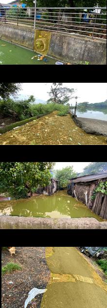
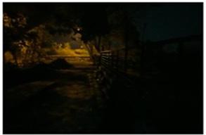
Figure 10 Inlet blockage
Figure 11 Garbage dumping
Figure 12 Clogged with garbage
Figure 13 Poor road condition
29
STAKEHOLDER ISSUES:
The reconnaissance survey was carried out around the lake, and people were present. Stakeholders found the central problem of drinking water, lake accessibility, and water quality of the lake. The majority of women in the nearby community faced issues regarding water quality, depletion, and eutrophication in the lake. Agricultural laborers also face the problem of water scarcity during summers. The road to access the lake is also an obstacle for the neighborhood community.
Figure 15 Stakeholder issues
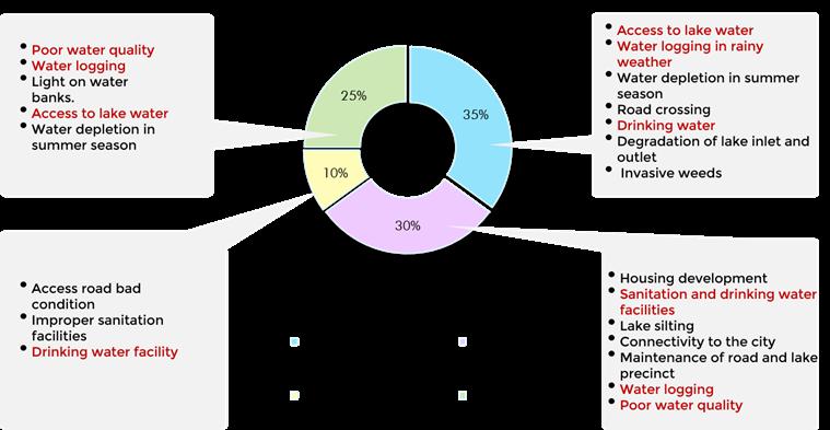
The people demand creating a socio-cultural space around the lake area. The place is more open to the people. Urge to revive the purpose of the lake. To design a space to accommodate all kinds of age groups and provides:
• Different activities like a play area for kids.
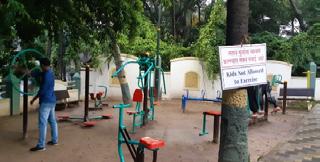
• An open gym for the young.
• A sitting place for the elderly. To create a space along the lake for celebrating the festival in the area. The community also demand a social space for gathering for social meeting and other purposes.
Mruga Raut Capstone project 2022 NATIONAL UNIVERSITY
ANANT
Barmale and Uttareshwar lakefront development
UNDERSTANDING URBAN LAKE AND SYSTEM:
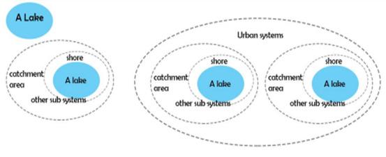
The urban lake is not an independent entity, but it reflects its water shed and a direct link between them. Studying this link is important because the lake condition is directly related to the state of the watershed. Critical to any lake ecosystem, the urban lake’s watershed is the surrounding land area that drains into that particular lake. Catchments are defined by topography, in which elevated areas flow into low areas. Generally, in urban lakes, runoff occurs through direct runoff from the land or through drains. Storm water that runs off from roads, pavements, rooftops, parking lots, and driveways flows to the street drains into underground catch basins and into the storm sewers that flow into lakes.(Urban lake: A reflection of its watershed,CSE,2020).
The urban lake consist of a lake catchment, a shore, a lake and other subsystem. Together the system makes the lake a wetland. The lake dies if any one of its elements is disturbed leads to the death of the lake. The urban lake together works as a system in the area that shares the catchment area and controls the water system in the area. (A lake, lake system and urban lake system, bal, 2015).
The impact of the urbanization on lakes, nullahs and bodies of water by public bodies in the framework of projects of embellishment and protection against floods must be studied, harmful effects on aquatic life, ecosystems and a natural process for cleaning up pollutants in wa ter. The concretization of the banks of the bodies of water blocks not only the banks of the streams but also the whole aquatic ecosystem interdependent. Urban residents use wetlands for passive recreation. (Bal Bhargava,2021)
While ecologists value wetlands for their biodiversity support func tion, which helps maintain overall species richness in the landscape, people living near wetlands may value the provision of bird habitat or pleasing scenery, or have a general sense of ethical “good” associated
Figure 16 a lake, lake system and urban lakes system
Figure 17 Preference over need
31
03 Case studies
Page- 37-48
Topography and water bodies
Vegetation
Connectivity and Open vs. Built
Built use
Public services and amenities
Economy


 Mruga Raut Capstone project
Figure 18 Bhawkal
Figure 19 Natural
Mruga Raut Capstone project
Figure 18 Bhawkal
Figure 19 Natural
2022 ANANT NATIONAL UNIVERSITY LEGEND Built area Local road Lake TWT /Bawkal +25 m S.L +20 m S.L +15 m S.L +10 m S.L +5 m S.L
drain Figure 20 Manmade drain Figure 21 Map of topography
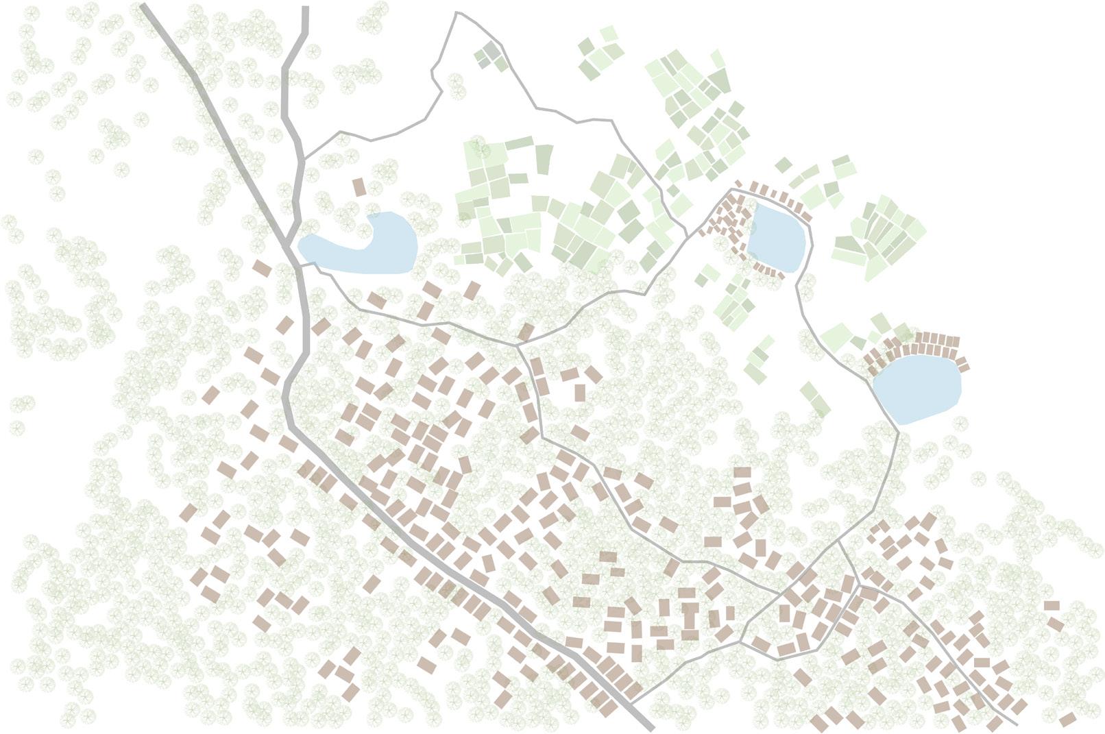
TOPOGRAPHY AND WATER BODIES:
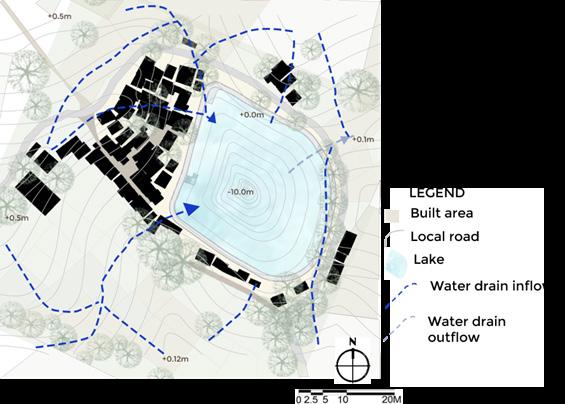
The natural terrain of Vasai is undulating, giving rise to a natural lake system that is networked through several water channels. These water channels carry storm water during the monsoon, feeding the lake. The topographic analysis study of the Saloli area for the development of the Barmale Lake. It includes a de tailed study of contours and slopes and hydrology. The aim is to understand how water drains are formed through the natural topography of the land and understand the inflow and out flow of the lake. All the surrounding wetlands, embankments, open spaces, and culvert work in unison to replicate the land’s natural topography that supports the natural lake system. Bawkhal is a traditional lake and pond found in villages of Vasai. A Bawkhal plays a significant role in maintaining ground water levels in the region. In the past, it was used for irrigation purposes by farmers. The age of this Bawkhal is unknown, but it ranges from 200 years to even a millennium. At the same time, there is no doubt that they played an essential role in supporting agriculture and maintaining groundwater levels in region. However, rapid development and urbanization present a grave threat to these systems. A Bawkhal should ideally sit at a lower elevation, collecting rainwater as it flows downhill. However, the concretization within the bawkhal’s watershed will reroute the water away.
The site has a gentle slope from southwest to east. Due to high groundwater levels and low-level plains, water logging occurs near the Lake during monsoon. The inflow into Barmale originates as runoff – rainwater that falls outside the Lake (but within the basin/watershed). Runoff run down slopes directly into a lake may arrive indirectly, such as by reaching natural or artificial drains that flow into a lake or reaching the Lake under the surface because it soaked into the ground through percolation and became groundwater. In addition to rainfall, runoff, and groundwater, another important source of inflow into our lakes is upstream water releases. At any point in time, Lake’s elevation marks the balance between inflow and outflow. Today, its inflows are negligible, not having recovered from the summer dry despite fall precipitation. Its outflows are reduced but continue, dominated by the ever-present link between the Lake and the aquifer. The lake also receives runoff directly from the slopes and springs adjacent to the lake, and rain and snow that fall on the lake. The average precipitation is 281.4 mm/ yr. The lake outlet opens in the rice field toward the northeast.
Barmale and Uttareshwar lakefront development
Figure 22 Map of Water inlet & Outlet
35
LEGEND


 Mruga Raut Capstone project
Figure Agriculture feilds
Figure Vegetation along road
Figure
Figure of
Mruga Raut Capstone project
Figure Agriculture feilds
Figure Vegetation along road
Figure
Figure of
2022 ANANT NATIONAL UNIVERSITY
Built area Local road Lake Vegetation
23
24
25 Vegetation along lake
26 Map
vegetation
VEGETATION:
Urban vegetation is an essential element of the urban city pedestrian walkway. Despite city forest regulations and urban planning best practices, vegetation planning lacks clear com prehension and compatibility with other urban elements sur rounding it. The site has very high vegetation that supports the ecosystem in the area. The trees are denser near the main road and decrease towards the lake. Maximum trees in Ownership Maximum trees were observed in Private ownership in the site area. Urban vegetation not only directly intercepts and reduces air pollutants (Nowak et al., 2006), but it also increas es the value of nearby homes (Crompton, 2005) and lowers air temperatures (Buyantuyev and Wu, 2010). The vegetation in the Saloli area creates the micro climate in the region, keeping the site cool than the rest of the city. Tree planting in the area is used as a climate-proof residential area. The spread foliage of the trees in the area makes the surrounding shaded and livable.
The southeast lake edge has a high tree density keeping the area shaded throughout the day. The shaded road increases the livability and access to the lake. The dense beneficial veg etation around your lake is extremely important for improving water quality, preventing erosion and controlling. The vegetation zone benefits the surrounding by attracting insects, like dragonflies, that feed on mosquito larvae, thus helping to maintain the mosquito population in and around your lake. It also supports various species of birds kept by the communi ty. The tree also prevents the lake water from the south and west’s harsh heat and protects the community settlement. The children in the area prefer playing around the trees. Their branches are the adult seat in the shade for chit-chatting. The community women use tree shade for their daily activities like cutting firewood and drying clothes and utensils.
 Barmale and Uttareshwar lakefront development
Figure 27 Map of vegetation along lake
Figure 28 View of lake edge
Figure 29 People and vegetation
Barmale and Uttareshwar lakefront development
Figure 27 Map of vegetation along lake
Figure 28 View of lake edge
Figure 29 People and vegetation
37


 Mruga
Mruga
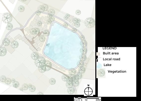
Raut Capstone project 2022 ANANT NATIONAL UNIVERSITY LEGEND Built area Local road Collector road Public transport route Lake BUILT 72% OPEN 28% Figure 30 Chart of Open vs Built Figure 31 Pavement road Figure 32 Lake road Figure 33 Map of Built vs open
CONNECTIVITY AND OPEN VS. BUILT:
In the Saloli area, the pattern of streets and paths (how people move between places) has not evolved over a long period. The urban grain is likely to be finest near the lake where the eco nomically weaker section lives. The grain is coarser away from the lake in the neighborhood, which reflects the less intense demands on movement and agglomeration. Fishing, subsistence agriculture and salt making are the existing economic activities in the area; therefore, the majority of land in the study area is an open area used for agriculture and salt production and plantation. The peripheral status of agricultural laborers, non-Christians and enslaved people in the social space of the region is quite evident.

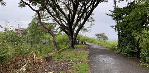
The road connecting the major center of the region, Vasai and Virar railway station, is the central access to the lakes. The lo cal road connects the significant places and the surrounding farmland in the study area. The 3m wide local road area used by the residents living in the area makes road low traffic roads. The road is also used by heavy vehicles like tractors used on farmland.
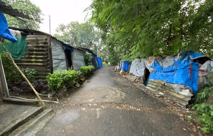
The unplanned streets connect the cluster. Agriculture work ers- the early settlers and Construction workers recent mi grants occupy closely-knit settlements. Kutcha” and “pukka” houses together combine the neighborhoods. The settlements operate like small, self-supporting neighborhood units. The huts are arranged along paths or in clusters that open into shared spaces that quickly adapt to the daily activities of the institution. In the afternoon, men gather to discuss in shade trees, and women gather at the lake to gossip over piles of laundry in the morning. The settlement’s maze-like configura tion offers a sense of security to its inhabitants. Gateways are barely recognizable, and even the youngest children wander freely within the boundaries of their communities.
 Barmale and Uttareshwar lakefront development
Figure 34 Cluster setting
Figure 35 Detail of social space
Figure 36 The connecting spaces
Barmale and Uttareshwar lakefront development
Figure 34 Cluster setting
Figure 35 Detail of social space
Figure 36 The connecting spaces
39
 Mruga Raut Capstone project
Figure 37 Community samaj hall
Figure school)
Mruga Raut Capstone project
Figure 37 Community samaj hall
Figure school)
2022 ANANT NATIONAL UNIVERSITY LEGEND Residential Local road Lake Mix use Commercial Religious
38 Anganwadi( Primary
Figure 39 Convinience shop Figure 40 Map of built use
Figure 41 Map of built use of community
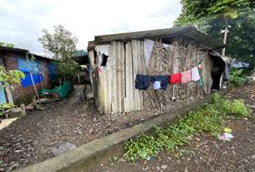
The majority of the houses in the settlement around the lake is more than 70 year which means the area has the ca pability of redeveloping the cluster for better lifestyle and environment for the community living there . The new constructed house are the extended house of the family living in the area. The land is given by the goverment to the community on lease of 99 years. The people are expanding thier boundaries along the the lake edge by constructing teporary shed , backyard and sitting area. This has lead to cluttering of garbage and blocking of inlet .
LEGEND
More than 70 years

Less than 70 years
Local road Lake
Barmale and Uttareshwar lakefront development
The study area, current development consists primarily of a mixture of rural and agricultural uses, including cultivat ed fields, fallow and brush land, woodlands, farm houses and rural residential separations with a number of domes tic business uses. Low dense residential areas with more than 80% built density. Except for the internal roads, the wide primary road (St. Francis road) has commercial and mixed uses on either side, creating traffic and congestion issues. The conversion of residential use to mixed-use and subsequently to commercial nature increases the height of the buildings along roads of narrow widths. Large parcels of agriculture and orchard lands cause inactive zones within the study area. There are adequate parking facilities within the settlements as more than 70% of the house holds own one vehicle (2, 3, or 4 wheeler).
Figure 42 Map of House age
BUILT USE:


 Mruga
Figure
Figure
Figure
Mruga
Figure
Figure
Figure
Raut Capstone project 2022 ANANT NATIONAL UNIVERSITY Local road Lake LEGEND Street light Public toilet Public dustbin
43 Streetlight placement
44 Public toilets Figure 45 Solid waste Management
46 Map of public services
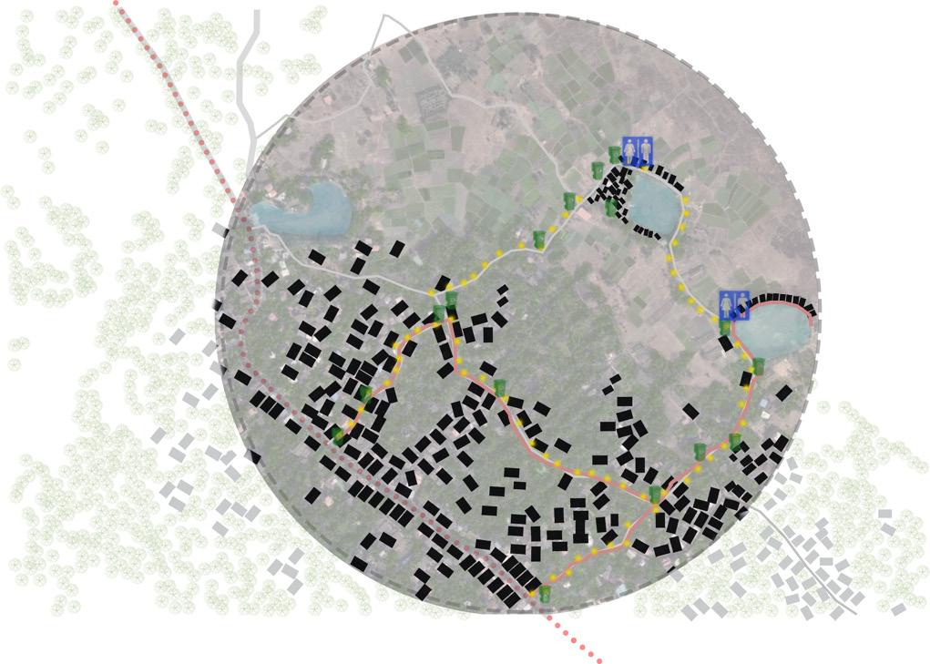
PUBLIC SERVICES AND AMENITIES:
Barmale and Uttareshwar


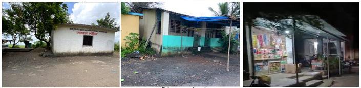
The storm water drains are planned as water drain to the lakes and agricultural open fields. However, the dumping of solid wastes and sewage has resulted in silt formation and the subsequent reduction of its carrying capacity. The solid waste management in the area is done by collecting the waste from the pub lic dustbin placed in the area. The number of dustbins provided in the area is sufficient to carry the waste production. The provision of waste segregation is the issue seen in this area as the municipal co-corporation collected the mixed waste. The street light installation is at 3m to 4m from one other along the road. The entrance of the houses is well lit due to the provision of the street light throughout the area. The public toilets are also provided for the communities living around the lakes. The dustbins in the community are placed in the accessible area from each house. The distance of the street light near the lake edge increases, making the area unsafe during dusk.The survey was carried out of the community living along the lake to analyses the public facilities and services. The community don’t have a facility for drinking. Most of the community de pends on the public tap water for drinking along the primary road; the people travel up to 1km for the water. The community used the water for other purposes from the lakes and bore wells. Some people in the community also used the well water owned by the landlords for drinking. The settlement around the lake used the public toilets more due to insufficient or non-affordable private Toilets. Some houses had government benefits for building or provision of the private washroom attached to the house. The Anganwadi primary government school is attended mainly by the children in the age group 5-10 yrs. of the com munity. It lies in the cluster, making it safe and accessible for the people and kids. The children must move out around 1- 2 km from the community for sec ondary schooling by travelling on foot or by bicycle. The convent and other sec ondary schools are located along the central road and hence can be accessible by public transport.
lakefront development 43
Public toilet 61% Private toilet 39% Public tap 47% Lake and other source 41% Well water 12% Within1/2 km 61% 1km 22% 1 1/2 km 11% 2 km 6% Figure 47 Chart of toilet usage Figure 48 Source of water Figure 49 Primary school
ECONOMY:
The area consists of a mixed-income community, creating a circular econ omy within the neighborhood. The settlement around the lake is an old settlement of economically weaker sections which also has the potential to be redeveloped for better living.
 Mruga Raut Capstone project 2022
ANANT UNIVERSITY
Figure 50 Bunglow typology
Figure 51 Kuttcha houses
Figure 52 Economy map
Mruga Raut Capstone project 2022
ANANT UNIVERSITY
Figure 50 Bunglow typology
Figure 51 Kuttcha houses
Figure 52 Economy map
NATIONAL
L.IG Local road Lake MIG Upper MIG LEGEND
Barmale and Uttareshwar lakefront development
PURPOSE OF THE PROJECT:
Social, Economic & Environmental Impacts: Rejuvenating and conserving a lake requires a detailed understanding of its environmental, economic and social impacts. Several aspects of a lake, in the form of its development over time, change of surrounding land use pattern, watershed area, estimated monetary investments among others must be considered at the time of planning. They can only be understood through a comprehensive socioeconomic and environmental impact study.
1.Lake Rejuvenation: Social Impacts
•Creating spaces for social interaction: rejuvenation of a lake, not only results in improved water storage, but it also involves the development and beautification of lands adjacent to the lake. Thanks to this development, a socially interactive space is created for the neighboring residential community, thus enhancing its social value.
•Creation of a microclimate: Appropriate lake redevelopment leads to the creation of a microclimate in the region. The water present in the lake all year round results in a considerable decrease in temperature in the neighboring region as well as the creation of local winds, which provides a soothing atmosphere.
•Development of Recreational Facilities: Added design elements in the form of jogging and cycling tracks, open gyms, play areas create more value to the space and make it more attractive for the locals. Urban design in and around the lake results in improving the aesthetics and making it more appealing.
2.Lake Rejuvenation: Environmental Impacts
•Improvement of flora and fauna: A body of water attracts several species of birds and causes different species of plants to grow. With a rejuve nating lake, one of the first noticeable effects is the spread of flora and fauna.
•Rain Water Harvesting: In places like Vasai where the summers are harsh and heavy rainfall in monsoon. To counter this problem, during the months of monsoon with high rainfall, the water can be stored within the lake limits and used later. This should be done for all lakes in the region and should be a mandatory practice.
• Control of water quality: As part of the redevelopment, all surrounding wastewater pipes are usually treated to control the flow of wastewater into the lake. The water that enters the lake is a part of runoffs, which further gets purified through the soil on the lake bed, resulting in settling down of silt and better quality
3.Lake Rejuvenation: Economic Impacts
• Better property value: With a rejuvenated lake, the value of neighboring properties increases.
45
04 Site Analysis
Page- 51-68 Rajokri lake, Delhi Periyakulam lake, Coimbatore Kakaria lake, Ahemdabad Bhubaneshwar rewind play, Public spaces in informal settlements, Bhubaneshwar
Mruga Raut Capstone project 2022
RAJOKRI LAKE, DELHI :
Justification:
To study the infrastructure lending to the formation of a sense of harmony in the community by way of creating a ‘Chhath Ghats’. The Active Bio Digester for cleaning the wastewater and effluents released into the water body with the provision of pumps that work on solar energy to pump the relatively clean water into the water body.
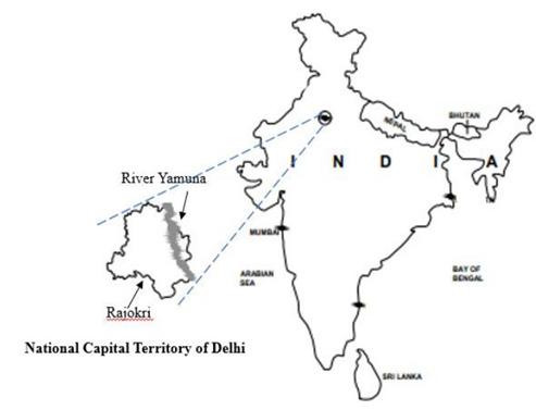
Location: Rajokri Lake (28°30’44.92ʺ N 77°07’10.28ʺ E) is in Rajokri village, near Delhi (India) and covers a little less than 9500 Sq. . The region is in the sub-tropical zone with mild winters alternating with extremely hot summers with average temperatures ranging between 40–45 °C in summers and 4–5 °C in winters. (Agarwal N, Koti SR, Saran S, 2018)
Figure 53 Rajkori lake location
 ANANT NATIONAL UNIVERSITY
Barmale and Uttareshwar lakefront development
Need of project:
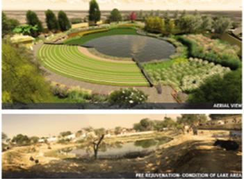
Until 2017, domestic wastewater from the adjoining semi-urban settlements of Rajokri village were channeled through open drains into the lake, which became a breeding ground for communicable diseases.( Ankit Srivastava,2021) .Potential to transformed into a 9,446 Sq. meters of rede veloped public space, with a water body of 2000 sq. which is now fed with treated effluents which, at an earlier date, were the primary pollutants of the water body.
About the project:
The primary objective of the project is to create an eco-friendly ambience in the surroundings of water bodies by creating public space for vari ous recreational facilities for public so as to create a sense of responsibility in the public to behave sensibly in the preservation and conservation of their surroundings particularly around the water bodies. After the success of Rajokri Water Body, the concept of which has been applauded and appreciated by various environmentalists who have visited this site after development, the Delhi govt. is now has working to rejuvenate 250 water bodies and over 15 Lakhs in Delhi to replicate the model of Rajokri to create public participation at large so as to protect the lifeline of the environment, promote ground water recharge and protecting cultural heritage. Further, it has also been ensured that the water level of Delhi be recharged which is depleting day by day after treating the waste water of the water bodies at the inlet point by using SWAB
Key statistics of the water body revitalization project:
• Total area of the water body – 9446 sq.
• Water area – 2000 sq.
• Technology used for revitalization – Scientific wetland system with activated bio-digestion.
• Design capacity – 600 kilo liter per day (KLD).
• Place making through the creation of landscape areas i.e. areas for public gatherings
Expected outcomes:
• decentralized sewage treatment
• groundwater recharge
• rainwater harvesting
• conservation of public place
• reviving cultural place “chatth Puja”
• environmental conservation
49
Design intervention:
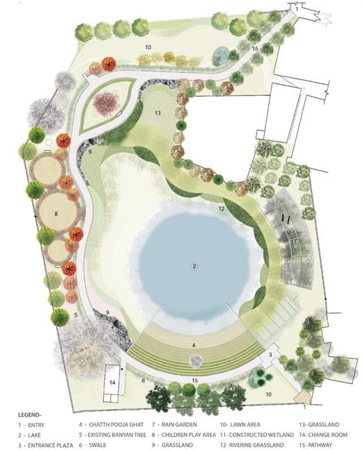
The initial idea was mooted when it was found that people were using the dirty water body for the purpose of ‘Chhath Pooja’. (Chhatt is an ancient Hindu Vedic festival historically native to the Indian subcontinent, more specifically, the Indian States of Bihar, Jharkhand and Uttar Pradesh. The festival is celebrated to thank the Sun God for bestowing the bounties of life on earth and fulfilling particular wishes. (Source – Wikipedia).The Rajokri Water Body revitalization project covers a number of aspects ranging from addressing the provision of infrastructure lending to formation of sustainable communities by way of creating a ‘Chhath Ghat’, open air gyms and play areas for neighborhood children to using the ‘Scientific Wetland System’ with Active Bio Digester for cleaning the waste water and effluents released into the water body along with provision of pumps that work on solar energy in order to pump the relatively clean water into the water body. The introduction of the rainforest and Grassland are designed accordingly to climate and to create diversity in the area. The area is designed as a sponge in the concrete city to percolate water. The project also inclusive of all age group.
 Mruga Raut Capstone project 2022
ANANT NATIONAL UNIVERSITY
Figure Master plan
Mruga Raut Capstone project 2022
ANANT NATIONAL UNIVERSITY
Figure Master plan
54
Barmale and Uttareshwar lakefront development
Recreational space:
The landscape design is according to the topography. The intervention of bio-swales, grassland and seasonal pond to encourage surface water percolation.
The children’s play area is also zoned into different age groups for the child development of the kids living in the area. It also integrates children into the public realm of “child-friendly cities”. The play area has items such landscaping, planting, pathways, fences and gates, seats - everything which goes to makes up an environment. Equipment are appropriate for the each age group and match their developmental needs - as well as being fun to play on. The anthropology of each age group is considered while designing. The open gym and walkways makes the place active during mornings and evening hours.
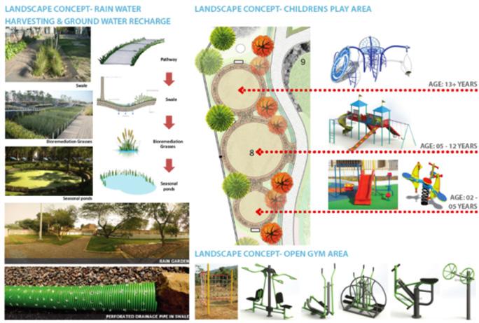
51
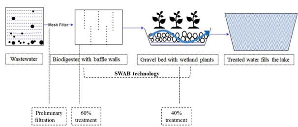
The design capacity of the WWTP is based largely on the flow-through volume – i.e., the amount of water required to fill and maintain the water body throughout the year. Of the total area available, the water spread area - i.e., the area of land covered by water – was determined as about 2000 m2 , using government records and Google Earth Pro. Wastewater from the surrounding areas was channeled through a single inlet and a 0.6 million liters per day (MLD) WWTP was designed.
WWTP Components
The influent wastewater has high biological oxygen demand (BOD) levels. Since limited land was available for the WWTP, a SWAB-based natural system was used. This has two components: a sedimentation tank and a gravel bed.
 Mruga Raut Capstone project 2022
ANANT NATIONAL UNIVERSITY Wastewater treatment plant (WWTP)
Figure 55 Wastewater treatment plant
Figure 56 Baffled wall tank
Figure 57 top viw of WWTP
Mruga Raut Capstone project 2022
ANANT NATIONAL UNIVERSITY Wastewater treatment plant (WWTP)
Figure 55 Wastewater treatment plant
Figure 56 Baffled wall tank
Figure 57 top viw of WWTP
Barmale and Uttareshwar lakefront development
Project benefits:
The revival of Rajokri Lake has had several benefits:
i.ENVIROMENTAL: A revived water body can recharge groundwater effectively. This is critical in countries like India with rapidly falling groundwater levels. The project at Rajokri is immensely helping in improving the falling water table levels in the area. In addition to reviving the lake, bios wales have been created in the area surrounding the lake with percolation pores for water retention, groundwater recharge and also regulating the flow of rainwater into the lake. These bios wale systems function as an alternative to storm sewers and remove pollution and debris from rainwater and divert it to the lake. .(Roshankar,2020) Delhi comprises just 2% of the catchment area of the Yamuna River, but is the source of 80% of the pollution flowing into it. An investment of $54 million has been made towards a comprehensive action plan to intercept and treat sewage.
ii.SOCIAL: Water body revival increases human contact, so water quality should be maintained at the highest level. Water bodies serve as sociocultural sites worldwide and their revival can help to rejuvenate socio-cultural practices. The revived Rajokri Lake serves as a community space for religious and other activities, with an amphitheater, open gym and walking space (Consortium for DEWATS Dissemination Society,2019). In addition, the project ticks the boxes of biodiversity enhancement through plantation of native tree species in the premises of the lake. Prior to the project, the lake was a sewage sink and a source of communicable diseases. With no stagnant raw sewage present, the threat of mosquito breeding has been eliminated. The Lake No longer has an unbearable stench and at least 15 species of birds have returned to the locality. The decentralized treatment system provides aesthetics with the treatment of wastewater occurring below ground. The government of Delhi is making water distribution systems more transparent, efficient, and accessible by expanding infrastructure to reach communities, including those that are unauthorized. By providing equitable access to water, the city is ousting the water mafia and creating happier neighborhoods.
iii.INHIBITING: flooding Water bodies can play an important role in urban flood management (Bindu CA, Mohamed AR ,2016). Proper revival strategy planning can ensure that excess water, e.g., from local roads, finds its way into the water body and is not lost. Chennai was badly affected by floods in 2015 and suffered extensive damage (Joerin J, Steinberger F, Krishnamurthy RR, et al. ,2018). A major reason for the severity of the damage in Chennai was that floodwaters could not find their way into water bodies so the roads were flooded. This can be attributed largely to poor urban planning and management. Landscaping at Rajokri has been designed in such a way to prevent flooding. Rain gardens on two ends of the lake ensure that water drains into the lake. Now that it has been revived, Rajokri Lake can play an important role in inhibiting flooding in the Delhi region.
iv.COST BENIFIT: The project is sustainable, and has negligible operating and maintenance costs. The wastewater treatment system is basically natural and refills the dry lake. Moreover, the cost of treatment of wastewater is less than 0.014 USD/KL which is cheaper than the conventional treatment of wastewater. The Rajokri model includes space for socio-religious activities and therefore involves community participation in safeguarding the revived water body. .(Roshankar,2020)
53
Mruga Raut Capstone project 2022
PERIYAKULAM LAKE, COIMBATORE
Justification:
To study the restoration of lake and enhancing bio-diversity. Street furniture and the spaces intervention in the project .
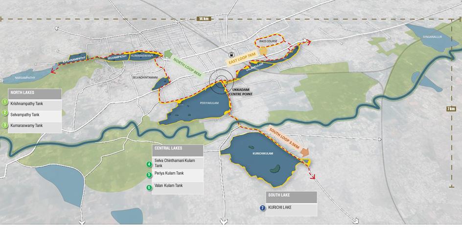
Location: Ukkadam Periyakulam Lake, also known as Ukkadam Big Tank (10°580 540 N 76°570 170 E), has a wide spread area over 1.295 km2 (0.500 sq. mi), average depth of 5.82 m (19.1 ft), and is situated in Coimbatore City, Tamil Nadu, India. Located near the main bus terminal of Ukkadam and is quite accessible by foot from the main bus junction. On the other end it is nuzzled right across the famous Ukkadam market tucked away on the road leading to the Perur junction. It is 5.8kms from Gandhipuram and less than a mile away from Coimbatore’s Railway station. (oasis)
ANANT NATIONAL UNIVERSITY
Figure 58 Location map of Ukkadam Periyakulam Lake
Barmale and Uttareshwar lakefront development
Need of project:
The lake is one of the urban wetlands of the city, home of residential and migratory birds. The local fishermen depend on the lake for their living.
Before 2019 the lake is use for is a huge trash can, toilet and a dumping site. The lake was desilted, before the year with huge efforts by NGOs RAAC, Siruthuli, defense personnel and the people of Coimbatore. But the lake is still not rescued from garbage dumping. “All those efforts will be in vain, if we don’t stop the dumping. Now the water hyacinth (aagaya thamarai) is starting to spread. Something should be done” – says another resident near the lake. (smart city of Coimbatore)
About the project:
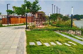
City under the smart cities mission. In the first phase of the project, the corporation will be redeveloping the Periyakulam Lake, vallinkulam lake, & areas beneath the vallinkulam bridge at a cost of 88 cores. The lake development project has been designed by oasis resource management & construction works have begun at these lakes. (Smart city of Coimbatore)
Site Potential:
Periyakulam is located at the focal point of the city connecting the northern and southern sides, Due to its scale, it also has the capacity to be a city level destination as well as tourist destination. The northern edge of Periyakulam (Quickwin) is bound by Perur By-pass road-an important road in the city and connects to the Perur main road ultimately connecting to Perur. Thus, it can have a City level impact. The northern edge is a walkway bund and hence the bund height can be lowered allowing for better visual access and also create active promenades long the lake front. Different nodes as per different contexts have been defined along the edge and these act as city level nodes as well. (smart city of Coimbatore)
Project Aim:
To create cross - sectoral solution to create a unique opportunity for the city to re-align itself to protect, conserve and celebrate its cultural heritage and help tackle problems of sewage pollution.
Project key consideration:
• A sewage treatment plant is also set to be established there, along with
• A walking path, bicycle track,
• children’s park,
• open gyms
• musical fountains
• Landscape.
55
Design intervention:
The lake is also be revived with park, open public spaces and botanical garden which pose as an added attraction. The water quality of the lake will be monitored continuously with proper mounted floats with WIFI connectivity. Apart from that, protected exclusive paths will be constructed for the purpose of walking and jogging and cycling with sky walks over roads will also be developed. Pertinently developed sewage plants will be set to have an eye on all the natural trains carrying sewage public transport thereby creating smart traffic and bye-bye congestion across the Coimbatore city. Complex functions will have facilities like proper seating arrangements, footpath, cycle lane footpath, lighting, bus bay, passengers shed, drinking water, sign symbol, bike parking and ramp for the disabled. (SC,Coimbatore)
 Mruga Raut Capstone project 2022
ANANT NATIONAL UNIVERSITY
Figure 59 Design proposal
Figure 60 Design proposal view
Figure 61 Sitting area
Figure 62 Accessibilty to lake
Figure 63 Lake view
Mruga Raut Capstone project 2022
ANANT NATIONAL UNIVERSITY
Figure 59 Design proposal
Figure 60 Design proposal view
Figure 61 Sitting area
Figure 62 Accessibilty to lake
Figure 63 Lake view
Barmale and Uttareshwar lakefront development
Outcome of the project:
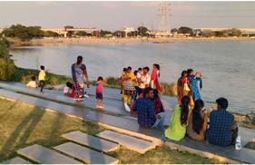
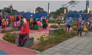
The 550-acre water body served as a direct source for irrigation and an indirect source by ensuring recharge of groundwater table, so that cultivation of various crops could be taken up by farmers in about 5,000 acres in the region. The project also connected the lake to the city and the people. It also established the visual and physical link between the lake and the surrounding. The project created a vibrant, open space public space in the city. The ecological restoration of the lake. It also help in restoring ground water in the area. These bios wale systems function as an alternative to storm sewers and remove pollution and debris from rainwater and divert it to the lake. The people in the city and NGO’s also encourage to conserve the water body. The place is inclusive and supports all the age group. The use of technology also help in monitoring the lake and the water bodies which helps in monitoring the water management in the city.
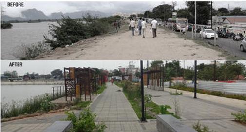
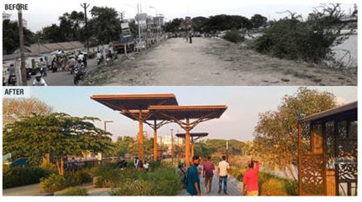
Figure 64 Before vs After
Figure 65 Before vs After
57
Mruga Raut Capstone project 2022
Justification:
To study the distribution of activities and spaces along the lake edge with context to the site surrounding and creating a recreational node in the city.
Location: Kankaria Lake is the second largest lake in Ahmedabad, Gujarat, India. It is located in the south-eastern part of the city, in the Maninagar area.
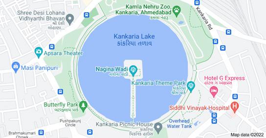
Figure 66 Location map of Kakaria lake
About the lake:
The construction of the lake started by sultan muizz-ud-din muhammad shah II in the 15th century. The inscription at the lake mentions that it was completed during the reign of sultan qutb-ud-din ahmad shah II in 1451. According to this inscription, its name is placed as “hauj-e-qutb” (pond of qutb) after him. The Kankaria Lake has been an inseparable part of the identity of Ahmedabad since its foundation in 1451. Kankaria tank was included in municipal limit in 1884 A.D .In 1928, Kankaria Preservation Act. Was declared protected under the Ancient Monuments. (HCP)
ANANT NATIONAL UNIVERSITY KAKARIA LAKE, AHEMDABAD
Barmale and Uttareshwar lakefront development
Need of the project of Project:
The heavy traffic on the lake side road, disorganized informal activities, haphazard use of the right of way and the lack of sufficient access to the lakefront prevented the complete utilization of all its potentials. Initiated by the Ahmedabad municipal corporation, this project is a comprehensive lakefront precinct set in the heart of the city of Ahmedabad, and conceived as a memorable recreational urban space. Its primary objective is to create an efficient and durable infrastructure which would foster entirely new activities in addition to supporting current ones. (HCP)
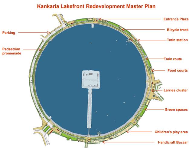
Purpose of the project:
Redevelop the dying center of the city, as a clean, managed and an organized one. Educating and relocating the vendors became an important part of process trying part of the process Inclusive for all - public city Center’ and creating boundary Wall the paradoxes existing in this place.
• Create a ‘lake front recreational area
• Formulate a strategy for such development
• Pedestrianize the lake front
• Explore idea of running a small
• Train along the lakefront
• Develop streets connected to the lake front
• Create development opportunities in the surrounding areas “identify underutilized land (rail yards, etc.) and integrate with new, development
• Improve the area around the lake
Project consideration:
Boating, Museum, Aquarium, Water walk, Butterfly park, Exhibition, safari, Balloon safari, Food courts, Kids play zone, Zoo park, Toy train Desert, amusement park, kids city, toy train, ballon safari, nagina wadi, stone mural park, ambubhai purani vyamshala. Festivals And Other Events At Kankaria Lake
January – dog show by Ahmedabad police. September – ras garbha December – kankaria carnival
59
Zoning:
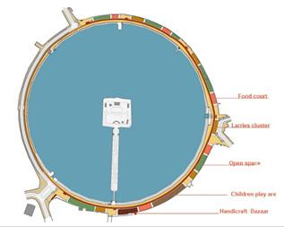
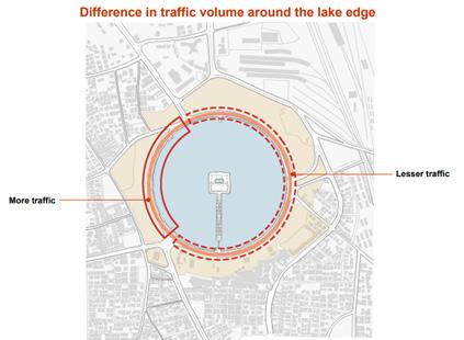
The analysis of the traffic around the lake and identifying the characteristics of the lake edges. The accessibility initial consider for the zoning of the area.

After identification of pedestrian area from the existing condition of the lake. The area was fully pedestrianize to activate the social, leisure life of the people .The area for recreation was demarcated. The allocation of different spaces for the activities to purpose was designed according to the surrounding. The provision of food court, handicraft bazaar and play area gave the user a mix experience. The open space supported the biodiversity in the area and create buffer between the activities. The junction of the lake edge were carefully designed as the entrance and exist to the space . The circulation around the lake make the space more livable and active.
 Mruga Raut Capstone project 2022
ANANT NATIONAL UNIVERSITY
Figure 67 Traffic analysis Figure 67 Zoning
Figure 67 Activity zoning
Mruga Raut Capstone project 2022
ANANT NATIONAL UNIVERSITY
Figure 67 Traffic analysis Figure 67 Zoning
Figure 67 Activity zoning
Barmale and Uttareshwar lakefront development
DESIGN INTERVENTION : Cultures That Existed At Kankariya And Are Enhanced/Controlled By The Lake Front Development Project –
(i) Culture of celebration
Noting down events that take place at Kankaria like dushhehra & eid celebrations etc.. Now events like Kankaria carnival, navratri and other such events make Kankariya as one of the most important cultural centers of the city.
(ii) Culture of food
Food is generally inherent part of Indian culture.
A public place like Kankaria is no different when it comes to food. It would have started as a need, but definitely developed as a culture that is practiced by many, i.e. enjoying food at the lake.
Cultures That Are Newly Added To Kankariya Lakefront Project –
(i)Culture of walkability (pedestrian friendly public space):A complete pedestrian friendly space is difficult to achieve and implement in the current urbanized context of Indian cities. This project made a successful attempt Towards a complete pedestrian friendly public space.
(ii)Culture of public art: From wall paintings to stone murals, art has become an inherent culture of this place. Various events that promote this culture also are the living examples of the same.
(iii)Culture of recreation and gameS: Various games for kids like bungee jumping, water riders train ride etc. Has brought in the culture of involving kids in outdoor activities, also allowing kids to interact with various murals showing Gujarat’s development in a public place like this.
Figure 68 Master plan
61
Justification :
To study the use of space and the materials used in innovative way.
About the project:
• Site area: Multiple Sites (0.2 Acres +)
• Client: Bhubaneswar Development Authority
• Consultants: Bhubaneswar Urban Knowledge Centre and Anthill Creations
Aim of the project : Bhubaneswar is one of the first cities in India to establish a Smart City Center for children. As part of this journey, one of the main learnings was the importance of public spaces for promoting early childhood development through design and programming. To ensure that underprivileged children don’t miss out on play, the city administration converted a few neglected sites into colorful playgrounds. The Rewind Play project aimed to provide varied play and recreation opportunities for all children in Bhubaneswar, especially those living in areas where access to playgrounds is limited or non-existent. .( Transforming urban landscape in india, niua , 2022)
Project Overview:
Due to lack of data on vacant public spaces, an extensive city-wide survey was undertaken by Bhubaneswar Urban Knowledge Centre (BUKC) to scout for relevant spaces which could be developed as playgrounds. Local government was unable to fund the project due to material constraints in the tariff schedule and the innovative and state-of-the-art nature of the project’s progress. The design of play materials for children’s early childhood development has been undertaken by experts. Residents and other stakeholders have been provided with the authority to manage and maintain the public space.( transforming urban landscape in india, niua , 2022)
Mruga Raut Capstone project 2022
ANANT NATIONAL UNIVERSITY
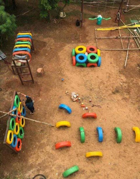
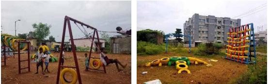
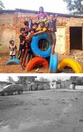
BHUBANESHWAR REWIND PLAY, BHUBANESHWAR
Figure 69 Arial view of play ground
Barmale and Uttareshwar lakefront development
Project Details:
The project has redesigned used tires on cars, trucks and tractors to create innovative and low-cost playgrounds. The goal was to give children enough opportunities for outdoor activities in an era of rapid urbanization and reduced open spaces. .( Transforming urban landscape in india, niua , 2022)
Process:
To provide formal play spaces in a faster and cheaper manner, the method of tactical urban planning was adopted. The approach was to form successful collaboration with experts and organizations in the form of knowledge sharing and professional partnerships to introduce world-class best practices. For each phase, stakeholders were involved in gathering and sharing information, practical implementation, painting and knowledge sharing. .( Transforming urban landscape in india, niua , 2022)
Highlights:
Rewind Play was a successful collaboration between urban knowledge and technical expertise to transform underutilized spaces into play spaces giving every child a chance to have a joyful childhood. This unique take on developing play spaces that instil the habit of recycling and gives a sense of ownership through co-creation was successful in seeking funding support from Odisha Mining Corporation (OMC) and administrative support from Bhubaneswar Development Authority (BDA) and Bhubaneswar Municipal Corporation (BMC).
Challenges:
To identify the need for formal play spaces for kids, the BUKC started scouting for localities where kids were not getting enough play opportunities and were forced to play in an unsafe manner. Spaces identified included several informal communities, government schools, neighborhood open spaces, and underutilized vacant land parcels
Outcomes:
Tactical Urbanism is an efficient tool to convert an underutilized piece of land into a thriving public space, at the same time allowing active participation of stakeholders to ensure an increased sense of ownership and belonging. Collaboration with locals and other professionals is important and innovation in the sources of funding is important and part of its CSR program.
Figure 70 Before vs. After
Figure 71Playground view
63
Mruga Raut Capstone project 2022
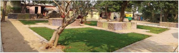
PUBLIC SPACES IN INFORMAL SETTLEMENTS, BHUBANESHWAR
Justification:
To study the design of universally accessible community spaces and connecting the community with the surrounding.
About the project:
• Status: Completed in January, 2021
• Site Area: Multiple Sites (0.70 Acres +)
• Location: Bhubaneswar, Odisha
• Client: Bhubaneswar Municipal Corporation (BMC)
• Consultants: Bhubaneswar Urban Knowledge Centre (PgMC managed by IBI Group India), Bhubaneswar Municipal Corporation
Project aim:
The key aim was to develop universally accessible community spaces within informal settlements of Bhubaneswar, by improving the existing infrastructure, ensure that they are child-friendly and create works of art and utilitarian installations that reflect their culture and enhance their quality of life.( transforming urban landscape in india, niua , 2022)
Project Overview:
Public spaces designed and developed with the local community (especially if it is an informal settlement) evolve as the best social interactive spaces as opposed to public spaces designed as per the whims of designers. The design of these public spaces is based on the adaptation of tactical tools for implementation in order to obtain results more quickly. .( Transforming urban landscape in india, niua , 2022)
Project Details:
The city’s municipal procured the materials necessary for the project locally, and residents were involved in the implementation process. Once public areas have been developing the social media team from the Bhubaneswar Urban Knowledge Centre (BUKC) shared the process and its outcome with the city to initiate a dialogue between the residents and the local authorities.
ANANT NATIONAL UNIVERSITY
Barmale and Uttareshwar lakefront development
Project Details:
The city’s municipal procured the materials necessary for the project locally, and residents were involved in the implementation process. Once public areas have been developing the social media team from the Bhubaneswar Urban Knowledge Centre (BUKC) shared the process and its outcome with the city to initiate a dialogue between the residents and the local authorities.
Highlights:
The inhabitants of the community, especially children, were one, enthusiastic with regard to the possible development of public spaces within their area. The whole process was participatory in nature, resulting in an increased sense of responsibility and pride among those who resided there.
Challenges:
There was insufficient data to identify vacant spaces in institutions that could be accommodated as public spaces. In addition, there was no documentation on the social, demographic, cultural and other aspects of the region. Local people and residents did not know about the public spaces, their importance and the basic infrastructure needed to ensure universal accessibility and the diversity of recreational opportunities. Inter-agency coordination and communication had an adverse effect on the project schedule The fee structure and limited availability of funds meant that there was little room for innovation in the design of public spaces. This reduces the life expectancy of interventions. .( Transforming urban landscape in india, niua , 2022)
Outcomes:
Public spaces irrelevant to any socio-economic background demand only five things - easily accessible by all, protected from high-speed vehicles (safe), well-lit and easily recognizable (legible), clean and shaded seating spaces and being rewarded with revisit propensity. The government does not need huge amounts of money to create or strengthen public spaces. Informal settlements flourish in such spaces and require dynamic/
Figure 72 Design intervention of community space
65
05 Project proposal
Page- 71-90
Design Basis: Potential spaces
Design evolution
Master plan
Sectional view
Design details
Project phasing
Project management
Mruga Raut Capstone project 2022
Design Basis: Potential spaces
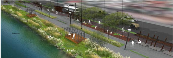
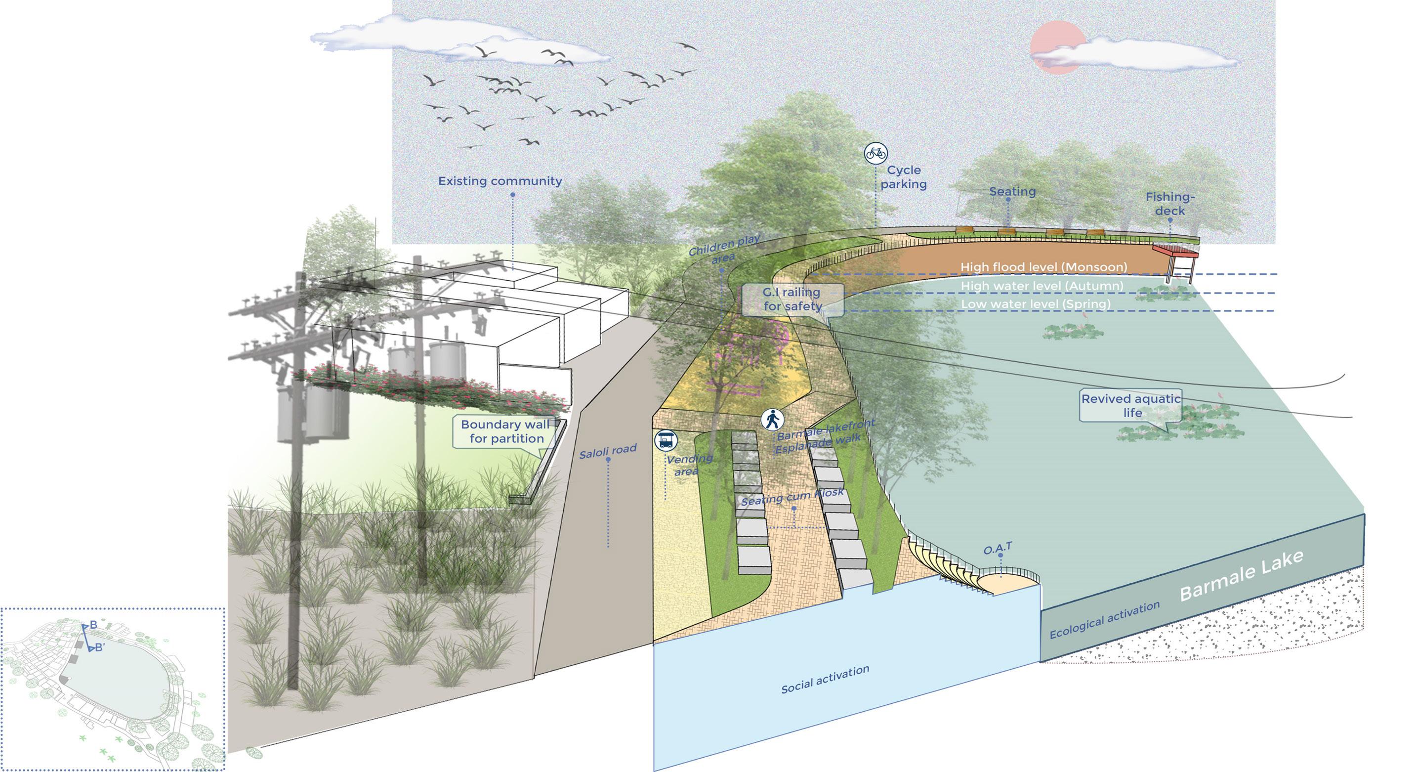
The site is approached through local roads in the south and north, while a secondary road is present towards the west. The areas with high potential for integration with the concept design include the existing agricultural fields, the primary school in the vicinity, and the residential community around the lake. The concept design proposes a social no to give visitors an experience of arrival and provides defined access between the existing community and the lakefront. The development will include adding public facilities for an enhanced visitor experience. The proposed recreational space is designed to enhance accessibility to the lake and to provide public utilities like toilet blocks, cycle parking, and vending area.
Design evolution:
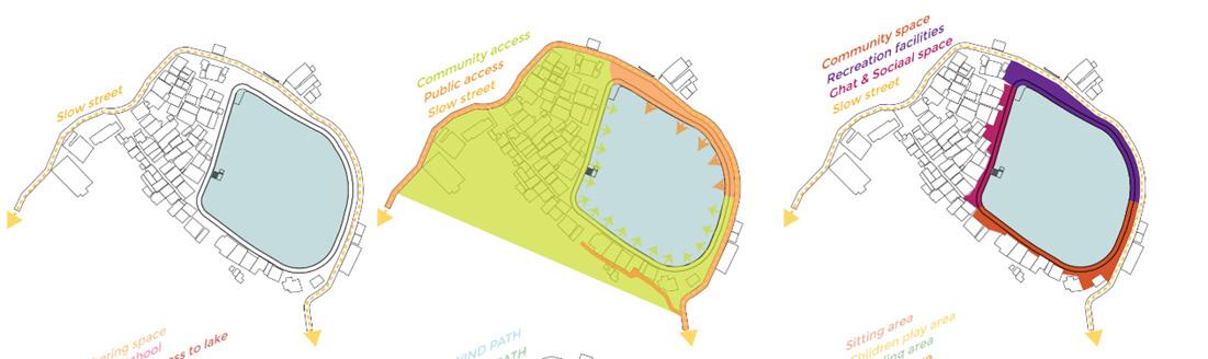
The identification of the street was first studied, and the slow street added potential to design the area as a recreational zone. The street invited people from outside the city to the lake, which was in desperate need of morning and evening walks. An outsider accesses the lake from the local road on the western edge. The community settled on the north and western parts of the lake and connected to the lake through the steps provided on the northern lake edge. The zoning of different activities like community space, recreational facilities, Ghats, and social space is designed according to the accessibility of stakeholders around the lake and the connection of the people to the lake.
ANANT NATIONAL UNIVERSITY
Barmale and Uttareshwar lakefront development
Design evolution:
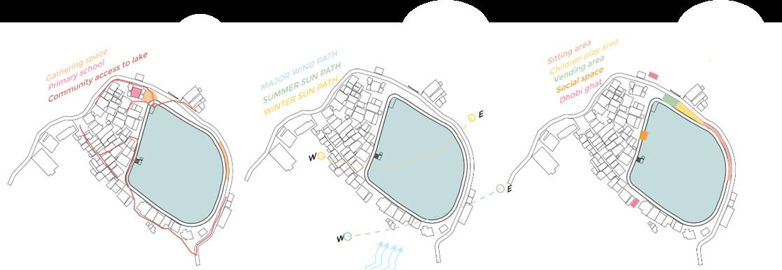
After zoning the major activities area study of community and the routes to reach the lake was identified , the existing social gathering spaces on the site and placement the primary school. To know the behavioural pattern of the community all the people living in the area. These special activities like the Dhobi Ghat please keep area work place near to the most accessible point for the community and the children’s of the community around the lake edge. The people Outside the community usually come here for evening and morning walk therefore the people also loves to enjoy the view of the lake and the surrounding. The Further study of sun and wind helped in placement of the seating around the lake in which the people would enjoy the morning sun rays and would be protected from the afternoon high sun heat. The wind flow from the South west or north east was considered while orienting the seating arrangement. The further placed audit was done and the activities on to be proposed will mark on the site according to the community pattern the sun path and the accessibility of the people living around the lake.
Sitting area
Vending area
children play area
Dhobi Ghat
69
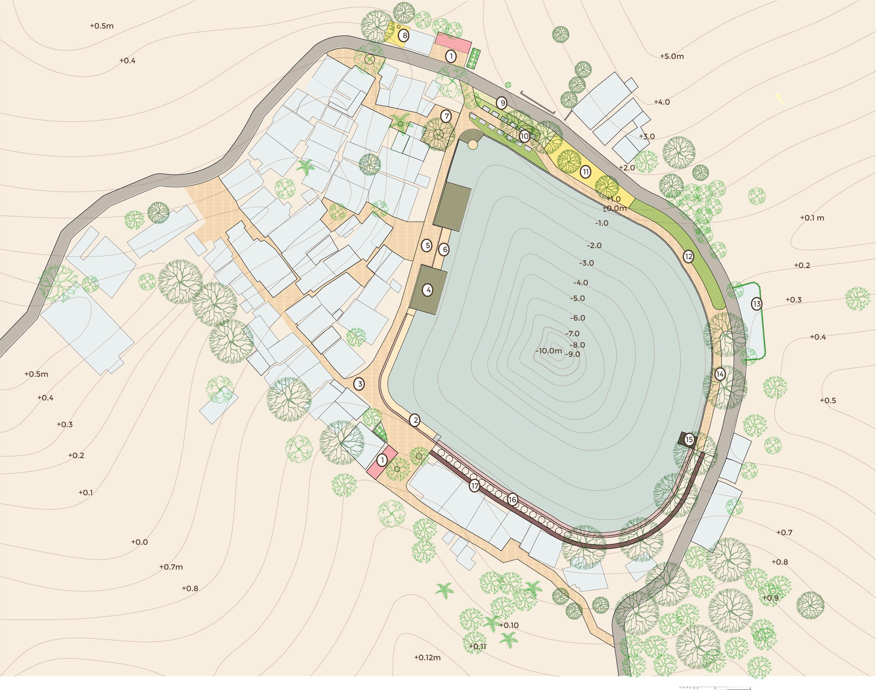
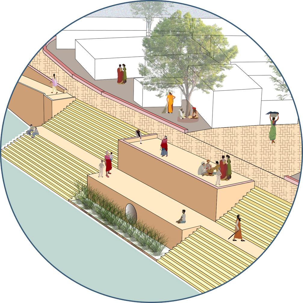
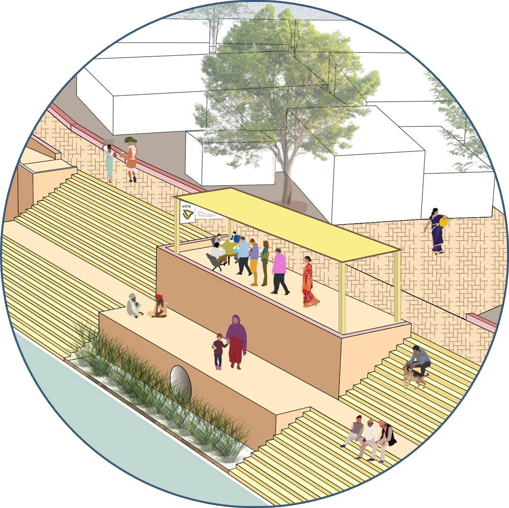
Mruga Raut Capstone project 2022 ANANT NATIONAL UNIVERSITY LEGEND 1. DWWT 2. RAMP 3. PATHWAY 4. GHAT 5. GATHERING SPACE 6. SEATING 7. E-TOILET 8. CULTURAL SPACE 9.VENDING 10. SITTING CUM KIOSK 11. PLAY AREA 12. SEATING 13. CYCLE PARKING 14.WALKWAY 15. DECK 16. COMMUNITY DRY AREA 17 . PATHWAY
Barmale and Uttareshwar lakefront development
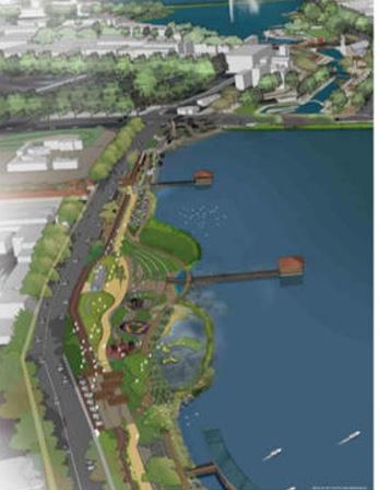
MASTER PLAN :
Master plan:
The Masterplan will focus on the following main points:
• improving the condition of the main & secondary vehicular approach road
• introduction of urban plaza with utility block that houses public facilities (toilets, drinking water) at the entrance in the eastern side of lake
• another urban plaza in the south of the lakefront that can be another place for visitors to pause their journey along the perimeter and look out towards the lake
• creation of a ghats to connect with the lake
• kiosk that provides food and beverage options
• continuous pedestrian plaza along the perimeter of the lake
Key Design Features
Following are the major design features of Project
• Walking and jogging track – Total length 600 meter
• Public Plaza with varying width – Total length 200 meter
• Cantilever projected 5-meter-wide viewing deck.
• Screen barrier & silt trap at inlet.
• Enhancement of existing steps.
• Seating & recreational area.
• Male & Female toilet blocks.
• Railing provide to define lake periphery and access.
• Pavement to comment the lake and the settlement
• Vending area
• Children play area
71
 Mruga Raut Capstone
project 2022
Barmale and Uttareshwar lakefront development
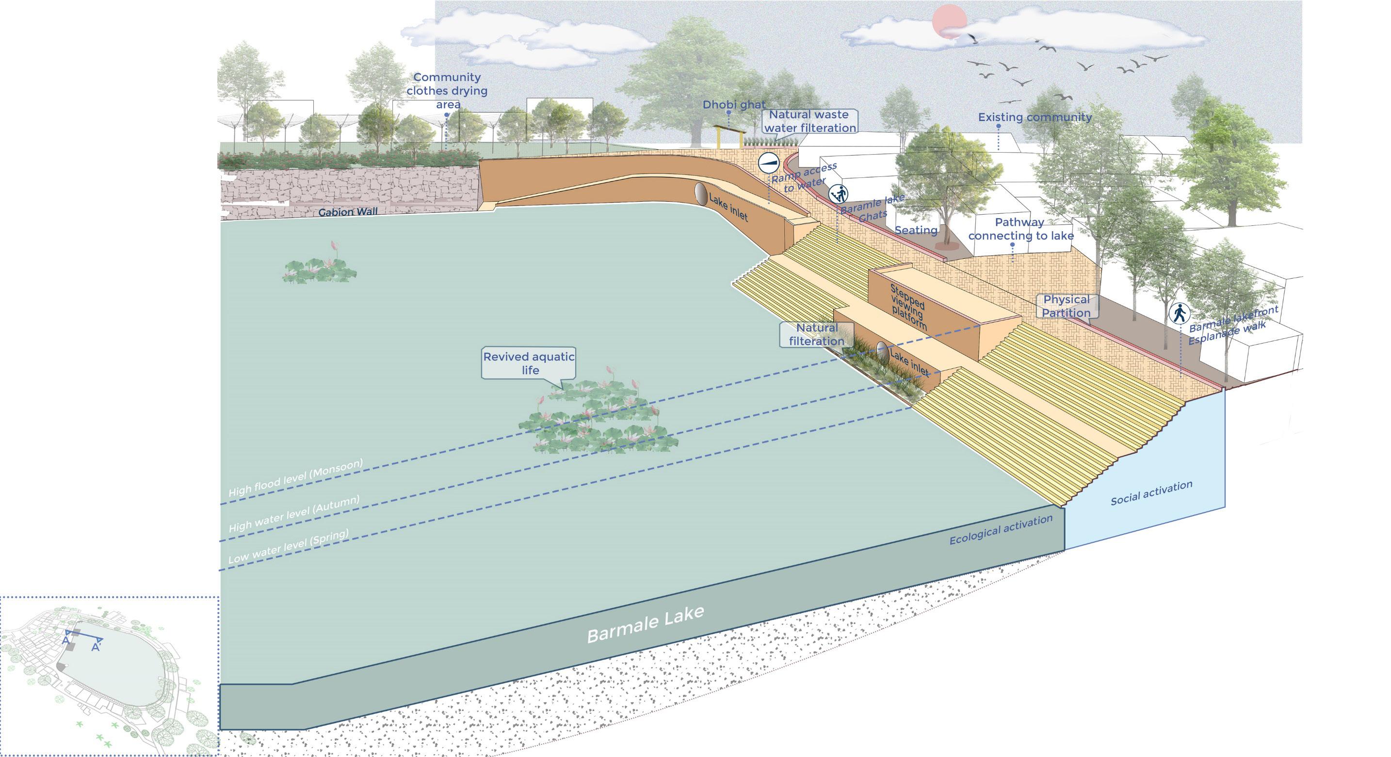
SECTIONAL VIEW :
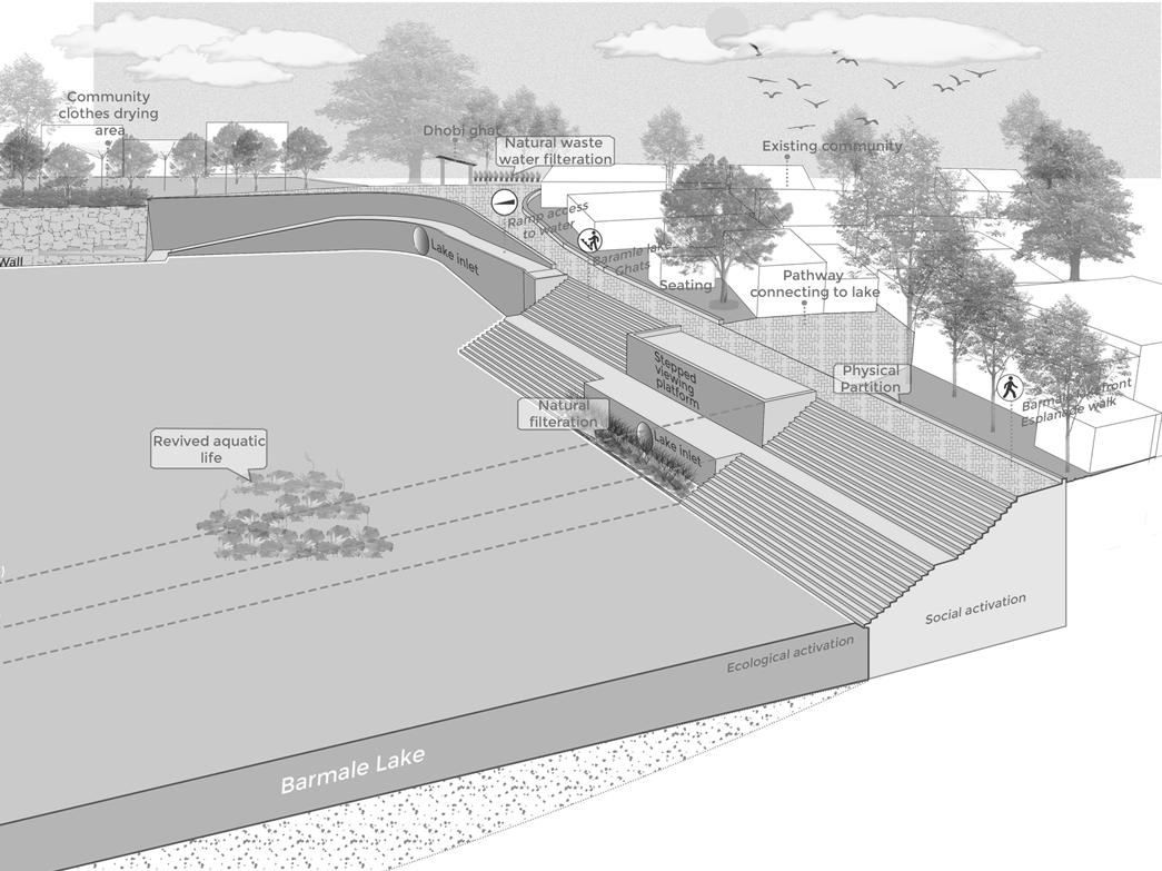
To avoid the direct use of lake water which pollutes the water and reduce the quality of water in the lake the Dhobi Ghat has been built for the community to carry out their daily activities like washing clothes and utensils the water for washing the clothes and utensils is taken from the borewell and stored into a water tank later the waste water is transported to dip to settlers. the Settler one The oil – the top are situated at the topmost part of the water and the below water is later trance meted into the second cycle or the second Settler settles the organic waste of particles and the upper water is further taken forSecondary treatment to anaerobic treatment in baffled rectors. After the secondary treatment the final and the third is the treatment of polishing the waters is released in the lake. The benefit of proposing this water sensitive design would help to restore water in the lake and prevent the depletion of water. Due to the continuous water in the lake would also help in recharging the groundwater which can be again use by the people therefore this is what is it creates a water cycle in this site.
Due to compact cluster settlements the community don’t have an open space to dry their clothes therefore they use the edge of the lake to drive the clothes. And community area for drying clothes were provided to improve the aesthetics of lake and also have a space for a community to carry out their activities. The community clothes drying area is near to the Dhobi Ghat where the people would carry out their washing activities. The provision of top spinner rotate touring dryer would give maximum space and an individual drying area for each house in the community or can use alternate days delivery by each house. The The green plantation in front of these top spinner would cover this space and gave a private area to the community and would also act as a screening between the community and the public public area.A pathway which connects the hous es and the dry area is accessible joining the all the houses and the Dhobi Ghat.
73
DESIGN DETAIL:

 Mruga
Mruga
Raut Capstone project 2022 ANANT NATIONAL UNIVERSITY
DESIGN DETAIL:

Barmale and Uttareshwar lakefront development 75
 Mruga
Mruga
Raut Capstone project 2022 ANANT NATIONAL UNIVERSITY
Barmale and Uttareshwar lakefront development
SECTIONAL VIEW :
The kiosk and seating is the area that characters demographic of all the ages that they can use the space. The space in design according to the activity that is carried out in the lake reaching by different stakeholders. It can be used as a resting or seating point for the morning walkers, jog gers all the people of the community and outsiders to enjoy the morning view of the lake and the sun rise from the east. The place can be also used for general community meetings or gatherings peas in late morning. The children of the community living along the lake has a creative mind which can be encouraged By designing a space for children which would give them a ETA to create their designs. The children use road surfaces or the lack age for creating designs from the chalk and small leaves of the tree providing such platform would give them a particular space where they would interact and design together. This place and the surrounding would also encourage the children to engage in two tree plantation or agricultural activities.The afternoon hours the place can be used by the children as a play area or learn place cave in the shade of the trees since the area is visible from these from the road and the school There is more eyes on the street which creates a safety for the children. India early evening the space can be again use for this sitting by the people and can be slowly transit into a kiosk area which would complement the vending area along eight the kiosk area provides an opportunity for the community to to sell their products Daily to the outside people this would also become an transition note that connects the community with the outside world. The restriction of lesser area and more activity can be easily managed by providing such flexible spaces in the public area.
A main lesson learned from the site analysis was the importance of public spaces in promoting early childhood development through design and programming. To ensure that underprivileged children do not fail to play, the proposal is to convert some lake edges into colorful playgrounds near the school which can be accessible for all . The project aimed to provide a variety of play and recreation opportunities for all children in Saloli, particularly those living in areas near to lakes no access to playgrounds. As part of the project, the used tires of cars, trucks and tractors have been revamped for fun and colorful gaming equipment to create innovative and inexpensive playing fields. The objective was to provide children with adequate opportunities for outdoor activities in an era of rapid urbanization and reduction of open spaces. To provide formal play spaces in a more rapid and cost-effective manner, the method of tactical urbanism is adopted.
77
DESIGN DETAIL:
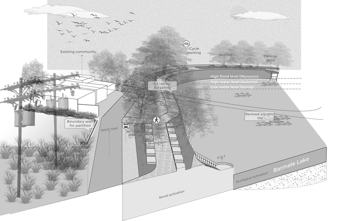
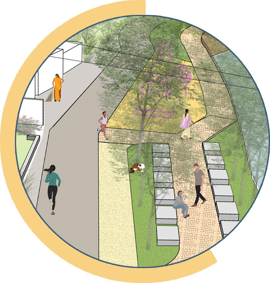 Mruga
Mruga
Raut Capstone project 2022 ANANT NATIONAL UNIVERSITY
DESIGN DETAIL:
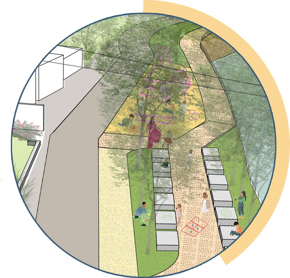
Barmale and Uttareshwar lakefront development 79
DESIGN DETAIL:

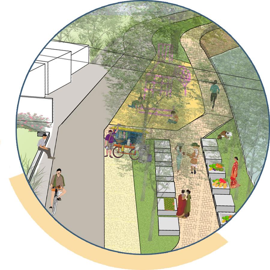 Mruga
Mruga
Raut Capstone project 2022 ANANT NATIONAL UNIVERSITY
DESIGN DETAIL:
Block dimension
Adult anthropology for sitting
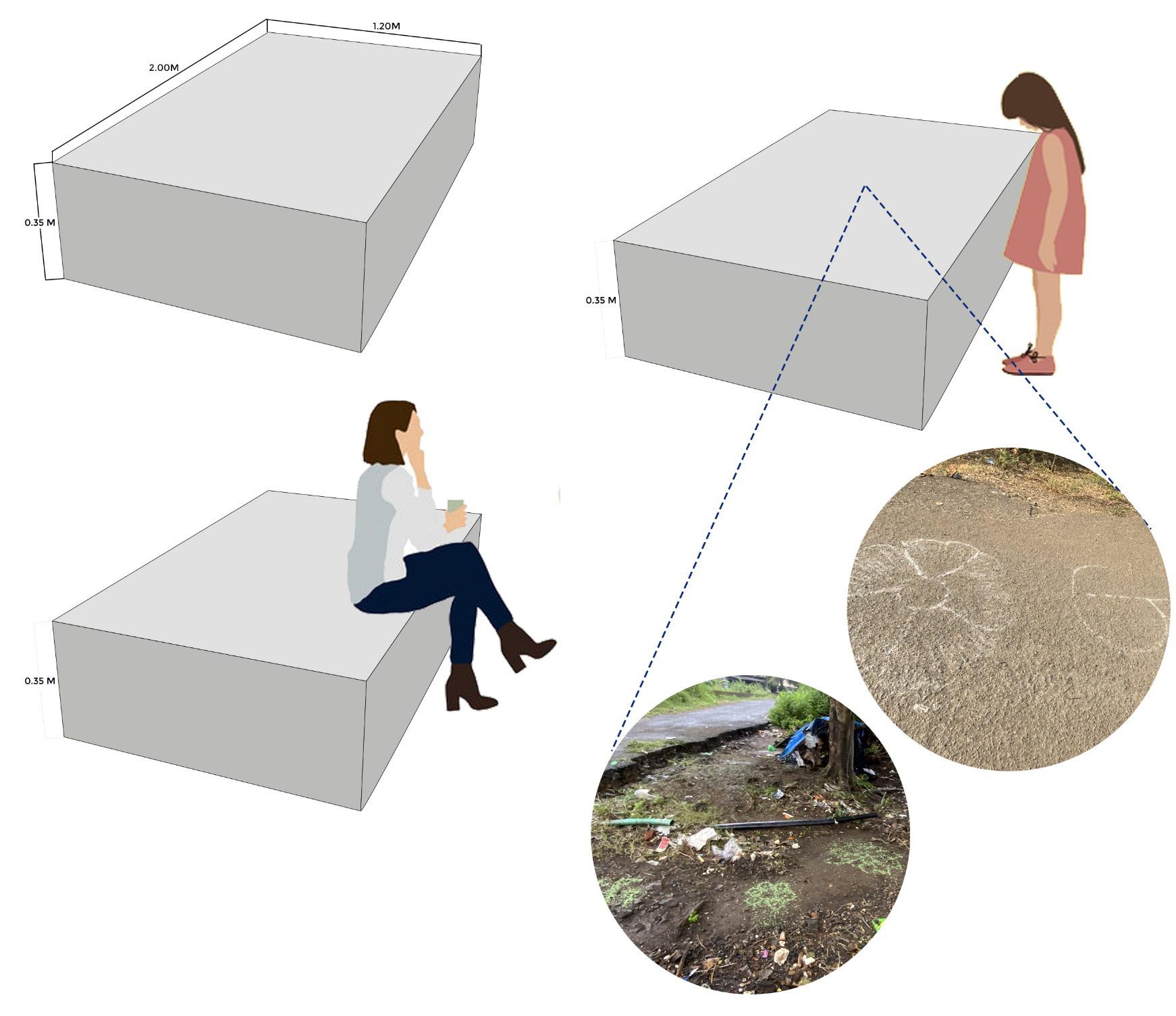
Block dimension
Barmale and Uttareshwar lakefront development
Child anthopology (5-10 year) for using as activity platform
81
Mruga Raut Capstone project 2022
DESIGN DETAIL: E- mobile toilets
ANANT NATIONAL UNIVERSITY
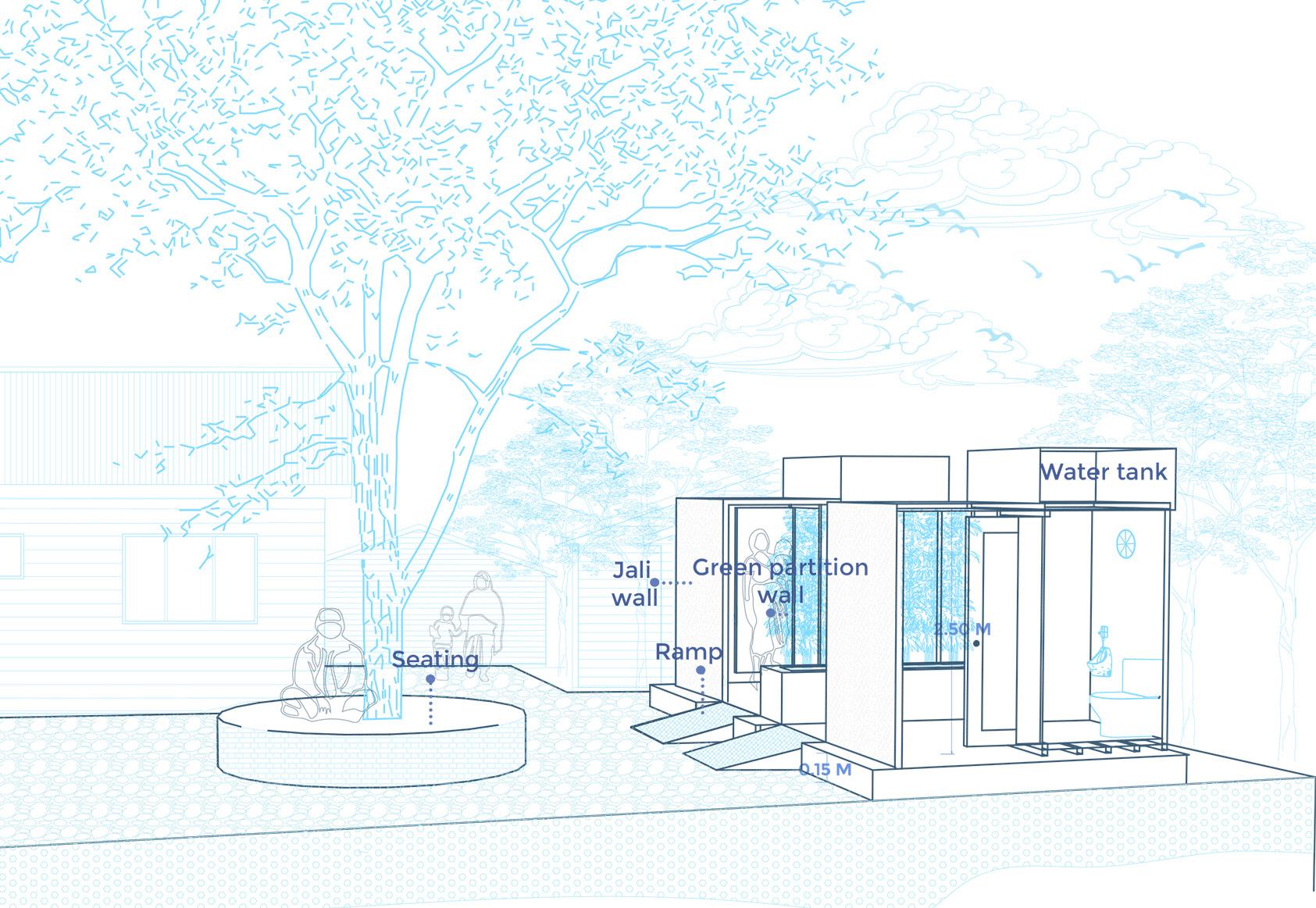
Barmale and Uttareshwar lakefront development
DESIGN DETAIL: Dhobi ghat and waste water treatment
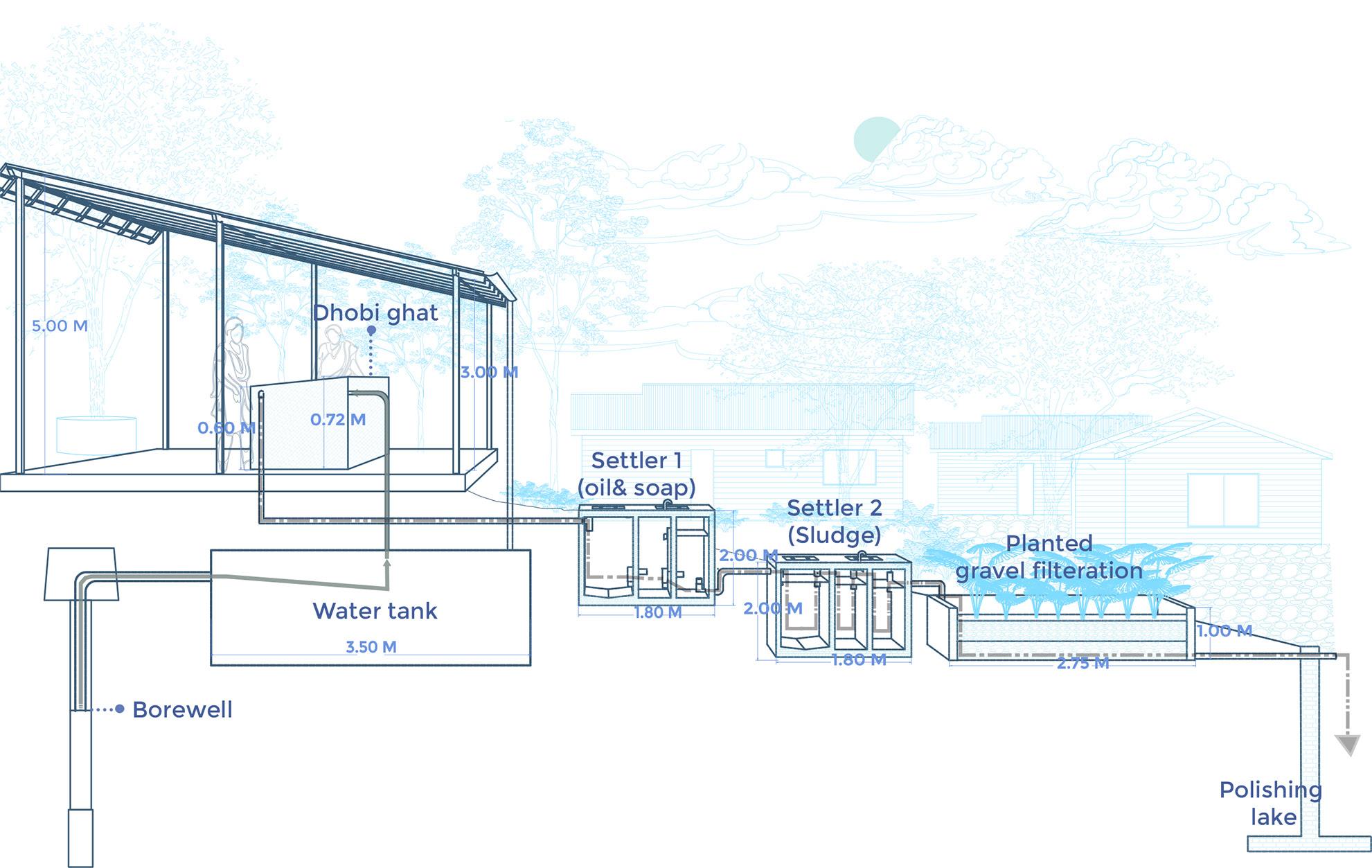
83
Mruga Raut Capstone project 2022
DESIGN DETAIL: Community clothes drying area
ANANT NATIONAL UNIVERSITY
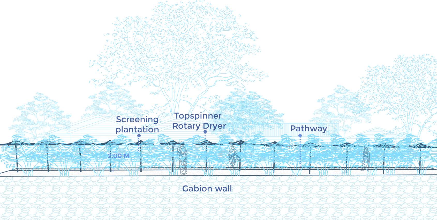
Barmale and Uttareshwar lakefront development
DESIGN DETAIL: Children play area
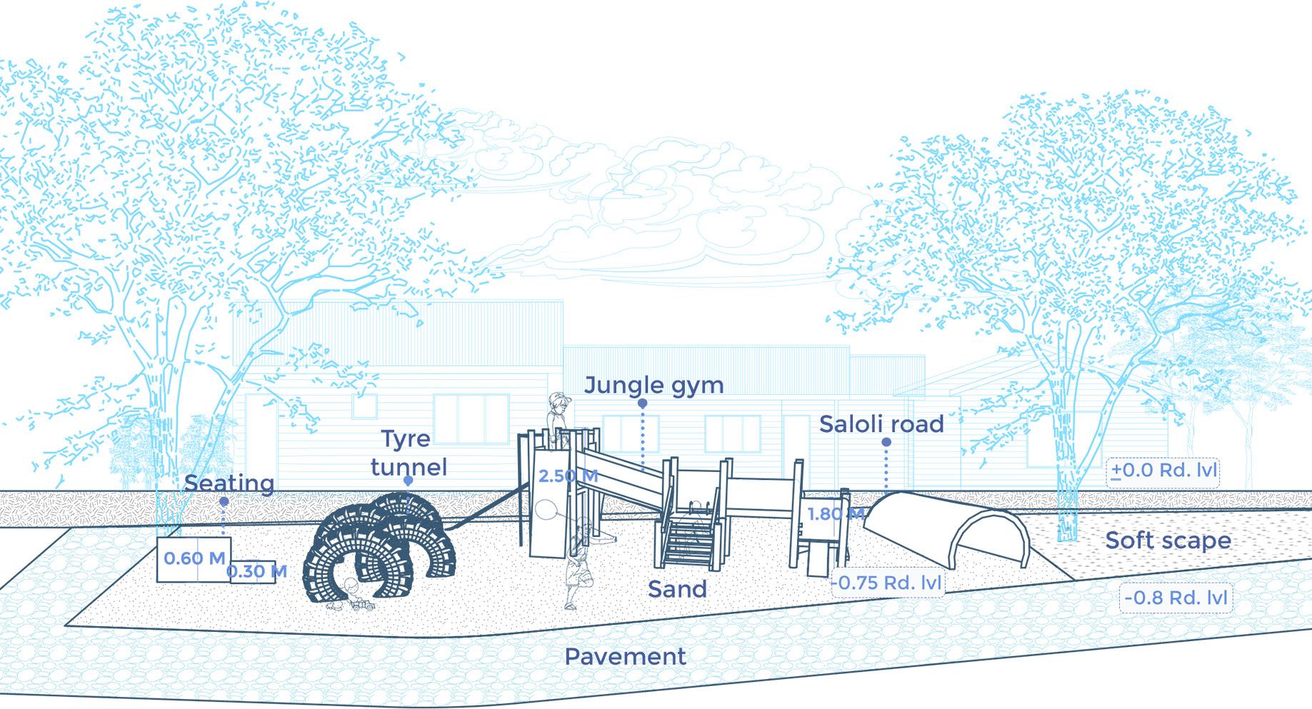
85
Mruga Raut Capstone project 2022
PROJECT PHASING:
Phase- I
The proposal of providing drinking water to the community and improving the road should be carried out as is the primary task in the project’s initial phase.
Phase- II
Phase two involves developing the lakefront and providing the facilities of dhobi ghat simultaneously, starting with the underground services and water connection required.
Phase- III
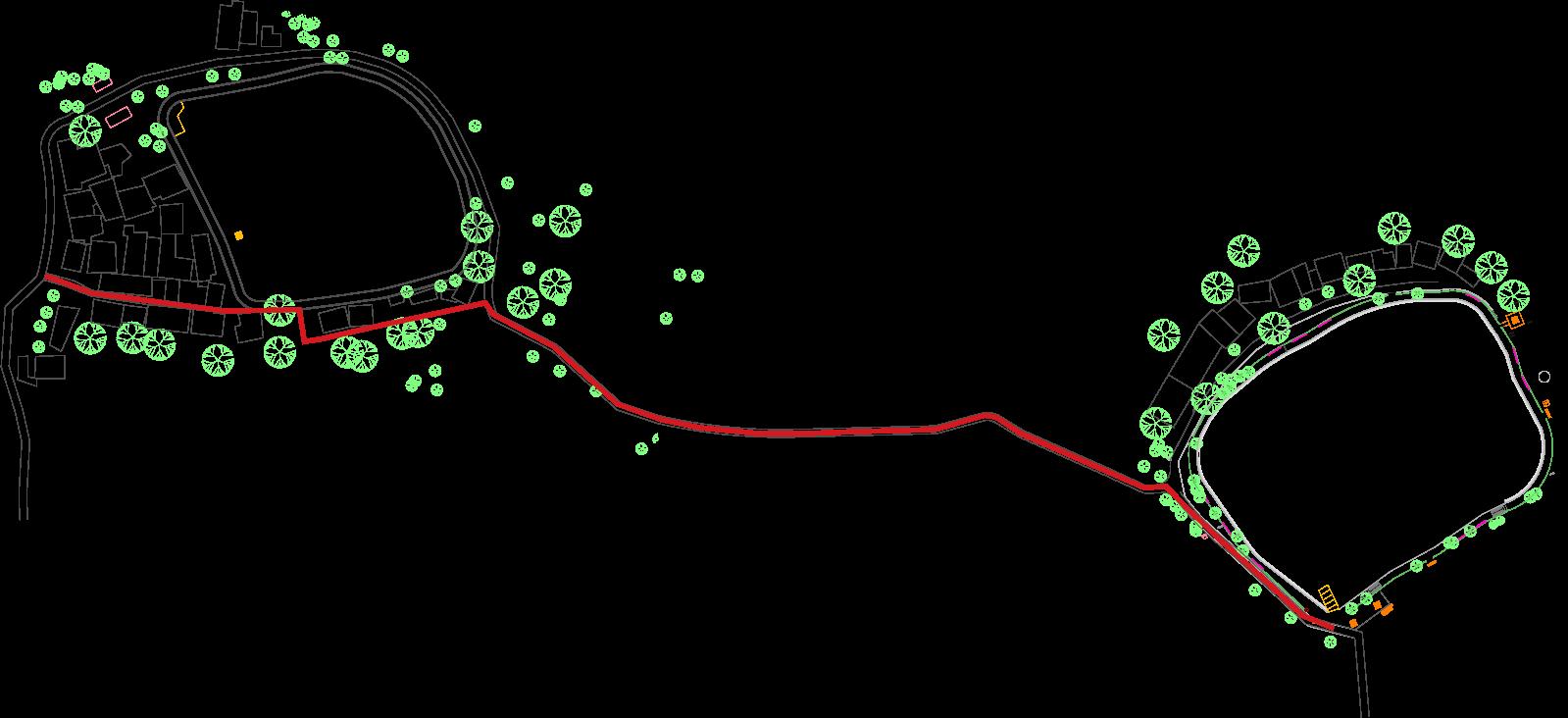
The later stage of the project is creating a social and colorful space around the lake. The landscaping is the majority of the part to be covered in the final phase.
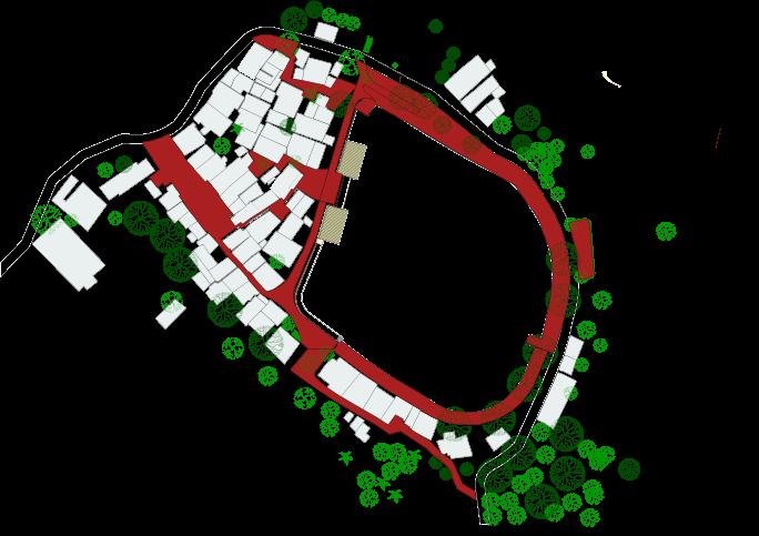
PHASE - I PHASE - II PHASE - III
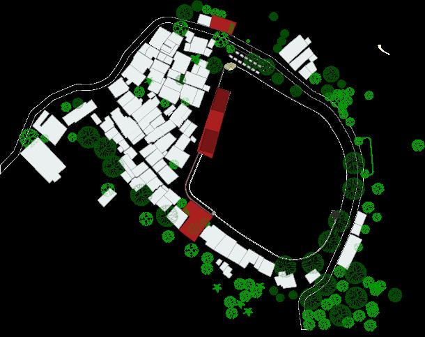
ANANT NATIONAL UNIVERSITY
Barmale and Uttareshwar lakefront development
General Instructions & Work Method Statement: The Site
Works Areas are those areas identified are to these Employer’s Requirements and on the Drawings. Use of the site
•The Site or Contractor’s Equipment shall not be used by the Contractor for any purpose other than for carrying out the Works in the scope of this contract, except that, with the consent in writing of the Engineer, the Site or Contractor’s Equipment such as batching/mixing plants for concrete and bituminous materials may be used for the work in connection with other contracts under the employer.
•Rock crushing plant shall not be used on the Site.
•The location and size of each stockpile of materials, including excavated materials, within the Site shall be as permitted by the Engineer. Stock piles shall be maintained at all times in a stable condition.
•Entry to and exit from the Site shall be controlled and shall be only available at the locations for which the Engineer has given his consent.
•Contractor has to dump all the waste and unusable material at approved designated dumping site of MCC.
•All waste material should be out of the site before the start of next working day.
•Filling of soil should be done in layer only after compaction and approval.
•Filling material sample should be approved before start of filling.
Access to the site
•The Contractor shall make its own arrangements, subject to the consent of the Engineer, for any further access required to the Site.
•In addition, the Contractor shall ensure that access to every portion of the Site is continually available to the Employer and Engineer. the site
•A survey shall be carried out of the Site to establish its precise boundaries and the existing ground levels within it. This survey shall include a photographic survey sufficient to provide a full record of the state of the Site before commencing the work with particular attention paid to those areas where reinstatement will be carried out later on. The survey shall be carried out before the site clearance wherever possible and in any case prior to the commencement of work in any Works Area. The survey shall be carried out by the Contractor and agreed with the Engineer.
Barricades and Sign Boards
•The Contractor shall erect barricades as per Tender Drawing and gates around its areas of operations to prevent entry by unauthorized persons to his Works Areas and necessary identity cards /permits should be issued to workers and staff by the contractor. The Contractor shall submit proposal for barricades of the complete perimeter of all works areas to the Engineer. Painting of the barricades shall be carried out to the design and colors as directed by the Engineer and the Contractor shall carry out re- painting of the entire barricades on a regular basis. No work shall be commenced in any Works Area until the Engineer has been satisfied that the barricades installed by the Contractor are sufficient to prevent, within reason, unauthorized entry. The cost of all this barricade is included in quoted price.
•The types, sizes and locations of project signboards shall be agreed with the Engineer before manufacture and erection. Other advertising signs shall not be erected on the Site.
87
PROJECT MANAGEMENT:
Cost estimate is an important component of the detail DPR as it provides vital input to financial evaluation. Detail cost estimate done after con cept approval & detail engineering. Maharashtra SOR 2020-21 items are majorly used in preparation of cost estimate. Other refer documents are CPWD DSR 2020 & market rate itemMarket quotation collected for equivalent makes and specification.
ANANT NATIONAL UNIVERSITY
Mruga Raut Capstone project 2022
Barmale and Uttareshwar lakefront development 89
06 Annexure
Page- 95-102
Detail Cost estimation Reference
DETAIL COST ESTIMATION:
Cost estimate is an important component of the detail DPR as it provides vital input to financial evaluation. Detail cost estimate done after con cept approval & detail engineering. Maharashtra SOR 2020-21 items are majorly used in preparation of cost estimate. Other refer documents are CPWD DSR 2020 & market rate itemMarket quotation collected for equivalent makes and specification.
 Mruga Raut Capstone project NATIONAL UNIVERSITY
2022 ANANT
Barmale and Uttareshwar lakefront development
93
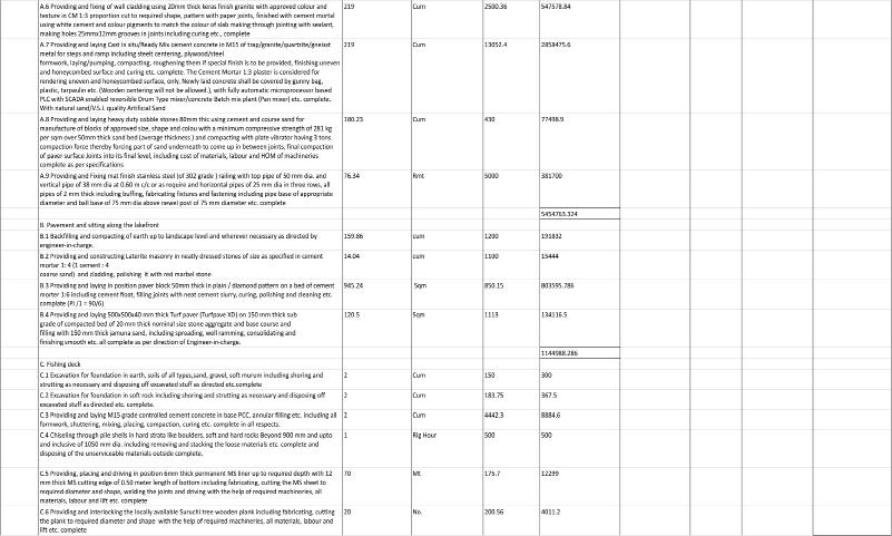 Mruga
Mruga
Raut Capstone project 2022 ANANT NATIONAL UNIVERSITY
Barmale and Uttareshwar lakefront development
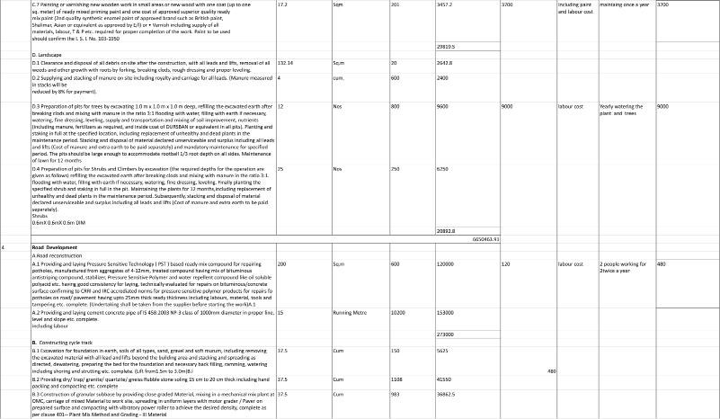
95
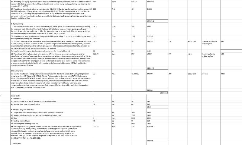 Mruga
Mruga
Raut Capstone project 2022 ANANT NATIONAL UNIVERSITY
Barmale and Uttareshwar lakefront development
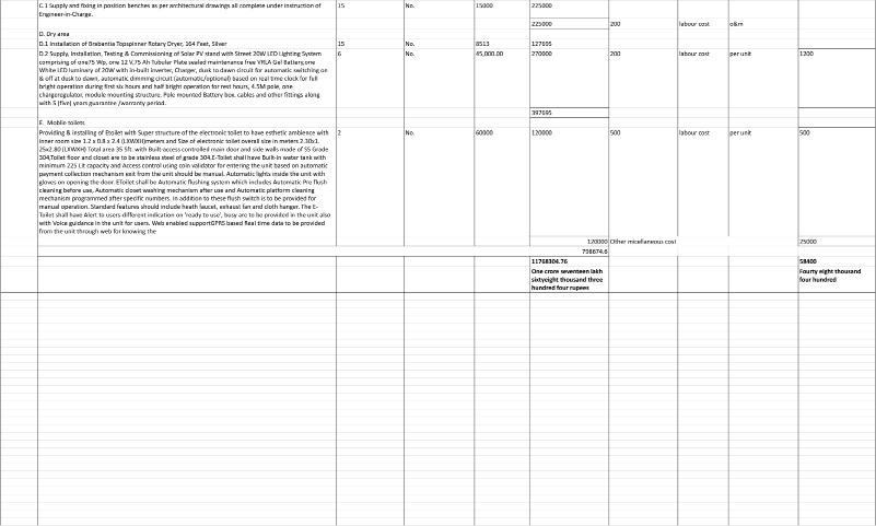
97
Mruga Raut Capstone project 2022
REFERENCES:
• https://idd.karnataka.gov.in/storage/pdf-files/22.Prefea_lake_cons.pdf
• ”Lake Development Project”. Csrbox.Org, https://csrbox.org/India_CSR_Project_Syngene-International-Limited-Lake-Development-Pro ject-Karnataka-_13865.
• KUMAR, ASHOK. “4. CASE STUDY 4.1 Kankariya Lakefront Development, Ahmedabad 4.2 Gopi Talav, Surat 4.3 Mansagar Lake Jaipur 4.4 Lake Pichola, Udaipur - Issuu”. Issuu, https://issuu.com/ashokkumar21028/docs/ashok-thesis_report/s/11442807.
• Thacker, Hency. “Top Lake Rejuvenation CSR Projects In India - The CSR Journal”. The CSR Journal, https://thecsrjournal.in/top-lake-rejuvenation-csr-projects-in-india/.
• ”Kamal Lakefront Development | Welcome To Thane Smart City”. Welcome To Thane Smart City, https://thanesmartcity.in/kamal-lakefront-de velopment/
• ”Dr.Mansee Bal Bhargava | Environmental Design Consultants”. Edc.Org.In, https://edc.org.in/resources/drmansee-bal-bhargava.
• ”Mumbai Metropolitan Region Development Authority - Home”. Mmrda.Maharashtra.Gov.In, https://mmrda.maharashtra.gov.in/home.
• Vvcmc.In, https://vvcmc.in/vvmc/file/sanctioned_dp.pdf.
• ”Town Planning – Vasai Virar City Municipal Corporation”. Vvcmc.In, https://vvcmc.in/en/town-planning/.
• http://vvcmc.in/vvmc/file/CDP-of-VVSR.pdf
• https://www.mohua.gov.in/upload/uploadfiles/files/Appraisal-Vasai-virar19.pdf
• https://urk.tiss.edu/teaching/winter-institute.pdf
• https://www.icontrolpollution.com/articles/a-study-on-sea-water-pollution-levels-in-vasai-region-mumbai-india.pdf
ANANT NATIONAL UNIVERSITY
Barmale and Uttareshwar lakefront development
• “The Slow And Steady Struggle To Save The Bawkhal Of Vasai-Virar”. The Wire, https://thewire.in/environment/bawkhal-vasai-virar-ground water-aquifers-hydrogeology.
• “Case Study Of Kankaria Lake, Ahemdabad”. Amitjaviya.Blogspot.Com, https://amitjaviya.blogspot.com/2016/12/blog-post.html.
•Singh, Shikhar. (2013). Urban Design redefining Cultural Spaces - A Case of Kankaria Lakefront Redevelopment Project..
• https://www.c40.org/case-studies/rajokri-water-body/
• ”Kamal Lakefront Development | Welcome To Thane Smart City”. Welcome To Thane Smart City, https://thanesmartcity.in/kamal-lakefront-de velopment/
• https://indianpoliticsandpolicy.wordpress.com/2020/01/06/the-rajokri-case-study-technical-civil-and-environmental-engineering-architectural-and-financial-details-delhigovernance-aapatwork/
• Christer N et. al. 2016 Evaluating the process of ecological restoration Ecology and Society
•Jukka H 2019 Sediment Nutrients Ecological Status and Restoration Of Lakes, Conference Water Research .
• Sarika B and Pulluri S 2014 Sustainable approach for conserving and managing for urban water bodies An Online International Research Jour nal
• https://www.mohua.gov.in/upload/5c7faf00eac57UT%20Book1.pdf
99

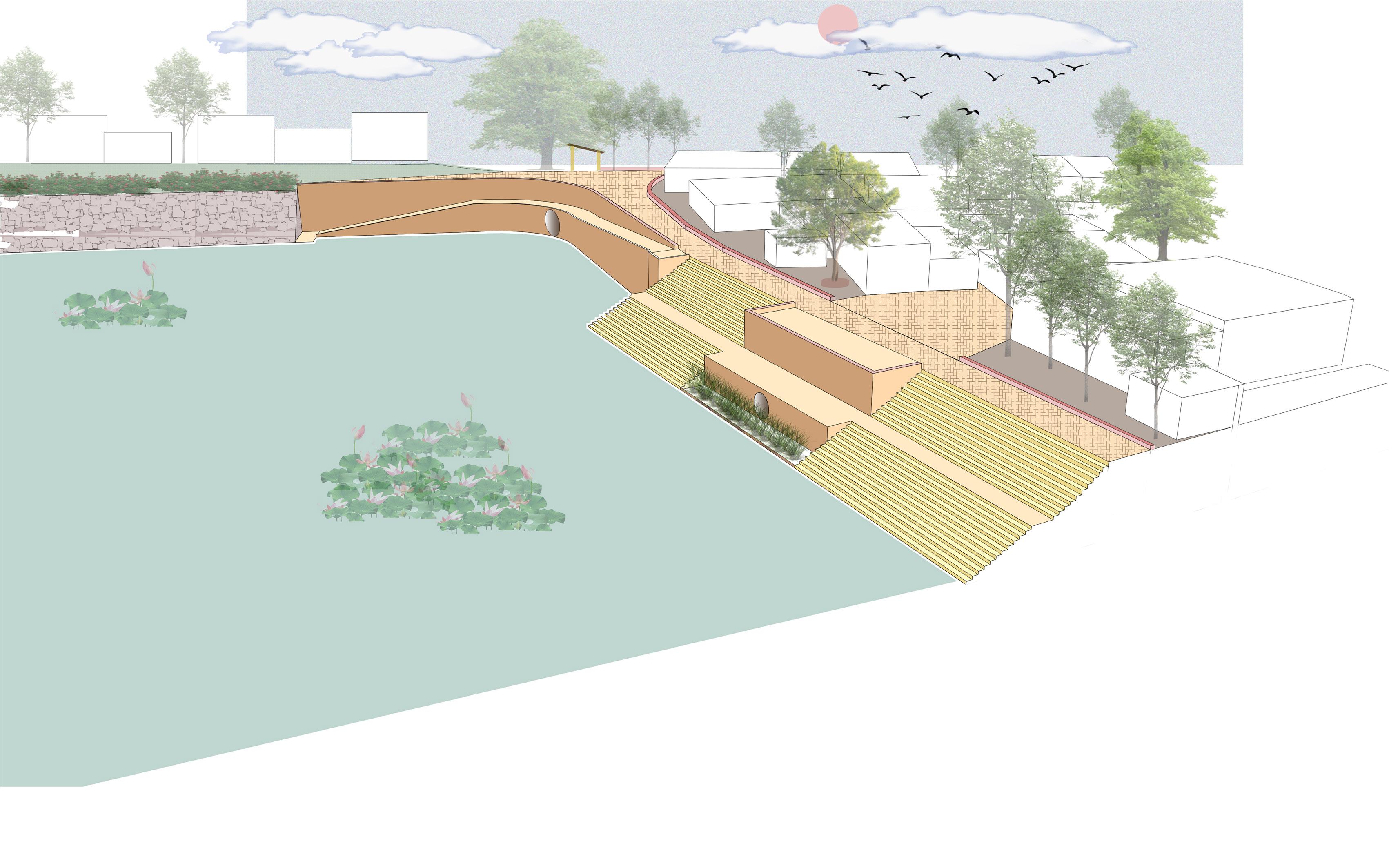
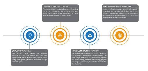
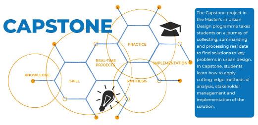 Mruga Raut Capstone
ANANT NATIONAL UNIVERSITY
Mruga Raut Capstone
ANANT NATIONAL UNIVERSITY