
9 minute read
East Central


NEW! BALSAM TRAIL
This 8-mile trail in eastern Itasca County follows trails within the George Washington State Forest. Forested areas vary from densely wooded to harvested pine opening to wide views of the surrounding landscape. This trail follows the Taconite State Trail for 2.5 miles where ATVs and OHMs are allowed. Motorized users are not allowed beyond this section of the Taconite State Trail. The Balsam trail is provided by Itasca County and maintained by the Balsam Trail Blazers.
Soo Pits Trail
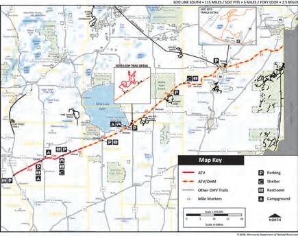
Five miles of trails curve and twist through a landscape of northern hardwoods. The highlight is the pit, where piles of materials and steep rims are ideal for climbing and scrambling practice. Many routes are recommended for more experienced riders. The Soo Pits Trail is accessible off the Soo Line South Trail. The trail is provided by Carlton County and maintained by the Evergreen PAC ATV Club. Distance: 5 miles Difficulty: More Difficult Parking/Trailhead Location(s): From Moose Lake, parking is located a half-mile east on Highway 27 Season: April 1 to November 30 Facilities: Moose Lake: food, fuel, restrooms, lodging More Information: 218-460-7020 Distance: 8 miles Difficulty: Easiest Parking/Trailhead Location(s): Parking is available at the Balsam Store at the intersection of County Road 7 and County Road 8. Parking is also available at Little Moose Trailhead off County Road 337 Season: May 15 to November 1 Facilities: Balsam: food, fuel, restrooms More Information: Art Daly, 218-245-320
Saginaw Grade/Lumberjack Multiuse Trail
The Saginaw Grade/Lumberjack Multi-use Trail is on a repurposed railroad grade from Spafford Park in Cloquet and travels north 10 miles before stopping short of the historic Saginaw area in St. Louis County. Distance: 10 miles Difficulty: Easiest Parking/Trailhead Location(s): Trail parking and access located at Spafford Park off Main Street in Cloquet Season: Year Round Facilities: Cloquet: food, fuel, restrooms, lodging More Information: Eric Senarigh, 218-380-8730
Soo Line South
The Soo Line South Trail stretching through five counties and two states, is the longest single trail in the state at 115 miles. The trail is built primarily on a repurposed railroad grade with flat straightaways and sweeping turns. The eastern portion of the trail in Carlton County is especially scenic with a trestle bridge over the Kettle River and woodsy terrain. Its trail cousin, the Soo Line North, bisects the north-central area of Minnesota. The two intersect in Moose Lake. The Soo Line South also connects to the Red Top Trail, Solana State Forest and Loop, the Soo Pits trails and Foxy Loop, while the counties and local ATV club maintains them. Distance: 115 miles in Minnesota; 8 miles in Wisconsin Difficulty: Easiest Parking/Trailhead Location(s): McGrath (Aitkin County): Moose Lake (Carlton County): Isle (Mille Lacs County): Genola and Hillman (Morrison County) Season: Aitkin, Mille Lacs and Pine Counties: April 1 to November 30; Carlton County: Year Round; Morris County April 1 to October 31 Facilities: Isle / Moose Lake / Willow River / Superior: food, fuel, restrooms, lodging; Genola: food, fuel; Denham: fuel, restroom; McGrath: food More Information: Aitkin: Chris Johnson, 218-927-7364; Carlton County: Jim Gassert, 218-485-4486; Mille Lacs County: Tina Chapman, 612-676-8664, Morrison County: David Lanners, David Lanners, 320-360-4927; Pine County: Mike Weske, 218-461-6040

Red Top Trail
Located between Isle and McGrath, the Red Top Trail has 25 miles of varying terrain for all levels. Beginners will enjoy the sandy, wide trails on the main track while experienced riders can try the tight, technical loops. The popular Adventure Trail loop is a rocky, steep, rugged ride. Riders of all skill levels will enjoy the rocky terrain and sweeping corners of the trail while feeling miles away from civilization. The trail is provided by Aitkin County and local ATV clubs. Distance: 22 miles Difficulty: More Difficult Parking/Trailhead Location(s): Isle (Driftskippers Club House), Redtop, Idun Road and the Snake River campground on Highway 65 Season: May 15 to October 31 Facilities: Isle: food, fuel, restrooms, lodging More Information: Chris Johnson, 218-927-7364
St. Croix State Forest OHV Trails
St. Croix State Forest offers offroad recreation for multiple motorized vehicles. Be sure to know which trails and roads accommodate your vehicle. The 42,000 acres of forest is classified as “limited” for offroad riders. It offers scenic, woodsy rides with views of the St. Croix and Tamarack rivers. The area includes a trail exclusively for winter use. Trails here also connect to the Gandy Dancer. This is a working forest – trees harvested from here become a variety of wood and pulp products. Distance: 26 miles (Mn), 68 miles (Wi) Difficulty: Easiest Parking/Trailhead Location(s): Parking and trail access east of Nickerson, outside Kingsdale or within the St. Croix State Forest Season: Year Round Facilities: Danbury: food, fuel, restrooms, lodging; Duxbury: food, fuel, restrooms More Information: 218-460-7020
Fond du Lac State Forest Trails

Thirty-seven miles of trails wind throughout the 64,000 acre Fond du Lac State Forest. Some sections offer wide, gentle curves while the majority are narrow with tighter curves and corners. Much of the route follows ridges that border wetlands, marshy areas, wooded swamps and shallow wild-rice lakes. Trails located within the forest offer more challenging loops, and a gravel pit provides riders with a large practice area. The Fond du Lac State Forest is classified as “limited.” Trails are maintained by the Minnesota Department of Natural Resources. Distance: 37 miles; 16 miles of forest roads Difficulty: Easiest to More Difficult Parking/Trailhead Location(s): Parking and trail access north of Cromwell, off County Road 120 as well as Gravel Pit Road Season: Year Round Facilities: Cromwell / Cloquet: food, fuel, restrooms, lodging More Information: 218-460-7020
General C.C. Andrews State Forest OHV Trails
Twenty-four miles of ATV/OHM trails meander through the General C.C. Andrews State Forest. With level to gently rolling terrain and smooth sandy soil, this forest offers enjoyable riding for all experience levels. The well-drained soils typically make this one of the earliest forest trail systems to open each spring. Trails are maintained by the Minnesota Department of Natural Resources. Distance: 24 miles designated trail Difficulty: Easiest Parking/Trailhead Location(s): Park at the day-use areas of Dago or McCormick lakes Season: Year Round Facilities: Willow River: food, fuel, restrooms; Sturgeon Lake: food, fuel, lodging More Information: 218-460-7020

Solana Loop and Solana State Forest OHV Trails
The Solana Loop is adjacent to the Soo Line South Trail and within Solana State Forest in Aitkin County. Most of the roads within the forest are signed as open to off-highway vehicles. Temporary closures may happen after major rains. The forest is wooded with mature oaks, featuring gently rolling hills and many swampy areas. The Snake, Rice and Split Rock rivers run through this forest. ORVs on forest roads only. Distance: 15 miles in the Loop; 48 miles of signed forest roads Difficulty: Easiest to More Difficult Parking/Trailhead Location(s): From McGrath, go north on Highway 27 for 6.5 miles, east on County Road 2 for 6 miles, south on County Road 26 for 1.3 miles, and left on 150th Place to parking. Access also available via the Soo Line South trailheads Season: May 15 to October 31 Facilities: Cromwell / Cloquet: food, fuel, restrooms, lodging More Information: Chris Johnson, 218-927-7364
Chengwatana State Forest OHV Trails
The twisty trails in this state forest are primarily for Class 1 ATVs and offroad motorcycles, though the section of the Matthew Lourey Trail within this forest accommodates Class II ATVs. This area of connecting trails has fun names like Redhorse Trail, Grouse Trail and Ramblee Trail. They skirt the Kettle River as it enters the St. Croix, as well as Redhorse Creek. The wide, gentle curves are especially nice for new riders. Forest roads, when marked, are also open to ATV use. Distance: 15 miles Difficulty: Easiest to More Difficult Parking/Trailhead Location(s): From Pine City, go 4 miles northeast on County Road 9, then 9 miles east on County Road 10/Chengwatana Forest Road to parking lot Season: Year Round Facilities: Pine City: food, fuel, restrooms, lodging; Beroun: food, fuel, restrooms More Information: 218-460-7020
Matthew Lourey State Trail

The legacy of Matthew Lourey, of Kerrick, is recognized with this trail connecting three state forests. It was a favorite of Lourey, who died during a tour of duty in Iraq in 2005. ATV use of the trail is not continuous, instead, designated parts of the trail in Nemadji, St. Croix and Chengwatana state forests are for ATV and OHM summer use, with a longer trail connecting St. Croix and Nemadji for winter use. The trail sections within each forest provide access to a greater network of trails. Watch for deer, fox, porcupine, weasel, bobcats and black bears. Distance: 47 miles Difficulty: Easy to More Difficult Parking/Trailhead Location(s): Parking in both Nemadji and St. Croix State Forest Season: Year Round Facilities: Moose Lake: food, fuel, restrooms, lodging; Kerrick / Nickerson / Duquette: food, fuel, restrooms More Information: 218-485-5410

Gandy Dancer Trail
What’s a gandy dancer? It’s old-time slang for railroad crews, and its also the name of a 98-mile-rail-to-trail in Minnesota and Wisconsin. The trail dips into Minnesota for 30 miles, with border crossings in Nemadji and St. Croix state forests. While this trail is mostly arrow-straight, it offers access to the two forests and a wide variety of landscape. The trail is maintained by the Minnesota DNR. Distance: 30 miles in Minnesota; 68 in Wisconsin Difficulty: Easiest Parking/Trailhead Location(s): Parking and trail access available east of Nickerson, outside Kingsdale or within the St. Croix State Forest Season: Year Round Facilities: Danbury: food, fuel, restrooms, lodging; Duxbury / Nickerson: food, fuel, restrooms More Information: 218-460-7020


Nemadji State Forest OHV Trails (Including Washington/Ramsey, Straight Arrows)
Nemadji’s 92,000 acres offer more than 200 miles of trails, including access to Washington / Ramsey, Straight Arrows, segments of Matthew Lourey, Gandy Dancer and neighboring St. Croix State Forest. The area is surprisingly remote, so go prepared with fuel and a plan. This area welcomes all kinds of off-highway vehicles, with some trails exclusively for Class I ATVs and some single-track for offroad motorcycles. Stay on the correct trail for your vehicle. The south of the forest is gently rolling land; the forest gets a decidedly more Northwoods feel the farther north you explore. The Washington / Ramsey Trail narrowly twists, turns and climbs through the forest with amazing overlooks of stream valleys as the reward. Even experienced riders will face challenges on the Straight Arrows Trail, as it blends steep climbs and close-quarters curves with a series of straight stretches as a reprise. The forest is classified as “limited.” The Straight Arrows Enduro Riders and Washington / Ramsey County Wheelers ATV club maintain these trails. Distance: 71 miles (Washington/Ramsey Trail); 30 miles (Gandy Dancer segment); 53 miles (Straight Arrows Trail) Difficulty: Easiest to More Difficult Parking/Trailhead Location(s): From Nickerson, go north on Delong Road/ Highway 23 and continue onto County Road 146 to Gafvert Day-use Area. For Straight Arrows, drive east from Nickerson to parking off Harlis Road in the Nemadji State Forest Season: Year Round Facilities: Nickerson / Moose Lake / Duquette: food, fuel, restrooms, lodging More Information: 218-460-7020


