6 minute read
Take a hike


Take a hike! The Grapeyard Ridge Trail
offers historical landmarks, a train wreck
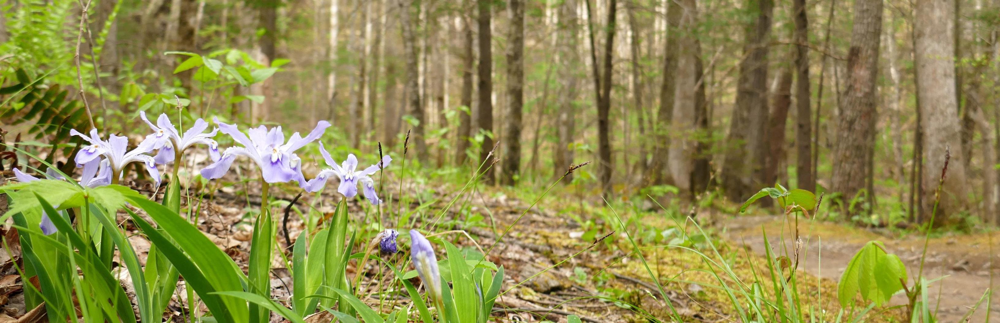
You do not have to be an expert to enjoy some of the 800 miles of hiking trails that run throughout the Great Smoky Mountains National Park (GSMNP) – the park offers several easy trails for visitors who want to enjoy their visit in a different way – away from the hustle and bustle of the abundant touristy things the surrounding area offers. Many of the trails offer panoramic views, old growth forest, historical landmarks and cemeteries, and a perfect way to take in the beautiful fall foliage that the Smokies are known for. One of the less visited areas of the park, Greenbrier maintains a true wilderness feel and harbors some of the oldest forest in the park. It lies just six miles outside of Gatlinburg via Highway 321 North, 12 miles from Cosby via Highway 321 South, in the Pittman Center Community. Once you turn onto the one-lane road, this unique part of GSMNP showcases the Middle Prong of the Little Pigeon River with plenty of pull-offs and parking lots for visitors to take in the beauty – or take a dip in the pristine mountain water, if it’s warm enough! One of the less advertised, but popular trails in Greenbrier is the Grapeyard Ridge Trail that spans 7.6 miles from Greenbrier Road to Roaring Fork Motor Nature Trail. There is a small parking area on the left at the junction of Greenbrier Road and the road to the Ramsey Cascades Trail. From 1933 to 1936, just south of the Grapeyard Ridge Trail at Porters Creek was the Greenbrier Civilian Conservation Corps (CCC) camp. The CCC men built this trail, and you can see some of their handiwork in a rock wall on the right, at the beginning of the trail. This trail gently climbs for about a quarter mile then passes over a small bridge to the Rhododendron Creek Valley. Small roadbeds intersect with the main trail and may throw you off. Take caution and stay straight. Trees along the Rhododendron Creek area are relatively small compared to others throughout the park because this area was heavily populated with small farms and cultivated cornfields.
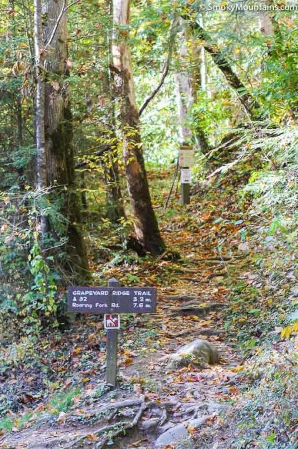
Trail head of Grapeyard Ridge Trail. PHOTO BY:<a href=“https://smokymountains.com/ park/hikes/grapeyard-ridge-trail/” > SmokyMountains. com </a>
From page 4 Settlers Avery Whaley and Louis Messer had homes on the level area where the trail joins Rhododendron Creek. Whaley once owned 61.8 acres, 15 of which supported 50 apple trees and a garden. He had a three-room frame house, a woodhouse, a smokehouse, and a corncrib that he sold for $1,750 to the state for the national park in 1929. The Grapeyard Ridge Trail winds back and forth across the creek six times. In dry weather, rock hopping is not difficult, but take caution if it is raining. Another settler to the area was Walter Parton, country singer Dolly Parton’s grandfather. He once lived above the creek on the left. After crossing the creek for the fourth time, look for fence posts with the remains of barbed wire on them. Near the top of the hollow is a pile of stones that marks the way to the Dodgen-Rayfield cemetery. The trail moves away from the creek and climbs upward toward James Gap. From his home in James Gap, settler Andy Rayfield would hike to Mount Winnesoka and other nearby peaks to tap Fraser fir trees. At the turn of the century, fir sap sold for 75 cents a pint and was often purchased by medicine companies who bottled it as a remedy for burns and cuts, and for internal use as a kidney medicine. At 2.9 miles, the trail climbs to James Gap, then winds down toward the headwaters of Injun Creek. In this creek, you can see the remains of a steam engine, a Nichols-Shepard
No. 4246, which overturned into the creek in the 1920s. According to park sources, the steam engine was brought to Big Greenbrier Cove to saw timber for a new school and crashed on its return to Webb’s Creek. No one was injured in the wreck, but the owner managed to salvage many of the parts. The turbine and a couple of wheels remain in the creek bed today. Injun Creek derives its name from the engine wreck; however, many people refer to it as Indian Creek, as they believe the name comes from the Native Americans who once populated the area. The trail gently goes downhill on the west bank of Injun Creek on what is thought to be an old railroad bed. After a quarter-mile, you will see campsite number 32 on the right of the trail, near the creek. That is a sign that you have traveled 3.2 miles. The Grapeyard Ridge Trail travels down to the campsite and follows a rock wall that borders an old farm site, settled prior to the turn of the 20th century. The trail then begins a long climb, crossing a wet-weather branch, then zigzagging up Grapeyard Ridge. At this point, you can see for yourself why the trail and ridge are called “Grapeyard,” because here, tangled vines form large Gordian knots in the hemlocks, cucumber trees and red oaks. On the ground surrounding the trail are large patches of Galax and dog-hobble. Striped Pipsissewa can be found near the base of large trees, and can be identified by its green, leathery leaves that are mottled with lighter-green veins. As you descend the west side of the ridge, a stream crosses the trail and you reach the site of the Preston Ogle homestead. You can still see signs of a stone foundation belonging to the tub mill he built here. Ogle’s farm consisted of 123 acres, 38 apple trees, a two-room log cabin, and a barn. He was paid $1,900 for this property in 1929, when the state acquired the land for the national park. Several rock walls line Dudley Creek. Just past this creek, a trail forks off to the right to a horse trail that follows the creek down to Smoky Mountain Riding Stables on Highway 321 in Gatlinburg. The trail continues west, as it climbs steeply uphill through more open woods. The trail at the gap is 3,000 feet in elevation, 1,300 feet below the top of Mt. Winnesoka. Just beyond the gap, the trail to the right is another unnamed bridle path leading to Indian Camp Branch. There are a number of fence posts nearby suggesting a former property boundary. After crossing Indian Camp Branch, a long downhill stretch winds through dense rhododendron thickets, then the trail turns to the left. You can begin to hear Roaring Fork, which means you are near the end of the trail. As you continue downward, the trail comes to an intersection marked with a sign. Roaring Fork Motor Nature Trail is only 0.1 miles downhill to the right. The trail ends abruptly in a clearing, which contains a 4-stall barn, corncrib, and cabin. Many hikers use two vehicles, allowing them to complete the entire 7.6 miles of the Grapeyard Ridge Trail. Several hikers utilize the trail from Greenbrier Road and hike to campsite number 32, turn around and travel back to the parking lot in Greenbrier, only hiking a total of 6.8 miles. The trail offers a look into the history of the area and a great way to take in the fall weather. Keep in mind that the leaves change in the GSMNP at higher elevations, reaching their peak color from late September through October. At lower elevations, the colors will reach their peak from mid-October into early November.
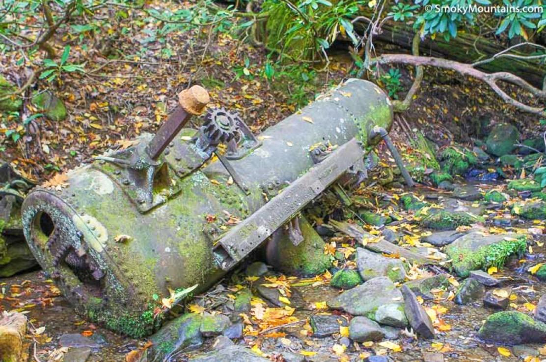
Remains of a steam engine as you travel along Grapeyard Ridge Trail. PHOTO BY:<a href=“https://smokymountains.com/park/hikes/grapeyard-ridge-trail/” > SmokyMountains.com </a>
Editor’s Note: This information was gathered from two books, ‘Hiking Trails of the Smokies’ and ‘The Best of the Great Smoky Mountains National Park: A Hiker’s Guide to Trails and Attractions’. These books, and others, are available at various visitors’ centers in and around the GSMNP. They are also available online through the Great Smoky Mountains Association.


