DEVELOPER PACKET
RD
OSWEGO, OR 97035 Compliments of WFG National Title Insurance Company Customer Service Department
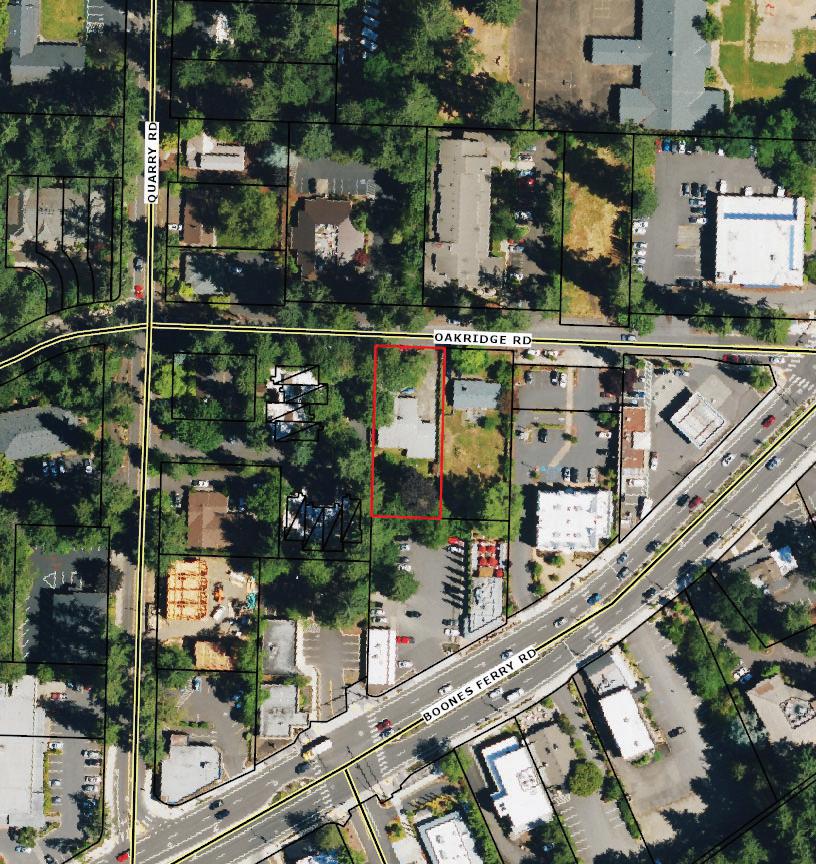
42 OAKRIDGE
LAKE


Property y Details s

Utility y As-Buil ts s (Water r & Sewer) )

Zoning g Information n


Custom m Maps s


Community y Information n
-Demographics
-Traffic Counts


Property y Information n
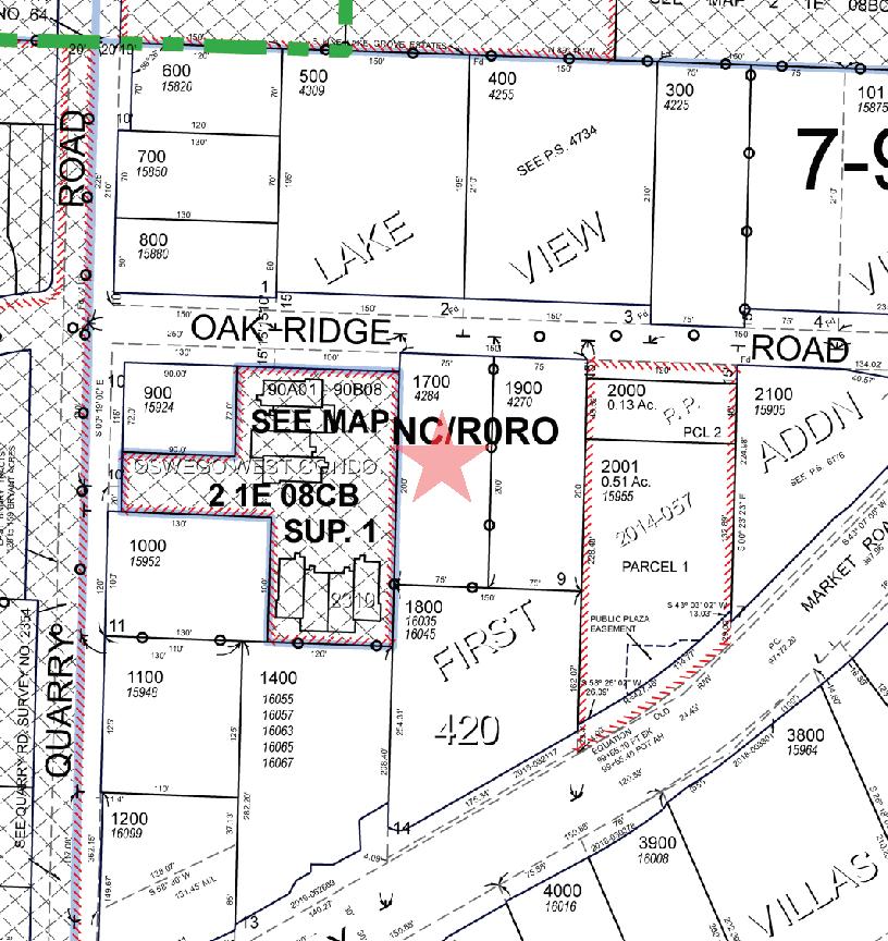
Assessors s Tax x Map p
Vesting g Deed d
The information contained is provided by WFG’s Customer Service Department to our customers, and while deemed reliable, is not guaranteed.

Water r As-Buil t Maps s
City of Lake Oswego
Sewer r As-Buil t Maps s
City of Lake Oswego
The information contained is provided by WFG’s Customer Service Department to our customers, and while deemed reliable, is not guaranteed.

Detailed d Zoning g Information n
NC (Neighborhood Commercial)
R-0 (Residential High Density)
Zoning g Map p
Community y Jurisdiction n
The information contained is provided by WFG’s Customer Service Department to our customers, and while deemed reliable, is not guaranteed.
Sections:
50.11.005 Purpose.
50.11.010 Uses.
50.11.015 Site Development Standards.
50.11.020 Special Requirements.
50.11.005Purpose.
1. Neighborhood Commercial – to provide land near or within residential areas for commercial activities. The uses listed for the Neighborhood Commercial zone in LOC 50.11.010 and 50.11.020 (6), (7) have been determined to implement the Neighborhood Commercial policies of the Comprehensive Plan.
2. General Commercial – to provide lands for commercial activities supplying a broad range of goods and services to a market area which includes the planning area identified in the Comprehensive Plan.
3. Highway Commercial – to provide lands for commercial activities which meet the needs of the traveling public as well as other highway-oriented retail uses which require access to a market area larger than the general commercial zone. This district is not intended for regional shopping centers.
4. Office Campus – to provide lands for major concentrations of regionally oriented offices and employment opportunities for a market area larger than the planning area.
5. East End General Commercial – to implement comprehensive plan policies directing revitalization of the East End Business District. The district should guide and encourage development and redevelopment of the East End Business District.
6. Campus Research & Development – to provide a mix of clean, employee-intensive industries, offices and highdensity housing with associated services and retail commercial uses in locations supportive of mass transit and the regional transportation network.
7. Mixed Commerce – to provide for a mix of uses requiring highway access and which provide a strong visual identity. Intended uses include local and regional convention type facilities, office uses and supporting retail uses. Supporting retail uses shall be limited to less than 60,000 square feet of gross leasable area per building or business in the MC Zone.
(Ord. No. 2316, Added, 03/05/2002)
50.11.010Uses.
Uses:PCXLimitations
Permitted uses.Uses permitted upon the grant of approval of a conditional use permit.
Uses specifically prohibited. Limitations on permitted or conditional uses.
[Cross-Reference: See LOC 50.12.010 – 50.12.025 for Campus Institutional uses.]
1. Residential:
A. Residential Care Housing and Congregate Housing.
GC and NC Zones: A residential use may occupy the ground floor in the GC or NC zones only if a commercial use is located along the street frontage and the residential use is located behind the commercial use. Exception: Lake Grove Village Overlay District.
Lake Grove Village Overlay District – A residential use may occupy the ground floor in the GC zone at street frontage designated Park
Lane, Crossroads Gateway or Campus Woods within the Lake Grove Village Center Overlay District (see Village Character Map, LOC Appendix 50.11A.020-D).
R-0, R-3, and R-5 density except as specifically allowed in LOC 50.11.020
NC
HC, OC, CR&D
Parcels > 6,000 square feet floor area
Parcels ≤ 6,000 square feet floor area
EC
Residential use not allowed on ground floor within the area depicted on Appendix 50.11.010(1)(B).
MC
Residential use at R0 density with a maximum 3.0:1 FAR (4 unit minimum)
No minimum unit requirement.
Appendix50.11.010(1)(B)
Uses:PCX
C. [Reserved]. D. [Reserved]. 2. Retail Sales – Food: A. Food markets, over 25,000 sq. ft. floor area.Uses:PCX
GC (not to exceed 35,000 sq. ft.)GC exceeding 35,000 sq. ft. (not to exceed 45,000 sq. ft.)
NC, OC and CR&D HC
EC (not to exceed 35,000 sq. ft.), see also LOC 50.11.020(6)
MC (not to exceed 60,000 sq. ft. per building or business), see also LOC 50.11.020(6)
B. Food markets under 25,000 sq. ft. floor area.
Uses:PX
NC, GC, HC, EC, MCOC, CR&D
C. Delicatessen, no table service.
Uses:PSpecialDistrictLimitationsfor PermittedUse
NC, GC, HC, OC, EC, CR&D and MC(Not to exceed 20,000 sq. ft. floor area in CR&D and MC zones)
D. Specialized food stores.
Uses:PXSpecialDistrictLimitationsfor PermittedUse
NC, GC, HC, EC, MCOC, CR&D(Not to exceed 20,000 sq. ft. floor area in MC zone)
E. Bakery – where baked foods manufactured elsewhere are sold on the premises.
Uses:PSpecialDistrictLimitationsfor PermittedUse
NC, GC, HC, OC, EC, CR&D and MC (Not to exceed 20,000 sq. ft. floor area in CR&D and MC zones)
F. Bakery, manufacturing – where on-site baked foods are sold within the building.
Uses:PX
< 5,000 sq. ft. floor area
> 5,000 sq. ft. floor area
NC, GC, HC, EC, CR&D and MCOC
GC, ECNC, HC, OC, CR&D and MC
3. Retail Sales – General Merchandise:
A. Over 20,000 sq. ft. floor area, including apparel and accessory, department stores, building supply, garden, sporting goods, furniture, etc.
Uses:PCX
Uses:PCX
GC (not to exceed 35,000 sq. ft.)GC exceeding 35,000 sq. ft. (not to exceed 45,000 sq. ft.)
EC (not to exceed 35,000 sq. ft. floor area per business)
MC (not to exceed 60,000 sq. ft. floor area per building or business)
NC, HC, OC and CR&D
B. 10,000 – 20,000 sq. ft. floor area, including apparel and accessory, department stores, building supply, garden, sporting goods, furniture, etc.
Uses:PX
GC, HC, EC, CR&D and MCNC, OC
C. Under 10,000 sq. ft. floor area, including apparel and accessory, department stores, building supply, garden, sporting goods, furniture, etc.
Uses:P
NC, GC, HC, OC, EC, CR&D and MC
D. Auto sales.
Uses:PSpecialDistrictLimitationsfor PermittedUse X
GC, ECProhibited in the Lake Grove Village Center Overlay District.
4. Retail Sales – Restaurants, Drinking Places:
A. Restaurants, with or without associated lounge.
NC, HC, OC, CR&D and MC
Uses:PSpecialDistrictLimitationsfor PermittedUse
NC, GC, HC, OC, EC, CR&D and MC(Not to exceed 20,000 sq. ft. floor area in CR&D and MC zones)
B. Restaurants – take out only; or which include a drive-in window.
Uses:PCSpecialDistrictLimitationsforConditionalUseX
HCGCIn the GC Zone in the Lake Grove Village Center Overlay District, no more than two restaurants with drive-in service windows are permitted. Use is prohibited in Village Transition Areas (see Village Transition Area Map, LOC Appendix 50.11A.020-B).
NC, OC, EC, CR&D and MC
C. Bar or cocktail lounge not associated with restaurant; use with retail malt beverage license.
Uses:PXSpecialDistrictLimitationsfor PermittedUse
GC, HC, EC, MCNC, OC and CR&D(Not to exceed 20,000 sq. ft. floor area in MC zone)
5. Services – Personal:
A. Laundries & cleaning places.
Uses:PX
NC, GC, HC, EC, CR&D and MCOC
B. Tailor shops & related services.
Uses:PX
NC, GC, EC, CR&D and MCHC, OC
C. Barber & beauty shop, personal care.
Uses:P
NC, GC, HC, OC, EC, CR&D and MC
D. Clothing rental.
Uses:PX
NC, GC, ECHC, OC, CR&D and MC
E. Mortuaries.
Uses:PCX
Without accessory crematoriums
With accessory crematoriums
F. Upholstery shop.
GC, EC NC, HC, OC, CR&D and MC
GC, EC
Uses:PX
NC, GC, ECHC, OC, CR&D and MC
G. Radio & television repair shop.
Uses:PX
NC, GC, ECHC, OC, CR&D and MC
H. Home appliance repair shop.
Uses:PX
NC, GC, ECHC, OC, CR&D and MC
6. Services – Business:
A. Sign shop.
Uses:PX
GC, ECNC, HC, OC, CR&D and MC
B. Adjustment & collection agencies.
Uses:PX
GC, HC, OC, EC, CR&D and MCNC
C. Advertising agencies, including commercial artists.
Uses:PX
GC, HC, OC, EC, CR&D and MCNC
D. Truck & trailer rental and sales of accessories.
Uses:PX
HCNC, GC, OC, EC, CR&D and MC
E. Auto rental (vehicle storage off site in CR&D, MC, EC and GC zones).
Uses:PX
GC, HC, OC, EC, CR&D and MCNC
F. Business and management services.
Uses:P
NC, GC, HC, OC, EC, CR&D and MC
G. Car wash.
Uses:PCSpecialDistrictLimitationsfor ConditionalUse X
HCGC, ECIn the GC Zone in the Lake Grove Village Center Overlay District, car wash facilities shall not exceed a total combined area of 4,200 sq. ft. Use prohibited in Village Transition Areas (see Village Transition Area Map, LOC Appendix 50.11A.020-B).
H. [Reserved].
NC, OC, CR&D and MC
I. Duplicating, addressing, blueprinting, photocopying, mailing & stenographic services.
Uses:PX
GC, HC, OC, EC, CR&D and MCNC
J. Employment agencies.
Uses:PX
GC, HC, OC, EC, CR&D and MCNC
K. Office equipment rental & repair agencies.
Uses:PX
Uses:PX
GC, HC, OC, EC, CR&D and MCNC
L. Equipment rental.
Uses:PX
GCNC, HC, OC, EC, CR&D and MC
M. Equipment service & repair places, appliance small engine.
Uses:PX
GC, ECNC, HC, OC, CR&D and MC
N. Offices housing personnel who provide special services to businesses.
Uses:P
NC, GC, HC, OC, EC, CR&D and MC
O. Private off-street parking facilities (sole use on site, parking garages, etc.).
Uses:PX
GC, EC, CR&D, MCNC, HC, OC
P. Services to buildings (including dwellings), cleaning & exterminating.
Uses:PX
GC, HC, EC, MCNC, OC, CR&D
Q. Telephone answering service.
Uses:P
NC, GC, HC, OC, EC, CR&D and MC
R. Miscellaneous business services, including auctioneers, bail bonds, drafting, detective agencies, notary public & other like services.
Uses:P
NC, GC, HC, OC, EC, CR&D and MC
S. Vehicle repair shops (located entirely within an enclosed building).
Uses:PCSpecialDistrictLimitationsforConditionalUseX
GC, EC (except in Village Transition Areas of the Lake Grove Village Center Overlay District)
GC in Village Transition Areas of the Lake Grove Village Center Overlay District (see Village Transition Area Map, LOC Appendix 50.11A.050-B)
T. Auto service stations (primary use only).
In Village Transition Areas of the Lake Grove Village Center Overlay District, conditional use is permitted as follows: The use shall be an expansion of an existing vehicle repair use. Retail or office uses and a storefront appearance shall be provided along fronting collector and local streets. No direct vehicle access shall be provided from streets adjacent to residential zones. No operational repair bay doors shall face collector or local streets.
NC, HC, OC, CR&D and MC
GC outside the Lake Grove Village Center Overlay District, HC, EC
GC within the Lake Grove Village Center Overlay District
Within the Lake Grove Village Center Overlay District conditional use is permitted as follows: No auto service station shall be closer than 1,000 linear feet to another auto service station. No more than two auto service stations shall be located within a distance of 5,000 linear feet. The number of auto fueling devices shall not exceed eight at any single auto service station. Use prohibited in Village Transition Areas (see Village Transition Area Map, LOC Appendix 50.11A.020-B).
OC, CR&D, MC
U. Accounting, auditing and bookkeeping.
Uses:P
V. Computer services.
Uses:P
W. Printing, publishing and lithographic shop.
Uses:PX GC, HC,
X. Commercial photographic studios.
Uses:P
Y. Research and testing facilities.
Uses:PX
Z. Pet care, daily.
Fully conducted within building
Partially conducted outside building
GC, EC, and HCNC, MC, OC, CR&D
GC, NC, and MCEC, HC, OC, CR&D
7. Services – Finance, Insurance and Real Estate:
A. Financial and banking institutions (including credit agencies).
Uses:PSpecialDistrictLimitationsforPermittedUseX
GC, HC, OC, EC, CR&D and MC
In GC and OC zones in the Lake Grove Village Center Overlay District, financial and banking institutions with drive-through facilities are allowed only when no more than one access to the site from a public street is provided on the parcel. Additional access through abutting parcels is permitted. Financial and banking institutions with drive-through facilities are prohibited in Village Transition Areas (see Village Transition Area Map, LOC Appendix 50.11A.020-B).
B. Insurance and bond carriers, agents, brokers and services.
Uses:P
NC, GC, HC, OC, EC, CR&D and MC
C. Real estate brokers, agents and services.
Uses:P
NC, GC, HC, OC, EC, CR&D and MC
NC
8. Services Lodging Places:
A. Hotels, motels and associated retail uses located within the hotel or motel that are intended to serve the guests.
Uses:PX
GC, HC, EC, MCNC, OC, CR&D
9. Services – Medical & Health:
A. Hospitals.
Uses:PX
GC, ECNC, HC, OC, CR&D, MC
B. Clinic, outpatient, and medical office.
Uses:PX
Uses:PX
NC, GC, EC, CR&D, MC, OC, HC
C. Medical and dental laboratories.
Uses:PX
GC, OC, EC, CR&D, MCNC, HC
D. Orthopedic equipment & supplies, rental, sale & service.
Uses:PX
GC, EC, CR&D, MCNC, HC, OC
E. Veterinarian’s facilities, totally enclosed.
Uses:PX
GC, ECNC, HC, OC, CR&D, MC
F. Other veterinarian facilities.
Uses:PX
GCNC, HC, OC, EC, CR&D, and MC
G. Ambulance service.
Uses:PX
NC, GC, ECHC, OC, CR&D, MC
10. Services – Professional Offices:
A. Professional Offices Examples: architectural, artists studios, engineering (including surveying), law, landscape architecture, other professionals.
Uses:P
NC, GC, HC, OC, EC, CR&D and MC
B. Artists studios, including those that use industrial tools.
Uses:P
NC, GC, HC, OC, EC, CR&D and MC
C. Regional offices & corporate headquarters.
Uses:PX
GC, HC, OC, EC, CR&D and MCNC
11. Services – Amusement:
A. Art galleries.
Uses:PCX
Uses:PCX
GC, EC, MCNCHC, OC, CR&D
B. Arcade gaming (video, pinball, etc.) for amusement purposes.
Uses:PCX
< 2,000 sq. ft. floor areaGC, EC, NC HC, OC, CR&D, MC
> 2,000 sq. ft. floor areaGC, ECNCHC, OC, CR&D, MC
C. [Reserved].
D. Fitness, exercise, and sports facilities (including clubs and studios), and other individual and group exercise/fitness facilities; e.g., studios, dance studios and schools, gyms, and martial arts schools; indoor or outdoor pool; athletic fields for organized competitive games; billiard and pool parlors; bowling alleys; and skating rinks, ice and/or roller.
Uses:PCX
< 5,000 sq. ft. floor areaGC, EC, NC, MC, OC, HC, CR&D
> 5,000 and < 20,000 sq. ft. floor area
GC, MC, CR&DNC, EC, OC, HC
> 20,000 sq. ft. floor areaGC, MCOC, HC, CR&DNC, EC
E. [Reserved].
F. [Reserved].
G. Theaters, indoor.
Uses:PX
GC, HC, EC, MCNC, OC, CR&D
H. [Reserved].
I. Outdoor commercial amusement.
Uses:PX
MCNC, GC, HC, OC, EC and CR&D
12. Services – Educational:
A. Nursery, day care centers.
Uses:P
NC, GC, OC, EC, CR&D and MC
B. Private or public educational institutions.
Uses:PCX
GC, ECNCHC, OC, CR&D, MC
C. Vocational schools.
Uses:PCX
GC, ECNCHC, OC, CR&D, MC
D. Music schools.
Uses:PCX
GC, ECNCHC, OC, CR&D, MC
13. Services – Membership Organizations, Offices:
A. Business and professional, charitable, labor, political, and religious (not including churches).
Uses:PX
GC, HC, OC, EC, CR&D and MCNC
B. Civil, social and fraternal.
Uses:PX
GC, HC, EC, CR&D and MCNC, OC
14. Public Service and Facilities:
A. Major public facilities.
Uses:CP
NCGC, HC, OC, EC, CR&D and MC
B. Minor public facilities.
Uses:P
NC, GC, HC, OC, EC, CR&D and MC
15. Alterations or expansions of non-conforming uses:
Uses:C
NC, GC, HC, OC, EC, CR&D and MC
16. Light Manufacturing, Processing or Assembly of Product: (Light manufacturing is the process when manufacturing is conducted within an enclosed building.)
Uses:PCX
CR&DGC, HC, MCOC, EC
(Ord. 2575, Amended, 01/10/2012; Ord. 2525, Amended, 11/01/2011; Ord. 2552, Amended, 06/15/2010; Ord. 2455, Amended, 04/01/2008; Ord. 2398, Amended, 12/06/2005; Ord. 2370, Amended, 12/16/2003; Ord. 2316, Added, 03/05/2002)
50.11.015SiteDevelopmentStandards.
1. Except as modified by LOC 50.11.020 and replaced by LOC 50.11A.030, Lake Grove Village Center Overlay District, the following site development standards apply in each zone:
a. Required Yards:
Zones
NC, GC, HC, OC, and EC zones
SetbackArea FromLotLine To:
WhenAdjacentto DD,R-5,R-6,R7.5,R-10orR-15
WhenAdjacentto R-0,R-2,orR-3 Zone
A structure25 feet10 feet
Surface parking10 feet10 feet
A vehicular accessway
WhenNot Adjacentto ResidentialZone
none
5 feet5 feet
An accessway shared by property zoned commercial, residential, or public function is not subject to the yard requirement.
b. FAR Maximum:
NC 0.25:1except for the SE quadrant of Grimm’s Corner, as determined by the Comprehensive Plan (see LOC Appendix 50.11-B)
OC 0.30:1
EC 3.0:1
c. Lot Coverage:
NCNone
GC50%
HC50%
OC25%
ECNone
d. Height*
NC, GC, HC, OC Structures placed closer than 60 feet to the property line of a lot which carries any residential zone designation.
Maximum height of 28 feet, or 40 feet minus one foot for each foot less than 60 feet the portion of the structure is from the residential zone, whichever is greater.
All other circumstancesNC – 35 feet
GC – 45 feet
HC – 60 feet
OC – 45 feet
ECLot abuts DD zone40 feet
Structure is within 120 feet of a lot zoned R6 or R-7.5
Structure is within 120 feet to 240 feet of a lot zoned R-6 or R-7.5
The portion of the structure within 120 feet of a lot zoned R-6 or R-7.5: 35 feet **
The portion of the structure within 120 feet to 240 feet of a lot zoned R-6 or R-7.5: 45 feet **
•All other lots60 feet
•Those portions of structures beyond 240 feet of a lot zoned R-6 or R-7.5
* This paragraph applies to LOC 50.11.020.
** The measured distance is exclusive of intervening public right-of-way if any exists.
If a dimension or requirement is not shown it means there is no minimum or maximum, but that a requirement may be established at the time of Development Review Commission review.
2. CR&D Zone.
a. Required Yards.
Minimum setback from all lot lines: 15 feet, except along interior lot lines on a unified site.
(1) The following uses may be allowed within a setback area which fronts on a public road:
(A) Landscaping;
(B) Bikeways, trails, pedestrian walks and plazas;
(C) Access driveways;
(D) Bus shelters and other pedestrian amenities; and
(E) Identification signs.
(2) The following uses may be allowed within setback areas which are adjacent to other site areas:
(A) Landscaping;
(B) Bikeways, trails, pedestrian walks, patios, courts;
(C) On-site directional signs;
(D) Coordinate joint-use circulation drives, parking, loading, recreational activity areas, plazas; and
(E) Coordinated joint-use structures, subject to provisions of the Building Code.
b. [Reserved].
c. Lot Coverage. The maximum lot coverage for all structures shall be 55% of the net site area, after any required dedications for roadway purposes. A minimum of 25% of the developed site area shall be used for landscaping, natural areas or outdoor recreational use areas.
d. Height.
(1) For each CR&D zone the average height of all structures shall not exceed 78 feet. One structure is allowed a maximum structure height of 158 feet. No other structure shall exceed 104 feet. For the purpose of applying these height restrictions, all abutting lots with a Comprehensive Plan designation of CR&D, regardless of ownership, shall be considered as being located in one CR&D zone.
(2) Within 120 feet of property zoned R-7.5, R-10 or R-15, no structure shall exceed 60 feet.
e. Access. No direct access from a lot shall be allowed to Kruse Way or to Kruse Woods Drive.
f. [Reserved].
g. No major trees (a tree with a trunk diameter of at least eight-inch at 24-inch above grade) located within 30 feet of the Kruse Way right-of-way may be removed for landscaping or development purposes under LOC 50.22.080.
3. MC Zone.
a. Required Yards.
(1) Minimum Front Yard Setback: 15 feet. Structures on corner lots shall observe the minimum setback on both streets.
(2) Minimum Rear Yard Setback: None required except when rear yard abuts a more restrictive zone. When rear yard abuts a more restrictive zone, setbacks shall be 15 feet. Ten feet shall be added to the rear yard setback for each 10-foot increment in building height over 35 feet.
(3) Minimum Side Yard Setback: None required except when side yard abuts a more restrictive zone. When side yard abuts a more restrictive zone, setbacks shall be 15 feet. Ten feet shall be added to the side yard setback for each 10-foot increment in building height over 35 feet.
b. [Reserved].
c. Lot Coverage. No limit.
d. Height. 95 feet maximum, except in the MC zone located south of Kruse Way and east of Bangy Road, within which zone for no more than two structures the maximum allowable height is 175 feet. For the purpose of applying these height restrictions, all adjacent lots zoned MC, regardless of ownership, shall be considered as being located in one MC zone.
e. Access. No direct access from a lot shall be allowed to Kruse Way or to Kruse Woods Drive.
f. [Reserved].
g. No major trees (a tree with a trunk diameter of at least eight-inch at 24-inch above grade) located within 30 feet of the Kruse Way right-of-way may be removed for landscaping or development purposes under LOC 55.02.080.
[Cross-References: In EC zone, see also Downtown Redevelopment District Design Standards, LOC Article 50.65; Height Limitation: see also 50.45.010(1)(a).]
(Ord. 2525, Amended, 11/01/2011; Ord. 2455, Amended, 04/01/2008; Ord. 2398, Amended, 12/06/2005; Ord. 2316, Added, 03/05/2002)
50.11.020SpecialRequirements.
1. All business, service, repair, processing, and storage or the display of merchandise on property abutting or adjacent to a residential zone shall be conducted wholly within an enclosed building unless screened from the residential zone by a buffer area by either constructing a fence at least six feet high or the buffer area is planted to create a year-around sight obscuring landscaping that will reach six feet high within two years from the date of planting. Driveway access is permitted through the buffer area.
2. Motor vehicle, recreational vehicles, boat or trailer rental or sales lots shall be drained and surfaced with pavement except in those portions of the lot maintained as landscaped areas.
3. Development of any site in the office campus zone requires an overall Development Plan and Schedule, pursuant to LOC Article 50.71, showing the distribution of the proposed use(s), the general circulation pattern within all lots included in the site and general utility and drainage provisions. The site may be developed in phases, based on the overall site plan.
4. All development in any commercial zone will be developed under a unified site plan. The site plan will identify circulation patterns and access points, method of provision of public services and general placement of lots and structures, general area and type of uses. Proposals with multiple ownerships shall include a written agreement of all owners that development of the site will occur pursuant to the site plan approved.
5. [Reserved].
6. EC and MC Zone Limitation Regarding Large Scale Commercial Uses.
a. In the EC zone, the cumulative square footage of a single commercial business on a site shall not exceed 35,000 square feet.
b. In the MC zone, the cumulative square footage of a single commercial business on a site shall not exceed 60,000 square feet.
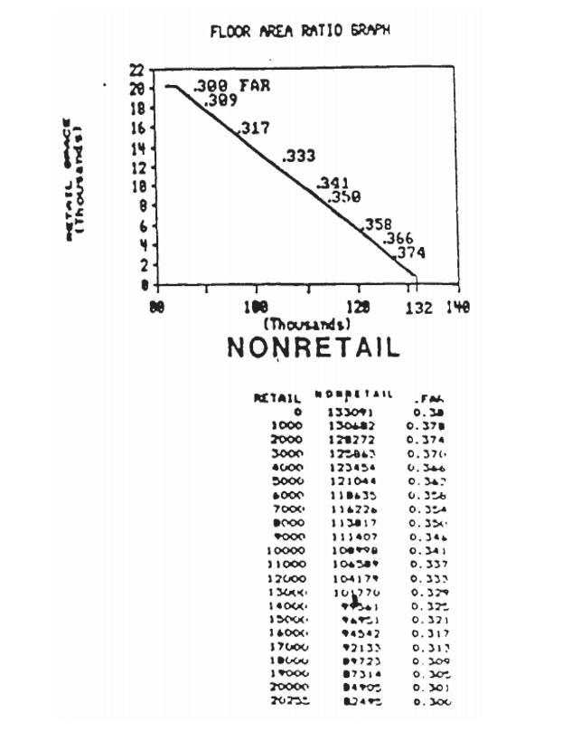
7. Mountain Park Town Center Site. A maximum of 40,000 square feet of retail and service use building area are allowed on the 32-acre site for the uses. The building height limitation is 45 feet and lot coverage is 50%. There are no floor area ratio (FAR) requirements. The uses allowed are those allowed in the NC zone plus the following: adjustments and collection agencies; advertising agencies (including commercial artists); credit agencies; duplicating, addressing, blueprinting, photocopying, mailing and stenographic services; employment agencies; office equipment rental and repair, equipment service and repair places (appliance, small engine); services to building (cleaning, exterminating); financial and banking (no more than 3,500 square feet); regional offices, corporate headquarters; offices of all types of service and membership organizations. A maximum of 492 dwelling units are permitted at a density equal to that allowed in the R-0 zone. A maximum of 3.55 acres on the site will be allowed for church parking facilities. The requirements of the R-0 zone apply to the residential use.
8. Monroe/Boones Ferry Site. A maximum of 131,535 square feet of retail, service uses and office uses are allowed on the 13-acre site. Retail uses shall not exceed 60,000 square feet. The uses allowed are those allowed in the NC zone, plus the retail, service and office uses listed in subsection (7) of this section, and a totally enclosed veterinarian facility. Building height limitation is 45 feet, lot coverage is 50%. There are no floor area ratio (FAR) requirements.
9. I-5/Kruse Way Highway Commercial Site. A maximum of 20 acres of the 35-acre site may be developed. A minimum of 15 acres of the site, including stream corridors and associated wetlands, shall be retained as open space. As a part of the development process, floor area maximums shall be placed upon the development. The site shall be developed by methods that ensure that the traffic generated by the 35-acre site will not exceed the capacity of the intersection of the site with Kruse Way. The City Manager may require traffic management plans in conjunction with any development request for this site in order to preserve the capacity of Kruse Way.
The maximum building height on the site is 75 feet with the overall average building height on the 35-acre site not to exceed 60 feet. Buildings which exceed 60 feet in height shall be located no closer than 120 feet to the boundary of the site. The boundary of the site is defined as the centerline of Kruse Oaks Boulevard on the east, the Kruse Way right-of-way boundary on the south, the State of Oregon right-of-way boundary on the west and the centerline of Ball Creek on the north. The traffic management provisions of subsection (11) of this section apply to this site.
10. Development on the block located in the EC district bounded by A Avenue, Second Street, Evergreen Road and Third Street is not subject to the height limitation stated in LOC 50.11.015 if the following conditions are satisfied:
a. The use of the structure is a mixed use containing dwelling units.
b. The street level commercial uses are designed to provide a "village atmosphere" by the use of landscaping, emphasis on pedestrian access and small scale retail uses.
c. The structure contains parking areas made available to the public and other uses in the area.
11. The following traffic management requirements apply to all uses in the CR&D, MC, OC, GC and HC zones located in the Kruse Way Corridor (the area north of Bonita Road, south of Melrose-Carman, west of Boones Ferry Road and east of I-5, including the southwest quadrant of the Kruse Way/Boones Ferry intersection and the property located between Kruse Way and Galewood Drive).
a. It is the purpose of these transportation management provisions to require that traffic generation limitations will be placed on all development in order to assure the functioning of Kruse Way and the adjacent street system within Service Level "E" at p.m. peaks.
b. A Traffic Management Program (TMP) shall be submitted with each initial or revised development application. The program may include, but is not limited to, the following TM mechanisms: physical site controls on existing traffic, p.m. peak hour exiting traffic limitations, traffic monitoring, restrictions on the number of
parking spaces, flextime, staggered working hours, transit ridership programs, car and van pools, and similar ride share programs.
c. At the time of review of any phase of a development, the developer will provide information from a registered traffic engineer on the then current p.m. peak service level status and volume to capacity ratio of the intersections affected by the development, and also provide information on the p.m. peak traffic that will be generated by the proposed phase of the development and the total development constructed to date.
d. Owners and employers shall be encouraged to implement TMP’s at time of approval. However, when the traffic at an affected intersection consistently exceeds "C" level of service, the TMP must be implemented.
e. A Traffic Management Plan Task Force will be formed, including a representative of each major complex within the Kruse Way Corridor, employers of more than 50 employees, major landowners, representatives of City, Tri-Met and any other person identified by the City. The task force will have authority to review TMP’s of members and recommend TM when appropriate.
f. Notwithstanding the traffic management achievements reached by implementation of the provisions of subsections (11)(a) through (e) of this section, as development increases along the Corridor and the traffic flow on the street system, the City may assert its authority to regulate the use of land to assure all affected property owners, as well as through traffic, are allowed their appropriate share of the traffic capacity.
Necessary measures will be taken to assure a functioning traffic system at Service Level "E" or better and may include, but are not limited to:
i. Green time regulation to facilitate through traffic.
ii. Access fees.
iii. Fines related to access volumes exceeding allocations.
12. [Reserved].
13. [Reserved].
14. Boones Ferry Road/Jean Road Site: The following restrictions and requirements shall apply to the approximately 4.45-acre parcel located at the intersection of Boones Ferry Road and Jean Road (Tax Lot 2400 of Tax Map 2 1E 18BD). The intent of these restrictions and requirements is to create an aesthetically pleasing entry into Lake Oswego. The site and building design shall create an aesthetically pleasing entry by creating a distinct design with features that celebrate entry to the community. The design elements should signal the transition from the city of Tualatin and shall create a sense of separation. Building design elements and landscaping shall communicate a sense of quality, vitality and community. This may be accomplished through the use of visually identifying elements such as building shapes and features, colors, kiosks, flagpoles, signs, landscaping, parking and other design details. Berms and existing mature trees shall be incorporated into the design.
The following specific restrictions and requirements shall apply to the site:
a. The uses allowed shall be those allowed in the NC zone, plus the following: adjustment and collection agencies; advertising agencies (including commercial artists); credit agencies; duplicating, addressing, blueprinting, photocopying, mailing and stenographic services; employment agencies; office equipment rental and repair; equipment services and repair places (appliances, small engines); services to building (cleaning, exterminating); financial and banking; regional offices, corporate headquarters; offices of all types of service and membership organizations.
b. The retail use building area to be located on the east side of Jean Road (i.e., on the parcel consisting of approximately 1.9 acres) shall not exceed 23,000 square feet. The retail use building area to be located on the west side of Jean Road (i.e., on the parcel consisting of approximately 2.5 acres) shall not exceed 31,000 square feet, and no one user shall exceed 26,500 square feet.
c. No building or parking shall be located within 25 feet of Boones Ferry Road right-of-way or within 15 feet of the Jean Road right-of-way. In addition, any loading area located to the west of Jean Road shall not be located within 10 feet of Jean Road.
d. Signs shall be limited to monument and wall signs (excluding signs on awnings) only. Monument signs may be located within the 25 foot setback along Boones Ferry Road and within the 15-foot setback along Jean Road.
e. A minimum of 20% of the net developable acre shall be devoted to landscaping.
f. All utilities shall be located underground.
g. Regardless of the sequence of development of the 0.34-acre or 0.65-acre parcels, vehicular connectivity shall be provided between the 1.9-acre site to the north, and the development on the 0.34-acre and 0.65-acre parcels. A single, shared point of access shall be provided from Jean Way to serve the 0.34-acre and 0.65-acre parcels.
h. Any evergreen tree with a trunk diameter of more than five inches which is removed pursuant to development of the site shall be replaced by a specimen tree of the same variety. The replacement tree shall be of similar size as the tree removed. If a replacement tree of the size of the tree cut is not reasonably available on the local market or would not be viable, replacement may be provided with more than one tree with no individual tree less than four inches in diameter. The number of replacement trees required shall be determined by dividing the caliper of the tree cut by the caliper of viable replacement trees.
15. Jean Way Site: The following restrictions and requirements shall apply to the approximately 0.34-acre parcel and the approximately 0.65-acre parcel located at the northeast corner of the intersection of Jean Road and Jean Way. The intent of these restrictions and requirements is to create an aesthetically pleasing entry into Lake Oswego. The sites and building designs shall create an aesthetically pleasing entry by creating a distinct design with features that celebrate entry to the community. The design elements should signal the transition from the city of Tualatin and shall communicate a sense of quality, vitality and community. This may be accomplished through the use of visually identifying elements such as building shapes and features, colors, kiosks, flagpoles, signs, landscaping, parking and other design details. Berms and existing mature trees shall be incorporated into the design.
The following specific restrictions and requirements shall apply to the sites:
a. The uses allowed shall be those allowed in the NC zone, plus the following: adjustment and collection agencies; advertising agencies (including commercial artists); credit agencies; duplicating, addressing, blueprinting, photocopying, mailing and stenographic services; employment agencies; office equipment rental and repair; equipment services and repair places (appliances, small engines); financial and banking; regional offices, corporate headquarters; offices of all types of service and membership organizations.
b. The retail use building area to be located on Jean Way shall not exceed 4,200 square feet for each parcel, or a combined 8,400 square feet for development contained on both parcels.
c. No building or parking shall be located within 15 feet of the Jean Way right-of-way.
d. Signs shall be limited to monument and wall signs (excluding signs on awnings) only. Monument signs may be located within the 15-foot setback along Jean Way.
e. A minimum of 20% of the net buildable area shall be devoted to landscaping.
f. All utilities shall be located underground.
g. Regardless of the sequence of development of the 0.34-acre or 0.65-acre parcels, vehicular connectivity shall be provided between the 1.9-acre site to the north, and the development on the 0.34-acre and 0.65-acre parcels. A single, shared point of access shall be provided from Jean Way to serve the 0.34-acre and 0.65-acre parcels.
h. Any evergreen tree with a trunk diameter of more than five inches which is removed pursuant to the development of the site shall be replaced by a specimen tree of the same variety. The replacement tree shall be of similar size as the tree removed. If a replacement tree of the size of the tree cut is not reasonably available on the local market or would not be viable, replacement may be provided with more than one tree with no individual tree less than four inches in diameter. The number of replacement trees required shall be determined by dividing the caliper of the tree cut by the caliper of viable replacement trees.
16. Boones Ferry Road/Opposite Jean Way Site: The following restrictions and requirements shall apply to the approximately 2.84-acre parcel located at the intersection of Boones Ferry Road and Jean Way (Tax Lot 600 of Tax Map 2 1E 18BD). The intent of these restrictions and requirements is to create an aesthetically pleasing entry into Lake Oswego. The site and building design shall create an aesthetically pleasing entry by creating a distinct design with features that celebrate entry to the community. The design elements should signal the transition from the city of Tualatin and shall communicate a sense of separation. Building design elements and landscaping shall communicate a sense of quality, vitality and community. This may be accomplished through the use of visually identifying elements such as building materials and features, colors, flagpoles, signs, landscaping, parking and other design details. Existing mature trees may be incorporated into the design.
The following specific restrictions and requirements shall apply to the site:
a. The uses allowed shall be those allowed in the NC zone, plus the following: adjustment and collection agencies; advertising agencies (including commercial artists); credit agencies; duplicating, addressing, blueprinting, photocopying, mailing and stenographic services; employment agencies; office equipment rental and repair; equipment services and repair places (appliances, small engines); services to building (cleaning, exterminating); financial and banking; regional offices, corporate headquarters; offices of all types of service and membership organizations.
b. The total building area to be located on the site shall not exceed 21,850 square feet.
c. No building or parking shall be located within 25 feet of the Boones Ferry Road right-of-way.
d. Signs shall be limited to monument and wall signs (excluding signs on awnings). Monument signs may be located within the 25-foot setback along Boones Ferry Road.
e. A minimum of 20% of the net developable acre shall be devoted to landscaping.
f. All utilities serving any new on-site development shall be located underground.
g. There shall be two main access points for the site from Boones Ferry Road. One shall be directly across from Jean Way and the other shall be northeast of the wetland. The northeast access may be a shared access with the adjacent property. An applicant for development of the northeast portion shall make a good faith effort to obtain a joint access prior to proposing a separate access. If such an effort is unsuccessful, however, a separate access may be approved.
h. Any evergreen tree with a trunk diameter of more than five inches which is removed pursuant to the development of the site shall be replaced by a specimen tree of the same variety. The replacement tree shall be of similar size as the tree removed. If a replacement tree of the size of the tree cut is not reasonably available on the local market or would not be viable, replacement may be provided with more than one tree with no individual tree less than four inches in diameter. The number of replacement trees required shall be determined by dividing the caliper of the tree cut by the caliper of viable replacement trees.
[Cross-References: In EC zone, see also Downtown Redevelopment District Design Standards, LOC Article 50.65; Height Limitation: see also 50.45.010(1)(a).]
(Ord. 2525, Amended, 11/01/2011; Ord. 2455, Amended, 04/01/2008; Ord. 2316, Added, 03/05/2002)
Appendix50.11-A
The Lake Oswego Municipal Code is current through Ordinance 2922, and legislation passed through June 6, 2023.
Disclaimer: The City Recorder's Office has the official version of the Lake Oswego Municipal Code. Users should contact the City Recorder's Office for ordinances passed subsequent to the ordinance cited above.
City Website: https://www.ci.oswego.or.us/ (https://www.ci.oswego.or.us/)
City Telephone: (503) 635-0290 Code Publishing Company (https://www.codepublishing.com/)
Sections:
50.05.005 Zoning Districts.
50.05.010 Zoning Map.
50.05.015 Interpretation of District Boundaries.
50.05.020 Zoning of Annexed Areas.
50.05.025 Comprehensive Plan Map Designations Automatically Applied Upon Annexations; Exceptions.
50.05.030 Effect of Conditions of Approval or Development or Design Regulations Imposed Prior to Annexation.
50.05.005 Zoning Districts.
The City is divided into the following zoning designations:
ResidentialMap Designation
Residential – Low DensityR-15
Residential – Low DensityR-10
Residential – Low DensityR-7.5
Residential – Medium Density (FAN)R-6
Residential – Medium DensityR-5
Residential – High DensityR-3
Residential – High Density (WLG)R-2.5
Residential – High DensityR-2
Residential – High DensityR-0
Waterfront CabanasWR
Design District (Old Town)DD
Mixed Residential/CommercialMap Designation
WLG Residential – High DensityWLG R-2.5/W
WLG Office Commercial/Town/Home ResidentialWLG OC/R-2.5
WLG Office Commercial/Neighborhood
Commercial WLG OC/NC
CommercialMap Designation
Neighborhood CommercialNC
General CommercialGC
Highway CommercialHC
Office CampusOC
East End General CommercialEC
Campus InstitutionalCI
Campus Research & DevelopmentCR&D
Mixed CommerceMC
Industrial (Including Overlays)Map Designation
IndustrialI
Industrial ParkIP
Industrial Park OverlayIPO
Public Use and Open Space LandsMap Designation
Park
OverlaysMap Designation
Planned DevelopmentPD
Resource ConservationRC
Resource ProtectionRP
Willamette River GreenwayGM Center OverlaysMap Designation
Lake Grove Village CenterLGVCO Neighborhood OverlaysMap Designation
EvergreenEO
GlenmorrieGO
Lake Grove R-7.5/R-10 Overlay DistrictLGO
(Ord. 2525, Amended, 11/01/2011; Ord. 2561, Amended, 09/06/2011; Ord. 2558, Amended, 03/01/2011; Ord. 2546, Amended, 06/15/2010; Ord. 2398, Amended, 12/06/2005; Ord. 2316, Added, 03/05/2002)
50.05.010 Zoning Map.
1. The boundaries of the zoning districts established in this Code are indicated on the City zoning map.
2. Amendments to the City zoning map may be made pursuant to LOC 50.75.005. Copies of all map amendments shall be dated with the effective date of the document adopting the map amendment and shall be maintained without change, together with the adopting document, on file in the office of the City Recorder.
3. The City Manager shall maintain an up-to-date copy of the City zoning map to be revised from time to time so that it accurately portrays changes of zone boundaries. A separate map shall also be maintained and show the location of conditional use permits, planned developments and variances. The City Manager shall index on the appropriate map adjacent to such zone change, conditional use, planned developments, or variance, the file number of the document authorizing the same.
(Ord. 2525, Amended, 11/01/2011; Ord. 2316, Added, 03/05/2002)
50.05.015 Interpretation of District Boundaries.
1. Except as provided in subsection (2) below, where due to the scale, lack of detail or illegibility of the City zoning map or due to any other reason, there is uncertainty, contradiction or conflict as to the intended location of any district boundary, the exact location of district boundary lines shall be determined by the City Manager in accordance with the following guidelines:
a. Street Lines. Where district boundaries are indicated as approximately following the centerline or right-ofway line of streets, such lines shall be construed to be such district boundaries.
b. Street Vacations. Whenever any street is lawfully vacated, and the lands within the boundaries thereof attach to and become a part of lands adjoining such street, the lands formerly within the vacated street shall automatically be subject to the same zoning district designation that is applicable to lands to which same attaches.
c. Lot Lines. Where district boundaries are indicated as approximately following lot lines, such lot lines shall be construed to be said boundaries. If a district boundary divides a lot into two or more districts, the entire lot shall be placed in the district that accounts for the greater area of the lot by the adjustment of the district boundary, provided that the boundary adjustment is for a distance of less than 20 feet. If an adjustment of more than 20 feet is required, the change in the district boundary shall be treated as a change of zone.
d. Water Courses. District boundary lines are intended to follow the centerlines of water courses and the shore line of Oswego Lake unless such boundary lines are otherwise fixed on the City zoning map.
2. The boundaries of an RP or RC District shall be determined as provided in LOC Article 50.16.
(Ord. No. 2316, Added, 03/05/2002)
50.05.020 Zoning of Annexed Areas.
1. Zoning designations on newly annexed territories shall be imposed as provided in LOC 50.05.025.
2. The City may consider the zoning for any area considered for annexation at the same time the question of annexation for the area is considered. The notice and hearing procedures shall be the same as if the area in question were located within the City limits. The zoning decision shall not be a final decision for the purposes of judicial review until the date that the approval of the annexation of the area has become effective, or the date of the zoning order if that date is later in time.
(Ord. 2316, Added, 03/05/2002)
50.05.025 Comprehensive Plan Map Designations Automatically Applied Upon Annexations; Exceptions.
1. The Lake Oswego Comprehensive Plan Map provides for the future City zoning of all property within the City’s Urban Service Boundary. In cases where the Comprehensive Plan Map requires a specific Zoning Map Designation to be placed on territory annexed to the City of Lake Oswego, such a zoning designation shall automatically be imposed on territory as of the effective date of the ordinance annexing such territory to the City. The City Manager shall modify the zoning map accordingly. In cases where the Comprehensive Plan Map does not require a specific Zoning Map Designation to be place on territory annexed to the City, the City Manager shall prepare an application and recommend a specific Zoning Map Designation to the Planning Commission with all due speed following the effective date of an ordinance annexing such territory to the City of Lake Oswego. The Planning Commission shall hear the application pursuant to LOC 50.75.005.
2. Where the Comprehensive Plan Map indicates an RP or RC District Designation on territory proposed for annexation, the City shall notify the owners of the annexing territory that they have 20 days prior to the date of the initial public hearing on the annexation, to contest the designation pursuant to LOC Article 50.16. No fee shall be charged for such review. If following review, the decision maker determines the property was improperly designated, the RP or RC designation shall be removed.
3. When evidence indicates that a resource that potentially qualifies for an RP or RC District Designation exists on territory to be annexed, the City may conduct an ESEE Analysis and determine whether such a zone should be imposed pursuant to LOC Article 50.16. City staff may request a delay in the effective date of annexation to complete review.
(Ord. 2525, Amended, 11/01/2011; Ord. 2316, Added, 03/05/2002)
1. Purpose; Definition.
a. The purpose of this section is to require owners of non-conforming uses, structures, or parcels annexed into the City of Lake Oswego to continue to comply with the use, design or development standards imposed by the prior jurisdiction until such time as the use, structure, or parcel is modified or developed under City development standards.
b. For purposes of this section, "prior jurisdiction" shall mean the County or City that had zoning jurisdiction upon the parcel prior to its annexation to the City of Lake Oswego.
2. Compliance with Prior Jurisdiction Requirements. Following annexation of a parcel into the boundaries of the City of Lake Oswego, the owner of a parcel shall comply with the use limitations, development or design regulations, or
conditions of approval applicable to the use, structure or parcel imposed by the prior jurisdiction prior to annexation of the parcel into the boundaries of the City.
3. Interpretation of Prior Jurisdiction Requirements. In the event it is necessary to interpret the design or development standards, or use limitations of a prior jurisdiction, or any condition of approval granted by a prior jurisdiction, the interpretation shall be made in the manner provided by LOC 50.04.010 or LOC 50.86.015.
4. Modification of Conditions of Approval. The owner’s obligation to comply with the Conditions of Approval of a development permit issued by a prior jurisdiction may be modified following annexation of the parcel into the City boundaries the same as if the Conditions were imposed by the City, in the same manner as provided in LOC 50.86.025, except that "hearing body or City Council" shall be construed to mean the final approving authority of the prior jurisdiction.
Except to the extent a condition of approval is modified pursuant to this subsection, the prior jurisdiction’s use limitations, and development or design regulations shall continue to apply to the use, structure or parcel.
5. Modification of Use, Structure or Parcel to Comply With Applicable City Use, Design, or Development Regulations. A property owner may seek modification of the requirements of a development permit, including use, design or development regulations, issued or imposed by the prior jurisdiction for the purpose of complying with comparable City use, design or development regulations. Such modification shall be in accordance with LOC 50.86.025
Except to the extent the use, structure or parcel complies with City requirements following modification of development permit as provided under this subsection, the owner shall comply with the prior jurisdiction’s use limitations, and development or design regulations.
6. Effect of Compliance with Prior Jurisdiction Requirement, or Modification Upon Non-Conforming Status. This section shall not be construed as remedying the non-conformance of any use, structure or parcel with the use limitations, design and development requirements of this Code. Notwithstanding the compliance of the owner with this section, the structure or use shall nevertheless be deemed non-conforming and shall be subject to the provisions of LOC 50.70.005 (2) and LOC 50.70.020
[Cross-References: LOC 50.70.005 - Non-Conforming Use, Structure Defined; Rights Granted; For annexed parcels, see LOC 50.05.030 - Effect of Conditions of Approval or Development or Design Regulations Imposed Prior to Annexation.]
(Ord. 2346, Add, 06/10/2003)
The Lake Oswego Municipal Code is current through Ordinance 2922, and legislation passed through June 6, 2023.
Disclaimer: The City Recorder's Office has the official version of the Lake Oswego Municipal Code. Users should contact the City Recorder's Office for ordinances passed subsequent to the ordinance cited above.
City Website: https://www.ci.oswego.or.us/ (https://www.ci.oswego.or.us/)
City Telephone: (503) 635-0290 Code Publishing Company (https://www.codepublishing.com/)

ClackamasCounty
T2SR1ES08
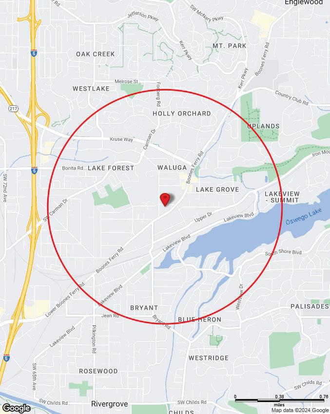
Latitude:45.410523,Longitude:-122.720888
Tax
R
Tax
Building


Oregon
Local Zoning NC/R-0
Generalized Zoning MUR
Classi ed Zoning MUR1
Watershed JohnsonCreek
Sub-Watershed OswegoCreek-WillametteRiver
Basin Willamette
Sub-Basin LowerWillamette
Flood Plain Outside
Wetland Not inawetland
Urban Growth Boundary Inside
Urban/Rural Reserve Reserve
600Northeast GrandAvenue,Portland,OR97232
503-797-1742
drc@oregonmetro.gov
© OregonMetrowww.oregonmetro.gov/rlis
ThisWebsiteisofferedasapublicservice,integratingvariousgovernmentrecordsintoaregion-widemappingsystem.Thepropertyassessment recordsareamulti-countyintegrationofClackamas,MultnomahandWashingtonCountyrecords.MetroMapblendseachcounty'srecordsintoa commondatabaseonaquarterlybasis.Therefore,tovieweachcounty'sof cialrecords,gototheirrespectivewebsitesorof ces.Theother MetroMapdataarederivedfromcity,county,state,federalandMetrosources.Themetadata(dataaboutthedata)areincludedonthissite, includingthesourcestobeconsultedforveri cationoftheinformationcontainedherein.ItdescribessomecaseswhereMetroblendscityand countyrecordsbygeneralizingthedisparities.Metroassumesnolegalresponsibilityforthecompilationofmulti-sourcegovernmentinformation displayedbyMetroMap.Usersofthisinformationarecautionedtoverifyallinformation.
Topography y
Water r Features s
Aerial l
Aerial l Environmental l
Community y
Transit t
Vacant t Land
The information contained is provided by WFG’s Customer Service Department to our customers, and while deemed reliable, is not guaranteed.
Tax Lots
Subject Property
Streams
Flood Plain
Wetlands
Rivers
PA RKHILL ST DOUGLAS WAY
HALLMARK DR
COLLINS WAY
RED CEDAR WAY
OAKRIDGE RD
SW OAKRIDGE RD
SWOAKRIDGE RD
REESE RD
SWBOONES
B
MURWOOD CT
SUNWOOD CT
LAKE GROVE AVE
Christa McAuliffe Academy - School of Arts and Sciences Lake Grove LEEP Lake Grove Elementary
KinderCareLake Grove
DANIELWAY
S
SW B ON TA RD
CARMAN DR
SW CARMAN DR
LANGFORD LN
CARMAN GROVELN
0320640160Feet
SW BONAI
SW OAKR DGE RD
HALLM A RK DR GREYSTOKE DR CARMANDR SW OAKRIDGE RD LANEWOOD ST HERITAGE LN KRUSEWAY DOUGLAS WAY BONITA RD LDNAC EWO O D C T LAKE GROVE AVE UPPER DR COLLINS WAY PARKHILL ST SWWALUGA DR MERCANTILE DR BEASLEY WAY SPRING LN YORKSHIRE PL RED CEDAR WAY LOWER DR SUNSETDR W EMBLEY PARK RD G R AEF CIR HARVEY WAY FIRWOOD RD SW OAKRIDGE RD DOUGLAS CIR COLLINS WAY WHITE OAKSDR GALEWOOD ST ROYAL OAKS DR Pennington Park Waluga Park Waluga Park Lake Grove Swim Park This map is a copy of public record and is provided solely for information purposes. WFG National Title assumes no liability for variations, if any, in dimensions, area or location of the premises or the location of improvements. Customer Service Department 12909 SW 68th Parkway, Suite 350 Portland, OR 97223 (503) 603-1700 cs@wfgnationaltitle.com
HARTFORD PL
MANCHESTER DR
CARMANDR S
OAKRIDGE CT
SW BONITA RD UPPER DR
ROYALOAKSDR
HERITAGE CT STONE AVE
WALUGADR
TRILLIUM WOODS
OAKRIDGE RD
SW OAKRIDGE RD
TRILLIUM WOODS
TRILLIUM WOODS
OAKRIDGE RD
BOONESFERRYRD OAKRIDGE RD
OAKR DGE RD
UPPERDR W M E A D O W A V E
WALUGA DR
SW WALU G A DR
BROOK CT
W EST SUNSET DR
BONAIR E A V E
WASHINGTON CT
BONITA RD ELEANORCT
SW MADRONA ST
BOONES FERRYRD
SWBOONES FERRYRD
WEST SUNSET DR
WEST SUNSET DR
W EST SUNSETDR
SWBOONES FERRYRD
BOONESFERRYRD
UPPER DR
BOONESFERRYRD
UPPER DR
UPPER DR
UPPER DR
SWUPPER DR
UPPER DR
COUNTRYWOODSCT CTNOLA
REESE RD
DIVISION CT
BO ON ES W AY
TWIN F IR RD
DEVONSHIRE
EDGEMONT RD
MURWO OD CT
SUNWOOD CT S AB INA CT
LAKEVIEWBLVD
SOUTH SHORE BLVD
ALLENRD
MAPLE CIR
SWOAKRIDGE
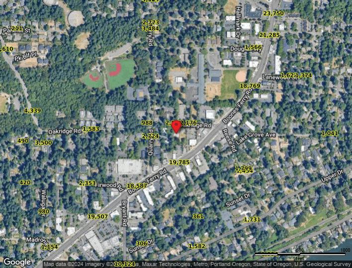
Demographics s
Traffic Counts s
The information contained is provided by WFG’s Customer Service Department to our customers, and while deemed reliable, is not guaranteed.