

PORTFOLIO OF SELECTED WORKS
NAGMA MANOHARAN
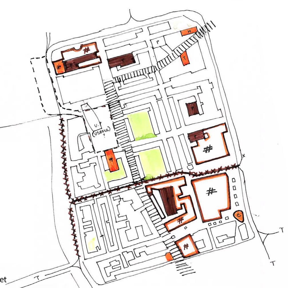
Concept sketch design produced for an urban planning project
1. URBAN DESIGN
De-cluttering Neighborhoods- Designing for climate resilience - The Lijnbaan , Rotterdam , Netherlands
2. ENVIRONMENTAL PLANNING
Reconnecting with the sea :Reimagining the coastline of Chellanam, Kerala India
3. LANDSCAPE DESIGN
Landscape Masterplan, Planting design, construction drawings
Deconstructing the landscape Immersive Playscapes
Community engagement, Tactical urbanism
Nurturing Neighborhoods: creating child friendly streets
5. RESEARCH
1. URBAN DESIGN
De-cluttering Neighborhoods - Designing for climate resilience in Lijnbaan , Rotterdam


SITE STUDY AND ANALYSIS
1. MAPPING THE LIJNBAAN
1.1 THE ECOLOGICAL FABRIC
The Major green corridors in the area run around the perimeter of the block. There is only one dominant corridor within the block which is Karel Doormanstraat. There is lack of West- corridors within the block which loses the opportunity of connecting with nearby neighborhoods.

Cluttered courtyards
However, most of the trees planted along thegreen corriodors are monoculture and provides no habitat for biodiversity.
Key
Single species ( monoculture ), not diverse Multi- species , very bio-diverse


Unlike the main streets in the city centre that lack diversity, certain courtyard spaces within or enclosed by housing blocks are the spaces that provide habitats to many birds and animals. Here the trees are like groves, with mixed variety and form , almost creating a forest habitat. However, not all these spaces are accessible to the public and have varying degrees of privacy


Figure 2. Missed potential of open soils within courtyard spaces which are currently being built on with parking garages, used for back end services and some as small community gardens
The areas with open soils allowing permeability are less prone to flooding , have cooler mean temperature and lesser relative humidity when compared to areas with hard paved soil.


Clean soil that is covered upon Open soils that are contaminated

Existing N02 polution that can contiminate the soil
1.2
Accessibility
The lijnbaan is pedestrian friendly. However, there are conflict points between vehicular/ tram and pedestrian flows making it unsafe for pedestrians. The traim line also runs through one of the areas with the most public footfall, removing the potential of the space as a public place.
Safety
The loading areas to either side of the main public corridor in lijnbaan are considered to be unsafe as there is no active programs or functions that call for eyes on the street

From the study it can be seen that at present the ground in the site area provides no opportunity for social nor ecological networks. This is mainly because it is cluttered with infrastructure that removes potential for quality space from the lijnbaan area.
2.1 AIM
How can we de-clutter the Lijnbaan to make way for more open soil?


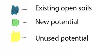
2.2 OPERATIVE STRATEGIES
Strategy 1 ( figure 10):
Reduce the clutter on the surface and subsurface : Rethinking mobility, parking and what arethe redundant and obsolete infrastructures

increasing filteration into soil KEY water buffer storage areas increasing green cover urban food gardens phytoremediation
Strategy 2 (figure 11): Defining the function of the new open space.
Strategy 3 (figure 12):
Re-programming building programs to respond with the new open soil
Figure 14 shows how all the new open soils also must be designed for climate adaptation especially for water. From the diagram it can be seen that Karel Doormanstraat would be an important street in the open space network. Hence it is important to ask what the program of Karel Doormanstraat might become in response to the new open space.
Will Karel Doormanstraat become a liveable neighborhood street with it’s new open spaces or will Lijnbaan become the new liveable neighborhood street?


Reconnecting with the sea: Reimagining the coastline of Chellanam, Kerala, India

EXISTING PRACTICES OF COASTAL DEFENCE


PROPOSED PRACTICES OF COASTAL DEFENCE


4. LANDSCAPE DESIGN
Deconstructing The Landscape : Immersive Playscapes
Crookes Valley Park: The Constructed Landscape
At first impression the park is a formal setting with the landscape remaining largely monotonous throughout the journey with restricted paths and acitivities designed to be contained within specific spaces. Due to this less variety in terms of vegetation and topography , the biodiversity value and nature of the activities is poor. However, one may accidently stumble into a few incidental spaces which seem to provide more affordance and are engaging spaces that give a clue as to the language of spaces that people resonate with more.
Creating an identity: Inspiration from the site context
CVP surrounded by Weston Park, Ponderosa and the sports ground and acts as atransient space between them. Ponderos park has small niches for excercise while the sports ground has organised and structured play only for adults. Hence, crookes valley park unlike its immediate contexts has the opportunity to become an inter-generational space that is more natural in its movement and topography and engages the public with activties that connect them with nature whilst also instilling a sense of learning value.


Visually connected spaces for safety
Berms are designed to act as a barrier to the winds as well as the nests for birds on the lake and encloses an area which becomes a multi-functional space for different types of activities like badminton which wont be affected by wind anymore.
Conceptual diagrams


Nurturing Neighborhoods
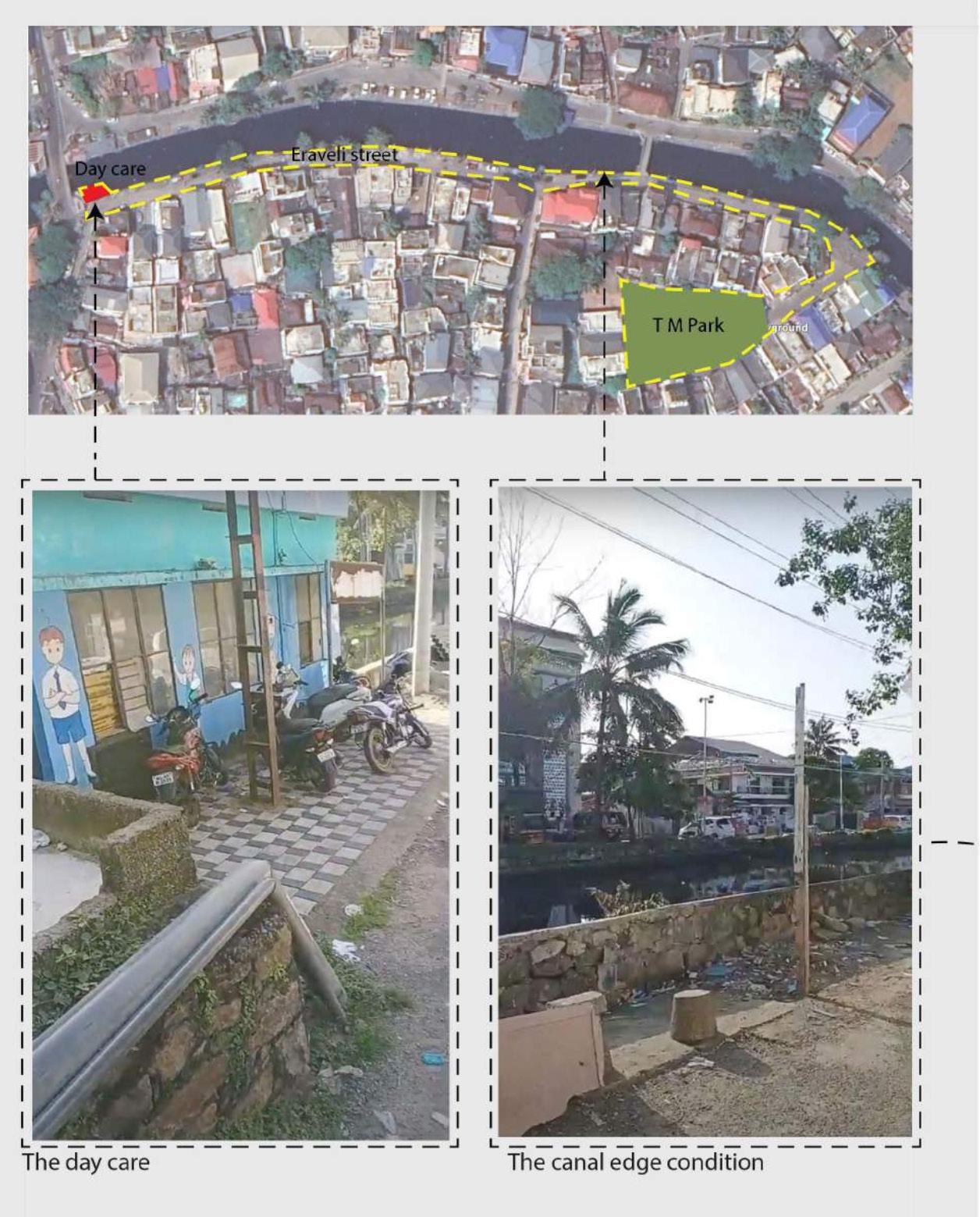

Nurturing neighborhoods is part of the smart cities mission Inida that aiamed at promoting the creation of child firendly streets in our neighborhoods. While working in cochin smart mission in Kerala in India, I developed the proposal for the redevelopment of Eraveli street in Kochi, which had a local nursery (day care) and was the main street tha tthe children of the neighborhood used to commute through. The goal of the project was to design through community centered approach and through tactical urbanism, test and try which design solutions work best for the community.


PROPOSED DESIGN AND PILOT STUDY IMPLEMENTATION USING TACTILE URBANISM STRATEGIES

Evaluating the Planning and design decisions behind implementing Tiny Forests in England


SUMMARY
The need of accessible green space in urban areas post pandemic has been realised for both restorative qualities as well as for coping up with climate change(Collins et al., 2022). Since then, a lot of afforestation projects have popped up across cities in the world but many lack an understanding of the reality of achieving targeted values through the tree planting and lack the understanding of the urban forest designs that are best fit to achieve these values(Roman et al., 2020).

This research focuses on the tiny forest movement, an afforestation movement by Earthwatch Europe which is fast gaining popularity in England. Since the movement is quite new, it is essential at this stage to evaluate the claimed benefits it offers and understand how the design of the tiny forest facilitates these benefits.
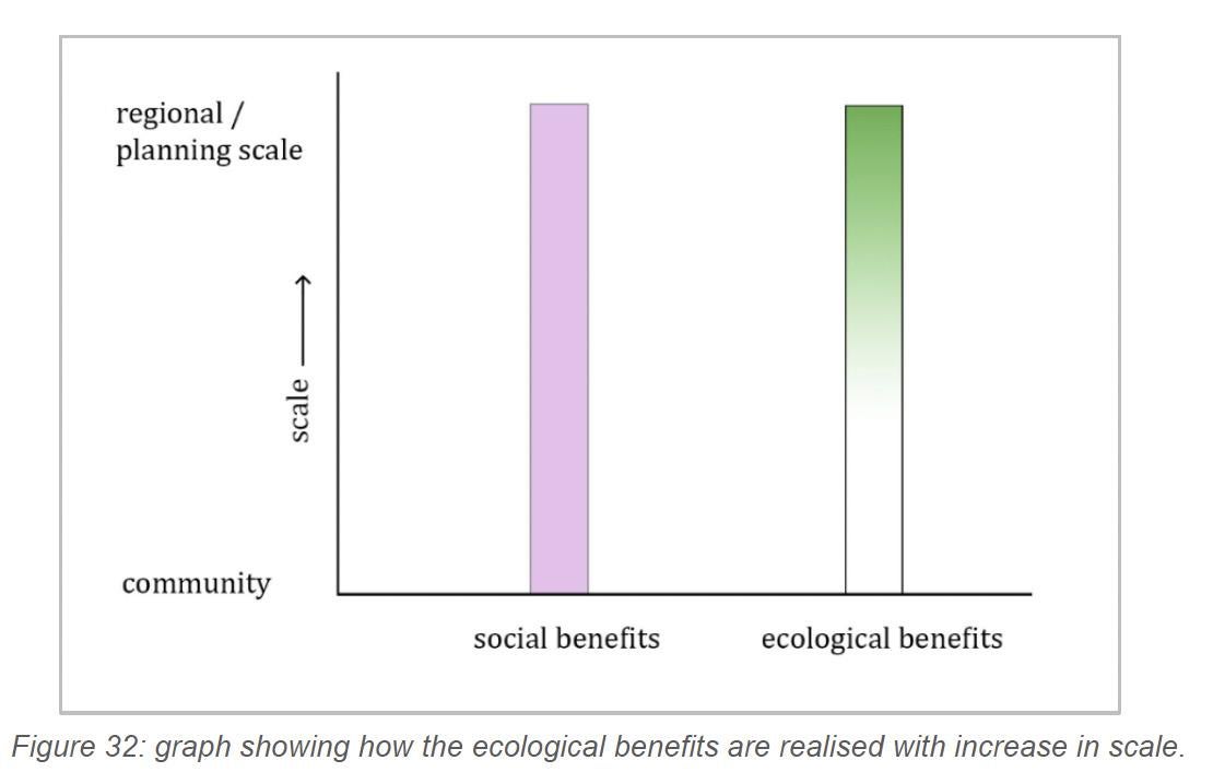
By evaluating the planning and design considerations followed by Earthwatch, key areas for optimisation especially in the site selection and site design stages were found for which new principles are recommended (see Fig.5, Fig.6). These principles can be used to enhance the design of the tiny forest to facilitate social benefits it can provide at the community scale and also achieve wider ecological benefits at the planning scale (see Fig. 4).


Thank you for your time
Nagma Manoharan