13 minute read
by Margaret S. Beale


The Starbuck Family and The Parliament House
7
by Margaret S. Beale
THE PRINCIPAL GOAL of this study is to determine if a correlation exists between 10 Pine Street and "Parliament House", a dwelling known as the home of Nathaniel and Mary (Coffin) Starbuck, which was located in the section of Old Sherborn known as Cambridge as early as 1667. According to Nantucket lore, John Folger, a Quaker carpenter, told his grandson, Joseph Austin, that he had incorporated into the house on the corner of Pine and School Streets materials salvaged from "Parliament House".i
Building materials have been recycled ever since the town of Sherborn was relocated to the Wesco Acre Lots in the 1700's. Accompanying the name "Parliament House", however, is the important historical connection with the Starbuck family and the first Quaker meetings conducted on the island. Nathaniel and Mary Starbuck's home "Parliament House", was an integral part of Nantucket's early history as the locus of governmental, business and religious activity.
The first three Starbuck generations provided the early Nantucket settlers with community and spiritual leadership. Edward Starbuck, one of the first purchasers, conducted transactions between the settlers and the Indians. Of him it was written by a contemporary:
"He was a man of great firmness and his influence among the Indians was so great that if at any time suspicion or alarm arose among the early settlers he was always in requisition to explain the apparent causes thereof and suggest a palliation for their rude and inexplicable action, which served to allay the fears of the more timid.2
Nathaniel Starbuck, Edward's oldest child, was also greatly respected. Nathaniel's reputation in the settlement, however, was over- shadowed by that of his wife, Mary Coffin Starbuck, a daughter of Tristram Coffin. In his Journal, the Quaker visitor, John Richardson, stated:
"Nathaniel appeared to be not a man of Mean Parts, but she (Mary) so far exceeded him in soundness of Judgement, clearness of Understanding, and elegant way of expressing herself ... that it tended to lessen the Qualifications of her Husband."3
8
HISTORIC NANTUCKET
In 1701, Mary Starbuck was fifty-six years of age when she was introduced to John Richardson, the first influential Quaker minister to visit Nantucket. Accredited with the conversion of Mary to Quakerism, Richardson wrote in his Journal: "At the first sight of her it sprang in my heart, To this woman is the everlasting Love of God".4
Of her character and community standing, Richardson noted: "The islanders esteemed her as a Judge among them, for little of Moment was done without her".5
John Richardson held his first meeting at Nathaniel and Mary's home, and in such an impressive room that he described it in his Journal:
"The large and bright rubbbed room was set with suitable Seats of Chairs, the Glass Windows taken out of the frames, and many Chairs placed without comfortably, so that I did not see anything a wanting, according to the Place, but something to stand on, for I was not free to set my Feet upon a fine Cane Chair, lest I should break it. "6
Thomas Story, equally known with Richardson as a Quaker missionary, traveled to Nantucket in 1704, described the meeting room in Nathaniel's house to be "pretty large and open".7 As a result of these recorded events and accounts, "Parliament House" has been absorbed into the Island's history.
In 1708, Patrick Henderson, who organized the weekly meeting for worship, was received by fifty fellow Quakers, and by 1711, the meetings had outgrown the private residence. Nathaniel Starbuck, Jr., who held the post of Clerk for the Men's Monthly Meeting until 1733, donated a piece of land north of Elihu Coleman's house. At the time of Mary Starbuck's death in 1717, seventy-five islanders had been converted to Quakerism, her son, Nathaniel, Jr., had assumed some religious leadership and was to become one cf the principal financiers of the whaling industry, and the area bordering the new harbor, called Wesco Acres, was being developed.
Nathaniel and Mary Starbuck's home was called "Parliament, House" as early as 1661, a fact documented by the following quote from Book 1 of the Book of Deeds:
. . . "the one half of the accommodation to Tristram Coffin (word?) being assigned to Mary Starbuck and Nathaniel Starbuck her Husband as by deed appears the House Lot was laid out by Peter Folger, Edward Starbuck, and Thomas Macy, Tristram also being pre-
Starbuck Family/Parliament House
sent — at the place commonly called the Parliament House 60 square rods bounded with the land of Thomas Mayhew on the South and with the land of James Coffin on the North and on the East with the land of Stephen Greenleaf on the West by the commons (word?) land allowed at the East End with reference to Rubbage Land more or less."8
9
This title was recorded only five years after Nathaniel and Mary's marriage and eight years after the island had been settled. The Starbuck home became the site of town meetings and a trading post.
Nathaniel Starbuck, who survived his wife, Mary, died in 1719; his estate passed to his three sons, Nathaniel, Jethro, and Barnabas. The Cambridge property remained in the Starbuck family until 1737, when Nathaniel Starbuck (blacksmith), Paul Starbuck (glazier), William Starbuck and Thomas Starbuck (yeoman) sold to George Hussey "all those tracts and parcels of lands and accommodations on so Island of Nantucket which Nathaniel Starbuck, late of Sherborn aforesaid Deceased, gave unto his three sons... 9
The Hussey family, which by the mid-1700's had married into the Starbuck family, kept the "Parliament lot" until 1810, when Joseph Austin, who married George Hussey's youngest child, Rachel, began to buy up the Hussey's interests. Dying in 1817, Joseph Austin had collected "6/8 of the Cambridge property, with all the fence, stock, hay and farming utensils; 350 rods of land adjoining Cambridge to the eastward, Vz the house and homestead". 10
After the death of her husband, Rachel Austin sold to Paul Gardner in 1821 "a certain tract, piece, or parcel of land... Known by the name of Cambridge... Also a certain piece or tract of land... before described called and known by the name of the Parliament Lot containing about 3 acres. . . with all the fences which are standing and laying on the said land which George Hussey purchased of the heirs of William Starbuck."n
In 1835, Robert Rogers filed a court suit against Paul Gardner and his business partner, Seth Swain; Rogers received Paul Gardner's Cambridge property as payment of debts. Following 1835, the Cambridge property has had several owners and is presently included in the estate of Ann Sanford.
The Fish Lots and #10 Pine Street
The origins of #10 Pine Street can be traced back to the division of the Fish Lots in 1717. Originally included in the area called Wesco and laid out as agricultural land, the Fish Lots were divided into twenty-
Starbuck Family/Parliament House
11
seven shares and were allocated for fishing and dwellings. The development of this land coincided with the beginning of the whaling industry and the demand that followed for wharfs and beach front property. Similar to the New England fish-flake and maritime storage lots, these shares measured 8 rods wide, tapering 7 46/100 of a rod in the south. 12
Running north-south through the middle of the lots was the public street or way, which is today Fair Street. The western boundary was defined by Pine Street. Union Street, which was under the hill known as Quanaty Bank, marked the eastern bounds. The Pine and Fair Street insulae represents the residential rear lots; the high contours between Union and Orange Street explain why these lots were unsuitable for fishing purposes. 13
In 1722, due to confusion over the proper boundaries of the lots, the town decided to resurvey "certain tracts of lands called house lots or dividends."i4 The failure of George Hussey's name to appear among the owners of lot #23 could have been the result of this confusion. Rerecordings, surrenders and reallocations followed a series of town meetings; plots were adjusted to incorporate ninety new plans which so modified the earlier divisions that they virtually disappeared. 15
The present day house is situated on property once belonging to Stephen Coffin, Richard Gardner and William Worth: the first owners of the 23rd share in the Fish Lots. George Hussey's name was excluded from the original document, a fact which was acknowledged in the transfer of 1/6 part of his share to William Hay in 1735: "nevertheless my name is omitted as a partisan in so lot upon record". 16
William Hay kept the land for ten years, selling it in 1745 to George's brother, Silvanus Hussey. In 1765, Charles Bunker purchased from Silvanus Hussey "a certain piece of land called the 23rd share of the fish lot division containing 221/2 rods and it is to be at the west end of so share.. . "17 The word 'house' had not been mentioned in any of the transactions taking place between 1717 and 1765.
No historical accounts exist that describe the Charles Bunker "settlement" which evolved on the corner of Pine and School Streets between 1765 and 1813. Charles Bunker, a blacksmith, died in debt in 1813. His estate consisting of a house, shop, barn, bakehouse and outbuildings was appraised at $900.00 by the Nantucket Marine Insurance Company.
In lieu of payment, the Nantucket Marine Insurance Company gained title to Bunker's land and buildings, selling part interest to John Folger in 1819 and Frederick Jones in 1820. The deed of ownership drawn up by the Nantucket Marine Insurance Company specifically
12
HISTORIC NANTUCKET describes how the house and property was to be divided between Folger and Jones:
"John Folger shall have the south part of the house and land ... beginning at the southwest corner of said land and measuring to the Northward as the West line of the land runs 16 ft.; then on a line with the partition that separates the front entry from the south front room until it meets the west jam of the fireplace in the south room; then as the fireplace runs until it comes to the head of the east jam of said fireplace; then on a right angle line to the East side of the room; thence on the line with the middle of the partition wall of the said east side of the room 1 ft. and 6"; thence on a right angle line through into the kitchen extending across the kitchen to the North side of the south door post of the kitchen, which is fourteen feet six inches from the south side of the land; thence extending from said door post to the eastward on a line parallel with the south line of the premises unitl it comes so as to leave 12 feet to the westward of Lydia Swain's land, for a passway in from the street for the owners of the north part of the territory; from thence a right angle out to the south side of the premises leaving the aforesaid passway of 12 feet in width from the west line of Lydia Swain's land to the east end of the aforesaid John Folger's land.. ."18
In 1824, John Folger purchased from Frederick Jones the remaining interest in the house.
In drawing any conclusions as to whether John Folger incorporated material from "Parliament House", one must take into consideration that 152 years had passed since Nathaniel and Mary's home had been built.
The first mention of "Parliament House" following 1667 appears in 1809: George Hussey sold the Cambridge property, including the "Parliament Lot" to his son-in-law, Robert Brayton. From this description, the condition of the house or if the house is still standing, cannot be determined. More than likely, only the foundation of the house remained and any salvageable material had already been removed from the property.
An interesting relationship, however, exists between John Folger and the Joseph Austin family, who owned the "Parliament Lot" in Cambridge from 1810 -1821. Mary Folger, John's daughter, married Joseph's son, James Austin, in 1833. The supposition that John Folger
Starbuck Family/Parliament House
13 purchased "Parliament House" material from the Austin family lacks substantial evidence and sound documentation.
Following the death of John Folger in 1864, one-half the interest in #10 Pine Street passed to his daughter, Mary F. Austin, and his grandchildren, Laban Swain, Thurston Swain, and Ariston Swain. Mary's husband, James, bought the grandchildren's interests in 1869 and lived in the house until his death in 1892.
In his later years, James Austin, a tinsmith, was characterized as a "well-known member of the Society of Friends who lived in the north chambers". 19
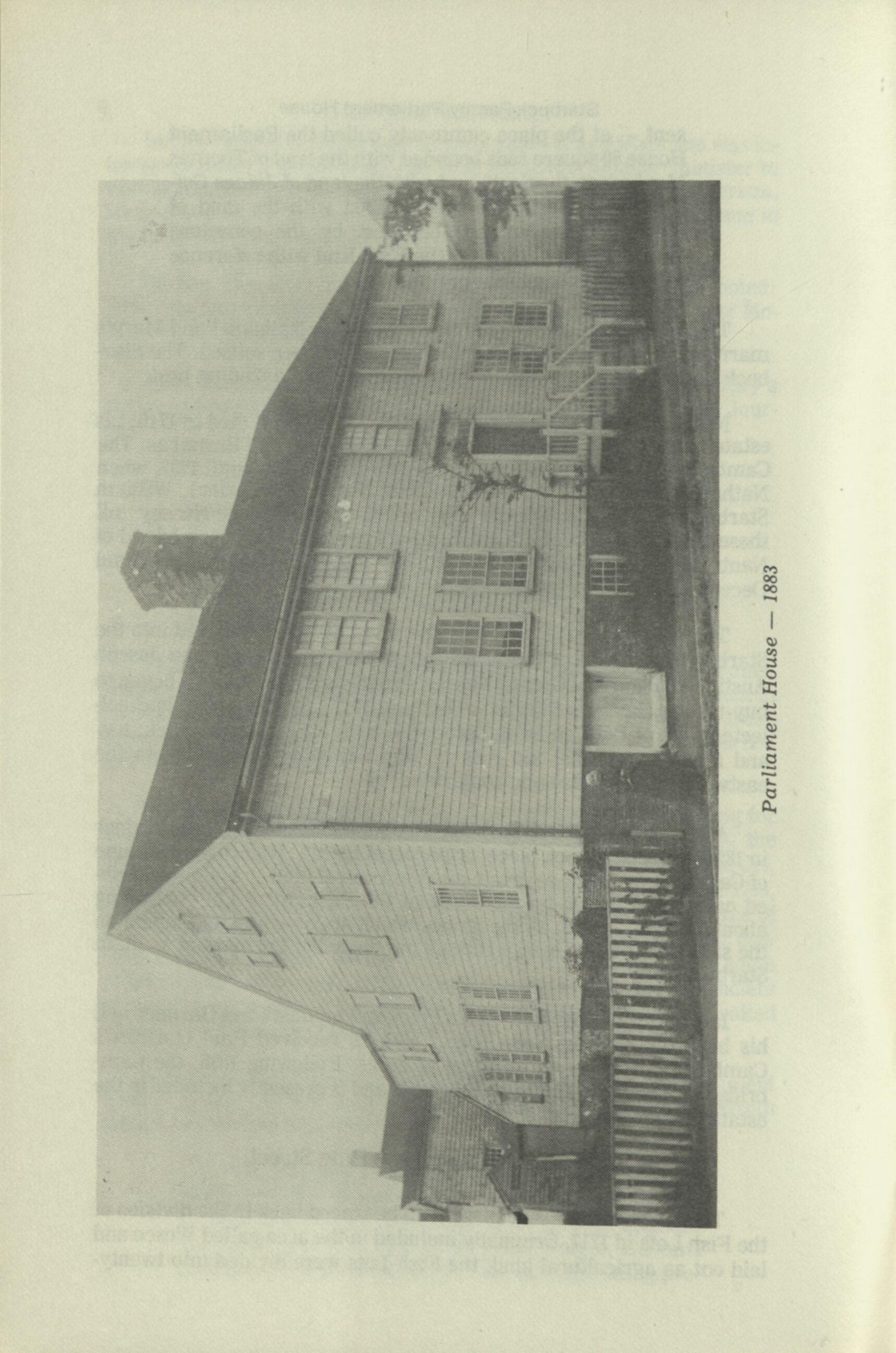
Between 1924 and 1945, Julia B. Farrington and Mary E. Crosby advertised in The Inquirer and Mirror their home as a boarding house: "Old Parliament House. . . Spacious rooms. . . Excellent table. . . Meals served singly or by the week".20 The present owner, Mildred Gieg, resides in the south side of the house, renting the remaining portion.
Conclusion
The evolution of #10 Pine Street has successfully been traced from its beginning as a late 17th century/early 18th century dwelling, to its present structure that looks probably as it did by 1864, with the exception of one addition.
The lack of evidence to support John Folger's incorporation of material from "Parliament House" in Cambridge into #10 Pine Street does not totally negate the story's credibility. Oral tradition composes an essential part of a small community's history and should be explored and utilized in the research process. In the case of #10 Pine Street, Island lore has overshadowed the house's early architectural and social history - a fascinating and significant story in itself.
References
1. Henry Barnard Worth, "Early Houses at Nantucket", Proceedings
of the Nantucket Historical Association, 1904, p. 19-24.
2. Alexander Starbuck, The History of Nantucket: County, Island, and Town; Including Genealogies of the First Settlers, Rutland, Vermont, 1969, 9. 802.
3. Ibid., p. 520
14 5. Ibid. HISTORIC NANTUCKET
6. Ibid.
7. Ibid., p. 526
8. Nantucket County Deeds Records, Book 1, P. 12. 9. Ibid., Book 4, p. 164
10. Nantucket County Probate Court Records, §504.
11. Nantucket County Deeds Records, Book 26, p. 230. 12. Michael Hogo-Brunt, et al, under the direction of Barclay G. Jones,
An Historical Survey of the Physical Development of Nantucket: A Brief Narrative History and Documentary Source Material, sponsored by the Division of Urban Studies Center for Housing and Environmental Studies, published at Cornell University, Ithaca, New York, 1969, p. 24.
13. Ibid.
14. Ibid., p. 25
15. Ibid.
16. Nantucket County Deeds Records, Book 4, p. 126 17. Ibid., Book 7, p. 74. 18. Ibid., Book 25, p. 330.
19. Grace Brown Gardner, Folders of Streets and Places, §24.
Miss Beale prepared this study while a student with the Preservation Institute at the Coffin School in Nantucket in 1981. She wishes to give special thanks to Mildred Gieg and Mrs. Henry Koch, and Prof. Paul Buchanan and Prof. Herschel Shepard for "their cooperation and patience throughout the project".