14 minute read
Surviving the Cold

BY LT JON HILL
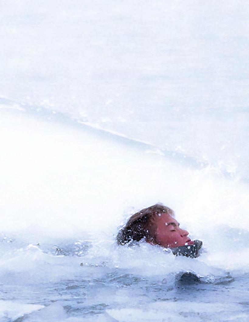
n January 8th, 2014, a MH-53 crashed into the frigid waters off the coast of Virginia. Tragically, three of the five crew members were killed. The following week, an F/A-18 crashed into the same coastal waters. The pilot ejected and was unable to enter his life raft. He was hypothermic following his rescue.
Advertisement
These two events highlight the dangers of operating aircraft over cold water and have brought a renewed focus on cold water survival among the naval aviation community.
With water temperatures below 50 degrees Fahrenheit or when the wind-chill-corrected outside air temperature is 32 degrees Fahrenheit or less, OPNAV 3710.7U mandates aircrew wear anti exposure suits.
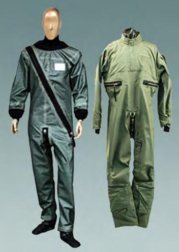
The two main dry suits issued to aircrew are the CWU86 and the OTS-600. Recce features of the CWU-86 include a horizontal zipper that closes around the waist. The OTS-600 can be easily identified by the diagonal zipper which closes across the chest. Although these suits are similar in purpose, there are very important differences in survival time and time of useful consciousness once exposed to cold water. In addition to these dry suits, air
crew members are issued mesh liners and long underwear. The green and white mesh 23/P liner is worn beneath the CWU-86 dry suit. The standard, waffle-weave, cotton, long underwear 43/44P can be worn under either the CWU-86 or OTS-600 dry suits. These two products have a profound effect on survival time in the water.
During every flight, the aircrew brief search-andrescue procedures and on-scene-commander responsibilities. We hear it regularly, but what are the details of the rescue operation? Consider the following example when calculating the estimated time aircrew can expect to spend in the water and, most importantly, estimating how long it will take the trauma unit to arrive.
Say the rescue base is located 75 nautical miles from the mishap aircrew position, the SAR helicopter crew is on stand by and the MH-60T “Jayhawk” is the closest available rescue asset. We will also assume the trauma unit is at the rescue base. How long could you survive in the frigid water? From the initial mayday call on guard or through ATC to the district SAR office, it’s five minutes. From the district SAR dispatch to the MH-60T takeoff off, it’s 30 minutes. From the rescue base, 75 nautical miles at 135 knots ground speed, to the mishap location, it’s 34 minutes. Single unit “Victor Sierra” search pattern for four square miles and rescue hoist, it’s 30 minutes. Collectively, from the time you enter the water to the time the rescue swimmer hoists you out is one hour and 39 minutes. The en route time from mishap location to the trauma unit is 34 minutes. Given these estimates, the time from entering the water to arriving at the hospital is two hours and 13
minutes. These times are minimums and can increase due to the weather and extended search times.
Two and a half hours, in a perfect scenario, from the time of your mishap to medical care is significant; just think, how many times has the mission you’ve been conducting taken you well over 75 miles away from the primary SAR base?
Chapter 8 of 3710.7U, Aeromedical and Survival, contains a chart entitled Cold water immersed functional exposure limits by type of exposure protection. Refer to figure 5. This chart shows varying combinations of dry suits and undergarments and provides estimated “functional time” based off body-fat percentages and water temperatures. Functional time is the predicted time of useful consciousness, but let’s face it, if you’re unconscious in a normal sea state, your chances of survival begin to approach zero. For our analysis of predicted survival times we will use a 15-18 percent body fat, 45 degree Fahrenheit water temperature and dry suit and undergarment combinations typically worn by VFA aircrew. Starting with the CWU-86 dry suit only, in 45 degree water we see the expected functional time of aircrew is less than 90 minutes. When we add the 23/P, green and white mesh liner to the CWU-86 dry

suit, aircrew functional time is nearly doubled to around 150 minutes. The OTS-600 dry suit by itself in the same conditions has a functional time of less than 135 minutes. Note the impact of the inner surface fleece of the OTS-600, functional time is increased 45 minutes compared to the CWU-86. Adding in the 43 and the 44/P cotton waffle-weave long underwear to the OTS600 extends functional time to about 285 minutes. We can clearly see the benefit of wearing liners as well as the increased level of protection offered by the OTS600 dry suit and long underwear combination.
The estimated functional time is great information, but let’s take it a step further and compare the information we know about the SAR effort with expected survival times in cold water. From there, we can determine where survival time equals estimated rescue time. We’ll represent this as a distance that aircrew can use when planning over-water flights. Our goal will be to find out how far a rescue helicopter can fly before a survivor loses consciousness. The fixed time items for a rescue effort are the dispatch (five minutes), takeoff (30 minutes) and estimated search and hoist time (30 minutes), which totals 65 minutes.
We will first take a look at the CWU-86 dry suit
since, in the above example, we know it has the shortest functional time compared to the OTS-600.
In the above scenario, a survivor wearing the CWU
86 dry suit with no liner has an estimated functional time of less than 90 minutes. With 65 minutes of fixed time items, and 90 minutes of functional time we are left with 25 minutes of transit time for the rescue helicopter. At 135 knots ground speed, the MH-60T will cover 55 nautical miles in 25 minutes. Think about the implications of this situation. How often have you flown over water and been greater than 55 nautical miles from your primary SAR base? In theory, even if you survive your mishap, are able to remain afloat, and a near flawless rescue effort is made, if you are outside of 55 nautical miles while wearing a CWU-86 dry suit with no liner, your chances of surviving 45 degree water are nearly zero.
There is a more optimal situation, and your liner is the answer. The functional time for the CWU-86 dry suit and 23/P liner combination is less than 150 minutes which gives the rescue helicopter 85 minutes of travel time.
That equates to nearly 193 nautical miles, a much preferred situation. Figure 6 is a graphical overlay of the W-72 working area used by aircraft from NAS Oceana and NAS Norfolk.
The red rings represent the CWU-86 dry suit with no liner and are an estimated distance of 55 nautical miles from the SAR base while the orange rings represent the OTS-600 with no liner and are an estimated distance of 155 nautical miles from the SAR base.
The northern red ring and the northern orange ring represent the distance where survival time equals rescue time if SAR assets are launched from NAS Norfolk.
The two main dry suits, shown above, are issued to aircrew to help prevent hypothermia. The green and white mesh 23/P inner liner is worn beneath the CWU-86 dry suit. The standard, waffle-weave, cotton, long underwear 43/44P can be worn under either the CWU-86 or OTS-600 dry suits. These products have a profound effect on survival time in the water.

This graphic demonstrates how survival time relates to rescue time. A major concern during an accident is how to increase survival time. Wearing proper gear can make the differens between life and death.
The southern red ring and southern orange ring are distances from USCG station Elizabeth City, N.C. With this graphic you can clearly see, if aircrew are wearing a CWU-86 dry suits with no liners, their chances of surviving a cold water immersion in 1-3B eastward are nearly zero and the OTS-600 with no liner only covers you through half of 3C and 2D.
In months when the risk of a post-mishap, cold-water immersion are high, mission commanders must use ORM, especially for night flights over open water or when water temperatures are below 50 degrees Fahrenheit. There is also the opportunity for safety departments to reexamine survival gear and ensure aircrew are provided with the most up to date equipment, including vest-mounted orange rescue streamers for increased visibility, HAU-12/P exposure gloves and the HGU-32/P exposure hood.
Your ability to survive in cold water after a mishap rests solely on thorough preparation of your survival gear and an understanding of the benefits your gear can provide. Next time you are going on an over-water mission, take the extra time to put on your liner.
LT HILL FLIES WITH VAQ-131

CRM Crew Resource Management
Naval School of Aviation Safety Crew Resource Management 181 Chambers Ave., Suite A Pensacola FL 32508-5271 (850) 452-3181 (DSN: 459) • Fax (850)452-8732 (DSN: 459) https://www.netc.navy.mil/nascweb/crm/crm.htm
DECISION MAKING • ASSERTIVENESS • MISSION ANALYSIS • COMMUNICATION • LEADERSHIP • ADAPTABILITY/FLEXIBILITY • SITUATIONAL AWARENESS
Just Another Cross-Country Weekend
LT BECCA SMITH
et-setting is one of the highlights of advanced helicopter training, and one cross-country weekend, we found ourselves in Atlanta, Georgia. It was Sunday morning and we were fat, dumb and happy. It had been a successful, albeit rainy, weekend and we were three short flights from home. A large storm was west of Atlanta and north of South Whiting Field (KNDZ), so we planned to head south to avoid it and then west to KNDZ.
Everything looked good on preflight and start-up. I was smug because the other two crews we were with had to service their hydraulic and transmission systems. That’s when the holes started lining up in the proverbial block of Swiss cheese.
After receiving ATIS and calling for clearance, we switched to ground to inform them we would be requesting a present-position takeoff. They switched us to Tower and I requested takeoff. Crickets. I requested again. Crickets. I switched back to Ground. Crickets. By this time, my comrades had finished their servicing and had started up. I switched to UHF and contacted them on the discrete frequency we had discussed.
After a series of attempts, we determined that we could transmit on VHF, but not receive. I asked another pilot to inform Tower that our aircraft would be shutting down to troubleshoot and to cancel our clearance. I also told them not to wait on us and that we would see them back at KNDZ.
After shutting down, I called maintenance and the CDO. Since I had a working UHF, they both recommended I plan a route that would accommodate UHFonly communications. My students and I pulled out the charts and approach plates. The only route we could find was to head west to Montgomery (KMGM) and then south to KNDZ.
I was apprehensive because ceilings were forecasted to remain low for the duration of the flight as a result of the storm. To get to KMGM, we had to fly IFR for the entire route, and the last thing I wanted to do was go lost comm while IMC. We discussed the possibility but decided that we had no reason to believe that the UHF would stop working. After all, they were two completely separate systems. We filed IFR, started up, got clearance and took off using the UHF radio.
Shortly after takeoff, we found ourselves squarely in the clouds with heavy rain. No big deal. The mighty TH-57 is an all-weather aircraft. As we continued west, we started having issues communicating with approach on UHF. I asked one of my students to look up a VHF frequency for approach on the off chance our VHF fixed itself. We plugged in the frequency and it worked. There was no avenue of fame, yet.
I explained to the controller the nature of our radio issues. He gave us a handful of UHF and VHF frequencies to try. The only one that worked was the VHF frequency we had initially used to contact him. My students and I began discussing what we would do if we lost contact with him and whether we should turn back to Atlanta (KPDK) or continue on to KMGM.
As I was about to inform approach that we wanted to return to KPDK, approach asked us if we were in a turn. I looked at my RMI and my copilot’s RMI: they were steady. My observer was following along in the back with fore flight and informed us it looked like we had completed a 270 degree turn. He instructed us to look at our magnetic compasses and sure enough, our magnetic compasses were showing a 120 degree difference in heading. We manually slaved the RMIs and made several attempts at troubleshooting. The RMIs began spinning.
We were still IMC, had unreliable radios and appeared to have lost our directional gyro. I thought we should declare an emergency, and my students agreed. My copilot pressed the magic button, and I declared an emergency with approach. I told him the nature of the emergency and requested vectors back to KPDK. We had only been airborne for about 30 minutes, and I assumed KPDK was our closest and best option.
The weather had been fine when we took off and had been forecasted to stay the same. Approach said there was an airport that was 10 miles away with an ILS (West Georgia Regional, KCTJ). My copilot looked it
up in the approach plates to see if we could do it. The turned to doubt. My copilot referenced the Atari-era ceilings were low, but we had the approach plate and GPS and said we were about a half mile from the airthe weather, so we accepted. port. Holding our altitude and heading, we frantically
As approach vectored us, we divvied up responsibiliscanned in front of the rain-distorted windscreen. ties. My copilot was responsible for figuring out our rollJust as we were about to admit defeat and go missed out headings on the magnetic compass and calling them. approach for a second time, I looked to the right and She also briefed the approach and kept me honest with left of the helicopter. At 7 o’clock and no more than 50 heading. My observer, who was eagerly sticking his head yards, I saw the huge, white approach end numbers. between the seats and white-knuckling the crossbars, There were a few choice words, followed by “runway in helped by calling out my altitude and airspeed deviations. sight.” We turned, landed and shut down without any
I had done plenty of no-gyro PAR and TACAN further incident. approaches with students in VMC, and I naively We climbed out of the helicopter. A wave of relief thought that a failed card ILS in the clouds would be swept through us as we realized the gravity of what as easy as a VMC no-gyro PAR. I could not have been we had successfully battled through . When the more wrong. I also assumed that my students had maintenance representative arrived the following day, already completed their failed-card training hops. Strike two. Upon reaching final, I turned to intercept and went full deflection almost immediately. I held my altitude and informed approach that I was executing a missed approach and requested vectors for another attempt.
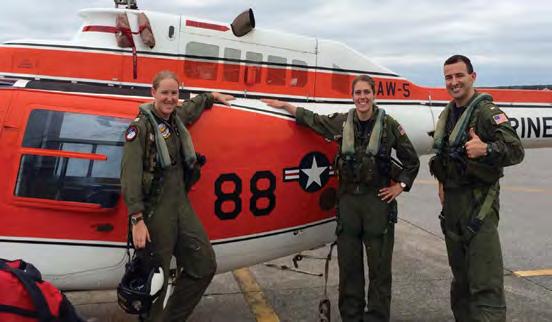
My observer, still white-knuckled, mentioned that we should request “no-gyro” vectors. I relayed the Photo courtesy of HT-8 request to approach, From left to right, LT Becca Smith, ENS Carrie Rose and ENS Jason Weeks pose for a photo after a they obliged and our flight. The three faced trouble during a missed approach during a training session. workload was instantly cut in half. As we snaked and we discovered that our all-weather aircraft’s avionic slithered through the pattern and turned onto the final compartment was a veritable swimming pool, and the approach course, confidence built in the cockpit. With the source of our faulty equipment. help of my students, I was able to maintain something that During the debrief of the events, we all agreed that resembled the course and glideslope of the approach we our success was as a direct result of solid CRM. The were attempting. student-instructor hierarchy had been left at the door As we got closer and the ILS became more sensiduring the emergency, and all three of us had equal tive, the CDI began to walk out. We were about 200 stakes in finding a place to land. We made a few misfeet above decision height, right at the base of the steps along the way, but our ability to swallow our pride, clouds, and the rain on the windscreen was nearly accept critique and offer guidance to each other helped blinding. Our focus had subconsciously shifted from us successfully navigate to a safe conclusion of a lessan aggressive partial panel scan to looking outside than-textbook situation. the aircraft for the airport. Before we knew it, I had gone full deflection again. Our confidence quickly LT SMITH FLIES WITH HT-8.